Embed Size (px)
Citation preview

1
EMME -EARTHQUAKE MODEL OF MIDDLE EAST REGION: HAZARD, RISK
ASSESSMENT, ECONOMICS & MITIGATION
Karin Sesetyan1 , Cuneyt Tuzun
1, Domenico Giardini
2, Mustafa Erdik
1
1. INTRODUCTION
The number of people died in earthquakes and tsunamis worldwide in the last decade is about
half a million, based on recent statistics. The majority of this life loss occurred in developing
countries where population and urbanization is increasing rapidly without any major control,
there by also yielding a high risk for the future. The Middle East region is located at the
junction of major tectonic plates, namely the African, Arabian and Eurasian plates, resulting
in very high tectonic activity. Some of the major earthquake disasters in human history
occurred in the Middle East, affecting most countries in the region. Being one of the most
seismically active regions of the world, Middle East, extending from Turkey to India, is also
a key region in terms of urbanization, energy reserves and industrialization trend. The region
under consideration involves world’s most populated capitals and cities with key economical
importance such as Istanbul, Baghdad, Tehran, Jeddah, Riyadh, Cairo, Kabul, Karachi and
Lahore.
It is a well known fact that earthquakes cause, not only direct damage on built environment
such as buildings, infrastructure or lifeline systems and result in human life and economic
losses but have also secondary effects such as social and economic losses. As a consequence
of the high probability of earthquake occurrence combined with high population growth, poor
construction standards and practice and lack of proper mitigation strategies, Middle East
represents one of the most seismically vulnerable regions worldwide.
Especially starting from 1990’s, seismic risk and associated mitigation strategies have been
assessed in worldwide scale through different initiatives funded and coordinated by
international organizations such as United Nations and World Bank. As a result of these
projects many valuable and applicable results have been obtained. As one of the latest
initiatives, GEM (The Global Earthquake Model) aims at carrying former studies a step
further by allowing meaningful comparisons between different regions through uniform data,
methodologies, models and training. Through interactive research activities performed by
researchers from different disciplines, such as engineering and geosciences, the project will
provide a comprehensive and uniform evaluation of the seismic risk and associated mitigation
studies. The results of the project both in terms of risk evaluation and the developed IT
structure will be widely used throughout the world especially in developing countries located
in high seismicity regions.
EMME (Earthquake Model of the Middle East Region) aims at the assessment of seismic
hazard, the associated risk in terms of structural damages, casualties and economic losses and
also at the evaluation of the effects of relevant mitigation measures in the Middle East region
in concert with the aims and tools of GEM. EMME project encompasses several modules
such as the Seismic Hazard Module, Risk Module, Socio- Economic Loss Module and the
development of an IT infrastructure or platform for the integration and application of
modules under consideration. The methodologies and software developments within the
context of EMME will be compatible with GEM in order to enable the integration process.
As such, a comprehensive interaction between the two projects is foreseen.

2
2. OVERALL GOALS
EMME aims to contribute to and facilitate the seismic risk reduction through the realization
of the following specific tasks:
• Calculate seismic hazard uniformly and with the highest standards
• Rigorously validate earthquake and shaking probabilities using regional and global
data
• Communicate seismic risk clearly, accurately, and transparently to all users
• Integrate local expertise in a regional and global context
• Monitor and update changing infrastructure and vulnerability
• Build seismic risk management capacity in the whole region
• Enable dialogue with decision-makers
• Implement EMME as part of the Global Earthquake Model
EMME will enable users to take the following specific actions to achieve risk-reducing
outcomes:
• Improved earthquake preparation and response
• Adoption and enforcement of building codes
• Implementing seismic mitigation measures
• Enabling accurate post-earthquake alerts and rapid assessment of direct and indirect
losses
• Increased earthquake insurance usage
• Ensuring uniform comparability of seismic risk across multiple geographies
EMME’s long-term impact is expected to be a more structured approach to seismic risk
mitigation, leading to reduced monetary losses and casualties. Improved building
construction practice and efficient risk allocation will lead to overall reduction of losses.
Public policies for risk mitigations will be based on wider awareness and on more sound,
integrated knowledge. Furthermore, a more robust post-earthquake financial infrastructure
will reduce the reliance of developing nations on charity, thereby speeding their recovery and
avoiding a downward spiral of environmental hazards and economic development.
EMME is planned in such a way that it will form a living model, rather than a static study,
with a flexible, modular architecture to allow addition and updating of components and
datasets, and to maintain it continuously as state-of-the-art and in conformance with national
developments and new international standards. As such, EMME also plans to allow multiple
user types to derive updated products and outputs, and keep up with changing requirements.
The users and beneficiaries of EMME will be broad, and include all those who make
decisions based on seismic risk: seismic agencies, engineers and practitioners, government
officials, insurance and finance industries, emergency responders, risk professionals,
homeowners, investors, and the population at large.
The project is composed of three research modules (hazard, risk and socio-economic impact)
and a phase in which an IT infrastructure will be established for the application of the
methodologies developed in each module. EMME will set a uniform, independent standard
methodology for seismic hazard and risk assessment both in national and regional scales. The
implementation of the methodology proposed in the project is based on a combination of
regional and global elements, and integrates developments of scientific and engineering

3
knowledge as well as IT processes and infrastructure. The hazard, risk and socio-economic
impact modules are divided into sub modules defining the various Work Packages (WPs), as
presented in Figure 1. Each WP has a leading institution also given in Figure 1. The current
partners of EMME are given in Table 1. Apart from the official partners cited in Table 1,
researchers from the National Centre of Excellence in Geology. University of Peshawar,
Pakistan and from the Civil Engineering Department, Jordan University of Science and
Technology are actively contributing to the project. The American University of Beirut is
also at the stage of joining the EMME consortium.
Figure 1. Workflow of EMME
Table 1. EMME Participating Institutes
Partner Short Name Partner Organization Full Name
ETHZ Swiss Federal Instıtute of Technology, Zurich, Switzerland
KOERI Kandilli Observatory and Earthquake Research Institute, Bogazici
University, Istanbul, Turkey
IIEES International Institute of Earthquake Engineering and Seismology,
Tehran Iran
SAU Department of Geophysical Engineering, Sakarya University,
Sakarya, Turkey
METU Department of Civil Engineering, Middle East Technical
University, Ankara, Turkey
CUT Department of Civil Engineering and Geomatics, Cyprus University
of Technology, Nicosia, Cyprus
YU Department of Earth and Environmental Sciences, Yarmouk
University, Irbid, Jordan
NDMA National Disaster Managment Authority, Islamabad, Pakistan
CAPACITY BUILDING (KOERI)
HAZARD MODULE
WP2 – Seismic Sources (SAU)
WP1 – Earthquake Catalog (IIEES)
WP3 – Ground Motion Prediction Equations (METU)
RISK MODULE
WP5 – City Scenarios (YU)
WP4 – Seismic Risk Assessment
(KOERI)
SOCIO-ECONOMIC MODULE
WP6a – Social Impacts (NDMA)
WP6b – Monetary Losses (NDMA)
WP7. Computational Infrastructure & Model Building (ETHZ and KOERI)

4
NED Department of Civil Engineering, NED University of Engineering
and Technology, Karachi, Pakistan
UP National Centre of Excellence in Geology, University of Peshawar,
Pakistan
ACNET Institute of Geophysics, Georgian Academy of Sciences, Tbilisi,
Georgia
ANAS Azerbaijan National Academy of Sciences, Ministry of Emergency
Situations, Baku, Azerbaijan
SCI Institute of Geological Sciences, National Acedemy of Sciences,
Yerevan, Armenia
AUB American University of Beirut, Beirut, Lebanon
AU Anbar University, Al-Anbar, Iraq
EMME aims to compile the available data for the region and to concentrate the efforts on the
homogenization of the data, with special attention on sharing and transferring experience
throughout the region, the improvement of existing databases and filling of possible gaps
whenever possible. Compatibility with data requirements of the global projects (GEM) is also
aimed at all stages. Technology and knowledge will be transferred from parallel projects such
as NERIES, SHARE and GEM. The ELER© (Earthquake Loss Estimation Routine) software
developed by KOERI as a part of EU FP6 NERIES Project will be used for both regional and
city scale earthquake damage and loss computations whereas hazard computations will be
done with the Earthquake hazard computation software developed in GEM.
A main product of EMME will be the open source architecture, through which continuous
refinement, analysis and renewed studies can be implemented by risk professionals. EMME
also pays special care to have outputs for non-experts in order to disseminate the results
widely. The outputs will be in the form of hazard maps, representing probability of ground
shaking at various return periods for a suite of frequencies and with associated uncertainties,
damage to the physical environment, casualties, affected and displaced population and
variations of economic indicators.
3. EMME WORK PACKAGES
The modules of the EMME project and the definitions of WP activities can be summarized as
below.
3.1. Seismic Hazard Assessment Module
EMME adopts the Probabilistic Seismic Hazard Assessment approach. The parameters
required for that purpose are the definition of seismic source zones, determination of ground
motion prediction models applicable to the region and the choice of a proper probabilistic
model. The seismic hazard module will consist of three Work Packages, the earthquake
catalog, seismic sources and ground motion prediction equations, which define the seismic
activity rates (probability of occurrence of earthquakes in time and space) and earthquake
hazard (annual probability of exceedance of a specific ground motion level). This separation
of seismic hazard between events and shaking probabilities is justified on two principal
grounds: (1) validation and testing of hazard can be conducted at the two separate levels of
event and shaking probability, and (2) assessment of seismic risk based on scenario-based or
intensity-based tools initiates from either individual events or occurrence probabilities.

5
The EU FP7 SHARE Project aims at developing a single computational infrastructure on a
par and jointly with the OpenSHA program, a similar initiative supported by the USGS and
SCEC in the United States. Initially located at SED-ETHZ, the SHARE computational
infrastructure will be based on full accessibility and open availability of data, tools and
products, through a dedicated Portal fully connected with the portal for seismological data
developed by the EMSC within the NERIES project. The software will be also open to be
ported and installed in other centers, once fully tested and operational. The hazard assessment
module of EMME will also make use of the methodologies developed within the context of
SHARE especially in terms of accessibility and open availability of databases and
computational tools.
3.1.1. Work Package 1: Earthquake Catalog
Reliable seismic hazard studies depend on having a robust earthquake catalog. The longer the
extent of the catalog and the more reliable the parameters are, the better it is for those doing
seismic hazard analysis. There are two kinds of earthquake catalogs: one is the instrumental
or recent catalog and the other is the historical catalog. In this study, instrumental or recent
catalog refers to the time when seismic monitoring existed while historical refers to the pre-
instrumental period.
The publication of catalog of earthquakes in the middle east region goes back to the
preliminary efforts performed in late 1960’s to early 1980’s, mainly by the researchers
conducted by Prof. N. Ambraseys in Imperial College, London. The book entitled “A History
of Persian Earthquakes”, by Ambraseys and Melville (1982, Cambridge Univ. Press)
represented the first systematic scientific inquiry into the seismic history of Iran. In Turkey,
the first earthquake catalog was published by Ergin et al (1967). Ambraseys has published an
earthquake catalog for Turkey in 1988. For the Arabian countries of middle east the early
efforts was conducted by Melville, Ambraseys and Adams (The Seismicity of Egypt, Arabia
And the Red Sea: A Historical Review; 2005). These catalogs provide detailed descriptive
accounts of virtually all the earthquakes that are now known from historical period, and all
subsequent analyses of seismicity up to the modern instrumental period. The earthquake
catalogs for the Caucasus countries are also published mainly based on the former USSR
earthquake catalogs: four principal earthquake catalogs had been compiled and published: 1)
The Obninsk Bulletin, 2) The Annual series, "Earthquakes in the USSR", 3) The "New
Catalog of Strong Earthquakes in the USSR," compiled by N.V. Shebalin and N.V.
Kondorskaya [1974].4) The “General Catalog of Earthquakes in North Eurasia”, The
regional catalogs are published in Armenia, Azerbaijan and Georgia as well.
The development of practical seismographic instrumentation around the turn of the 20th
century led to the rapid growth of seismologic data, particularly for those events large enough
to register at teleseismic distances on the early instruments.
For the EMME region, a new catalog is in the stage of being formed by combining both the
global and regional catalogs. Catalog reliability, regional magnitude conversion rules,
regional catalog completeness issues are considered during the catalog formation process.
The current state of EMME regional earthquake catalog for the period 1900 – 2010 is
presented in Figure 2.
3.1.2. Work Package 2: Seismic Sources
The delineation of seismic source zones can be accomplished providing that we have a
through knowledge of geology, active tectonics, and complete record of seismicity (paleo+

6
historical+instrumental) of the region under consideration. The geodetic data obtained by
Global Positioning System (GPS) measurements have also become a valuable data set to
complement the other data sets in seismic hazard studies.
The Seismic Sources Work Package of EMME is composed of the following tasks:
Figure 2. Earthquake catalog of the EMME region for the period 1900 - 2010
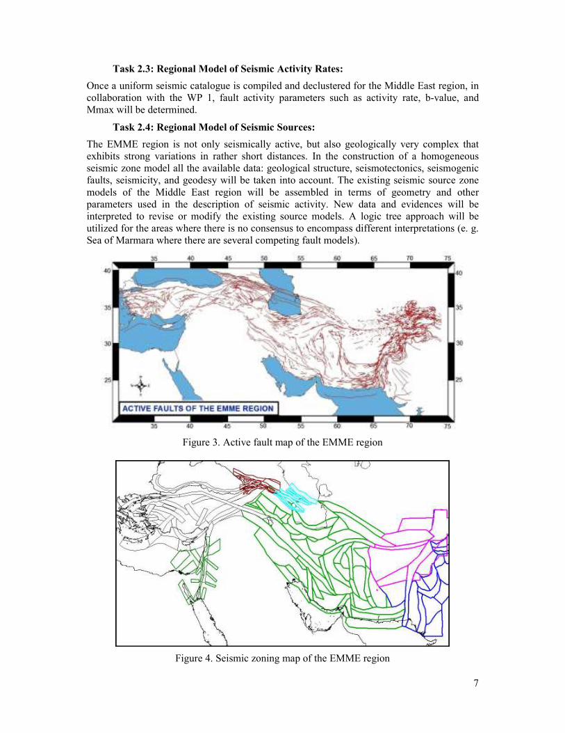
Task 2.1: Regional Compilation of Active Faults
Currently a database of fault parameters for active faults that are capable of generating
earthquakes above a threshold magnitude Mw ≥ 5.5 for the entire EMME region is in the
stage of development with the contribution of all partner institutes for their respective country
and/or regions (Figure 3). This database includes information on the geometry and rates of
movement of faults in a “Fault Section Database” and information on the timing and amounts
of fault displacement in a “PaleoSites Database”.
In the “Fault Section Database” each entry contains the following information: fault name,
fault trace, average dip estimate, average upper seismogenic depth estimate, average lower
seismogenic depth estimate, average long term slip-rate estimate, average aseismic-slip-
factor estimate, Average rake estimate.
Paleoseismic data for some major faults in the Middle East region have been acquired in
several sites and published in the literature. These data are compiled and information on the
timing and amounts of fault displacements will be provided in a “PaleoSites Database” that
also includes the published recurrence intervals and their references.
Task 2.2: Regional Model of Strain and Slip Rates:
Strain and slip rate models only exist parts of the Middle East region. These models either
based on seismicity or GPS data. The comparison of the fault slip rates obtained by
geological, seismic, and geodetic methods provide a good validation test. Especially the GPS
data return realistic estimates of slip rates over large regions. All available data are currently
being compiled in a map format for the Middle East region.
7
Task 2.3: Regional Model of Seismic Activity Rates:
Once a uniform seismic catalogue is compiled and declustered for the Middle East region, in
collaboration with the WP 1, fault activity parameters such as activity rate, b-value, and
Mmax will be determined.
Task 2.4: Regional Model of Seismic Sources:
The EMME region is not only seismically active, but also geologically very complex that
exhibits strong variations in rather short distances. In the construction of a homogeneous
seismic zone model all the available data: geological structure, seismotectonics, seismogenic
faults, seismicity, and geodesy will be taken into account. The existing seismic source zone
models of the Middle East region will be assembled in terms of geometry and other
parameters used in the description of seismic activity. New data and evidences will be
interpreted to revise or modify the existing source models. A logic tree approach will be
utilized for the areas where there is no consensus to encompass different interpretations (e. g.
Sea of Marmara where there are several competing fault models).
Figure 3. Active fault map of the EMME region
Figure 4. Seismic zoning map of the EMME region

8
3.1.3. Work Package 3: Ground Motion Prediction Equations
The objectives of Work Package 3 are to derive region specific ground-motion prediction
equations for the Middle East and Caucuses by considering various ground-motion
parameters that involve spectral acceleration, displacement and peak ground-motion values as
well as to develop region specific tools useful for mapping local site conditions based on
Vs30 proxies, which are derived from the compilations of shallow geology and topography
maps.
One of the goals in EMME is to devise methodologies for the estimation of seismic risk and
loss that are tailored for different cities in the Middle East and Caucuses. To this end, the
ground-motion prediction equations (GMPE) that provide hazard information to these
methods should yield accurate ground motion estimates with low dispersion through simple
functional forms that use the essential geophysical and seismological information. Based on
this fact, the strategy of the work plan in developing the regional ground-motion models is
schematized as:
Level I: regions with different levels of seismic activity (low-to-high seismic activity) with
abundant ground motions associated with well-defined geological, geotechnical and
seismotectonic information
Level II: regions with different levels of seismic activity (low-to-high seismic activity) with
poorly sampled strong-motion databases and/or poor geological, geotechnical and
seismotectonic information
Level III: Seismic prone regions that lack data
The prime methodology that followed in determining the level of sophistication in the
regional GMPEs is to exploit the Level I ground-motion databases. Detailed studies on the
performances of various GMPEs using these databases define the required level of
complexity in the regional predictive model. The results and conclusions derived from the
analysis of Level I datasets will be exported to Level II and III regions such that the most
efficient model(s) will be used in these regions through rational calibration functions. The
synthetics derived for the host-to-target relationships (through the consideration of source and
radiation pattern features of the target region) form the most realistic calibrating functions to
fulfill this objective. Such approaches have been implemented for the Eastern North America
(Campbell, 2003) and some regions in Europe (Douglas et al., 2006).
3.2. Seismic Risk Module
The risk module consists of two Work Packages: Seismic Risk Assessment (WP4), and
Deterministic City Scenarios (WP5). The process will be performed by means of either
deterministic risk scenarios for specific large earthquakes depending on the models
developed in hazard module or probabilistic approach based on the same models and
synthetic earthquake catalogs developed in hazards module. The seismic risk will be
rigorously computed for selected cities.
3.2.1. Work Package 4: Seismic Risk Assessment
The objective of earthquake risk assessment and loss estimation studies is to assess the
natural hazard and consequent risk due to the earthquake quantitatively. The output of these
studies shall be used as a planning tool to execute management and mitigation policies of
seismic disasters and damages within an area of interest.
9
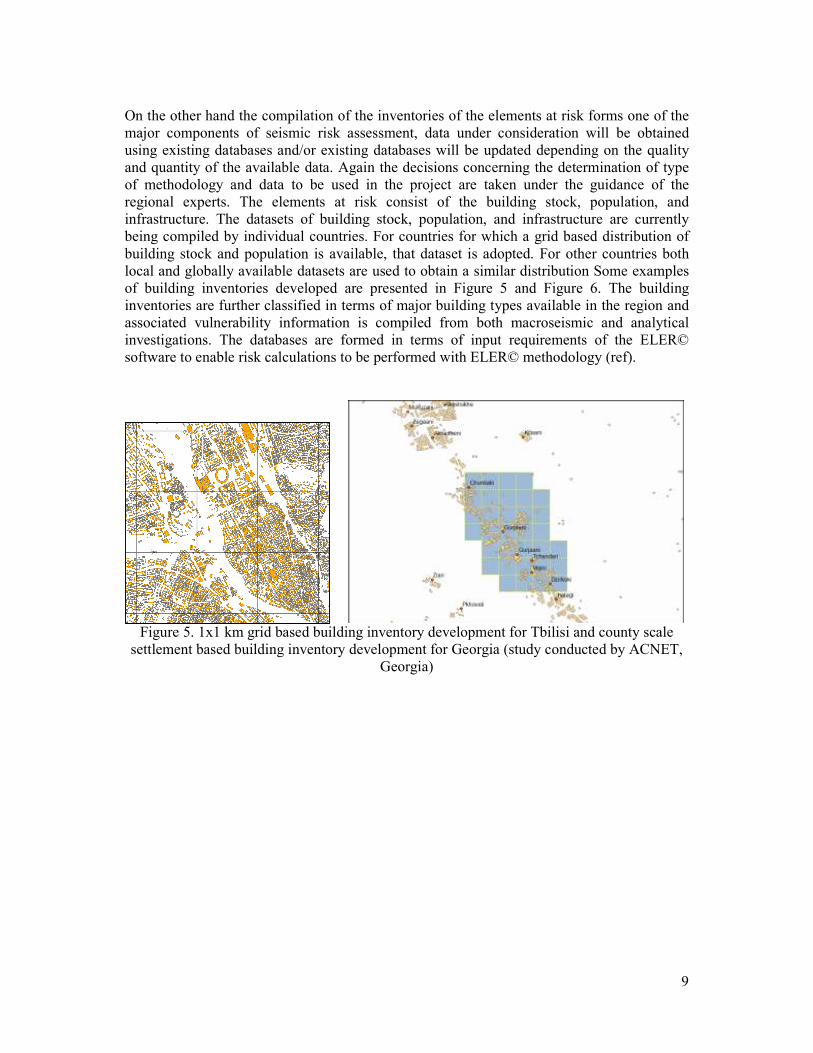
On the other hand the compilation of the inventories of the elements at risk forms one of the
major components of seismic risk assessment, data under consideration will be obtained
using existing databases and/or existing databases will be updated depending on the quality
and quantity of the available data. Again the decisions concerning the determination of type
of methodology and data to be used in the project are taken under the guidance of the
regional experts. The elements at risk consist of the building stock, population, and
infrastructure. The datasets of building stock, population, and infrastructure are currently
being compiled by individual countries. For countries for which a grid based distribution of
building stock and population is available, that dataset is adopted. For other countries both
local and globally available datasets are used to obtain a similar distribution Some examples
of building inventories developed are presented in Figure 5 and Figure 6. The building
inventories are further classified in terms of major building types available in the region and
associated vulnerability information is compiled from both macroseismic and analytical
investigations. The databases are formed in terms of input requirements of the ELER©
software to enable risk calculations to be performed with ELER© methodology (ref).
Figure 5. 1x1 km grid based building inventory development for Tbilisi and county scale
settlement based building inventory development for Georgia (study conducted by ACNET,
Georgia)

10
Figure 6. Digitizing the populated urban areas from the satellite images in Irbid, Jordan and
distribution of buildings into urban areas (study conducted by YU and JUST, Jordan)
3.2.2. Work Package 5: City Scenarios
City Scenarios Work Package forms one of the main components of EMME project Seismic
Risk Module. The major aim of this work package is to achieve the main goals of EMME
which are the improvement of earthquake preparation and response, implementation of
seismic mitigation measures, enabling accurate post-earthquake alerts and rapid assessment
of direct and indirect losses, increase of public and administrative awareness on earthquake
risk and increase of earthquake insurance usage at the city level. As part of this component,
deterministic seismic risk assessment will be carried out for risks associated with specified
earthquake scenarios. The choice of scenarios will depend on the results of the Hazard
Module Packages (WP1-3).To perform a city scenario application within the context of
EMME, candidate cities were required to submit a proposal that would be subject to the
approval of EMMEs’ Steering Committee. A guideline containing both the best practice city
scenario reports (Istanbul and Amman) and the proposal format was prepared by September
30, 2009. A 1st call for City Scenario proposal was lunched by September 30, 2009 and
closed by May 31, 2010. Following the evaluation of the received proposals the cities of
Mashhad (Iran), Karachi (Pakistan) and Irbid (Jordan) were selected to be supported. As the
result of the second evaluation process proposal of Tbilisi (Georgia), Yerevan (Armenia)
have been accepted.
3.3. Work Package 6: Socio-Economic Impacts
The general aim of the socio-economic impact module is to quantify socio-economic effects
of earthquakes over the Middle East region. Specific tasks of the module are the development
of tools and interfaces to the following end:
• Support risk-reducing decisions at an aggregate level in the Middle East.

11
• Calculate probabilistic and event-based financial losses.
• For cost/benefit analysis of mitigating actions such as strengthening/retrofit schemes;
enforcement of building codes; urban development and transformation models.
• For the insurance sector to form the basis of development of new risk transfer
mechanisms, to test the financial feasibility relatively new (i.e. cat-bonds) and
existing (compulsory insurance) risk transfer models in the region.
4. CURRENT STATUS AND FUTURE ACTIONS
The second year of the EMME project has been completed by March 2011. The Mid-term
Assembly Meeting of the project has been held on 31st March – 2
nd April in Amman, Jordan
witht the participation of EMME participants, representatives from GEM (Global earthquake
Model), SHARE (Seismic Hazard Harmonization in Europe ),EMCA ( Earthquake Model of
Central Asia) and local participants.
As the result of discussions it has been decided that the hazard module tasks will be
accomplished by the end of 2011 and will be adopted to the GEM hazard calculation
platform. By that time a complete model of seismicity and active faults will be obtained. By
June 2011, the first three work packages of the project will be completed with all deliverables
submitted, which will enable the computation of the seismic hazard with several models,
logic tree considerations, sensitivity analyses and deaggregration.
As the second point it has been emphasized that the third year of the project will be focused
on the risk module. In the risk module activities the regional building inventories and
associated building taxonomies will also be compiled by June 2011, allowing for the building
damage, casualty and loss calculations and socioeconomic impact measurements to be
conducted within the second half-term of the project
REFERENCES
Ambraseys, N. N. and C. P. Melville (1982) “A History of Persian Earthquakes”, Cambridge
Univ. Press.
Ambraseys, N.N. (1988), “Engineering seismology”, Earthquake Engineering and Structural
Dynamics, 17, 1-105.
Campbell, K. W. (2003) “Prediction of Strong Ground Motion Using the Hybrid Empirical
Method and Its Use in the Development of Ground-Motion (Attenuation) Relations in Eastern
North America”, Bull. Seism. Soc. Am. 93/3, 1012–1033.
Douglas, J., Bungum, H. and Scherbaum, F. (2006) “Ground-Motion Prediction Equations for
Southern Spain and Southern Norway Obtained Using the Composite Model Perspective”
Journal of Earthquake Engineering, 10, 33–72.
EMME – Earthquake Model of the Middle East Project www.emme-gem.org
Erdik, M., Sesetyan, K., Demircioglu, M., Hancilar, U., Zulfikar, C., Cakti, E., Kamer, Y.,
Yenidogan, C., Tuzun, C., Cagnan, Z., and Harmandar, E. (2010) “Rapid earthquake hazard
and loss assessment for Euro-Mediterranean region”, Acta Geophys., 58, 855–892.
GEM – Global Earthquake Model Project http://www.globalquakemodel.org

12
Hancilar, U., C. Tuzun, C. Yenidogan and M. Erdik (2010) “ELER software – a new tool for
urban earthquake loss assessment”, Nat. Hazards Earth Syst. Sci., 10, 1–20.


![Basic First Aid Emme [Autosaved]](https://img.pdfslide.us/doc/110x75/554b2cc0b4c905ce088b4c2d/basic-first-aid-emme-autosaved.jpg)