Embed Size (px)
Citation preview
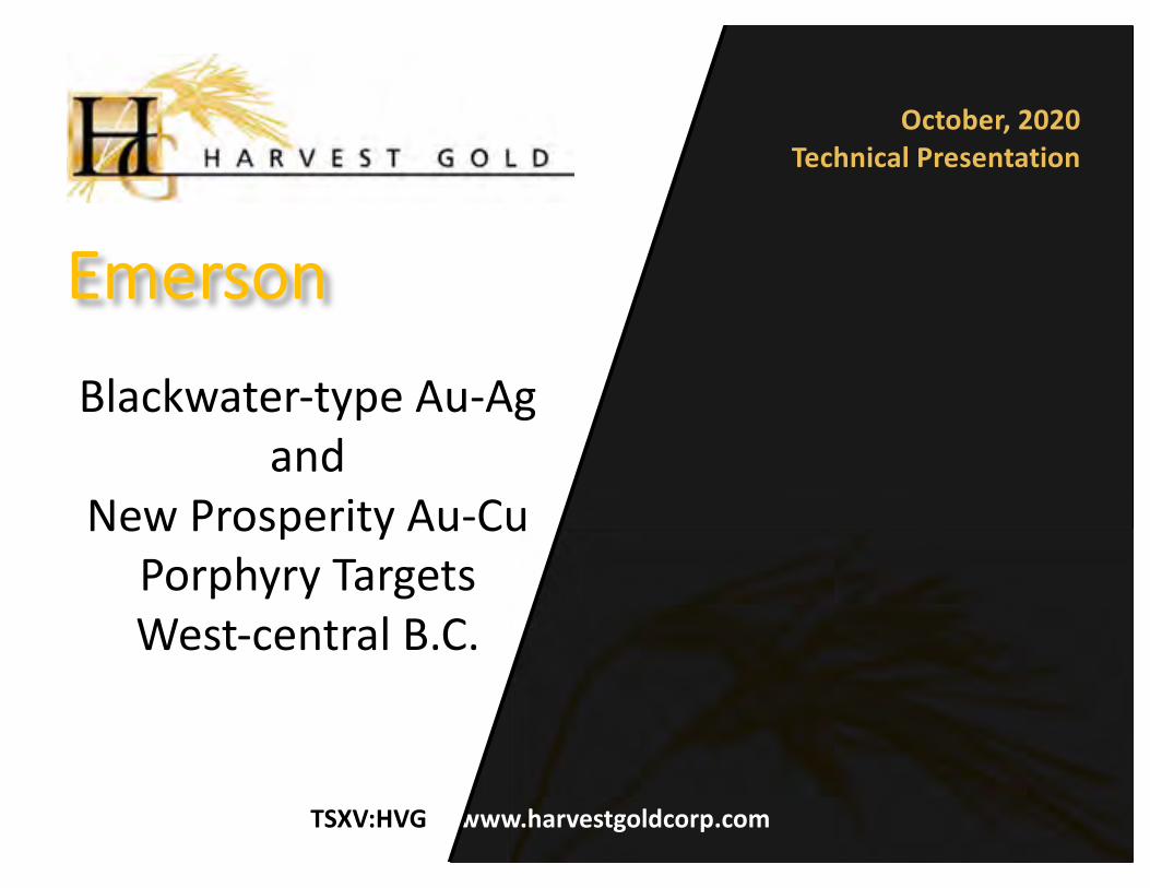
TSXV:HVG www.harvestgoldcorp.com
Blackwater-type Au-Ag and
New Prosperity Au-Cu Porphyry Targets West-central B.C.
October, 2020Technical Presentation
Emerson

Some statements in this presentation contain forward looking information. These statements address future events andconditions and, as such, involve inherent risk and uncertainties. Actual results could be significantly different from thoseprojected. Risks and uncertainties of the Company’s business are discussed in the Management Discussion and Analysisof the Company’s Annual and Quarterly Reports, available both on the Company’s website at www.harvestgoldcorp.comand at www.SEDAR.com.
A number of mineral resources or significant occurrences disclosed herein relate to nearby properties owned by othercompanies, and the data presented have been extracted from these companies’ press releases and websites. A QualifiedPerson has been unable to verify this information from the adjacent properties, and such results are not necessarilyindicative of potential quantities or grades of mineralization on the Company’s properties.
Warren Bates, P.Geo., Director of Property Investigation for Harvest Gold, the Qualified Person for this document for thepurposes of National Instrument 43-101, prepared or supervised the preparation of the technical information containedherein.Please do your own due diligence.
Forward looking information
• Good location (roads, power, railroad, etc.)• Large, strong mineralizing system (minimum 1.9 x 2.1
km; mag low suggests it could be much larger)• Most of the system covered and unexplored (marked
by chargeability high)• Only a small portion uncovered (QSP alteration, Ag-
Pb-Mo-Au soil geochemistry)• Permissive for two important deposit types:• Blackwater-type Au-Ag deposit• Bulkley (New Prosperity) Porphyry Cu-Au deposit

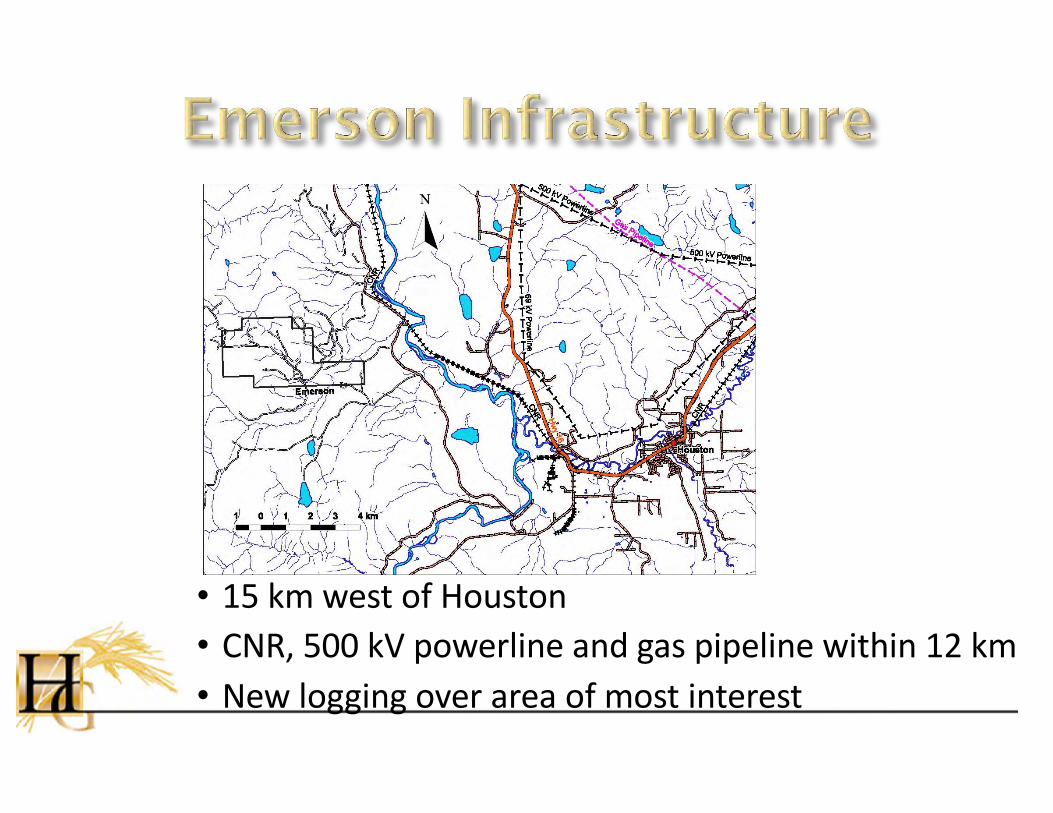
• 15 km west of Houston• CNR, 500 kV powerline and gas pipeline within 12 km• New logging over area of most interest
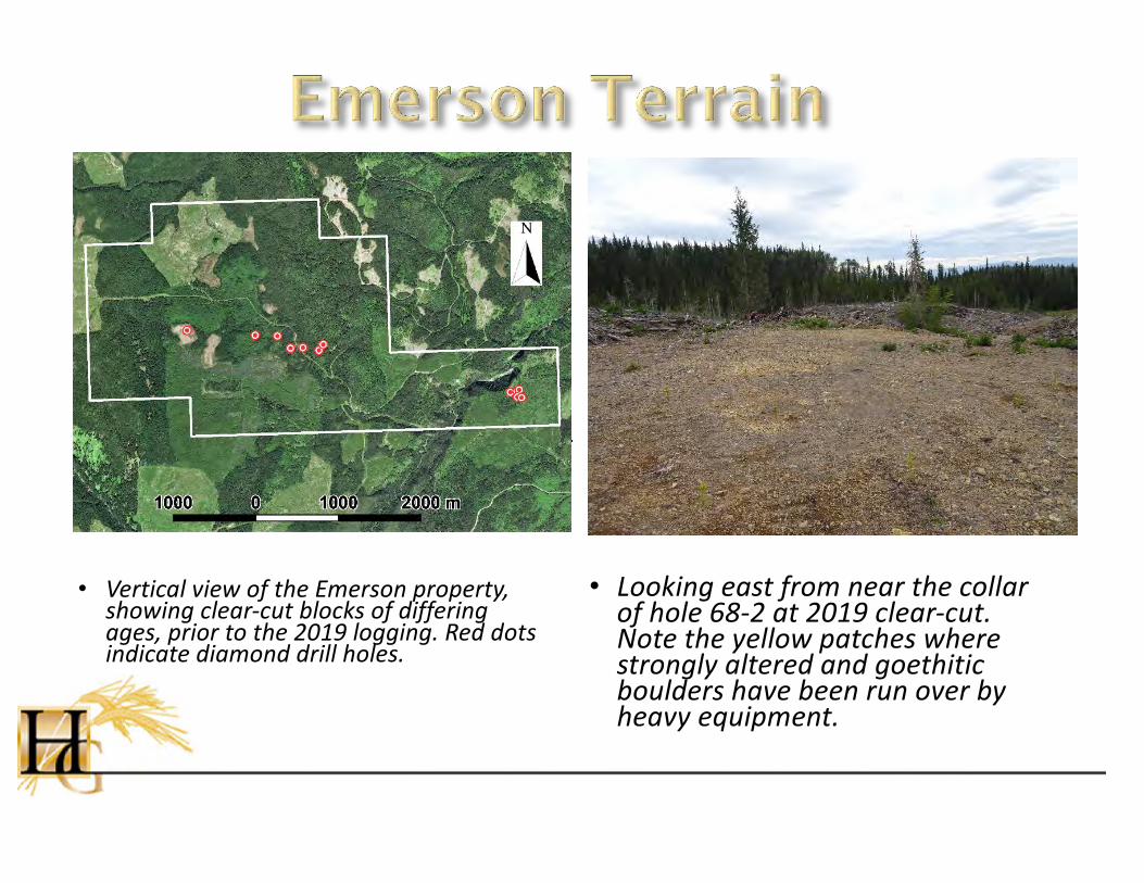
• Vertical view of the Emerson property, showing clear-cut blocks of differing ages, prior to the 2019 logging. Red dots indicate diamond drill holes.
• Looking east from near the collar of hole 68-2 at 2019 clear-cut. Note the yellow patches where strongly altered and goethiticboulders have been run over by heavy equipment.
BC Ministry of Energy and Mines
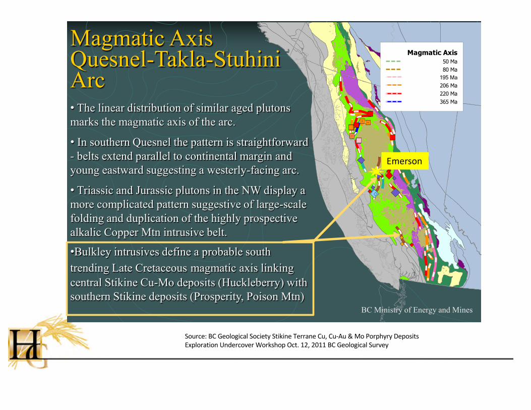
Magmatic Axis Quesnel-Takla-Stuhini Arc
Magmatic Axis50 Ma80 Ma
195 Ma
206 Ma220 Ma365 Ma
• The linear distribution of similar aged plutons marks the magmatic axis of the arc.
• In southern Quesnel the pattern is straightforward - belts extend parallel to continental margin and young eastward suggesting a westerly-facing arc.
• Triassic and Jurassic plutons in the NW display a more complicated pattern suggestive of large-scale folding and duplication of the highly prospective alkalic Copper Mtn intrusive belt.
•Bulkley intrusives define a probable south trending Late Cretaceous magmatic axis linking central Stikine Cu-Mo deposits (Huckleberry) with southern Stikine deposits (Prosperity, Poison Mtn)
Source: BC Geological Society Stikine Terrane Cu, Cu-Au & Mo Porphyry Deposits Exploration Undercover Workshop Oct. 12, 2011 BC Geological Survey
Emerson
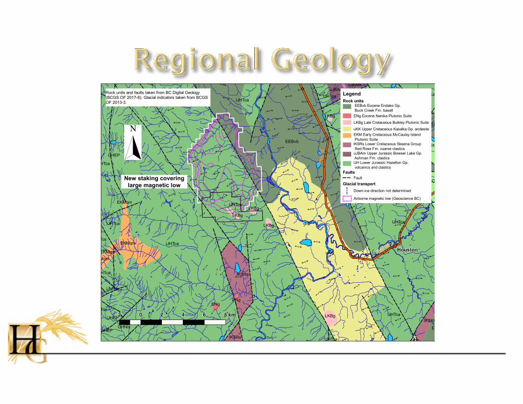
Rock units
EEBvb Eocene Endako Gp.
Buck Creek Fm. basalt
ENg Eocene Nanika Plutonic Suite
LKBg Late Cretaceous Bulkley Plutonic Suite
uKK Upper Cretaceous Kasalka Gp. andesite
EKM Early Cretaceous McCauley Island
Plutonic Suite
lKSRs Lower Cretaceous Skeena Group
Red Rose Fm. coarse clastics
uJBAm Upper Jurassic Bowser Lake Gp.
Ashman Fm. clastics
lJH Lower Jurassic Hazelton Gp.
volcanics and clastics
Faults
Fault
Glacial transport
Down-ice direction not determined
Airborne magnetic low (Geoscience BC)
LegendRock units and faults taken from BC Digital Geology
(BCGS OF 2017-8). Glacial indicators taken from BCGS
OF 2013-3.
New staking covering
large magnetic low


• Lithic tuff/volcaniclastic (Unit uKK) hand specimen. Scale card divisions in millimetres and centimetres.
• Unit uKK. Sub-rounded to sub-angular lithic fragments of volcanic rock are dispersed within a very fine-grained matrix dominated by clay. Plane-polarized transmitted light.
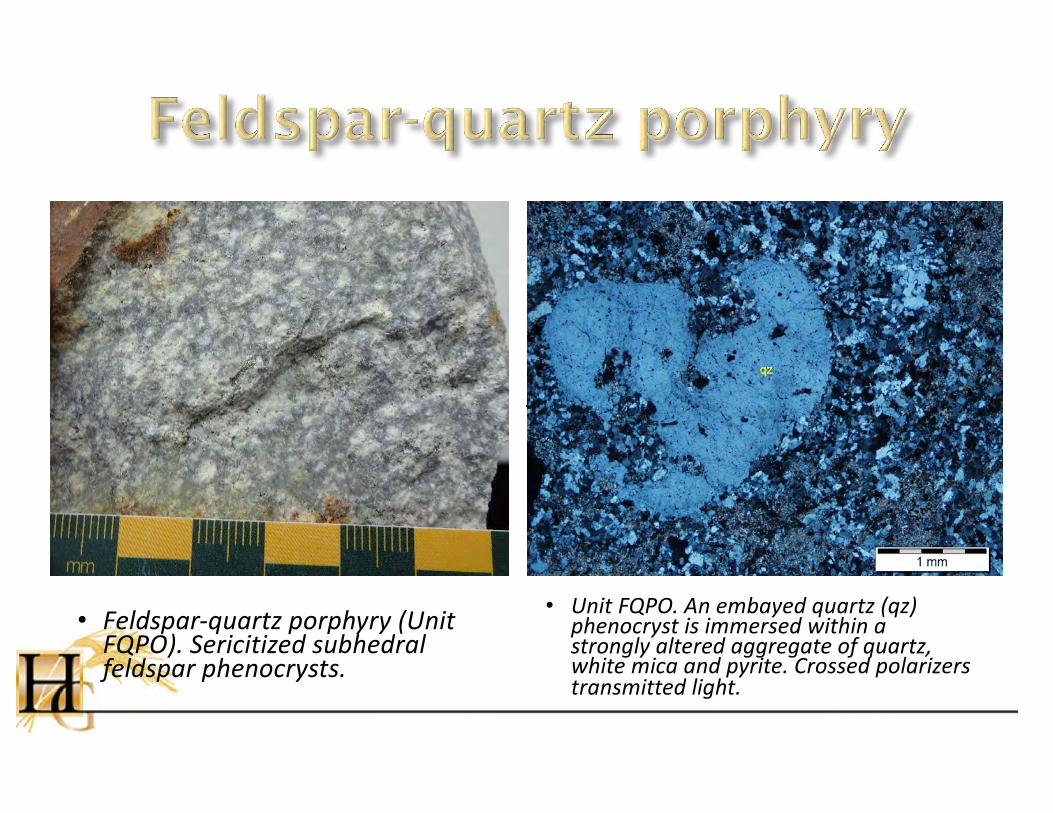
• Feldspar-quartz porphyry (Unit FQPO). Sericitized subhedral feldspar phenocrysts.
• Unit FQPO. An embayed quartz (qz) phenocryst is immersed within a strongly altered aggregate of quartz, white mica and pyrite. Crossed polarizers transmitted light.

• Extensive quartz-white mica-pyrite (QSP) alteration with gold anomalism• Quartz stockwork common• 3-10% pyrite (disseminated and in quartz veinlets)
QSP altered feldspar-quartz porphyry cut by quartz-pyrite veinlets
¨ Peripheral clay-quartz-pyrite without gold anomalism
12

• Sample 8421 (0.762 ppm Au, 236 ppm As, 71 ppm Mo). Quartz-white mica-pyrite altered volcaniclastic cut by quartz-pyrite veinlets.
• Sample 8422 (0.106 ppm Au, 183 ppm As, 137 ppm Mo). Quartz-white mica/clay(?)-pyrite altered quartz-plagioclase porphyry, cut by subparallel quartz-calcite-pyrite stringers.
13

• Sample Q932683 (0.125 ppm Au, 310 ppm Cu, 76 ppm Mo). White mica-quartz-Kspar altered plagioclase porphyry cut by quartz-pyrite-white mica-Kspar stringers.
• Sample Q932683 (0.125 ppm Au, 310 ppm Cu, 76 ppm Mo). Petrography offcut stained for Kspar (yellow).
14
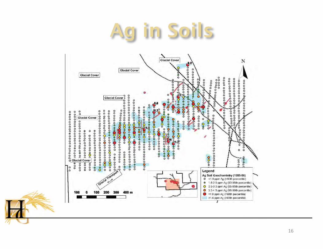
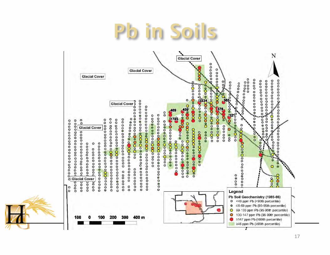
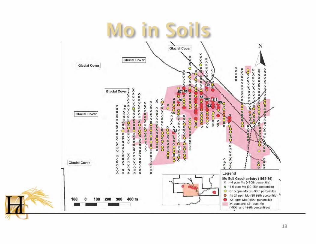
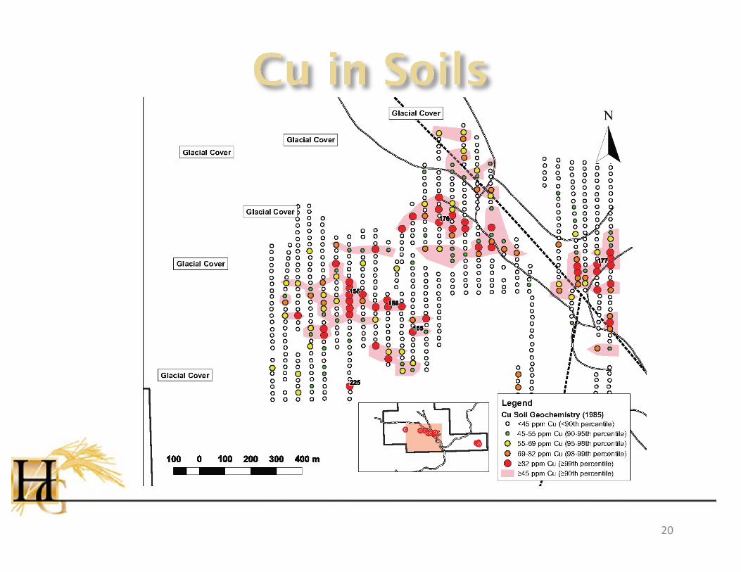
• 500 x 1,100 m Ag-in-soil geochemical anomaly (≥1.6 ppm Ag)• Coincident multi-element (Ag-Pb-Mo-Au) anomaly• Anomaly appears where till cover is thin as
demonstrated by trenches• Values tail off to SW which is consistent with
regional ice direction…glacial transport• Extensive glacial till away from trenched area,
rendering soil geochemistry ineffective
15
16
17
18

19
20
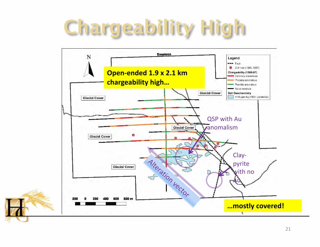
Open-ended 1.9 x 2.1 km chargeability high…
…mostly covered!
QSP with Au anomalism
Clay-pyrite with no Au
Alteration vector
21
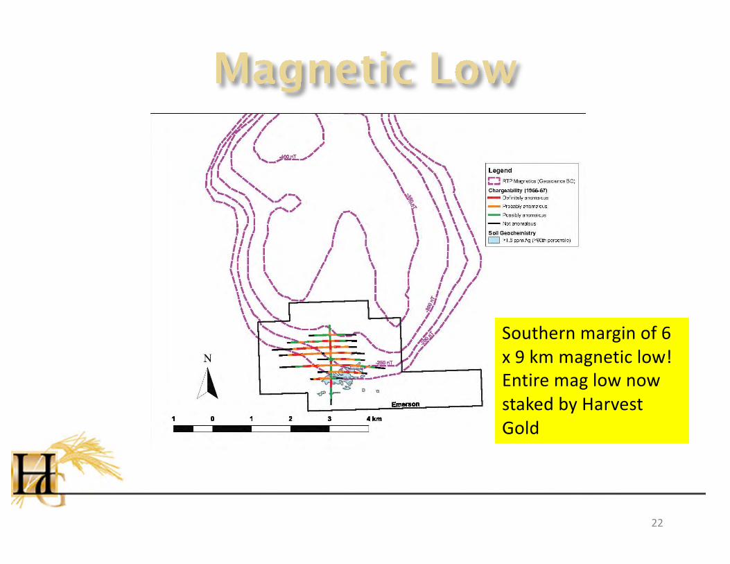
Southern margin of 6 x 9 km magnetic low! Entire mag low now staked by Harvest Gold
22

• Four shallow drill holes by Amax in 1968 intersected “extreme argillization [2019 TS indicates this is likely white mica] and pyritization” in an “intense stockwork of hairline quartz-pyrite veinlets”. Highest assays were 0.06% Cu and 0.01% Mo. No Au assays.• Lornex drilled 5 holes in 1987…2 reached bedrock.
Only EM87-4 intersected altered porphyry. Higher gold values (100-300 ppb) associated with zones containing 7-10% pyrite.• Neither drilling campaign adequately explained the
high soil values.
23

24
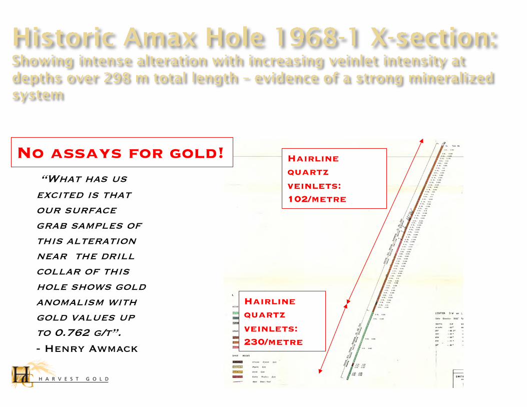
No assays for gold! Hairline quartz veinlets: 102/metre
Hairline quartz veinlets: 230/metre
“What has us excited is that our surface grab samples of this alteration near the drill collar of this hole shows gold anomalism with gold values up to 0.762 g/t”. - Henry Awmack
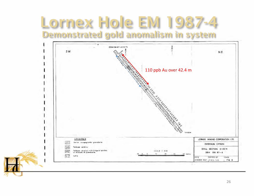
110 ppb Au over 42.4 m
26

Blackwater• Hosted by Kasalka Gp.
felsics• 66.9-72.2 Ma intrusives• Green sericite-pyrite-
quartz (main-stage ore)• Elevated Au-Ag-Zn-Cu-
Pb-As• Chargeability high
Emerson
• Hosted by Kasalka Gp. intruded by FQPO• 71 Ma FQPO• White mica-quartz-
pyrite• Elevated Ag-Pb-Mo-Au
(soils)• Chargeability high
27
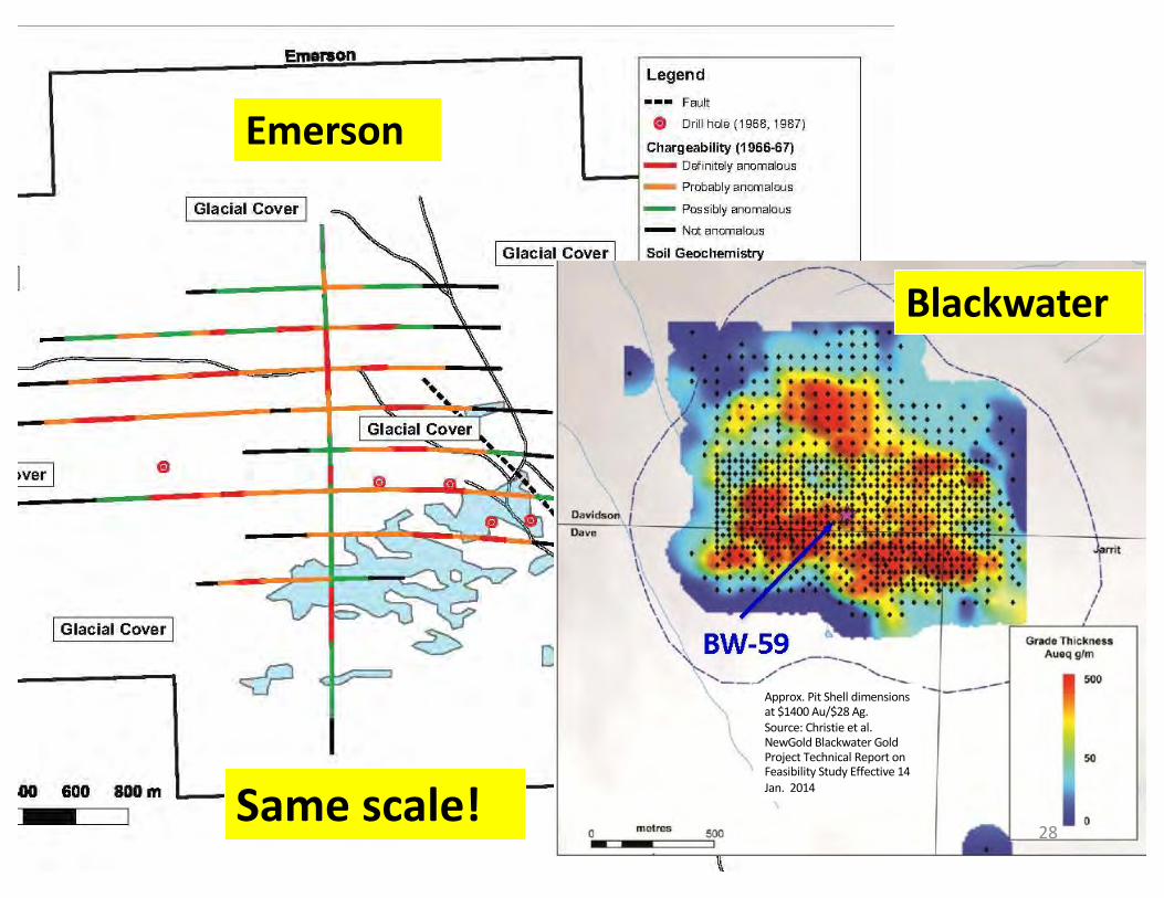
Same scale!
Blackwater
Emerson
Approx. Pit Shell dimensions at $1400 Au/$28 Ag. Source: Christie et al. NewGold Blackwater Gold Project Technical Report on Feasibility Study Effective 14 Jan. 2014
28

• Blackwater-type Au-Ag deposit:• Blackwater: 200 km southeast of Emerson• 8.0 million oz Au, 62.3 million oz Ag P&P mineral
reserves*
• Bulkley (New Prosperity) Cu-Au porphyry deposit:• Several Bulkley Plutonic Suite porphyry deposits and
prospects in vicinity of Emerson• e.g. New Prosperity: P&P Reserves of 3.6 Billion lb Cu; 7.7
million oz Au from 831 million tonnes of ore***Artemis Gold Inc. Reserves and Resources. https://www.artemisgoldinc.com/projects/blackwater-gold-project-bc-canad/reserves-and-resources/
** Technical Report on the 334 Million Tonne Increase in Mineral Reserves at the Prosperity Gold-Copper Project S. Jones, Dec. 17, 2009
The mineral resources or significant occurrences disclosed herein relate to nearby properties owned by other companies, and the data presented have been extracted from these companies’ press releases and websites. A Qualified Person has been unable to verify this information from the adjacent properties, and such results are not necessarily indicative of potential quantities or grades of mineralization on the Company’s properties.
29

Bulkley porphyry
• 61-85 Ma intrusives• Upper levels of porphyry
system overprinted by QSP• Pb-Zn-Ag-Au distal
mineralization• Pyrite halo / chargeability
high• Can have associated Cu-
Au magnetite skarns
Emerson
• 71 Ma FQPO• White mica-quartz-pyrite
(QSP)
• Elevated Ag-Pb-Mo-Au (soils)• Pyritic / chargeability
high• Associated Cu-Au
magnetite skarn
30

Same scale!
Emerson
31
New Prosperity

• Extensive mineralizing system, regardless of preferred deposit model• Boundary of target area ultimately defined by 6 x 9
km magnetic low• Small window of subcrop demonstrates system is
mineralized• Gold-bearing QSP alteration • Ag-Pb-Mo-Au soil geochemical anomaly
• 1.9 x 2.1 km chargeability high shows QSP alteration continues under cover
32

• Re-do historic IP survey and expand it, with lines 200 m apart• Test full extent of altered system• Good GPS locations• Inversions
• Detailed magnetics• Drill for Blackwater-type Au-Ag and Cu-Au porphyry
potential
33

Head Office:Suite 804 – 750 West Pender St.
Vancouver, BCV6C 2T7
Contact: Rick Mark, Pres. & CEOEmail: [email protected]
Telephone: 604-682-2928