Embed Size (px)
DESCRIPTION
ud ib small towns
Citation preview
University of Tennessee, KnoxvilleTrace: Tennessee Research and CreativeExchange
Masters Theses Graduate School
8-2014
Emergent Opportunities: Urban Design in SmallTown AppalachiaPhillip GeimanUniversity of Tennessee - Knoxville, [email protected]
This Thesis is brought to you for free and open access by the Graduate School at Trace: Tennessee Research and Creative Exchange. It has beenaccepted for inclusion in Masters Theses by an authorized administrator of Trace: Tennessee Research and Creative Exchange. For more information,please contact [email protected].
Recommended CitationGeiman, Phillip, "Emergent Opportunities: Urban Design in Small Town Appalachia. " Master's Thesis, University of Tennessee, 2014.http://trace.tennessee.edu/utk_gradthes/2817
To the Graduate Council:
I am submitting herewith a thesis written by Phillip Geiman entitled "Emergent Opportunities: UrbanDesign in Small Town Appalachia." I have examined the final electronic copy of this thesis for form andcontent and recommend that it be accepted in partial fulfillment of the requirements for the degree ofMaster of Architecture, with a major in Architecture.
John M. McRae, Major Professor
We have read this thesis and recommend its acceptance:
James D. Matthews, Mark Schimmenti
Accepted for the Council:Carolyn R. Hodges
Vice Provost and Dean of the Graduate School
(Original signatures are on file with official student records.)
Emergent Opportunities:Urban Design in Small
Town Appalachia
Phillip GeimanAugust 2014
A Thesis Presented for theMaster of Architecture
ArchitectureThe University of Tennessee, Knoxville

ii
Copyright @2014 by Phillip Geiman.All rights reserved.
iii
Acknowledgements
I would like to than my committee with the chair of John McRae and also including David Matthews and Mark Schimmenti who provided both amazing support and knowledge as well as the freedom to push out for a more uncon-ventional research. Also want to note the help of Joleen Darrah, the project manager for the Appalachia Grant, David Watson, emergency coordinator
and resident of Clay County.
-Phillip Geiman
iv
Abstract
This thesis looks at urban design within small town Appalachia and its role in low density and low resource communities.
Small towns are facing a critical juncture in this point in their history. As most areas transition from a heavy depend acne on industrial based economy to an uncertain post-industrial, they face challenges unique to rural areas. Spe-cifically, this thesis looks at “urban design” in distinctly non-urban areas and seeks to answer the question of what is the function and what is the role of
design at such a large (urban) scale.
The idea is that what distinguishes small towns from large metropolis is the rela-tionship between the designed and the emergent. Emergent in this context is defined as the aggregate of individual responses to material concerns, other words “people doing what they can with what they have” which becomes
the rule for rural areas such as Clay County Kentucky.
The design then is to identify the emerging patterns of organization and strengthen those connections to create a responsive infrastructure. This is nec-
essary because:1) there is a limit to the scope and ability of individual responses
2) the history of the context sees many projects (some with the best of inten-tions) fail to engage with the emergent process and reorganize the infrastruc-
ture and replace the context compromising its ability to self organize.
So in this particular scheme we are trying to engage with this process with a decentralized model both on the regional and urban scale. This decentralized model is defined by 1) nodes: which have a degree of self sufficiency, have a distinguishable identity but not a singular use and 2) connection: a reciprocal relationship between these point together over long distances by: the visual
encoding, physical continuity, and correlative functionality.
In answering that, this thesis hopes to rethink how traditional urban strategies spanning from regional relationships to urban plans to civic architecture work
differently in rural areas.
v
Table of Contents
CHAPTER I Introduction and General Information 1Intent Background Federal Grant Red Bird Rescue Mission ReactionsDefinitions ProposalRural Methodology
CHAPTER II Research: 8 Urban Theory and its Relationship to Small Town IssuesDistillation of Design Values Conflicting Land ValuesTheory Small Town IssuesPrecedents Distilled Design Values
CHAPTER III Context: Rethinking Regional Diagram 19Locating InfrastructurePopulation Regional AnalysisConnecting Places/Connecting SpacesRural vs MetropolitanRegional Resource Strategy
CHAPTER IV Site: Rethinking Urban Plan 35SiteRethinking Urban Plan
CHAPTER V Architecture: Rethinking Civic Architecture 42Architectural Fragments - Urban Trail MarkersFragmented StreescapesEmergent Opportunities
CHAPTER V Conclusions and Recommendations 45Evaluating SuccessOpportunities HighlightedLessons LearnedConclusion
LIST OF REFERENCES 48VITA 50
vi
LIST OF FIGURES
Fig 1. Photo of Manchester KY 1Fig.2 Red Bird Mission Cardinal House 4Fig. 3 Town design and graphics 11Fig. 4: Rural-Urban Transect 12Fig 5: Abandoned Property Manchester, KY 13Fig. 6: Kentucky Map with Clay County 19Fig. 7: Clay County Roads 21Fig. 8: Clay County Population Density 23Fig. 9: Infrastructure History 26Fig. 10: Metropolitan vs Rural Development 29Fig. 11: Three functions of rural network 31/2Fig. 12: Clay County Road Network 34Fig. 13: Manchester KY 35Fig. 14: Oneida, KY 37Fig. 15: River Street Section 43Fig. 16: River Street Fragments 44
1
CHAPTER I Introduction and General Information
IntentHow does urban design apply to rural small towns?
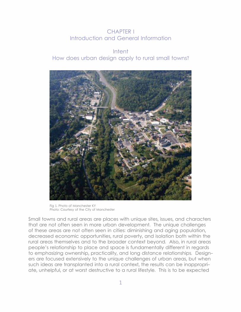
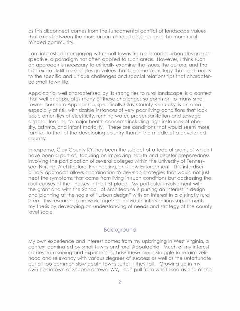
Fig 1. Photo of Manchester KYPhoto: Courtesy of the City of Manchester
Small towns and rural areas are places with unique sites, issues, and characters that are not often seen in more urban development. The unique challenges of these areas are not often seen in cities: diminishing and aging population, decreased economic opportunities, rural poverty, and isolation both within the rural areas themselves and to the broader context beyond. Also, in rural areas people’s relationship to place and space is fundamentally different in regards to emphasizing ownership, practicality, and long distance relationships. Design-ers are focused extensively to the unique challenges of urban areas, but when such ideas are transplanted into a rural context, the results can be inappropri-ate, unhelpful, or at worst destructive to a rural lifestyle. This is to be expected
2
as this disconnect comes from the fundamental conflict of landscape values that exists between the more urban-minded designer and the more rural-minded community.
I am interested in engaging with small towns from a broader urban design per-spective, a paradigm not often applied to such areas. However, I think such an approach is necessary to critically examine the issues, the culture, and the context to distill a set of design values that become a strategy that best reacts to the specific and unique challenges and spacial relationships that character-ize small town life.
Appalachia, well characterized by its strong ties to rural landscape, is a context that well encapsulates many of these challenges so common to many small towns. Southern Appalachia, specifically Clay County Kentucky, is an area especially at risk, with sizable instances of very poor living conditions that lack basic amenities of electricity, running water, proper sanitation and sewage disposal, leading to major health concerns including high instances of obe-sity, asthma, and infant mortality. These are conditions that would seem more familiar to that of the developing country than in the middle of a developed country.
In response, Clay County KY, has been the subject of a federal grant, of which I have been a part of, focusing on improving health and disaster preparedness involving the participation of several colleges within the University of Tennes-see: Nursing, Architecture, Engineering, and Law Enforcement. This interdisci-plinary approach allows coordination to develop strategies that would not just treat the symptoms that come from living in such conditions but addressing the root causes of the illnesses in the first place. My particular involvement with the grant and with the School of Architecture is pursing an interest in design and planning at the scale of “urban design” with an interest in a distinctly rural area. This research to network together individual interventions supplements my thesis by developing an understanding of needs and strategy at the county level scale.
Background My own experience and interest comes from my upbringing in West Virginia, a context dominated by small towns and rural Appalachia. Much of my interest comes from seeing and experiencing how these areas struggle to retain liveli-hood and relevancy with various degrees of success as well as the unfortunate but all too common slow death towns suffer if they fail. Growing up in my own hometown of Shepherdstown, WV, I can pull from what I see as one of the
3
more successful experiences of a small town having a degree of vitality and growth while retaining its cultural identity as “small town.” From this and other examples, successful small town design aspects include an understanding of history and social context, an acute sense of what maintains a continued livelihood, understanding of its placement as “locality” within a larger inter-connected framework of nearby other small towns, rural areas, and a broader regional area, and the simple fact being those acting also being invested in its success. It is the intersection of high-minded idealism and acute contextual understanding.
Federal Grant Supplementing this thesis, I was involved in a collaborative independent study for the Fall of 2013: Appalachian Community Health, and Interprofessional Col-laborative Practice under the direction of John McRae working from a federal grant to address health and disaster preparedness in Coal County, KY. I found this study useful in this thesis as an exercise in design in response to rural issues with the county seat Manchester, KY as the eventual site.
The first phase of this grant involves what is described as “team building proto-type neighborhood and critical infrastructure evaluation.” In this first semester the beginnings of organizing teams are being developed and the first inter-actions with the context so as to critically evaluate how to proceed in future semesters. This first semester’s focus on preliminary research was useful to continue with a more design focused interest continued form it. My interest in urban scale issues and an early stage broader county wide focus allowed for a big scale understanding that highlighted major context characteristics and is-sues of the area. The actual deliverables included research into considerations of housing, infrastructure, health, and culture detailed in a design booklet that will be used to introduce Clay County for future participants to a conceptual framework with specific interventions. Pulling from this, an outline of design issues and design principles can be developed into urban scale intervention such as a masterplan, an infrastructure plan, and a potential block typologies.
Manchester, as a site, focuses on the main downtown area, but researched in such a way that examines its connections to the larger of Clay County (and regional Kentucky). This is not just a physical study of streets but of history, culture and values, as well as the demographic, economic, and health. What was developed through this process was the more direct sense of what the re-alities of the situation entail so that proposed design responses can support the lifestyle not replace it.
4
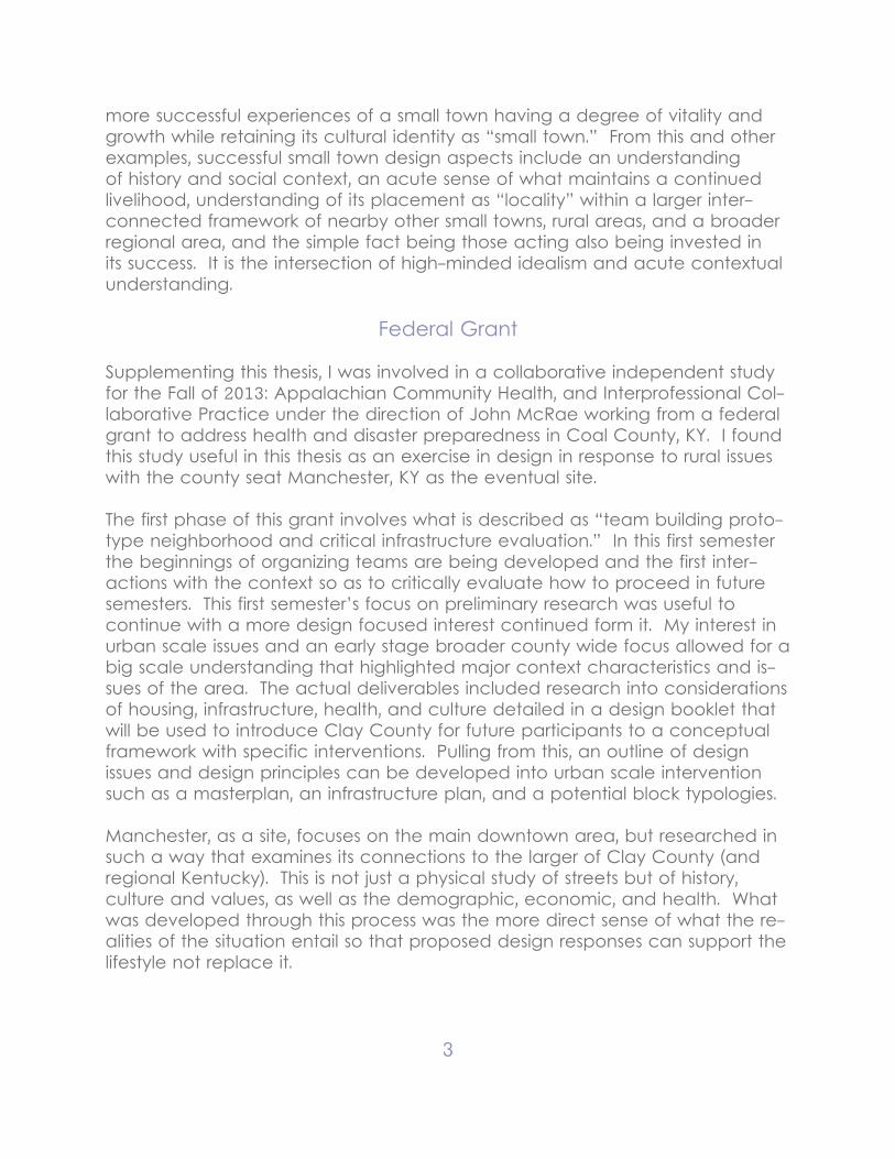
Red Bird Rescue Mission
Red Bird was main cooperative for the Appalachia project, and probably the best community connection to the most vulnerable region of Clay County. Red Bird Mission, serving the southern of Clay County and nearby Knox and Bell, is the only point of connection where people can receive assistance, health, or emergency services.
“Red Bird Mission and Clinic have been providing ministries in this region of the Appalachian Mountains since 1921. Today the need remains critical in this isolated, rural distressed area. Chronic poverty, lack of jobs, poor housing, and rugged mountainous terrain provide obstacles to a fuller life for the residents of this area. Red Bird Mission strives to meet these needs through ministry in five areas: Education, Health and Wellness, Community Outreach, Economic Op-portunity, and Community Housing Improvement.Support for these ministries come from churches and individuals across the na-tion. However, in recent years we have seen a decline in the support we are receiving. We are currently facing a financial crisis that is making it difficult to continue all the areas of ministries we provide. Without more funding today, we will have to reduce the level of ministry provided to this community. Your dona-tions to Red Bird Mission and Clinic will help us continue these vital ministries in this distressed region of Appalachia.”- Quote from their website:
Fig.2 Red Bird Mission Cardinal HousePhoto: Red Bird Mission
5
Reactions Upon the group’s initial travel to Clay County for our first real exposure to the people and the places we will be working with, my initially held notions of what is the role of a designer and the role of a design were heavily rethought in relation to both this project and this context. Contemporary urban theories of “New Urbanism” and “Transit Oriented Development” are strategies that are meant to respond to needs and abilities of more metropolitan areas: problems associated with suburbanization and urban blight and resources such as public infrastructure and networked transportation. The strategies then become gen-erally focused on urban consolidation to densify development at urban cores in attempt to leave little impact of rural areas.
However in Clay County, the problems to be addressed and resources to pull from are completely different. Communication, difficult landscape, and chron-ic poverty were major challenges to a very vulnerable livelihood. Suburban sprawl is hardly the issue at hand and the expected resources usually pulled from such things as infrastructure, assumed growth, and capital investment are extremely limited.
In this way, planning and design need to work as an agent of community im-provement focused not on principles of form but on principles of subsistence with its strength being the ability for cooperative engagement with other pro-fessionals (design and otherwise) and those community members who will be most affected by interventions. Precedents of this design philosophy such as the “Rural Studio” or the “Small Town Center” see the role of a planner as an organizer, not a master planner for the community. To see a big scale coordi-nation plan with if specialized parts in a way that is comprehensive and men-tions all critical areas is crucial to implementation and success.
Definitions
Emergent- the aggregate of individual responses to material concerns, - “people doing what they can with what they have.”- reactive | responsive | material -logical responses to economic, site, and social realities
Designed- form driven from abstract concepts such as 1st principles, organization of mass production, or artist’s creative id- proactive | planned | abstraction
6
Node- point of intersection within a larger network- which have a degree of self sufficiency- have a distinguishable identity but not a singular use
Connection- a reciprocal relationship over long distances by:the visual encoding | physical continuity | correlative functionality.
Infrastructure- organized structure facilitating the operation of a society or enterprise
Self Sufficiency- Ability to sustain an activity and livelihood independent of larger systemseconomic | environmental | individual
Proposal
My proposal is one in which these disenfranchised rural areas become the center of this study both as a matter of design and a matter of methodology. Those concerns specific to the context is comprehensively studied as a matter of rural issues and cultural values and used as generators for design decisions. Designing on an urban scale, these issues puts these creations specifically through the lens of “small towns,” focusing on how those issues can develop a set of values to drive the design strategies.
The conventional urban framework of large central city and suburbs connect-ed by infrastructure is not feasible for this area. What can be developed is a decentralized node network that connects the larger clusters of rural houses to more to isolated areas. In this way, the site is not insular but rather engaged in reaching out to the greater rural region. This will facilitate interactions between formerly isolated places and address the major obstacles of communication and access. Consolidation is not goal of more dense areas facilitating on the creation of individual moments, but as network nodes and intersections of dis-parate areas.
What will be studied both to research is the relationships of 3 levels: county (single and comprehensive), regional (intermediary zones breaking up Clay County), and neighborhood (size of small towns and “hollows”). This study includes systems of infrastructure (power, communication, roads), lay-out of resources (water, shelter, capital), networks of institution (school, health,
7
church, missions), and fabric of culture (neighborhood/holler, community inter-actions). The relationship between small and big scales can be mediated by 3 relationships: extension (from central to remote), access (between the remote areas) and independence. In most of these cases, this mapping analysis works as both research: how does the map exist, and how can it be improved.
Rural Methodology
So the design of this thesis functions as the means to explore how typically urban design methods can be transformed into better addressing specific rural issues and site. Then, exploring design in three phases work at three different scales usual for urban design: regional, urban, and architectural.
Research: Urban Theory and its Relationship to Small Town Issues
Context: Rethinking Regional Diagram: Urban Methodology: New-Urbanist Transect - Emphasizes density and compactness. The city as absolute centerRural Transformation: Decentralized Network Emphasizes the connections and mutual reciprocity of towns and villages
Site: Rethinking Urban PlanUrban Methodology: Master Plan Uniform and enforced. Zoning and specializationRural Transformation: Node Anchors Catalysts for activity and roughly planned. Identity with diversity.
Architecture: Rethinking Civic SpaceUrban Methodology: Unified Streetscape Formal, grand, uniform, large scaleRural Transformation: Fragmented Sequence Vernacular, personal, ambiguous, natural
8
Chapter II:RESEARCH: URBAN THEORY AND ITS RELATIONSHIP TO SMALL TOWN
ISSUES
Distillation of Design Values
Potential new developments have the opportunity to react to unique charac-teristics and strengths of a rural site, but must confront the inherent issues that pose a challenge to small town livelihood. In this section research for this thesis looked how “small towns” are thought of and planned in three main ways:
Theory:An examination of urban theory in its relation to rural small towns
Issues:Research into those small town issues (not explicitly architectural) that may ap-ply to a design project
Precedents:Examination into design work in rural small town areas
Each of the areas of this research conclude with identifying specific values, recommendations, or other info of note so as to distill a small set of values that can inform a design philosophy applicable to both overall strategy and spe-cific decisions.
Conflicting Land Values
This issue raises the major potential problem regarding land values between those on the planning side and those on the residential side. The relation that one has to the landscape as designer, and relation one has as homeowner leads to acute but differing intuitive understandings that, if handled poorly or unevenly, is disastrous to cooperative efforts. Designers, planners, and profes-sionals coming from a background of education and specifically do not live or have any background history in specific areas of interest come with an ap-proach that is abstract and technical. However, lack of a more concrete and nuanced understanding of the daily realities and the perspective of how such proposals would fit in with context and function leads to completed construc-tion that is detrimental when introduced to the community. The threat is, plan-ners try to “impose” solutions in a condescending manner (without taking the input of residents) and can run the risk of becoming inhumane, destroying the contextual livelihoods of the residents and/or being rejected outright, utterly

9
failing at its mission of community engagement. Appropriate solutions are not given by specialists but developed as part of a cooperative engagement.
The example of this well intended misfire could be the “Make it Right” non-profit organization intending on rebuild the destroyed lower ninth ward of New Orleans. Seeing little progress in the years after Hurricane Katrina, Brad Pitt founded this organization that was able to raise a lot of money and a lot of architectural talent to build 90 ultra--modern single-family residential houses. Beyond simply putting too much money into two few houses, the project radi-cally reinterpreted the formal context to the point were it simply failed to ad-dress what the neighborhood needed and why people chose to lived there in the first place.
“Pitt’s foundation could have chosen to put its money into a neighborhood where the compounding effects would’ve been remarkable, or at least one without the added risk and cost of building below sea level. He could also have built several hundred perfectly serviceable, weatherproof, and efficient new homes, instead of the 90 he’s completed—like Barnes and Noble founder Leonard Riggio, who’ll build 200 new homes in a concentrated area in nearby Gentilly for about the same amount. He could even have filled in more quickly recovering neighborhoods with higher-quality traditional designs, like New Ur-banist patron saint Andres Duany. Instead, Pitt got an interesting architectural experiment, lots of gushy magazine coverage, and a place for Gloria Guy to remember what life was like before it all floated away.”
- “If You Rebuild It, They Might Not Come” Lydia DePillis
The population that had been there did not move back, because the people did not see this as an improvement to but as a replacement of the neighbor-hood they had lost. Instead who was attracted to this new neighborhood were the trendy who could afford what the developers and designers brought with them. Despite the best of intentions, the Ninth Ward remains as lost as before but with the added of antagonism of the locals being antagonized by a developer who pushed out a vulnerable community.
John Seabrook, culture critic for the New York Times, notes the inherent soci-etal division that generate the division a of culture into Highbrow and Lowbrow as coming from a societal division into upper class and lower class. Such di-vision, he theorized in postwar 1950’s, would disappear as globalization and democratization emphasized equality in a more progressive society devoid of such strict division. His imagining of “Nobrow” is a theory of a universal homog-enized culture created and enjoyed by all. However, in the later half of the 20th century, the universal mass culture fragmented into a series of “taste cul-
10
tures.” This created a representative of the strength of smaller subcultures cre-ating identities that were unique to each and in opposition to a mass culture. In particular, the development of a “creative class,” of which architects and other designers embodied, define themselves as their tastes in art and design, appreciating the avant-guard and modernist sensibilities.
This becomes problematic when designers (informed by their own tastes) pur-sue projects in cultures that are rural, impoverished, or in general don’t share the same values. Appalachia as a subculture is found to have values that are quite different that those of the urban and educated. Moreover, Ruby Payne, in her “Framework for Understanding Poverty” outlines that socio-economic classes themselves (upper, mid, or lower) affects the paradigm that one sees the world and one’s place in it. Thus, architects, being middle class and rep-resenting that paradigm, will value education and abstract thinking, while the potential clientele of Clay County, being disproportionately but not exclusively from low resource conditions, will value concreteness and practicality. To op-erate effectively means to recognize one’s own tastes and biases as not uni-versal so as to prevent imposing ones own values on a population which many not reciprocate. Design has the potential to be antagonistic and exclusive if not responsive to needs and wishes of a community, (which are common cri-tiques of Modernist and New Urbanist theory).
This project, one that wishes to be especially responsive with community well-ness, seeks an engagement with the central dilemma being of those with con-flicting land values. Because of this, extensive effort has been made to distill the values and tastes, a critical examination of culture and context so as to build design and planning solutions that are inclusive gestures. This outsider status embodying my own biases is not one that can be overcome in one semester with one project. None the less, to explore that central issues at the outset through theory and research is one way to hopefully develop a meth-odology that is acute and responsive. So to engage and not to impose means design must be generated from the concrete needs and realities of site neces-sitates critical examination of those issues to determine a set of design values to inform responsive design.
Theory
This sections explores historic urban theory and its reponses to the rural environ-ment.
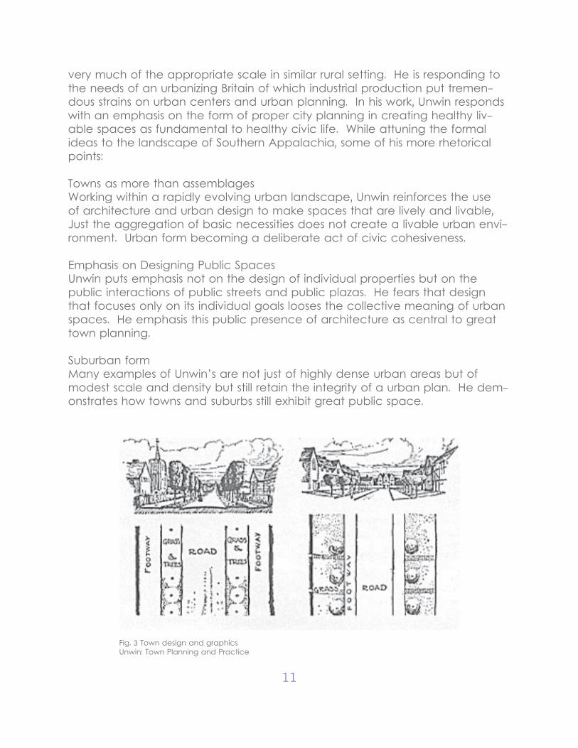
Architecture as Civic artRaymond Unwin, English engineer and town planner, in his piece “Town Plan-ning and Practice” in 1923 details the formation of small scale urban design
11
very much of the appropriate scale in similar rural setting. He is responding to the needs of an urbanizing Britain of which industrial production put tremen-dous strains on urban centers and urban planning. In his work, Unwin responds with an emphasis on the form of proper city planning in creating healthy liv-able spaces as fundamental to healthy civic life. While attuning the formal ideas to the landscape of Southern Appalachia, some of his more rhetorical points:
Towns as more than assemblages Working within a rapidly evolving urban landscape, Unwin reinforces the use of architecture and urban design to make spaces that are lively and livable, Just the aggregation of basic necessities does not create a livable urban envi-ronment. Urban form becoming a deliberate act of civic cohesiveness.
Emphasis on Designing Public Spaces Unwin puts emphasis not on the design of individual properties but on the public interactions of public streets and public plazas. He fears that design that focuses only on its individual goals looses the collective meaning of urban spaces. He emphasis this public presence of architecture as central to great town planning.
Suburban form Many examples of Unwin’s are not just of highly dense urban areas but of modest scale and density but still retain the integrity of a urban plan. He dem-onstrates how towns and suburbs still exhibit great public space.
Fig. 3 Town design and graphicsUnwin: Town Planning and Practice
12
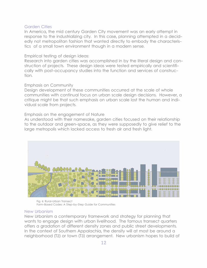
Garden CitiesIn America, the mid century Garden City movement was an early attempt in response to the industrializing city. In this case, planning attempted in a decid-edly not metropolitan fashion that wanted directly to embody the characteris-tics of a small town environment though in a modern sense.
Empirical testing of design ideas:Research into garden cities was accomplished in by the literal design and con-struction of projects. These design ideas were tested empirically and scientifi-cally with post-occupancy studies into the function and services of construc-tion.
Emphasis on Community Design development of these communities occurred at the scale of whole communities with continual focus on urban scale design decisions. However, a critique might be that such emphasis on urban scale lost the human and indi-vidual scale from projects.
Emphasis on the engagement of NatureAs understood with their namesake, garden cities focused on their relationship to the outdoor and green-space, as they were supposedly to give relief to the large metropolis which lacked access to fresh air and fresh light.
Fig. 4: Rural-Urban TransectForm-Based Codes: A Step-by-Step Guide for Communities
New UrbanismNew Urbanism a contemporary framework and strategy for planning that wants to engage design with urban livelihood. The famous transect quarters offers a gradation of different density zones and public street developments. In the context of Southern Appalachia, the density will at most be around a neighborhood (T2) or town (T3) arrangement. New urbanism hopes to build of
13
the lessons and traditions of successful urban designs applicable in a variety of conditions and designs.
Emphasis on Density:The emphasis on density may be understood as in response to suburban sprawl, which is not an immediate concern of rural typologies. However, density also serves a purpose in creating a “critical mass” in which neighborhoods and urban centers have enough population and concentration of services to be-come destination points.
Humanism in designIn response to the at times dehumanizing tendencies of impersonal urban de-sign, New Urbanist thought puts more emphasis on design in response to com-munity needs rather than as social engineering. A cooperative engagement that respects the wants of the citizenry and the freedom of the individual
Generating flexible design conventionsThe design solutions developed within New Urbanism, while specific enough to address street face concerns, are flexible enough so that such designs do not dictate the decisions of individual building projects
Small Town Issues
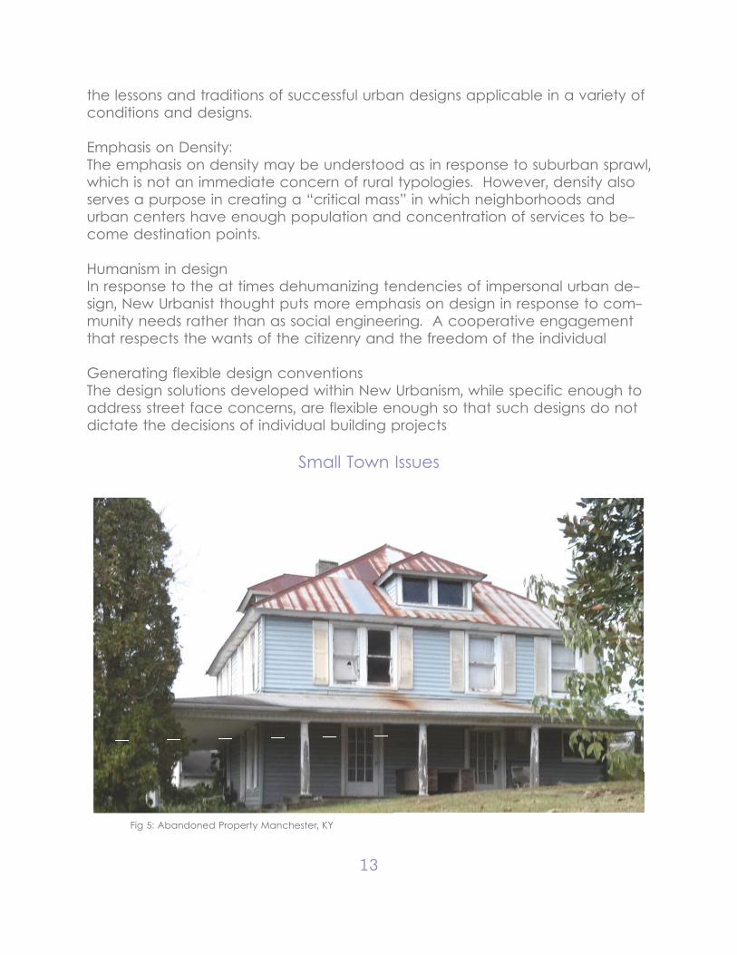
Fig 5: Abandoned Property Manchester, KY
14
Small Town Exodus:Challenges facing small towns are diverse, the central issue which is both cause and effect of many challenges is a population decline from small towns. Key portions of the demographic of small towns, (young, educated, ambitious,) leave small towns to seek greater opportunities in metropolitan areas. This causes an economic and brain drain of these areas visibly seen as businesses close, properties vacate, and tax bases dry up. A self feeding cycle causing areas and infrastructure to age and struggling to maintain the lives and liveli-hoods further frustration future opportunities. This lack of modernization further causes isolation from the resources much needed and a disconnection from the wider world.
“In 1910, the rural population of our country was about 32 million; by 1970, it had fallen to just over 9 million. In the late 1950’s and early 1960’s, only 40% of those born in rural America still lived in rural America, and there seemed little doubt that this exodus from the countryside to the city would continue. Why the flight? The attractions of the city life played a part, of course, but a more fundamental motivation was economic, for changes in agricultural technol-ogy created a huge pool of under-utilized labor for which the future was bleak indeed. The young left, as did the educated and the adventurous, and many of our small towns were turned into hollow shells with chronic fiscal crises and rapidly aging populations. Small towns came to be seen as a kind of residual category, a rapidly fading anachronism in a world transformed by urban pro-cesses.”
- Robert E. Tournier “Small towns at the Crossroads.”
It is this major issue that is fundamental and distinguishes “small towns” from urban areas. Cities struggle with population growth, towns with population decline. Gaps are created as the structure ages and fractures. What design thinking has the ability to do then is to more intelligently address these issues in a comprehensive manner fill the gaps and seize opportunities in creating en-gaging spaces that retain their identity.
Potential developments in non-metropolis areas:Mildred Lumis notes the potential opportunity in rural areas, both as the de-velopment of technology can eliminate barriers of isolation. Technological advancement like cell phones and internet allow easier communication with-out much of the heavy and expensive infrastructure. Transportation is better facilitated meaning that the remoteness of rural places does not have to be isolated therein maintaining the connections between rural areas and each other, and rural areas to distant urban areas. Digital technology also allows easier access to entertainment and education, key aspects to both comfort-
15
able livelihood and economic development.
Lumis also notes a renewed appreciation for the inherent strengths of rural ar-eas that can make them appealing destinations.
- Relief from density of city - Connection to outdoor recreation- Self-Sufficiency: growing own food/ generating own power- Desire to return to the land
In this way rural areas have the potential to be new areas of growth and de-velopment as rural living becoming more feasibly connected to modern area and design has the opportunity to showcase these inherent strengths
“So, starting only a couple of years ago, the movement of people from the country to city stopped. Then to the surprise of experts and people -watching and head-counting, the tide of the population growth swung the other way, reversing a historically entrenched trend. The fastest population growth at least in percentage points was in some of the most remote and formerly attractive areas:
Four areas now attracting the highest percentage of growth are:1. Eastern Kentucky and the Southern Appalachian Region. The energy situ-ation plays an important role here. Coal areas are again becoming island of prosperity, but that’s not the whole story.”
- Mildred Lumis “Rural revival on its way.”
Enough access to free energy - sun, wind, and water - to make alternate en-ergy sources work effectively. Intensive scientific effort will be directed in those areas to yield results for small scale application. .... Improved electronic technology, which in a gentle way will help rural homesteaders and farmers stay in tough with the world. While retaining the freedom of movement and the pleasures of working in the open air, rural people will have access to the best education and entertainment. ... The autonomous house, the true self suf-ficient homestead.
- Mildred Lumis “Rural revival on its way.”
Poverty as a ParadigmEspecially with the use of Clay County, KY as a point of study, poverty be-comes a large issue in need of redressing. For the purposes of distilling how to engage with Low Resource Conditions, Ruby Payne approaches the issue in her Framework for Understanding Poverty.
16
In order to act without judgment or condensation, you must recognize how one’s experience living in upper/middle/or working class environment affects ones values. Since architects often represent the middle class sensibilities, these are not always appreciated in low-resource conditions and would be inappro-priate to try to impose one’s values through design or action. Payne highlights several values that are relevant to respond to as designers:
- Concrete reality over Abstraction- Survival as Priority- Emphasis on personal relationships as network- Preferring the Casual over the Formal- High regard Land/Property ownership - Low emphasis on education
PrecedentsCarl Small Town Center:In an interview with John Poros, who heads the Carl Small Town Center, John discusses strategies that the center uses to best engage with a rural and at times impoverished clientele so that planning and design can be a benefit.
- Design is not the priority to make projects successful. Research and interac-tions with the community are such big drivers that the specific design is a small portion of the overall time involved. This is good to hear as I was anticipating a great degree of the grant project as a whole and my part within it to be heav-ily research based.
- In his experience community engagement is paramount with often com-munication. He put great emphasis on the application form that all potential projects go through a more formal means for potential communities to orga-nize their ideas for projects and present them emphasizing the organization on the community side. In this way the STC has a concrete form directly from the community where what is needed and a frame work of how the community side can be involved. As he mentioned, in some cases projects, a design cen-ter is not needed, just an architect.
STC Application Questions:-Community History-Economic Base-Unique Characteristics- Assets and Problems-Historic Districts/Landmarks-Problems that need to be addresses
17
-How Design can assist-Community Organization-Role of Community/Role of Professional-Barriers -Resources Available-Publicity
Chris King:Interview with Chris King in successfully designing in Appalachia
Chris King, practicing architect with much experience growing up and practic-ing within Appalachia, shares his principles to successfully engaging with the culture
-Studying Vernacular Architecture:To understand the unique vernacular aspects of a particular region not so it can be emulated in a sentimental way, but to take advantage of local wis-dom.
-Studying Terrain/MicroclimateMountainous terrain makes drastic impacts on sunlight and water drainage which can lead to issues of mildew and mold. Typologies that originate in more flat environments (ranch style) are totally inappropriate in such conditions. Flatland is at a premium so buildings are often constructed into the hillside.
-Discerning Social ValuesMockbee “architects are in the best position to affect social values.” If you do not attune design to social values it will not be accepted. This does not mean it has to look like its context but it must resonate with its values. A visual form that is very much in tune with what it needs to be.
-Addressing a Sense of OrderIn lower economic conditions, residents don’t want to feel more disorder. Strong, straight, and permanency are the often necessary characteristics.
-Architecture as a Humanitarian GestureThe most important thing is to serve people and allow architecture to reach the rest of the world.
18
Distilled Design Values
After researching the different paradigms of the values representative of dif-ferent in both urban theory and small towns, this sections picks out a few key values and how they can be used to inform design strategies.
Distilled Research ValuesThe first part of the project involved research into small town and rural issues and what are the urban responses to them. Distilled from these works of theory and precedents four main values to drive strategies and design decisions:
- Understand Importance within a larger networkThe urban plan should be understood and facilitate it’s existence within an more regional context. This can go beyond physical construction, but geo-graphical context and a cultural context.
- Social Values as a driver of form.The main generations of design decisions is context and communities. The em-phasis of design as agent of community health and improvement places ap-propriateness and engagement as high priorities. Personal or theoretical ideas that direct design decisions need to be constantly checked against the social values.
- Retain the Importance of NatureThe strength of small town and rural areas is their connection to the land. This connection can be made at both an urban and individual level
- Engagement with the economic realitiesIn order to retain viability the project must at some level engage with the eco-nomic realities of poverty and low resource. This does not have to be a limita-tion but an opportunity to engage with a different set of design strategies and sensibilities.
Design Strategies- Decentralized Node Network as Regional Framework- Engagement with Community- Abstract Theory demonstrated through Concrete Design- Contextual Design growing directly out of Site Analysis- Stimulate new Development- Development that is appropriate (don’t cannibalize)- Project without large capital investment (series of modest projects that reflect a greater effort)
19
CHAPTER III CONTEXT: RETHINKING REGIONAL DIAGRAM
Locating
Rural MappingThe most defining aspect of Appalachian context is the land, the physical land, an entity that shapes peoples lives and how they interact with each other. The ancient mountains, primordial forests, and pure streams drive a deeply en-trenched rugged history characterized by rural independent livelihood. There are no large cities, massive infrastructure, dense population, or rampant com-mercial activity that so mark modern urban living. This is modern rural living, that may be quite different from the more romantic Arcadian misconceptions and is affected by the challenges of aging, diminishing population, post indus-trial economy, and rural poverty. Any possible future initiatives need to under-stand and react to that landscape.
This first section attempts to give a 10,000 ft. perspective over the entirety of Clay County including what is there, where people live and why. Focusing on land, infrastructure, population, resources, and at the end, some conclusions may drive potential projects. Even this perspective can be gleamed strengths, issues, and potential solutions for action.
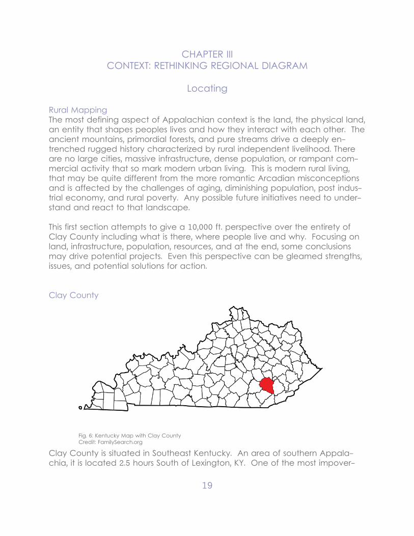
Clay County
Fig. 6: Kentucky Map with Clay CountyCredit: FamilySearch.org
Clay County is situated in Southeast Kentucky. An area of southern Appala-chia, it is located 2.5 hours South of Lexington, KY. One of the most impover-
20
ished areas, City Data reports that around 40% of the population lives under the poverty line with 15% below half the poverty line. While poverty is a prin-ciple issues, it is also worth noting that a large percentage of houses units are trailers with many in poor conditions.
The population of 21,000 in an area of 470 square miles notes a mostly rural population (80%) and a notable population drop. Also notable is the lower rates of education, all of which are representative of the small town issues that have been noted prior.
Info At a Glance County population in July 2011: 21,720 (21% urban, 79% rural); it was 24,556 in 2000
Land area: 471 sq. mi.Mar. 2012 cost of living index in Clay County: 82.3 (low, U.S. average is 100)
Current college students: 518People 25 years of age or older with a high school degree or higher: 49.4%People 25 years of age or older with a bachelor’s degree or higher: 8.0%
#17 of “Top 101 counties with the most Evangelical Denominations adherents”
Residents with income below the poverty level in 2009:This county: 39.7%Kentucky: 15.8%
Residents with income below 50% of the poverty level in 2009:This county: 14.9%Kentucky: 6.6%
number of grocery stores: 4This county: 1.68 / 10,000 pop.Kentucky: 2.19 / 10,000 pop.
Number of full-service restaurants: 3Clay County: 1.26 / 10,000 pop.Kentucky: 5.74 / 10,000 pop.
Households: 19,490
Housing units in structures: One, detached: 5,824
21
One, attached: 34 Two: 141 3 or 4: 202 5 to 9: 145 10 to 19: 48 20 or more: 107 Mobile homes: 2,932 Boats, RVs, vans, etc.:
Infrastructure
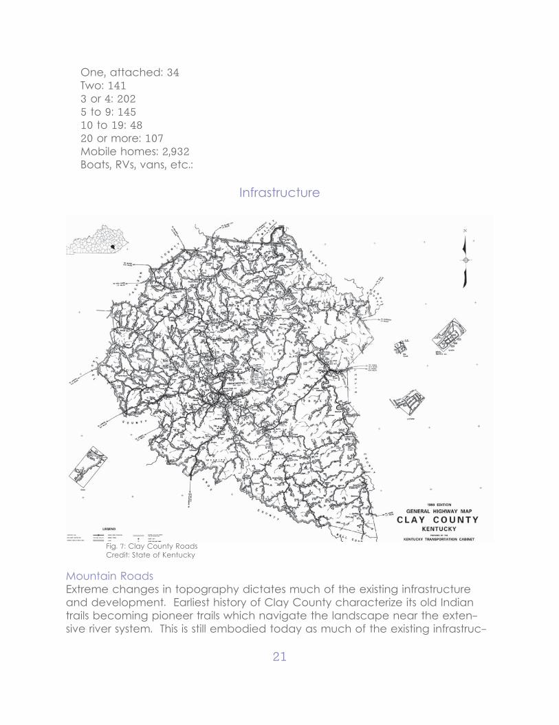
Fig. 7: Clay County RoadsCredit: State of Kentucky
Mountain RoadsExtreme changes in topography dictates much of the existing infrastructure and development. Earliest history of Clay County characterize its old Indian trails becoming pioneer trails which navigate the landscape near the exten-sive river system. This is still embodied today as much of the existing infrastruc-
22
ture (roads, rail, power lines) still group together around the river/creek system. This tends to be problematic as movement around the county roads can be treacherous, especially when compromised during floods, storms or other natu-ral disasters.
Also, noting the large area of Clay County, the limited highway systems elon-gate already extensive travel distances. For example to travel from Red Bird mission in the southern part of the county to Manchester in the center of the county is 40 minutes, with similar times to the other unincorporated towns.
The wildly extreme topography dictates the wildly extreme road network that crosses Clay County. Infrastructure utilizes whatever flat ground it can find or digs it out of the mountain with great effort. There is no large flat interstate coming through this area, with transportation consisting entirely of winding and dangerous country roads that are the lifelines between a majority rural popu-lation. Places are far removed from one another and distributing any goods over a large area exponentially difficult because of the decentralized popu-lation. Many roads are in good condition but others can be unmaintained, unpainted, and unpaved, and many of which can be rendered impassable with severe weather, effectively stranding people in their most vulnerable times. Many hollows have only one way in out and the only hospital is at risk of flood-ing. These country roads are the tenuous thread that keep life together in Clay County.
Industrial HistoryThe mineral industry has historically been the largest industrial driver in Clay County. Earliest settlers made a majority of livelihoods through fur trapping and timber before being replaced by the early salt works in the 1800’s. This indus-try created the small towns such as Manchester and Goose Rocks before be-ing interrupted and then ultimately destroyed by the Civil War. Extensive coal mining in Clay County, also involving nearby Leslie and Hazard, soon became the main economic engine for the area. Major infrastructure such as railroads, power lines, and highways were built to serve this activity. However, coal min-ing itself is incredibly dangerous work and environmentally destructive such as with mountaintop removal and water pollution. Coal mining shifts the econo-my away from subsistence agriculture to industrial wage meaning that funda-mentally people are not working off of the land to make food and materials for themselves but are making money at a job to then buy those necessities. In recent times, the coal mines have shut down almost entirety and, though a potential future in hydrofracking is talked about, the future is wildly uncertain as to how people are going to make a life for themselves. Residents now lack most of the skills that would make them competitive in a modern economy and/or lack the substantial initial capital for investment all the while still deeply
23
affected by the ecological damage and economic hole left by coal mining. Poverty, welfare, and drugs then come to fill the void.
However, extensive land ownership, emphasis on self reliance, and a culturally tight, though physically distant people do provide great strengths that can be built off of as we try to help these people make a better life for themselves. How can one use the strengths to intelligently address the realities of rural pov-erty?
Population
RedBird Missions
Clay co
Bell Co
Knox co
Laurel co
Jackson Co
Owsley Co
Perry Co
Breathitt co
Leslie co
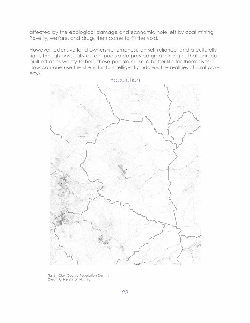
Fig. 8: Clay County Population DensityCredit: University of Virginia
24
Hollows and TownsClay County is mainly rural, where 80% of the total 21,000 population that live here. There is no suburban sprawl but there are hollows, a quasi-communal family community of multiple houses and structures built close to each other. This comes from extensive land ownership that is divided up and passed down through the generations as families age and grow. This creates very tight-knit and at times, reclusive communities that live far off major roads. Some can be well off and others can be poor but this close living arrangement reinforces close familial connections.
While more populous towns like London or Annville in the adjacent counties to Clay are in the north, southern Clay County begins to get especially re-mote and then becomes an area of special need. Interstate 275 runs through the adjacent Laurel County and the major town of London to the east and is connected by the Hal Johnson Highway, a major highway entrance to Clay County that leads directly to Manchester. Other entry to Clay County come through prior mentioned country roads The largest “city” in the region being London to the east. Southern Clay County is further remote and less populous and not coincidentally is also the most vulnerable area with more instances of poverty and isolation.
There are towns in Clay county, small ones that cluster in only a few locations. Manchester, the largest, is the only incorporated town located in the center of the county and is the county seat. Other unincorporated communities include Goose Rock to the north and Oneida to the northeast.
The distribution of resources within Clay County is mostly focused within Man-chester though smaller towns of Oneida and Burning Springs towns often serve as more accessible points of remote access,, with often small schools, clinics, or shops that residents frequent so they do not need to travel all the way to Man-chester. However, the these remote towns are limited in resources, therefore people end up requiring trips to Manchester or face non-service and isolation.
Looking closer, there is bit of difference between Northern and Southern Clay county. The North has slightly more dense population and has closer proximity to the adjacent Kentucky towns with slightly better resource access. This, com-pared to the Southern Clay Counties more isolated areas and limited access to resources.
The rural population is decentralized with few distinct nodes of concentra-
25
tion that function not as population centers but connective centers in which people from remote areas come to communicate and congregate. Potential Design Solutions at these parts must engage with the long distant relationship between different places.
Clay County’s place very distant relationship urban centers means that trans-portation to and from these large cities is cumbersome, expensive, and time consuming. Self reliance is very necessary to be able to live in this context, an ability that is today threatened by isolation and poverty. How can design rein-force the value of independence?
Regional Analysis
Infrastructure“Organizational structure facilitating operation of a society or enterprise.”
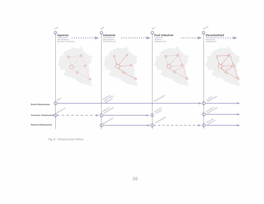
I see the current fragmented state of the infrastructure of Clay County as evolving out of the historical transition of the area, as seen by Fig. 9. You initial-ly have a “Agrarian” network of self-sufficient and largely independent points. People work, people live, people worship all within these same small hollows, these points here. With the arrival of salt and coal you see the “industrial” net-work: one that is highly centralized and specialized, people live in there houses, work in the mines, do business in the towns. It’s an imposed order that has nothing to do with the existing economic, social, or physical infrastructure but as long as you have coal there, its the linchpin that holds everything together.
But what happens when it leaves? What is left is a the post-industrial network: a fragmented order in which these spaces are far removed from each other and those essential community elements are removed from each other, leav-ing people isolated and making spaces alienating. To use the example of Manchester, unless you are going to the courthouse or doing your laundry, why would you come into town? You have a community without its center.
3 types of infrastructure:Physical: Buildings | Roads | AdministrationThis infrastructure was initially constructed by industry and large state project but currently finds itself in stages of disuse as the physical infrastructure ages and isn’t well maintained. Activity brought into the area can re-anchor the physical network.
Economic: Resources | Capital | ProductionRural areas are defined in their high value of natural resources but low produc-
AgrarianIndependent Self Suffi cientDomestic Production
Post IndustrialFracturingIsolationAbandonment
DecentralizedDiversifi cationReciprocitySolidifi cation
IndustrialCentralization SpecializationGrowth/Density
Social Infrastructure
Economic Infrastructure
Physical Infrastructure
Origin
17001865
1970Present
Industrial
(replacement)
Redefi ned
goals | sk
ills |
aspiratio
nsMarginalizatio
n
Subsistence
Economic
Collapse Economic
Diversifi catio
n
Cultural
Reaffi rmatio
n
Fragmentation
Urban Re-
connection
Modernization
Fig. 9: Infrastructure History
26
27
tion capacity or capital resource. The economic history of the area has been the most drastically rewritten in the transition from agrarian to industrial and again when industry moves out. Currently the economic infrastructure is what is failing the most.
Social: Family | Faith | CultureThe strongest infrastructure is the social, which has remained mostly continu-ous throughout the transformation of the area. Manifesting as the strength of community action and personal connection it bears the stressing load as other infrastructures fail and the young and talented leave.
Economy“careful management of available resources” | “sparing or careful use of something”- the critical issue facing small town and rural areas as being especially uncer-tain in the struggle to transition into a “post-industrial” economy
Industrial Economy: bring jobs | strain on infrastructure1) centralized: 2) singular economy:3) resource extraction:4) Large capital investment:
Diverse Economy bring jobs | Reinforces infrastructure1) decentralized: 2) variety economy:3) brings something to Manchester:4) small capital investment:
Manchester is distinguished as being the center of the whole community. It is the face and the heart of the Clay County with a lot of use by a more transit population that come from either far off rural areas within the County, or far off beyond the County. An economic center, an administrative center, and not to forget the population that still lives within the city.
There is a great diversity of activity in Manchester as it is (with houses next to offices next to churches next to stores) but this takes place in a fragmented and isolated manner. The design exercise then is to facilitate interrelations be-tween these activities that allows them to support each other and strengthen their ability for spontaneous independent improvement. In other words, to help these people talk to each other so they can help themselves.
28
Connecting Places/Connecting Spaces
From a regional perspective, the biggest driving issue is that of connectiv-ity. Long distances and fracturing infrastructure threaten to isolate areas from each other without providing them with the needs to support themselves. A regional strategy of strengthening connections between two different scales, the scale of “place” and the scale of “space.”
Connecting Places: Manchester | OneidaPlaces are spaces with more than their physical definition. They have an iden-tity that distinguishes them as recognizable places. The attain a meaning. In this scheme, node-towns are can be called “places” and have a long dis-tance relationships with each other. meaning the connection is not physical but understood.Connection between places is Mental1) the relation of independent identity 2) the coherent continuity of visual coding
Connecting Spaces: Downtown | Civic NodeSpaces are the usual realm of designed architecture. They can be functional and well crafted but what is most important within this project is their continuity with each other. The fragmentation of infrastructure has left the relationships between spaces as ambiguous, uninviting, and alienating. Design then seeks to define that relationship between the designed spaces.
Connection between places is Physical1) the continuous urban sequence 2) the interrelation of activities
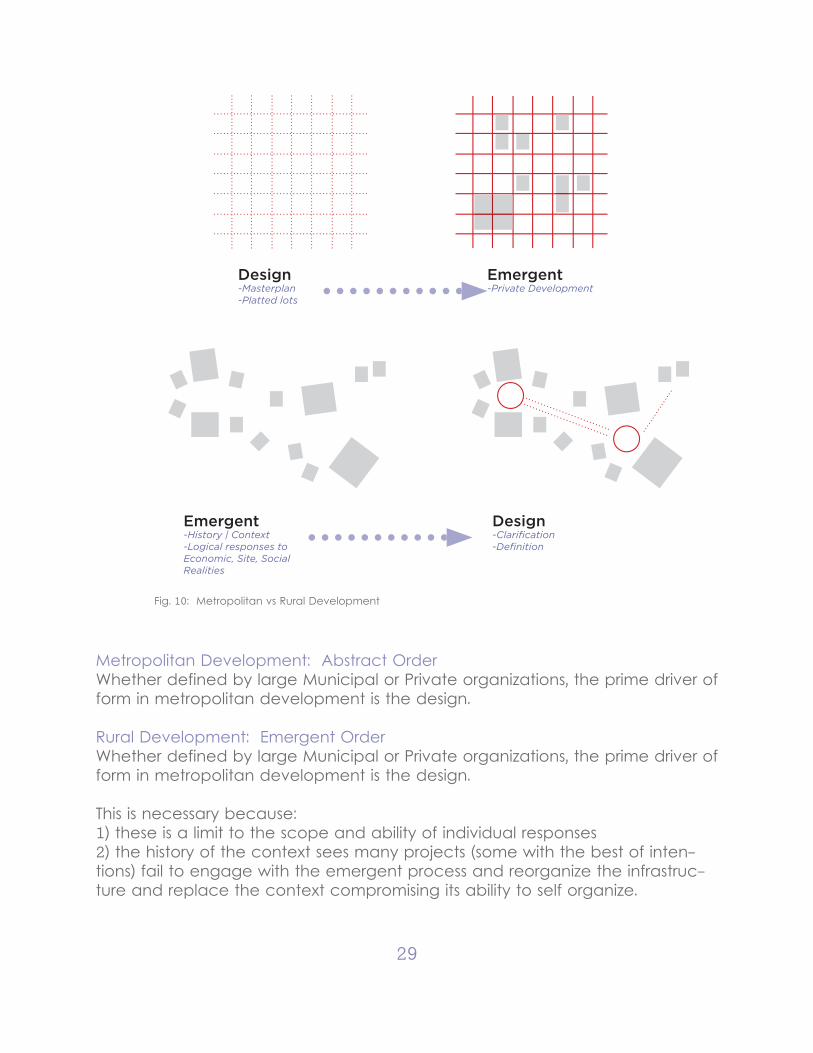
Rural vs Metropolitan
The idea is that what distinguishes small towns from large metropolis is the rela-tionship between the designed and the emergent. Large cities begin with the abstract design, like the laying of a grid, and fill in plots to form the emergent fabric. With small towns the emergent comes first with design following of at all.
Emergent in this context is defined as the aggregate of individual responses to material concerns, other words “people doing what they can with what they have.” Emergent becomes the rule for low density and low resources, which both are the case in Clay County. The design then is to identify the emerg-ing patterns of organization and strengthened those connections to create a responsive infrastructure.
29
Metropolitan Development: Abstract OrderWhether defined by large Municipal or Private organizations, the prime driver of form in metropolitan development is the design.
Rural Development: Emergent OrderWhether defined by large Municipal or Private organizations, the prime driver of form in metropolitan development is the design.
This is necessary because:1) these is a limit to the scope and ability of individual responses2) the history of the context sees many projects (some with the best of inten-tions) fail to engage with the emergent process and reorganize the infrastruc-ture and replace the context compromising its ability to self organize.
Design-Masterplan-Platted lots
Emergent-Private Development
Emergent-History | Context-Logical responses to Economic, Site, SocialRealities
Design-Clarifi cation-Defi nition
Fig. 10: Metropolitan vs Rural Development
30
So in this particular scheme we are trying to engage wit this process with a decentralized model both on the regional and urban scale. This decentralized model is defined by1) nodes: which have a degree of self sufficiency have a distinguishable iden-tity but not a singular use2) connection: a reciprocal relationship between these point together over long distances by the visual encoding physical continuity correlative function-ality.
So this regional decentralized model is going to look different from the new ur-banist transect or garden city model. You don’t have an initially dense urban core that sprawls out into the landscape, you have an initially sprawled out population that is brought together. Mainly a historical process in response to modernization and industry.
So with this particular decentralized regional node model has three levels (cen-tral node, local node, and hollow scale) each with a different function within the network and its own independent identity. They are self sufficient to a de-gree but have a reciprocity.
So looking at the urban scale we are looking at two node typologies, a central and a local because while different and to a degree independent. These two need each other to exist. Manchester (central node) is the administrative/eco-nomic center and public face for the entity of clay county. Oneida (the local node) is the local community center with a direct interface with the individual hollows.
Regional Resource Strategy:
Regional Strategy Node Map:In critically reexamining the design methodology for this particular context, the regional paradigm that this design fits into must also be rethought. The larger regional strategy of Garden Cities and New Urbanist Transect that center on a large metropolitan area are not applicable here; the nearest such city is hours away. This urban thinking imagines growth as moving from a centralized hub to spread out as development.
Such a diagram doesn’t exist here nor addresses the major issues. The popula-tion is already spread out quite far and the rural network is instead something that brings people together not spread them out and supports and indepen-dent rather than collective lifestyle.
31
So, this context section instead develops a contextual regional strategy, a decentralized rural network. This network is spread out, local, and low density and is a main framework to understand the long distant relationships between places. This is both analytical and prescription, positing how these connec-tions currently exist, and how new development within the region can support those connections.
While cities are defined by their compactness and density, rural areas are de-fined by their expansiveness and remoteness. These are not characteristics that to be eliminated but are the essence of the context and why often people choose to live here. The relationship then between different places and dif-ferent people acts over much longer distances with different characteristics, which can be explored.
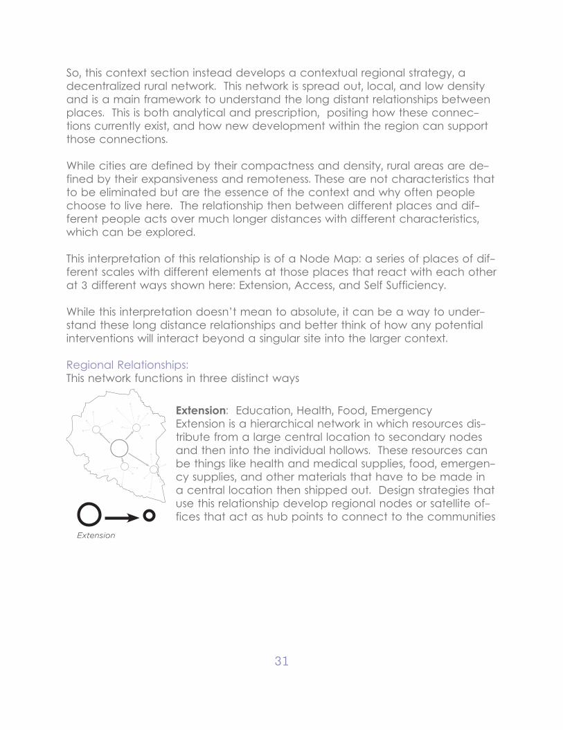
This interpretation of this relationship is of a Node Map: a series of places of dif-ferent scales with different elements at those places that react with each other at 3 different ways shown here: Extension, Access, and Self Sufficiency.
While this interpretation doesn’t mean to absolute, it can be a way to under-stand these long distance relationships and better think of how any potential interventions will interact beyond a singular site into the larger context.
Regional Relationships:This network functions in three distinct ways
Extension
Extension: Education, Health, Food, EmergencyExtension is a hierarchical network in which resources dis-tribute from a large central location to secondary nodes and then into the individual hollows. These resources can be things like health and medical supplies, food, emergen-cy supplies, and other materials that have to be made in a central location then shipped out. Design strategies that use this relationship develop regional nodes or satellite of-fices that act as hub points to connect to the communities
32
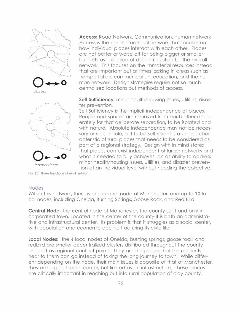
Access
Independence
Access: Road Network, Communication, Human networkAccess is the non-hierarchical network that focuses on how individual places interact with each other. Places are not better or worse off for being bigger or smaller but acts as a degree of decentralization for the overall network. This focuses on the immaterial resources instead that are important but at times lacking in areas such as transportation, communication, education, and the hu-man network. Design strategies require not so much centralized locations but methods of access.
Self Sufficiency: minor health/housing issues, utilities, disas-ter prevention, Self Sufficiency is the implicit independence of places. People and spaces are removed from each other delib-erately for that deliberate separation, to be isolated and with nature. Absolute independence may not be neces-sary or reasonable, but to be self reliant is a unique char-acteristic of rural places that needs to be considered as part of a regional strategy. Design with in mind states that places can exist independent of larger networks and what is needed to fully achieves an as ability to address minor health/housing issues, utilities, and disaster preven-tion at an individual level without needing the collective.
Fig. 11: Three functions of rural network
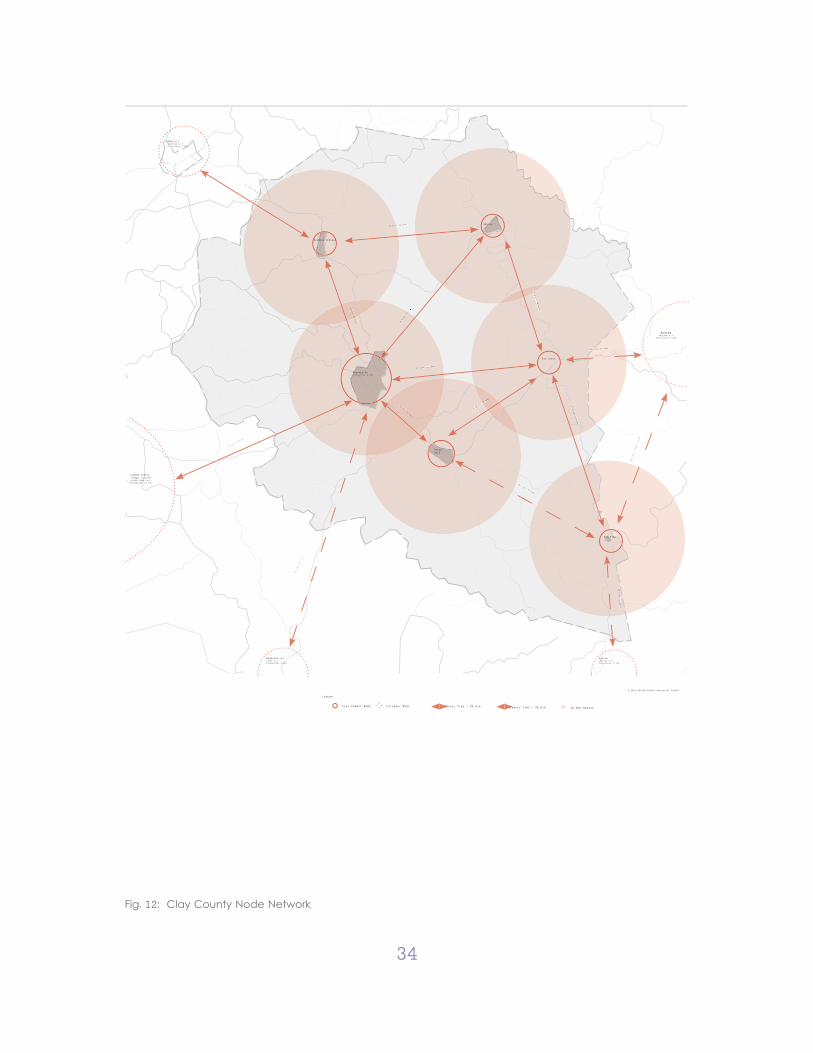
NodesWithin this network, there is one central node of Manchester, and up to 10 lo-cal nodes: including Oneida, Burning Springs, Goose Rock, and Red Bird
Central Node: The central node of Manchester, the county seat and only in-corporated town. Located in the center of the county it is both an administra-tive and infrastructural center. Its problem is that it struggles as a social center, with population and economic decline fracturing its civic life.
Local Nodes: the 4 local nodes of Oneida, burning springs, goose rock, and redbird are smaller decentralized clusters distributed throughout the county and act as regional contact points. They are the places that the residents near to them can go instead of taking the long journey to town. While differ-ent depending on the node, their main issues is opposite of that of Manchester, they are a good social center, but limited as an infrastructure. These places are critically important in reaching out into rural population of clay county.
33
Hollows: The tertiary nodes are where a majority of the population live and are the most remote and independent. Designing them is not the intent but a study of their layout is critical to understand that rural lifestyle that is being sup-ported by the network.
Rural Network: Node MapAs it currently exists, what improvements Clay County has made for itself are isolated projects, removed from their context and removed from each other. The pieces of a great rural community exist within Manchester Kentucky. The design of this thesis then will be to make two pieces fit together. This will require a combination of big and small moves, both large and small scale but all of which are to strengthen what exists, not replace it.. The design goals for this project then are as follows:
Reestablishing Rural Network: Better facilitate connections between small towns themselves and to the rural areas
Reestablishing Manchester City Center: Focus on Manchester as the main node of population both within the city of Manchester and Clay County
Moderate Remoteness: Support the viability of rural living by making sure even the most remote point can still maintain a connection to those necessary re-sources.
This node map contains an overall structural strategy for Clay County with clus-tered population areas (nodes) and the connection between them (arrows). Each node (circle) represents a grouping of people: Manchester as the main central node, Oneida, Burning Springs as secondary nodes, and tertiary hallows distributed throughout. At each node is a description of what’s there (popula-tion and resources) and what needs to be there. The main connections be-tween areas also noted with how they are currently connected, and how they could be improved. This overall strategy is abstract but informs what can be included at the next level of design effort as the individual node is examined and planned.
34
© 2012 United States Geological Survey
Annville (Jackson co.):Population: 1,095
Hazard (Hazard co.):
Population: 4,456
Barbourville (Knox co.):Population: 3,589
Harlan (Harlan co.):Population: 1,745
ManchesterPopulation: 1,431
Red Bird
London/Corbin Urban cluster (Laurel/knox co.):Population: 21,132
Goose Rock
16.8 mi, 21 m
10.2 mi, 113 mins
42.6 mi, 1 hour 3 mins
7.1 mi, 11 min
24.1 mi, 37 mins
12.3 mi, 19 minins ns
20.6
mi, 25
mins
i, 18 mins 13.5 mi
1 mi, 39 mins
. i 29.1.
17.2 mi, 21 mins
25.2 mi, 35 mins
2 mins
8.4 mi, 12
33.4 mi, 56 mins 4 mi,
17.4 mi, 30 mins
17.4 mi, 33
15.4 mi, 25 mins 25
1
Oneida
Burning Springs
Big Creek
Clay County Node
Legend
External Node 10 min RadiusTravel Time < 30 min Travel Time > 30 min
Fig. 12: Clay County Node Network
35
CHAPTER IV SITE: RETHINKING URBAN PLAN
The role of a designer is to identify those missing relationships and to deliver what can become a “vision plan” that can critically respond to the larger is-sues. This thesis looks at two sites (Manchester and Oneida) as two different typologies that nonetheless have a reciprocal relationship to be considered concurrently during any potential design.
Manchester (Central Node)
Manchester as a main central node has only been partially successful. For-mally, the town contains almost all the elements necessary to successful small town node but spatially has been fragmented. The reason to engage with Manchester at an urban scale is not to place another disconnected element but to reconnect the framework in which individual pieces come together as a cohesive space and community. In short, Manchester is a collection of build-ings but struggles as a town.
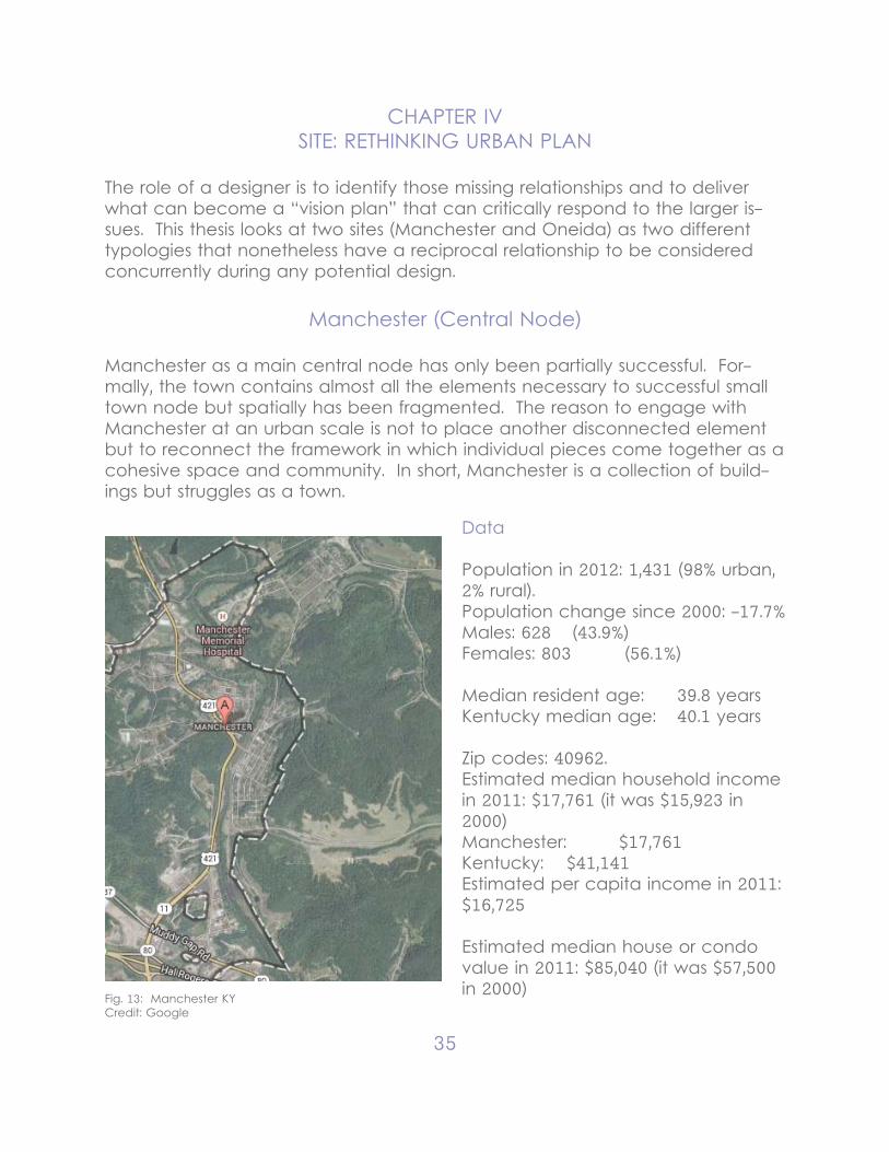
Fig. 13: Manchester KYCredit: Google
Data
Population in 2012: 1,431 (98% urban, 2% rural). Population change since 2000: -17.7%Males: 628 (43.9%)Females: 803 (56.1%)
Median resident age: 39.8 yearsKentucky median age: 40.1 years
Zip codes: 40962.Estimated median household income in 2011: $17,761 (it was $15,923 in 2000)Manchester: $17,761Kentucky: $41,141Estimated per capita income in 2011: $16,725
Estimated median house or condo value in 2011: $85,040 (it was $57,500 in 2000)
36
Manchester: $85,040Kentucky: $120,600
Mean prices in 2011: All housing units: $105,825; Detached houses: $105,654; Townhouses or other attached units: $194,051; In 2-unit structures: $194,051; In 5-or-more-unit structures: $1,234,872; Mobile homes: $48,846Median gross rent in 2011: $382.
Node Study Manchester as a central node gets more explored in more detail. As the central node, many of the important elements as noted by the node plan are intact but are fragmented. This plan then want to reknit together Manches-ter so it can become a cultural center of Clay County. The plan at this scale focuses on two major design issues:
1) Reestablish Manchester City Center.Manchester, at least in principle, is the central node of the Clay County rural network. The city center still retains, in some degrees, much of the active ele-ments that make a active town center: the municipal access of town hall and county seat, an adjacent “square” (now a street), library, church and police station, a main street, and a heritage pavilion in the center. However, these pieces do not talk with each other or create any kind of public space. The area is spatially fragmented, uninviting, and unusable for many civic activities. If the Manchester is to function as a center, it needs a functioning city center for both meeting place of the city and of the county.
The main highway thoroughfare that inhibits most pedestrian activity can be made less intrusive or rerouted to allow usable public space in the city center to see and be seen. Some considerations need for traffic outside of Manches-ter to pass through or stop by, and be given a reason to do so.- Reestablish City Center: Market Street- Main Street- Reroute/Address 421- Bring Activity Downtown
2) Attract New Development: While it is necessary to respond to existing issues, a plan for new development is also necessary for a reestablishing of Manchester downtown in order to bring
37
more activity, spur employment, and give Manchester an identity.
Potential new development needs to: - Responds to Values- Engages the downtown- Knit together the fragmented neighborhoods.- Connections to greater area and give reason for people to visit and move-Manchester a sense of identity and a point of entry into the culture.
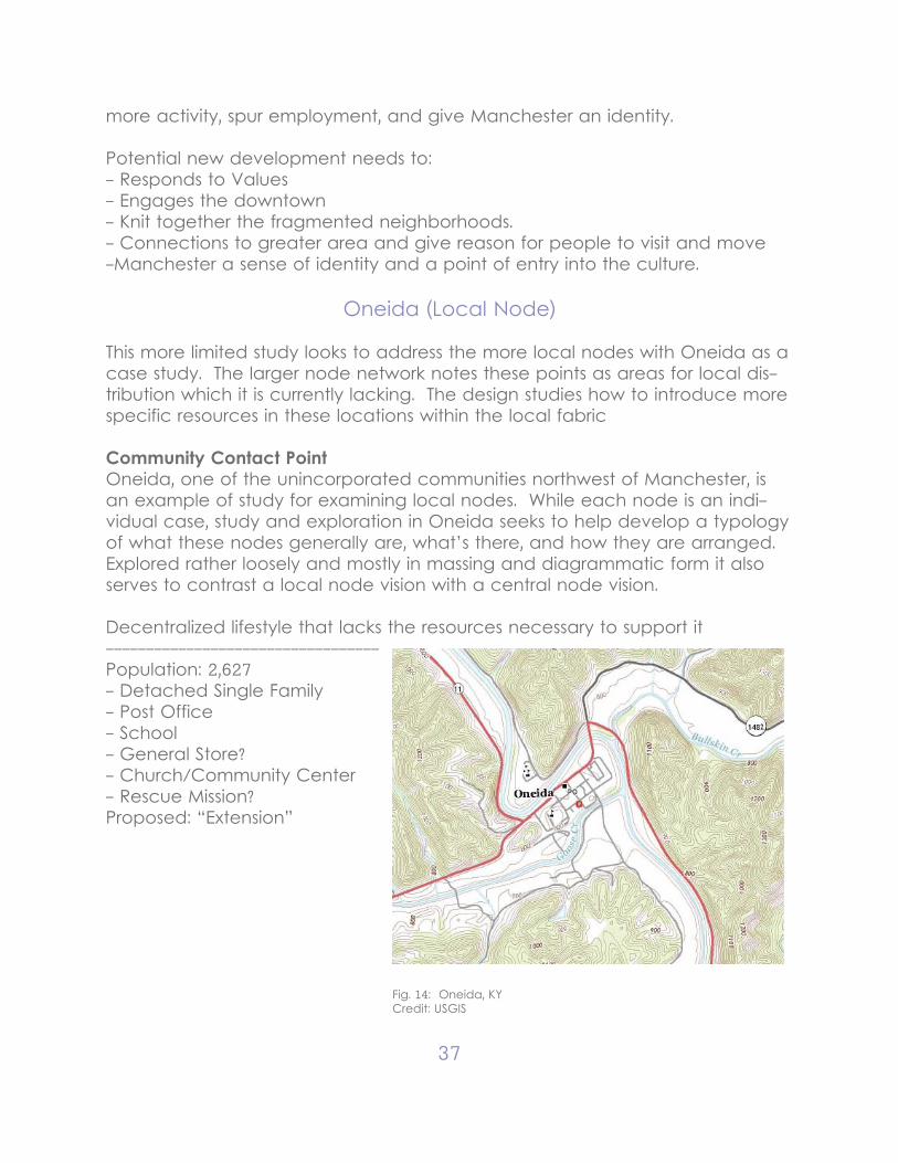
Oneida (Local Node)
This more limited study looks to address the more local nodes with Oneida as a case study. The larger node network notes these points as areas for local dis-tribution which it is currently lacking. The design studies how to introduce more specific resources in these locations within the local fabric
Community Contact PointOneida, one of the unincorporated communities northwest of Manchester, is an example of study for examining local nodes. While each node is an indi-vidual case, study and exploration in Oneida seeks to help develop a typology of what these nodes generally are, what’s there, and how they are arranged. Explored rather loosely and mostly in massing and diagrammatic form it also serves to contrast a local node vision with a central node vision.
Decentralized lifestyle that lacks the resources necessary to support it----------------------------------Population: 2,627- Detached Single Family- Post Office- School- General Store?- Church/Community Center- Rescue Mission? Proposed: “Extension”
Fig. 14: Oneida, KYCredit: USGIS
38
Rethinking Urban Plan
Connecting Places: Manchester | OneidaLooking at a planning level, I am applying that same model of decentralization with nodes and connectivity between them: main nodes, secondary nodes, and the green way system that connects them together.
These nodes are building off of existing “anchors” (schools, courthouse, city hall etc..) but wants to provide a diversity of activity there. There’s something more to do at the civic node than just go to the courthouse.
Manchester- the different paradigms of the cultural value of land (meaning, use, and im-portance) representative of different cultural backgrounds.
Typology: Central Node: Hub of ActivityManchester is distinguished as being the center of the whole community. It is the face and the heart of the Clay County with a lot of use by a more transit population that come from either far off rural areas within the County, or far off beyond the County. An economic center, an administrative center, and not to forget the population that still lives within the city.There is a great diversity of activity in Manchester as it is (with houses next to offices next to churches next to stores) but this takes place in a fragmented and isolated manner. The design exercise then is to facilitate interrelations be-tween these activities that allows them to support each other and strengthen their ability for spontaneous independent improvement. In other words, to help these people talk to each other so they can help themselves. Manchester serves as a point of contact between 3 groups of people each with different needs and interactions with downtown
People1) Local Population: the 1500. (live work play) Most have moved out of down-town to the neighborhoods along the edges and unsurprisingly the economic activity have followed them.
2) Clay County Region: the 20,000. (administration, infrastructure, resources) Manchester is mostly focused on this but at the expense of the unity of down-town. What is the glue that holds these points together?
3) Outside Visitors: countless (tourism, activity, attractiveness, identity) A new group that Manchester has little in the way of addressing but can be a great boost for feeding economic activity. To address them, Manchester needs to be made more accessible and attractive to people that have no experience
39
in the area.
The Success of downtown as a center depends on its function as a hub of ac-tivity for these three groups. To get them I the same place at the same time.
Strengths- existing key anchors- reclaiming urban fabric- connection with nature
Issues- inconsistent visual presence - lack of population- lack of activity
GoalsDowntown Manchester has struggled as an active town center as commer-cial and residential activity moved to the edges of Manchester. To reestablish the downtown as the core of the City and Clay County community. This plan seeks to:
- Explore how new activity can be fit into the city fabric- Reform the public space of streets and squares in a way that is strong public face and supports public activity- Anticipate potential future expansions that grows from downtown and rein-force (not detract) its livelihood- All in a way that supports the historic culture of Manchester.
Actions3 Main Nodes: - Downtown - Civic - EducationSecondary nodes- Recreational- Hospital- Commerce- East ManchesterGreenway Connector
Oneida- the different paradigms of the cultural value of land (meaning, use, and im-portance) representative of different cultural backgrounds.
40
Typology: Local Node: Community OutpostOneida is one of several unincorporated communities have a more local pres-ence. It is a more private in its usage with a population that come from either in Oneida itself or close too. While being limited in scope it still serves as an important contact point and point of extension that can serve people so they don’t have to make the 50 minute trip to Manchester if not needed. Serving more local ability of limited economic needs, emergency preparedness, and primarily social infrastructure, none the less can develop an in identity that can distinguish it from other nodes and attract a more limited visitor presence.More intimate in its scale, the design exercise is to solidify and support its abil-ity as an outpost to reach out to the community and what it needs to support them. Oneida serves as a point of contact between 3 groups of people each with different needs and interactions with downtown
People1) Local Population: the 1200. (live work play) These is the strongest point in Oneida that is mostly still intact.
2) Clay County Region: the 5000?. (administration, infrastructure, resources) This particular function is very limited and has eroded as but can be expanded.
3) Outside Visitors: limited (tourism, activity, attractiveness, identity) There should be a limited presence of visitors but facilitated in a way that respects the more intimate identity.
The Success of Oneida spine as a local node depends on its function as a out-post of activity for these three groups.
Strengths- direct engagement with hollows- existing administrative divisions- existing commerce
Issues- limited ability to serve community - no platform for social identity - visually unapproachable
GoalsMore intimate in its scale, the design exercise is to solidify and support its abil-ity as an outpost to reach out to the community and what it needs to support
41
them.
Actions1 Main Nodes: - Community Contact pointSecondary nodes- Entry sign- Garden node- Artisan nodeGreenway entry sequence
42
Chapter V: ARCHITECTURE: RETHINKING CIVIC SPACE
Architectural Fragments - Urban Trail Markers
From an architectural level, I want to specifically address the connectivity be-tween the points. The biggest issue with the connectivity of the “urban” space is its lack of readability. What is where? Where does it lead? Where is the en-trance, center, edge? The visual definition has been compromised.
We are looking at 3 specific streets, two in Manchester and one in Oneida, that I would see as the main connection between the nodes. To clarify the urban sequence a series of architectural fragments and green spaces are used to frame landmarks and view corridors so that the existing important structures can be placed in relation to each other.
Similar to the Pope Sixtus Plan for Rome in which the amorphous vernacular is mapped by landmarks and axes but different in that:1) Contextual - building off of existing corridors and landmarks2) Smaller in scale3) Composed but not in strictly formal terms - Discontinuous so that each break in the sequence (a node) is a location
Instead of utilizing a single Building/Object to solidify urban space (which has been used extensively before) the architectural response is actually fragment-ed between different spaces that are unified as one travels through the entire urban sequence. Individually they are artifacts but together the mark a sequence through an urban space
To Clarify the urban sequence a series of architectural fragments and green spaces are used to frame landmarks and view corridors so that the existing im-portant structures can be placed in relation to each other.
Fragmented Streetscapes:
In the project, a study of three streets, 421 and Main Street in Manchester and River Street in Oneida, are explorations of how a typically urban architectural method, the design of a streetscape, can be achieved in a low density and low resource area. Those constrictions make strictly uniformity and dramatic renovations very ineffective and unmaintainable. So instead, to achieve the same “order,” the cohesiveness of the street is to be understood as a series of
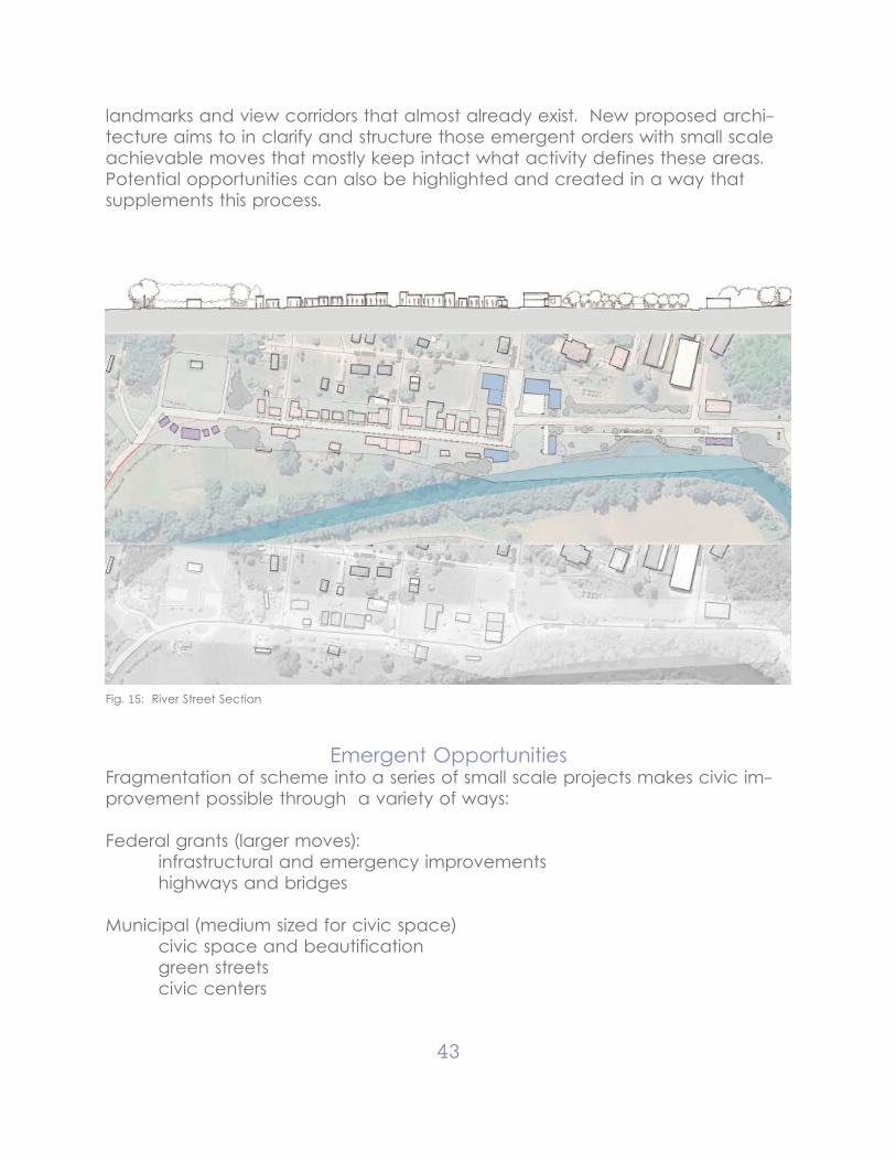
43
landmarks and view corridors that almost already exist. New proposed archi-tecture aims to in clarify and structure those emergent orders with small scale achievable moves that mostly keep intact what activity defines these areas. Potential opportunities can also be highlighted and created in a way that supplements this process.
Fig. 15: River Street Section
Emergent OpportunitiesFragmentation of scheme into a series of small scale projects makes civic im-provement possible through a variety of ways:
Federal grants (larger moves): infrastructural and emergency improvements highways and bridges
Municipal (medium sized for civic space) civic space and beautification green streets civic centers
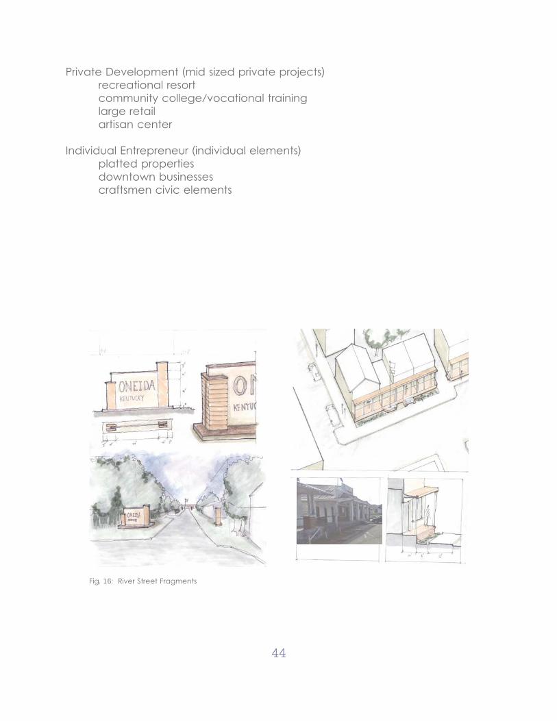
44
Private Development (mid sized private projects) recreational resort community college/vocational training large retail artisan center
Individual Entrepreneur (individual elements) platted properties downtown businesses craftsmen civic elements
Fig. 16: River Street Fragments
45
Chapter VI: CONCLUSIONS AND RECOMMENDATIONS
The design project is not intended as to be specific recommendations for the development of Clay County as much as a study of effective goals and meth-ods. What design recommendations made through the fragmented archi-tectural components are meant to be an example of how small individual projects from a variety of scales and develop a greater structure without the strictly enforced conformity often required by urban designs. Above all, these become the Emergent Opportunities of carefully placed catalyst specifically designed and placed to affect large change.
Evaluating Success
Manchester Downtown Revitalization1) Return residential2) Return commercial activity3) Density and diversity of activity within 5 minute walk4) Enhanced walkability5) New anchors adjacent to existing anchors : community center, EKY Down-town, Civic Plaza6) Enhanced civic presence7) greenway connector to exterior nodes
Oneida Solidify village center and spine1) New shops2) Artisan center 3) Enhanced visual presence4) Better Outreach to Community
Clay County Enhancing connectivity1) Address Hollow isolation2) Respect important contextual elements / relationships3) Formalization of “community center”4) Extension to remote hollows5) Better presentation to attract new residents and retain existing
46
Opportunities Highlighted
-Existing civic centers have been active existing anchors but do little to en-gage adjacent under-utilized space
-Clay County already identifies local centers that have potential as community nodes (like Oneida)
-Beautification of civic space can be achieved through modest projects and reinforcing the quirky irregular vernacular and connecting back to nature
-Public space and streets are unattractive and have limited function:In addressing streets it is easy to: -maximize walkability -more effective address parking -develop opportune sites for private development
-Modest projects reinforce each other and allow larger scale action
-Parking is often addressed as distinct lots that destroy building and occupy lots but can be addressed in the design of enhanced public space. e.g. mov-ing parking to rear to maximize walkable space.
Lessons Learned
Urban methodology can be transformed to become useful and appropriate agents in addressing small town when allowed to engage with the informal vernacular.
- Analyze context -> Identify Emergent Patterns -> Reinforce Processes
- Nodes reinforced existing points of activity without replacing them.
- Use of streetscape “axis” can be achieved informally and contextually
- Biggest issues: visual incoherence vacancy of place preference for car over pedestrian location isolation
- Most meaningful changes are those that engage not replace
- Decentralization allows locality and diversity
47
ConclusionIn exploring the applications of the methodologies of Urban Design in rural areas I think I can conclude that there is in fact a meaningful purpose to such actions and methods that can effectively address those purposes. Doing so requires a fundamental redressing of the paradigms that inform urban design theory and practice that reflect the values of the often metropolitan culture of the designers for a paradigm that reflects the values of the rural culture. These values such as concreteness, contextually, intimacy and informality when criti-cally applied to the design process can challenge the expectations for form in such cases. Urban methods like master planning and streetscape develop-ment can be still retained for their great abilities to develop opportunities and establish order. However, it is important to make sure that those “opportunities” are appropriate to the context and respond to existing concerns and that “or-der” responds to the emergent order that defines rural livelihood.

48
LIST OF REFERENCES
49
Bigger, Jeff. The United States of Appalachia. Shoemaker & Hoard, 2005.
Carr, Patrick and Maria Kefalas. Hollowing Out the Middle: Rural Brain Drain and What it Means for America. Boston: Beacon Press, 2009
Haring, Joseph. Urban and Regional Economics: Perspectives for Public Action. Houghton Mifflin Company, 1972.
Loomis, Mildred. Decentralism: Where it came from-Where is it going? Montreal/New York/London: Black Rose Books, 2005.
Craycroft, Robert and Michael Fazio, ed. Change and Tradition in the Ameri-can Small Town. Jackson: University Press of Mississippi, 1983.
Stern, Robert. New Directions in American Architecture. NewYork: George Bra-ziller, 1969.
Swentzell, Rina “Conflicting Landscape Value: The Santa Clara Pueblo and Day School” Understanding Ordinary Landscapes. New Haven and London: Yale University Press, 1997
Rojas, James. “The Enacted Environment.” Everyday America: Cultural Land-scape Studies. Berkeley: University of California Press, 2003
Daniels, Thomas, John Keller and Mark Lapping. The Small Town Planning Handbook. Washington, DC: American Planning Association.
Stein, Clarence. Towards New Towns for America. Cambridge: The MIT Press.
Unwin, Raymond. Town Planning in Practice. New York, 1971.
Seabrook, John. Nobrow:: The Culture of Marketing and the Marketing of Cul-ture Alfred Knopf, New York: 2000
DePillis, Lydia. “If You Rebuild It, They Might Not Come: Brad Pitt’s beautiful houses are a drag on New Orleans” New Republic. Mar. 13 2013

50
VITA
Phillip Geiman is a West Virginia native who graduated with Honors from the University of Maryland with a Bachelors of Science in Architecture. A small town upbringing and big city education taught him well the importance of place, both rural and urban, in how design and construction impacts the historical context and the daily livelihoods of the people living within them.
In graduate school, Phillip continued his education in those most critical con-centrations for an architect, those of Urban Design and Historical Concentra-tion and Stewardship so to best understand how to put the right building in the right place in a way that respects the nature of the place. Above all, he wish-es to work in a way that requires critical thinking, flexibility, and active engage-ment in a cooperative profession.