Embed Size (px)
Citation preview
04-Sep-2015 Prepared for – Department of Health and Human Services – ABN: 74 410 330 756
Emergency Medical Services
Hospital Heliport Flight Path Protection
Context Scan for Stage 1 Hospitals
AECOM
Emergency Medical Services - Hospital Heliport Flight Path Protection
D R A F T
04-Sep-2015 Prepared for – Department of Health and Human Services – ABN: 74 410 330 756
Emergency Medical Services - Hospital Heliport Flight Path
Protection
Context Scan for Stage 1 Hospitals
Client: Department of Health and Human Services
ABN: 74 410 330 756
Prepared by
AECOM Australia Pty Ltd
Level 9, 8 Exhibition Street, Melbourne VIC 3000, Australia
T +61 3 9653 1234 F +61 3 9654 7117 www.aecom.com
ABN 20 093 846 925
In association with
Kneebush Planning, Rehbein Airport Consulting
04-Sep-2015
Job No.: 60344448
AECOM in Australia and New Zealand is certified to the latest version of ISO9001, ISO14001, AS/NZS4801 and OHSAS18001.
© AECOM Australia Pty Ltd (AECOM). All rights reserved.
AECOM has prepared this document for the sole use of the Client and for a specific purpose, each as expressly stated in the document. No other
party should rely on this document without the prior written consent of AECOM. AECOM undertakes no duty, nor accepts any responsibility, to any
third party who may rely upon or use this document. This document has been prepared based on the Client’s description of its requirements and
AECOM’s experience, having regard to assumptions that AECOM can reasonably be expected to make in accordance with sound professional
principles. AECOM may also have relied upon information provided by the Client and other third parties to prepare this document, some of which
may not have been verified. Subject to the above conditions, this document may be transmitted, reproduced or disseminated only in its entirety.
AECOM
Emergency Medical Services - Hospital Heliport Flight Path Protection
D R A F T
04-Sep-2015 Prepared for – Department of Health and Human Services – ABN: 74 410 330 756
Quality Information
Document Emergency Medical Services - Hospital Heliport Flight Path Protection
Ref
60344448
p:\603x\60344448\8. issued docs\8.1 reports\stage 1 20150914\appendix a - stage
1 heliports 20150901.docx
Date 04-Sep-2015
Prepared by Ben Mahon
Reviewed by Trent Kneebush (Kneebush Planning) and Greg Harrison (AECOM)
Revision History
Revision Revision
Date Details
Authorised
Name/Position Signature
1 18-May-
2015
Draft Report Greg Harrison
Technical Director
Original Signed
AECOM
Emergency Medical Services - Hospital Heliport Flight Path Protection
D R A F T
04-Sep-2015 Prepared for – Department of Health and Human Services – ABN: 74 410 330 756
Table of Contents
1.0 Introduction 2 2.0 Alfred Hospital 3
2.1 HLS Site Summary 3 2.2 Land Use Planning Context Information 4
3.0 Frankston Hospital 9 3.1 HLS Site Summary 9 3.2 Land Use Planning Context Information 10
4.0 Monash Medical Centre Clayton 13 4.1 HLS Site Summary 13 4.2 Land Use Planning Context Information 14
5.0 Royal Childrens Hospital 17 5.1 HLS Site Summary 17 5.2 Land Use Planning Context Information 18
6.0 Royal Melbourne Hospital 22 6.1 HLS Site Summary 22 6.2 Land Use Planning Context Information 23
7.0 Warragul Hospital 27 7.1 HLS Site Summary 27 7.2 Land Use Planning Context Information 28
Photo 1: Alfred Hospital, view to the west 3 Photo 2: Frankston Hospital, view to the east 9 Photo 3: Monash Medical Centre Clayton, view of Children’s Hospital under construction 13 Photo 4: Royal Childrens Hospital, view to the south-east 17 Photo 5: Royal Melbourne Hospital, view to the south-west 22 Photo 6: Royal Melbourne Hospital, view to the south-west 27
Figure 1: Planning Scheme Zone Map at Alfred Hospital 7 Figure 2: Planning Scheme Overlay Map at Alfred Hospital 8 Figure 3: Planning Scheme Zone Map at Frankton Hospital 11 Figure 4: Planning Scheme Overlay Map at Frankton Hospital 12 Figure 5: Planning Scheme Zone Map at Monash Hospital 15 Figure 6: Planning Scheme Overlay Map at Monash Hospital 16 Figure 7: Planning Scheme Zone Map at Royal Childrens Hospital 19 Figure 8: Planning Scheme Overlay Map at Royal Childrens Hospital 20 Figure 9: Planning Scheme Zone Map at Royal Melbourne Hospital 25 Figure 10: Planning Scheme Overlay Map at Royal Melbourne Hospital 26 Figure 11: Planning Scheme Zone Map at Warragul Hospital 29 Figure 12: Planning Scheme Overlay Map at Warragul Hospital 30
Table 1: DDOs intersecting heliport flight paths at Alfred Hospital 6 Table 2: Zones intersecting heliport flight paths that may have scheduled heights at Alfred Hospital 6 Table 3: DDOs intersecting heliport flight paths at Royal Childrens Hospital 21 Table 4: Zones intersecting heliport flight paths that may have scheduled heights at Royal Childrens Hospital 21 Table 5: DDOs intersecting heliport flight paths at Royal Melbourne Hospital 24 Table 6: Zones intersecting heliport flight paths that may have scheduled heights at Royal Melbourne Hospital 24
AECOM
Emergency Medical Services - Hospital Heliport Flight Path Protection
D R A F T
04-Sep-2015 Prepared for – Department of Health and Human Services – ABN: 74 410 330 756
2
1.0 Introduction
The Department of Health and Human Services (DHHS) has engaged AECOM, Rehbein Airport Consulting and
Kneebush Planning to undertake the Emergency Medical Services - Hospital Heliport Flight Path Protection
project.
The purpose of the project is to protect the flight paths of Helicopter Landing Sites (HLS) at 19 public hospitals in
Victoria and one in Albury New South Wales. The overarching objective of the project is to protect the flight paths
of HLS on public hospital grounds from intrusion by obstacles due to inappropriate development. In other words,
the project is about operationally safeguarding the airspace corridor for helicopter Emergency Medical Services,
which are an essential community service.
In the absence of a tailored planning control to protect or safeguard the flight paths of hospital based helipads, the
capacity for Air Ambulance Victoria, the affected hospital and the DHHS, to minimise the impacts of third party
development on helicopter flight paths is significantly diminished.
The proposed Planning Scheme Amendment will introduce into the applicable planning schemes for the Stage 1
Hospitals (refer to Section 3 of the Summary Report) new Design and Development Overlays (DDOs) and a
referral requirement to the DHHS.
The purpose of this Context Scan is to:
- Provide a brief description of the existing conditions at the Stage 1 Hospital heliports and their surrounds
- Identify relevant Council strategies, planning scheme amendments, planning policies and planning controls
that relate to the land affected by the proposed Amendment.
The Stage 1 Hospital heliports are:
- Alfred Hospital
- Royal Childrens Hospital
- Royal Melbourne Hospital
- Frankston Hospital
- Warragul Hospital.
AECOM
Emergency Medical Services - Hospital Heliport Flight Path Protection
D R A F T
04-Sep-2015 Prepared for – Department of Health and Human Services – ABN: 74 410 330 756
3
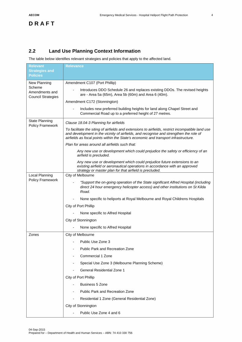
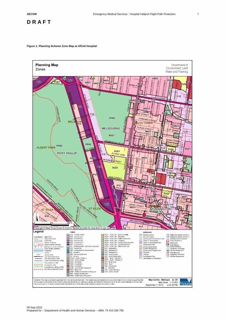
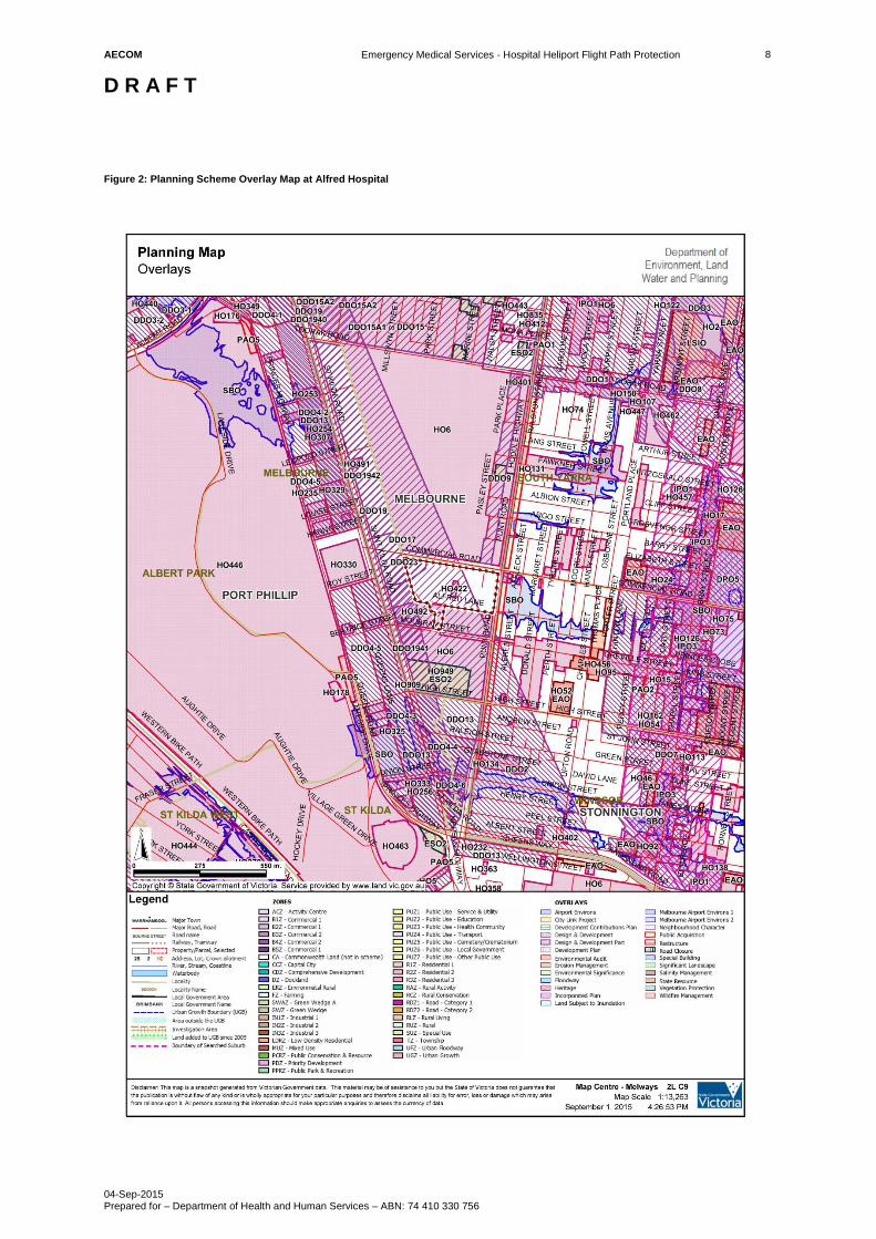
2.0 Alfred Hospital
The Alfred Hospital is located at 55 Commercial Road, Melbourne. The hospital helipad is in the City of
Melbourne, but the flight paths are also within the Cities of Port Phillip and Stonnington. The relevant planning
schemes are therefore and the Melbourne Planning Scheme, Port Phillip Planning Scheme and Stonnington
Planning Scheme. The Emergency Medical Services (EMS) helipad is 15.7m AHD and is positioned on a purpose
built elevated structure above Commercial Road. There are three EMS helicopter flight paths to/from the helipad
(refer to Appendix B in the Technical Heliport Flight Path Report for The Alfred Hospital). Figure 1 and Figure 2
identify the existing zones and overlays in proximity to the EMS helipad and helicopter flight paths.
The first EMS helicopter flight path is to the north. It is within the City of Melbourne and it tracks over parkland
(Fawkner Park). The second is to the west. It is within the City of Melbourne and Port Philip and it tracks over an
arterial road (Commercial Road), predominately mid-high rise residential and commercial buildings, and parkland
(Albert Park Lake). The third is to the east. It is within the City of Melbourne and Stonnington and it tracks over an
arterial road (Commercial Road), parkland (Fawkner Park) and predominately low-mid-rise residential and
commercial buildings.
Given the prevailing urban development and built form, the height of the helipad (15.7m AHD), trajectory of the
helicopter and the distance to affected land it is likely that the majority of land would be unaffected by the
proposed DDOs. However, there are planning controls (see Table 1 and Table 2) applied to land fronting St Kilda
Road (City of Melbourne and Port Phillip), Commercial Road and Punt Road (City of Melbourne and Stonnington)
that encourage heights greater than the proposed DDOs. Where new developments and associated works (e.g.
cranes) would penetrate the proposed DDOs then these would need to be the subject of a planning permit
application and referred to the DHHS for assessment.
2.1 HLS Site Summary
Hospital Alfred Hospital
Address 55 Commercial Road , Melbourne, VIC, 3004
Operator Alfred Hospital
Municipality Melbourne, Stonnington and Port Phillip
Planning Authority Cities of Melbourne, Stonnington and Port Phillip
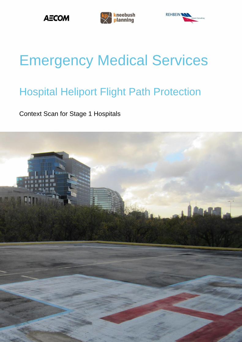
Photo 1: Alfred Hospital, view to the west
AECOM
Emergency Medical Services - Hospital Heliport Flight Path Protection
D R A F T
04-Sep-2015 Prepared for – Department of Health and Human Services – ABN: 74 410 330 756
4
2.2 Land Use Planning Context Information
The table below identifies relevant strategies and policies that apply to the affected land.
Relevant
Strategies and
Policies
Relevance
New Planning
Scheme
Amendments and
Council Strategies
Amendment C107 (Port Phillip)
- Introduces DDO Schedule 26 and replaces existing DDOs. The revised heights
are - Area 5a (65m), Area 5b (60m) and Area 6 (40m).
Amendment C172 (Stonnington)
- Includes new preferred building heights for land along Chapel Street and
Commercial Road up to a preferred height of 27 metres.
State Planning
Policy Framework Clause 18.04-3 Planning for airfields
To facilitate the siting of airfields and extensions to airfields, restrict incompatible land use and development in the vicinity of airfields, and recognise and strengthen the role of airfields as focal points within the State's economic and transport infrastructure.
Plan for areas around all airfields such that:
Any new use or development which could prejudice the safety or efficiency of an airfield is precluded.
Any new use or development which could prejudice future extensions to an existing airfield or aeronautical operations in accordance with an approved strategy or master plan for that airfield is precluded.
Local Planning
Policy Framework
City of Melbourne
- “Support the on-going operation of the State significant Alfred Hospital (including
direct 24 hour emergency helicopter access) and other institutions on St Kilda
Road.
- None specific to heliports at Royal Melbourne and Royal Childrens Hospitals
City of Port Phillip
- None specific to Alfred Hospital
City of Stonnington
- None specific to Alfred Hospital
Zones City of Melbourne
- Public Use Zone 3
- Public Park and Recreation Zone
- Commercial 1 Zone
- Special Use Zone 3 (Melbourne Planning Scheme)
- General Residential Zone 1
City of Port Phillip
- Business 5 Zone
- Public Park and Recreation Zone
- Residential 1 Zone (General Residential Zone)
City of Stonnington
- Public Use Zone 4 and 6
AECOM
Emergency Medical Services - Hospital Heliport Flight Path Protection
D R A F T
04-Sep-2015 Prepared for – Department of Health and Human Services – ABN: 74 410 330 756
5
Relevant
Strategies and
Policies
Relevance
- Residential Growth Zone 1
- General Residential Zone 12
- Neighbourhood Residential Zone 3
- Commercial 1 Zone
All of the above:
- Road Zone 1
Overlays City of Melbourne
- Heritage Overlays (HO422, H06)
- Design and Development Overlays (DDO17, DDO19-42, DDO23)
City of Port Phillip
- Heritage Overlays (HO330, HO331, H446)
- Design and Development Overlays (DDO4-2, DDO4-3, DDO4-5, DDO13)
City of Stonnington
- Public Acquisition Overlay 1
- Special building Overlay
- Heritage Overlay (HO448, H303, H25, H151, H144)
Other planning
controls
Melbourne, Port Phillip and Stonnington
- Clause 52.15 Heliport and Helicopter Landing Site
No permit is required to use land for a helicopter landing site if any of the following
apply:
o Emergency services: The helicopter landing site is used by a helicopter
engaged in the provision of emergency service operations.
City of Melbourne
- Clause 81 Incorporated Document
o The Alfred Hospital Helipad Flight Path Protection Areas Plan, Vertical
View, reference No. AOS/00/015, dated 7-9-2001 and The Alfred
Hospital Helipad Flight Path Protection Areas Plan, Profile View,
reference No. AOS/00/016, dated 7-9-2001
AECOM
Emergency Medical Services - Hospital Heliport Flight Path Protection
D R A F T
04-Sep-2015 Prepared for – Department of Health and Human Services – ABN: 74 410 330 756
6
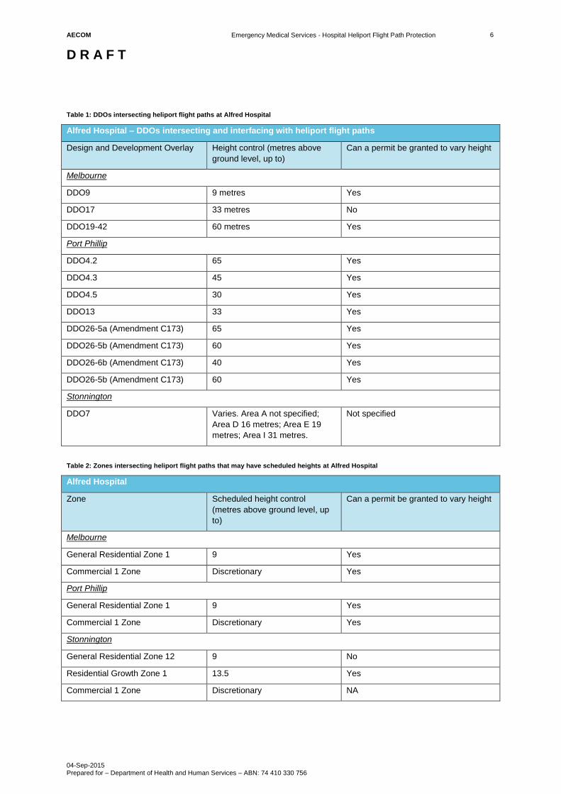
Table 1: DDOs intersecting heliport flight paths at Alfred Hospital
Alfred Hospital – DDOs intersecting and interfacing with heliport flight paths
Design and Development Overlay Height control (metres above
ground level, up to)
Can a permit be granted to vary height
Melbourne
DDO9 9 metres Yes
DDO17 33 metres No
DDO19-42 60 metres Yes
Port Phillip
DDO4.2 65 Yes
DDO4.3 45 Yes
DDO4.5 30 Yes
DDO13 33 Yes
DDO26-5a (Amendment C173) 65 Yes
DDO26-5b (Amendment C173) 60 Yes
DDO26-6b (Amendment C173) 40 Yes
DDO26-5b (Amendment C173) 60 Yes
Stonnington
DDO7 Varies. Area A not specified;
Area D 16 metres; Area E 19
metres; Area I 31 metres.
Not specified
Table 2: Zones intersecting heliport flight paths that may have scheduled heights at Alfred Hospital
Alfred Hospital
Zone Scheduled height control
(metres above ground level, up
to)
Can a permit be granted to vary height
Melbourne
General Residential Zone 1 9 Yes
Commercial 1 Zone Discretionary Yes
Port Phillip
General Residential Zone 1 9 Yes
Commercial 1 Zone Discretionary Yes
Stonnington
General Residential Zone 12 9 No
Residential Growth Zone 1 13.5 Yes
Commercial 1 Zone Discretionary NA
AECOM
Emergency Medical Services - Hospital Heliport Flight Path Protection
D R A F T
04-Sep-2015 Prepared for – Department of Health and Human Services – ABN: 74 410 330 756
7
Figure 1: Planning Scheme Zone Map at Alfred Hospital
AECOM
Emergency Medical Services - Hospital Heliport Flight Path Protection
D R A F T
04-Sep-2015 Prepared for – Department of Health and Human Services – ABN: 74 410 330 756
8
Figure 2: Planning Scheme Overlay Map at Alfred Hospital
AECOM
Emergency Medical Services - Hospital Heliport Flight Path Protection
D R A F T
04-Sep-2015 Prepared for – Department of Health and Human Services – ABN: 74 410 330 756
9
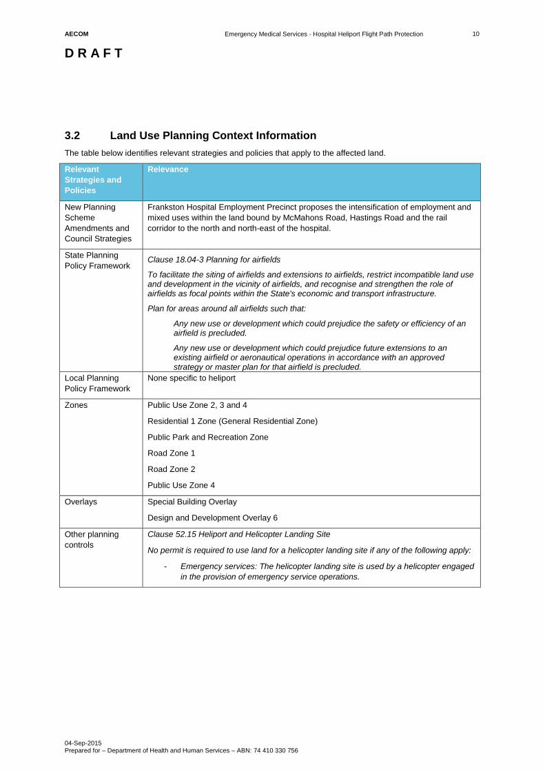
3.0 Frankston Hospital
The Frankston Hospital is located at 2 Hastings Rd, Frankston. The hospital helipad and the flight paths are in the
City of Frankston and subject to the Frankston Planning Scheme. The Emergency Medical Services (EMS)
helipad is 41.1m AHD and is positioned on top of a purpose built structure above a multi-deck car park. There are
three EMS helicopter flight paths to/from the helipad (refer to Appendix B in the Technical Heliport Flight Path
Report for The Frankston Hospital). Figure 3 and Figure 4 identify the existing zones and overlays in proximity to
the EMS helipad and helicopter flight paths.
The first EMS helicopter flight path is to the north and it tracks over the hospital, an area earmarked for
intensification as a mixed use and employment precinct where higher built forms are likely to be encouraged and
existing residential areas where changes to the built form are unlikely to significantly change. The second is to the
west and it tracks over the hospital, parkland and existing residential areas where changes to the built form are
unlikely to significantly change. The third is to the east and it tracks over the hospital, parkland, an area
earmarked for intensification as a mixed use and employment precinct where higher built forms are likely to be
encouraged, Monash University and existing residential areas where changes to the built form are unlikely to
significantly change.
Given the prevailing urban development and built form, the height of the helipad (41.1m AHD), trajectory of
helicopters and the distance to affected land it is likely that the majority of land would be unaffected by the
proposed DDOs. However, the City of Frankston and the Metropolitan Planning Authority are preparing a strategy
and supporting planning controls that would encourage higher buildings within land bounded by McMahons Road,
Hastings Road and the rail corridor. Where new developments and associated works (e.g. cranes) would
penetrate the proposed DDOs then these would need to be the subject of a planning permit application and
referred to the DHHS for assessment.
3.1 HLS Site Summary
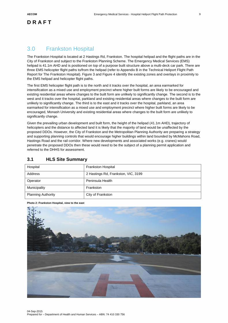
Hospital Frankston Hospital
Address 2 Hastings Rd, Frankston, VIC, 3199
Operator Peninsula Health
Municipality Frankston
Planning Authority City of Frankston
Photo 2: Frankston Hospital, view to the east
AECOM
Emergency Medical Services - Hospital Heliport Flight Path Protection
D R A F T
04-Sep-2015 Prepared for – Department of Health and Human Services – ABN: 74 410 330 756
10
3.2 Land Use Planning Context Information
The table below identifies relevant strategies and policies that apply to the affected land.
Relevant
Strategies and
Policies
Relevance
New Planning
Scheme
Amendments and
Council Strategies
Frankston Hospital Employment Precinct proposes the intensification of employment and
mixed uses within the land bound by McMahons Road, Hastings Road and the rail
corridor to the north and north-east of the hospital.
State Planning
Policy Framework Clause 18.04-3 Planning for airfields
To facilitate the siting of airfields and extensions to airfields, restrict incompatible land use and development in the vicinity of airfields, and recognise and strengthen the role of airfields as focal points within the State's economic and transport infrastructure.
Plan for areas around all airfields such that:
Any new use or development which could prejudice the safety or efficiency of an airfield is precluded.
Any new use or development which could prejudice future extensions to an existing airfield or aeronautical operations in accordance with an approved strategy or master plan for that airfield is precluded.
Local Planning
Policy Framework
None specific to heliport
Zones Public Use Zone 2, 3 and 4
Residential 1 Zone (General Residential Zone)
Public Park and Recreation Zone
Road Zone 1
Road Zone 2
Public Use Zone 4
Overlays Special Building Overlay
Design and Development Overlay 6
Other planning
controls
Clause 52.15 Heliport and Helicopter Landing Site
No permit is required to use land for a helicopter landing site if any of the following apply:
- Emergency services: The helicopter landing site is used by a helicopter engaged
in the provision of emergency service operations.
AECOM
Emergency Medical Services - Hospital Heliport Flight Path Protection
D R A F T
04-Sep-2015 Prepared for – Department of Health and Human Services – ABN: 74 410 330 756
11
Figure 3: Planning Scheme Zone Map at Frankton Hospital
AECOM
Emergency Medical Services - Hospital Heliport Flight Path Protection
D R A F T
04-Sep-2015 Prepared for – Department of Health and Human Services – ABN: 74 410 330 756
12
Figure 4: Planning Scheme Overlay Map at Frankton Hospital
AECOM
Emergency Medical Services - Hospital Heliport Flight Path Protection
D R A F T
04-Sep-2015 Prepared for – Department of Health and Human Services – ABN: 74 410 330 756
13
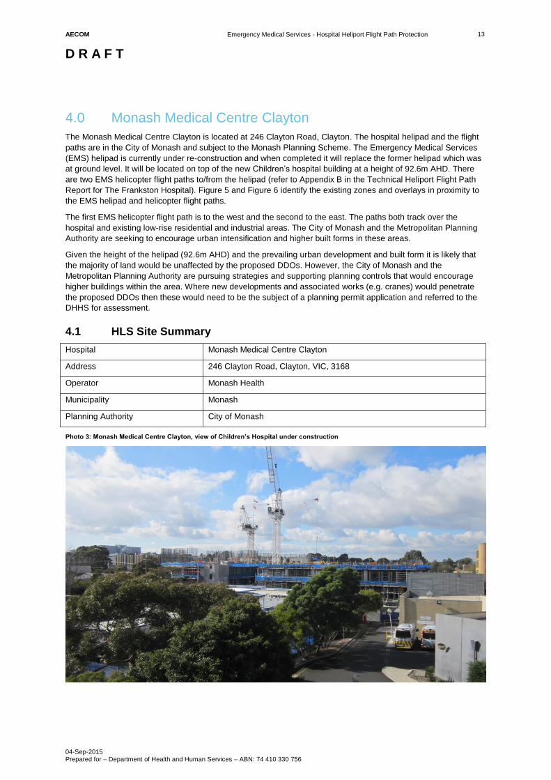
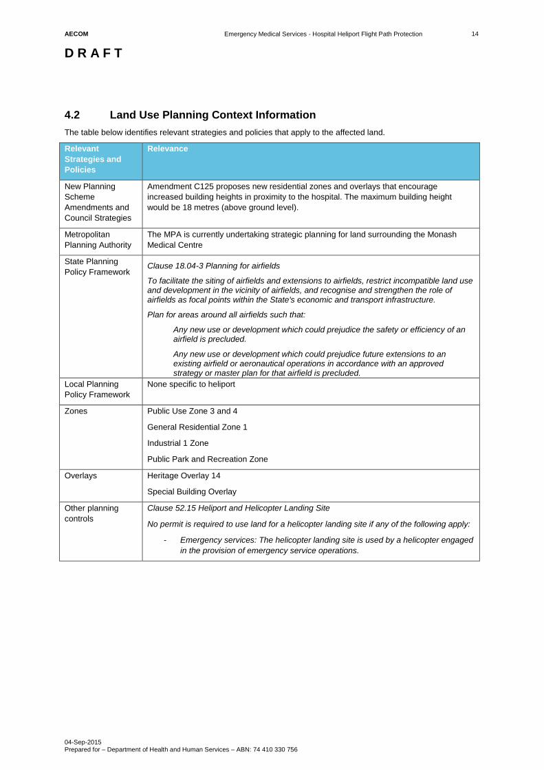
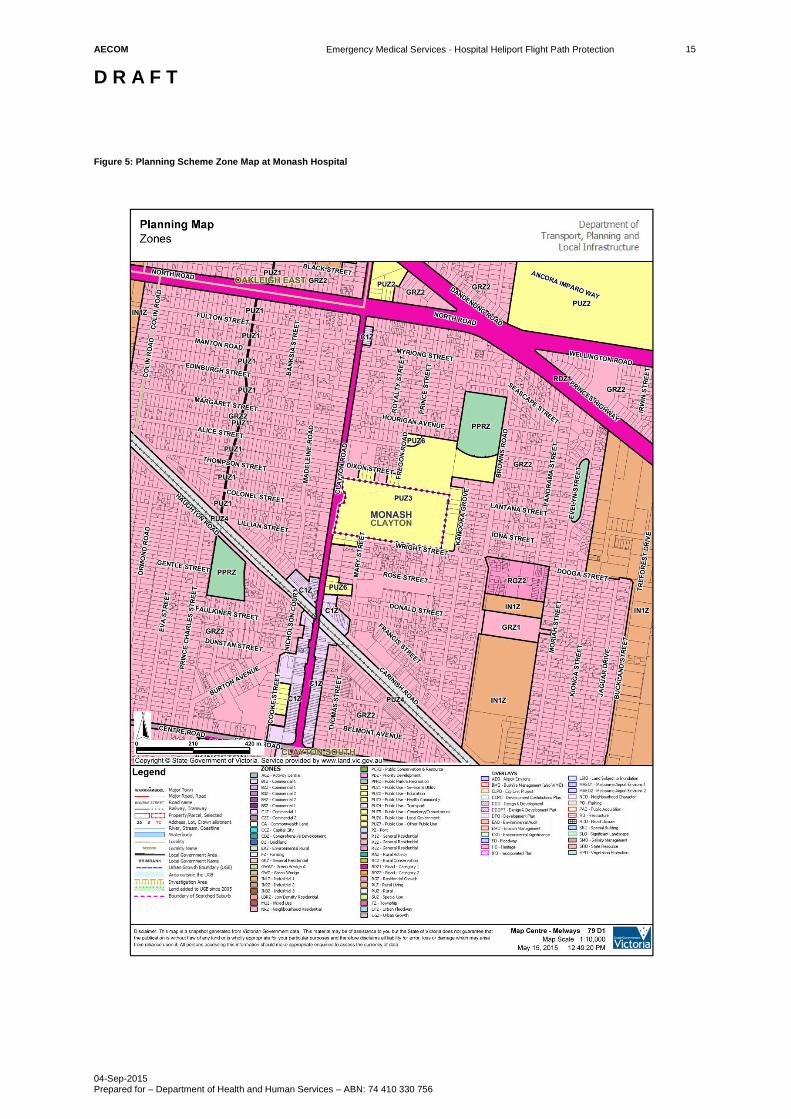
4.0 Monash Medical Centre Clayton
The Monash Medical Centre Clayton is located at 246 Clayton Road, Clayton. The hospital helipad and the flight
paths are in the City of Monash and subject to the Monash Planning Scheme. The Emergency Medical Services
(EMS) helipad is currently under re-construction and when completed it will replace the former helipad which was
at ground level. It will be located on top of the new Children’s hospital building at a height of 92.6m AHD. There
are two EMS helicopter flight paths to/from the helipad (refer to Appendix B in the Technical Heliport Flight Path
Report for The Frankston Hospital). Figure 5 and Figure 6 identify the existing zones and overlays in proximity to
the EMS helipad and helicopter flight paths.
The first EMS helicopter flight path is to the west and the second to the east. The paths both track over the
hospital and existing low-rise residential and industrial areas. The City of Monash and the Metropolitan Planning
Authority are seeking to encourage urban intensification and higher built forms in these areas.
Given the height of the helipad (92.6m AHD) and the prevailing urban development and built form it is likely that
the majority of land would be unaffected by the proposed DDOs. However, the City of Monash and the
Metropolitan Planning Authority are pursuing strategies and supporting planning controls that would encourage
higher buildings within the area. Where new developments and associated works (e.g. cranes) would penetrate
the proposed DDOs then these would need to be the subject of a planning permit application and referred to the
DHHS for assessment.
4.1 HLS Site Summary
Hospital Monash Medical Centre Clayton
Address 246 Clayton Road, Clayton, VIC, 3168
Operator Monash Health
Municipality Monash
Planning Authority City of Monash
Photo 3: Monash Medical Centre Clayton, view of Children’s Hospital under construction
AECOM
Emergency Medical Services - Hospital Heliport Flight Path Protection
D R A F T
04-Sep-2015 Prepared for – Department of Health and Human Services – ABN: 74 410 330 756
14
4.2 Land Use Planning Context Information
The table below identifies relevant strategies and policies that apply to the affected land.
Relevant
Strategies and
Policies
Relevance
New Planning
Scheme
Amendments and
Council Strategies
Amendment C125 proposes new residential zones and overlays that encourage
increased building heights in proximity to the hospital. The maximum building height
would be 18 metres (above ground level).
Metropolitan
Planning Authority
The MPA is currently undertaking strategic planning for land surrounding the Monash
Medical Centre
State Planning
Policy Framework Clause 18.04-3 Planning for airfields
To facilitate the siting of airfields and extensions to airfields, restrict incompatible land use and development in the vicinity of airfields, and recognise and strengthen the role of airfields as focal points within the State's economic and transport infrastructure.
Plan for areas around all airfields such that:
Any new use or development which could prejudice the safety or efficiency of an airfield is precluded.
Any new use or development which could prejudice future extensions to an existing airfield or aeronautical operations in accordance with an approved strategy or master plan for that airfield is precluded.
Local Planning
Policy Framework
None specific to heliport
Zones Public Use Zone 3 and 4
General Residential Zone 1
Industrial 1 Zone
Public Park and Recreation Zone
Overlays Heritage Overlay 14
Special Building Overlay
Other planning
controls
Clause 52.15 Heliport and Helicopter Landing Site
No permit is required to use land for a helicopter landing site if any of the following apply:
- Emergency services: The helicopter landing site is used by a helicopter engaged
in the provision of emergency service operations.
AECOM
Emergency Medical Services - Hospital Heliport Flight Path Protection
D R A F T
04-Sep-2015 Prepared for – Department of Health and Human Services – ABN: 74 410 330 756
15
Figure 5: Planning Scheme Zone Map at Monash Hospital
AECOM
Emergency Medical Services - Hospital Heliport Flight Path Protection
D R A F T
04-Sep-2015 Prepared for – Department of Health and Human Services – ABN: 74 410 330 756
16
Figure 6: Planning Scheme Overlay Map at Monash Hospital
AECOM
Emergency Medical Services - Hospital Heliport Flight Path Protection
D R A F T
04-Sep-2015 Prepared for – Department of Health and Human Services – ABN: 74 410 330 756
17
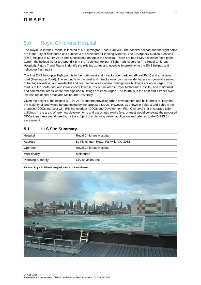
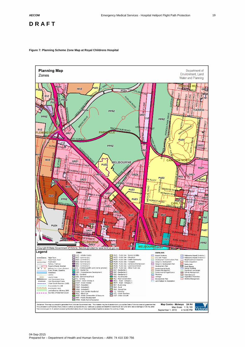
5.0 Royal Childrens Hospital
The Royal Childrens Hospital is located at 50 Flemington Road, Parkville. The hospital helipad and the flight paths
are in the City of Melbourne and subject to the Melbourne Planning Scheme. The Emergency Medical Services
(EMS) helipad is 62.4m AHD and is positioned on top of the hospital. There are four EMS helicopter flight paths
to/from the helipad (refer to Appendix B in the Technical Heliport Flight Path Report for The Royal Childrens
Hospital). Figure 7 and Figure 8 identify the existing zones and overlays in proximity to the EMS helipad and
helicopter flight paths.
The first EMS helicopter flight path is to the north-west and it tracks over parkland (Royal Park) and an arterial
road (Flemington Road). The second is to the west and it tracks over low-rise residential areas (generally subject
to heritage overlays) and residential and commercial areas where mid-high rise buildings are encouraged. The
third is to the south-east and it tracks over low-rise residential areas, Royal Melbourne Hospital, and residential
and commercial areas where mid-high rise buildings are encouraged. The fourth is to the east and it tracks over
low-rise residential areas and Melbourne University.
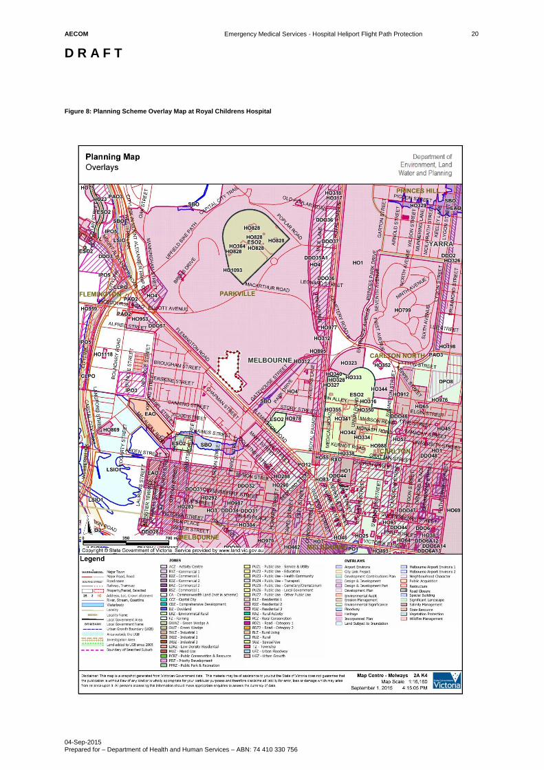
Given the height of the helipad (62.4m AHD) and the prevailing urban development and built form it is likely that
the majority of land would be unaffected by the proposed DDOs. However, as shown in Table 3 and Table 4 the
proposed DDOs intersect with existing overlays (DDOs and Development Plan Overlays) that encourage taller
buildings in the area. Where new developments and associated works (e.g. cranes) would penetrate the proposed
DDOs then these would need to be the subject of a planning permit application and referred to the DHHS for
assessment.
5.1 HLS Site Summary
Hospital Royal Childrens Hospital
Address 50 Flemington Road, Parkville VIC 3052
Operator Royal Childrens Hospital
Municipality Melbourne
Planning Authority City of Melbourne
Photo 4: Royal Childrens Hospital, view to the south-east
AECOM
Emergency Medical Services - Hospital Heliport Flight Path Protection
D R A F T
04-Sep-2015 Prepared for – Department of Health and Human Services – ABN: 74 410 330 756
18
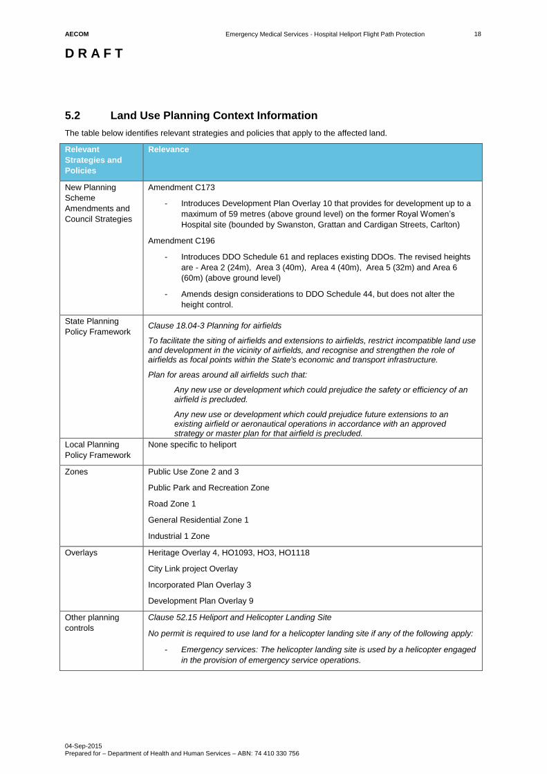
5.2 Land Use Planning Context Information
The table below identifies relevant strategies and policies that apply to the affected land.
Relevant
Strategies and
Policies
Relevance
New Planning
Scheme
Amendments and
Council Strategies
Amendment C173
- Introduces Development Plan Overlay 10 that provides for development up to a
maximum of 59 metres (above ground level) on the former Royal Women’s
Hospital site (bounded by Swanston, Grattan and Cardigan Streets, Carlton)
Amendment C196
- Introduces DDO Schedule 61 and replaces existing DDOs. The revised heights
are - Area 2 (24m), Area 3 (40m), Area 4 (40m), Area 5 (32m) and Area 6
(60m) (above ground level)
- Amends design considerations to DDO Schedule 44, but does not alter the
height control.
State Planning
Policy Framework Clause 18.04-3 Planning for airfields
To facilitate the siting of airfields and extensions to airfields, restrict incompatible land use and development in the vicinity of airfields, and recognise and strengthen the role of airfields as focal points within the State's economic and transport infrastructure.
Plan for areas around all airfields such that:
Any new use or development which could prejudice the safety or efficiency of an airfield is precluded.
Any new use or development which could prejudice future extensions to an existing airfield or aeronautical operations in accordance with an approved strategy or master plan for that airfield is precluded.
Local Planning
Policy Framework
None specific to heliport
Zones Public Use Zone 2 and 3
Public Park and Recreation Zone
Road Zone 1
General Residential Zone 1
Industrial 1 Zone
Overlays Heritage Overlay 4, HO1093, HO3, HO1118
City Link project Overlay
Incorporated Plan Overlay 3
Development Plan Overlay 9
Other planning
controls
Clause 52.15 Heliport and Helicopter Landing Site
No permit is required to use land for a helicopter landing site if any of the following apply:
- Emergency services: The helicopter landing site is used by a helicopter engaged
in the provision of emergency service operations.
AECOM
Emergency Medical Services - Hospital Heliport Flight Path Protection
D R A F T
04-Sep-2015 Prepared for – Department of Health and Human Services – ABN: 74 410 330 756
19
Figure 7: Planning Scheme Zone Map at Royal Childrens Hospital
AECOM
Emergency Medical Services - Hospital Heliport Flight Path Protection
D R A F T
04-Sep-2015 Prepared for – Department of Health and Human Services – ABN: 74 410 330 756
20
Figure 8: Planning Scheme Overlay Map at Royal Childrens Hospital
AECOM
Emergency Medical Services - Hospital Heliport Flight Path Protection
D R A F T
04-Sep-2015 Prepared for – Department of Health and Human Services – ABN: 74 410 330 756
21
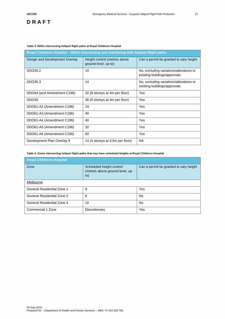
Table 3: DDOs intersecting heliport flight paths at Royal Childrens Hospital
Royal Childrens Hospital – DDOs intersecting and interfacing with heliport flight paths
Design and Development Overlay Height control (metres above
ground level, up to)
Can a permit be granted to vary height
DDO35.2 10 No, excluding variations/alterations to
existing buildings/approvals
DDO35.3 14 No, excluding variations/alterations to
existing buildings/approvals
DDO44 (and Amendment C196) 32 (8 storeys at 4m per floor) Yes
DDO45 36 (9 storeys at 4m per floor) Yes
DDO61-A2 (Amendment C196) 24 Yes
DDO61-A3 (Amendment C196) 40 Yes
DDO61-A4 (Amendment C196) 40 Yes
DDO61-A5 (Amendment C196) 32 Yes
DDO61-A6 (Amendment C196) 60 Yes
Development Plan Overlay 9 14 (4 storeys at 3.5m per floor) NA
Table 4: Zones intersecting heliport flight paths that may have scheduled heights at Royal Childrens Hospital
Royal Childrens Hospital
Zone Scheduled height control
(metres above ground level, up
to)
Can a permit be granted to vary height
Melbourne
General Residential Zone 1 9 Yes
General Residential Zone 2 8 No
General Residential Zone 4 10 No
Commercial 1 Zone Discretionary Yes
AECOM
Emergency Medical Services - Hospital Heliport Flight Path Protection
D R A F T
04-Sep-2015 Prepared for – Department of Health and Human Services – ABN: 74 410 330 756
22
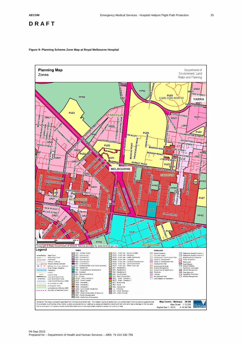
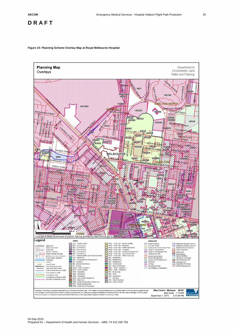
6.0 Royal Melbourne Hospital
The Royal Melbourne Hospital is located at 300 Grattan Street, Parkville. The hospital helipad and the flight paths
are in the City of Melbourne and subject to the Melbourne Planning Scheme. The Emergency Medical Services
(EMS) helipad is 67.3m AHD and is positioned on top of the hospital. There are two EMS helicopter flight paths
and one flight sector to/from the helipad (refer to Appendix B in the Technical Heliport Flight Path Report for The
Royal Melbourne Hospital). Figure 9 and Figure 10 identify the existing zones and overlays in proximity to the
EMS helipad and helicopter flight paths.
The first EMS helicopter flight path is to the west and the second to the east. The third is a flight sector to the
south-east. These flight paths track over low-rise residential areas (generally subject to heritage overlays),
residential and commercial areas where mid-high rise buildings are encouraged, and Melbourne University.
Given the height of the helipad (67.3m AHD) and the prevailing urban development and built form it is likely that
the majority of land would be unaffected by the proposed DDOs. However, as shown in Table 5 and Table 6 the
proposed DDOs intersect with existing overlays (DDOs and Development Plan Overlays) that encourage taller
buildings in the area. Where new developments and associated works (e.g. cranes) would penetrate the proposed
DDOs then these would need to be the subject of a planning permit application and referred to the DHHS for
assessment.
6.1 HLS Site Summary
Hospital Royal Melbourne Hospital
Address 300 Grattan Street, Parkville, VIC, 3050
Operator Melbourne Health
Municipality Melbourne
Planning Authority City of Melbourne
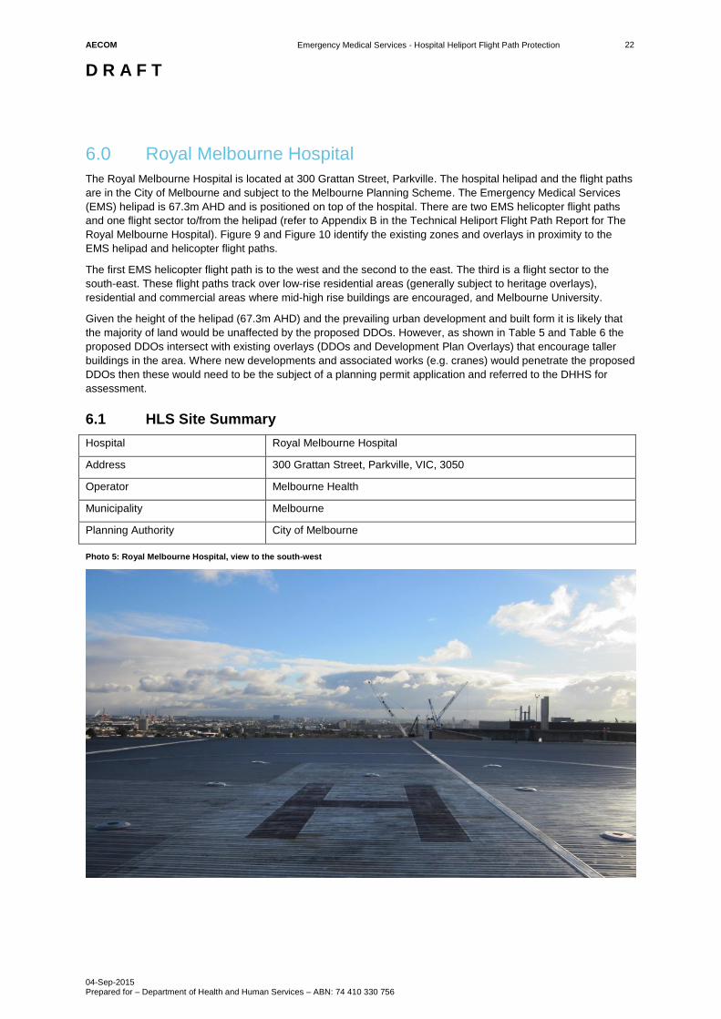
Photo 5: Royal Melbourne Hospital, view to the south-west
AECOM
Emergency Medical Services - Hospital Heliport Flight Path Protection
D R A F T
04-Sep-2015 Prepared for – Department of Health and Human Services – ABN: 74 410 330 756
23
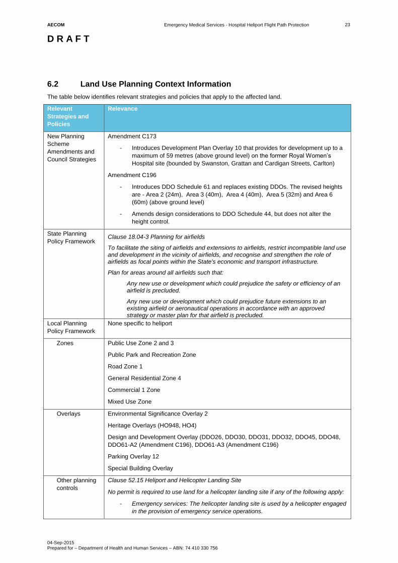
6.2 Land Use Planning Context Information
The table below identifies relevant strategies and policies that apply to the affected land.
Relevant
Strategies and
Policies
Relevance
New Planning
Scheme
Amendments and
Council Strategies
Amendment C173
- Introduces Development Plan Overlay 10 that provides for development up to a
maximum of 59 metres (above ground level) on the former Royal Women’s
Hospital site (bounded by Swanston, Grattan and Cardigan Streets, Carlton)
Amendment C196
- Introduces DDO Schedule 61 and replaces existing DDOs. The revised heights
are - Area 2 (24m), Area 3 (40m), Area 4 (40m), Area 5 (32m) and Area 6
(60m) (above ground level)
- Amends design considerations to DDO Schedule 44, but does not alter the
height control.
State Planning
Policy Framework Clause 18.04-3 Planning for airfields
To facilitate the siting of airfields and extensions to airfields, restrict incompatible land use and development in the vicinity of airfields, and recognise and strengthen the role of airfields as focal points within the State's economic and transport infrastructure.
Plan for areas around all airfields such that:
Any new use or development which could prejudice the safety or efficiency of an airfield is precluded.
Any new use or development which could prejudice future extensions to an existing airfield or aeronautical operations in accordance with an approved strategy or master plan for that airfield is precluded.
Local Planning
Policy Framework
None specific to heliport
Zones Public Use Zone 2 and 3
Public Park and Recreation Zone
Road Zone 1
General Residential Zone 4
Commercial 1 Zone
Mixed Use Zone
Overlays Environmental Significance Overlay 2
Heritage Overlays (HO948, HO4)
Design and Development Overlay (DDO26, DDO30, DDO31, DDO32, DDO45, DDO48,
DDO61-A2 (Amendment C196), DDO61-A3 (Amendment C196)
Parking Overlay 12
Special Building Overlay
Other planning
controls
Clause 52.15 Heliport and Helicopter Landing Site
No permit is required to use land for a helicopter landing site if any of the following apply:
- Emergency services: The helicopter landing site is used by a helicopter engaged
in the provision of emergency service operations.
AECOM
Emergency Medical Services - Hospital Heliport Flight Path Protection
D R A F T
04-Sep-2015 Prepared for – Department of Health and Human Services – ABN: 74 410 330 756
24
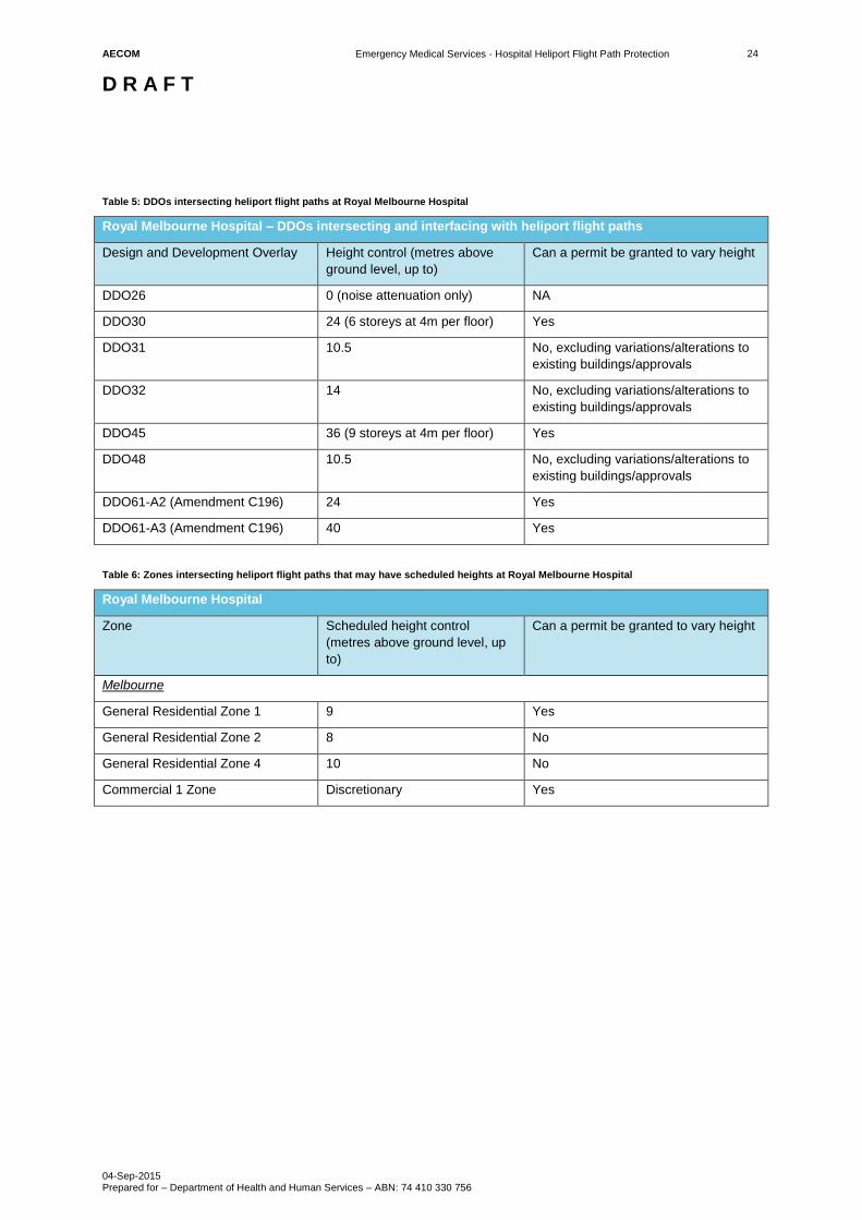
Table 5: DDOs intersecting heliport flight paths at Royal Melbourne Hospital
Royal Melbourne Hospital – DDOs intersecting and interfacing with heliport flight paths
Design and Development Overlay Height control (metres above
ground level, up to)
Can a permit be granted to vary height
DDO26 0 (noise attenuation only) NA
DDO30 24 (6 storeys at 4m per floor) Yes
DDO31 10.5 No, excluding variations/alterations to
existing buildings/approvals
DDO32 14 No, excluding variations/alterations to
existing buildings/approvals
DDO45 36 (9 storeys at 4m per floor) Yes
DDO48 10.5 No, excluding variations/alterations to
existing buildings/approvals
DDO61-A2 (Amendment C196) 24 Yes
DDO61-A3 (Amendment C196) 40 Yes
Table 6: Zones intersecting heliport flight paths that may have scheduled heights at Royal Melbourne Hospital
Royal Melbourne Hospital
Zone Scheduled height control
(metres above ground level, up
to)
Can a permit be granted to vary height
Melbourne
General Residential Zone 1 9 Yes
General Residential Zone 2 8 No
General Residential Zone 4 10 No
Commercial 1 Zone Discretionary Yes
AECOM
Emergency Medical Services - Hospital Heliport Flight Path Protection
D R A F T
04-Sep-2015 Prepared for – Department of Health and Human Services – ABN: 74 410 330 756
25
Figure 9: Planning Scheme Zone Map at Royal Melbourne Hospital
AECOM
Emergency Medical Services - Hospital Heliport Flight Path Protection
D R A F T
04-Sep-2015 Prepared for – Department of Health and Human Services – ABN: 74 410 330 756
26
Figure 10: Planning Scheme Overlay Map at Royal Melbourne Hospital
AECOM
Emergency Medical Services - Hospital Heliport Flight Path Protection
D R A F T
04-Sep-2015 Prepared for – Department of Health and Human Services – ABN: 74 410 330 756
27
7.0 Warragul Hospital
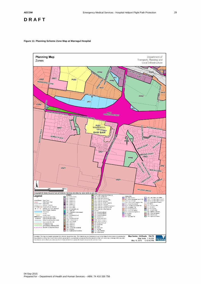
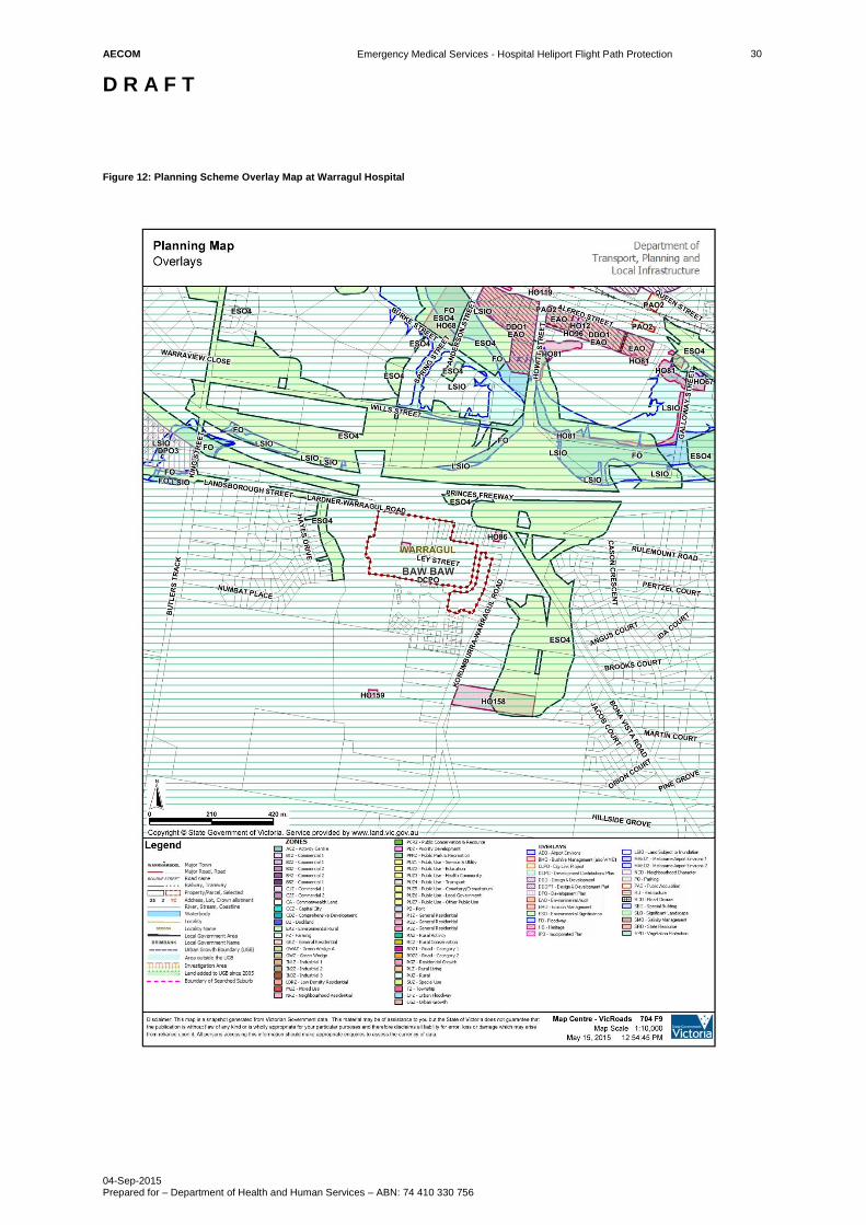
The Warragul Hospital is located at 41 Landsborough Street, Warragul. It is within the Shire of Baw Baw and
subject to the Baw Baw Planning Scheme. The EMS helipad is 145m AHD and it sits on a hill generally above the
surrounding land. By comparison, the land to the south and north (for approximately 500 metres along the flight
path sector) is at a lower elevation of between 110 and 130 metres AHD. There are two EMS helicopter flight path
sectors to/from the helipad (refer to Appendix B in the Technical Heliport Flight Path Report for The Warragul
Hospital). Figure 1 and Figure 2 identify the existing zones and overlays in proximity to the EMS helipad and
helicopter flight paths.
The first EMS helicopter flight path is to the north-west. It tracks over the hospital, Princes Freeway, land
restricted by the Urban Flood Zone, industrial areas, parkland (Burke Street Park) and Warragul Regional
College. The second is to the south-west. It tracks over a tertiary education facility (Community College Gippsland
- McMillan Campus) and land currently used for agricultural purposes but which was recently rezoned to Urban
Growth Zone 1 to encourage urban (primarily residential) uses.
Given the height of the helipad vis-à-vis the topography of the land to the north-east, trajectory of the helicopter
and the distance to affected land, it is likely that the majority of land would be unaffected by the proposed DDOs.
Given the proposed development of land to the south-east, the height of the helipad vis-à-vis the topography of
the land, trajectory of the helicopter and proximity to the affected land it is possible that land would be affected by
the proposed DDOs. Developers and Councils will need to consider on a case-by-case basis whether proposed
buildings, structures and associated works (e.g. scaffolding, plant and equipment) penetrate the DDOs.
In other words, is the maximum height of any buildings, structures and associated works 145.4m AHD or above
within the inner DDO (up to 460 metres from the helipad), or 155.4m AHD or above within the outer DDO
(between 460 metres and 1130 metres from the helipad). Where new developments and associated works (e.g.
cranes) would penetrate the proposed DDOs then these would need to be the subject of a planning permit
application and referred to the DHHS for assessment.
7.1 HLS Site Summary
Hospital Warragul Hospital
Address 41 Landsborough Street, Warragul, Victoria
Operator West Gippsland Healthcare Group
Municipality Baw Baw
Planning Authority Shire of Baw Baw
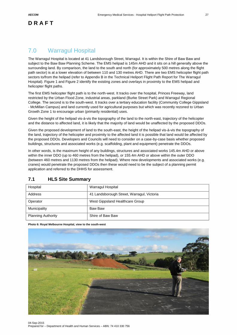
Photo 6: Royal Melbourne Hospital, view to the south-west
AECOM
Emergency Medical Services - Hospital Heliport Flight Path Protection
D R A F T
04-Sep-2015 Prepared for – Department of Health and Human Services – ABN: 74 410 330 756
28
7.2 Land Use Planning Context Information
The table below identifies relevant strategies and policies that apply to the affected land.
Relevant
Strategies and
Policies
Relevance
New Planning
Scheme
Amendments and
Council Strategies
The Warragul Precinct Structure Plan (PSP) was the basis for rezoning land to the south
of the helipad to Urban Growth Zone. This area is to be developed for residential land
uses. Heights are not specified in the PSP, but are unlikely to exceed 9 metres (as per
the default building height in the General Residential Zone)
State Planning
Policy Framework Clause 18.04-3 Planning for airfields
To facilitate the siting of airfields and extensions to airfields, restrict incompatible land use and development in the vicinity of airfields, and recognise and strengthen the role of airfields as focal points within the State's economic and transport infrastructure.
Plan for areas around all airfields such that:
Any new use or development which could prejudice the safety or efficiency of an airfield is precluded.
Any new use or development which could prejudice future extensions to an existing airfield or aeronautical operations in accordance with an approved strategy or master plan for that airfield is precluded.
Local Planning
Policy Framework
None specific to heliport
Zones Public Use Zone 3
Public Park and Recreation Zone
Road Zone 1
General Residential Zone 1
Urban Growth Zone 1
Urban Flood Zone
Overlays Development Contribution Plan Overlay
Environmental Significance Overlay 4
Heritage Overlay 87
Other planning
controls
Clause 52.15 Heliport and Helicopter Landing Site
No permit is required to use land for a helicopter landing site if any of the following apply:
- Emergency services: The helicopter landing site is used by a helicopter engaged
in the provision of emergency service operations.
AECOM
Emergency Medical Services - Hospital Heliport Flight Path Protection
D R A F T
04-Sep-2015 Prepared for – Department of Health and Human Services – ABN: 74 410 330 756
29
Figure 11: Planning Scheme Zone Map at Warragul Hospital
AECOM
Emergency Medical Services - Hospital Heliport Flight Path Protection
D R A F T
04-Sep-2015 Prepared for – Department of Health and Human Services – ABN: 74 410 330 756
30
Figure 12: Planning Scheme Overlay Map at Warragul Hospital