Embed Size (px)
Citation preview

Embedded LINUX in a Soft Real-Time Task:The Canadian Geological Survey Internet
Seismometer
c© Sept 2001 ∗
9-01
Contents
1 Summary 2
2 Background 3
3 The GSC-PGC embedded LINUX Accelerometer 5
4 Acceleration Sensors 6
5 A network friendly, soft-real-time operating system 7
6 Current developments 9
7 Instrument Specifications 10
8 Selected Links 138.1 Seismology . . . . . . . . . . . . . . . . . . . . . . . . . . . . . . . 138.2 Embedded Systems and LINUX. . . . . . . . . . . . . . . . . . . . 13
1

1 Summary
Arescon ltd. developed the real-time software and an embedded operating system fora new type of three-component accelerometer for the Canadian government. The ac-celerometer is a prototype instrument for the proposed Canadian Urban SeismologyProject (CUSP).
Several hundred of these instruments are to be deployed in urban centers through-out the Canadian high-seismic-hazard regions.
The instrument incorporates an Internet data server and an automatic event param-eter reporting system. Aside from strong-motion and engineering seismic research, thedense network of instruments will provide real-time data for disaster response servicesduring and immediately after a substantial earthquake.

2 Background
Seismology as a science is traditionally focused on the question how earthquakesoccur, what their sources are and if there is any way to predict where and when anearthquake will occur, as well as it is now possible to predict the weather over the nextdays, weeks or even month.
While our understanding of thesources of earthquakes and the dy-namic processes in the earth’s crusthas taking large steps over the lastcentury, advances in earthquake pre-diction, in the sense of forecastingtheir onset, have been rather disap-pointing.
On the other hand, techniques toassess thepotential risk that a par-ticular building, a house, a hydro-dam or a bridge may be damagedduring an earthquake provide a valu-able bases to prepare for the after-math of a large earthquake. Insur-ance companies use those risk as-sessments to calculate their earthquakeinsurance premiums and engineersneed the same kind of informationto design buildings which can with-
stand the shaking of the largest earthquake which canprobablyoccur in a particularlocation.
In simple terms, earthquake hazard and risk assessment tells you what the chancesare that you are struck by an earthquake of a certain magnitude and what the worst casescenario you should prepare for, may look like.
Earthquake hazard assessments are largely based on a good knowledge of the sourcesand defining tectonic structures in the region as well as on statistical analysis of historicdata. Here the general idea is, that the likelihood that a particular place will be affectedby an earthquake is based on the sequence of quakes that have affected that particularplace in the past. Since our instrumental record of past earthquakes is rather short incomparison to the times over which tectonic features evolve, the statistical assessmentalone is often difficult and unreliable.
Additionally scientists and engineers started to realize more recently, that hazardassessment which is focused only on the earthquake sources, does not tell the whole

story. The actual earthquake damage sustained by structures in a larger city for exam-ple showed a rather complex pattern and the effects of earthquakes of even moderatemagnitudes would actually vary widely over the distance of a few city-blocks [7].
Traditional earthquake hazard maps do not have that kind of resolution since localeffects which can actually amplify (or attenuate) ground motion triggered by an earth-quake, could only be accounted for in a limited way.
These local effects are in general related to the geological structure of the imme-diate subsurface and the topography of an affected area. While geo-technical modelsexist which can explain amplification and attenuation of seismic waves depending onthe local subsurface, it was soon recognized, that those effects should actually be di-rectly measured.
A good (and rare) example of a highly detailed earthquake hazard map for thegreater Victoria Area (British Columbia, Canada) can be found under
“http://www.em.gov.bc.ca/Mining/Geolsurv/Surficial/hazards/default.htm”.
Amplification effects appear to be non linearly dependent on the amplitude of theoriginal excitation and actual measurements are very much needed to fine-tune predic-tion models.
A further complication and a directly related problem is the prediction of the actualdamage the local shaking my cause to a particular building [5], since this “is a complexfunction of amplitude, frequency, and duration, and varies with the structure or com-ponent being considered” [9].
While a world-wide network of only a few hundred, highly sensitive instruments issufficient, to detect, record and localize almost any significant earthquake on earth, itis quite obvious, that in order to study the highly localizedeffectsof an earthquake ondensely populated areas, a very dense network of instruments would be required.
Additionally, those instruments would, rather than being extremely sensitive, haveto be able to record very strong and violent ground motion and survive an actual earth-quake themselves.
Instruments of this kind, are calledstrong motionseismometers and a variety ofthem is commercially available. For a dense station network of several hundred instru-ments, however, current strong motion seismometers are not ideally suited. They lackbuilt-in communication capabilities which would allow data to be retrieved remotely.
How important these communication capabilities are, becomes apparent if theseinstruments are also to be used as real-time sensors in an actual major earthquake inorder to provide a basis of reconnaissance for the emergency response teams. In orderto respond to a major earthquake disaster the limited resources of fire fighters, ambu-lances and other disaster relief crews have to be prioritized.

A dense network of strong motion seismometers in an urban area could provide thedata for the generation of a shake map which could, within minutes after the event,direct disaster response teams to the most affected areas within a city and save ex-tremely valuable time, which would otherwise be needed to first assess the situation.The Taiwan Central Weather Bureau’s Seismic Network [10] [11] and the SouthernCalifornia TriNet [3] have successfully implemented the generation of shake-mapsbased on strong-motion instrument networks. Japan operates the Kyoshin strong mo-tion network[6] with about 1000 seismic stations since 1996.
With the perspective to an application as a system for instant damage estimation itis evident, that a seismic station within such a network has to be completely self con-tained, robust, and be able to establish data communication with a central facility in(almost) real time.
Practical considerations also mandate, that each individual instrument can be mon-itored and serviced remotely. If up to 300 instruments are deployed in a city likeVancouver alone, it is practically impossible to attend to each individual instrument onsite in order to change parameters of the acquisition or to download data from a seismicevent.
3 The GSC-PGC embedded LINUX Accelerometer
In perspective, the Geological Survey of Canada plans to deploy a great number ofstrong-motion seismometers in the urban areas of Canada’s seismic risk areas [2] wereat the same time a well developed Internet infrastructure is already in place.
In order to take advantage of this communications infrastructure a digital strongmotion seismometer was designed at the Pacific Geoscience Center and was matedwith an Internet data server so that data from an instrument can be retrieved via stan-dard Internet protocols.
Arescon ltd. in Sidney, B. C., Canada was contracted to design the data acquisitionsoftware and the communications and data server package.
Normally the instrument acquires continuous acceleration data from the three or-thogonal sensors and stores five minute blocks in a file system which is accessible overthe Internet. This file system can hold data from about two and a half days and is per-manently updated.
Additionally, velocity, displacement [4] and certain spectral properties [5] are con-tinuously calculated as well. As soon as the instrument detects a seismic signal, para-metric data, such as peak ground acceleration, velocity and displacement together with

spectral intensity data are reported in a message send to central computer.
In the hardware design,
Figure 1: Two Internet Accelerometers in the Lab
the distinction between dataacquisition system and dataserver is somewhat artifi-cial. An embedded com-puter, in the current designthe Intel compatible JUMP-tech ETX/MGX single boardcomputer, is used to per-form part of a digital signal-processing chain for the datafrom the accelerometers aswell as to provide data stor-age and access to data bythe standard File TransferProtocol (FTP). The com-
puter runs under the free Open-Source operating system LINUX in a small and veryspecialized (embedded) version which also was designed byarescon ltd. from severaldifferent sources (see8).
4 Acceleration Sensors
Most existing strong motion seismometers use electromechanical “force feedback”sensors to measure ground acceleration. While these instruments have very desirablecharacteristics like the coupled pendulum instrument developed by [8] for example,they are expensive due to the complex manufacturing of the electro-mechanical sen-sors in rather small production numbers.
With current technology it is possible to manufacture micro-machined solid-stateacceleration sensors in larger quantities and a study by the U.S. Geological Survey hasshown [1], that rather sensitive seismometers can be built using these sensors.
The accelerometer hardware, which was designed by Ken Berverley at the PacificGeoscience Center (PGC) in Sidney, British Columbia, also employs micro machinedacceleration sensors. While the sensors used here are less sensitive than the ones stud-ied by [1], they are in turn produced in very large quantities as parts of airbag triggeringdevices for the car industry. They are consequently relatively cheap.
The instrument is designed to measure acceleration in three orthogonal directions.For each of the sensing directions four accelerometer chips are operated in parallel toimprove overall noise performance. The current design exhibits a sensitivity of0.5mg(with g the earth’ gravitational acceleration). For comparison: The average person

senses ground acceleration from an earthquake when it reaches about15 mg.
Recordings from a sim-
16 16.2 16.4 16.6 16.8 17 17.2 17.4 17.6 17.8 18−8
−6
−4
−2
0
2
4
6x 10
5 SSA2, Etna vs IA
Time [s]
Am
plitu
de [c
ount
s]
Figure 2: Comparing the Internet accelerometer (middletrace) with two different commercial instruments in asimulation of the 1992 Landers earthquake.
ulation of the Landers (Cal-ifornia 1992) earthquake areshown in figure1. We hadmounted several Internet ac-celerometers and four com-mercial strong-motion seis-mometers (Kinemetrics Etnaand SSA2) on a large shake-table when several brick wallelements were tested withrespect to their earthquakeresistance by the engineer-ing group of Prof. CarlosVentura (University of BritishColumbia, Dept. of Me-chanical Engineering).Themiddle trace in figure1wasrecorded by one of the In-ternet accelerometers, up-per and lower traces are froma Kinemetrics SSA2 and Etnastrong motion seismome-ter respectively. The record-ings compare well, differ-ences at higher frequenciesare due to the fact that theinstruments could not be mountedall in the same location on
the shake-table.
5 A network friendly, soft-real-time operating system
The output from the sensor packs is digitized by a 16-bit A/D converter and digitallyfiltered (decimated) in a first stage before it is passed on to the single board computerwhich is an integral part of the data acquisition system and also implements the data-and communications server for the instrument. The sensitivity of the digitization isultimately equivalent to 18 bits due to oversampling and a two-stage decimation filter.
The single board computer runs a multi-threaded processing and acquisition soft-ware which also was devised byarescon ltd. under LINUX, an Open-Source, freeoperating system.
While LINUX was initially not designed to meet the challenge of a real-time oper-ating system, it proved to be very well suited to provide the scheduling of processingand acquisition task with sufficient accuracy for this particular application. LINUXhandles program tasks which – while running independently – still have to communi-cate with one another, very well since it implements much of the functionality of thePOSIX standard, in particular a subset of the POSIX-Timers and POSIX-Threads sys-tem libraries.
Since, for the purpose of lim-
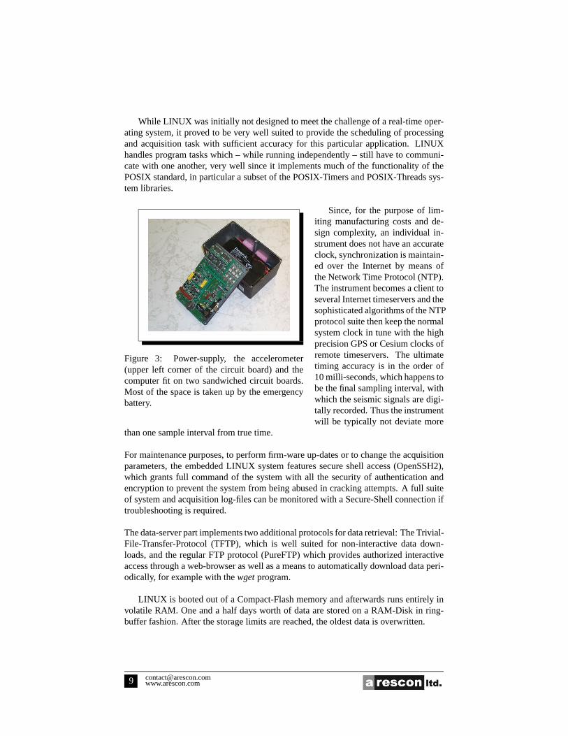
Figure 3: Power-supply, the accelerometer(upper left corner of the circuit board) and thecomputer fit on two sandwiched circuit boards.Most of the space is taken up by the emergencybattery.
iting manufacturing costs and de-sign complexity, an individual in-strument does not have an accurateclock, synchronization is maintain-ed over the Internet by means ofthe Network Time Protocol (NTP).The instrument becomes a client toseveral Internet timeservers and thesophisticated algorithms of the NTPprotocol suite then keep the normalsystem clock in tune with the highprecision GPS or Cesium clocks ofremote timeservers. The ultimatetiming accuracy is in the order of10 milli-seconds, which happens tobe the final sampling interval, withwhich the seismic signals are digi-tally recorded. Thus the instrumentwill be typically not deviate more
than one sample interval from true time.
For maintenance purposes, to perform firm-ware up-dates or to change the acquisitionparameters, the embedded LINUX system features secure shell access (OpenSSH2),which grants full command of the system with all the security of authentication andencryption to prevent the system from being abused in cracking attempts. A full suiteof system and acquisition log-files can be monitored with a Secure-Shell connection iftroubleshooting is required.
The data-server part implements two additional protocols for data retrieval: The Trivial-File-Transfer-Protocol (TFTP), which is well suited for non-interactive data down-loads, and the regular FTP protocol (PureFTP) which provides authorized interactiveaccess through a web-browser as well as a means to automatically download data peri-odically, for example with thewgetprogram.
LINUX is booted out of a Compact-Flash memory and afterwards runs entirely involatile RAM. One and a half days worth of data are stored on a RAM-Disk in ring-buffer fashion. After the storage limits are reached, the oldest data is overwritten.

When the instrument is initially deployed at a site it is configured by connectinga terminal (VT100) to its serial port. Thus, the network configuration and the stationidentifiers can be set for example, by simply connecting a Palm-Pilot to the instrument.
The currently implemented data-formats are the Canadian National SeismographicNetwork CA-format or as an option, the IRIS (Incorporated Research Institutions forSeismology) miniSEED format. A multicolumn ASCII format is also available.
6 Current developments
Efficient ways to integrate a large number of strong motion Internet accelerometers intothe existing network of broad-band and short-period seismometers are currently beinginvestigated.
PGC andarescon ltd. hope to deploy the first batch of about fifty instruments inthe Vancouver area by summer 2002.

7 Instrument Specifications
Sensor: Each axis has four ADXL105 iMeMS accelerometer chips connected in par-allel (to reduce noise and enhance linearity)
Full-scale:±4g
Noise: 0.5mg RMS, DC to42 Hz
Bandwidth: DC to42 Hz (set by 151 coefficient FIR filter)
Sample Rate:100 samples per second, optional 50, 60, 75, 150, 300.
Total instrument delay: 685ms due to a two-stage FIR filter implementation.Nonlinearity: 0.2% of full scale.
Temperature Sensitivity: less than±0.5% change over the operating temperaturerange.
Cross-Axis Sensitivity:±1%Alignment Error: ±1 degree
Zero-Adjust: none needed, provided the instrument is installed level.
Operating Temperature: −20 to +50 degrees C
Power Consumption: 8.1 W max at+9 V to +18 V DC, 5.7 W typical when theinternal Battery is fully charged.
Built-in UPS: More than 6 h run time with internal 6 V lead-acid battery.
Computer: National Semiconductor Geode, 266 MHz, 128 Mb RAM, 16 Mb Flashdisk. Optional 32 Mb up to 512 Mb Flash disk.
Operating System:Linux, Kernel 2.2.16
Data Format: Standard CNSN 5 minute CA data files, optional 5 minute miniSEEDor ASCII data files.
Timing Accuracy: ±10ms, assuming reasonable access to NTP-servers.
Total Data Time Lag: 685 ms, due to FIR filter length.
Data Retrieval: Via FTP or TFTP, the 80 Mb RAM disk stores about 2.5 days of data.

Internet security: password protection for FTP access, secure shell access for main-tenance.
Connectors:DB9-Female: Serial port to set up configuration parameters, RJ-45 10baseTEthernet, 2.1 mm female for 12 V , 1.5 A regulated power supply.
Indicators: Heartbeat / diagnostic LED, Ethernet activity LED.
Physical: Hammond 1590EBK case, 7.4” x 4.7” x 3.1” high.
Mounting: Case should be cemented to the basement floor using “plaster of Paris”(recommended, since it makes leveling easier) or bolted down through a hole drilled inthe case.

References
[1] J.R. Evans. The design and performance of a low-cost strong-motion sensor usingthe ics-3028 micromachined accelerometer. Technical report, U.S. Geol. Surv.,1998.
[2] GSC. CUSP: Canadian urban seismology program. Draft Proposal, August 2000.National Earthquake Hazards Program, Geol. Surv. of Canada.
[3] Egill Hauksson, Patrick Small, Katrin Hafner, Robert Busby, Robert Clayton,James Goltz, Tome Heaton, Kate Hutton, Hiroo Kanamori, Jascha Polet, DougGiven, Lucile M. Jones, and David Wald. Southern california seismic network:Caltech/usgs element of trinet 1997–2001.Seism. Res. Lett., 72(6):690 – 704,2001.
[4] Hiroo Kanamori, Philip Maechling, and Egil Hauksson. Continuous monitoringof ground-motion parameters.Bull. Seism. Soc. Am., 89(1):311–316, 1999.
[5] T. Katayama, N. Sato, and K. Saito. Si-sensor for the identification of destructiveground motion. InProceedings, Ninth World Conference on Earthquake Engi-neering, volume VII, pages 667–672, August Tokyo-Kyoto, 1988.
[6] S. Kinoshita. Kyoshin net (k-net).Seism. Res. Lett., 1998.
[7] P.A. Monahan, V.M. Levson, P.Henderson, and A. Sy. Geoscience map 1998-6;amplification of ground motion and liquefaction hazard map of greater victoria:Report and expanded legend. Technical report, British Columbia Geol. Surv.,1998.
[8] I. Muramatsu, T Sasatani, and I.Yokoi. Velocity-type strong-motion seismometerusing a coupled pendulum: Design and performance.Bull. Seism. Soc. Am., 2001.
[9] L. Reiter.Earthquake Hazard Analysis. Coumbia University Press, N.Y., 1991.
[10] T. Teng, Tzay-Chyn Shin Ludan Wu, Yi-Ben Tsai, and William H. K. Lee. Oneminute after: Strong-motion map, effective epicenter, and effective magnitude.Bull. Seism. Soc. Am., 87(5):1209–1219, 1997.
[11] Y. Wu, W.H.K. Lee, C. Chen, T. Shin, T. Teng, and Y.Tsai. Performance of thetaiwan rapid earthquake information release system (rtd) during the 1999 chi-chi(taiwan) earthquake.Seism. Res. Lett., 2000.

8 Selected Links
8.1 Seismology
An example of an earthquake hazard map for the greater Victoria, B.C. (Canada) areacan be found at:
http://www.em.gov.bc.ca/Mining/Geolsurv/Surficial/hazards/default.htm.
One of the most elaborate strong motion seismic networks is Kyoshin Net (K-Net) inJapanhttp://www.k-net.bosai.go.jp
The TriNet projecthttp://www.trinet.org/shake/has examples of actual shake-mapsfrom recent earthquakes.
The IRIS consortium (Incorporated Research Institutions for Seismology) is athttp://www.iris.washington.edu.
The home page of the Pacific Geoscience Center ishttp://www.pgc.nrcan.gc.ca.
8.2 Embedded Systems and LINUX
General information about LINUX is athttp://www.linux.org
A good overview over pre-cooked embedded LINUX systems as well as pointers totools to “roll your own” is underhttp://linux-embedded.com.
An extremely useful software package which can be found in almost any small LINUXsystems is the busyboxhttp://www.busybox.net.
A good and pretty straight forward small LINUX system designed for network analysisand troubleshooting is:
http://trinux.sourceforge.net.The Trinux boot and start-up scheme is built exclusively on shell scripts which canserve as an excellent tutorial on how to get things up and running.
The Open-Source secure shell project is at home underhttp://www.openssh.com.
The home-page of Open-Source pureFTP project ishttp://www.pureftp.org.