Embed Size (px)
Citation preview

Ellerslie Care Home, Albert Road
Site Reference: CP066 STATUS: G
Site area: 0.6 ha
Ward: Pittville Land use: Brownfield
Current use: Residential Site identification: Submitted
Planning history: 13/01861/FUL 14 homes - granted. Appeal dismissed December 2014 on revised scheme - 14/00629/FUL
Site character: Urban / developed
Designations:
Description and analysis This is a flat, developed, site is within a predominantly residential area and adjacent to Pittville Park and within the Central Conservation area. The site was previously used as a Care Home and planning permission has been granted for the conversion of the existing building and associated stable block to provide 14 residential units.
Should the planning permission not be implemented then this site could be reconsidered. See also site S098, Land adjacent to Ellerslie which has been submitted as a separate site.
The site is in an accessible location with the majority of facilities being within 5 minutes by car, except for ACCIDENT AND EMERGENCY / MINOR INJURIES UNIT which is between 5 - 15 minutes. Access to facilities from the site by bus or walking is good for the majority of facilities, being under 15 minutes, however access to a supermarket, children's centre and ACCIDENT AND EMERGENCY / MINOR INJURIES UNIT is fair, being 15 - 30 minutes.
The SALA assesses the site as suitable, available and achievable for housing, within 5 years, and suitable for economic uses.

Prestbury Road / Windsor Street 1
Site Reference: CP067 STATUS: R
Site area: 0.9 ha
Ward: Pittville Land use: Brownfield
Current use: Commercial / industry Site identification: Officer identified
Planning history: Informal guidance note 2008 Site character: Urban / developed
Designations: Contamination, Flood Zone 2 (Part),
Flood Zone 3 (Part),
Description and analysis This is a flat brownfield site in a predominantly residential area within the urban area. There is existing employment/commercial use on site and an informal concept statement identifies the potential for mixed housing and employment use. There are neighbouring locally listed properties and listed buildings, a culvert runs through site and there is the potential for contaminated land. The site is partially within Flood Zones 2 and 3.
The site has good accessibility to a range of facilities by car (under 5 minutes), bus or walking (under 15 minutes) with the exception of access to ACCIDENT AND EMERGENCY / MINOR INJURIES UNIT by bus or walking which is between 15 - 30 minutes.
The SALA assesses the site as suitable for housing and economic uses

Prestbury Road / Windsor Street 2
Site Reference: CP068 STATUS: R
Site area: 0.16 ha
Ward: Pittville Land use: Brownfield
Current use: Commercial / industry Site identification: Officer identified
Planning history: Informal guidance note 2008 Site character: Urban / developed
Designations: Contamination, Flood Zone 2 (Part),
Flood Zone 3 (Part),
Description and analysis This is a flat brownfield site in predominantly residential area within the urban area. There is existing employment/commercial use on the site and an informal concept statement identifies the potential for mixed housing and employment use. There are nNeighbouring locally listed properties and listed buildings, there is potential for contaminated land.
The site has good accessibility to a range of facilities by car (under 5 minutes), bus or walking (under 15 minutes) with the exception of access to ACCIDENT AND EMERGENCY / MINOR INJURIES UNIT by bus or walking which is between 15 - 30 minutes.
The SALA assesses the site as suitable for housing and economic uses.

Cakebridge Place
Site Reference: CP069 STATUS: R
Site area: 0.6 ha
Ward: Oakley Land use: Brownfield
Current use: Residential Site identification: Officer identified
Planning history: N/A Site character: Urban / developed
Designations: Flood Zone 2, Flood Zone 3,
Description and analysis The site is a flat, developed, site within the urban area containing pre-fabricated bungalows. The surrounding area is predominantly residential with commercial/employment uses to the west and Cheltenham Town Football Club to the south east. The site falls within Flood Zones 2 & 3. The site is subject to a 'land swap' with the Football Club car park which will allow for the development of residential development outside of the flood risk area. The redevelopment on land at Whaddon Road would provide a total of 16 houses which would provide a net gain of 7. Redevelopment of this site would be as a car park use for the Football Club.
The site has good accessibility to a range of facilities by car (under 5 minutes), bus or walking (under 15 minutes) with the exception of access to ACCIDENT AND EMERGENCY / MINOR INJURIES UNIT by bus or walking which is between 15 - 30 minutes.
The SALA assesses the site as not suitable, available and achievable for housing or economic uses
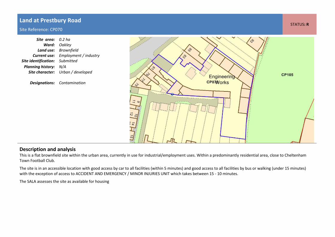
Land at Prestbury Road
Site Reference: CP070 STATUS: R
Site area: 0.2 ha
Ward: Oakley Land use: Brownfield
Current use: Employment / industry Site identification: Submitted
Planning history: N/A Site character: Urban / developed
Designations: Contamination
Description and analysis This is a flat brownfield site within the urban area, currently in use for industrial/employment uses. Within a predominantly residential area, close to Cheltenham Town Football Club.
The site is in an accessible location with good access by car to all facilities (within 5 minutes) and good access to all facilities by bus or walking (under 15 minutes) with the exception of access to ACCIDENT AND EMERGENCY / MINOR INJURIES UNIT which takes between 15 - 10 minutes.
The SALA assesses the site as available for housing
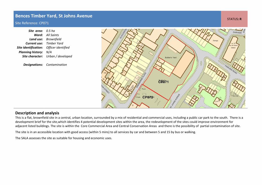
Bences Timber Yard, St Johns Avenue
Site Reference: CP071 STATUS: R
Site area: 0.5 ha
Ward: All Saints Land use: Brownfield
Current use: Timber Yard Site identification: Officer identified
Planning history: N/A Site character: Urban / developed
Designations: Contamination
Description and analysis This is a flat, brownfield site in a central, urban location, surrounded by a mix of residential and commercial uses, including a public car park to the south. There is a development brief for the site,which identifies 4 potential development sites within the area, the redevelopment of the sites could improve environment for adjacent listed buildings. The site is within the Core Commercial Area and Central Conservation Areas and there is the possibility of partial contamination of site.
The site is in an accessible location with good access (within 5 mins) to all services by car and between 5 and 15 by bus or walking.
The SALA assesses the site as suitable for housing and economic uses.

Sherborne Place Car Park
Site Reference: CP072 STATUS: R
Site area: 0.2 ha
Ward: All Saints Land use: Brownfield
Current use: Car Park Site identification: Officer identified
Planning history: N/A Site character: Urban / undeveloped
Designations: Contamination
Description and analysis It is a flat previously developed site currently being used as a town centre car park that is surrounding by a mix of residential and commercial uses. There is an existing Development Brief for the site that identifies opportunities for wider redevelopment to improve environment. The site is situated within Core Commercial Area and Central Conservation Area as defined within the adopted Local Plan. Possibly contamination on part of the site. The site is in an accessible location with good access (within 5 mins) to all services by car and between 5 and 15 by bus or walking.
The SALA assesses the site as suitable for housing and economic uses.
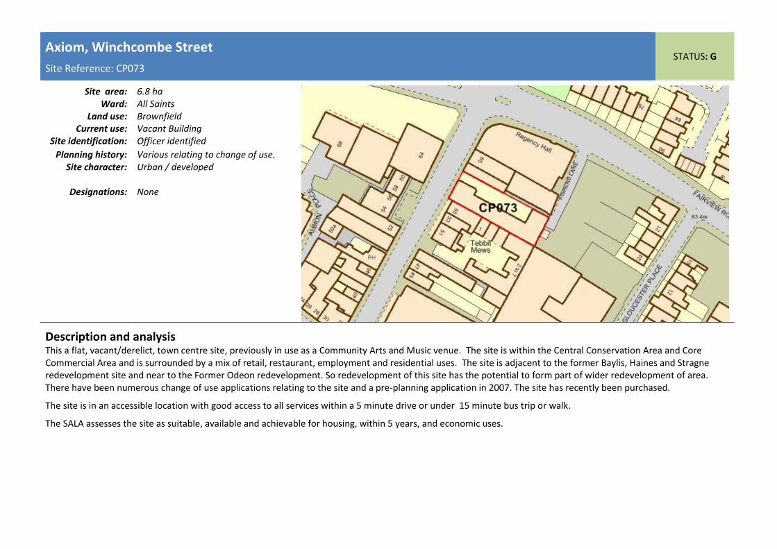
Axiom, Winchcombe Street
Site Reference: CP073 STATUS: G
Site area: 6.8 ha
Ward: All Saints Land use: Brownfield
Current use: Vacant Building Site identification: Officer identified
Planning history: Various relating to change of use. Site character: Urban / developed
Designations: None
Description and analysis This a flat, vacant/derelict, town centre site, previously in use as a Community Arts and Music venue. The site is within the Central Conservation Area and Core Commercial Area and is surrounded by a mix of retail, restaurant, employment and residential uses. The site is adjacent to the former Baylis, Haines and Stragne redevelopment site and near to the Former Odeon redevelopment. So redevelopment of this site has the potential to form part of wider redevelopment of area. There have been numerous change of use applications relating to the site and a pre-planning application in 2007. The site has recently been purchased.
The site is in an accessible location with good access to all services within a 5 minute drive or under 15 minute bus trip or walk.
The SALA assesses the site as suitable, available and achievable for housing, within 5 years, and economic uses.

Rodney Road Car Park, Rodney Road
Site Reference: CP074 STATUS: R
Site area: 0.2 ha
Ward: College Land use: Brownfield
Current use: Car Park Site identification: Officer identified
Planning history: N/A Site character: Urban / developed
Designations: Flood Zone 2, Flood Zone 3 (Part),
Description and analysis It is a flat brownfield site currently being used as a town centre car park that is surrounding by a mix of uses. The site is situated within the Core Commercial Area, Central Conservation Area, as defined within the adopted Local Plan, and Flood Zones 2 and 3. The site is in an accessible location with good access (within 5 mins) to all services by car and between 5 and 20 by bus or walking.
The SALA assesses the site as suitable for housing and economic uses.

Royal Well & Municipal Offices
Site Reference: CP075 STATUS: G
Site area: 0.9 ha
Ward: Lansdown Land use: Brownfield
Current use: Employment / Bus station/ residential
Site identification: Officer identified
Planning history: Royal Well Development Brief Site character: Urban / developed
Designations: Contamination (small part), Flood
Zone 2, Flood Zone 3 (Part)
Description and analysis This is a flat, developed site within the town centre, currently in use as council offices, bus station, car park and area of open space. Site is identified within Civic Pride SPD and has a development brief which identifies potential for existing uses to be relocated/redesigned.
The site is within the Core Commercial Area and Central Conservation Area and partially within Flood Zones 2 & 3. The municipal offices are listed.
Redevelopment of the site is being progressed through Cheltenham Development Taskforce.
The site is in an accessible location with good access to all facilities by car (under 5 minutes) and good access to the majority of facilities by bus or walking (under 15 minutes) with the exception of a children's centre and ACCIDENT AND EMERGENCY / MINOR INJURIES UNIT which takes between 15 - 30 minutes.
The SALA assesses the site as suitable, available and achievable for housing, within 6 - 10 years, and economic uses

St Georges House, Bayshill Road
Site Reference: CP076 STATUS: G
Site area: 0.4 ha
Ward: Lansdown Land use: Brownfield
Current use: Vacant Office Building Site identification: Submitted
Planning history: 13/01751/FUL 48 extra care apartments (C2)- Granted
Site character: Urban / developed
Designations: None
Description and analysis This is a flat, developed site within the town centre, currently vacant but previously in office use. The site is within the Core Commercial Area and Central Conservation area and contains listed buildings.
The site is in an accessible location being under 15 minutes of all major services by foot and bus.
The site has planning approval for 48 extra care apartments (C2) (13/01751/FUL) which provides an element of employment on site.
Should the permission not be implemented then this site could be reconsidered.
The SALA assesses the site as suitable, available and achievable for housing, within 5 years, and economic uses.

Land at St Georges Place / St James Square
Site Reference: CP077 STATUS: G
Site area: 0.7 ha
Ward: Lansdown Land use: Brownfield
Current use: Car Park / Vacant building Site identification: Submitted
Planning history: N/A Site character: Urban / undeveloped
Designations: Contamination, Flood Zone 2, Flood
Zone 3
Description and analysis This is a flat, previously developed site within the town centre, currently used as a temporary car park, with vacant and derelict buildings. It is allocated for mixed use development in the adopted Local Plan, within the Core Commercial Area and Central Conservation area; adjacent to listed buildings; Possible contaminated land on part of site.
Within Flood Zones 2 & 3.
The site is in an accessible location being under 15 minutes of all major services by foot and bus.
The SALA assesses the site as being suitable, available and achievable for economic uses.

Rivershill House, St Georges Road
Site Reference: CP078 STATUS: G
Site area: 0.4 ha
Ward: Lansdown Land use: Brownfield
Current use: Vacant Office Building Site identification: Submitted
Planning history: 13/02192/P3JPA - Prior approval application & Planning application, 15/00451/FUL – pending consideration
Site character: Urban / developed
Designations: None
Description and analysis Flat site with vacant office building in a central urban location, predominantly surrounded by residential. The building had been unsuccessfully marketed for employment purposes and a Prior approval application has been submitted for residential use. A planning application (15/00451/FUL) for the erection of apartment building to comprise 45 dwellings and associated semi-basement car parking, access and landscaping following demolition and clearance of the existing building 'Rivershill House' has been submitted and is pending consideration.
The site is within the Core Commercial Area and Central Conservation Area.
The site is in an accessible location with good access to the majority of services, the exception being bus/walking access to A&E which is between 15 and 30 minutes.
Redevelopment for residential will result in the loss of an employment site.
Should the Prior Approval not be implemented the site could be reconsidered.
The SALA assesses the site as suitable, available and achievable for housing, within 5 years, and economic uses.

Land adjoining Great Western Road
Site Reference: CP080 STATUS: R
Site area: 0.1 ha
Ward: St Peters Land use: Brownfield
Current use: Open land Site identification: Officer identified
Planning history: N/A Site character: Urban / open
Designations: Contamination, Flood Zone 2, Flood
Zone 3 (Part),
Description and analysis Site is flat and within Flood Zones 2 and 3. The land is potentially contaminated as a result of previous use as a petrol station, loss of open space.
The site is in an accessible location with good access to all services by car and between 5 and 25 by bus or walking.
The SALA assesses the site as not available, suitable or achievable.
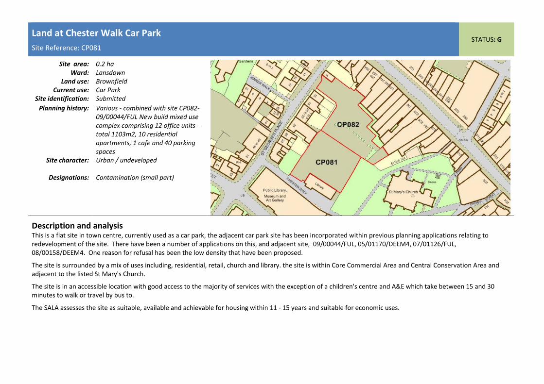
Land at Chester Walk Car Park
Site Reference: CP081 STATUS: G
Site area: 0.2 ha
Ward: Lansdown Land use: Brownfield
Current use: Car Park Site identification: Submitted
Planning history: Various - combined with site CP082- 09/00044/FUL New build mixed use complex comprising 12 office units - total 1103m2, 10 residential apartments, 1 cafe and 40 parking spaces
Site character: Urban / undeveloped
Designations: Contamination (small part)
Description and analysis This is a flat site in town centre, currently used as a car park, the adjacent car park site has been incorporated within previous planning applications relating to redevelopment of the site. There have been a number of applications on this, and adjacent site, 09/00044/FUL, 05/01170/DEEM4, 07/01126/FUL, 08/00158/DEEM4. One reason for refusal has been the low density that have been proposed.
The site is surrounded by a mix of uses including, residential, retail, church and library. the site is within Core Commercial Area and Central Conservation Area and adjacent to the listed St Mary's Church.
The site is in an accessible location with good access to the majority of services with the exception of a children's centre and A&E which take between 15 and 30 minutes to walk or travel by bus to.
The SALA assesses the site as suitable, available and achievable for housing within 11 - 15 years and suitable for economic uses.

Rear of High Street Car Park
Site Reference: CP082 STATUS: R
Site area: 0.2 ha
Ward: Lansdown Land use: Brownfield
Current use: Car Park Site identification: Officer identified
Planning history: Combined with site CP081 - 09/00044/FUL) New build mixed use complex comprising 12 office units - total 1103m2, 10 residential apartments, 1 cafe and 40 parking spaces
Site character: Urban / undeveloped
Designations: Contamination (small part)
Description and analysis Flat site in town centre, currently used as a car park. Site is within Core Commercial Area, Central Conservation Area and partly within Central Shopping Area as defined within the adopted Local Plan. The site is in an accessible location with good access to all services by car and between 5 and 15 by bus or walking.
The SALA assesses the site as suitable for housing and economic uses.

Henrietta Street Car Park, St Margarets Road
Site Reference: CP083 STATUS: R
Site area: 0.4 ha
Ward: St Pauls Land use: Brownfield
Current use: Car Park Site identification: Officer identified
Planning history: N/A Site character: Urban / undeveloped
Designations: Contamination (small part)
Description and analysis Flat site in town centre, currently used as a car park. The site is within Core Commercial Area and Central Conservation Area as defined within the adopted Local Plan, and is also adjacent Central Shopping Area. Part of site has received permission for residential development. The site is in an accessible location with good access to all services by car and between 5 and 20 by bus or walking.
The SALA assesses the site as suitable for housing and economic uses.

47 - 51 Swindon Road
Site Reference: CP084 STATUS: A
Site area: 8.9 ha
Ward: St Pauls Land use: Brownfield
Current use: Car workshop Site identification: Officer identified
Planning history: 15/00354/FUL - demolition of existing buildings and replacement with 10 dwellings - pending consideration
Site character: Urban / developed
Designations: Contamination
Description and analysis This is a flat, brownfield site within the urban and currently in use as a garage/car workshop. A planning application has been submitted (15/00354/FUL) for 10 dwellings and is currently pending consideration.
The site is in an accessible location with good access to the majority of services with the exception of a children's centre and A&E which would take between 15 and 30 munites by bus or walking.
The SALA assesses the site as suitable and available for housing and suitable for economic uses.

Land adjoining Kynance, Church Road
Site Reference: CP085 STATUS: G
Site area: 1.6 ha
Ward: Swindon Village Land use: Greenfield
Current use: Garden Land Site identification: Submitted
Planning history: 11/01868/FUL replacement dwelling on part of site (completed)
Site character: Urban / undeveloped
Designations: Contamination (small part), Conservation Area,
Description and analysis This site comprises, residential property with garden and adjacent farmland site. It is a flat part greenfield, part brownfield site in a predominantly residential area, within the Swindon Village, to the north of the town. The site is in a conservation area.
The site has good access to the majority of facilities by car (under 5 minutes) with it taking between 5 - 15 minutes to access a library, secondary school, children's centre or ACCIDENT AND EMERGENCY / MINOR INJURIES UNIT by car. Access by bus or walking to facilities is varied, with access to a library, primary school, GP, Pharmcy and a Fitness centre being under 15 minutes, access to a post office, supermarket, secondary school and children's centre being 15 - 30 minutes and access to ACCIDENT AND EMERGENCY / MINOR INJURIES UNIT being poor at over 30 minutes.
The SALA assesses the site as suitable, available and achievable for housing (in part) within 6 - 10 years.

Former Monkscroft Primary School
Site Reference: CP086 STATUS: G
Site area: 1.8 ha
Ward: St Marks Land use: Greenfield / Brownfield
Current use: Vacant former school playing field, private
Site identification: Submitted
Planning history: N/A Site character: Urban / undeveloped
Designations:
Description and analysis The site comprises the playing fields of the former Monkscroft Primary school, between the Shakespeare Road to the north and Shelly Road to the south. The main school buildings have been demolished and replaced with a residential care home. The local community has expressed interest to safeguard the site as a local green space.
The SALA assesses the site as suitable, available and achievable for housing, within 6 - 10 years, and economic uses.

Land at Stone Crescent
Site Reference: CP087 STATUS: G
Site area: 0.5 ha
Ward: St Marks Land use: Greenfield
Current use: Vacant Land / open space Site identification: Submitted
Planning history: 14/01276/OUT - granted subject to s106
Site character: Urban / undeveloped
Designations:
Description and analysis The site comprises a roughly rectangular piece of land, 0.55 hectares, to the north of the King George V playing field in St. Marks. The site is fenced off from the playing field and does not form part of the designated Public Green Space. The surrounding area to the north is largely residential - the land to the north-east (through which the proposed development site would be accessed) having been developed for housing in the early 2000s. Rowanfield Primary and Junior Schools are located adjacent to the eastern site boundary. Outline planning permission has been granted for 20 new houses (including affordable) and access to the site would be provided from Stone Crescent. GCC intended to put the site up for sale week commencing 12th January with consent, including AH provision.
The SALA assesses the site as suitable, available and achievable for housing within 6 -10 years.

Pittville School, New Barn Lane
Site Reference: CP088 STATUS: G
Site area: 1.7 ha
Ward: Prestbury Land use: Greenfield
Current use: School Playing Field Site identification: Submitted
Planning history: N/A Site character: Urban / undeveloped
Designations:
Description and analysis The site is urban greenfield site providing sports playing fields to Pittville school. Development of the site would need to justify the loss of pitches on the site. Access would most likely be gained via Cakebridge Road, a residential area, and is considered more suitable for residential and community uses. The site is being promoted and development could facilitate improvements to school facilities and possible community uses.
The SALA assesses the site as suitable, available and achievable for housing within 11 - 15 years.

Pittville Campus
Site Reference: CP089 STATUS: G
Site area: 2.98 ha
Ward: Prestbury and Pittville Land use: Brownfield
Current use: Education Site identification: Submitted
Planning history: 14/01928/FUL - Student village, including 603 student bedrooms and refurbished media centre and associated uses (gross) - Deferred
Site character: Urban /developed
Designations: None
Description and analysis Pittville Campus is located approximately one mile to the north east of the town centre within a predominantly residential area. The site has been used for educational purposes since the 1960s and up until 2011, when all teaching ceased at the Pittville Campus. The site has two principal street frontages facing Albert Road and New Barn Lane with the playing fields and school grounds of Pittville School forming the south and east boundaries. The surrounding area is predominantly residential and domestic in nature and scale with the exception of several blocks of three and four storey apartments on Albert Road. The Central Conservation Area (Pittville Character Appraisal Area) runs along the southern boundary of the site and the grade 1 listed Pittville Pump Rooms is located within metres of the site. The neighbouring Pittville School is also included in the Index of Buildings of Local Importance.
A recent application (14/01928/FUL) proposes the erection of a student village incorporating 603 new-build student bedrooms, the refurbishment of the existing media centre and the provision of a mixed use games area. In addition, the proposal involves the demolition of existing teaching facilities, 23 existing rooms and the retention and refurbishment of 191 existing student rooms. The Officer's report recommended refusal however the planning committee chose to defer their decision. The national planning practice guidance supports the Council to allow this type of development to contribute towards Cheltenham's housing supply, based on the amount of accommodation it releases in the housing market. Further information and justification is required to establish the number of houses this is likely
to release back to the housing market.
It could therefore be argued that the proposed development of 580 net student bedrooms could go towards meeting the Council’s 5 year housing land supply (although not subject to an affordable housing requirement). However, students tend to live in shared accommodation and therefore the number of dwellings which could be offset would be significantly less than the 580 bedrooms proposed. Further, the proposed development does not specifically relate to the provision of market housing and the applicant has not provided any further information or justification with regards this issue. The SALA assesses the site as suitable, available and achievable for housing, within 5 years, and economic uses.
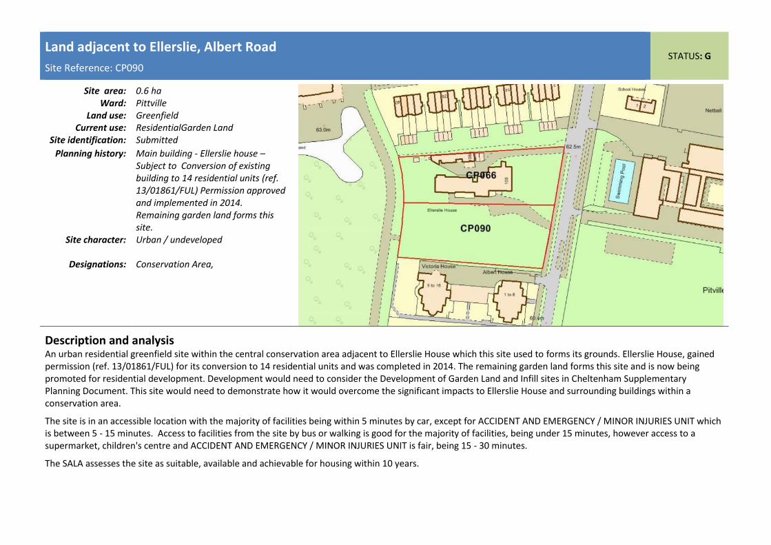
Land adjacent to Ellerslie, Albert Road
Site Reference: CP090 STATUS: G
Site area: 0.6 ha
Ward: Pittville Land use: Greenfield
Current use: ResidentialGarden Land Site identification: Submitted
Planning history: Main building - Ellerslie house –Subject to Conversion of existing building to 14 residential units (ref. 13/01861/FUL) Permission approved and implemented in 2014. Remaining garden land forms this site.
Site character: Urban / undeveloped
Designations: Conservation Area,
Description and analysis An urban residential greenfield site within the central conservation area adjacent to Ellerslie House which this site used to forms its grounds. Ellerslie House, gained permission (ref. 13/01861/FUL) for its conversion to 14 residential units and was completed in 2014. The remaining garden land forms this site and is now being promoted for residential development. Development would need to consider the Development of Garden Land and Infill sites in Cheltenham Supplementary Planning Document. This site would need to demonstrate how it would overcome the significant impacts to Ellerslie House and surrounding buildings within a conservation area.
The site is in an accessible location with the majority of facilities being within 5 minutes by car, except for ACCIDENT AND EMERGENCY / MINOR INJURIES UNIT which is between 5 - 15 minutes. Access to facilities from the site by bus or walking is good for the majority of facilities, being under 15 minutes, however access to a supermarket, children's centre and ACCIDENT AND EMERGENCY / MINOR INJURIES UNIT is fair, being 15 - 30 minutes.
The SALA assesses the site as suitable, available and achievable for housing within 10 years.

Hardwick Site, St. Pauls Road
Site Reference: CP091 STATUS: R
Site area: 1.9 ha
Ward: St Paul's Land use: Brownfield
Current use: University/Education/Sports pitches - part buit/part buildings
Site identification: CSA 2007
Planning history: N/A Site character: Urban / developed
Designations:
Description and analysis A flat brownfield site containing University buildings and sports pitches within th principal urban area. The site has also been submitted for consideration as a Local Green Space site.
The site is in an accessible location with the majority of facilities being within 5 minutes by car. Access to facilities from the site by bus or walking is good for the majority of facilities, being under 15 minutes, however access to Accident and Emergency and/or an Minor Injuries unit is fair; taking approximately 15 - 30 minutes to travel using public transport.
This site has not been assessed by the SALA.
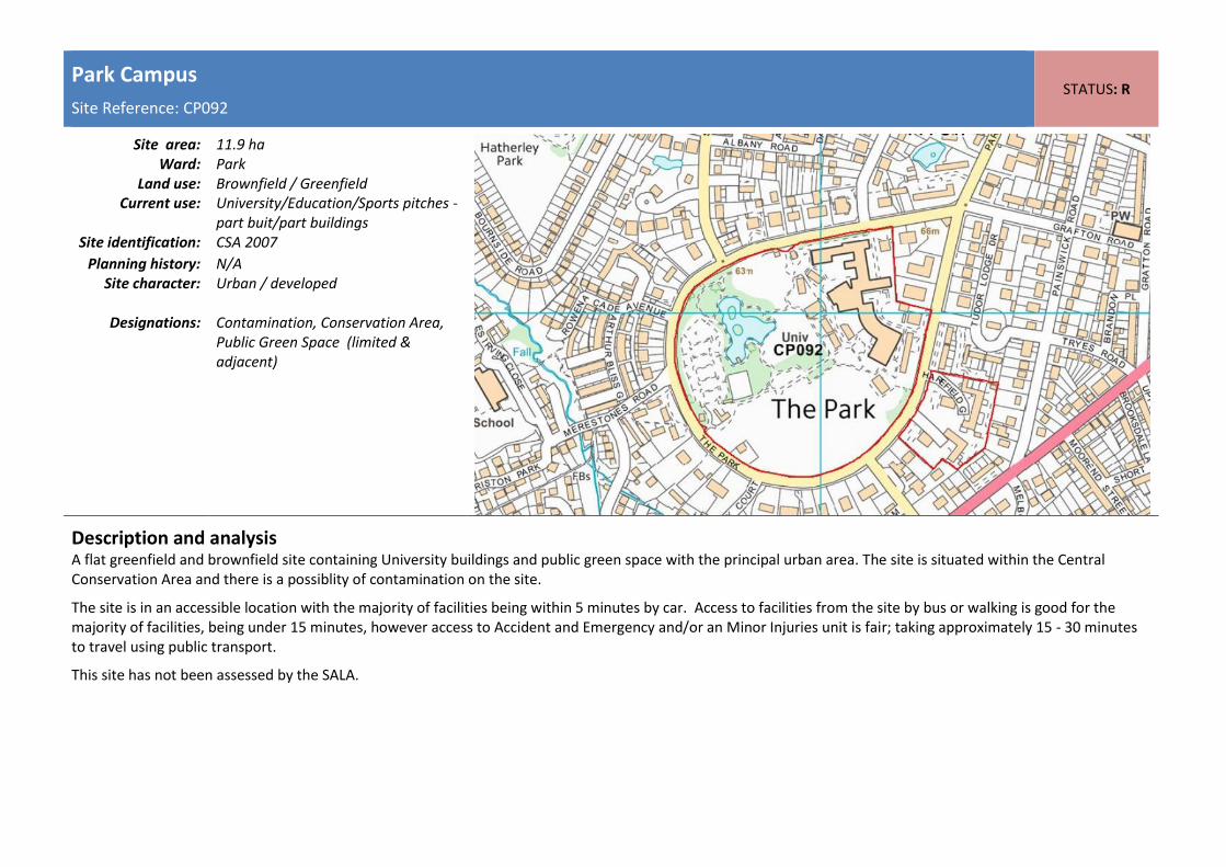
Park Campus
Site Reference: CP092 STATUS: R
Site area: 11.9 ha
Ward: Park Land use: Brownfield / Greenfield
Current use: University/Education/Sports pitches - part buit/part buildings
Site identification: CSA 2007
Planning history: N/A Site character: Urban / developed
Designations: Contamination, Conservation Area,
Public Green Space (limited & adjacent)
Description and analysis A flat greenfield and brownfield site containing University buildings and public green space with the principal urban area. The site is situated within the Central Conservation Area and there is a possiblity of contamination on the site.
The site is in an accessible location with the majority of facilities being within 5 minutes by car. Access to facilities from the site by bus or walking is good for the majority of facilities, being under 15 minutes, however access to Accident and Emergency and/or an Minor Injuries unit is fair; taking approximately 15 - 30 minutes to travel using public transport.
This site has not been assessed by the SALA.

Depot
Site Reference: CP093 STATUS: R
Site area: 3.8 ha
Ward: Swindon Village Land use: Brownfield
Current use: Waste site Site identification: CSA 2007
Planning history: N/A Site character: Urban / developed
Designations: Landfill, Contamination
Description and analysis A flat brownfield site with the principal urban area. The existing use is a waste depot and as such the land is likely to be contaminated. The site is situated on the eastern edge of the Kingsditch trading estate and bordered to the east by the main railway line running through Cheltenham.
The site is in an accessible location with the majority of facilities being within 5 minutes by car. Access to facilities from the site by bus or walking is good for the majority of facilities, being under 15 minutes, however access to Accident and Emergency and/or an Minor Injuries unit is fair; taking approximately 15 - 30 minutes to travel using public transport.
This site has not been assessed by the SALA.

Sandford Lido Car Park
Site Reference: CP094 STATUS: R
Site area: 0.3 ha
Ward: College Land use: Brownfield
Current use: Car Park Site identification: CSA 2007
Planning history: N/A Site character: Urban / developed
Designations: Conservation Area, Flood Zone 2,
Flood Zone 3
Description and analysis This is a flat car park site within the Central Conservation area in urban area of Cheltenham. To the north is Sandford Lido, the east Sandford Park, the south the Fire Station and to the west Cheltenham Hospital. The car park is entirely within Flood Zones 2 & 3.
The site is in an accessible location with good access to all facilities by car (under 5 minutes) and by bus or walking (under 15 minutes) with the exception of access to a secondary school, which takes 15 - 30 minutes by bus or walking.
The SALA assesses the site as not suitable, available or achievable for housing or economic uses.

St James's Street Car Park
Site Reference: CP095 STATUS: R
Site area: 0.5 ha
Ward: All Saints Land use: Brownfield
Current use: Car Park Site identification: CSA 2007
Planning history: N/A Site character: Urban / developed
Designations: Conservation Area
Description and analysis This is a flat, car park site within the core commercial area and central conservation area. It is surrounded by a mix of commercial and residential properties and a primary school.
The site is in an accessible location with good access to all facilities by car (under 5 minutes) and good access to all facilities by bus or walking (under 15 minutes) with the exception of access to a children's centre which takes longer at 15 - 30 minutes by bus or walking.
The SALA asssesses the site as suitable for housing and economic uses.

St. George's Road Car Park
Site Reference: CP096 STATUS: R
Site area: 0.3 ha
Ward: Lansdown Land use: Brownfield
Current use: Car Park Site identification: CSA 2007
Planning history: N/A Site character: Urban / developed
Designations: Conservation Area
Description and analysis This is a gently sloping car park site within the core commercial area and central conservation area. It is surrounded by a mix of commercial and residential uses.
The site is in an accessible location being under 15 minutes of all major services by foot and bus.
The SALA assesses the site as suitable for housing and economic uses.

Bath Terrace Car Park
Site Reference: CP097 STATUS: R
Site area: 0.4 ha
Ward: Park Land use: Brownfield
Current use: Car Park Site identification: CSA 2007
Planning history: N/A Site character: Urban / developed
Designations: Conservation Area
Description and analysis This is a flat, car park site within the urban area and central conservation area, which supports the Bath Road District centre. It is surrounded by a mix of commerical and residential properties and has public toilets on site.
The site is in an accessible location with good access to all facilities by car (under 5 minutes) and by bus/walking (under 15 minutes) with the exception of access to a secondary school by bus or walking which is longer at 15 - 30 minutes.
The SALA assesses the site as suitable for housing or economic uses.

Land south of Collum End Rise
Site Reference: CP098 STATUS: R
Site area: 3.3 ha
Ward: Leckhampton Land use: Greenfield
Current use: Open land Site identification: CSA 2007
Planning history: N/A Site character: Edge of urban / undeveloped
Designations: Green Belt JCS, AONB
Description and analysis This is a greenfield site, outside of the urban area to the south of Cheltenham. It is adjacent to residential development to the north but is within the Green belt and the AONB. The site is adjacent to a residential development site to the east and to the south the AONB slopes steeply up the hill. To the west is a church and open land. There is public access onto the land.
The site has good access by car (under 5 minutes and bus/walking (under 15 minutes) including to a supermarket, primary school, children's centre, GP and fitness facility, with it taking longer by car ( 5 - 15 minutes) and by bus/walking (15 - 30 minutes) including access a library and ACCIDENT AND EMERGENCY / MINOR INJURIES UNIT. Access to ACCIDENT AND EMERGENCY / MINOR INJURIES UNIT by bus or walking is poor at over 30 minutes.
The SALA assesses the site as not suitable, available or achievable for housing or economic uses.

Land at Swindon Lane (Adj to dismanted line)
Site Reference: CP099 STATUS: R
Site area: 1.1 ha
Ward: Prestbury Land use: Greenfield
Current use: Agriculture Site identification: Submitted
Planning history: 00/004781/FUL, 09/01809/FUL, 13/00020/TIME - relating to replacement of 4 bed dwelling. Site incorporated within a previous application covering a wider area - Land at Hunting Butts 09/01589/OUT, not included in subsequent application 11/00257/OUT.
Site character: Edge of urban / undeveloped
Designations: Green Belt JCS
Description and analysis This is a greenfield site, adjacent to residential, however outside of the urban area to the north of Cheltenham and within Green belt. The site makes significant contribution towards green belt purposes (JCS Green Belt Review). The site scores Medium - low in the JCS Lanscape Sensitivity Study.
A number of plaanning permissions (00/004781/FUL, 09/01809/FUL, 13/00020/TIME ) relating to replacement of 4 bed dwelling. The site was also incorporated within a previous application covering a wider area - Land at Hunting Butts (SO10) 09/01589/OUT but not included in the subsequent application 11/00257/OUT.
The site has good access to the majority of service by car being under 5 minutes with the exception of access to a children's centre and ACCIDENT AND EMERGENCY / MINOR INJURIES UNIT which takes longer at 5 - 15 minutes. Access from the site to facilities by bus/walking is fair, taking between 15 - 30 minutes with the exception of A&E which is poor at over 30 minutes.
The SALA assesses the site as available for housing and economic uses

Battledown
Site Reference: CP100 STATUS: R
Site area: 14.7 ha
Ward: Battledown Land use: Greenfield
Current use: Open land Site identification: CSA 2007
Planning history: N/A Site character: Edge of urban / undeveloped
Designations: AONB
Description and analysis This is a sloping, greenfield site within the AONB to the east of Cheltenham, it is adjacent to residential areas to the north, west and south. To the north and partially to the east, the site is bordered by GCHQ Oakley residential redevelopment site.
The site is in an accessible location with good access to all facilities by car, bus and walking, being under 5 and 15 minutes repectively with the exception of access to a secondary school by bus or walking which takes longer at between 15 - 30 minutes.
The SALA assesses the site as not being suitable, available or achievable for housing or economic uses.

North Place and Portland Street
Site Reference: CP101 STATUS: G
Site area: 2 ha
Ward: St Paul's and Pittville Land use: Brownfield
Current use: Car Park Site identification: CBC
Planning history: 12/01612/FUL: Erection of a mixed use development comprising; 5,792sqm (gross external floor space) of class A1 food store, 739sqm (gross) of class A1 shops and 19sqm (gross) of class A2 within atrium space and 336sqm (gros
Site character: urban / developed
Designations: Existing Local Plan Allocation, Conservation Area
Description and analysis North Place and Portland Street area was formerly used as the main Coach and Bus station in Cheltenham. The site currently provides 813 parking spaces. The site lends itself to a mixed use scheme; the key drivers are the scale of each use, how they relate to the site context and how they stack up commercially. It will be important to make sure the site is not be seen in isolation of other town centre schemes such as Boots Corner, the Brewery link and obtaining rights over the parking area of St Margaret's Terrace which could all could provide cumulative benefits.
The site is located within the central conservation area of Cheltenham and is approximately 2 hectares in area (3.2 including the highway). The site sits within the Central Conservation Area, and is immediately adjacent to the grade II* Trinity Church; the grade II* Saint Margaret's Terrace; and the grade II Dowty House, and consequently the form, massing and design of the any development has potential to impact upon the adjacent historic environment, either positively or negatively. English Heritage states that the potential for the new development provides a rare opportunity that should be grasped.
Since planning permission was granted Morrisons supermarket has withdrawn from the site leaving the proposal less certain. Whilst this site remains a planning commitment until the application expires in 2017 the Cheltenham Plan should actively promote the reuse of a town centre brownfield site. The site is in an accessible location, with good access to all facilities by car (under 5 minutes) and by bus or walking (under 15 minutes).
The SALA assesses the site as suitable, available and achievable for housing, within 6 - 15 years, and economic uses.

Spirax Sarco HQ, Charlton House
Site Reference: CP102 STATUS: R
Site area: 1.9 ha
Ward: Charlton Park Land use: Brownfield
Current use: Employment Site identification: Submitted
Planning history: Various applications relating to existing HQ, including 13/0112/FUL
Site character: urban /developed
Designations: Flood Zone 2, Flood Zone 3
Description and analysis Site was included along with all Spirax Sarco sites when they were looking to consolidate sites. Sites at St George's Road and Tennyson Road were redeveloped to fund the redevelopment and consolidation of uses on the Runnings Road site. It was felt that Charlton House provided a good training/front of house site for Spirax Sarco and site was therefore unlikely to be available for redevelopment. There have been various planning applications relating to existing HQ, including 13/0112/FUL to provide new road bridge crossing the River Chelt, new conference building, new cyclists facilities comprising changing block and cycle store, new roads, footpaths, landscaping and boundary fence. Site is not being promoted.

Whaddon Road
Site Reference: CP105 STATUS: G
Site area: 1.2 ha
Ward: Oakley Land use: Brownfield
Current use: Car park Site identification: Submitted
Planning history: In preparation Site character: Urban
Designations:
Description and analysis The site is a flat, car park site associated wioth Cheltenham Town Football Club. developed, site within the urban area containing pre-fabricated bungalows. The surrounding area is predominantly residential with commercial/employment uses to the west and Cheltenham Town Football Club east. The site is subject to a 'land swap' with theCakebridge Place which will allow for the development of residential development outside of the flood risk area. The redevelopment on land at Whaddon Road would provide a total of 16 houses which would provide a net gain of 7. Redevelopment of the Cakebridge Place site would be as a car park use for the Football Club. See site CP069.
The site has good accessibility to a range of facilities by car (under 5 minutes), bus or walking (under 15 minutes) with the exception of access to ACCIDENT AND EMERGENCY / MINOR INJURIES UNIT by bus or walking which is between 15 - 30 minutes.
The SALA assesses the site as available, suitable and achievable for housing within 0 - 5 years