Embed Size (px)
Citation preview
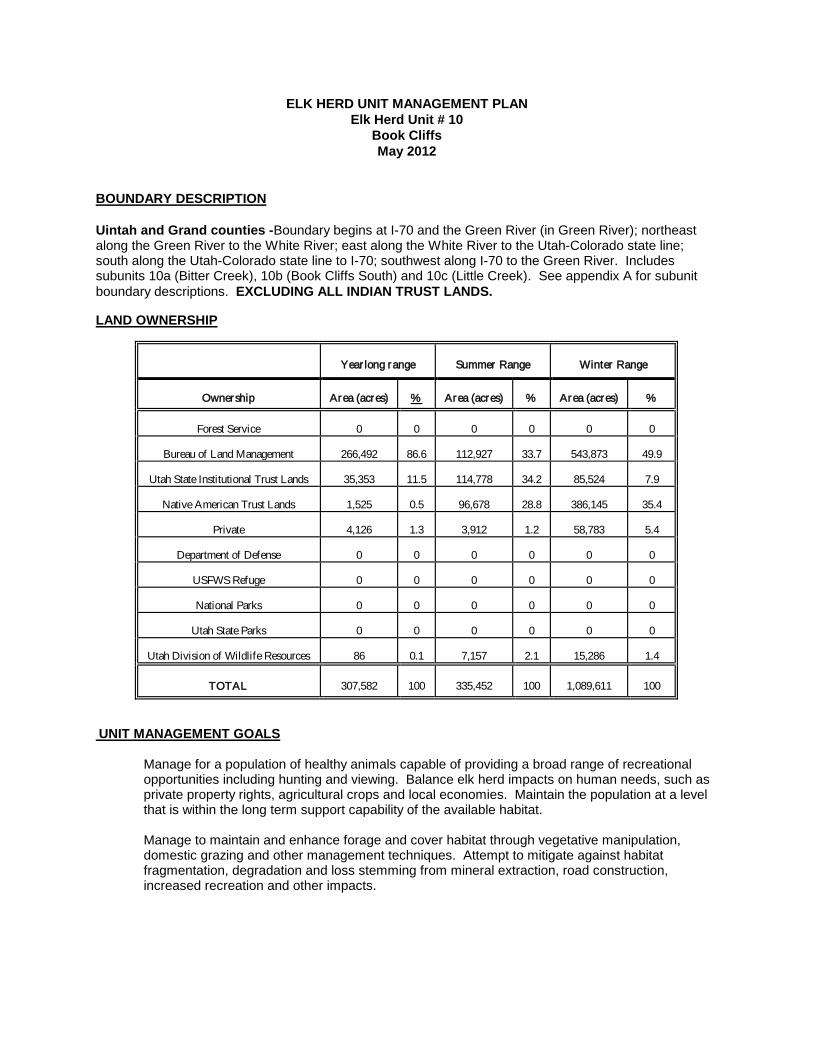
ELK HERD UNIT MANAGEMENT PLAN Elk Herd Unit # 10
Book Cliffs May 2012
BOUNDARY DESCRIPTION Uintah and Grand counties -Boundary begins at I-70 and the Green River (in Green River); northeast along the Green River to the White River; east along the White River to the Utah-Colorado state line; south along the Utah-Colorado state line to I-70; southwest along I-70 to the Green River. Includes subunits 10a (Bitter Creek), 10b (Book Cliffs South) and 10c (Little Creek). See appendix A for subunit boundary descriptions. EXCLUDING ALL INDIAN TRUST LANDS. LAND OWNERSHIP
Year long range
Summer Range
Winter Range
Ownership
Area (acres)
%
Area (acres)
%
Area (acres)
%
Forest Service
0
0
0
0
0
0
Bureau of Land Management
266,492
86.6
112,927
33.7
543,873
49.9
Utah State Institutional Trust Lands
35,353
11.5
114,778
34.2
85,524
7.9
Native American Trust Lands
1,525
0.5
96,678
28.8
386,145
35.4
Private
4,126
1.3
3,912
1.2
58,783
5.4
Department of Defense
0
0
0
0
0
0
USFWS Refuge
0
0
0
0
0
0
National Parks
0
0
0
0
0
0
Utah State Parks
0
0
0
0
0
0
Utah Division of Wildlife Resources
86
0.1
7,157
2.1
15,286
1.4
TOTAL
307,582
100
335,452
100
1,089,611
100
UNIT MANAGEMENT GOALS
Manage for a population of healthy animals capable of providing a broad range of recreational opportunities including hunting and viewing. Balance elk herd impacts on human needs, such as private property rights, agricultural crops and local economies. Maintain the population at a level that is within the long term support capability of the available habitat. Manage to maintain and enhance forage and cover habitat through vegetative manipulation, domestic grazing and other management techniques. Attempt to mitigate against habitat fragmentation, degradation and loss stemming from mineral extraction, road construction, increased recreation and other impacts.
UNIT MANAGEMENT OBJECTIVES
Habitat • Promote sustainable livestock grazing practices that minimize negative impacts to plant
health and diversity, especially on summer ranges and on SITLA and DWR lands where DWR holds the grazing permit or controls livestock grazing.
• Develop new and protect/improve existing water sources for wildlife and livestock to improve distribution and minimize overutilization in proximity to water sources.
• Remove coniferous and juniper tree encroachment into winter range, sagebrush park lands, and summer range aspen forest and mountain browse communities. Approximately 1,500 acres per year will be targeted.
• Open the closed canopy pinion–juniper forest lands at mid elevation zones throughout the Book Cliffs to enhance perennial understory vegetative maintenance. Approximately 1,500 acres per year will be targeted utilizing mechanical and prescribed fire technology.
• Enhance riparian system and canyon bottom vegetative communities through continued agricultural practices, prescriptive grazing and mechanical or chemical treatments. Emphasis on greasewood community improvement will continue.
• Manage to minimize wild horse herds and their impacts. • Explore ways to improve Wyoming sagebrush community condition and perennial
vegetative health. Population
Target Winter Herd Size: Manage toward a herd unit computer model elk winter population size of 7,500. Herd Composition: Utilize limited entry bull permit harvest management for all three subunits. Harvested Bull Age Objectives: Manage for a harvested bull elk 3 year average age of 6.5 – 7.0 years old for the Bitter Creek and South subunits and 7.5 – 8.0 years on the Little Creek Subunit. Antlerless Harvest: Despite being below population objective, some antlerless elk harvest is desirable to address specific range and depredation issues in the Book Cliffs. To address range overutilization issues the Division may continue to issue limited cow elk permits in the San Arroyo and Little Creek areas. To reduce competition with mule deer for crucial winter range, cow hunts may continue in the McCook Ridge area. To reduce damage to private agricultural fields by a low elevation resident elk herd in the lower Willow Creek area the Division may continue to issue cow elk mitigation permits and public draw antlerless permits for that area. Other antlerless elk permits may be recommended if there is justification and need based on range conditions, competition with mule deer, and/or conflicts with agriculture.
CURRENT STATUS OF ELK MANAGEMENT
Habitat Habitat Conditions: Summer range is limited. Drought impacts that include sagebrush mortality, reduced browse vigor and forage production are evident throughout lower elevation ranges. Perennial grasses persist, but annual grass and weed growth have responded to moisture timing and availability. There are 33 permanent range trend study sites on the Book Cliffs (9 sites on the South Book Cliffs subunit and 24 on the Bitter Creek and Little Creek subunits). While these study sites monitor mule deer range conditions and principally target wintering areas, they reflect the impact of drought conditions on the vegetative communities. Few elk winter in areas sampled by the South Book Cliffs range trend studies. In 2010, study sites indicated that soil and browse trends appeared stable. However, species composition of the
herbaceous understory is declining in quality, as composition is primarily annual grasses. Species such as cheatgrass (Bromus tectorum) are increasing in frequency and cover. The North Book Cliffs subunit study sites showed stable and improving soils. Herbaceous plant understories are generally in poor to very poor condition with unsatisfactory species composition. This is due primarily to cheatgrass and annual forb dominance. Browse plant condition and frequency trends are generally improving with problems of declining 4-wing saltbush evident. Distribution of all ungulate herbivory (including elk) on the limited summer range is becoming a more pressing issue. Competition for forage, and especially water between elk, cattle, deer, bison, and an ever growing wild horse herd is increasing and cause for concern among the DWR, BLM, SITLA, and livestock permitees. Recent concerns about overutilization of aspen communities prompted the initiation of an Aspen Study to be conducted by Utah State University. BLM rangeland and forestry specialists specifically expressed concern about the level of elk utilization in aspen stands. When looking at elk population objectives , the Division has taken into account barriers which include, 1) depredation issues 2) winter range that is beyond division control 3) social and political factors 4) current range improvements 5) future range improvements and 6)overall range health. As these factors change the Division will adjust the population objective as needed.
Several factors impact the ability of this unit to support larger elk populations. Drought vegetative impacts of the past decade have interfered with elk numbers. Antlerless elk harvest was initiated to stop, and then slow, elk herd growth and provide relief to vegetative communities. Mineral extraction and associated activities fragment elk habitat and elk security. Pinion and juniper invasion is reducing more beneficial forage production and threatening open and mosaic habitat values. Canopy cover is closing in mid elevation mature pinion and juniper communities. This limits and slowly removes valuable perennial understory species. Limited livestock forage competition has occurred during the drought. Agricultural depredations are generally minimal but do occur.
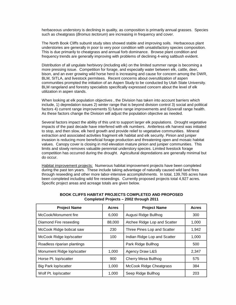
Habitat improvement projects: Numerous habitat improvement projects have been completed during the past ten years. These include taking advantage of naturally caused wild land fires through reseeding and other more labor-intensive accomplishments. In total, 139,765 acres have been completed including wild fire reseedings. Currently proposed projects total 4,927 acres. Specific project areas and acreage totals are given below.
BOOK CLIFFS HABITAT PROJECTS COMPLETED AND PROPOSED Completed Projects – 2002 through 2011
Project Name Acres Project Name Acres
McCook/Monument fire 6,000 Augusi Ridge Bullhog 300
Diamond Fire reseeding 88,000 Atchee Ridge Lop and Scatter 1,000
McCook Ridge bobcat saw 230 Three Pines Lop and Scatter 1,942
McCook Ridge lop/scatter 100 Indian Ridge Lop and Scatter 1,000
Roadless riparian plantings Park Ridge Bullhog 500
Monument Ridge lop/scatter 1,000 Agency Draw L&S 2,347
Horse Pt. lop/scatter 900 Cherry Mesa Bullhog 575
Big Park lop/scatter 1,000 McCook Ridge Cheatgrass 384
Wolf Pt. lop/scatter 1,000 Seep Ridge Bullhog 203
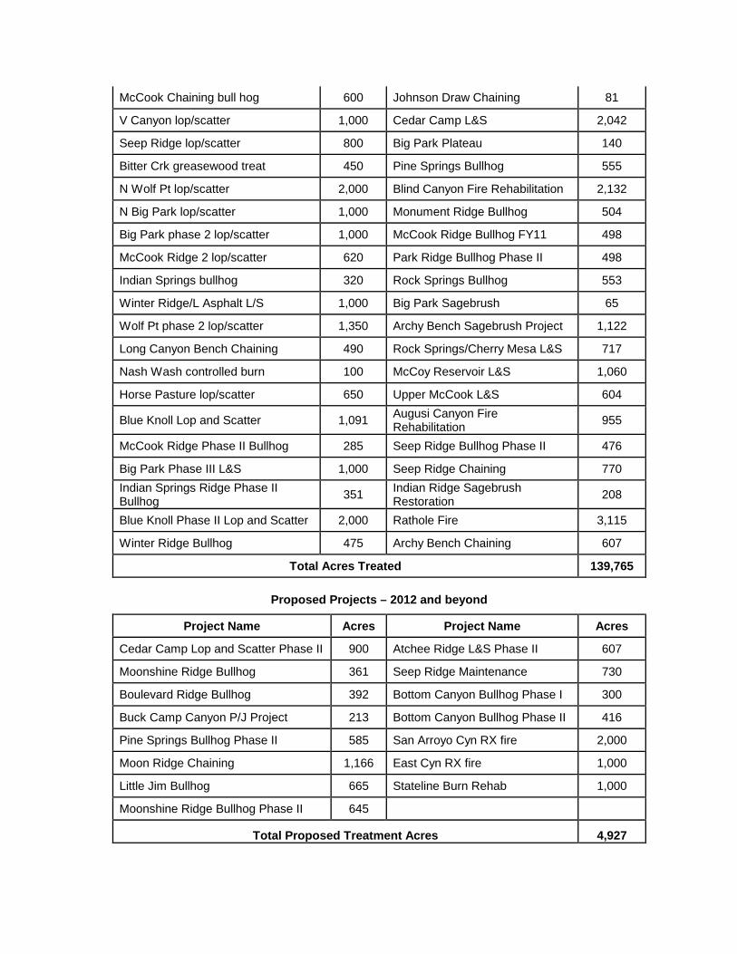
McCook Chaining bull hog 600 Johnson Draw Chaining 81
V Canyon lop/scatter 1,000 Cedar Camp L&S 2,042
Seep Ridge lop/scatter 800 Big Park Plateau 140
Bitter Crk greasewood treat 450 Pine Springs Bullhog 555
N Wolf Pt lop/scatter 2,000 Blind Canyon Fire Rehabilitation 2,132
N Big Park lop/scatter 1,000 Monument Ridge Bullhog 504
Big Park phase 2 lop/scatter 1,000 McCook Ridge Bullhog FY11 498
McCook Ridge 2 lop/scatter 620 Park Ridge Bullhog Phase II 498
Indian Springs bullhog 320 Rock Springs Bullhog 553
Winter Ridge/L Asphalt L/S 1,000 Big Park Sagebrush 65
Wolf Pt phase 2 lop/scatter 1,350 Archy Bench Sagebrush Project 1,122
Long Canyon Bench Chaining 490 Rock Springs/Cherry Mesa L&S 717
Nash Wash controlled burn 100 McCoy Reservoir L&S 1,060
Horse Pasture lop/scatter 650 Upper McCook L&S 604
Blue Knoll Lop and Scatter 1,091 Augusi Canyon Fire Rehabilitation 955
McCook Ridge Phase II Bullhog 285 Seep Ridge Bullhog Phase II 476
Big Park Phase III L&S 1,000 Seep Ridge Chaining 770 Indian Springs Ridge Phase II Bullhog 351 Indian Ridge Sagebrush
Restoration 208
Blue Knoll Phase II Lop and Scatter 2,000 Rathole Fire 3,115
Winter Ridge Bullhog 475 Archy Bench Chaining 607
Total Acres Treated 139,765
Proposed Projects – 2012 and beyond
Project Name Acres Project Name Acres
Cedar Camp Lop and Scatter Phase II 900 Atchee Ridge L&S Phase II 607
Moonshine Ridge Bullhog 361 Seep Ridge Maintenance 730
Boulevard Ridge Bullhog 392 Bottom Canyon Bullhog Phase I 300
Buck Camp Canyon P/J Project 213 Bottom Canyon Bullhog Phase II 416
Pine Springs Bullhog Phase II 585 San Arroyo Cyn RX fire 2,000
Moon Ridge Chaining 1,166 East Cyn RX fire 1,000
Little Jim Bullhog 665 Stateline Burn Rehab 1,000
Moonshine Ridge Bullhog Phase II 645
Total Proposed Treatment Acres 4,927
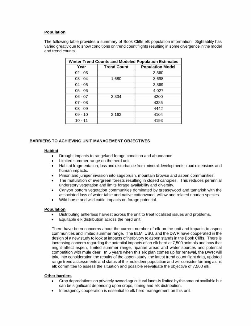
Population
The following table provides a summary of Book Cliffs elk population information. Sightablity has varied greatly due to snow conditions on trend count flights resulting in some divergence in the model and trend counts.
Winter Trend Counts and Modeled Population Estimates Year Trend Count Population Model
02 - 03 3,560 03 - 04 1,680 3,698 04 - 05 3,869 05 - 06 4,027 06 - 07 3,334 4200 07 - 08 4385 08 - 09 4442 09 - 10 2,162 4104 10 - 11 4193
BARRIERS TO ACHIEVING UNIT MANAGEMENT OBJECTIVES Habitat
• Drought impacts to rangeland forage condition and abundance. • Limited summer range on the herd unit. • Habitat fragmentation, loss and disturbance from mineral developments, road extensions and
human impacts. • Pinion and juniper invasion into sagebrush, mountain browse and aspen communities. • The maturation of evergreen forests resulting in closed canopies. This reduces perennial
understory vegetation and limits forage availability and diversity. • Canyon bottom vegetation communities dominated by greasewood and tamarisk with the
associated loss of water table and native cottonwood, willow and related riparian species. • Wild horse and wild cattle impacts on forage potential.
Population
• Distributing antlerless harvest across the unit to treat localized issues and problems. • Equitable elk distribution across the herd unit. There have been concerns about the current number of elk on the unit and impacts to aspen communities and limited summer range. The BLM, USU, and the DWR have cooperated in the design of a new study to look at impacts of herbivory to aspen stands in the Book Cliffs. There is increasing concern regarding the potential impacts of an elk herd at 7,500 animals and how that might affect aspen, limited summer range, riparian areas and water sources and potential competition with mule deer. In 5 years when this elk plan comes up for renewal, the DWR will take into consideration the results of the aspen study, the latest trend count flight data, updated range trend assessments and status of the mule deer population and will consider forming a unit elk committee to assess the situation and possible reevaluate the objective of 7,500 elk.
Other barriers
• Crop depredations on privately owned agricultural lands is limited by the amount available but can be significant depending upon crops, timing and elk distribution.
• Interagency cooperation is essential to elk herd management on this unit.
• Calf-to-cow ratios have been lower than normal in recent years. With calving grounds concentrated in such a narrow band of summer habitat, it is possible that predators such as coyotes and especially black bears have become more effective at killing elk calves and could be impacting recruitment.
STRATEGIES FOR REMOVING BARRIERS AND REACHING UNIT MANAGEMENT OBJECTIVES Habitat Monitoring
• Continue to monitor long term rangeland conditions and health through the permanent range trend sites.
• Annually inspect rangeland vegetative community impacts and health through habitat assessment surveys that include ocular field assessments and range rides.
Actions to Remove Habitat Barriers
• Cooperate with land management agencies to establish natural fire policies that will allow wild fires to burn in beneficial and non threatening areas.
• Continue to cooperate with land management agencies to effectively reseed and/or rehabilitate wildfires to benefit elk and other wildlife.
• Continue with the aggressive juniper, pinion and other conifer treatment projects that target areas of invasion into sagebrush, mountain browse and aspen communities.
• Develop projects to improve vegetative diversity and perennial understory health in closed canopy pinion and juniper forests.
• Continue to treat greasewood and tamarisk communities and reestablish native woody vegetative species in riparian habitat types. Concurrent with these efforts, explore ways to bring water tables closer to the ground surface.
• Work with mineral development interests to attempt to mitigate for habitat fragmentation and losses.
• Seek to expand summer range values by extending and improving canyon-type habitats down drainage systems.
• Work with landowners and associated agencies to limit the impacts and control populations of wild cows and wild horses within the Book Cliffs.
Population Monitoring
Population Size: Aerial helicopter surveys are conducted every three years. These flights are cooperatively timed with the Ute Indian Tribe and data shared to better understand elk population distribution and numbers. These flights and a computer population model program are utilized to track and evaluate the elk herd distribution and annual winter population estimates. Inclusive to these efforts, annual herd classification will be conducted as warranted and possible to estimate herd productivity. Bull Age Structure: Harvested bull ages will be monitored annually through cementum annuli lab analysis of hunter-submitted central incisor teeth. Herd composition classification every three years, annual ground classification and computer modeling will be used to monitor bull:cow ratios. Harvest: The primary means of monitoring harvest will be through the statewide uniform harvest survey. Population size will be achieved through utilizing a variety of harvest methods and seasons. Elk distribution inequities across the herd unit may also be treated through selective public antlerless harvest and hunt areas.
Management Actions to Remove Population Barriers Depredation: Antlerless hunts will continue to be the principle means of limiting cropland depredation. Mitigation permits and vouchers are also used. An active landowner’s association receives limited entry bull permits. Interagency Cooperation: The increasing demands for all natural resource use within the Book Cliffs mandate close association and cooperation between all resource management agencies. While good cooperation and communication is established, this effort will be a priority and will include Private Landowners, BLM, SITLA, Ute Indian Tribe, the public and developers. Elk Population and Distribution: The Book Cliffs harbor a relatively young elk herd and the actual optimum population objective will be determined by factors including but not limited to biological carrying capacity. Efforts to encourage elk to more uniformly utilize herd unit resources will include antlerless hunts and habitat improvements to rangeland vegetative communities. Mineral extraction, road development and OHV use will be monitored and mitigation recommendations made when impacts are evident.
APPENDIX A SUBUNIT BOUNDARY DESCRIPTIONS Unit 10a Book Cliffs, Bitter Creek Subunit Grand and Uintah counties—Boundary begins at the Utah-Colorado state line and the White River; south along this state line to the Book Cliffs summit (north-south drainage divide); west along this summit and drainage divide to Ten Mile Knoll and the Steer Ridge road; north and west along the Steer Ridge road (atop the drainage divide) to the Uintah and Ouray Indian Reservation Boundary (NW 1/4 Sec 7, T17 S R 21 E); north along this boundary to the Uintah-Grand county line; west along this county line to the Green River; north along this river to the White River; east along this river to the Utah-Colorado state line. Unit 10b Book Cliffs, South Subunit Grand County—Boundary begins at the Utah-Colorado state line and the summit and drainage divide of the Book Cliffs; west along this summit and drainage divide to Diamond Ridge; southwest along Diamond Ridge and the Book Cliffs summit (north-south drainage divide) to the Uintah and Ouray Indian Reservation boundary (Hells Hole/head of Sego Canyon); west along this boundary to the Green River; south along the Green River to I-70; east along I-70 to the Utah-Colorado state line; north along this state line to the summit and drainage divide of the Book Cliffs.
Unit 10c Book Cliffs, Little Creek (Roadless) Subunit Grand County--Boundary begins at the Steer Ridge road at Ten Mile Knoll and the Book Cliffs summit (north-south drainage divide); southwest along the Book Cliffs summit on Diamond Ridge to the Uintah and Ouray Indian Reservation boundary (Hells Hole/head of Sego Canyon); north on this boundary (west side of West Willow Creek) to the DWR Wildlife Management Area/Ute Tribe Fence at the confluence of East and West Willow Creek; northeast from this confluence cross-country to the Steer Ridge road (NW 1/4 Sec 7, T17 S R 21 E); south and east on the Steer Ridge road (atop the drainage divide) to Ten Mile Knoll and the Book Cliffs summit.
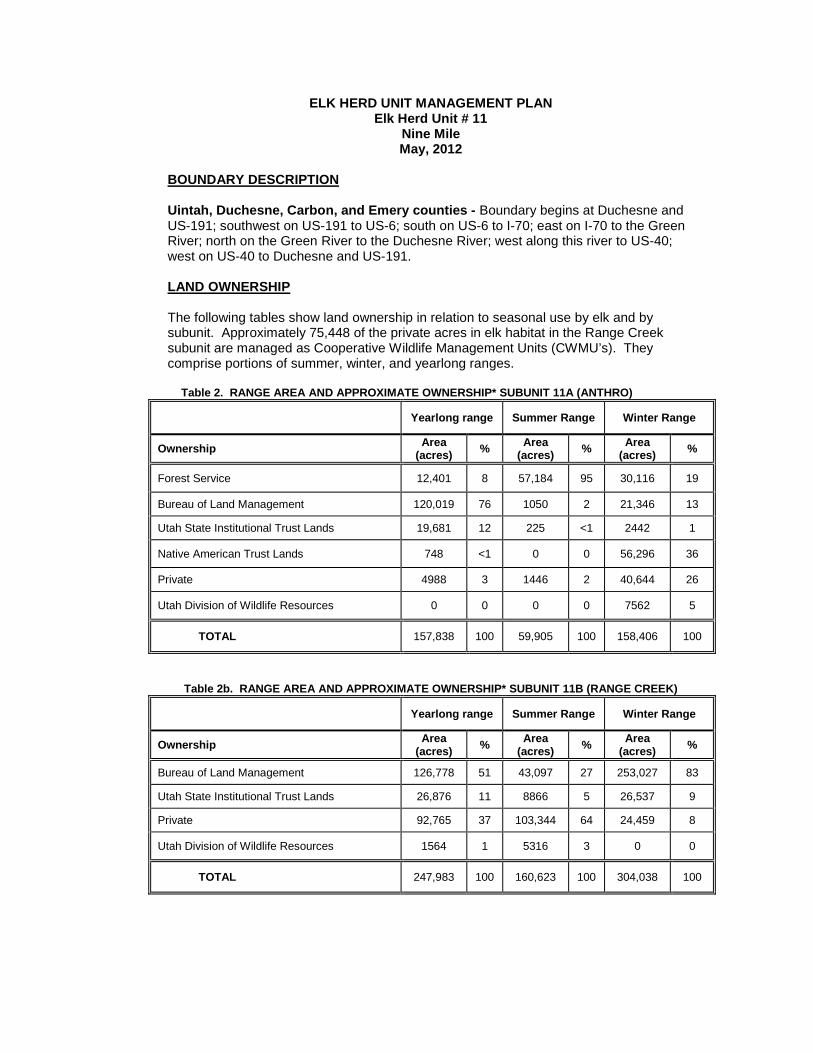
ELK HERD UNIT MANAGEMENT PLAN Elk Herd Unit # 11
Nine Mile May, 2012
BOUNDARY DESCRIPTION
Uintah, Duchesne, Carbon, and Emery counties - Boundary begins at Duchesne and US-191; southwest on US-191 to US-6; south on US-6 to I-70; east on I-70 to the Green River; north on the Green River to the Duchesne River; west along this river to US-40; west on US-40 to Duchesne and US-191. LAND OWNERSHIP The following tables show land ownership in relation to seasonal use by elk and by subunit. Approximately 75,448 of the private acres in elk habitat in the Range Creek subunit are managed as Cooperative Wildlife Management Units (CWMU’s). They comprise portions of summer, winter, and yearlong ranges.
Table 2. RANGE AREA AND APPROXIMATE OWNERSHIP* SUBUNIT 11A (ANTHRO)
Yearlong range Summer Range Winter Range
Ownership Area (acres) % Area
(acres) % Area (acres) %
Forest Service 12,401 8 57,184 95 30,116 19 Bureau of Land Management 120,019 76 1050 2 21,346 13
Utah State Institutional Trust Lands 19,681 12 225 <1 2442 1 Native American Trust Lands 748 <1 0 0 56,296 36 Private 4988 3 1446 2 40,644 26 Utah Division of Wildlife Resources 0 0 0 0 7562 5
TOTAL 157,838 100 59,905 100 158,406 100
Table 2b. RANGE AREA AND APPROXIMATE OWNERSHIP* SUBUNIT 11B (RANGE CREEK)
Yearlong range Summer Range Winter Range
Ownership Area (acres) % Area
(acres) % Area (acres) %
Bureau of Land Management 126,778 51 43,097 27 253,027 83
Utah State Institutional Trust Lands 26,876 11 8866 5 26,537 9 Private 92,765 37 103,344 64 24,459 8 Utah Division of Wildlife Resources 1564 1 5316 3 0 0
TOTAL 247,983 100 160,623 100 304,038 100
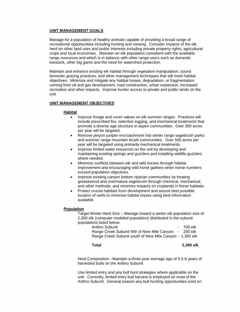
UNIT MANAGEMENT GOALS
Manage for a population of healthy animals capable of providing a broad range of recreational opportunities including hunting and viewing. Consider impacts of the elk herd on other land uses and public interests including private property rights, agricultural crops and local economies. Maintain an elk population consistent with the available range resources and which is in balance with other range users such as domestic livestock, other big game and the need for watershed protection.
Maintain and enhance existing elk habitat through vegetative manipulation, sound domestic grazing practices, and other management techniques that will meet habitat objectives. Minimize and mitigate any habitat losses, degradation, or fragmentation coming from oil and gas development, road construction, urban expansion, increased recreation and other impacts. Improve hunter access to private and public lands on the unit. UNIT MANAGEMENT OBJECTIVES
• Improve forage and cover values on elk summer ranges. Practices will include prescribed fire, selective logging, and mechanical treatments that promote a diverse age structure in aspen communities. Over 300 acres per year will be targeted.
Habitat
• Remove pinyon-juniper encroachment into winter range sagebrush parks and summer range mountain brush communities. Over 500 acres per year will be targeted using primarily mechanical treatments.
• Improve limited water resources on the unit by developing and maintaining existing springs and guzzlers and installing wildlife guzzlers where needed.
• Minimize conflicts between elk and wild horses through habitat improvement and encouraging wild horse gathers when horse numbers exceed population objectives.
• Improve existing canyon bottom riparian communities by treating greasewood and overmature sagebrush through chemical, mechanical, and other methods, and minimize impacts on croplands in these habitats.
• Protect crucial habitats from development and assure best possible location of wells to minimize habitat losses using best information available.
Target Winter Herd Size – Manage toward a winter elk population size of 2,300 elk (computer modeled population) distributed in the subunit populations listed below.
Population
Anthro Subunit - 700 elk Range Creek Subunit NW of Nine Mile Canyon - 250 elk Range Creek Subunit south of Nine Mile Canyon - 1,350 elk Total 2,300 elk
Herd Composition –Maintain a three-year average age of 5.5-6 years of harvested bulls on the Anthro Subunit Use limited entry and any bull hunt strategies where applicable on the unit. Currently, limited entry bull harvest is employed on most of the Anthro Subunit. General season any bull hunting opportunities exist on
the Range Creek Subunit and a small portion of the Anthro Unit near the town of Duchesne to address depredation/public safety concerns (See Appendix A for boundary descriptions). Utilize aggressive antlerless harvest to reduce elk populations as necessary. Promote public hunting access on private lands where applicable.
CURRENT STATUS OF ELK MANAGEMENT
Habitat
Habitat Conditions:
Browse and herbaceous trends appear to be stable over the past 15 years and mid-potential winter ranges where elk typically winter have DCI scores indicating "Fair to Good" winter range.
Summer range is limiting on this unit. Summer elk habitat is restricted to a fairly narrow band of high elevation aspen/Douglas fir communities and elk are found at relatively high densities. Summer ranges and high elevation winter ranges (Mountain big sagebrush communities) appear to be in stable condition according to permanent range trend studies conducted by DWR in 2010. There are a total of 17 permanent range trend study locations that were read in 2010 on the unit. Of these, 8 to 10 sites are within elk winter range.
Cooperative BLM/UDWR spring range transects have shown relatively stable utilization by elk. Pellet group counts and browse utilization has not increased dramatically despite increasing elk populations. BLM range assessments in the area have not noted any deteriorating range conditions or overutilization by elk.
When looking at elk population objectives , the Division has taken into account barriers which include, 1) depredation issues 2) winter range that is beyond division control 3) social and political factors 4) current range improvements 5) future range improvements and 6) overall range health. As these factors change the Division will adjust the population objective as needed. . Several factors impact the ability of this unit to support larger elk populations. Drought is the primary factor that impacts elk populations. Forage production and vigor as well as water distribution is severely limited during drought years. Oil and gas development is becoming a major factor affecting both winter and summer ranges, especially on the Anthro Subunit. Oil and gas development will continue to fragment existing elk habitat and displace elk to less productive areas. Oil and gas activities are also expanding onto summer ranges that are already limiting. Crop depredation by elk on this unit is relatively minor and typically occurs during the spring months. Competition with domestic livestock is a potential conflict on portions of the unit. Many livestock operators are not stocking ranges at full permitted numbers. If operators elect to graze at full numbers, competition would likely be evident due to increased elk numbers that have filled the void of reduced cattle use.
Habitat projects completed and proposed: Federal agencies, private landowners and the UDWR have cooperated on habitat improvement projects targeted at wildlife species that have also benefited elk. Below is a list of completed and future projects.
Table 1. HABITAT PROJECTS COMPLETED AND PROPOSED Completed Projects – 2007 through 2011 Proposed Projects – 2012 and beyond
East Carbon Bullhog, 2007 3400 Cold Springs Prescribed Fire Phase 2 and 3 700
Range Creek Fire Rehab, 2008 93 Cottonwood Ridge PJ Removal 1000
West Coal Creek Bullhog, 2008 1912 Tavaputs Ranch Prescribed Fire 700
Mt. Bartles Harrow and Lop/Scatter, 2009 364 Nutter Ranch Wet Meadow
Project 200
Cold Springs Prescribed Fire, 2010 1054
East Coal Creek Drill Seed, 2010 725
Dugout PJ Removal, 2011 754 Harmon Canyon PJ Removal, 2011 1200
Nutter Ranch Wet Meadow, 2006-2011 300
Nutter’s Ridge Lop and Scatter 1000 Anthro Mountain Prescribed Fire 700
Gilsonite Ride Lop and Scatter 1000
Project total acreage 12,502 acres 2600
acres
Population
Elk populations on both Anthro and Range Creek subunits have increased over the past decade and are above current population objectives. The Anthro Subunit was last surveyed in February of 2009. Aerial surveys and the population model suggest a winter elk population of 1450 elk. The Range Creek Subunit was last surveyed in 2012 when 1320 elk were counted. The estimated 2012 wintering population is 1650 elk. Summer classification counts show an average of 42 calves per 100 cows on both Anthro and Range Creek subunits over the past 5 years. Table 3 shows the trend in bull and antlerless elk harvest on the Nine Mile Unit. Large amounts of antlerless permits are issued on this unit in order to control an expanding elk population. The Anthro and Range Creek South subunits have been managed as Limited Entry Bull units, while the Range Creek North subunit and a portion of the Anthro subunit near Duchesne have been managed as a General Season Any Bull hunt. Furthermore, a significant portion of the harvest on the Range Creek Subunit occurs on CWMU's. General Season Any Bull Hunting will be utilized on all of the Range Creek Subunit beginning in 2012 On the Anthro Subunit, the Ute Tribe has changed their elk hunting strategy to allow general season elk hunting by tribal members. The tribe owns 36% of the winter range on the Anthro Subunit. Although the Anthro Subunit is currently meeting age objectives on harvested bulls, if tribal harvest increases it may be difficult to maintain limited entry age objectives and hunt quality for permit holders in the future. If harvested
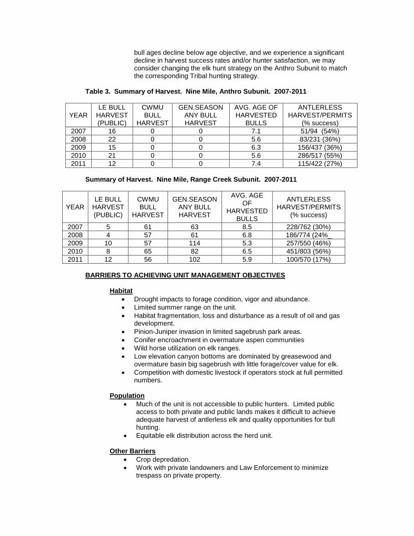
bull ages decline below age objective, and we experience a significant decline in harvest success rates and/or hunter satisfaction, we may consider changing the elk hunt strategy on the Anthro Subunit to match the corresponding Tribal hunting strategy.
Table 3. Summary of Harvest. Nine Mile, Anthro Subunit. 2007-2011
YEAR LE BULL
HARVEST (PUBLIC)
CWMU BULL
HARVEST
GEN.SEASON ANY BULL HARVEST
AVG. AGE OF HARVESTED
BULLS
ANTLERLESS HARVEST/PERMITS
(% success) 2007 16 0 0 7.1 51/94 (54%) 2008 22 0 0 5.6 83/231 (36%) 2009 15 0 0 6.3 156/437 (36%) 2010 21 0 0 5.6 286/517 (55%) 2011 12 0 0 7.4 115/422 (27%)
Summary of Harvest. Nine Mile, Range Creek Subunit. 2007-2011
YEAR LE BULL
HARVEST (PUBLIC)
CWMU BULL
HARVEST
GEN.SEASON ANY BULL HARVEST
AVG. AGE OF
HARVESTED BULLS
ANTLERLESS HARVEST/PERMITS
(% success)
2007 5 61 63 8.5 228/762 (30%) 2008 4 57 61 6.8 186/774 (24%_ 2009 10 57 114 5.3 257/550 (46%) 2010 8 65 82 6.5 451/803 (56%) 2011 12 56 102 5.9 100/570 (17%)
BARRIERS TO ACHIEVING UNIT MANAGEMENT OBJECTIVES
• Drought impacts to forage condition, vigor and abundance. Habitat
• Limited summer range on the unit. • Habitat fragmentation, loss and disturbance as a result of oil and gas
development. • Pinion-Juniper invasion in limited sagebrush park areas. • Conifer encroachment in overmature aspen communities • Wild horse utilization on elk ranges. • Low elevation canyon bottoms are dominated by greasewood and
overmature basin big sagebrush with little forage/cover value for elk. • Competition with domestic livestock if operators stock at full permitted
numbers.
• Much of the unit is not accessible to public hunters. Limited public access to both private and public lands makes it difficult to achieve adequate harvest of antlerless elk and quality opportunities for bull hunting.
Population
• Equitable elk distribution across the herd unit.
• Crop depredation. Other Barriers
• Work with private landowners and Law Enforcement to minimize trespass on private property.
• Other mortality factors – extreme weather conditions such as drought or extreme winter, disease, poaching, and road mortality.
STRATEGIES FOR REMOVING BARRIERS AND REACHING UNIT MANAGEMENT OBJECTIVES
Habitat
Monitoring • Continue to monitor permanent range trend studies throughout
the winter range. • Annually inspect rangeland vegetative community impacts and
health through cooperative DWR/BLM habitat assessment surveys that include ocular field assessments, utilization transects, and range rides.
• Continue to develop and implement Habitat Management Plans for UDWR owned properties on the unit.
Actions to Remove Habitat Barriers
• Cooperate with private landowners, federal and state agencies to allow wildfires to burn in beneficial and nonthreatening areas and to rehabilitate fires in a way that will benefit wildlife.
• Cooperate with private landowners, federal and state agencies to increase vegetative understory and reduce pinion-juniper encroachment in important sagebrush and mountain shrub communities.
• Work with oil and gas interests to protect key areas and minimize, or mitigate for losses due to development.
• Pursue Conservation Easements on critical parcels of private property to protect elk habitat.
• Cooperate with private landowners, oil and gas development companies, federal and state agencies to prepare access management plans to enhance elk habitat value. This may include seasonal road closures or vehicle restrictions.
• Continue to foster good relationships with private landowners and promote habitat enhancement projects that will benefit wildlife on private lands as well as promote public access for hunting opportunities.
Population
Monitoring
Population Size - The population is monitored using harvest data, aerial trend counts and classification, preseason classification, and survival estimates. Bull Age Structure
- Monitor age class structure of the bull population through the use of annual preseason classification, checking stations, uniform harvest surveys, field bag checks, and aerial classification. Average age of harvested bulls from Limited Entry portions of the unit will be determined by tooth age data submitted by each hunter.
Harvest - The primary means of monitoring harvest will be through the statewide uniform harvest survey. The target population size will be

achieved through antlerless harvest using a variety of harvest methods and seasons. Aggressive and localized antlerless harvest will be used to control elk populations and respond to localized range concerns
Management Actions to Remove Population Barriers
Access.
Public access is a major limiting factor on this unit. A larger portion of the total antlerless harvest must come from private lands. Cooperate with private landowners and Tribal lands to assure adequate antlerless harvest will occur on these lands.
Depredation.
Utilize antlerless hunts, landowner mitigation permits, hazing, stackyard fencing and all other means necessary according to DWR guidelines to minimize crop depredation by elk.
Interagency Cooperation. Continue to work closely with federal and state agencies, as well as private landowners and the Ute Tribe. Assure them that proposed population objectives are reasonable and attainable. Respond to any range deterioration concerns.

APPENDIX A. Boundary Description of Subunits used for General Season Bull Hunting Boundaries. Nine Mile, Range Creek . Carbon, Duchesne, and Emery counties. Boundary begins at the junction of the Green River and I-70; north along this river to Nine Mile Creek; west along this creek to the Nine Mile Canyon road near Bulls Canyon; west on this road to the Argyle Canyon Road; northwest on this Road to US-191; southwest on US-191 to US-6; southeast on US-6 to I-70; east on I-70 to the Green River. Portion of Anthro subunit that is open to General Season Any Bull Hunting. Duchesne and Uintah counties. Boundary begins at the Green River and the BLM/ Ute Tribal boundary near Pariette Draw; west along the BLM boundary to the junction with the Pleasant Valley/Antelope Canyon Road (CR-31); west along this road to the Antelope Canyon Road (CR-27); south along this road to the Antelope Canyon/Sowers Canyon Road junction; west along the Sowers Canyon Road (CR-24) to the Indian Canyon/Sowers Canyon Cutoff Road (CR-25); west along this road to US-191; north along US-191 to Duchesne and US-40; east on US-40 to the Duchesne River; east on the Duchesne River to the Green River; south on the Green River to the BLM boundary near Pariette Draw.
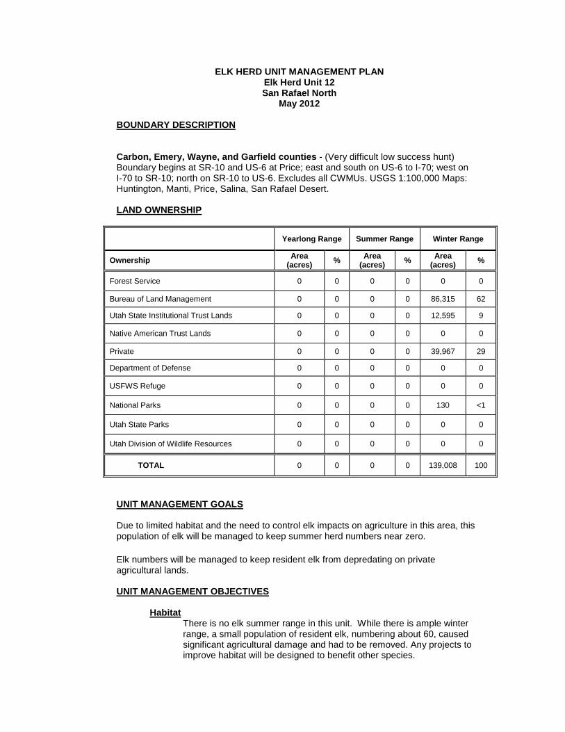
ELK HERD UNIT MANAGEMENT PLAN Elk Herd Unit 12 San Rafael North
May 2012
BOUNDARY DESCRIPTION
Carbon, Emery, Wayne, and Garfield counties - (Very difficult low success hunt)
Boundary begins at SR-10 and US-6 at Price; east and south on US-6 to I-70; west on I-70 to SR-10; north on SR-10 to US-6. Excludes all CWMUs. USGS 1:100,000 Maps: Huntington, Manti, Price, Salina, San Rafael Desert.
LAND OWNERSHIP
Yearlong Range Summer Range Winter Range
Ownership Area (acres) % Area
(acres) % Area (acres) %
Forest Service 0 0 0 0 0 0 Bureau of Land Management 0 0 0 0 86,315 62
Utah State Institutional Trust Lands 0 0 0 0 12,595 9 Native American Trust Lands 0 0 0 0 0 0 Private 0 0 0 0 39,967 29 Department of Defense 0 0 0 0 0 0 USFWS Refuge 0 0 0 0 0 0
National Parks 0 0 0 0 130 <1
Utah State Parks 0 0 0 0 0 0
Utah Division of Wildlife Resources 0 0 0 0 0 0
TOTAL 0 0 0 0 139,008 100 UNIT MANAGEMENT GOALS
Due to limited habitat and the need to control elk impacts on agriculture in this area, this population of elk will be managed to keep summer herd numbers near zero. Elk numbers will be managed to keep resident elk from depredating on private agricultural lands. UNIT MANAGEMENT OBJECTIVES
There is no elk summer range in this unit. While there is ample winter range, a small population of resident elk, numbering about 60, caused significant agricultural damage and had to be removed. Any projects to improve habitat will be designed to benefit other species.
Habitat

Target Summer Herd Size – Near zero in order to minimize depredation problems. However, some wintering elk move from the Central Mountains Manti and Fish Lake units onto this unit each year. This is usually less than 200 animals.
Population
Herd Composition – Age and sex ratios will not be monitored on this unit.
CURRENT STATUS OF ELK MANAGEMENT
Elk habitat in the San Rafael Unit is comprised largely of pinyon-juniper woodlands. A small mountain shrub community exists on Cedar Mountain. Although elk can be found in these habitats year-round, those habitat types are typically winter habitat. Elk in this unit move away from these habitats to irrigated croplands, and they have caused significant losses to farmers and damage to fences.
Habitat
The unit can support 60 summer resident elk, but not without causing agricultural damage. For this reason, the unit is managed to eliminate elk depredation problems. When elk cause damage to irrigated crops or fences, depredation hunts will be held, or mitigation permits will be issued to remove the offending animals. As a result, no projects designed to increase or improve elk habitat have been completed, nor are any planned. Habitat improvement projects in this unit will be designed to benefit other species.
Population
Elk on this unit are not usually surveyed. However, small groups are observed throughout the year that give some indication of population size. About 60 elk reside on Cedar Mountain. These elk move onto agricultural areas near Buffalo Bench in Emery County. In the past there have been a small number of bulls associated with this group. On Molen Reef there have been as many as 30 resident elk, consisting mostly of bulls that lived in pinyon-juniper woodlands east of Moore and Emery. Since the construction of the wildlife exclusionary fencing in 2008 few if any resident elk remain on the reef. The fence was installed to reduce or eliminate big game and vehicle collisions
About 600 elk from the Fish Lake Unit winter on the east side of that unit with a small portion of those elk occasionally using the San Rafael desert east of Last Chance. These elk do not cause agricultural problems and are considered part of the Fish Lake herd. Bull:cow and cow:calf ratios are not determined for the San Rafael Unit. It is managed with antlerless and open bull hunting. Mitigation permits are also issued to address depredation problems. The population has been kept at a level that minimizes damage to agricultural fields, but harvesting all the elk to reach the objective of zero has been challenging because of the difficulty hunters have of locating the small number of elk over such a large area.
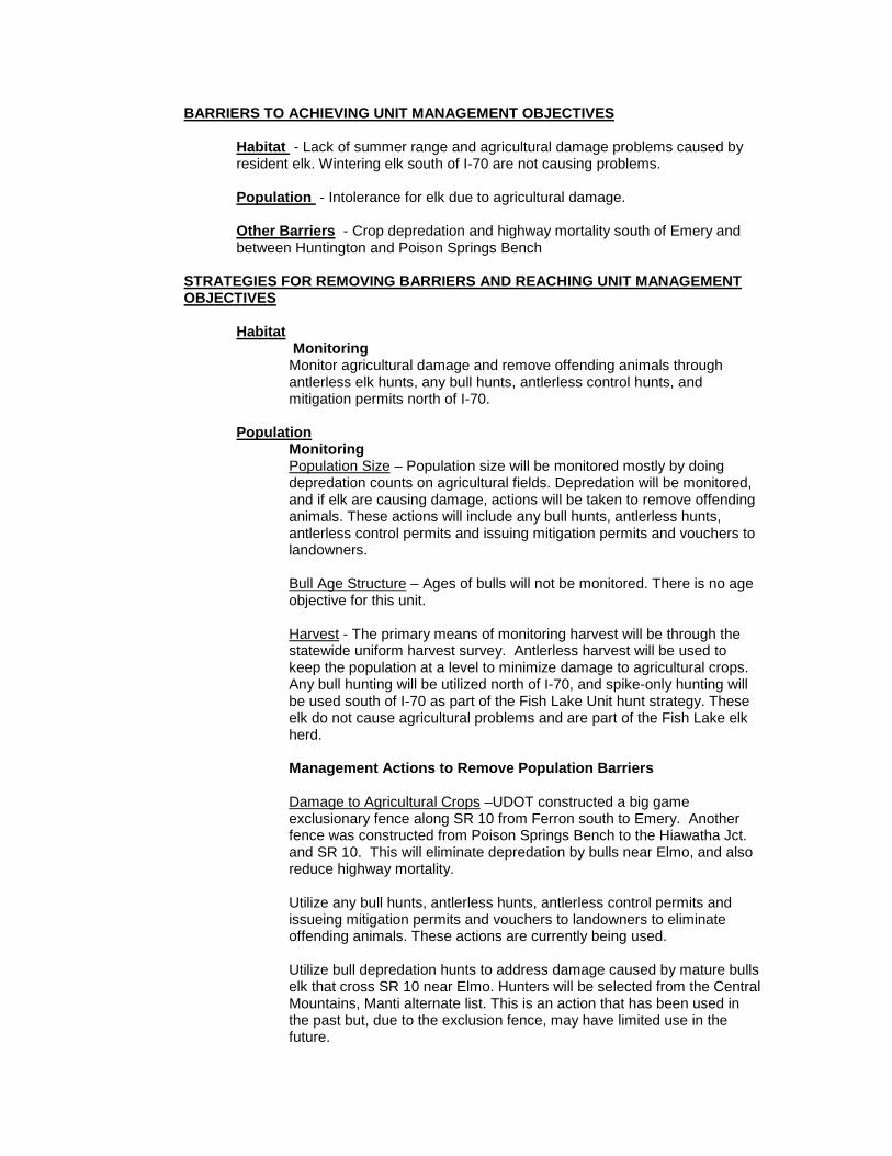
BARRIERS TO ACHIEVING UNIT MANAGEMENT OBJECTIVES
Habitat
- Lack of summer range and agricultural damage problems caused by resident elk. Wintering elk south of I-70 are not causing problems.
Population
- Intolerance for elk due to agricultural damage.
Other Barriers
- Crop depredation and highway mortality south of Emery and between Huntington and Poison Springs Bench
STRATEGIES FOR REMOVING BARRIERS AND REACHING UNIT MANAGEMENT OBJECTIVES
Monitoring Habitat
Monitor agricultural damage and remove offending animals through antlerless elk hunts, any bull hunts, antlerless control hunts, and mitigation permits north of I-70.
Monitoring Population
Population Size
– Population size will be monitored mostly by doing depredation counts on agricultural fields. Depredation will be monitored, and if elk are causing damage, actions will be taken to remove offending animals. These actions will include any bull hunts, antlerless hunts, antlerless control permits and issuing mitigation permits and vouchers to landowners.
Bull Age Structure
– Ages of bulls will not be monitored. There is no age objective for this unit.
Harvest
- The primary means of monitoring harvest will be through the statewide uniform harvest survey. Antlerless harvest will be used to keep the population at a level to minimize damage to agricultural crops. Any bull hunting will be utilized north of I-70, and spike-only hunting will be used south of I-70 as part of the Fish Lake Unit hunt strategy. These elk do not cause agricultural problems and are part of the Fish Lake elk herd.
Management Actions to Remove Population Barriers
Damage to Agricultural Crops
–UDOT constructed a big game exclusionary fence along SR 10 from Ferron south to Emery. Another fence was constructed from Poison Springs Bench to the Hiawatha Jct. and SR 10. This will eliminate depredation by bulls near Elmo, and also reduce highway mortality.
Utilize any bull hunts, antlerless hunts, antlerless control permits and issueing mitigation permits and vouchers to landowners to eliminate offending animals. These actions are currently being used. Utilize bull depredation hunts to address damage caused by mature bulls elk that cross SR 10 near Elmo. Hunters will be selected from the Central Mountains, Manti alternate list. This is an action that has been used in the past but, due to the exclusion fence, may have limited use in the future.
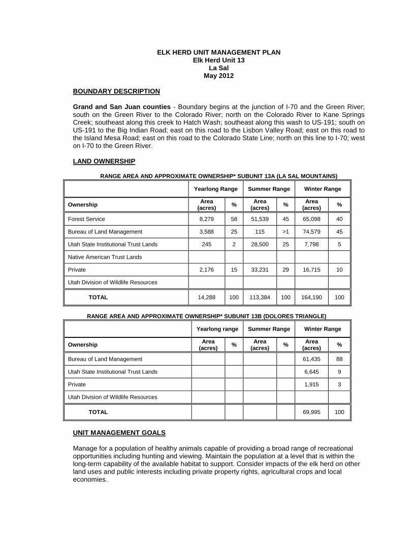
ELK HERD UNIT MANAGEMENT PLAN Elk Herd Unit 13
La Sal May 2012
BOUNDARY DESCRIPTION
Grand and San Juan counties - Boundary begins at the junction of I-70 and the Green River; south on the Green River to the Colorado River; north on the Colorado River to Kane Springs Creek; southeast along this creek to Hatch Wash; southeast along this wash to US-191; south on US-191 to the Big Indian Road; east on this road to the Lisbon Valley Road; east on this road to the Island Mesa Road; east on this road to the Colorado State Line; north on this line to I-70; west on I-70 to the Green River.
LAND OWNERSHIP RANGE AREA AND APPROXIMATE OWNERSHIP* SUBUNIT 13A (LA SAL MOUNTAINS)
Yearlong Range Summer Range Winter Range
Ownership Area (acres) % Area
(acres) % Area (acres) %
Forest Service 8,279 58 51,539 45 65,098 40
Bureau of Land Management 3,588 25 115 >1 74,579 45
Utah State Institutional Trust Lands 245 2 28,500 25 7,798 5
Native American Trust Lands
Private 2,176 15 33,231 29 16,715 10
Utah Division of Wildlife Resources
TOTAL 14,288 100 113,384 100 164,190 100
RANGE AREA AND APPROXIMATE OWNERSHIP* SUBUNIT 13B (DOLORES TRIANGLE)
Yearlong range Summer Range Winter Range
Ownership Area (acres) % Area
(acres) % Area (acres) %
Bureau of Land Management 61,435 88
Utah State Institutional Trust Lands 6,645 9
Private 1,915 3
Utah Division of Wildlife Resources
TOTAL 69,995 100
UNIT MANAGEMENT GOALS
Manage for a population of healthy animals capable of providing a broad range of recreational opportunities including hunting and viewing. Maintain the population at a level that is within the long-term capability of the available habitat to support. Consider impacts of the elk herd on other land uses and public interests including private property rights, agricultural crops and local economies.
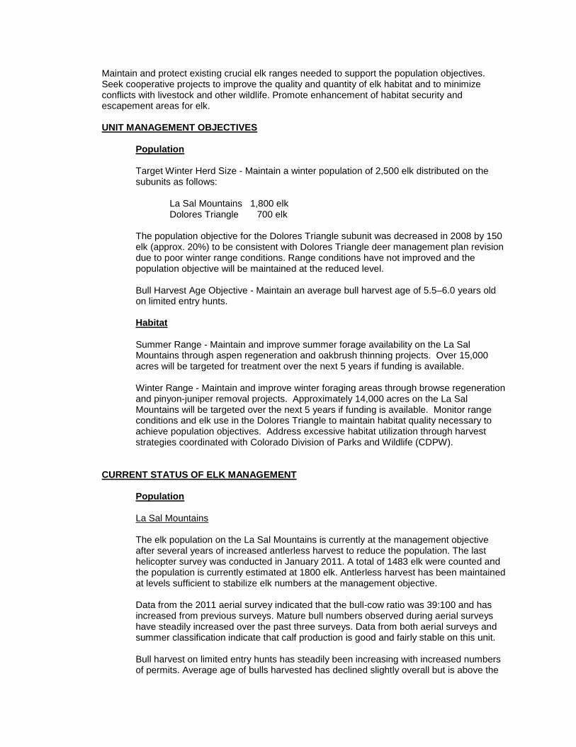
Maintain and protect existing crucial elk ranges needed to support the population objectives. Seek cooperative projects to improve the quality and quantity of elk habitat and to minimize conflicts with livestock and other wildlife. Promote enhancement of habitat security and escapement areas for elk.
UNIT MANAGEMENT OBJECTIVES
Population
Target Winter Herd Size - Maintain a winter population of 2,500 elk distributed on the subunits as follows:
La Sal Mountains 1,800 elk Dolores Triangle 700 elk
The population objective for the Dolores Triangle subunit was decreased in 2008 by 150 elk (approx. 20%) to be consistent with Dolores Triangle deer management plan revision due to poor winter range conditions. Range conditions have not improved and the population objective will be maintained at the reduced level.
Bull Harvest Age Objective - Maintain an average bull harvest age of 5.5–6.0 years old on limited entry hunts.
Habitat
Summer Range - Maintain and improve summer forage availability on the La Sal Mountains through aspen regeneration and oakbrush thinning projects. Over 15,000 acres will be targeted for treatment over the next 5 years if funding is available. Winter Range - Maintain and improve winter foraging areas through browse regeneration and pinyon-juniper removal projects. Approximately 14,000 acres on the La Sal Mountains will be targeted over the next 5 years if funding is available. Monitor range conditions and elk use in the Dolores Triangle to maintain habitat quality necessary to achieve population objectives. Address excessive habitat utilization through harvest strategies coordinated with Colorado Division of Parks and Wildlife (CDPW).
CURRENT STATUS OF ELK MANAGEMENT
Population
La Sal Mountains
The elk population on the La Sal Mountains is currently at the management objective after several years of increased antlerless harvest to reduce the population. The last helicopter survey was conducted in January 2011. A total of 1483 elk were counted and the population is currently estimated at 1800 elk. Antlerless harvest has been maintained at levels sufficient to stabilize elk numbers at the management objective. Data from the 2011 aerial survey indicated that the bull-cow ratio was 39:100 and has increased from previous surveys. Mature bull numbers observed during aerial surveys have steadily increased over the past three surveys. Data from both aerial surveys and summer classification indicate that calf production is good and fairly stable on this unit. Bull harvest on limited entry hunts has steadily been increasing with increased numbers of permits. Average age of bulls harvested has declined slightly overall but is above the
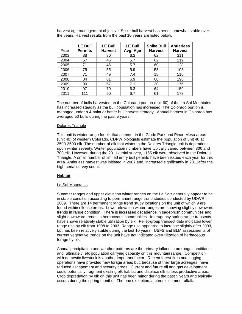
harvest age management objective. Spike bull harvest has been somewhat stable over the years. Harvest results from the past 10 years are listed below.
Year LE Bull Permits
LE Bull Harvest
LE Bull Avg. Age
Spike Bull Harvest
Antlerless Harvest
2003 38 30 6.3 62 311 2004 57 45 5.7 62 219 2005 71 46 5.7 60 128 2006 75 55 5.9 53 108 2007 71 49 7.4 15 115 2008 84 61 6.9 60 198 2009 90 57 7.1 30 176 2010 97 70 6.3 64 159 2011 111 90 6.7 61 178
The number of bulls harvested on the Colorado portion (unit 60) of the La Sal Mountains has increased steadily as the bull population has increased. The Colorado portion is managed under a 4-point or better bull harvest strategy. Annual harvest in Colorado has averaged 50 bulls during the past 5 years.
Dolores Triangle
This unit is winter range for elk that summer in the Glade Park and Pinon Mesa areas (unit 40) of western Colorado. CDPW biologists estimate the population of unit 40 at 2500-3500 elk. The number of elk that winter in the Dolores Triangle unit is dependent upon winter severity. Winter population numbers have typically varied between 300 and 700 elk. However, during the 2011 aerial survey, 1165 elk were observed in the Dolores Triangle. A small number of limited entry bull permits have been issued each year for this area. Antlerless harvest was initiated in 2007 and, increased significantly in 2011after the high aerial survey count.
Habitat
La Sal Mountains
Summer ranges and upper elevation winter ranges on the La Sals generally appear to be in stable condition according to permanent range trend studies conducted by UDWR in 2009. There are 14 permanent range trend study locations on the unit of which 9 are found within elk use areas. Lower elevation winter ranges are showing slightly downward trends in range condition. There is increased decadence in sagebrush communities and slight downward trends in herbaceous communities. Interagency spring range transects have shown relatively stable utilization by elk. Pellet-group transect data indicated lower range use by elk from 1998 to 2003. Range use appeared to increase slightly after 2003, but has been relatively stable during the last 10 years. USFS and BLM assessments of current vegetative trends on the unit have not indicated overutilization of herbaceous forage by elk. Annual precipitation and weather patterns are the primary influence on range conditions and, ultimately, elk population carrying capacity on this mountain range. Competition with domestic livestock is another important factor. Recent forest fires and logging operations have provided new forage areas but, because of their large acreages, have reduced escapement and security areas. Current and future oil and gas development could potentially fragment existing elk habitat and displace elk to less productive areas. Crop depredation by elk on this unit has been minor during the past 5 years and typically occurs during the spring months. The one exception, a chronic summer alfalfa
depredation problem, was resolved by permanently fencing the property. Given the current conditions, associated land use factors, and concern for potential competition with a struggling deer population, the elk population objective cannot be raised at this time Several habitat improvement projects that will benefit elk have been completed or are planned by federal agencies, UDWR, and private landowners. These projects should allow elk numbers to be maintained at the population objective without creating conflicts with other land uses.
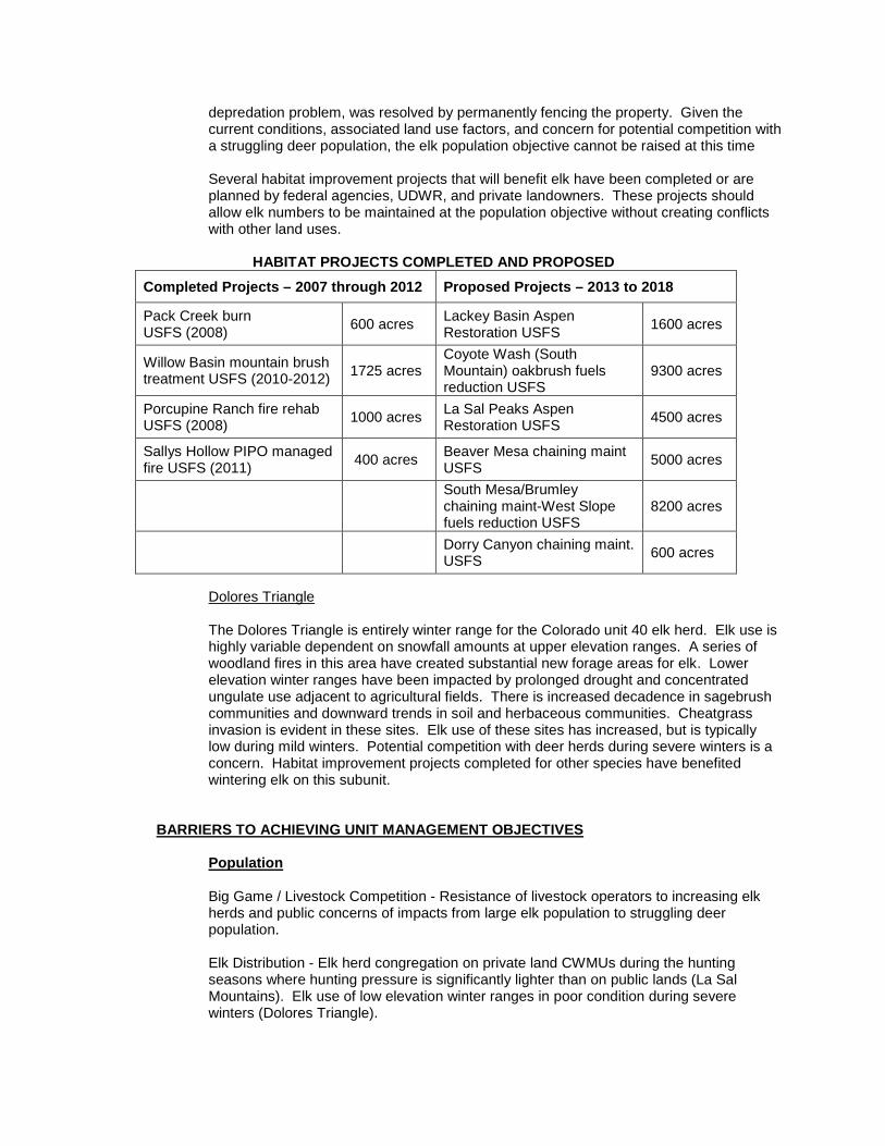
HABITAT PROJECTS COMPLETED AND PROPOSED
Completed Projects – 2007 through 2012 Proposed Projects – 2013 to 2018
Pack Creek burn USFS (2008) 600 acres Lackey Basin Aspen
Restoration USFS 1600 acres
Willow Basin mountain brush treatment USFS (2010-2012) 1725 acres
Coyote Wash (South Mountain) oakbrush fuels reduction USFS
9300 acres
Porcupine Ranch fire rehab USFS (2008) 1000 acres La Sal Peaks Aspen
Restoration USFS 4500 acres
Sallys Hollow PIPO managed fire USFS (2011) 400 acres Beaver Mesa chaining maint
USFS 5000 acres
South Mesa/Brumley chaining maint-West Slope fuels reduction USFS
8200 acres
Dorry Canyon chaining maint. USFS 600 acres
Dolores Triangle
The Dolores Triangle is entirely winter range for the Colorado unit 40 elk herd. Elk use is highly variable dependent on snowfall amounts at upper elevation ranges. A series of woodland fires in this area have created substantial new forage areas for elk. Lower elevation winter ranges have been impacted by prolonged drought and concentrated ungulate use adjacent to agricultural fields. There is increased decadence in sagebrush communities and downward trends in soil and herbaceous communities. Cheatgrass invasion is evident in these sites. Elk use of these sites has increased, but is typically low during mild winters. Potential competition with deer herds during severe winters is a concern. Habitat improvement projects completed for other species have benefited wintering elk on this subunit.
BARRIERS TO ACHIEVING UNIT MANAGEMENT OBJECTIVES
Population
Big Game / Livestock Competition - Resistance of livestock operators to increasing elk herds and public concerns of impacts from large elk population to struggling deer population. Elk Distribution - Elk herd congregation on private land CWMUs during the hunting seasons where hunting pressure is significantly lighter than on public lands (La Sal Mountains). Elk use of low elevation winter ranges in poor condition during severe winters (Dolores Triangle).
Harvest Age Objective - Public resistance to increasing numbers of bull hunting permits to reduce average age of harvest.
Habitat
Drought - Impact of prolonged drought to range condition and forage availability. Limited Summer Range - Amount of quality summer habitat for foraging and reproductive activities is limited and shared with livestock and other big game. Habitat Loss – Plant succession changes in important summer areas (conifer encroachment in aspen stands) and winter areas (pinyon-juniper invasion in mountain brush-sagebrush communities) reduces biological carrying capacity. Lack of browse regeneration and invasion of annual grasses on lower elevation winter ranges also impact habitat quality. Other Barriers
Land Resource Activities - Impacts from habitat fragmentation and disturbance as a result of logging and energy development activities. Elk Distribution on Winter Range - Congregation of large elk herds on some winter areas may result in excessive utilization and could impact range conditions of important deer winter ranges. Crop Depredation - Chronic crop depredation problems could result in reducing elk numbers in specific areas. Predation - The La Sal Mountains has a healthy black bear population. Black bears are known to take elk calves, but bear predation does not appear to have a significant impact on elk calf survival rates. Disease - Chronic wasting disease has been documented in deer and elk on this mountain range.
Illegal Harvest - Extent of illegal harvest on this unit is unknown, but because both subunits cross state boundaries and trophy-quality bulls are present, the potential for illegal activities is elevated. Illegal harvest of mature bulls has the potential to affect the availability of limited entry permits.
STRATEGIES FOR REMOVING BARRIERS AND REACHING UNIT MANAGEMENT OBJECTIVES
Population Monitoring
Population Size - The population is monitored using harvest data, aerial trend counts and classification, preseason classification, and survival estimates. The wintering population on this unit varies because of the movement of elk from and into Colorado depending on winter snowfall amounts.
Bull Age Structure - Monitor age class structure of the bull population through the use of checking stations, uniform harvest surveys, field bag checks, preseason classification and aerial classification.
Harvest - The primary means of monitoring harvest will be through the statewide uniform harvest survey. The target population size will be achieved through antlerless harvest using a variety of harvest methods and seasons.
Management Actions to Remove Population Barriers
Big Game/Livestock Competition - Continue to work with land management agencies and public grazing operators, as well as private landowners to assure that proposed population objectives are reasonable and attainable. Antlerless harvest will be the primary strategy utilized to achieve and maintain population objectives and to address specific habitat concerns and depredation problems. Keep public informed of deer and elk population trends and incorporate elk management strategies that have minimal impacts to the deer population. Elk Distribution - Coordinate with CWMU operators to develop hunting strategies to reduce elk congregations on private land during public land hunting seasons. Continue coordination with Colorado Division of Wildlife to ensure bull harvest management on Colorado hunt unit 60 complements harvest strategies implemented on the La Sal Mountains. Development of elk harvest strategies for the Dolores Triangle must consider weather conditions that dictate elk movements into Utah.
Harvest Age Objective - Continue public relations to provide information on effect of changing permit numbers in relation to average age of harvested bulls.
Habitat Monitoring
Habitat Condition and Trend – Continue analysis of trends in habitat condition through permanent range trend studies, pellet transects, and field inspections. Land management agencies will similarly conduct range monitoring to determine vegetative trends, utilization and possible forage conflicts. Range trend studies will continue to be conducted by DWR to evaluate elk habitat health, trend, and carrying capacity.
Management Actions to Remove Habitat Barriers
Limited Summer Range - Work with public land management agencies to develop specific vegetative objectives to maintain the quality of important elk use areas. Respond to any range deterioration concerns and address documented excessive forage utilization. Habitat Loss - Cooperate with federal land management agencies and private landowners in carrying out habitat rehabilitation projects such as reseedings, controlled burns, water developments etc. on public and private lands to maintain or increase biological carrying capacity
Management Actions to Remove Other Barriers
Land Resource Activities - Continue to coordinate with land management agencies and energy development companies in planning and evaluating resource uses and developments that could impact habitat quality. Work to develop and administer access management plans for the purposes of habitat protection and escape or “security” areas. Elk Distribution on Winter Range - Utilize antlerless harvest in specific areas when necessary to target elk concentrations impacting winter range conditions and/or important deer wintering areas. Crop Depredation - Work with private landowners to make sure depredation is maintained within tolerable levels, and will not become a limiting factor. Utilize depredation hunts, fencing and other actions where appropriate to reduce/mitigate crop depredation. Predation - Maintain bear hunting seasons to control bear population. Maintain high

quality summer habitats to protect important calving areas (see “Management Actions To Remove Habitat Barriers”). Disease - Continue testing of harvested animals to detect presence of CWD in the elk population. Illegal Harvest – In areas where illegal bull harvest has been documented, law enforcement efforts will be focused through action plans.
ELK HERD UNIT MANAGEMENT PLAN Elk Herd Unit 14
San Juan May 2012
BOUNDARY DESCRIPTION
Grand and San Juan counties - Boundary begins at the confluence of the San Juan and Colorado rivers; north along the Colorado river to Kane Springs Creek; southeast along this creek to Hatch Wash; southeast along this wash to US-191; south on this road to the Big Indian road; east on this road to the Lisbon Valley road; southeast on this road to the Island Mesa road; east on this road to the Colorado state line; south on this line to the Navajo Indian Reservation boundary; southwest along this boundary to the San Juan River; west on this river to the Colorado River.
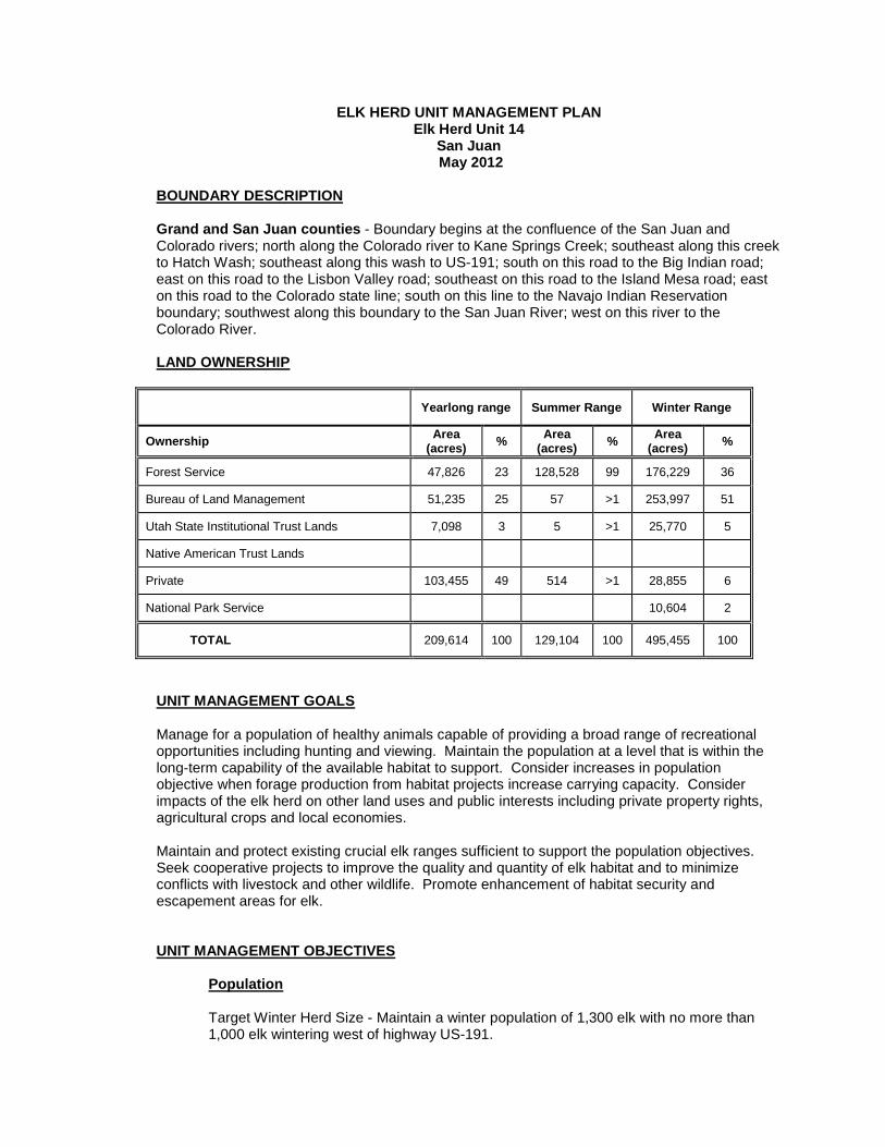
LAND OWNERSHIP
Yearlong range Summer Range Winter Range
Ownership Area (acres) % Area
(acres) % Area (acres) %
Forest Service 47,826 23 128,528 99 176,229 36
Bureau of Land Management 51,235 25 57 >1 253,997 51
Utah State Institutional Trust Lands 7,098 3 5 >1 25,770 5
Native American Trust Lands
Private 103,455 49 514 >1 28,855 6
National Park Service 10,604 2
TOTAL 209,614 100 129,104 100 495,455 100
UNIT MANAGEMENT GOALS
Manage for a population of healthy animals capable of providing a broad range of recreational opportunities including hunting and viewing. Maintain the population at a level that is within the long-term capability of the available habitat to support. Consider increases in population objective when forage production from habitat projects increase carrying capacity. Consider impacts of the elk herd on other land uses and public interests including private property rights, agricultural crops and local economies. Maintain and protect existing crucial elk ranges sufficient to support the population objectives. Seek cooperative projects to improve the quality and quantity of elk habitat and to minimize conflicts with livestock and other wildlife. Promote enhancement of habitat security and escapement areas for elk.
UNIT MANAGEMENT OBJECTIVES
Population
Target Winter Herd Size - Maintain a winter population of 1,300 elk with no more than 1,000 elk wintering west of highway US-191.
Bull Harvest Age Objective - Maintain an average bull harvest age of 7.5–8.0 years old on limited entry hunts.
Habitat
Summer Range - Maintain and improve summer forage availability on the Abajo Mountains and Elk Ridge through aspen regeneration and oakbrush thinning projects. Approximately 8,600 acres will be targeted for treatment over the next 5 years. Winter Range - Maintain and improve winter foraging areas through browse regeneration and pinyon-juniper removal projects. Approximately 18,700 acres will be targeted over the next 5 years.
CURRENT STATUS OF ELK MANAGEMENT
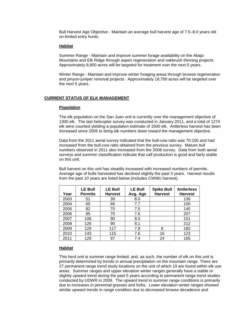
Population
The elk population on the San Juan unit is currently over the management objective of 1300 elk. The last helicopter survey was conducted in January 2011, and a total of 1274 elk were counted yielding a population estimate of 1500 elk. Antlerless harvest has been increased since 2005 to bring elk numbers down toward the management objective.
Data from the 2011 aerial survey indicated that the bull-cow ratio was 70:100 and had increased from the bull-cow ratio obtained from the previous survey. Mature bull numbers observed in 2011 also increased from the 2008 survey. Data from both aerial surveys and summer classification indicate that calf production is good and fairly stable on this unit. Bull harvest on this unit has steadily increased with increased numbers of permits. Average age of bulls harvested has declined slightly the past 3 years. Harvest results from the past 10 years are listed below (includes CWMU harvest).
Year LE Bull Permits
LE Bull Harvest
LE Bull Avg. Age
Spike Bull Harvest
Antlerless Harvest
2003 51 39 8.0 136 2004 69 66 7.7 100 2005 82 70 7.5 140 2006 95 70 7.6 207 2007 106 90 8.0 151 2008 126 90 8.1 212 2009 129 117 7.8 8 182 2010 143 115 7.6 16 123 2011 129 97 7.4 24 165
Habitat
This herd unit is summer range limited, and, as such, the number of elk on this unit is primarily determined by trends in annual precipitation on the mountain range. There are 27 permanent range trend study locations on the unit of which 19 are found within elk use areas. Summer ranges and upper elevation winter ranges generally have a stable or slightly upward trend during the past 5 years according to permanent range trend studies conducted by UDWR in 2009. The upward trend in summer range conditions is primarily due to increases in perennial grasses and forbs. Lower elevation winter ranges showed similar upward trends in range condition due to decreased browse decadence and
increased herbaceous cover. Elk use on these low elevation ranges has been relatively light, particularly in mild winters that have allowed elk to winter at higher elevations. Interagency spring range transects have shown slight increases in utilization by elk. USFS and BLM range assessments of current vegetative trends on the unit have not indicated over utilization by elk. Competition with domestic livestock is also important factor that determines the number of elk on this unit. This unit could most likely support a larger elk population, however, given the current livestock grazing rates, social and political climate, and lower deer population status, the current population management objective is at the acceptable level. Completion of habitat projects to improve forage availability for both elk and cattle would allow potential increases in the elk population. Several habitat improvement projects have been completed or are planned by federal agencies, UDWR, and private landowners. HABITAT PROJECTS COMPLETED AND PROPOSED
Completed Projects – 2007 through 2012 Proposed Projects – 2013 to 2018
Blue Creek P-J burn USFS (2008-2009) 500 acres Drill Hole P-J/brush burn
USFS 315 acres
Deadman-Duck Lake PIPO managed fire USFS (2009) 700 acres Shingle Mill P-J treatment
USFS 2000 acres
Chimney Park Rx burn USFS (2011) 450 acres Johnson Creek P-J/PP thin,
burn USFS 3600 acres
Brushy Basin chaining maint USFS (2011-2012) 1600 acres North Elk Ridge Rx burn
USFS 1300 acres
Little Baullies chaining maint. BLM (2010) 900 acres Maverick Point PP, Oak, P-J
treatments USFS 2500 acres
Shay Mesa P-J thin/burn BLM (2011) 1300 acres North Elk Ridge aspen
restoration USFS 1500 acres
Shingle Mill P-J treatment USFS 4100 acres
Peters Point Ridge chaining maint USFS 1000 acres
Devil-Bulldog PP thin USFS 1500 acres
South Long Point Rx burn USFS 1500 acres
Peters Point P-J thin BLM 8000 acres
Recent forest fires and timber management operations have provided some new forage areas for elk. Recent emphasis on energy development could impact elk habitat on this unit. An increase in exploration and extraction activities could potentially fragment existing elk habitat and displace elk to less productive areas. Crop depredation by elk on this unit has increased primarily during the summer on croplands east of highway US-191. Monetary damages have been significant on crops such as sunflower, corn and beans. These damage problem areas are often adjacent to

CWMU units with large elk numbers. Some landowners are reluctant to enroll these properties in CWMUs because they feel that participation in the CWMU program does not adequately compensate them for losses sustained from elk depredation. The CWMUs have recently participated in compensating landowners for crop damages adjacent to their units. The southeast portion of this unit is being managed under general open bull and liberal antlerless harvest strategies to alleviate depredation problems in this area. Antlerless removal on the CWMUs has been increased over the past 5 years to address these depredation situations.
BARRIERS TO ACHIEVING UNIT MANAGEMENT OBJECTIVES
Population
Big Game / Livestock Competition - Resistance of livestock operators to increasing elk herds and concerns of impacts from large elk population to struggling deer population. Lack of public understanding of habitat relationships between elk and livestock.
Crop Depredation - Chronic crop depredation problems could result in reducing elk numbers in specific areas. Harvest Age Objective - Maintaining high bull numbers to achieve harvest age objective and reduction of antlerless population to achieve population objective. Public resistance to increasing numbers of bull hunting permits to reduce average age of harvest. Landowner Participation in Cooperative Wildlife Management Unit Programs – Resistance of landowners to join CWMU units because of a lack of knowledge of the program or because of inadequate compensation from CWMU operators for crop depredation losses.
Habitat
Drought - Impact of prolonged drought to range condition and forage availability. Limited Summer Range - Amount of quality summer habitat for foraging and reproductive activities is limited and shared with livestock and other big game. Habitat Loss – Plant succession changes in important summer areas (conifer encroachment in aspen stands) and winter areas (pinyon-juniper invasion in mountain brush-sagebrush communities) reduces forage for elk. Lack of browse regeneration and invasion of annual grasses on lower elevation winter ranges also impact habitat quality. Other Barriers
Elk Distribution - Congregation of large elk herds on some areas may result in excessive utilization and could displace deer herds to less productive ranges. Land Resource Activities - Impacts from habitat fragmentation and disturbance as a result of energy development and timber management activities. Predation - The San Juan Unit has healthy black bear and cougar populations. Black bears are known to take elk calves and cougars will prey on all ages of elk. With that said, predation does not appear to have a significant impact on elk survival rates on this unit.

Illegal Harvest - Extent of illegal harvest on this unit is unknown, but because of the unit’s reputation for trophy-quality animals, the potential for illegal activities is elevated. Illegal harvest of mature bulls has the potential to affect the availability of limited entry permits. Disease - Chronic wasting disease has been documented in deer and elk on the adjacent La Sal Mountain range and in deer on the Abajo Mountains.
STRATEGIES FOR REMOVING BARRIERS AND REACHING UNIT MANAGEMENT OBJECTIVES
Population Monitoring
Population Size - The population is monitored using harvest data, aerial trend counts and classification, preseason classification, and survival estimates. Investigate and incorporate research findings on differential sightability of cow-calf groups, spike bulls, and mature bulls during aerial surveys.
Bull Age Structure - Monitor age class structure of the bull population through the use of checking stations, uniform harvest surveys, field bag checks, preseason classification and aerial classification.
Harvest - The primary means of monitoring harvest will be through the statewide uniform harvest survey. The target population size will be achieved through antlerless harvest using a variety of harvest methods and seasons.
Management Actions to Remove Population Barriers
Big Game/Livestock Competition - Continue to work with land management agencies and public grazing operators, as well as private landowners to assure that proposed population objectives are reasonable and attainable. Antlerless harvest will be the primary strategy utilized to achieve and maintain population objectives and to address specific habitat concerns and depredation problems. Keep public informed of deer and elk population trends and incorporate elk management strategies that have minimal impacts to the deer population. Educate the public about habitat and dietary overlap between elk and livestock. Crop Depredation - Work with private landowners to make sure depredation is maintained within tolerable levels and will not become a limiting factor. Utilize depredation hunts, fencing and other actions where appropriate to reduce/mitigate crop depredation. Consider other options for attaining antlerless harvest east of highway US-191 such as reciprocal agreements on CWMUs
Harvest Age Objective - Continue public relations to provide information on effect of changing permit numbers in relation to average age of harvested bulls. Continue spike-only bull hunts to increase hunting opportunities.
Habitat Monitoring
Habitat Condition and Trend – Continue analysis of trends in habitat condition through permanent range trend studies, pellet transects, and field inspections. Land management agencies will similarly conduct range monitoring to determine vegetative trends, utilization and possible forage conflicts. Range trend studies will continue to be conducted by DWR to evaluate elk habitat health and trend. Conduct range utilization studies in areas of perceived conflicts to evaluate competition between elk and livestock.
Management Actions to Remove Habitat Barriers
Limited Summer Range - Work with public land management agencies to develop specific vegetative objectives to maintain the quality of important elk use areas. Respond to any range deterioration concerns and address documented excessive forage utilization. Continue to investigate and develop habitat projects on summer range to improve forage availability for both elk and cattle. Habitat Loss - Cooperate with federal land management agencies and private landowners in carrying out habitat rehabilitation projects such as reseedings, controlled burns, water developments etc. on public and private lands to maintain or increase forage quantity and quality.
Management Actions to Remove Other Barriers
Elk Distribution - Utilize antlerless harvest in specific areas when necessary to target elk concentrations impacting range conditions and/or important deer areas. Land Resource Activities - Continue to coordinate with land management agencies and energy development companies in planning and evaluating resource uses and developments that could impact habitat quality. Work to develop and administer access management plans for the purposes of habitat protection and escape or “security” areas. Predation - Maintain hunting seasons to control bear and cougar populations. Maintain high quality summer habitats to protect important calving areas (see “Management Actions To Remove Habitat Barriers”). Illegal Harvest – Implement action plans to focus law enforcement efforts in areas where illegal bull harvest has been documented. Disease - Continue testing of harvested animals to detect presence of CWD in the elk population.
ELK HERD UNIT MANAGEMENT PLAN Elk Herd Unit 15 Henry Mountains
May 2012
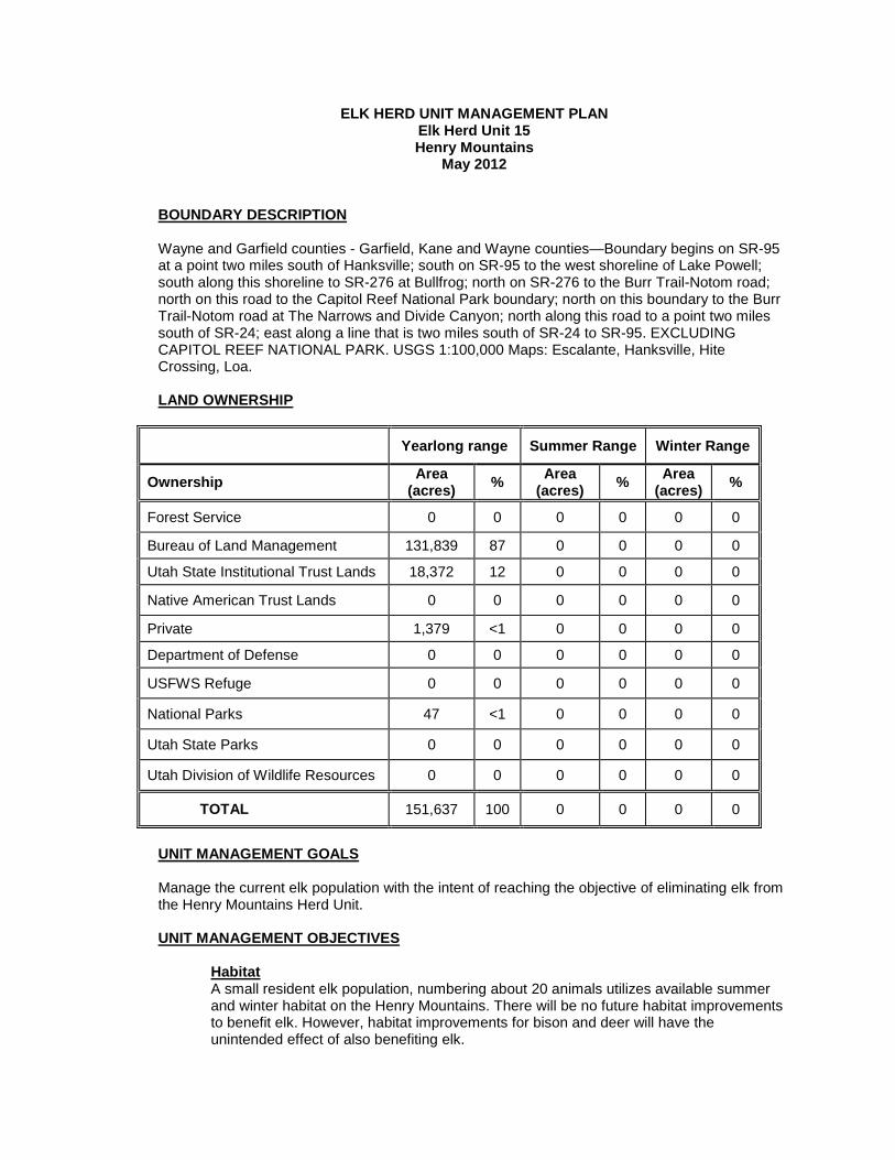
BOUNDARY DESCRIPTION
Wayne and Garfield counties - Garfield, Kane and Wayne counties—Boundary begins on SR-95 at a point two miles south of Hanksville; south on SR-95 to the west shoreline of Lake Powell; south along this shoreline to SR-276 at Bullfrog; north on SR-276 to the Burr Trail-Notom road; north on this road to the Capitol Reef National Park boundary; north on this boundary to the Burr Trail-Notom road at The Narrows and Divide Canyon; north along this road to a point two miles south of SR-24; east along a line that is two miles south of SR-24 to SR-95. EXCLUDING CAPITOL REEF NATIONAL PARK. USGS 1:100,000 Maps: Escalante, Hanksville, Hite Crossing, Loa. LAND OWNERSHIP
Yearlong range Summer Range Winter Range
Ownership Area (acres) % Area
(acres) % Area (acres) %
Forest Service 0 0 0 0 0 0
Bureau of Land Management 131,839 87 0 0 0 0
Utah State Institutional Trust Lands 18,372 12 0 0 0 0
Native American Trust Lands 0 0 0 0 0 0
Private 1,379 <1 0 0 0 0
Department of Defense 0 0 0 0 0 0
USFWS Refuge 0 0 0 0 0 0
National Parks 47 <1 0 0 0 0
Utah State Parks 0 0 0 0 0 0
Utah Division of Wildlife Resources 0 0 0 0 0 0
TOTAL 151,637 100 0 0 0 0
UNIT MANAGEMENT GOALS
Manage the current elk population with the intent of reaching the objective of eliminating elk from the Henry Mountains Herd Unit. UNIT MANAGEMENT OBJECTIVES
A small resident elk population, numbering about 20 animals utilizes available summer and winter habitat on the Henry Mountains. There will be no future habitat improvements to benefit elk. However, habitat improvements for bison and deer will have the unintended effect of also benefiting elk.
Habitat
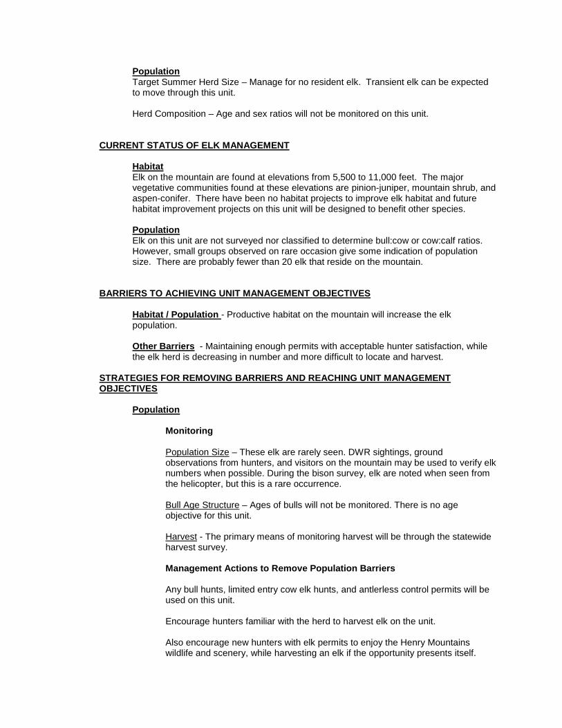
Target Summer Herd Size – Manage for no resident elk. Transient elk can be expected to move through this unit.
Population
Herd Composition – Age and sex ratios will not be monitored on this unit.
CURRENT STATUS OF ELK MANAGEMENT
Elk on the mountain are found at elevations from 5,500 to 11,000 feet. The major vegetative communities found at these elevations are pinion-juniper, mountain shrub, and aspen-conifer. There have been no habitat projects to improve elk habitat and future habitat improvement projects on this unit will be designed to benefit other species.
Habitat
PopulationElk on this unit are not surveyed nor classified to determine bull:cow or cow:calf ratios. However, small groups observed on rare occasion give some indication of population size. There are probably fewer than 20 elk that reside on the mountain.
BARRIERS TO ACHIEVING UNIT MANAGEMENT OBJECTIVES
Habitat / Population
- Productive habitat on the mountain will increase the elk population.
Other Barriers
- Maintaining enough permits with acceptable hunter satisfaction, while the elk herd is decreasing in number and more difficult to locate and harvest.
STRATEGIES FOR REMOVING BARRIERS AND REACHING UNIT MANAGEMENT OBJECTIVES
Population
Monitoring
Population Size
– These elk are rarely seen. DWR sightings, ground observations from hunters, and visitors on the mountain may be used to verify elk numbers when possible. During the bison survey, elk are noted when seen from the helicopter, but this is a rare occurrence.
Bull Age Structure
– Ages of bulls will not be monitored. There is no age objective for this unit.
Harvest
- The primary means of monitoring harvest will be through the statewide harvest survey.
Management Actions to Remove Population Barriers
Any bull hunts, limited entry cow elk hunts, and antlerless control permits will be used on this unit. Encourage hunters familiar with the herd to harvest elk on the unit. Also encourage new hunters with elk permits to enjoy the Henry Mountains wildlife and scenery, while harvesting an elk if the opportunity presents itself.
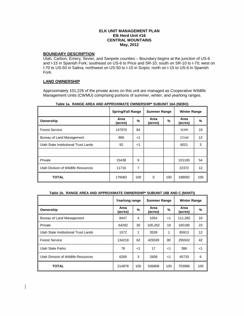
ELK UNIT MANAGEMENT PLAN Elk Herd Unit #16
CENTRAL MOUNTAINS May, 2012
Utah, Carbon, Emery, Sevier, and Sanpete counties – Boundary begins at the junction of US-6 and I-15 in Spanish Fork; southeast on US-6 to Price and SR-10; south on SR-10 to I-70; west on I-70 to US-50 in Salina; northwest on US-50 to I-15 in Scipio; north on I-15 to US-6 in Spanish Fork.
BOUNDARY DESCRIPTION
LAND OWNERSHIP Approximately 101,226 of the private acres on this unit are managed as Cooperative Wildlife Management Units (CWMU) comprising portions of summer, winter, and yearlong ranges.
Table 1a. RANGE AREA AND APPROXIMATE OWNERSHIP* SUBUNIT 16A (NEBO)
Spring/Fall Range Summer Range Winter Range
Ownership Area (acres) % Area
(acres) % Area (acres) %
Forest Service 147970 84 36390 19 Bureau of Land Management 866 <1 23144 12
Utah State Institutional Trust Lands 92 <1 6021 3
Private 15438 9 101165 54 Utah Division of Wildlife Resources 11716 7 22372 12
TOTAL 176082 100 0 100 189092 100
Table 1b. RANGE AREA AND APPROXIMATE OWNERSHIP* SUBUNIT 16B AND C (MANTI)
Yearlong range Summer Range Winter Range
Ownership Area (acres) % Area
(acres) % Area (acres) %
Bureau of Land Management 8447 4 1054 <1 111,282 16
Private 64292 30 100,262 19 165180 23 Utah State Institutional Trust Lands 1572 1 3539 1 85913 12 Forest Service 134218 62 429328 80 295502 42
Utah State Parks 78 <1 17 <1 386 <1
Utah Division of Wildlife Resources 6269 3 2608 <1 45733 6
TOTAL 214878 100 536808 100 703996 100
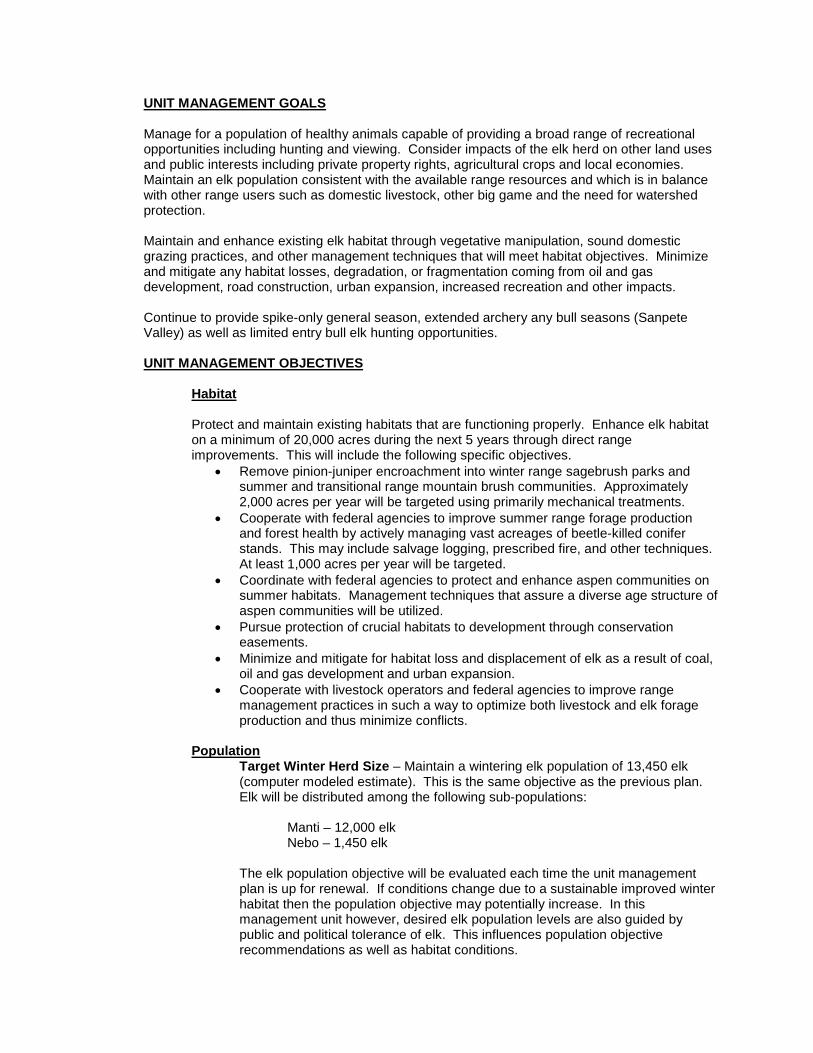
UNIT MANAGEMENT GOALS
Manage for a population of healthy animals capable of providing a broad range of recreational opportunities including hunting and viewing. Consider impacts of the elk herd on other land uses and public interests including private property rights, agricultural crops and local economies. Maintain an elk population consistent with the available range resources and which is in balance with other range users such as domestic livestock, other big game and the need for watershed protection.
Maintain and enhance existing elk habitat through vegetative manipulation, sound domestic grazing practices, and other management techniques that will meet habitat objectives. Minimize and mitigate any habitat losses, degradation, or fragmentation coming from oil and gas development, road construction, urban expansion, increased recreation and other impacts. Continue to provide spike-only general season, extended archery any bull seasons (Sanpete Valley) as well as limited entry bull elk hunting opportunities. UNIT MANAGEMENT OBJECTIVES
Habitat
Protect and maintain existing habitats that are functioning properly. Enhance elk habitat on a minimum of 20,000 acres during the next 5 years through direct range improvements. This will include the following specific objectives.
• Remove pinion-juniper encroachment into winter range sagebrush parks and summer and transitional range mountain brush communities. Approximately 2,000 acres per year will be targeted using primarily mechanical treatments.
• Cooperate with federal agencies to improve summer range forage production and forest health by actively managing vast acreages of beetle-killed conifer stands. This may include salvage logging, prescribed fire, and other techniques. At least 1,000 acres per year will be targeted.
• Coordinate with federal agencies to protect and enhance aspen communities on summer habitats. Management techniques that assure a diverse age structure of aspen communities will be utilized.
• Pursue protection of crucial habitats to development through conservation easements.
• Minimize and mitigate for habitat loss and displacement of elk as a result of coal, oil and gas development and urban expansion.
• Cooperate with livestock operators and federal agencies to improve range management practices in such a way to optimize both livestock and elk forage production and thus minimize conflicts.
Target Winter Herd Size – Maintain a wintering elk population of 13,450 elk (computer modeled estimate). This is the same objective as the previous plan. Elk will be distributed among the following sub-populations:
Population
Manti – 12,000 elk
Nebo – 1,450 elk The elk population objective will be evaluated each time the unit management plan is up for renewal. If conditions change due to a sustainable improved winter habitat then the population objective may potentially increase. In this management unit however, desired elk population levels are also guided by public and political tolerance of elk. This influences population objective recommendations as well as habitat conditions.
Herd Composition –Maintain an average age of harvested bulls between 5.5-6.0 years old on the Manti Subunit and 6.5-7.0 on the Nebo Subunit. Utilize general season spike-only hunting and limited entry any bull hunting to accomplish herd composition objectives. Utilize extended archery any bull hunting to address depredation/public safety issues in Sanpete Valley.
CURRENT STATUS OF ELK MANAGEMENT
Habitat
Habitat Conditions:
There are 64 permanent range trend study locations on the Central Mountains Manti Subunit and an additional 19 transects read on the Nebo Subunit. The Nebo and the western portions of Manti subunits were last read in 2007. The eastern portion of the Manti Subunit was read in 2009. Most range trend locations target winter ranges for deer but in many cases show trends in elk winter range productivity. Most range trend sites across the unit show declining trends in browse density and cover, particularly on the west side of the Manti. This was due in part to a large die-off of shrubs in this area between 2002 and 2004. Additionally, there are localized areas that get high utilization by deer and elk that contribute to declines in browse production. Grass and forb trends have been stable to slightly declining across the unit over the past 15 years. The average of all of the DCI scores on elk winter ranges suggest the winter elk habitat is in Fair condition.
Cooperative DWR/BLM/USFS spring range rides have shown relatively stable elk utilization patterns on winter ranges with some localized areas being over utilized. Most winter ranges should benefit from a mild winter in 2011-12 with very few deer and elk on typical wintering areas. Elk summer habitat appears to be in stable condition. Domestic sheep graze much of the summer range on the unit. Although there may be localized competition between sheep and elk, stocking rates are well below historical averages. Summer ranges are also impacted by fairly high recreation use during the summer months. This tends to displace elk from portions of important summer range. When looking at elk population objectives, the Division has taken into account barriers which include, 1) depredation issues 2) winter range that is beyond division control 3) social and political factors 4) current range improvements 5) future range improvements and 6)overall range health. As these factors change, the Division will adjust the population objective as needed.
Factors limiting elk populations:
Drought is the primary factor that impacts elk populations. Forage production and vigor is severely limited during drought years. Current and future oil and gas development as well as urban expansion will continue to fragment existing elk habitat and displace elk to less productive areas. Conflicts between elk and domestic livestock operators are also a primary limiting factor. This can be a volatile sociopolitical issue. This occurs in the form of crop depredation in farmlands as well as perceived competition for forage on rangelands. Elk numbers may be maintained at levels below the stated objective if excessive levels of crop depredation or forage consumption on private rangelands occur.
Habitat projects completed and proposed: Federal agencies, private landowners and the UDWR have cooperated on habitat improvement projects targeted at various wildlife species that have also benefited elk. Below is a list of current and future projects.
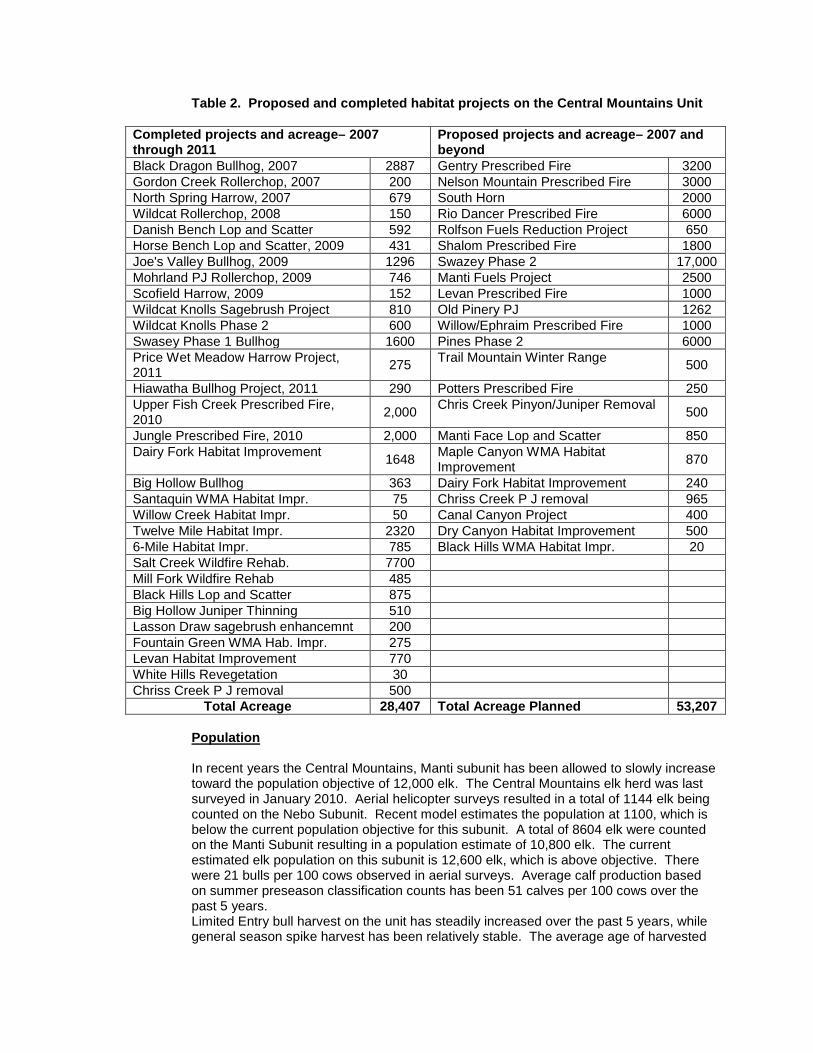
Table 2. Proposed and completed habitat projects on the Central Mountains Unit
Completed projects and acreage– 2007 through 2011
Proposed projects and acreage– 2007 and beyond
Black Dragon Bullhog, 2007 2887 Gentry Prescribed Fire 3200 Gordon Creek Rollerchop, 2007 200 Nelson Mountain Prescribed Fire 3000 North Spring Harrow, 2007 679 South Horn 2000 Wildcat Rollerchop, 2008 150 Rio Dancer Prescribed Fire 6000 Danish Bench Lop and Scatter 592 Rolfson Fuels Reduction Project 650 Horse Bench Lop and Scatter, 2009 431 Shalom Prescribed Fire 1800 Joe's Valley Bullhog, 2009 1296 Swazey Phase 2 17,000 Mohrland PJ Rollerchop, 2009 746 Manti Fuels Project 2500 Scofield Harrow, 2009 152 Levan Prescribed Fire 1000 Wildcat Knolls Sagebrush Project 810 Old Pinery PJ 1262 Wildcat Knolls Phase 2 600 Willow/Ephraim Prescribed Fire 1000 Swasey Phase 1 Bullhog 1600 Pines Phase 2 6000 Price Wet Meadow Harrow Project, 2011 275 Trail Mountain Winter Range 500
Hiawatha Bullhog Project, 2011 290 Potters Prescribed Fire 250 Upper Fish Creek Prescribed Fire, 2010 2,000 Chris Creek Pinyon/Juniper Removal 500
Jungle Prescribed Fire, 2010 2,000 Manti Face Lop and Scatter 850 Dairy Fork Habitat Improvement 1648 Maple Canyon WMA Habitat
Improvement 870
Big Hollow Bullhog 363 Dairy Fork Habitat Improvement 240 Santaquin WMA Habitat Impr. 75 Chriss Creek P J removal 965 Willow Creek Habitat Impr. 50 Canal Canyon Project 400 Twelve Mile Habitat Impr. 2320 Dry Canyon Habitat Improvement 500 6-Mile Habitat Impr. 785 Black Hills WMA Habitat Impr. 20 Salt Creek Wildfire Rehab. 7700 Mill Fork Wildfire Rehab 485 Black Hills Lop and Scatter 875 Big Hollow Juniper Thinning 510 Lasson Draw sagebrush enhancemnt 200 Fountain Green WMA Hab. Impr. 275 Levan Habitat Improvement 770 White Hills Revegetation 30 Chriss Creek P J removal 500
Total Acreage 28,407 Total Acreage Planned 53,207
Population
In recent years the Central Mountains, Manti subunit has been allowed to slowly increase toward the population objective of 12,000 elk. The Central Mountains elk herd was last surveyed in January 2010. Aerial helicopter surveys resulted in a total of 1144 elk being counted on the Nebo Subunit. Recent model estimates the population at 1100, which is below the current population objective for this subunit. A total of 8604 elk were counted on the Manti Subunit resulting in a population estimate of 10,800 elk. The current estimated elk population on this subunit is 12,600 elk, which is above objective. There were 21 bulls per 100 cows observed in aerial surveys. Average calf production based on summer preseason classification counts has been 51 calves per 100 cows over the past 5 years. Limited Entry bull harvest on the unit has steadily increased over the past 5 years, while general season spike harvest has been relatively stable. The average age of harvested
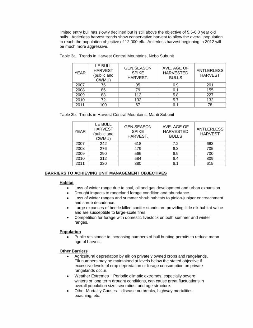
limited entry bull has slowly declined but is still above the objective of 5.5-6.0 year old bulls. Antlerless harvest trends show conservative harvest to allow the overall population to reach the population objective of 12,000 elk. Antlerless harvest beginning in 2012 will be much more aggressive. Table 3a. Trends in Harvest Central Mountains, Nebo Subunit
YEAR
LE BULL HARVEST (public and
CWMU)
GEN.SEASON SPIKE
HARVEST.
AVE. AGE OF HARVESTED
BULLS
ANTLERLESS HARVEST
2007 76 95 6.9 201 2008 86 79 6.1 155 2009 88 112 5.8 227 2010 72 132 5.7 132 2011 100 67 6.1 78
Table 3b. Trends in Harvest Central Mountains, Manti Subunit
YEAR
LE BULL HARVEST (public and
CWMU)
GEN.SEASON SPIKE
HARVEST.
AVE. AGE OF HARVESTED
BULLS
ANTLERLESS HARVEST
2007 242 618 7.2 663 2008 276 479 6.3 705 2009 290 566 6.9 700 2010 312 584 6.4 809 2011 330 380 6.1 615
BARRIERS TO ACHIEVING UNIT MANAGEMENT OBJECTIVES
• Loss of winter range due to coal, oil and gas development and urban expansion. Habitat
• Drought impacts to rangeland forage condition and abundance. • Loss of winter ranges and summer shrub habitats to pinion-juniper encroachment
and shrub decadence. • Large expanses of beetle killed conifer stands are providing little elk habitat value
and are susceptible to large-scale fires. • Competition for forage with domestic livestock on both summer and winter
ranges.
• Public resistance to increasing numbers of bull hunting permits to reduce mean age of harvest.
Population
Other Barriers
• Agricultural depredation by elk on privately owned crops and rangelands. Elk numbers may be maintained at levels below the stated objective if excessive levels of crop depredation or forage consumption on private rangelands occur.
• Weather Extremes - Periodic climatic extremes, especially severe winters or long term drought conditions, can cause great fluctuations in overall population size, sex ratios, and age structure.
• Other Mortality Causes – disease outbreaks, highway mortalities, poaching, etc.
STRATEGIES FOR REMOVING BARRIERS AND REACHING UNIT MANAGEMENT OBJECTIVES
Habitat
Monitoring • Continue to monitor permanent range trend studies throughout the winter
range. • Annually inspect rangeland vegetative community impacts and health
through cooperative DWR/BLM habitat assessment surveys that include ocular field assessments, utilization transects, and range rides.
• Continue to develop and implement Habitat Management Plans for UDWR owned properties on the unit.
Actions to Remove Habitat Barriers
• Cooperate with federal agencies to establish natural fire policies that will allow wild fires to burn in beneficial and non-threatening areas to recover lost elk habitat.
• Continue to improve forage production on winter and other shrublands by aggressive pinion-juniper removal.
• Cooperate with federal agencies to assure a diverse age structure of aspen communities on summer habitats.
• Pursue Conservation Easements on critical parcels of private property to protect important elk habitat from development.
• Work with oil and gas interests to attempt to protect key areas and minimize or mitigate for losses due to development.
• Cooperate with federal agencies to develop access management plans to enhance elk habitat value. This may include seasonal road closures or vehicle restrictions.
• Involve livestock operators in spring range rides and assessments in an effort to keep good relationships and address any potential concerns about competition between livestock and elk.
Population
Monitoring
Population Size - The population is monitored using harvest data, aerial trend counts and classification, preseason classification, and survival estimates.
Bull Age Structure - Monitor age class structure of the bull population through the use of annual preseason ground classification and winter aerial classification. Average age of harvest will be determined by tooth age data from L.E. harvest.
Harvest
- The primary means of monitoring harvest will be through the statewide uniform harvest survey and the mandatory harvest reporting for the L.E. hunts. Target population size will be maintained through the use of antlerless harvest using a variety of harvest methods and seasons.

Management Actions to Remove Population Barriers
• Target depredation hunts to address elk herds that habitually move into agricultural areas.
• Cooperate with private landowners to fence all haystacks and provide compensation when necessary in high winter depredation areas.
• Utilize antlerless hunts to address range concerns in specific areas. • Utilize depredation bull hunts and extended archery season options to
address depredation and public safety issues by bulls according to DWR depredation policy.
• Cooperate with UDOT to pursue funding to reduce vehicle mortalities.