Embed Size (px)
Citation preview

ELIZABETHAN POLICIES
AND THE
CHARLES TOWN COLONY:
AN ETHNOHISTORICAL-ARCHAEOLOGICAL ANALYSIS
by
Michael 0. Hartley, Sr.
A Thesis submitted to the faculty of The University of North Carolina at Chapel Hill in partial fulfillment of the requirements of the Master of Arts in the Department of Anthropology.
Chapel Hill
1986
Reader _
Reader

ii
MICHAEL 0. HARTLEY, SR. Elizabethan Policies and the Charles Town Colony : An Ethnohistorical-Archaeological Analysis (Under the direction of ROYS. DICKENS, JR~
Archaeology , within American Anthropology, has recently begun to
consider l iterate, historic cultures. There has, however, been a lag in
the joini ng of archaeology with anthropological use of documentary data
from hi storic contexts.
The central theme of this thesis is that an analytical combination
of written communications originating within a literate society with a
study of the archaeological remains of that society can increase the
understanding of both data bases. An increase in the understanding of
the data bases leads to an increase in an understanding of the culture
being studied. This is accomplished by using both types of data in a
complementary way to create a culture context, or historiography . The
historiography can be used to derive anthropological interpretations.
This is illustrated by combining primary documentation relating to
the processes of English sixteenth-eighteenth century colonization and
archaeological evidence of these processes observed on the Carolina
landscape.

iii
TABLE OF CONTENTS
Page
LIST OF FIGURES . . . . . . . . . . . . . . . . . . . . . . . . . . . . . . . . . . . . . . . . . . . . . . . . iv
ACKNOWLEDGEMENTS. . • . • • • • • • • • • • • • • . . • • • • • • • • • • • • • • • . • • • . . • • • • • . . v
CHAPTER I: INTRODUCTION. . . . . . . . . . . . . . . . . . . . . . . . . . . . . . . . . . . . . . . 1
Test Data.......................................... 11
CHAPTER II: THE ELIZABETHAN PLAN............................... 15
Notes On Colonization 1578......................... 15
Discourse Of Western Planting 1584................. 17
CHAPTER III:THE CHARLES TOWN COLONY............................ 21
Introduction ....................................... 21
English Reconnaissance............................. 23
Description of the Port............................ 27
Fortification...................................... 27
The Rivers. . . . . . . . . . . . . . . . . . . . . . . . . . . . . . . . . . . . . . . . . 28
Trade, Indians and the Spanish ................ ~.... 29
Skins. . . . . . . . . . . . . . . . . . . . . . . . . . . . . . . . . . . . . . . . . . . . . . 34
Archaeology. . . . . . . . . . . . . . . . . . . . . . . . . . . . . . . . . . . . . . . . 37
CHAPTER IV: DISCUSSION. . . . . . . • . . . . . • • . . . . . . . . • . . . . . • . . • . . . . . . . . 41
The Charles Town Model. . . . . • . . . . . . . . • • . . . . . . . . • . . . . 44
Hypotheses. . . . . . . . . . . . . . . . . . . . . . . . . . . . . . . . . . . . . . . . . 46
The English Model. . . . . . . . . . . • . . . . . . . . . . . . . . . . . . • . . . 54
Other Pertinent Models............................. 56
CHAPTER V: SUMMARY. . . . . . . . . . . . . . . . . . . . . . . . . . . . . . . . . . . . . . . . . . . . 62
REFERENCES CITED. . . . . . . . . . . . . . . . . . . . . . . . . . . . . . . . • . . . . . . . . . . . . . . 69

iv
LIST OF FIGURES
Figures Page
1. Charles Town in Relation to the Spanish Lands................. 47
2. Infilling Between James Town and Charles Town and
Expansion of the Competitive Boundary Through Georgia......... 48
3. A Portion of the 1695 Thornton-Morden Map Showing
Charles Town and the Ashley River............................. 49
4. Seventeenth Century Sites Located in the Ashley
River Survey. . . . . . . . . . . . . . . . . . . . . . . . . . . . . . . . . . . . . . . . . . . . . . . . . . 50
5. Initial English Attempts to Colonize, Circa
1585. The "Lost Colony"...................................... 51
6. Stages of the English Model................................... 52

v
ACKNOWLEDGMENTS
The Department of Anthropology, University of North Carolina, Chapel
Hill, has provided much of the academic environment which made this paper
possible. I would particularly like to acknowledge the guidance and
patience of my co~ittee, Roy Dickens, Carole Crumley and Bob Daniels.
Each has made a valued contribution. Other faculty and fellow students
have also contributed by providing an intellectual community which
supports scholarly exploration.
The Institute of Archaeology and Anthropology, University of South
Carolina, Columbia has also provided such an atmosphere. Additionally,
the Institute provides a valued logistics and administrative foundation
for such projects as the seventeenth century survey in South Carolina.
Stanley South of the Institute has been a mentor, colleague and
friend through the years. This paper would not have been written without
his pioneering efforts. Jolee A. Pearson also contributed substantially
to the archaeological examination of seventeenth century Charles Town and
her work is appreciated.
The South Carolina Department of Archives and History provided grant
monies which allowed field work in the Charleston area. This kind of
support is extremely important and is appreciated.
Various archives in South Carolina and North Carolina have provided
the documentation necessary to this paper. Thanks to Caroliniana Library
at the University of South Carolina and Davis Library at the University
of North Carolina for providing these resources.

ACKNOWLEDGEMENTS (cont.)
Thanks to Geri Cox for excellent manuscript preparation.
Thanks to my wife Margaret for her patience.
vi
Finally, thanks to those Carolinians who realize the value of
developing knowledge about our past and recognize its relationships to
our present.
'

CHAPTER I
INTRODUCTION
A traditional aspect of anthropology has been that its primary area
of inquiry is among non-literate, so-called "primitive" peoples
(Honigmann 1976:195). This limitation is not inherent in the tenets of
the discipline but is rather the result of the historical development of
anthropology. During the developing years, anthropology contained a
salvage attitude which focused on observing and recording the behaviors
of non-literate and less complex societies before they disappeared into
the complex society of the nineteenth-and-twentieth-century world.
Additionally, there was the belief that simpler societies contained
information on integration, roles, and types of social relationships
which could not be observed elsewhere (Honigmann 1976:396). Some
anthropologists--Spier, Kroeber, Lowie, and others--rejected the idea of
limiting anthropological study to the primitive, stating that
anthropologists study .culture wherever and whenever found, restricted to
no special segment but considering the totality (Taylor 1967:37-38).
Within anthropology, archaeology has been regarded as having similar
limitations, committing itself to an examination of prehistory (Honigmann
1976:254). Only very recently has inquiry into historic or literate
cultures been regarded as a legitimate area of study for the
archaeologist. Around 1960, such scholars as J.C. Harrington, Clyde
Dollar, Bernard Fontana, and James Deetz began to press for acceptance of
Historic Sites Archaeology (Schuyler 1972:118-124).

2
On the forefront of the move to legitimate historical archaeology
has been Stanley South. South founded the Conference on Historic Sites
Archaeology in 1960 (South 1983:iii), he has been a prolific field
researcher and has generated new and innovative methodologies for the
recognition of pattern reflective of human behavior in the archaeological
record (South 1977:xiv).
In South's approach to historical archaeology there is a reluctance
to use the literate record of the culture under study in any extensive
way, preferring to leave the synthesis of these materials to the
"historian" (South, personal communication). The value of the
documentary data base for South has primarily been to direct the
archaeologist toward particular contexts, where archaeological methods
could reveal a class of data not present in the written record. This
material could then be analyzed to produce cultural information otherwise
unavailable (South, personal communication).
South's conceptual framework is evolutionary theory, in which
patterned regularity is abstracted from the material record and
synthesized. These demonstrated regularities are often expressed as
being empirically lawlike, with the explanation of these lawlike
regularities being the goal of archaeology (South 1977:xiii). The
explanation of regularities lies in the testing of hypotheses with new
data from the archaeological record which, says South, produces an
understanding of culture process and eventually new theory (South
1977:xiii).
With this procedure as basic to archaeological science, it follows that the use of ethnographic data and historical documentation does not result in a different kind of archaeology merely because a wider data base is available ... Many colleagues assume historical archaeology

is a particularistic involvement with details of history, cataloging, and classification (South 1977:xiii).
3
South is not alone in this approach, since all archaeologists are
faced with the task of understanding cultural .meanings in the material
record. This goal of developing a "material literacy" does not preclude
the anthropological use of other sources of data, however, if the uses of
such data do contribute to the understanding of culture. South's stance
has, in part, been a reaction to the uses to which historical archaeology
has been put in the past, i.e., verification of the historical record and
production of lists of artifacts which were given no meaning beyond a
mention of their relationship to specific places and people.
It is argued here that this failure of archaeologists to move beyond
the historically specific to the level of anthropological generality, by
combining the material and written record, is not attributable to the
nature of either data base but to their methodological application. It
is further argued that a combination of written communications of a
literate society with the material remains of their behavior can alter
the comprehension of both data bases on the general level.
In his seminal work, A Study of Archaeologly, Walter Taylor included
a discussion of the relationship between archaeology, history, and
anthropology which culminated with a statement of the need for
historiography or "the construction of cultural contexts" which he
regarded as basic to cultural anthropology, and a necessary preliminary
step to "doing" cultural anthropology (Taylor 1967:39). Taylor contended
that ethnology is actually historiography, not anthropology, the
difference being a concern for cultural context in the case of ethnology
and a major concern with culture itself in anthropology. Only if the
student makes use of his cultural context for the purpose of deriving and
4
comparing cultural abstractions is the practice of anthropology
accomplished (Taylor:39).
Taylor perceived the data from archaeological excavation as being no
different from other cultural data, even though the archaeological record
is, for the most part, not an intentional or purposeful record. The
result of archaeological data acquisition should be (1) compiled into an
historiography, which is (2) interrelated and integrated into a cultural
context (Taylor:41).
When the archaeologist collects his data, constructs his cultural contexts and on the basis of these contexts proceeds to make a comparative study of the nature and working of culture in its formal, functional and/or developmental aspects, then he is 'doing' cultural anthropology and can be considered an anthropologist who works in archaeological materials. The fact that his subject matter is American Indians or non-literate Britons does not, of itself, make his work anthropological. Nor does the fact that he uncovers and studies written inscriptions make his work non-anthropological. The critical test is what the archaeologist does with his discoveries, not his subject matter (Taylor:41).
With these considerations in mind, it is argued here that the
written record is not the special province of the historian and that the
anthropologist should address these data. Carole Crumley (1974) has
presented a framework for the construction of a composite model of Celtic
social structure using classical Roman ethnographies combined with
archaeological data. This work demonstrates the value of this combined
approach for the generation and testing of hypotheses not available in
the singular application of either body of data. In Crumley's study the
written data did not originate within the culture under study and was in
the form of ethnographic observation recorded by "outside" Roman
observers (Crumley 1974:3-8).
5
There is another class of literary data peculiar to the historic
period available to the anthropologist, the primary document. Primary
documentation, as it is used here, refers to literary documentation
originating in the culture which is being studied anthropologically as
opposed to secondary data such as ethnographic observation or a synthesis
produced by a historian. The use of primary documentation by the
anthropologist will result in a secondary statement which is comparable
to the recorded observations of the ethnographer to the extent that the
data base is produced directly by the culture being studied and is
directly reflective of that cultural context. The act of producing the
secondary synthesis or historiography interposes a bias disassociated
from the culture under consideration in that the structure of the
synthesis is determined by the questions and intentions of the observer.
By approaching the communications of the subject culture as directly as
possible, the filters of bias and heuristic structure can be reduced.
Such communications were frequently, although not always, produced
without consideration of their historical meaning. The internal
operation of a society through its day-to-day and year-to-year activities
encompassed a wide range of cultural elements. Bias is not absent in the
communications associated with these activities and they contain
inaccuracies, lies and other human foibles. Perhaps, however, these
biases are no greater than those of ethnographer's informants. If the
examination of these types of documents takes potential biases into
consideration, valuable "inside" cultural information can be derived.
There may be differences in interpretations and meanings of
vocabulary and linguistic structure between the primary writer and the
observer because of time, space, and cultural distinctions and these
6
complications are heightened if the scholar is using primary
documentation in a language other than his own. The scholar working in
his own language should be sensitive to the possibility of other meanings
than those which might occur most readily, but no anthropological
observer enters the process of observation with a certain knowledge of
meanings and intentions of the culture being studied. At the same time
the guard of objectivity must not be so extreme as to render
unintelligible the communications available.
An advantage of creating cultural contexts from primary
documentation may lie in the fact that it removes the anthropologist from
the environment in which the communication is created. Communications
produced by members of a culture who are unaware of the scrutiny of the
anthropologist or the historian may be less self-conscious. The
anthropologist also has available in primary documentation a body of data
that can range from broad policy statements pertaining to functions of
state to the most intimate communications of personal diaries or letters.
This data base is complex, as it contains many perspectives and biases,
but it is not unmanageable.
This thesis will utilize historical (or written) documentation in
combination with archaeological data to examine aspects of English
culture ca. 1570 to ca. 1730. At this time England was actively involved
in the export of its culture to the New World through colonization.
Englishmen had at that time developed a tradition of literacy in elements
of its population which was used for intracultural communications, record
keeping, and a range of academic and literary purposes.
Literary materials originating in England during this period are
from a distinctly different cultural perspective than that which current
7
scholars bring to bear on the same subject matter. Primary documents of
the sixteenth, seventeenth, and early eighteenth centuries are of
particular interest to anthropologist studying English culture of that
period as these documents contain thought and communications created
within that culture for the use of that culture. The documentation
available is extensive and includes subjects as diverse as statements of
broad governmental policy to particularistic communication about personal
and private life.
Because of the tradition of literacy within this nation-state,
access to cultural information is available in the form of recorded
thought and intra-cultural communications which is not available for the
observation of non-literate groups . The presence of varied biases and
positions within this range of material does not alter its characteristic
of originating within the English culture, and in fact such diversity
increases the richness of the data base for the consideration of this
particular culture and of culture in general . Since the perspective
contained in primary written material is not available to the current
scholar in its original sense, a perspective reserved to the primary
author, a metalevel of perception must be derived. The original
perception can never be duplicated or reconstructed and what the scholar
must accomplish is a synthetic perception of a perception. In the stud y
at hand our own participation in the English tradition of literacy (to
the extent that Elizabethan and other writings in that tradition remain
current) diminishes certain problems of comprehension.
It is in this way that the use of documentation as applied here
differs from Crumley's approach to the study of Celtic society and
culture (Crumley 1974). In that study much of the documentation

8
originated at the ti~e and place under consideration, but the
observations were made by Romans rather than by Celts, the subject
population and culture (Crumley 1974:3-14). As recorded by the Romans,
these observations exist on the synthetic level of ethnography
(extra-cultural observation and perception) rather than as the
transmission of written information between members of the subject
culture (intra-cultural communication).
Certain observations made by the English writers of the colonial
period are both primary and synthetic. An example is an English
colonist's written observations of American Indians of the seventeenth
century. While such a document is primary relative to a consideration of
the Englishman's culture and perspective, it is synthetic relative to the
Englishman's observation of Indian culture, particularly if
interpretations are present. The observation did not originate with the
Indian and interposes the Englishman's bias, and it may provide a more
direct observation of the Englishman than of the Indian. The written
perceptions of Indian society and culture will always contain an
intervening level of observation' imposed by contemporary non-Indian
observers, with the modern scholar imposing an additional level of bias.
Without a tradition of literacy, Indian society left very little written
record composed by its members in their own thought, language, and text.
The most direct access to primary thought of the Indian culture on a
general level is through the material remains left by the culture and
observable through methods of archaeology. With English culture, the
anthropologist has available literate thought combined with material
behavioral results, each originating in the culture and together being
synergistically related.

9
The Elizabethan period constitutes the earliest temporal range of
this paper and apart from a brief orienting statement of context the
Elizabethan will be considered in the works of two colleagues and
cousins, both named Richard Hakluyt.
The two cousins participated in the culture of post-reformation
England in a time after England had severed formal ties with Catholicism.
Translation of the Bible into English and the thrust of religious
reformation had led to a florescence of individual thought and
exploration in England. During the first half of the sixteenth century
England took little part in the exploration of the New World, and it
appeared that control ?f these new lands would fall to Spain and
Portugal. The coronation of Elizabeth I in 1558 brought England nearly a
half-century of stability during which it finally could pursue goals of
colonization, a pursuit which was encouraged by the Queen (Shafer
1944:271).
A shift from the Mediterranean to the Atlantic as the all important
ocean highway suddenly repositioned England in terms of cultural
geography. England was transformed from a remote border state on the
fringes of activity to a position directly in the mainstream of new
activity on Atlantic sea routes (Shafer 1944:271).
English sailors, encouraged by Queen Elizabeth, moved rapidly to
closed the exploration gap and to launch explorations in the 1580s and
1590s. English seamen began to rob the Spaniards of their gold and
silver by capturing Spanish treasure ships and by raids on Spanish
colonial coastal settlements (Bigges 1589; Shafer 1944:271). This piracy
was favored by Elizabeth I as a method of undeclared warfare against a
great and dangerous Catholic power. The pirates, regarded as national
10
heroes, included such men as Sir Francis Drake, Sir Martin Frobisher, Sir
John Hawkins, Sir Humphrey Gilbert, and Gilbert's half brother Sir Walter
Raleigh (Shafer 1944:271).
The two Hakluyts were at the core of this effort of the English as
the nation entered into competition for the New World. So closely tied
together that it is difficult to determine which produced certain
documents, the Hakluyts consciously formalized general models to guide
exploration and to form policy statements that reached the highest levels
of decision making in the nation.
Using the techniques of the cosmographer and the historiographer,
the Hakluyts gathered information on past and current colonial activities
by European powers on the coast of North America, translated these
materials into English, and compiled them under the title Diverse Voyages
to America (Hakluyt 1582). As they gathered this information along with
intelligence reports from English seamen in Spanish employ (Hawks 1572)),
the Hakluyts formulated generalizations to guide English policy.
Two basic Hakluyt documents, Notes On Colonization (Hakluyt 1578)
and the Discourse Of Western Planting (Hakluyt 1584), will be paraphrased
in Chapter II. The Discourse was prepared at the request of Walter
Raleigh (Hakluyt 1584:211). It was not meant for public eye, but rather
it was intended to gain support of the Queen and provide a textbook on
colonization for Sir Francis Walsingham, the English Secretary of State
(Taylor 1935:12,22). Walsingham had previously communicated the
importance of the Hakluyt's work in a letter to one of the cousins,
saying
your studie in these things is very commendable, so I thanke you much for the same, wishing you to continue your trouble in these and like matters which are like to turn

not only to your owne good in private, but to the publike benefit of this Realme (Walsingham 1583:196-197).
The two Hakluyt works state general goals of English colonial
activity and identify sets of general procedures for attaining these
goals. Notes On Colonization (1578) deals with elements of the
individual colony, whereas the much longer and more comprehensive
Discourse (1584) identifies strategic goals and procedures. Taken
11
together they constitute a generic model of the individual colony and the
use of such colonies in broad strategic contexts.
Based on the Hakluyt works, the following hypothesis is proposed:
Elizabethan policy makers formulated an explicit model for English
colonization of the New World with specific reference to geographical
location and English behavior relative to geographical location.
Examination of subsequent English colonial activity should reveal a
closeness of fit between actual activity on the landscape and those
behaviors called for by the general model.
Test Data
Data on the 1670 English colony of Charles Town, South Carolina are
used to test the above hypothesis. Communications originating within the
culture being examined are the preferred source of documentary
information. Secondary synthetic statements by authorities will also be
considered as necessary to illustrate various points in the discussion.
Archaeological remains of colonial behavior are primary data in the
important context of geographical location and physiography. These data
will be used in combination with documentation to produce a
historiographic statement of culture context about the Charles Town
colony.

12
These data are not presented in the detailed manner of a field
report. Ongoing field work has focused on seventeenth-century Charles
Town, South Carolina, a major data base for the following paper.
Reference to the reports from these surveys will provide added detail on
methodologies, sites, artifacts and other archaeological information
(South and Hartley 1980; Hartley 1984). It is not the purpose of this
paper to replicate this data. The purpose here is to show
interrelationships between historical and archaeological data rather than
to present a detailed treatment of the archaeological record itself.
Further, Kenneth Lewis has used data from South Carolina to
elucidate aspects of colonial frontier expansion, with a focus on the
eighteenth century. Although, Lewis's models provide valuable tools, in
this paper an effort is made to account for patterns not observed by
Lewis. Such divergencies require explanation, and Lewis provides a point
of departure for raising questions beyond the scope of his models .
Several groups of primary records are available as resources in the
comparison of Charles Town activities to the behaviors proscribed in the
Elizabethan model. One important group of documents, known as The
Shaftesbury Papers (Cheves 1897) pertain to the first years of activity
of Charles Town. A final introductory comment about Lord Shaftesbury
will be helpful.
Anthony Ashley Cooper, Lord Ashley, the Earl of Shaftesbury was the
Lord Proprietor of the Carolina colony most interested in the enterprise
in the first years. Shaftesbury seems to have been more keenly
interested in matters of English trade and overseas expansion than any
other major politician of his day (Haley 1968:227). Trade and
colonization were ''indissolubly'' linked after the restoration of the

English monarchy and following the dissolution of the Cromwellian
government. At this time, when the Carolina colony was becoming a
reality, the politically powerful Shaftesbury was able to exercise
influence over English colonial policy.
13
Shaftesbury's grandfather had been a member of the Virginia Company,
and Shaftesbury was related to Walter Raleigh by marriage. It has been
suggested that this relationship directed Shaftesbury's interests toward
the southern area of English colonial activity (Haley 1968:230).
Shaftesbury's private entry into active colonization began with a share
of a Barbados sugar plantation in 1646, and part ownership of a trading
ship the same year (Haley 1968:230).
In 1663, Shaftesbury and seven other powerful Englishmen were .
granted a Royal Charter for the colonization of Carolina, at a time when
Shaftesbury himself was entering his most active and influential period.
Between 1667 and 1674, Shaftesbury was Chancellor of the Exchequer, one
of England's Treasury Commissioners, and in 1672 he became president of
the English Council of Trade and Plantations (Haley 1968:227,231). This
newly created Council is reported to have one important change in policy,
a new Navigation Law of 1673 to close certain loopholes in England's
control of colonial shipping. Otherwise, the Council functioned as an
intelligence center and made no major changes in English colonial policy.
It has been suggested that this inactivity was deliberate on
Shaftesbury's part (Haley 1968:260-262).
Shaftesbury, along with his secretary, the philosopher John Locke,
and the seven other Proprietors brought Charles Town into being during
that period. The Shaftesbury Papers (Cheves 1897) contain a variety of
communications, instructions, constitutions, inventories, accounts, and
14
other records, written by members of the colony and by interested parties
in England.
This body of documents contains many and diverse perspectives.
These documents are given a commonality through Shaftesbury's interest,
participation, and direction.
The purpose of this thesis is to identify models the members of the
subject society had about their qwn culture. These concepts are
pertinent to our understanding and perceptual contexts as scholars of
their culture. In these considerations, individuals such as the Hakluyts
and John Locke should be recognized as insightful theoreticians. This
points out a need for scholarly humility when approaching the study of
any culture.

CHAPTER II
ELIZABETHAN PLANS
Thy Voyages Attend Industrious Hakluyt!
Whose reading shall inflame Men to seek fame,
And much commend to after times thy wit.
from To the Virginian Voyage (Michael Drayton, 1563-1631) (Shafer 1944)
Notes On Colonization (Hakluyt 1578).
In this treatise, Hakluyt proposed that the first seat in an area to
be colonized should be chosen on the seaside so that the navy could be
harbored within a bay, river, or lake, which would protect it from the
elements and an enemy (116). This seat should be located on an island in
the mouth of a notable river, or if an island was not available on a
point of land entering into the river. The river was to be navigable or
portable far into the interior for purposes of planting, trading, and
communicating with the various native groups (122).
Colonists were to make observations about the soil types and what
each type yielded naturally and by endeavor. This information was to be
sent to the parent country so that a determination might be made about
how to use it for trade (119). If the soils near the seat were found to
be marshy or boggy they were to be drained to use the rich soils (121).
The presence of gold, silver, copper, quicksilver or other precious
metals was not necessary at the site of the colony but could be supplied

16
from other locations by sea. Necessary materials were lime, slate or
clay to make tiles from, stone or brick to wall with, reeds for roofing
if tile or slate was not available, and timber for construction (117).
The seat was to be located in a temperate climate with sweet water
where the necessities of life would grow (117). The climate and soil of
the place were most important for the development of commodities (118).
Familiarity with the "Inland people" (natives) was a primary
objective. By developing such a relationship the colonists would be able
to discover all the natural commodities of the country, as well as all
the wants of the inland people, all of their strengths and all of their
weaknesses. The relations between the various groups of native peoples
were to be ascertained, particularly what confederations existed, who was
at peace and who was at war with whom. When these things were known,
said the model, the colonists could "woorke many great effects of
greatest consequence" ( 118).
If the port was fortified on the land side as well as on the ocean,
even though the nearest native population was unfriendly, trade could be
established by sea or the navigable river with a more distant group. In
this way the nearer group could be forced into friendship (120-121).
Humanity and courtesy as well as forbearance of revenge was to be used
with the inland people (118).
If trade was assured, even from the limits of a fortified city, the
colony would increase its wealth, the navy would be increased and an
alternative offered against times of trouble in the mother country.
Access to a large territory would free England from dependence on other
European nations for necessary goods, enriching her doubtful friends
(120) .

17
The colony was to sustain itself by the production of commodities
which would draw sea trade to it from England. The vessels of this trade
were also expected to have military capability against any enemy force
(117-118).
The rivers were to be used for the transportation of English goods
to the inland people and to bring their inland commodities to the port
(118). A well chosen location might in time become the central port for
the commodities of a large territory and become the seat of government
for all the provinces around (121).
A specific list of commodities needed immediately in Elizabethan
England was included in this plan, and in addition to the variety of
suggested agricultural products, trade with the "savages" for hides and
leather was recommended. Timber and fish were to be exploited while
experim~ntal planting was undertaken to develop a commodity (119-121).
Discourse Of Western Planting (Hakluyt 1584).
This document is a discussion of the broader context that would
incorporate colonies established on the plan described in Notes On
Colonization. Intellig_ence gathered by English seamen in the employ of
Spain focused on the area the English were interested in colonizing. One
of these seamen actually accompanied Spanish admiral Pedro Menendez de
Aviles on his 1565 colonizing expedition to mainland Florida (Taylor
1935:9). The English regarded the Spanish presence on mainland North
America and the expansion of the Spanish colonial system as highly
detrimental. This central issue in broad English colonial policy was
well developed in the Discourse. Although this document comprises 112
pages of printed text and is too lengthy to completely examine here,
several points are pertinent to this discussion.

18
The treatise begins by ignoring the presence of the Spanish town of
Santa Elena at Port Royal (now South Carolina) and stating that the
continent from 30 degrees North latitude in Florida to 63 degrees North
latitude was in no Christian prince's possession. It recommended English
planting in that area for the sake of the "savages" (Hakluyt:214-215) .
Santa Elena, at 32 degrees 15 minutes North latitude had been in
existence for eighteen years when Hakluyt wrote this document and had
been the capital of Spanish Florida (Lyon 1984:1-12). The Discourse
further stated that the Spanish had curtailed English trade with new
wealth and might acquired in their colonies and were mortal enemies of
the English (Hakluyt 1584:219). The voyage of Sebastian Cabot from
Florida northward to 67 degrees North latitude was cited as giving just
title of that part of America to England (Hakluyt 1584:222). This claim
was also allied to the theory of ''effective occupation'', which was to
become basic to English colonial activity (Florio 1580:165). [In
accordance with this theory, England conceded to other countries only
those lands which they actually occupied, claiming for herself the right
to conduct trade and establish colonies in unoccupied regions (Parker
1963:xvi).] Observations of the coastline by various European seamen
were cited to illustrate the potential for employing England's increasing
population, many of whom were poor and idle (Hakluyt 1584:233-239).
After identifying the area of activity, the Discourse addressed the
strategic issues of English colonization on the coastline. This is the
crux of the discussion, beginning with the recognition of Spanish
expenditures in the Azores to protect the homeward route of the West
Indian gold convoys. Hakluyt proposed to establish two or three strong
English forts (as described in Notes) on good harbors between Florida and
19
Cape Briton (just north of Nova Scotia) that could inflict damage on
Spain's fleets and her holdings in the West Indies (Hakluyt 1584:240;
italics added). The Discourse noted that the current of the Bahama
channel, used for Spain's homeward voyages, flowed against the coast
proposed for English occupation, and that this current and the
southeastern winds would force the Spanish fleet close into the shore
where the English would be strongly settled (Hakluyt 1584:240).
Hakluyt further observed that the Indians of Florida were the
Spaniard's mortal enemies and would join the English against the Spanish.
He reported that the Spanish greatly feared the arming of these Indians
and he therefore recommended that the English enter into alliances with
them and provide them with arms (Hakluyt 1584:240-241). He felt that the
Spanish were maintaining their colonies with a very weak force and that
the region of the West Indies abounded with people who rejected the
"proude and bluddy" government of the Spanish (Hakluyt 1584:249-248).
Addressing the trade aspects of these proposals, the Discourse
indicated that the voyage from England to the proposed colonies was easy
and short which would increase the trade returns on merchant's
investments. Since the length of the voyage was only five to six weeks
through a temperate climate, such intercourse would increase England's
maritime capabilities (Hakluyt 1584:265,270). It was recommended that
England initiate the formal instruction of procedures of world
navigation. No man was to command voyages to the West Indies who had not
passed an examination on navigation (Hakluyt 1584:272).
Finally, Hakluyt urged that speed was of the essence because of
great competition from other European nations for the lands of the New
World (Hakluyt 1584:274). These policies were developed in conjunction

20
with England's initial efforts at colonization. The unsuccessful
attempts in the 1580s to establish a colony on the barrier islands of
North Carolina, then called Virginia, had brought England into the
competition. The attempts on the outer banks continued until 1590, when
John White revisited the site of the 1587 attempt and found only
archaeological residue of the vanished colony (Humber 1962:136). The
defeat of the Spanish armada in 1588 allowed England more freedom on the
seas and the attempts continued (Shafer 1944:272).
The English established their first secure foothold in 1607 with the
occupation and fortification of Jamestown, Virginia (Cotter and Hudson
1957). One of the last colonial acts of the younger Hakluyt was as a
patentee of the Virginia Company, chartered in 1606. This company
drafted the Instructions For The Virginia Colony which reflected the
policies formulated by the Hakluyts (Council 1606:492-496). The
Jamestown colony stood as the southernmost extension of permanent English
colonization on the North American continent until the sriccessful
occupation of Charles Town, South Carolina in 1670. Although the
Elizabethan colonizers of the late sixteenth and early seventeenth
centuries passed from the scene, their concepts did not, as will be seen
in an examination of the ~ata relating to Charles Town.

CHAPTER III
THE CHARLES TOWN COLONY
INTRODUCTION
In the preceding section, it has been demonstrated that the English
nation formalized a scheme of colonization in the sixteenth century. The
following section examines the Charles Town colony to determine its
closeness of fit to the general models formulated almost one hundred
years before it was founded.
Since the English did not arrive in an area that was culturally
vacant, the presence of the Spanish and the Indians must be considered.
Relationships between these groups and the English were central to the
course of the establishment of the colony.
The Spanish, with their extensive holdings in Central and South
America, claimed a virtual monopoly on trade in the New World. Spain
also claimed all of North America, basing this claim on the discoveries
of Spanish explorers and the 1492 treaty of Tordesillas. Also, De Soto
explored the lands of present-day South and North Carolina (De Pratter
and Smith 1980), and the Georgetown, South Carolina, area is thought to
be the location of De Allyon's short lived colony (Hoffman 1983:71).
A permanent settlement was established at St. Augustine on the east
coast of Florida in 1565, followed by Santa Elena at Port Royal in 1566.
The site of Santa Elena, on Parris Island, South Carolina, (38BU162) was
discovered by archaeologists in 1979, and has been ~he scene of a series
of excavations (South 1980,1982,1983,1984).

22
Several reasons have been proposed for the establishment of Spanish
fortified presidios such as Santa Elena. The most prevalent are that
they were designed to defend the Spanish frontier against attack by enemy
European naval forces, to provide a base for entrepreneurial activities,
and to protect the bullion convoys in the Florida straits (Dobyns
1980:20-21). It is also contended that Santa Elena was not founded for
the protection of the convoy route, but to secure the Spanish coastline
against other European colonizing interests (Hoffman 1983:70). Arguably,
an enemy presence at Port Royal would implicitly threaten the Spanish
convoy route. During the sixteenth century, English, French, and Dutch
attacked Spanish bullion ships. Using Caribbean bases for these
activities, ships of these nations intercepted the Spanish on the high
seas or seized wealthy colonial ports for ransom (Dobyns 1980:20). Port
Royal would be well placed to fit this pattern of behavior if occupied by
an enemy of Spain.
The first Spanish governor of Florida, Pedro Menendez de Aviles,
violently terminated French efforts to establish a foothold there, and
attempted to consolidate his control over Spanish Florida. His claim
encompassed an area extending from Chesapeake Bay to the southern tip of
the Florida peninsula and west along the Gulf coast to the Panuco River
in modern Mexico (DePratter and Smith 1980:68). In 1566, of 1,500
soldier and settlers who arrived in Florida, 250 soldiers and most of the
settlers went to Santa Elena at Port Royal (DePratter and Smith 1980:68).
Explorations were launched from Santa Elena to establish interior
forts in South Carolina and North Carolina and to obtain provisions from
the Indians (DePratter and Smith 1980:68). A mission was established in
the Edisto area some five leagues to the north of the presidia, but the
23
Indian populations resisted attempts to force them into Spanish religious
attitudes (Lyon 1984:4). In 1576 the Indians of Guale and Edisto joined
together and attacked Santa Elena, first killing Spanish in outlying
areas and then causing the population of the town to flee their burning
houses and fort (Lyon 1984:9-11). Although the fort and town were
rebuilt in 1577, increasing to sixty houses and four hundred residents,
it lost its status as "capital" of Spanish Florida (Lyon 1984:12-13;
South 1983:1).
In 1586 English forces under Francis Drake burned the sister town of
St. Augustine as part of a general raid through the Caribbean. Santa
Elena was threatened in this expedition but was saved by Drake's
unfamiliarity with the channels (Bigges 1589:270). As a result of these
raids and because of incessant problems with the Indians the settlers of
Santa Elena were withdrawn to St. Augustine in 1587 (Connor 1925; Gannon
1965:39).
This withdrawal did not end Spanish occupancy of Port Royal,
however. Missions stood on Parris Island and Edisto as late as 1655
(Crane 1981:5) in spite of violent uprisings by the Guale Indians on the
coast of Georgia (Gannon 1965:40-41). In 1674, the Spanish Bishop
Calderon reported that St. Catherine's had not only the Friars but also
"an officer with a good garrison of infantry" (Gannon 1965:64)
English Reconnaissance
England attempted to move south from Virginia in 1629 with a patent
granted by Charles I to Sir Robert Heath. The patent granted Heath the
lands on the east coast from 31 degree North latitude to 36 degrees North
latitude (from Florida to Virginia), extending west for the extent of the
continent. Heath was supposed to create a province and name it Carolina

24
(Charles I 1629:3). This patent was never successfully exercised, and
King Charles II revoked it in 1663 and issued a new charter to the Lords
Proprietors of Carolina (Charles II 1663:5) . . A reconnaissance voyage
ordered by gentlemen and merchants of Barbados interested in the proposed
colony set out in 1663, commanded by William Hilton. Hilton made
landfall at 32 degrees 30 minutes North latitude, about four leagues to
the north of "St. Ellens" or Santa Elena at Port Royal (Hilton 1663:18 ) .
Here Hilton met Indians who were very bold and familiar, used many
Spanish words, and were not impressed with Hilton's ordnance. He
reported that they must have been used to cannon for many years . The
Indians told Hilton that there were Spaniards at St. Augustine who
frequently came to Santa Elena both by land and sea (Hilton 1663:19).
While Hilton was at this location, a Spanish Captain with a detail
arrived to investigate a reported shipwreck. Hilton felt uneasy in the
Port Royal area, particularly on a visit to "St. Ellens", where the
behavior of the Indians caused him to fear treachery. This feeling was
perhaps heightened by his knowledge of the nearness of Spanish forces.
At "St. Ellens" Hilton observed a sentinel house, a large cross,
construction material, and the ruins of an old fort which encompassed
more than a half acre of land within the trenches (Hilton 1663:20-21).
Hilton assumed that this was the ruin of the French Charles Fort
which was temporarily occupied somewhere at Port Royal in 1562, but there
is the strong possibility that this was the ruin of Fort San Marcos, the
last fort of the town of Santa Elena. The ruin of a fort on Parris
Island was misidentified as Charles Fort by the Huguenot Society in 1925,
but excavations on the site have revealed the remains of the town of
Santa Elena and demonstrated that the fort ruin is Spanish (South 1980) .

25
From the context of Hilton's account this may also have been the ruin
which he saw at "St. Ellens".
After an attempt to establish the Carolina colony on the Cape Fear
in 1664 was unsuccessful (Vassall 1667) the venture was inactive for
several years . In 1666 Robert Sandford, secretary and chief register for
the Lords Proprietors made another reconnaissance into the Port Royal
area.
When Sandford left Port Royal after making his observations he left
the surgeon, Dr. Henry Woodward, to live with the Indians to learn their
language and their ways. Woodward had embarked with Sandford planning to
stay with the Indians if such an opportunity arose. The Cassique (Chief)
of Port Royal placed Woodward beside him on his throne, gave him a field
of maize and the sister of an Indian going with Sandford to tend
Woodward, prepare his food, and care for him for the sake of her brother
(Sandford 1666:78-79). This contact was to be of great importance to the
future colony at Charles Town. As Sandford traveled up the coast he
observed the mouth of Charles Town harbor which he named "River Ashley"
in honor of Lord Shaftesbury, Anthony Ashley Cooper (Sandford 1666:80).
Based on the Hilton and Sandford accounts, the Lords Proprietors
formulated articles of agreement in 1669 for the colonization of Port
Royal. They provided shipping, arms, ammunition, tools and provisions
for the colony (Proprietors 1669:91). A constitution was drafted by the
philosopher John Locke, secretary to Lord Shaftesbury (Locke
1669:93-117). Officials were appointed and a fleet of three ships
assembled (Proprietors 1669:117-132).
When the Port Royal expedition reached Barbados it reported that
there was much interest there in the colonization of Carolina (West

26
1669:157 ) . Old Caribbean hands on Bermuda, learning of the plans to
colonize Port Royal, advised against settlement of that harbor. They
said that the Spanish could collect a fleet at New Providence (in the
Bahamas), wait for a prevailing southeast wind and in three days "be in
the River of Port Royal on the back of your people" (Dorrell and
Wentworth 1670:161). Part of the reason for this argument was to
persuade the Proprietors to aid in the English colonization of New
Providence to add to the security of the mainland colony of Carolina
(Dorrell and Wentworth 1670).
The fleet made separate landfalls on the mainland coast because of a
storm and the experiences of each led to a reassessment of the
prospective location. Two vessels made land near Seewee Bay northeast of
Ashley River and Port Royal. There they found Indians who warned them
that Port Royal had recently been inhabited by the Westos, a violent
group of invading Indians. The Cassique said that Port Royal was
extremely dangerous and recommended that the English locate in his
territory of Kiawah (Ashley River). These ships sailed down to Port
Royal where Indians there also warned against the Westos and asked for
protection. A sloop was sent to investigate Kiawah and returned with a
favorable report. The decision was made to establish on Ashley River,
although some still favored Port Royal (Carteret 1670:165-168) .
The third vessel made landfall at about 31 degrees North latitude
and came to anchor at St. Catherine's Island to take on wood and water.
A group of seven men and two women went ashore and did not return. The
next day an armed party of Spanish marching to a drum came to the shore
and demanded the surrender of the vessel. The English in turn demanded
the return of their people, at which the ship "received a volley of

27
musket shott and a cloud of Arrows which ye Indians shott upright, & soe
they continued for an howre & a half" (Mathews 1670: 169).
The English had blundered into the Spanish mission at St.
Catherine's in Guale. This exchange began a conflict which characterized
competition for southern territorial expansion on the continent. At
first wind, the vessel weighed anchor and departed under a fierce fire
from shore, joining their expedition at Kiawah (Mathews 1670:169-171).
Description of the Port
After establishing themselves at Ashley River the colonists began
communicating their appraisal of the port to the Proprietors in England.
The climate was described as "sweet", with enough good land for millions
of people to live and work on, and the Proprietors were asked to send
more colonists (Sayle 1670:175-176). One colonist observed that they
were "settled in the very chaps of the Spaniard" (Dalton 1670:183). The
harbor and the settlement were described as having a good inlet when
properly understood. The town was on a point defended by the main river
on one side with a marsh on the other. The point joined to the mainland
by a neck of approximately fifty yards which was to be fortified. The
colonist's main objective was security because they were so near ''a
jealous and potent neighbor" (Owen 1670:197).
Fortification
The significance assigned to ordnance and fortification in this
enterprise is reflected in bureaucratic and personal communications. In
1669, Whitehall issued a warrant to the English Commissioners of Ordnance
to deliver cannon and equipment "for the defence of the plantation called
Carolina in the West Indies" (Whitehall 1669:93).

28
The Governor was ordered to choose a fitting place to build a fort
for the protection of the first town so that the guns of the fort could
command all of the streets (Proprietors 1669:120). Storage houses to
contain the stores of war, food, clothing, tools, etc., were to be
located within the fort (Proprietors 1669~127-128).
The Carolina Constitutions created a High Constable's Court to order
and determine all military affairs. All land forces, arms, ammunition,
artillery, garrisons, forts and "whatever belongs unto warr" were to come
under the jurisdiction of the High Constable. In time of actual war he
was to become the General of the Army, his twelve assistants becoming
Lieutenant Generals. A corresponding Admiral's Court oversaw ports,
navigable rivers and maritime affairs (Locke 1669:103).
By March 1670 the point of land had been palisaded and seven great
guns mounted. Additional guns were on hand but their carriages had been
lost in a wreck (Carolina Council 1670:283). These defenses were soon
tested when Spanish vessels and thirty piraguas of Spaniards and Indians
were reported at Santa Elena. The ships lay off the coast at Charles
Town to cut off English supplies, and the piragua force positioned itself
at the mouth of the Stono, intending to force a surrender. The English
supply ship managed to get through and the colonists believed that the
firing of the great guns in the town frightened off the Spanish Indians
(Woodward 1670:186-188). The people of Carolina felt more like soldiers
in a garrison than planters due to alarms of Spanish attack (Dalton
1670:183-184).
The Rivers
Item. That ye Inhabitants of ye said Country have free passage throughe or by any Seas bounds Creeks Rivers Rivelets &c in ye sd Pvince of Carolina through or by wch they

must necessarily pass to come from ye mayne Ocean to ye Countyes aforesd or any part of ye Province aforesaid (Yeamans 1664:48-49)
As the fortified town became established "discoveries" were
29
initiated on the river systems to determine the nature of these important
features. A shallop was sent up the Ashley River in the spring of 1671
and reported it navigable for that vessel twenty to thirty miles
upstream. A smaller boat went another thirty miles into the interior
(Mathews 1671:335). The north river (the Cooper) was explored in the
same period but had not been examined above fifteen miles by boat and
twenty or thirty by land. Many resources were noted in association with
both systems (Mathews 1671:335-336). To the southwest the Stono-Edisto
systems had previously been noted for ease of water travel (Sandford
1666:75).
In June of 1672 Lord Shaftesbury requested his agent to choose a
"Signiory" for him
either on the Ashley or Cooper River in a place of the greatest pleasantness and advantage for health and profit which must be where there is high Ground neare a navigable River and if it be above the tydes flowing tis the better (Shaftesbury 1672:406).
In 1983, archaeologists discovered the site described by Shaftesbury. It
was designated 38DR83 (Hartley 1984:23,25,36,73-75).
Trade, Indians, and the Spanish
The Proprietors instructed their agent in the colony to take a
variety of seeds, roots, sets, and vines in the first fleet, and on
arrival select a convenient location at the new town with as many soil
types as possible. This was to be an experimental plantation testing
varieties of plants in different types of soil. The "natives" were to be

30
asked the proper season to plant corn, beans, and peas. The primary
interest was to develop a crop which would provide provisions for the
colony, "ye foundation of yor Plantacon", while at the same time
experimenting with crops such as grapes, ginger, cotton, and indigo to
develop a marketable commodity (Proprietors 1669:125-127). By March of
1671, thirty acres of ground were cleared for the experimental
plantation, concentrating on provisions but also experimenting with
commodities (West 1671:267). This site was visited in 1983 and
designated 38CH680 (Hartley 1984:51-52).
The proximity of the Spanish and the immediate conflict between the
two groups disrupted these procedures. Faced with the need for
marketable commodities, the colony then turned to the Indians as a
solution to both problems. In anticipation of this need, the English had
earlier left Henry Woodward in Carolina to establish contact with the
Indians prior to the arrival of the colonists.
Dr. Woodward had remained "some considerable time" with the Indians
after Sandford departed the coast, until his presence at Santa Elena
reached the notice of the Spanish and he was taken to St. Augustine. He
did not remain a prisoner, for the buccaneer Captain Robert Serle raided
the town, freeing Woodward in the process. Woodward was taken by Serle
to the Leeward Islands where he shipped as surgeon on a privateer. This
ship wrecked on Nevis, where the Carolina fleet found him and he returned
to Carolina with the expedition (Carolina Council 1670:190-191).
This strange mixture of preplanning and romantic happenstance
resulted in a resource which the Council in Carolina regarded as
invaluable. Woodward had been extremely useful in the initial time of
scarce food, dealing with the Indians for needed provisions. Although he

expressed a desire to return to England to report directly to the
Proprietors, the Charles Town Council argued that they could not do
without his knowledge of the Indians and their languages (Carolina
Council 1670:191-192).
31
Shaftesbury instructed the government in Carolina that Woodward's
presence there was necessary to maintain the communication between the
colony and the Indians, and that Woodward should be "perswaded to stay
there where wee shall be sure to be mindfull of him" (Shaftesbury
167la:314-315). To Woodward, Shaftesbury wrote that no one else could be
so helpful to the new colony until the planters had learned the Indian's
languages and ways. Further, Woodward could expect financial rewards for
his contributions to the colony (Shaftesbury:167lb:315-316).
In addition to providing for immediate subsistence needs of the
colony, Woodward's knowledge allowed him to initiate the military
alliances with the Indians which the Carolinians needed to defend against
and then to move offensively on the Spanish. Woodward met Westo
emisaries at Shaftesbury's plantation on the upper Ashley River (38DR83)
and accompanied them to their village, believed to have been on the
Savannah River, where he negotiated a treaty with them (Woodward
1674:456-462; Hartley 1984). The treaty Woodward concluded with this
feared and armed warrior group (Bull 1670:194) initiated the use of
alliances with such powerful Indians to oppose the Spanish in the
contested lands of Port Royal, Savannah River, and Guale.
While Woodward was negotiating with the Westos, two Savannah Indians
who lived twenty days to the southwest came into the Westo town. They
brought Spanish beads and other trade and told Woodward they had engaged
in commerce with Whites "whom were not good" (Woodward 1674:461). Seven

32
years later, when the Westos became too recalcitrant for the English, the
colony allied with the Savannahs and destroyed the Westos. The Savannahs
then became the buffer tribe (Milling 1940:84).
Although the English colonists continued experimentation to
establish a marketable agricultural commodity, none emerged between 1670
and the 1690s. As the colony searched for an economic base Indians began
to be exploited as a commodity.
In September, 1671, Carolina officials reported that the Kussoe and
other southward Indians threatened the colony by the great quantity of
corn they were removing from the plantations. The government said that
the Kussoe refused to live quietly and peaceably, threatened the lives of
colonists, insolently invaded the plantations in the night time, and
threatened to join with the Spanish to destroy the colony. As a result
the colony declared open war against the Kussoes (Carolina Council
Journal 167la:341-342).
These Indians lived close to the harbor at Charles Town and had
villages on the Ashley, Steno, and Edisto Rivers (Cheves 1897:456-457) so
there were many occasions for conflict as the English established
themselves on the same rivers. The conflict developed into a brief
"Kussoe war", and the colonists sent out an expedition which resulted in
a number of Indian prisoners. The decision was made to either ~ransport
them or sell them back to their tribe for ransom, to be divided equally
among the company that had taken the prisoners (Carolina Council Journals
167lb:344-345). This documents the beginnings of the infamous Indian
slave trade which was to provide support for Carolina for many years to
come. Only in South Carolina did traffic in Indian slaves taken in war
reach commercial proportions, drawing from the tribes on the frontiers of

33
Florida and Louisiana (Crane 1981:109). The events of the Kussoe war
indicate that this trade began close to the colony.
These Indian wars were part of the conflict between the Charles Town
English and the Florida Spanish in a competition which the Indians would
lose no matter which European power won. The conflict was an extension
of a traditional West Indian confrontation and took place on sea as well
as land. Pirates used Charles Town and other colonies as a base to raid
Spanish shipping to the extent that the English crown issued an official
act against piracy (Salley 1946:24-25), and the Spanish retaliated with
pirates encouraged and harbored on their West Indian islands, according
to the English (Randolf 1700:186).
In 1686, in part as a retaliation against piracies, the Spanish
attacked and destroyed the newly established English town at Port Royal,
Stuart Town. Leaving the ruin of Stuart Town the Spanish force continued
the raid into the Edisto area within thirty miles of Charles Town harbor.
They raided and sacked the plantation and house of Governor Morton
(38CH238) and of Secretary Grimball (Salley 1904:108; South and Hartley
1980:66).
English-Indian raiding parties in turn forced the Spanish farther
south as the Charles Town colonists attempted to open a trade route south
of the Appalachians into the Mississippi (Nairn 1708:193-202; Crane
1981:39) (Figure 1). The Carolinians saw the colony as
a Frontier to the English settlements on the Continent of America ... also frequently menaced by the Governors of St. Augustine and the Havanna, with an invasion (Carolina 1706:171)
34
Skins
The second major commodity passing through the Charles Town port,
deerskin leather obtained in trade from allied, subjugated or friendly
Indians stimulated expansion toward Mississippi. In contrast with the
New York trade, which was for furs, Charles Town sent great quantities of
deerskins to London each year (Crane 1981:108-109). This commodity was
supplemented by the manufacture of pitch, tar, turpentine, masts, and
beef and pork, products which could be produced in the areas near the
port (Randolph 1699:92; Wilson 1682:29-31). Local subsistence was
achieved through the agricultural production of subsistence crops and the
taking of wild game and fish (Wilson 1682:27-28).
In the 1690s rice began to be produced in quantities sufficient to
become the agricultural staple commodity the colony had been searching
for (Randolph 1699:91-92). By 1699, the.Black population of the colony
was counted at "above 5000 slaves", who were to be employed in the
production of rice. This developing commercial capability was termed "of
the greatest concern to the English Navigation" and the need for
additional vessels for the transportation of the Carolina commodities was
reported to England (Randolph 1699:91-92).
As the war on the border escalated into the war of Spanish
Succession in the first years of the eighteenth century there were mass
migrations of Indians into and out of the contested area. Whole groups
of Indians were taken as slaves or slain. Under this pressure the
Spanish mission system collapsed and in 1708 the garrison at St.
Augustine was
Reduced to the bare wall their cattle and Indian towns all consumed Either by us in our Invasion of that place or by our Indian Subjects since who in quest of Booty are now obliged to
goe down as farr on the point of Florida as the firm land will permit they have drove the Floridians to the Islands of the Cape, have brought in and sold many Hundreds of them, and Dayly now continue that trade so that in some few years thay'le reduce these Barbarians to a farr less number, there is not one Indian Town betwixt Charles Town and Mowila Bay except what are prickt, in the map (Nairn 1708:196-197)
The successful introduction of rice culture coupled with the
expansion of trade, set the Carolina colony on a growing economic
35
foundation as it entered the eighteenth century (Sirmans 1966:55). New
populations of Europeans began to move into the protected area, between
Charles Town and Virginia, and the towns of Bath (1690), New Berne (1710)
and Edenton (1710) (Figure 2), as well as dispersed settlements began to
be seen in North Carolina (Powell 1968).
In 1711 the seaport of Beaufort, South Carolina was established in
Port Royal and the disputed·area began to fill with settlers.
Advertisements of the location in England pointed out its convenience in
carrying on the Indian trade (Crane 1981:165). The colony seemed to have
achieved stability, now secured in the Port Royal area by the heavily
armed Yamasee Indians.
The Yamasee Indians viewed the movement of settlers into the
frontier zone with alarm, complaining to the Indian Trade Commissioners
in Charles Town that they were afraid of their lands being taken away
(J.C.I.T. June 20, 1712:28). Instructions were given to the Port Royal
agent to confirm Yamasee rights to the land and to take the names of all
English who were improperly settled there (J.C.I.T July 9, 1712:31). The
agent was instructed about the Yamasee:
You know they are the Bulwark of this Settlement and persuant to your Instructions, suffer not the Traders to cheat and use them with Insolence inconsistent

with the Amity we profess and unbecoming the Dignity of the Government (J.C.I.T. July 17, 1713:47)
36
The abuses were not resolved to the satisfaction of the Yamasee, and
the Creeks to the west were also angry at the practices of the Carolina
traders. In April 1715, the Creeks were reported ready to kill the
traders and attack the settlement. On April 16, 1715 Indians of various
nations along the border and to the west had "shaken of their fidelity,
treacherously murdering many of His Majesty's subjects" (Boston News June
13, 1715; J.C.I.T. April 12, 1715:65).
In the war, nearly four hundred inhabitants of Carolina were killed,
including many slaves. Many houses and great numbers of cattle were
destroyed, this destruction heaviest near Port Royal. The inhabitants of
that area were entirely driven out and forced into settlements near
Charles Town (Yonge 1720:145). A ring of plantation garrisons was
established on a thirty-mile radius of Charles Town, including The Ponds
(38DR87) near the head of the Ashley River. This plantation was used as
a mustering ground for a successful counter attack on June 13, 1715
(Crane 1981:171-172; Hartley 1984:36-37, 94-95).
The Yamasee War reopened unrest on the Carolina-Florida border which
lasted approximately fifteen years and changed the nature of the colony
and the border. The events of the war, and the heightened awareness of
Carolina as the frontier of English colonial enterprise, resulted in it
becoming a Crown colony (Yonge 1720:141-192). With the assistance of
Virginia, the Carolinians forced the Yamasee into Guale and began the
heavy fortification of the Port Royal-Savannah boundary between the
mountains and the sea (Yonge 1720:145,192).

37
The English occupation of Guale in 1721 (Crane 1981:233) and the
subsequent creation of the colony of Georgia in 1733 (Sirmans
1966:169-170) allowed the rotation of the English-Spanish boundary toward
an east-west line lying just above 30 degree North latitude. This
isolated the Spanish in peninsular Florida with the exception of a rim of
control along the northern Gulf coast (Figure 2). In so doing the
English achieved the goal of the Hakluyts and laid the foundation for the
drive to the Mississippi where they would encounter the French.
Archaeology
Archaeology of the seventeenth-century colony at Charles Town is
being conducted in ongoing surveys which rest on a primary document, the
1695 Thornton-Morden map of Carolina (South and Hartley 1980; Hartley
1984). The 1695 map is a revision of the 1685 Mathews map of Carolina
and presents a perspective of the colony ranging over more than a decade
(Cumming 1962:162, 166; South and Hartley 1980:2-6).
The surveys are in part a test of the accuracy of the 1695 map and
its usefulness in locating archaeological sites of the period (South and
Hartley 1980). The accuracy of the map has been demonstrated in two
surveys where archaeologists have been able to locate approximately
thirty percent of the sites through simple surface search and no
subsurface testing. Comparison with current United States Geodetic
Survey maps revealed a strong correlation between current physiographic
features and those recorded on the seventeenth-century document. This
made the location of the sites shown on the 1695 map possible (South and
Hartley 1980; Hartley 1984) (Figures 3 & 4).
The Thornton-Morden map can now be used as an accurate
representation of the settlement pattern of higher-status groups of the
38
Carolina colony. Other groups, such as Blacks or poorer Whites, are not
represented, but the location of landed colonist's home sites is useful
as a point of departure in a search for remains of less visible and
systemically related populations (Hartley 1984:35-36).
These archaeological surveys have been grounded in an appreciation
of the general relationship between cultural needs of people and
physiographic factors, as was demonstrated by Joffre Coe (1964) in his
work on Yadkin River Archaic sites. This relationship between
physiographic features and human behavior allows the anthropologist to
hypothesize a predictable means for locating occupation sites, a
principal applied here to colonization of Carolina. One point of the
survey's design is to determine whether the sites shown on the map,
believed to have been occupied by persons of high status, would conform
to a hypothetical model of location on high ground contour adjacent to
~eep water channels (South and Hartley 1980:1-2,24).
In the survey area, this pattern was almost universal, so that the
sites which fell outside this model require an explanation of why they
were different (South and Hartley 1980; Hartley 1984). This hypothesis
identifies a norm, which then allows the identification of variation from
the norm (Hartley 1984:29). Variation from this norm keys certain sites
for further questions and examination. These sites served purposes which
fell outside the need for a navigable channel or high ground or were so
necessary at a certain location that these requirements were overridden.
The Ponds (38DR87), is such a site. It is located on the thirty mile
boundary of the colony on a bluff above Ashley River headwater swamps, as
recorded on the 1695 Thornton-Morden map. This site was used as a muster

39 ,
ground for a counter attack against the Yamasee in 1715 which indicates
its use as a point of communication back and forth across that boundary.
The archaeological surveys have revealed that the colony of Charles
Town in the seventeenth century was a large and dispersed community lying
within a half circle struck on a thirty-mile radius of Charles Town
harbor (Figure 1). The settlement lay along the river systems that
radiated outward from the harbor and that provided navigable roadways
connecting the outlying neighborhoods with the central business district
of the harbor. The majority of the sites located were within
five-hundred feet of a landing and at least ten feet above the high water
mark (South and Hartley 1980:24; Hartley 1984:29).
There are three major ri~er roadways radiating out from Charles Town
harbor. The Stano-Edisto system parallels the coast to the southwest for
thirty miles where it then penetrates into the interior and also connects
with Port Royal Sound. The Ashley River flows into the harbor from
headwater swamps which begin some twenty-five to thirty miles inland to
the northwest. A third river, the Cooper, runs into Charles Town harbor
from the north. This system has not yet been surveyed.
To the northeast, an anomalous French Huguenot settlement is located
on the Santee at a distance of thirty-five miles on the 1695 map. This
is the only settlement not shown on a river with inland connections to
Charles Town harbor (Hartley 1984:3). Although overland roadways are
seen on the 1695 map within the thirty-mile radius, the pattern of
settlement shown is almost entirely river oriented.
Charles Town was and is an excellent and well protected port, as
evidenced by its continued use to the present. The archaeological
examination of the first settlement at Charles Town on Old Towne Creek

40
revealed extensive fortification trenches, palisades, and earthworks
(South 1969; 1971). Recommendations for excavation in the village area
just north of these fortifications have not been followed (South
1969:48-49). This is a key site for understanding the initial 1670
English occupation (South 1969; Hartley 1984:38).
In the search for sites on both the Stono-Edisto and Ashley systems
a number of seventeenth-century sites were located on which descendants
of the original occupier were still living. This indicates the intention
of permanent settlement on the part of the colonists as well as a
cultural stability which has endured in the area for more than three
hundred years (South and Hartley 1980:30; Hartley 1984:27-28). The
completion of the Mark Clark expressway around the city of Charleston and
into John's Island will terminate much of this stability as the Sea
Islands begin to subdivide. The gross cultural change brought about by
urbanization was readily seen on the Ashley River sectipn of the survey
(Hartley 1984:29-33).
A hypothesis formulated for the Ashley River survey was that
neighboring Spanish populations should be archaeologically visible in
material collections from seventeenth-century English sites. Of the
sites located along the Ashley River, thirty percent were found to have
at least one Spanish potsherd present (Hartley 1984:28).

CHAPTER IV
DISCUSSION
In the above treatments two contexts, separate in time, have been
prepared for the same culture. The first is a general model prepared by
Elizabethan English in anticipation of colonization and frontier
expansion in the New World. The second is a sketch drawn from
information relating to the colonization and expansion of Charles Town,
South Carolina in the seventeenth-early-eighteenth centuries. The
purpose of this exercise was to determine if Charles Town fit the general
Elizabethan plan. Such a fit would broaden understanding of English
colonization to the level of generality, beyond a particularistic focus
on Charles Town alone. Relating this colony to the broader context of
English colonization should allow the application of data from Charles
Town to processes of English settlement. Inherent in these
considerations are questions of frontier expansion.
In comparing Charles Town with the Hakluyt's model contained in
Notes On Colonization (1578) one finds that the location of the colony
agrees with the physiographic and climatic characteristics of the model.
The colonists immediately instituted recommended procedures of
experimental planting to develop subsistence crops and a marketable
staple. Specific measures were taken to derive information from the
indigenous population. Non-agricultural staple commodities were
exploited while an agricultural commodity was developed, as prescribed in
the 1578 model. These commodities, non-agricultural and agricultural,

42
drew sea trade and increased English navigation. Using rivers and
overland communication between the harbor and the outlying regions,
Charles Town became the central port for a vast area of the South, as the
Hakluyts had designed. The population of the colony consistently
increased as excess populations of England, Europe, and the West Indies
sought a new home in Carolina.
In the context of the Discourse On Western Planting (1584), Charles
Town was a successful location of an English colony at the southern end
of the stated area of English operation. This colony was a major
expansion of English colonial activity to the south of Jamestown,
Virginia, and directly onto the hostile Spanish threshold, another stated
goal of the Hakluyts.
Also as proposed in the Discourse, the quickly fortified colony
immediately engaged the Spanish and began to force the expansion of the
English frontier and the collapse of the Spanish, a conflict which was
constant in both times of peace and times of war. These findings
indicate that the generalities recognized in the Discourse operated
through time and independently of the formal political stances of England
and Spain.
The predictions of the Discourse about the usefulness of the Florida
Indians in a conflict against the Spanish were entirely accurate one
hundred years after it was written. These groups were used effectively
against the Spanish by the English, attracted to the English by trade and
past Spanish abuses. The weakness of the Spanish in the West Indies and
Florida, observed in 1584, was in effect in 1670 and was exploited by the
English. Pirates, using Charles Town as a base of operations, preyed on
Spanish shipping.

43
The effective occupation of Charles Town laid the foundation for the
further occupation of Georgia, reducing Spanish holdings while expanding
the English frontier to 30 degrees North latitude. This was a major goal
specified in the Discourse.
This study demonstrates a close fit between the Elizabethan plan and
the activities of the Charles Town colonists. This indicates durability
of conscious processual plans over more than a century. There were
cultural mechanisms in English society which could account for the
durability of these ideas and a brief consideration of them is in order.
First, these ideas were formulated on a policy level in the English
state, which means that they were carried by high status individuals with
the political power to implement them. These plans were initially put
into operation by those who formulated them. The activities at Charles
Town one hundred years later indicate that these plans were still in
process, carried out by another generation of Englishmen.
The examination of the leadership of the Charles Town colony reveals
that members of that group were in the same class and on the same
political level as the formulators of the plans. Also, as evidenced by
Shaftesbury, · this group had family ties with the Elizabethans who
originated England's colonial venture. Family, class, and political
relations were strongly present as possible means for the transmission of
plans and attitudes.
Second, England's literary traditions provided an institutional
"memory" to insure the durability of these ideas, formalized into written
documents. These documents were maintained in a variety of archives,
both public and private, and were readily accessible to those acting on a
policy level. Accessibility was coupled with a tradition of use of such

44
documents. Both Elizabethans and the subsequent Carolina colonizers used
documents of this kind (Locke 1671:265-266).
This information also received a more popular dissemination in the
form of poetry, drama, and works designed to stimulate the English public
toward colonization. Through the literary tradition these ideas also
became known to some extent among a broader public (Carroll 1836; Shafer
1944).
One of the aspects of archaeology is the durability of cultural
information carried in the archaeological remains of human behavior.
Literary retention of cultural information can have a similar and
complementary durability. The combination of written and archaeological
information, both from the same culture and relative to the same
behavior, can yield more information than either data set taken
individually. The same information is not uniformly present in both data
sets, nor can the same insights be derived from both. Therefore there
are additional insights which cannot be derived unless the unique
properties of each data base are combined with one another. It is the
production of these additional insights which renders value in the
combination.
The Charles Town Model
Using information assembled in the above historiography, a model of
English competitive intrusion into the sphere of a hostile colonial
nation can be abstracted. This abstraction is derived from general
statements of intention toward the North American continent by the
English and from activities at the Charles Town colony in particular.
For these reasons it is called the Charles Town model and its elements
are:

45
1. A location is selected suitable for interfacing maritime technology
with an interior area of desired strategic expansion (a seaport).
2. This seaport is secured tacticaliy with fortifications, ordnance, and
military/naval capability, the population of the seaport to be committed
to long-term occupation. /
3. This seaport is supported economically by the internal production of
subsistence goods and by navigation drawn to it by an exportable
commodity or commodities produced through agriculture or interior trade.
4. The indigenous population is regarded as a key element to:
(a). assist in militarily securing the colony, and
(b). assist in sustaining the colony through provision of
commodities from the interior, provision of additional
subsistence, and provision of information.
5. The indigenous population is held in a friendly relationship by a
threat of superior arms, by supplying them with trade goods, and by their
realization that the broader situation forces a relationship with some
intrusive culture.
6. The seaport and colony provides a base for focusing militarily
against competing cultures to extend the colony's area of influence and
control. The zone of competition, or boundary, may move to a permanent
new location as one side or the other gains superiority, may fluctuate on
the basis of temporary successes or failures, may remain static if
neither side gains superiority, or may disappear because of the failure
of one or all of the competitors.

46
Hypotheses
Based on the information derived from the historiographies and the
general Charles Town Model, the following hypothetical statements are
posed.
The port and its contiguous area of occupation should show a
distinct military and naval capability. The naval capability will extend
inland along the river systems with a diminishing capacity as the depth
of the river limits the draft of the vessels used. In the upper reaches,
shallow draft lighters will articulate with individual plantation docks
to bring goods to the seagoing capabilities of the harbor and imported
goods from the harbor to the plantations. The military nature of the
seaport will be most pronounced in the immediate harbor area and on a
defensive perimeter some distance removed from the harbor. Although the
area between the defensive perimeter and the harbor should be less
militarized and more involved in commodity/subsistence production, some
military capabilities will be present.
Points on the the defensive perimeter should exhibit capabilities
for handling commodities coming to the harbor from the interior,
particularly skins, as well as trade items bound from the harbor toward
the interior. These capabilities should be reflected in storage houses,
domiciles, and pens for pack animals. The compound would likely be
palisaded and possible surrounded by ditches and earthworks. Heavy
ordnance might be present as well as other arms.
The zone immediately along the contested boundary between the
competing powers should also show a pronounced military and trade
character with a heavy reflection of Indian populations and fortified
Indian towns, particularly at points where routes of communication cross
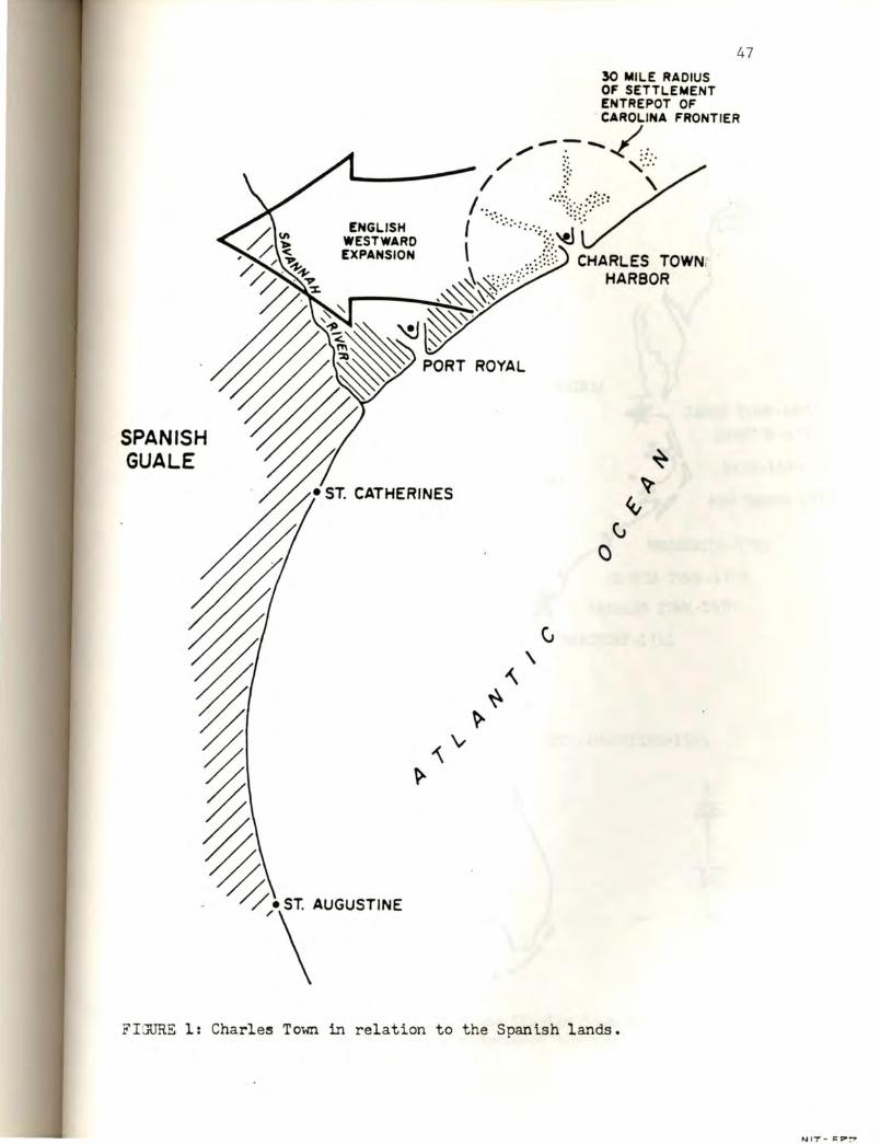
SPANISH GU ALE
ENGLISH
• ST. CATHERINES
FIJURE l· Ch . arles Town in relation t o the s . pan1sh land
47
s.

I ,..,,, ~-- '_____,.,/ ~--J_ ___ _
48
JA!-lliS TOWN-1607 EDENT{)N-1718
BATH-1690
NEW BERNE-1710
BRUNSWICK-1.725
GEORGE TOWN-1729
CHARLES TOWN-1~70
BEAU:i'ORT-1711
ST. AUGUSTINE-1565
* t N
+
FIGURE 2: Infilling between James Town and Charles Town and expansion of the competitive boundary throu gh Geor gia.

'e . ' . ·,,:
't
, ( .
. ' ', ·. "P
I \0 . f.l \~' , .
.'·>1 ' (! · ."': ·
( .'-" ·"' . ~ - ·. ,;, ' . ',r',, "!'· . . . ' (! '
'\ '·
'•' p · ,;
. '. ~ -- · .18 -~ .... . ,, '· . . . ~ • '$ .. - ~ ! - ~ ·· • •• ~ -•• · -.,,, · • ' ·~ .... •
,.,.- ' ·1: .· . ·-11 .· ~,, -~ --~ . · ,; _ -~"' .. ~ ', ·. . " . . . . .
I , fi ;I • . ., • . .11 • , ·-~ · ,. . .'f ·e . ~ .. · .. -~
. .. ~. . . . .; • ' . ,;I • ,11~ t>: ~ . . ... ,, • . . <#I ' JI . < ,::'" . .
. ~ - ' ~ ... ~ :!/ /"..., . ' 6
·-~ .~ ~ .... . .., :a"c.
·, ·.,· ." .. ,., ·. ~ ' • ' f" ~ '"; ~- . . ' -.,?;~ ·· ~ . "< ~ ...... ~ ...,.
"- ~ .... ~~ ~ ,.,.. "'\ ~ ~ .~~ . ~ .
·.p . ti' f . ~ -
..... .J. ..... .
' .}" ...
·f
" ,,, . ~ ~
.
· .. Ii
/I
Ji)
·. ,

A Mad .bt1ll1 !IIDRI&
A Mr. Norman 3110R93
Morrla 311CH679
so
FIJURS 4: Seventeenth-century s ites l ocated in the Ashl ey River survey.

FLORIDA
~1l,o.1,,,ro1u~ . · I I
SA )l 't' A. "Et..£ a,1 A,
- SpA1.N' ....
• STAucus-r1~J! ,.., SpAt~-
~ t N +
FIGURE 5: Initial En glish attempts to colonize, circa 1585. The "Lost Colony11 •

/ rf_
GU ALE
PORT R'.)YAL
- 30° - --r--..ik- ST . AUGUSTINE
2. MASSACHUSETTS COLONY, 1520, F OLLOWED BY INF ILL IN J AN!J EXPANSION.
l. INITIAL ENJLISH ATT2M?TS FA IL, 1580-1590 , FOLLOWZD BY SUCCESS AT JA1'1ES Ta.,m IN 1607.
) . CHARLES TOWN COLONY, 1~70, FOLLOWED BY IlffILLING AND EXPANSION.
t N
FIGURE 6: Stages of the English model.

53
the boundary. The width and changes in extent of the zone through time
should be examined with archaeological techniques to determine its nature
and use. Sites on this boundary during the English period should contain
materials of Spanish origin that reflect raiding behaviors into Spanish
territory. In addition to secular goods in this inventory, there should
be religious materials from attacks on Spanish missions. Materials
resulting from trade with populations in the Spanish territories will
also be present.
Within the fabric of military capability, the residents of the
colony would have become involved in the production of livestock, naval
stores and subsistence crops. Since certain members of the population
most involved in these behaviors may only be visible in the
archaeological record, (and missing in documents), research designs for
the discernment of seventeenth-century Blacks, Indian slaves, and poor
Whites should be created to locate sites pertinent to thejr behaviors.
Although the deep water-high ground nexus is an important predictive
tool for locating and examining certain aspects of the colony, focusing
too heavily on this model will bias the archaeological data return toward
the activities of upper-class members of the society and economic
activities centering on the river systems of communication. This nexus
may be used as a point of departure for the systematic location and
examination of other areas of activity away from high ground and deep
water.
On a fluctuating boundary such as existed in the Edisto
Port-Royal-Savannah area it is expected that archaeological remains will
reflect interrupted occupations, multiple components, and successive
occupations of the same site by various representative of the cultural

mix present in th i s zone during the period of disruption. This
instability and fluctuation should be visible within the whole zone of
the boundary.
54
The successful establishment of such a boundary by the English to
protect Carolina lands not yet populated by colonists should have
permitted an infilling of the area between Virginia and Charles Town.
This process of infilling should be visible in the archaeological record,
and the establishment of the North Carolina towns for Bath (1690), New
Berne (1710 ) and Brunswick ( 17 25) indicates that this is, in fact, the
case (Powel l 1968:26,348,66). A colony on a competitive frontier
stimu lates settlement expansion well beyond its immediate confines .
The English Model
The historiographic construction provides useful data for extending
consideration to other areas of English colonization on the North
American continent . After examining the structure of Carolina as a
competitive boundary on t he southern extent of English colonial activity,
it can be hypothesized that a similar boundary should hav e existed on the
northern extremity of English colonial activity as well.
On returning to the strategic model of colonization presented by
Hakluyt (1584) one finds that the northern boundary of English
colonization was set at Cape Briton (47 degrees North latitude ) . Initial
English colonizing attempts focused on the coast in the neighborhood of
36 degrees North latitude to 37 degrees North latitude, somewhat south of
the center of the proposed range. Two distinct attempts in seven
expeditions failed to establish a colony on the coast of North Carolina
at 36 degrees North latitude in the decade of 1580-1590 (Humber 1962 )
(Figure 5). The English were eventually successful in securing a

55
foothold at this approximate latitude in 1607, establishing Jamestown at
37 degrees North latitude on the more suitable Virginia riverine system
(Cotter and Hudson 1957) .
At approximately the same date, (1608), the French established
Quebec colony near 46 degrees North latitude. In 1620, the Massachusetts
colony, at 42 degrees North latitude, provided a competitive boundary
between the English and the French in the area of Maine, outstripping and
absorbing the 1618 Dutch colony of New Amsterdam. In this competition
both the English and the French made large overlapping claims (McNeil
1967:304-305; Meinig 1985).
Massachusetts, 5 degrees north of Jamestown, provides the northern
boundary of the region of seventeenth-century English activity. The 1670
establishment of Carolina and the contested Port Royal-Savannah area
approximately 5 degrees south of Jamestown forms the southern boundary.
Therefore, the English Model can be stated: The English procedure
was to establish a colony to provide an occupation of the center, extend
a flanking colony to the north and secure the boundary followed by
extending a flanking colony to the south and securing the boundary. A
dual process of infilling between the boundaries and the center coupled
with outward expansion of the boundaries then followed (Figure 6).
If the preceding construction is correct, Jamestown formed the
pivotal center of English colonization, and 1620 Massachusetts and 1670
Carolina anchored the right and left wings as flanking bulwark colonies.
In this context Massachusetts should provide a data base to compare
against the Carolina data to address questions of colonial expansion on a
competitive boundary .

56
This extends the anthropological and archaeological implications of
Charles Town and Carolina beyond those of particularistic and local
interest, to a consideration of broad patterns of English colonial
strategy. Knowledge of this level of English activity may then be
applied to comparative examinations of successful and unsuccessful
strategies of other nations who competed for territories in the New
World.
Other Pertinent Models
A necessary step remaining in these considerations is a comparison
of these historiographically derived models with other proposals form the
field of archaeology designed to address frontier expansion in Carolina
on a general level.
Recently, Kenneth Lewis (1984) has presented a model of frontier
expansion based on archaeological data from colonial South Carolina. The
study explores processes of frontier change in complex societies,
concentrating specifically on the relationship of such processes to the
broader expanding system containing the colonizing society (Lewis
1984:1). The study focuses on the evolution of intrusive groups which,
according to the author, offer the advantages of having documentary
records that can be used to establish a baseline, and of exhibiting
processes of rapid adaptation (Lewis 1984:2).
Lewis constructs a general model designed to define the nature of
processes, identify common characteristics of colonial activity, and
reconstruct past processes of change. The model is said to be
"necessarily" economic and must deal with change resulting from the
expansion of an intrusive society into a new territory over a period of
time, using the region as a frame of reference (Lewis 1984:2-3, italics
57
added). A major task of the study is to construct and examine a
comparative model of frontier change resulting from overseas expansion of
a complex society intent on permanent agricultural colonization (Lewis
1984:5).
Lewis elaborates on the concepts of "insular frontier" and
"agricultural frontier".
Insular frontier settlement is essentially a process of agricultural expansion associated with overseas colonization in a world economy. Its existence is a result of the deliberate movement by foreign colonists into a new area to use its resources to produce commercial crops and other commodities. Because of the permanent nature of agricultural settlement, the insular frontier process involves long-term occupation and growth which require an increasingly complex level of organization. Emphasis on the production of commercial exports and the development of an internal economy are the key elements inherent in insular frontier settlement (Lewis 1984:19).
Lewis states further that the process of expansion is a general
phenomenon associated with long-te~m agricultural colonization (Lewis
1984:24).
Briefly summarized, the "agricultural frontier" operates in this
manner, according to Lewis. Increases in demand for an agricultural
commodity permits the distance at which a crop can be profitably grown to
be increased, producing a larger total agricultural supply area. If
coupled with advances in transport technology which reduce costs imposed
by distance, crop zones expand as volume of supply increases (Lewis
1984:20). This expansion is keyed to increasing demand for frontier
products from previously settled areas. If these demands regularly
exceed agricultural output, sustained colonization will result (Lewis
1984:20-21).
Lewis presents an additional concept--Cosmopolitan Frontier change
(Lewis 1984:264-292). Cosmopolitan Frontiers are characterized by

58
specialized, extractive economic activities in peripheral areas of the
world economy. The limited nature of these frontiers make them
short-term and impermanent with close economic ties to the homeland. As
a result the model predicts an absence of insularity found in frontiers
characterized by permanent settlement (Lewis 1984:264). Success of the
Cosmopolitan Frontier is dependent soley on the ability to produce a
marketable commodity for export to a settled region. The specialized
nature of this frontier requires that it "heavily" depends on outside
support and attempts need not be made to establish a subsistence base in
the colony (Lewis 1984:265; italics added). It is characteristic of the
cosmopolitan model that colonists reside there only as wealth seekers or
agents of state institutions (Lewis 1984:18).
Lewis then moves to the establishment of South Carolina as a data
base, stating that the existence of insular frontier processes
may be observed on the Eastern Seaboard by studying South Carolina as a more-or-less typical example of British colonization (Lewis 1984:32).
Lewis establishes South Carolina as an insular frontier, saying,
Initially, south Carolina was established as a permanent settlement to be sustained by the production of export staples. In these respects, the colonization of South Carolina was already typical of insular frontier settlement. The remaining attributes of this type of colonization: the production of staples, local reinvestment of capital and the development of a distinct colonial society, would appear later as the colony evolved over the next century (Lewis 1984:37; italics added).
There are some basic problems in applying Lewis's model to the whole
period of frontier expansion in South Carolina, which Lewis feels one
should be able to do.
Lewis assumes that South Carolina is typical of British colonization
on the Eastern Seaboard, whereas a historiography of the colony indicates

59
that it was one of two flanking bulwarks of the entire scope of English
colonial enterprise. Rather than being ''typical'', the colony provided a
fortified boundary behind which an infilling process could take place on
the Seaboard.
Additionally, although South Carolina is insular in terms of Lewis'
definition, the model cannot address the activities of the seventeenth
century because they do not rest on the agricultural production of export
commodities. The commodities produced for export were instead those
which Lewis categorically assigns to the model of exploitation by
impermanent intrusion, the Cosmopolitan model (Lewis 1984:16-18,
263-292).
The Charles Town colony of the seventeenth century cannot be fully
comprehended by or forced into either model, creating a theoretical
dilemma which Lewis resolves by applying the insular model of frontier
expansion primarily to post-1731 conditions (Lewis 1984:51). Although
strategic considerations of the seventeenth century are alluded to in
passing (Lewis 1984:46) and the formation of trade routes cited as the
foundation for the post-1731 expansion of the colony (Lewis
1984:50-51,53), this model is not able to account for or explain the
primary processes of frontier expansion in seventeenth-century South
Carolina. Additionally, the model is not able to address the
seventeenth-century economic base of the colony.
In the context of the present discussion, Lewis' model helps to
explain the post-1731 infilling process. This took place after the
successful securing of the lower South Carolina boundary, a 1721 movement
of the buffer into the Guale-Georgia area, which was in turn followed by
the formation of the Oglethorpe colony in 1733. While the model does

60
address aspects of frontier expansion it does not possess the
comprehensive level of general application through the whole period of
colonial intrusion as Lewis proposes.
The model's narrow applicability is lessened if it is not bound to
production of an agricultural staple but is allowed to includ~ the use of
other types of staple commodities by an insular colony. This would allow
the model to consider seventeenth-century activities of the South
Carolina insular colony and to address the use of indigenous populations
by permanent settlers.
Other tools available for considering Carolina archaeological data
are the methods of quantification and pattern recognition developed by
Stanley South (1977). The application of these methods allows the
comparison of data derived from archaeological contexts across space and
time. Additionally, South has derived a formula for dating and
identifying periods of occupation through the use of ceramic types (South
1977:201-271). These methods greatly increase the capabilities of
archaeologists to address English archaeological sites in the Carolinas
and on the Eastern Seaboard.
Leland Ferguson has been working with colonoware found on southern
colonial sites from the perspective that these wares were produced by
Black people living in a colonial plantation environment (Ferguson 1978).
This work is improving archaeologist's capability of using the
archaeological record to learn about this important but little understood
group.
The work of many prehistoric archaeologists focusing on Southeastern
Indian groups provides a baseline for the consideration of these peoples
during the time of contact. The complex period of contact provides a

61
fertile f i eld for stud y of these processes in the South and elsewhere.
More work is needed in this area, following the example set at University
of North Carolina excavations in Hillsborough, N.C. on a ca. 1700 Indian
village (Dickens, Ward & Davis 1984; 1985).

CHAPTER V
SUMMARY
Archaeology, within American Anthropology, has recently begun to
consider literate, historic cultures. There has, however, been a lag in
the joining of archaeology with anthropological use of documentary data
from historic contexts . Although some archaeologists are exploring the
use of documentation as cultural data, others contend that the use of
documentation does not change the results of archaeological study.
The central theme of this thesis is that an analytical combination
of written communications originating within a literate society with a
study of the archaeological remains of that society can increase the
understanding of both data bases. An increase in the understanding of
the data bases leads to an increase in an understanding of the culture
being studied. This is accomplished by using both types of data in a
complementary way to create a culture context, or historiography. The
historiography can be used to derive anthropological interpretations.
I have illustrated this by combining primary documentation relating
to the processes of English sixteenth-eighteenth century colonization and
archaeological evidence of these processes observed on the Carolina
landscape.
I have argued in this thesis that the English consciously planned
their entry into New World colonization by formulating policy statements
of intention, method, and process at the highest English political
levels . The Elizabethan documentation cited in this thesis to illustrate

63
this was formulated by advisors to Queen Elizabeth and the English
Secretary of State as the nation entered into competition for the New
World. The Elizabethan plan focused English interest on the temperate
Eastern Seaboard of North America, between 30 degrees North latitude and
47 degrees North latitude.
The plan specifically elaborated on competition with the Spanish for
territory, called for the use of Indians against the Spanish, and
emphasized the development of maritime trade between England and the
potential colonies. English occupation was to be accomplished by
establishing two to three strong English forts between Florida and Cape
Briton (30 degrees North latitude to 47 degree North latitude). The
Elizabethan plan specifically described the characteristics of these
fortified colonies. They were to be located on a good harbor, and have
navigable rivers connecting with the interior to be used for trade and
expansion. The harbor should become the central port for the commodities
of a large territory and the seat of government for all the surrounding
provinces. The colony should have a temperate climate, good water, and
good soil for the development of commodities. The native peoples should
be used to gain information about the place, for trade, and for
alliances.
Since these Elizabethan plans state the specific geographical focus
of English colonial activity and formulate a specific model of behavior
relative to that area, the specificity of these plans is testable against
subsequent English colonial behavior. I have proposed the following
hypothesis for testing : Elizabethan policy makers formulated an explicit
model for English colonization of the New World. If this model was

64
implemented, examinat i on of subsequent English colonial activity on the
Eastern Seaboard of North America should reveal a closeness of fit
between actual activity on the landscape and the behavior called for in
the Elizabethan plan.
This hypothesis was tested by comparing documentary and
archaeological data from seventeenth-early -eighteenth-century Charles
Town, South Carolina with the Elizabethan plan. Through the use of
primary documentation and archaeological data I have demonstrated a close
agreement between the structure and function of the Charles Town colony
and the Elizabethan plan.
As required in the sixteenth-century plan the colony was located on
a good harbor with river communications into the interior. Charles Town
harbor became the trade center for a huge segment of Southeastern North
America and was the political center for a substantial portion of that
area, The colony met the requirements of climate, water and soil,
developing subsistence resources and agricultural commodities while
supporting itself with trade commodities. This drew ocean navigation to
the colony and its population increased.
As a heavily fortified port, Charles Town was the foundation of a
competition boundary against the Spanish along the Savannah River.
Colonists from Charles Town, in alliance with Indians, operated
militarily against the Spanish to expand English control into Georgia.
At the same time the area between Charles Town and Virginia began to fill
with colonists, protected by the South Carolina buffer. As expansion
continued into Georgia the English gained control of the southeastern
corner of North America, a major goal of the Elizabethan plan. This
i solated the Spanish in peninsular Florida and set the stage for westward

colonization through Alabama and Louisiana in competition with the
French.
65
Archaeological examination of the Charles Town colony has
demonstrated the accuracy of seventeenth-century maps as well as
providing new data. These surveys have shown a strong relationship
between desirable deep water-high ground locations and occupation by high
status individuals (South and Hartley 1980; Hartley 1984). These studies
have shown that these populations were located along the navigable river
systems radiating from the harbor. I have pointed out, however, that the
exclusive use of the deep water-high ground model for the location of
sites will skew observations toward high-status individuals. In addition
to further study of sites following this model, I have recommended their
use as a point of departure for the location and study of less visible
but systemically related poor White, Black and Indian populations.
Archaeology has also demonstrated that the competing Spanish
population is visible in material remains from Charles Town sites.
From these results I have derived the Charles Town model. This is a
general model of English competitive intrusion into the sphere of a
hostile colonial nation, abstracted from the Elizabethan plan and the
behaviors of the Charles Town colony. This model treats the use of such
a colony as a seaport, the relations of the colony with the indigenous
population, and the use of the colony in expansion against a hostile and
competing colonial nation. A number of hypotheses were proposed, based
on the historiography and the Charles Town model.
One hypothesis was that a counterpart of the southern boundary
colony should exist on a northern range of proposed English activity.
This was tested through a further examination of historical data, which

66
showed that the first colony of Jamestown (1607) established the center
of the zone of English activity, followed by the establishment of
Massachusetts to the north in 1620. This created a northern competitive
boundary against the French in the area of Maine. This boundary is a
potential source of data to test the generality of the Char].es Town
model.
I have proposed the English model as a statement of these broad
processes on the Eastern Seaboard of North America, which states: The
English colonial procedure in North America was to establish a colony at
the center of the proposed range of activity (Jamestown), extend a
competitive boundary to the north (Massachusetts) and secure it. This
was followed by extending a second boundary to the south (Charles Town )
and securing it. The establishment of the center colony and the two
flanking boundary colonies allowed a dual process of (1) infilling
between the boundaries and the center, and (2) continued expansion of the
boundaries outward. In this process of frontier expansion the English
gained control of the zone established as a goal in the Elizabethan
policy statements. This control of the Eastern Seaboard laid the
foundation for a westward movement across the North American continent.
I have compared these models with a recent model of frontier
expansion proposed by Kenneth Lewis (1984) from South Carolina data.
Lewis's model assumes that frontier expansion is based on increasing
demand for colonially produced agricultural staples in the homeland and
previously settled areas (Lewis 1984:19-20). The "insular frontier"
concept is bound to the "agricultural frontier" and is defined by Lewis
as the deliberate and permanent movement of foreign colonists into a new
area to produce commercial crops. According to this model, it is the

67
permanent nature of agricultural settlement which produces long-term
occupation and growth, requiring an increasingly complex level of
organization. Lewis contends that emphasis on the production of
commercial exports and the development of an internal economy are the key
elements in insular frontier settlement (Lewis 1984 : 2-5;20-25).
Lewis contends that a model of colonization must deal with change
resulting from the expansion of an intrusive society into a new territory
over a period of time (Lewis 1984 : 3) .
Lewis assumes that South Carolina is typical of British colonization
on the Eastern Seaboard (Lewis 1984:32), whereas a historiography of the
colony indicates that it was one of two flanking bulwarks of the entire
scope of English colonial enterprise. Rather than being "typical", the
colony provided a fortified boundary behind which an infilling process
could take place on the Seaboard .
Additionally, although seventeenth-century South Carolina had basic
elements of "insularity" in terms of Lewis' definition (Lewis 1984:37),
the model cannot address important processes of frontier expansion in
seventeenth-century South Carolina because they do not rest on the
agricultural production of an export commodity. The commodities produced
• for export in that time were those which Lewis categorically assigns to a
model of impermanent intrusion, called the Cosmopolitan model (Lewis
1984:16-18,163-292). This model does not address expanding permanent
settlement behind a military frontier, sustained by subsistence
agriculture, although this was an important pattern in
seventeenth-century South Carolina (Proprietors 1669:125-127; West
1671:267; Wilson 1682:27-28). Lewis primarily applies this model to
68
post-1731 conditions (Lewis 1984:51) and it helps explain certain
infilling processes behind a militarily expanded frontier.
In conclusion, I have proposed that a combination of documentation
and archaeological data is suitable for the application of the
hypothetico-deductive method in addressing anthropological questions.
This thesis has illustrated this. In accomplishing this task, insights
have been gained concerning processes of English colonization on the
Eastern Seaboard of North America. These perceptions occur on a number
of levels, from the activities of a particular colony to the broad range
of English activity on the Seaboard. These processes are also seen to
have durability across time. They were observed as untested proposals of
processual behavior and were subsequently observed being successfully
continued a generation later. The far-reaching scope of these processes
can be seen in the structure of the present day United States. This
nation lies, basically, between the limits of English colonial activity
proposed by the Elizabethans, 30 degrees North latitude and 47 degrees
North latitude. The first frontier was the shoreline of the East Coast,
but the declared western limits were the extent of the continent, and
this to was accomplished.
Oh! let our voice his praise exalt, Till it arrive at heaven's vault, Which, thence (perhaps) rebounding, may Echo beyond the Mexique Bay
Thus sung they, in the English boat, A holy and a cheerful note, And all t~e way, to guide their chime, With falling ears they kept the time.
from BERMUDAS
(Andrew Marvell 1621-1678) (Shafer 1944)

REFERENCES CITED
Bigges, Walter 1589 A Summarie and True Discourse of Sir Francis Drakes West Indian
Voyage. In Sir Francis Drake's West Indian Voyage 1585-86, [1981), edited by Mary Frear Keeker. The Hakluyt Society, London.
Boston News 1715 An Account of the Breaking out of the Yamassee War in South
Carolina. In Historical Collections of South Carolina, vol. II, [1836), edited by~ R. Carroll. Harper & Row Brothers, New York.
Bull, Stephen 1670 Letter, Bull to Lord Ashley. In Collections of the
South Carolina Historical Society, vol. V, [1897_]_,_
Carolina 1706
edited by Langdon Cheves, Charleston.
Account of the Invasion Made by the French and Spaniards Upon Carolina. In Records In The British Public Record Office Relating to So~h~rolina 1701-1710,
[1947), edited by A. S. Salley, Jr. The Historical Commission of South Carolina, Columbia.
Carolina Council 1670b Letter, Council to The Lords -Proprietors. In Collections
of The South Carolina Historical Society, vol. V,
Carolina 167la
167lb
[1897), edited by Langdon Cheves, Charleston.
Council Journal Minutes, September 5th. In Collections of The South Carolina Historical Society, vol. V, [1897)~dited by Langdon Cheves, Charleston.
Minutes, October 2nd. In Collections of The South Carolina Historical Society, vol. V, [1897), edited by Langdon Cheves, Charleston.
Carroll, B.R. 1836 Historical Collections of South Carolina, -edited by
B. R. Carroll. Harper ~Brothers, New York.

Carteret, Nicholas 1670 Mr. Carteret's Relation. In Collections of The South
Carolina Historical Society, vol. V, [18971",~ited by Langdon Cheves, Charleston.
Charles I 1629
Charles II 1663
Sir Robert Heath's Patent. In Collections of The South Carolina Historical Society, vol. V, [1897)-,-edited by Langdon Cheves, Charleston.
The First Carolina Charter. In Collections of The South Carolina Historical Society, vol. V, [189~ edited by Langdon Cheves, Charleston.
Cheves, Langdon, Esq. ed.
70
1897 The Shaftesbury Papers and Other Records Relating to Carolina. Collections of The South Carolina Historical Society, vol. V, Charleston.
Coe, Joffre L. 1964 The Formative Cultures of the Carolina Piedmont. Transactions
of the American Philosophical Society, 54(5), Philadelphia.
Connor, Jeanette T. 1925 Colonial Records of Spanish Florida: Letters and Reports of
Governors and Secular Persons, translated and edited by J.T.C. Florida State Historical Society Publication, No. 5, vol. 2, Deland, Florida.
Cotter, John L., and J. Paul Hudson 1957 New Discoveries at Jamestown. U. S. Government Printing
Office, Washington, D.C.
Council 1606
for Voyage to Virginia Instructions for the Virginia Colony of 1606. In The Original Writings and Correspondence of the Two Richard Hakluyts, vol. II, [1935), edited by E.G.R. Taylor, D. Sc. The Hakluyt Society, London.
Crane, Verner W. 1981 The Southern Frontier 1670-1732. W.W. Norton &
Company, New York, London.
Crumley, 1974
Carole E. Celtic Social Structure: The Generation of Archaeologically Testable Hypotheses from Literary Evidence. Anthropological Papers, Museum of Anthropology, No. 54, Ann Arbor.

Cumming, 1962
Dalton, 1670
William P. The Southeast in Early Maps With An Annotated Check List of Printed and Manuscript Regional and Local Maps of Southeastern North America During the Colonial Period. University of North Carolina Press, Chapel Hill.
Joseph Letter, Dalton to Lord Ashley. In Collections of the South Carolina Historical Society, vol. V, [1897J,~edited by Langdon Cheves, Charleston.
DePratter, Chester B., and Marvin T. Smith
71
1980 Sixteenth Century European Trade in the Southeastern United States: Evidence from the Juan Pardo Expeditions (1566-1568). In Spanish Colonial Frontier Research, edited by Henry F. Dobyns. Center for Anthropological Studies, Albuquerque, New Mexico.
Dickens, Roy S., Jr., H. Trawick Ward, and R.P. Stephen Davis Jr. 1984 The Historic Occaneechi: An Archaeological Investigation of
Culture Change [1985].
Henry F. Dobyns, 1980 The Study of Spanish Colonial Frontier Institutions. In
Spanish Colonial Frontier Research, edited by Henry F. Dobyns. Center for Anthropological Studies, Albuquerque, New Mexico.
Dorrell, 1670
John Sr., and Hugh Wentworth Letter, from Dorrell and Wentworth to Lord Ashley. Collections of the South Carolina Historical Society, vol-.-V-,~[1897], edited by Langdon Cheves, Charleston.
Ferguson, Leland G.
In
1978 Looking for the "Afro-" in Colona-Indian Pottery. The Conference on Historic Site Archaeology Papers, 12: 68-86. Institute of Archeology and Anthropology, University of South Carolina, Columbia.
Florio, J. 1580 Dedication of Floria's Cartier. In The Original
Writings~ Correspondence of the Two Richard Hakluyts, vol. I, [1935], edited by E.G.R. Taylor, The Hakluyt Society, London.
Gannon, Michael V.
D. Sc.
1965 The Cross in the Sand. University of Florida Press, Gainesville.

72
Hakluyt, Richard 1578 Notes on Colonization. In The Original Writings_!
Correspondence of the Two Richard Hakluyts, vol. I, [1935), edited by E.G.R. Taylor, D. Sc. The Hakluyt Society, London.
1582 Diverse Voyages to America. Hakluyt Society Publication 7. The Hakluyt Society, London.
1584 Discourse of Western Planting. In The Original Writings _! Correspondence of the Two Richard Hakluyts, vol. II, [1935), edited by E.G.R. Taylor, D. Sc. The Hakluyt Society, London.
Haley, K.H.D. 1968 The First Earl of Shaftesbury. Clarendon Press,
Oxford, England.
Hartley, 1984
Michael 0. The Ashley River: A Survey of Seventeenth Century Sites. Institute of Archeology and Anthropology Research Manuscript Series 192. University of South Carolina, Columbia.
Hilton, William 1663 A True Relation of a Voyage. In Collections of The
South Carolina Historical Society, vol. V, [1897-)-,edited by Langdon Cheves, Charleston.
Hoffman, Paul E. 1983 Legend, Religious Idealism, and Colonies: The Point of Santa
Elena In History, 1552-1566. In South Carolina Historical Magazine, vol. 84, No. 2. South Carolina Historical Society, Charleston.
Honigmann, John J. 1976 The Development of Anthropological Ideas. The Dorsey
Press, Homewood, Illinois.
Humber, John Leslie
1962
J.C.I.T. 1712
1713
Backgrounds of the Roanoke Voyages. Unpublished Master's Thesis, Department of History, University of North Carolina, Chapel Hill.
Journal of the Commissioners of the Indian Trade In The Colonial Records of South Carolina, [1955], edited by W.L. McDowell,-""south Carolina Archives Department, Columbia.
In The Colonial Records of South Carolina, [1955), edited by W.L. McDowell, South Carolina Archives Department, Columbia.

73
1715 In The Colonial Records of South Carolina, [1955), edited by W.L. McDowell, South Carolina Archives Department, Columbia.
Lewis, Kenneth E. 1984 The American Frontier An Archaeological Study of
Settlement Pattern and Process. Academic Press, Inc. Orlando, San Diego, San Francisco, New York, London, Toronto, Montreal, Sydney, Tokyo, Sao Paulo.
Locke, John 1669 First Set of the Constitutions for the Government of Carolina.
In Collections of the South Carolina Historical Society, vol. V-,-[1897), edited by Langdon Cheves, Charleston.
Lyon, Eugene 1984 Santa Elena: A Brief History of the Colony, (1566-1587).
Institute .2.f Archeology and Anthropology Research Manuscript Series 193. University of South Carolina, Columbia.
Mathews, Maurice 1671 Letter, Mathews to Lord Ashley. In Collections of The
South Carolina Historical Society, vol. V, [1897~~edited by Langdon Cheves, Charleston.
Mathews, Mr. 1670 Mr. Mathews Relation. In Collections of The South
Carolina Historical Society, vol. V, [189~ edited by Langdon Cheves, Charleston.
McNeill, William H. 1967 A World History. Oxford University Press, New York,
London, Toronto.
Meinig, D.W. editor [map] 1985 Northern Approaches. National Geographic Society,
Cartographic Division, Washington, D.C.
Milling, Chapman J. 1940 Red Carolinians. The University of South Carolina Press,
Columbia.
Nairne, Thomas 1708 Letter, Nairne to the Proprietors. In Records In The
British Public Record Office Relating to South Carolina 1701-1710, [1947), edited by A. S. Salley, Jr. The Historical Commission of South Carolina, Columbia, South Carolina.

Owen, William 1670 Letter, Owen to Lord Ashley. In Collections of the
South Carolina Historical Society, vol. V, (1897_]_,_ edited by Langdon Cheves, Charleston.
Parker, Mattie Erma Edwards, editor 1963 North Carolina Charters and Constitutions. Carolina
Charter Tercentenary Commission, Raleigh.
Powell, William S. 1968 The North Carolina Gazetteer. The University of North
Carolina Press, Chapel Hill.
Proprietors
74
1669a Articles of Agreement Between the Proprietors of Carolina. In Collections of the South Carolina Historical Society, vol-.-V-,-(1897], edited by Langdon Cheves, Charleston.
1669b Governor Sayles Commission. In Collections of the South Carolina Historical Society, vol. V, [!897)'-;edited by Langdon Cheves, Charleston.
1669c Instructions to the Governor and Council. In Collections of the South Carolina Historical Society, vol. V, (1897], edited by Langdon Cheves, Charleston.
1669d Instructions for Mr. West About Our Plantation. In Collections of the South Carolina Histdrical . Society, vol-.-V-,-[1897], edited by Langdon Cheves, Charleston.
1669e Instructions to Joseph West, Storekeeper. In Collections .Q.f the South Carolina Historical Society, vol. V, (1897], edited by Langdon Cheves, Charleston.
Randolph, Ed . 1699 Letter, Randolph to the Commissioners for Trade and
Plantations. In Records In The British Public ---Record Office Relating to South Carolina 1701-1710, (1946], edited by A. S. Salley, Jr. The Historical Commission of South Carolina, Columbia.
Salley, A.S., Jr. 1904 Governor Joseph Morton and some of his descendants. The
South Carolina Historical and Genealogical
Salley, 1946
Magazine, vol. V, No. 2.
A.S., Jr., editor Records In The British Public Record Office Relating to~uth Carolina 1698-1700. The Historical Commission of South Carolina, Columbia.

Sandford, Robert 1666 The Port Royal Discovery . In Collections of the South
Carolina Historical Society, vol. V, [18971:'" edited by Langdon Cheves, Charleston.
Sayle, William 1670 Letter, The Council to the Proprietors. In Collections of
the South Carolina Historical Society, vol . V, [1897], edited by Langdon Cheves, Charleston.
Schuyler, Robert L. 1972 Historical and Historic Sites Archaeology as Anthropology:
Basic Definitions and Relationships . In Contemporary Archaeology, edited by Mark P. Leone, Southern Illinois University Press, Carbondale and Edwardsville .
Shafer, Robert 1944 From Beowulf to Thomas Hardy . Odyssey Press.
Shaftesbury
75
167la Letter, Shaftesbury to Sir John Yeamans. In Collections of the South Carolina Historical Society, vol. V, [1897], edited by Langdon Cheves, Charleston.
167lb Letter, Shaftesbury to Henry Woodward. In Collections of the South Carolina Historical Society, vol. V, [1897], edited by Langdon Cheves, Charleston.
1672 Letter, Shaftesbury to Joseph West. In Collections of the South Carolina Historical Society, vol. V, [1897], edited by Langdon Cheves, Charleston.
Sirmans, M. Eugene 1966 Colonial South Carolina . University of North Carolina
Press. Chapel Hill.
South, Stanley 1969 Exploratory Archeology at the Site of 1670-1680 Charles Town on
Albermarle Point in South Carolina. University of South Carolina, Institute of Archeology and Anthropology Research Manuscript Series 1. Columbia.
1977 Method and Theory in Historical Archaeology. Academic Press, New York, San Francisco, London.
1980 The Discovery of Santa Elena. Institute of Archeology and Anthropology, Research Manuscript Series 165. University of South Carolina, Columbia.
1982 Exploring Santa Elena 1981. Institute of Archeology and Anthropology, Research Manuscript Series 184. University of South Carolina, Columbia.

76
1983a Revealing Santa Elena 1982. Institute of Archeology and Anthropology, Research Manuscript Series 188. University of South Carolina, Columbia.
1983b The Chairman's Final Report for the Final Volume of The Conference On Historic Site Archaeology Papers. In The Conference on Historic Site Archaeology Papers, vol. 15, edited by Stanley South. The Institute of Archeology and Anthropolo gy , University of South Carolina, Col umbia.
1984 Testing Archeological Sampling Mehods at Fort San Felipe 1983. Institute of Archeology and Anthropology, Research Manuscript Series 190. University of South Carolina, Columbia.
South, Stanley and Michael 0. Hartley 1980 Deep Water and High Ground. Institute of Archeology
and Anthropology, Research Manuscript Series 166. Universit y of South Carolina, Columbia.
Taylor, E.G.R. 1935 The Original Writings! Correspondence of the
Taylor, 1967
Two Richard Hakluyts, vols. I & II, The Hakluyt Society, London.
Walter W. A Study Qf Archeology. Arcturus Books Edition, Southern Illinoi s University Press, Carbondale and Edwardsville.
Vassall, John 1667 Letter, John Vassall to Sir John Colliton. In Collections
of the South Carolina Historical Society, vol. V, [1897], edited by Langdon Cheves, Charleston.
Walsingham, Sir Francis 1583 Letter, From Sir Francis Walsingham to Richard Hakluyt. In
The Original Writings! Correspondence of the Two Richard Hakluyts, vols. I, [1935], edited by E.G.R. Taylor, D. Sc. The Hakluyt Society , London.
West, Joseph 1669 Letter, Joseph West to Lord Ashley Cooper. In Collections
of the South Carolina Historical Society, vol. V, TT897], edited by Langdon Cheves, Charleston ..
1671 Letter, West to Lord Ashley. In Collections of the South Carolina Historical Society, vol. V, [1897_]_,_ edited by Langdon Cheves, Charleston.
Whitehall 1669 Warrant to the Commissioners of Ordnance. In Collections
of the South Carolina Historical Society, vol. V, Tf897}, edited by Langdon Cheves, Charleston.
Wil son, Samuel 1682 An Account of the Province of Carolina in America. In
Historical Collections of South Carolina, vol. II,
77
[1836], edited by B.R. Carroll . Harper & Brothers, New York .
Woodward, 1670
1674
Henry Letter, Woodward to Sir John Yeamans . In Collections of the South Carolina Historical Society, vol. V, [1897], edited by Langdon Cheves, Charleston.
Letter, Woodward to Lord Ashley. In Collections of the South Carolina Historical Society, vol. V, [1897], edited by Langdon Cheves, Charleston .
Yeamans, William 1664 The Barbadoes Concessions.
Carolina Historical Society, Langdon Cheves, Charleston.
Yonge, Francis
In Collections of the South vol. V, [1897]-,-edited by
1720 A Narrative of the Proceedings of the People of South Carolina in the Year 1719. In Historical Collections of South Carolina, vol . II, [1836], edited by B.R. Carroll, Harper & Brothers, New York.