Embed Size (px)
Citation preview
1 | US DOE Geothermal Office eere.energy.gov
Public Service of Colorado Ponnequin Wind Farm
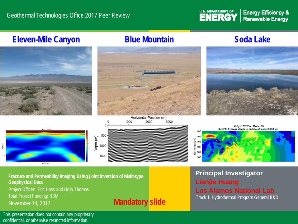
Geothermal Technologies Office 2017 Peer Review
Fracture and Permeability Imaging Using Joint Inversion of Multi-type Geophysical Data
Principal InvestigatorLianjie HuangLos Alamos National LabTrack 1: Hydrothermal Program General R&D
Project Officer: Eric Hass and Holly ThomasTotal Project Funding: $3MNovember 14, 2017
This presentation does not contain any proprietary confidential, or otherwise restricted information.
Mandatory slide
Eleven-Mile Canyon Blue Mountain Soda Lake

2 | US DOE Geothermal Office eere.energy.gov
Relevance to Industry Needs and GTO Objectives
• Challenge: Reliable imaging of fractures and permeability is one of the biggest challenges in hydrothermal exploration and development.
• Impact: Successful fracture and permeability imaging will reduce the exploration risk, and lower overall costs for geothermal power projects.
• Innovative aspects:– Anisotropic full-waveform seismic inversion and imaging, rather than
using isotropic techniques, to greatly improve reliability and resolution of fracture/fault imaging
– “Virtual Seismometers” allow us to focus on the microseismically active zone to improve accuracy of microseismic imaging
Mandatory- may utilize multiple slides

3 | US DOE Geothermal Office eere.energy.gov
Relevance to Industry Needs and GTO Objectives
• Innovative aspects:– Analysis of scattered seismic waves of microseismic data to improve
fracture characterization– Joint ZTEM/MT and constrained MT to greatly improve resolution of
resistivity– Joint inversion/cooperative interpretation of multi-type geophysical
datasets to minimize the uncertainty of individual data analysis and optimize fracture and permeability imaging
• Impact on the following GTO’s goals:– “Improving processes of identifying, accessing, and developing
geothermal resources” and– “Overcoming technical obstacles and mitigating risk”
Mandatory- may utilize multiple slides

4 | US DOE Geothermal Office eere.energy.gov
Methods/Approach
Mandatory- may utilize multiple slides
• To image and characterize fracture zones and map the spatial distribution of permeability using multi-type geophysical data

5 | US DOE Geothermal Office eere.energy.gov
Methods/Approach
Mandatory- may utilize multiple slides
• LANL: Developed, implemented, and validated anisotropic full‐waveform inversion and anisotropic reverse‐time migration methods; verified the methods using seven 2D lines of seismic data from Blue Mountain, and five 2D lines of seismic data from Eleven‐Mile Canyon.
• LLNL: Performed seismic interferometry of active and passive seismic data at Blue Mountain and Soda Lake; Located microseismic events at Blue Mountain; Performed “Virtual Seismometers” study to focus on the microseismicallyactive zone.
• MIT: Located microearthquakes using a 3D model derived from anisotropic FWI inversion of seven 2D seismic lines from Blue Mountain
• University of Utah: Verified successful joint inversion of ZTEM/MT data from Eleven‐Mile Canyon
• AltaRock Energy, Inc. and Navy Geothermal Program Office: Interpreted initial results of active seismic imaging, passive seismic imaging, and joint ZTEM/MT imaging.

6 | US DOE Geothermal Office eere.energy.gov
Technical Accomplishments and Progress
Mandatory- may utilize multiple slides
Original Planned Milestone/ Technical Accomplishment
Actual Milestone/Technical Accomplishment
Date Completed
Verify using 2D field data that LANL’s new anisotropic seismic inversion can reduce 25% of data misfit
Verified using 2D field data from Blue Mountain and Eleven-Mile Canyon that LANL’s new anisotropic seismic inversion can reduce more than 30% of data misfit
September,2016
Verify using 2D field data that our new anisotropic reverse-time migration imaging can detect fracture zones
Verified using 2D field data from Blue Mountain and Eleven-Mile Canyon that our new anisotropic reverse-time migration imaging can detect fracture zones
September,2017
Produce a 3D seismic model (Vp, Vs and Q) of the Blue Mountain and Soda Lake sites using active and passiveseismic data.
Done using ambient noise correlation and active source interferometry combining historical seismic survey with current monitoring array data.
March, 2017

7 | US DOE Geothermal Office eere.energy.gov
Technical Accomplishments and Progress
Mandatory- may utilize multiple slides
Original Planned Milestone/ Technical Accomplishment
Actual Milestone/Technical Accomplishment
Date Completed
Complete development of VSM moment tensor inversion algorithm
Done and tested on synthetic data. August, 2017
Catalog, locate and estimate slip on Blue Mountain microseismicity
Done using matched field and VSM on data from AltaRock’s current monitoring network. Continuing as new data arrive
September,2017, and on-going
Develop 3D Joint MT/ZTEM Inversion Developed 3D Joint MT/ZTEM Inversion
June, 2016
Locate microseismic events at Blue Mountain
Located microseismic events at Blue Mountain
September, 2017
3D Joint Inversion of 11 Mi Cyn Data 3D Joint Inversion of 11 Mi Cyn Data June, 20173D MT Inversion of Soda Lake 3D MT Inversion of Soda Lake June, 20163D MT Inversion of Blue Mountain 3D MT Inversion of Blue Mountain June, 2017

8 | US DOE Geothermal Office eere.energy.gov
Technical Accomplishments and Progress
Mandatory- may utilize multiple slides
Anisotropic seismic inversion of 2D seismic data from Eleven-Mile Canyon. Data misfit reduction: 31.5%.
Build anisotropic models for anisotropic migration imaging
Anisotropic seismic inversion of 2D seismic data from Blue Mountain. Data misfit reduction: 30.4%.

9 | US DOE Geothermal Office eere.energy.gov
Technical Accomplishments and Progress
Mandatory- may utilize multiple slides

10 | US DOE Geothermal Office eere.energy.gov
Technical Accomplishments and Progress
Mandatory- may utilize multiple slides

11 | US DOE Geothermal Office eere.energy.gov
Technical Accomplishments and Progress
Mandatory- may utilize multiple slides
Optim’s migration image
LANL’s migration image

12 | US DOE Geothermal Office eere.energy.gov
Virtual Seismograms at Blue Mountain
0 sec.
4 min.
4 days
5 days
10 days
Above: the evolution of the VSM envelopes over time suggests an evolving pressure field.
0 5 10 15 20 25
0 5 10 15 20 25
Z
0 5 10 15 20 25
0 5 10 15 20 25
Z
NN24 0.341.24
NM22 0.42180.00
NB04 0.72350.13
NM06 0.86124.81
NN18 1.1030.03
NB18 1.1127.95
NB19 1.18170.70
NN19 1.20172.27
NB17 1.59232.84
NN21 1.6173.19
NN17 1.75238.54
NN09 1.96283.69
NM41 2.49144.99
NM40 2.64116.68
NM03 2.6511.78
NB01 2.81333.61
NN07 2.81332.50
NM08 3.17171.11
NN32 3.17208.12
NB08 3.18171.21
NB13 3.34253.57
NM42 3.3945.00
0 5 10 15 20 25
0 5 10 15 20 25
Z
0 5 10 15 20 25
0 5 10 15 20 25
X
0 5 10 15 20 25
0 5 10 15 20 25
X
0 5 10 15 20 25
0 5 10 15 20 25
Y
0 5 10 15 20 25
0 5 10 15 20 25
Y
Synthetics calculated using the MT estimate (red) match the originally recorded waveforms (black).
VSM fast, waveform inversion of direct inversion of microseismic Moment Tensors.
(Above) Attenuation tomography at Blue Mountain(Right) thermal cross-section from Melosh et al., 2008
Seismic interferometry: sharp images of Vp, Vs and attenuation
Technical Accomplishments and Progress

13 | US DOE Geothermal Office eere.energy.gov
Technical Accomplishments and Progress
Located microseismic events at Blue Mountain
Mandatory- may utilize multiple slides
Bayesian Locations with Simple Velocity Model
Horizontal Slice Through 3D Velocity Model Derived for Blue Mountain
Geothermal Site

14 | US DOE Geothermal Office eere.energy.gov
Technical Accomplishments and Progress
Mandatory- may utilize multiple slides
Eleven Mile Canyon 3D ZTEM (Only) Inversion• 2040 ZTEM stations: 20 flight profiles, 200 m sep., 100 m data
intervals 360 Hz – 30 Hz• Mesh: 117 (x) x 261 (y) x 40 (z) nodes, 13 air layers; bird heights
(62 – 179 m) included• 100 ohm-m starting model, ZTEM data error floor of 0.01, ~5
hrs/iter. on 24 core w/s• Good algorithm convergence to nRMS of ~0.5• Possible hydrothermal clay cap in west-central portion of study
area• Transition from outcrop to valley alluvium from west to east

15 | US DOE Geothermal Office eere.energy.gov
Technical Accomplishments and Progress
Mandatory- may utilize multiple slides
Eleven Mile Canyon 3D ZTEM/MT Joint Inversion• 2040 ZTEM stations: 20 flight profiles, 200 m sep., 100 m data
intervals 360 Hz – 30 Hz• Mesh: 117 (x) x 261 (y) x 40 (z) nodes, 13 air layers; bird heights
(62 – 179 m) included• 100 ohm-m starting model, ZTEM data error floor of 0.01, ~5
hrs/iter. on 24 core w/s• Good algorithm convergence to nRMS of ~0.5• Possible hydrothermal clay cap in west-central portion of study
area• Transition from outcrop to valley alluvium from west to east

16 | US DOE Geothermal Office eere.energy.gov
Research Collaboration and Technology Transfer
• AltaRock, Cyrq, and Navy Geothermal Program Office provided multi-type geophysical data, and help interpretation of results.
• The research teams met/held telecons with industry and Navy Program Office collaborators, and presented results.
• Cooperative research activities between Utah and LANL for integrating new seismic and EM imaging technology.
• LANL shared full-waveform inversion results of velocity models with the teams for microseismic imaging.
Mandatory- may utilize multiple slides

17 | US DOE Geothermal Office eere.energy.gov
Future Directions
FY18 will be focused on bringing together the different geophysical methods and multi-type geophysical data to jointly constrain the material model and image fracture properties.
– 3D anisotropic full-waveform inversion and reverse-time migration of 3D seismic data from Soda Lake.
– Use seismic imaging results to constrain MT inversion.– Determine fracture characteristics using scattered microseismic waves– Joint inversion/cooperative interpretation of multi-type geophysical datasets to
characterize fracture zones.
Mandatory-may utilize multiple slides
Milestone or Go/No-Go Status & Expected Completion Date3D seismic inversion and imaging On-going, to be complete by September, 2018Joint seismic and MT inversion On-going, to be complete by September, 2018Scattered wave analysis On-going, to be complete by September, 2018Joint inversion/cooperativeinterpretation of multi-type geophysical data
On-going, to be complete by September, 2018

18 | US DOE Geothermal Office eere.energy.gov
• Anisotropic seismic full-waveform inversion and anisotropic reverse-time migration produce clear subsurface images revealing fracture/fault zones that are invisible on industry state-of-the-art images.
• “Virtual Seismometers” allow us to focus on the microseismically active zone and improve accuracy and reliability of microseismic imaging.
• Unprecedented improvement is achieved by combining and inverting joint airborne (ZTEM) and ground (MT) EM data for resolving geothermal structures.
Mandatory Summary Slide
Mandatory- keep to one slide