Embed Size (px)
Citation preview
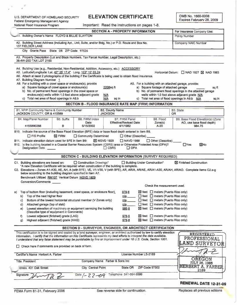
U.S. DEPARTMENT OF HOMELAND SECURITY ELEVATION CERTI Fl CATE Federal Emergency Management Agency
OMB No. 1660-0008 Exoires Februarv 28. 2009
National Flood Insurance Program Important: Read the instructions on pages 1-8.
SECTION A· PROPERTY INFORMATION For Insurance Company Use:
1. Building Owner's Name FLOYD & BILLIE SLAYTON Policy Number
A2. Buildlng Street Address (including Apt., Unit, Suite, and/or Bldg. No.) or P.O. Route and Box No. Company NAIC Number 137 FIELDER LANE
City Grants Pass State OR ZIP Code 97526
A3. Property Description (Lot and Blod< Numbers, Tax Parcel Number. Legal Desaiption. etc.) 36-4W-20D TAX LOT 2100
A4. Building Use (e.g., Residential, Non-Residential, Addition, Accessory, etc.) ACCESSORY AS. Lalilude/Longitude: Lat. 42" 25' 17.4" Long. 123° 12' 03.24 Horizontal Datum: 0 NAO 1927 1,81 NAO 1983 A6. Attach at least 2 photographs of the bulldlng if the Certificate Is being used lo obtain flood insurance. A7. Building Diagram Number 1 AB. For a bullding with a crawl space or enclosure(s), provide A9. For a building wilh an attached garage, provide:
a) Square footage of crawl space or endosure(s) 2208sq ft a) Square footage of attached garage sq ft b) No. of permanent flood openings in the crawl space or b) No. of permanent Hood openings In the attached garage
enclosure(s) walls within 1.0 foot above adjacent grade ~ walls v.1thin 1.0 foot above adjacent grade NIA c) Total net area of Hood openings In AB.b ~ sq in c) Total net area of flood openings In A9.b ~ sq In
SECTION B - FLOOD INSURANCE RATE MAP (FIRM) INFORMATION
81. NFIP Community Name & Community Number JACKSON COUNTY, OR & 415589
B2. County Name JACKSON
83. State OR
84. Map/Panel Number 85. Suffix 86. FIRM Index 87. FIRM Panel BB. Flood 89. Base Flood Elevation(s) (Zone Dale Effective/Revised Date Zone(s) AO, use base flood depth)
4155890288 B 5115/2002 4/1/1982 A-20 984.75
810. Indicate the source of the Base Flood Elevation (BFE) data or base flood depth entered in Item 89.
D FIS Profile 181 FIRM D Community Determined 0 Other (Describe) __
811. Indicate elevation datum used for BFE in Item 89: 181 NGVD 1929 D NAVO 1988 0 Other (Describe) __ 812. Is the building located in a Coastal Barrier Resources System (CBRS} area or Otherwise Protected Area (OPA)? 0Yes 181No
Designation Date __ 0 CBRS 0 OPA
SECTION C - BUILDING ELEVATION INFORMATION (SURVEY REQUIRED)
C1. Bullding elevations are based on: 0 Construction Drawings" 0 Building Under Construction" ~ Finished Construction .. A new Elevation Certilicate will be required when construction of the building is complete.
C2. Elevations-Zones A1-A30, AE, AH, A (with BFE), VE. V1-V30, V (with BFE), AR, AR/A, ARJAE, AR/A1-A30, AR/AH, ARJAO. Complete Items C2.a-g below according to the building diagram specified In Item A7.
Benchmark Utilized RM107 Vertical Datum NGVD 1929
Conversion/Comments
a) Top of bottom floor (indudlng basement, crawl space, or enclosure floor)_ b) Top of the next higher noor
c) Bottom of the lowest horizontal structural member (V Zones onfy)
d) Attached garage (top of slab)
e} Lowest elevation of machinery or equipment servicing the buildlng (Describe type of equipment in Comments)
f) Lowest adjacent (finished) grade (LAG)
g) Highest adjacent (finished) grade (HAG)
~ . .§ Dli.. __ Dli.._ al!._ ~.§
m.~
9.ZM
Check the measurement used.
~ feet D meters (Puerto Rico only)
D feet 0 meters (Puerto Rico only)
0 feet D meters (Puerto Rico only)
0 feet D meters (Puerto Rico only)
~ feet D meters (Puerto Rico only)
~ feet D meters (Puerto Rico only)
~ feet D meters (Puerto Rico only)
SECTION D - SURVEYOR, ENGINEER, OR ARCHITECT CERTIFICATION
This certification is to be signed and sealed by a land surveyor, engineer, or architect authorized by law to certify elevation information. I certify that the information on this Certificate represents my best efforts to interpf6f the data available. I understand that any false statement may be punishable by fine or imprisonment under 18 U.S. Code, Section 1001.
D Check here if comments are provided on back of form.
Certifier's Name Herbert A. Farber License Number LS-2189
Title President Company Name Farber & Sons Inc
jdress 431 Oak Street City Central Point State OR ZIP Code 97502
Signalure2A::::t4 ~ Date/- z 7 ~'( Telephone 541-664-5599
FEMA Form 81-31. February 2006 See reverse side for continuation.
RENEWAL DATE 12-31-09
Replaces all previous ediUons
r
\.
r
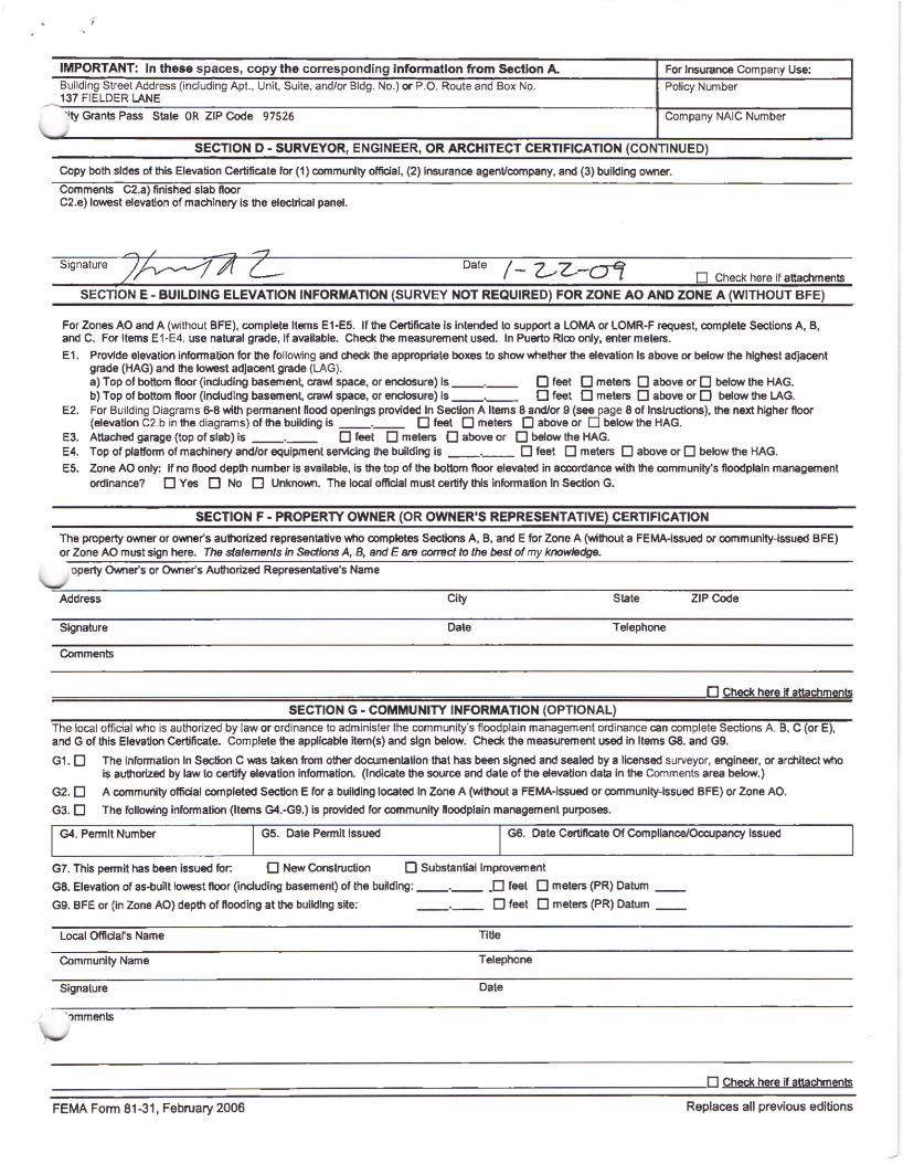
IMPORTANT: In these spaces, copy the corresponding Information from Section A. For Insurance Company Use: Building Street Address (including Apt., Unit, Suite, and/or Bldg. No.) or P.O. Route and Box No. Policy Number 137 FIELDER LANE
'~ty Grants Pass Stale OR ZIP Code 97526 Company NAIC Number J
SECTION D - SURVEYOR, ENGINEER, OR ARCHITECT CERTIFICATION (CONTINUED)
Copy both sides of this Elevation Certificate for (1) community official, (2) Insurance agenVcompany, and (3) building owner.
Comments C2.a) finished slab Hoor C2.e) lowest elevation of machinery is the electrical panel.
Signature Date /-0Z-ol D Check here if attachments
SECTION E - BUILDING ELEVATION INFORMATION (SURVEY NOT REQUIRED) FOR ZONE AO AND ZONE A (WITHOUT BFE)
For Zones AO and A (without BFE), complete Items E1-E5. If the Certificate is intended to support a LOMA or LOMR-F request, complete Sections A, B, and C. For Items E1-E4, use natural grade, if available. Check the measurement used. In Puerto Rico only, enter meters.
E 1. Provide elevation information for the following and check the appropriate boxes to show whether the elevation Is above or below the highest adjacent grade (HAG) and the lowest adjacent grade (LAG). a) Top of bottom floor (including basement, crawl space, or enciosure) Is--·-- 0 feet 0 meters 0 above or 0 below the HAG. b) Top of bottom floor (including basement, crawl space, or enclosure} is--·-- 0 feet 0 meters 0 above or D below the LAG.
E2. For Building Diagrams 6-8 with permanent Hood openings provided In Section A Items 8 and/or 9 (see page 8 of lnslructions), the next higher floor (elevation C2 .b in the diagrams) of the building is--·-- 0 feel D meters 0 above or D below the HAG.
E3. Attached garage (top of slab) is --·-- 0 feet 0 meters 0 above or D below the HAG. E4. Top of platfonn of machinery and/or equipment servicing the building is --·-- 0 feet D meters D above or D below the HAG. E5. Zone AO only: If no flood depth number is available, is the top of the bottom floor elevated in accordance with the community's floodplain management
ordinance? D Yes D No D Unknown. The local official must certify this information In Section G.
SECTION F - PROPERTY OWNER (OR OWNER'S REPRESENTATIVE) CERTIFICATION
The property owner or owner's authorized representative who completes Sections A. B. and E for Zone A (without a FEMA-issued or community-issued BFE) or Zone AO must sign here. The statements in Sections A, B, and E 8f9 correct to the best of my knowledge.
operty Owner's or Owner's Authorized Representative's Name
Address City State ZIP Code
Signature Dale Telephone
Comments
0 Check here if attachments
SECTION G-COMMUNITY INFORMATION (OPTIONAL) The local official who is authorized by law or ordinance to administer the community's floodplain management ordinance can complete Sections A B, C (or E), and G of this Elevation Certificate. Complete the applicable item(s) and sign below. Check the measurement used in Items GB. and G9.
G1. O The information In Section C was taken from other documentation that has been signed and sealed by a licensed surveyor, engineer, or architect who is authorized by law to certify elevation information. (Indicate the source and dale of the elevation data in the Comments area below.)
G2. D A community official completed Section E ror a building located In Zone A (without a FEMA·issued or community-Issued BFE) or Zone AO.
G3. D The following information (Items G4.-G9.) is provided ror community ftoodplain management purposes.
G4. Permit Number G5. Date Permit Issued G6. Date Certiftcate Of Compliance/Occupancy Issued
G7. This permit has been issued for: 0 New Conslruction 0 Substantial Improvement
GB. Elevation of as-built lowest floor (including basement) of the bu~ding: --·-- .0 feel 0 meters (PR) Datum __
G9. BFE or (in Zone AO} depth of Hooding at the building site: --·-- D feet D meters (PR) Datum __
Local Official's Name TI tie
Community Name Telephone
Signature Dale
' !lmmenls
-------------------------------------------0 Check. here if attachments
FEMA Form 81-31, February 2006 Replaces all previous editions
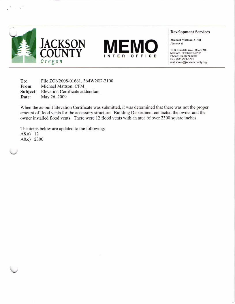
To: From: Subject: Date:
JACKSON COUNTY Oregon
MEMO INTER-OFFICE
File ZON2008-01661, 364W20D-2100 Michael Mattson, CFM Elevation Certificate addendum May 26, 2009
Development Services
Michael Mattson, CFM Planner ff
10 S. Oakdale Ave., Room 100 Medford, OR 97501-2202 Phone: (541)774-6937 Fax: (541 )774-6791 [email protected]
When the as-built Elevation Certificate was submitted, it was determined that there was not the proper amount of flood vents for the accessory structure. Building Department contacted the owner and the owner installed flood vents. There were 12 flood vents with an area of over 2300 square inches.
The items below are updated to the following: A8.a) 12 A8.c) 2300
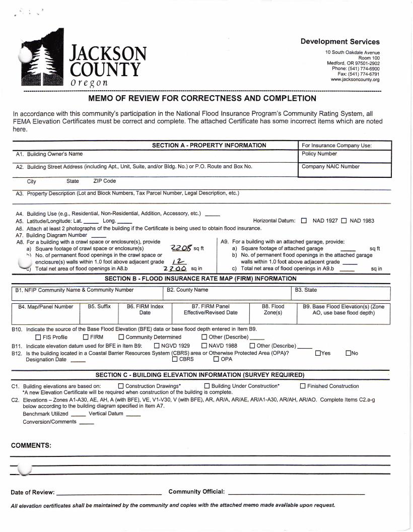
JACKSON COUNTY Oregon
Development Services 10 South Oakdale Avenue
Room 100 Medford , OR 97501-2902
Phone: ( 541 ) 77 4-6900 Fax: (541 ) 774-6791
www.jacksoncounty.org
----------------------------------------------------------------------------------------------------------------------------------------------------------------------------------MEMO OF REVIEW FOR CORRECTNESS AND COMPLETION
In accordance with this community's participation in the National Flood Insurance Program's Community Rating System, all FEMA Elevation Certificates must be correct and complete. The attached Certificate has some incorrect items which are noted here.
SECTION A- PROPERTY INFORMATION For Insurance Company Use:
A1. Building Owner's Name Policy Number
A2. Building Street Address (including Apt., Unit, Suite, and/or Bldg . No.) or P.O. Route and Box No. Company NAIC Number
City State ZIP Code
A3. Property Description (Lot and Block Numbers, Tax Parcel Number, Legal Description, etc.)
A4. Building Use (e.g., Residential, Non-Residential, Addition, Accessory, etc.) __
A5. Latitude/Longitude: Lat.__ Long.__ Horizontal Datum: D NAO 1927 D NAO 1983 A6. Attach at least 2 photographs of the building if the Certificate is being used to obtain flood insurance. A7. Building Diagram Number __ A8. For a building with a crawl space or enclosure(s), provide A9. For a building with an attached garage, provide:
a) Square footage of crawl space or enclosure(s) -~sq ft a) Square footage of attached garage sq ft h ) No. of permanent flood openings in the crawl space or b) No. of permanent flood openings in the attached garage
enclosure(s) walls within 1.0 foot above adjacent grade L.1:::_ walls within 1.0 foot above adjacent grade __ ..,) Total net area of flood openings in A8.b 2..L.0.Q sq in c) Total net area of flood openings in A9.b sq in
SECTION B - FLOOD INSURANCE RATE MAP (FIRM) INFORMATION
B1. NFIP Community Name & Community Number B2. County Name B3. State
B4. Map/Panel Number B5. Suffix B6. FIRM Index B7. FIRM Panel B8. Flood B9. Base Flood Elevation(s) (Zone Date Effective/Revised Date Zone(s) AO, use base flood depth)
B10. Indicate the source of the Base Flood Elevation (BFE) data or base flood depth entered in Item B9.
D FIS Profile D FIRM 0 Community Determined D Other (Describe) __
B11 . Indicate elevation datum used for BFE in Item 89: D NGVD 1929 D NAVO 1988 D Other (Describe) __ B12. Is the building located in a Coastal Barrier Resources System (CBRS) area or Otherwise Protected Area (OPA)? 0Yes 0No
Designation Date __ D CBRS D OPA
SECTION C - BUILDING ELEVATION INFORMATION (SURVEY REQUIRED)
C1. Building elevations are based on: D Construction Drawings* D Building Under Construction* D Finished Construction *A new Elevation Certificate will be required when construction of the building is complete.
C2. Elevations -Zones A1-A30, AE, AH , A (with BFE), VE, V1-V30, V (with BFE), AR, AR/A, AR/AE, AR/A1-A30, AR/AH, AR/AO. Complete Items C2.a-g below according to the building diagram specified in Item A7.
Benchmark Utilized Vertical Datum
Conversion/Comments __
COMMENTS:
Date of Review:--------------- Community Official:
All elevation certificates shall be maintained by the community and copies with the attached memo made available upon request.


![Fundação CERTIFundação CERTI - i3p.it1]. Fundação CERTI - BRAZIL.pdf · Title: Microsoft PowerPoint - CERTI_Presentation_English_2007las turino.ppt Author: Federico Created](https://img.pdfslide.us/doc/110x75/5c4cb1e293f3c304f47a26c1/fundacao-certifundacao-certi-i3pit-1-fundacao-certi-title-microsoft.jpg)