Embed Size (px)
Citation preview
Elephant & Castle Northern Roundabout Consultation Report June 2014 Elephant & Castle Northern Roundabout Consultation Report
Elephant & Castle Northern Roundabout Consultation Report August 2014
Contents 1 Background .................................................................................................................. 1 2 Introduction ................................................................................................................... 3
2.1 Purpose of the Scheme ............................................................................................ 3 2.2 Descriptions of the proposals .................................................................................... 3 2.3 Location maps ........................................................................................................... 4
3 The consultation ........................................................................................................... 5
3.1 Who we consulted ..................................................................................................... 5 3.2 Consultation material, distribution and publicity ........................................................ 5 3.3 Meetings and public exhibitions ................................................................................ 6
4 Overview of consultation responses ............................................................................. 8
4.1 Responses from Members of the Public ................................................................... 8 4.2 Responses from Stakeholders ....................................................................................... 8
5 Responses from members of the public ..................................................................... 10
5.1 Background Questions ............................................................................................ 10 5.2 Identification Questions ........................................................................................... 10 5.3 Key elements of the design ..................................................................................... 11 5.4 Preference for Option A or B for the northbound cycling provision along Elephant and Castle Road ................................................................................................................ 17 5.5 Analysis of the comments provided ........................................................................ 18
5.5.1 General supportive comments ......................................................................... 20 5.5.2 General opposition comments ......................................................................... 20 5.5.3 Cycling Related Issues .......................................................................................... 21 5.5.4 Pedestrian Related Issues ............................................................................... 24 5.5.5 Traffic Related Issues ...................................................................................... 26 5.5.6 Bus Related Issues ......................................................................................... 28 5.5.7 Public Space Related Issues ........................................................................... 28 5.5.8 General Issues ................................................................................................ 29 5.5.9 Alternative Proposal Suggested ...................................................................... 31
6 Responses from statutory bodies and other stakeholders ......................................... 32
6.1 Statutory Stakeholders ............................................................................................ 32 6.2 Political ................................................................................................................... 33 6.3 Campaign Groups ................................................................................................... 35 6.4 Local Community Groups ............................................................................................ 37 6.5 Business/Land Owners ........................................................................................... 40 6.6 Other ............................................................................................................................ 41
7 Conclusion .................................................................................................................. 43

Appendix Appendix A – List of stakeholders consulted Appendix B – Copy of consultation leaflet Appendix C – Map of leaflet distribution area Appendix D – Notes from Public Exhibition Appendix E – Response to issues raised Appendix F – Proposal from ‘Maidstoneonbike’ Appendix G – Proposal from Southwark Cyclists Appendix H – Submission from Elephantandcastelroundabout.org Appendix I – Updated design drawing Appendix J – Local cycle route map
1
1 Background Transport for London (TfL) believes there is a clear case for radical changes at the northern roundabout at Elephant & Castle. We want to reduce the impact traffic has on the area and make it more attractive in order to support the wider regeneration plans for the area. As well as improving facilities for all roads users and the need to improve safety at the junction we also want to find a better balance between the needs of drivers and those of pedestrians and cyclists. Road safety has long been a cause for concern at the northern roundabout and the collision statistics show it is consistently the worst performing junction of its kind in London; as a result it is on the Better Junctions programme for remedial work by 2016. The junction also forms part of the wider Elephant & Castle Opportunity Area (which aims to deliver 5,000 new jobs and 4,000 new homes by 2026) and as such the local transport network needs to contribute to the growth and economic vitality of the area. The funding is available to the scheme from third-party Community Infrastructure Levy (CIL) contributions. The project is focused on highway improvements at the Elephant & Castle northern roundabout to address areas of poor performance, whilst also seeking to contribute to enhancing the vitality of the local area. The key issues at the junction are summarised below: Pedestrians Large numbers of pedestrians use the area, either as they interchange between public transport modes, or use the facilities in the area (including the shopping centre and South Bank University). Surveys undertaken in 2010 suggest that there are around 15,000 pedestrian movements through the vicinity in peak periods. The current layout of the northern roundabout requires pedestrians to use at least one of the seven subways for many of the linkages. These are relatively narrow and indirect, and also raise concerns around personal security. Cyclists On the roundabout itself there are currently no cycle facilities provided. Cycle Superhighway 7 (CS7) provides a cycle bypass using Elliott’s Row and Princess Street to the west of the roundabout. Despite this, counts show cycle flows in excess of 1,300 cyclists per hour using the roundabout at peak times. It is also proposed that the North-South Cycle Super Highway will terminate at the northern roundabout. Road Safety In the 36 month period up to 30 August 2012, there were a total of 97 injury collisions around the roundabout, giving an average of 32.3 collisions per year. The roundabout is consistently the worst performing junction of its kind in London in terms of road safety. 49% of all collisions involved cyclists compared to an average of 21% on the Transport for London Road Network (TLRN). The proportion of collisions involving pedestrians is in line with the TLRN average at around 5.5%. Buses Elephant & Castle is one of the key bus hubs in London, served by 28 bus routes during the day (seven at night), with 280 buses per hour in each direction through the northern roundabout at peak times making it a key bus interchange. Urban design/Streetscape The quality of the urban realm is poor with the area dominated by road traffic and the subway ramp structures on all sides of the roundabout. There is very little crossing provision for pedestrians at surface level and most movements require the use of the extensive subway network.
2
General traffic flow The Inner Ring Road and Congestion Charge Zone boundary runs along the Elephant & Castle link road and A201 New Kent Road meaning this part of the TLRN is a strategically important orbital route. As a result, the area experiences high traffic flows. The complexity of the junction has necessitated a considerable development period with initial feasibility work commencing in 2007. After reviewing the initial options with key stakeholders we believed we could go further and be more innovative and in late 2012 TfL redesigned the northern roundabout with a view to a truly transformational scheme. Different combinations of flyovers and underpasses were considered, both for motorised traffic and/or pedestrians and cyclists. We also considered the potential re-routing of the Inner Ring Road in this area. Several viable concepts were subject to key stakeholder workshops in early 2013 and the southern peninsula concept was the preferred option. The decision to continue work on the southern peninsula was made by the E&C Strategic Forum (which includes senior political representation from Southwark Council and key figures from Greater London Authority and TfL) in June 2013.
3
2 Introduction
We recently invited the public and key stakeholders to comment on our proposals to remove the northern roundabout at Elephant and Castle. 2.1 Purpose of the Scheme The northern roundabout is dominated by motor vehicles and the urban realm is poor. The junction has one of the highest number of road collisions of any junction in the capital. It is also a busy cycle route yet there are currently limited cycling facilities. Large numbers of pedestrians use the area but the current layout requires them to use at least one of the seven subways to move around. The subway system is a source of anti-social behaviour and presents personal safety concerns for some users.
Our proposals would remove the roundabout system and create two way working. This would allow for the creation of a major new public space transforming the area for those who live, work and travel in Elephant & Castle. Transforming the road layout would allow for dedicated cycle routes through the junction, a better road layout to reduce collisions and smoother journeys. The replacement of the subways with pedestrian crossings would allow people to cross directly, easily and safely through the area.
2.2 Descriptions of the proposals
The proposals include the following changes for each type of road user: Pedestrians Subways are in-filled and replaced by wide, signalised crossings which better provide for pedestrian desire lines. There will be a significantly enhanced public space facilitating improved interchange between different transport modes. Cycling Dedicated and direct cycle routes through the junction will be provided with areas of conflict reduced and road safety improved.
Road Safety Many of the vehicle manoeuvres undertaken at the roundabout which have historically resulted in collisions are no longer required under the peninsula configuration. Detailed collision analysis has been undertaken together with a stage 1 Road Safety Audit. It is now anticipated the scheme will result in a 33% collision saving. Buses Bus shelters will be upgraded and remaining bus stops would be made DDA compliant where possible. The bus stop serving buses towards Camberwell would be re-located from outside the shopping centre to Walworth Road. This would help improve congestion at the bus stops and also improve conditions for cyclists as they would have one less stop to travel past on this busy stretch of road. Urban Realm An engaging and usable space will be developed which will facilitate local vitality, enhancing the area as a destination in conjunction with planned growth in the area. The peninsula can become a focal point of the community, developing as a place in its own right whilst also enhancing the existing interchange function.
4
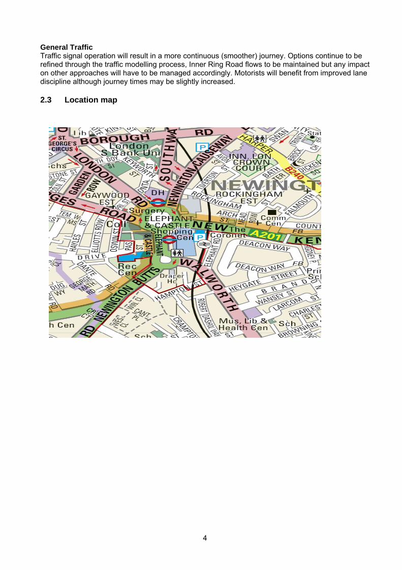
General Traffic Traffic signal operation will result in a more continuous (smoother) journey. Options continue to be refined through the traffic modelling process, Inner Ring Road flows to be maintained but any impact on other approaches will have to be managed accordingly. Motorists will benefit from improved lane discipline although journey times may be slightly increased. 2.3 Location map
5
3 The consultation The consultation, which ran from 12 March to 30 April 2014, was designed to enable TfL to understand local opinion about our proposals to change the road layout at the northern roundabout at Elephant & Castle. We are committed to implementing change at the roundabout therefore the consultation was not about whether we do or do not make changes, rather the potential outcomes of the consultation were that:
We decide the consultation raises no issues that should prevent us from proceeding with the scheme as originally planned.
We modify the scheme in response to issues raised in consultation. The objectives of the consultation were:
To give stakeholders and the public easily-understandable information about the proposals and allow them to respond.
To understand the level of support or opposition for our plans. To understand any issues that might affect the proposal of which we were not previously
aware. To understand concerns and objections. To allow respondents to make suggestions.
3.1 Who we consulted
The public consultation intended to seek the views of people living close to the junction and within the wider Elephant Opportunity Area. We were also keen to seek the views of local businesses and commuters who regularly use the transport interchange. We also consulted stakeholders including Southwark Council, local land owners, traffic police, London TravelWatch, Members of Parliament, Assembly Members and local interest, transport and business groups. A list of the stakeholders we consulted is shown in appendix A and a summary of their responses given is in Section 6. 3.2 Consultation material, distribution and publicity
We produced a leaflet explaining our proposals which was distributed to approximately 11,000 local households and businesses within the Elephant Opportunity Area. A copy of this leaflet is shown in appendix B and a map of the distribution area can be found in appendix C. The leaflet was also sent by email to stakeholders. We also notified approximately 100,000 registered Oyster Card users who used the interchange (both Tube and Bus), or were registered for cycle hire or congestion charge in the area. In addition, we carried out face to face activity on 25 and 29 March, handing out leaflets to users of the bus stop and subways, and approximately 1,500 leaflets were distributed during this activity. We held a public exhibition over two days and following this the plans were available at the John Harvard Library, 211 Borough High Street, London SE1 1JA. The consultation asked five specific questions and gave a free text response area for people to provide detailed comments. The specific questions asked were:
1. We asked people to identify themselves as local resident/employed locally/business
owner/commuter/visitor/other 2. We asked people what types of transport they use locally 3. We asked people if they represented a group 4. We asked them if they agreed with the key elements of the design
6
5. We asked them if they preferred Option A or B for the northbound cycling provision along Elephant & Castle Road
We invited people to respond by completing an online questionnaire on our consultation tool (tfl.gov.uk/elephantandcastle) or by using a pre-paid reply slip. People could also respond by emailing [email protected], by post or by calling Customer Services on 0343 222 1234. The consultation was advertised over 5 weeks in the London Evening Standard and Southwark News. We also promoted the consultation through the TfL’s Taxi and Freight Trade Bulletins. Southwark Council promoted the consultation through their Elephant Magazine and Resident’s E-bulletin. The scheme and consultation also received editorial coverage within the Evening Standard on 4 March and the South London Press on 14 March. A representative of the Consultation Team also attended the local Community Council on 2 February to promote the forthcoming consultation.
3.3 Meetings and public exhibitions On 17 March we had an information stand within the cafeteria at the London College of Communications. This was an opportunity for students and staff to find out about our proposals and to encourage them to take part in the consultation. Following this we held a public exhibition on our proposals at the Typo Cafe in the London College of Communications on the following dates:
Tuesday 25 March 16:00 – 20:00 Saturday 29 March 11:30 – 15:30
We invited all those we distributed consultation materials to attend. It was an opportunity for attendees to view detailed maps of the scheme, speak to the scheme designers and have any detailed queries answered. Animations of the traffic modelling along with environmental information were also available. The sessions were manned by the project team and a representative from Southwark Council and Delancey (the new owners of the shopping centre site) were present. At both sessions a stand was also manned by the Elephantandcastleroundabout.org, a campaign group who are against our proposals. Approximately 127 people attended over the two sessions. Notes of the key issues raised during each session can be found in appendix D. Attendees were requested to ensure they responded to the questionnaire and as such these issues are reflected within the consultation responses. Our response to these issues is detailed in ‘Reponses to Issues Raised’ document which can be found in appendix E. Key issues common across both sessions are noted below:
Traffic
Objections to banned turns into and out of Newington Causeway because of impact on rat running on local roads and increase on journey times
Concerns about overall journey time impact for traffic from the scheme Request for scheme to include 20mph zone Concern about environmental impact from traffic
Pedestrians
Both support and opposition for removal of subways Concern about pedestrian wait time at crossings and impact on journey times
Cyclists
7
Concern that both options will create a left hook hazard for northbound cyclists at St George’s Road junction
Concern about capacity of Option B’s cycle path given likely cycle flows and risk of pedestrian/cycle conflict
Buses
Concern about impact on bus journey times Concern about re-locating bus stop to Walworth Road due to safety at night and distance
from Northern Line station All Modes
Concern layout would be confusing for all road users Public Space
Questions over the location of the space given proximity to large busy roads Concerns about space being used for anti-social behaviour Concerns about pedestrian/cycle conflict from the cycle link
Other
Requests for more radical solutions to be put forward such as elevated cycle paths of pedestrian footways
8
4 Overview of consultation responses
We received a total of 2032 consultation responses within consultation timeline. Of those 1987 were from members of the public and 45 were from stakeholders/stakeholder groups. However there were duplicate submissions from two stakeholder groups, so for reporting purposes these have been consolidated into one submission for each organisation, leaving a total of 42 stakeholder responses.
Below is a summary of the key findings for both respondent groups. The following sections of this report analyse the responses and emerging themes in more detail for each respondent group. 4.1 Responses from Members of the Public
The respondents were asked if they agreed with the five key elements of the design and over 80% of respondents indicated they agreed with each of the five design elements. We asked if people would prefer option A or B for the northbound cycle provision along Elephant & Castle Link Road, just over half of the respondents, 1056 (53%) indicated they preferred option B; 678 (34%) preferred Option A and there were 253 (13%) of respondents who did not indicate a preference. However, it is important to note that of the 1,987 responses from members of the public, 1,110 (56%) also took the opportunity to make comments about the proposals. Some felt that, although they agreed with the key elements of the design, our design did not deliver on these design principles. The comments have been grouped into themes and the top 10 (in terms of number of people making comments) are listed below:
Requests for further cycle lane improvements General comments in support of the proposals Opposition to removing the subways Concerns about impact on traffic Concerns about cycling and pedestrian conflict Objections to banned turns into and out of Newington Causeway/New Kent Road Comments in support of Option B Concerns about the consultation process Suggested alternative proposals Support for the concerns raised by London Cycle Campaign/Southwark Cyclists that design
does not adequately address cycle safety issues A full list of the issues raised by theme can be found in Section 5.5 along with a detailed analysis of the issues raised. 4.2 Responses from Stakeholders Of the 42 responses received, 8 broadly supported the proposals, 23 supported but with some concerns and caveats and 11 opposed the proposals. Two groups also offered counter proposals. Nine groups showed a preference for Option A and 12 for Option B, 13 of the groups did not state a preference for either option. One of the stakeholder groups, Elephantandcastleroundabout.org , who are a local campaign group opposed to our plans, submitted a detailed report critiquing our proposals and were also one of the groups offering a counter proposal. They claim their report and proposal has the support of over 300 signatories who had signed up to support the campaign.
Common key issues raised by stakeholder groups included:
Plans do not adequately address cycling safety issues
9
Some support for retaining some/all of subways and concerns about impact on overall pedestrian journey times and time allocated to pedestrian crossings
Objection to the relocation of the bus stop to Walworth Road due to inconvenience to bus passengers
Objections to banned turns into and out of Newington Causeway/New Kent Road due to concerns about local rat running and impact on overall journey times
Requests for 20 mph zone That plans need to be worked up alongside the plans for the re-developed shopping centre
and that consultation process has been flawed as did not engage early enough when designs were being formulated
Impact on car journey times and the effect of this on air pollution
10
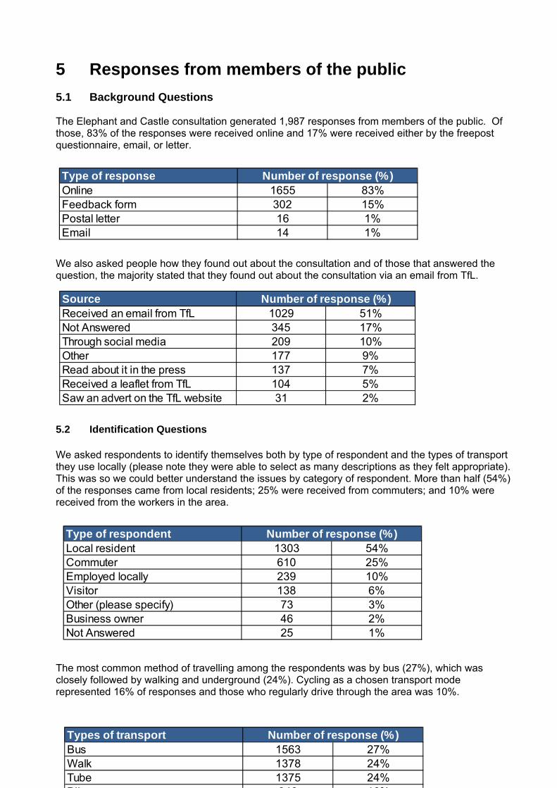
SourceReceived an email from TfL 1029 51%Not Answered 345 17%Through social media 209 10%Other 177 9%Read about it in the press 137 7%Received a leaflet from TfL 104 5%Saw an advert on the TfL website 31 2%
Number of response (%)
5 Responses from members of the public 5.1 Background Questions
The Elephant and Castle consultation generated 1,987 responses from members of the public. Of those, 83% of the responses were received online and 17% were received either by the freepost questionnaire, email, or letter.
We also asked people how they found out about the consultation and of those that answered the question, the majority stated that they found out about the consultation via an email from TfL.
5.2 Identification Questions We asked respondents to identify themselves both by type of respondent and the types of transport they use locally (please note they were able to select as many descriptions as they felt appropriate). This was so we could better understand the issues by category of respondent. More than half (54%) of the responses came from local residents; 25% were received from commuters; and 10% were received from the workers in the area.
The most common method of travelling among the respondents was by bus (27%), which was closely followed by walking and underground (24%). Cycling as a chosen transport mode represented 16% of responses and those who regularly drive through the area was 10%.
Type of responseOnline 1655 83%Feedback form 302 15%Postal letter 16 1%Email 14 1%
Number of response (%)
Type of respondentLocal resident 1303 54%Commuter 610 25%Employed locally 239 10%Visitor 138 6%Other (please specify) 73 3%Business owner 46 2%Not Answered 25 1%
Number of response (%)
Types of transportBus 1563 27%Walk 1378 24%Tube 1375 24%Bik 946 16%
Number of response (%)
11
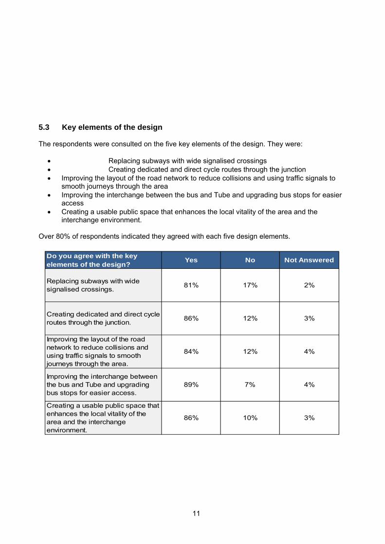
5.3 Key elements of the design
The respondents were consulted on the five key elements of the design. They were:
Replacing subways with wide signalised crossings Creating dedicated and direct cycle routes through the junction Improving the layout of the road network to reduce collisions and using traffic signals to
smooth journeys through the area Improving the interchange between the bus and Tube and upgrading bus stops for easier
access Creating a usable public space that enhances the local vitality of the area and the
interchange environment.
Over 80% of respondents indicated they agreed with each five design elements.
Do you agree with the key elements of the design?
Yes No Not Answered
Replacing subways with wide signalised crossings.
81% 17% 2%
Creating dedicated and direct cycle routes through the junction.
86% 12% 3%
Improving the layout of the road network to reduce collisions and using traffic signals to smooth journeys through the area.
84% 12% 4%
Improving the interchange between the bus and Tube and upgrading bus stops for easier access.
89% 7% 4%
Creating a usable public space that enhances the local vitality of the area and the interchange environment.
86% 10% 3%
12
However, it is important to note that approximately 56% of respondents provided comments in the free text section of the questionnaire. These comments are explored in detail in Section 5.5 of the report. What follows is an indication of the top 10 issues by those that said they supported all the five elements, those that did not support all of the five elements, and then those that did not state an answer.
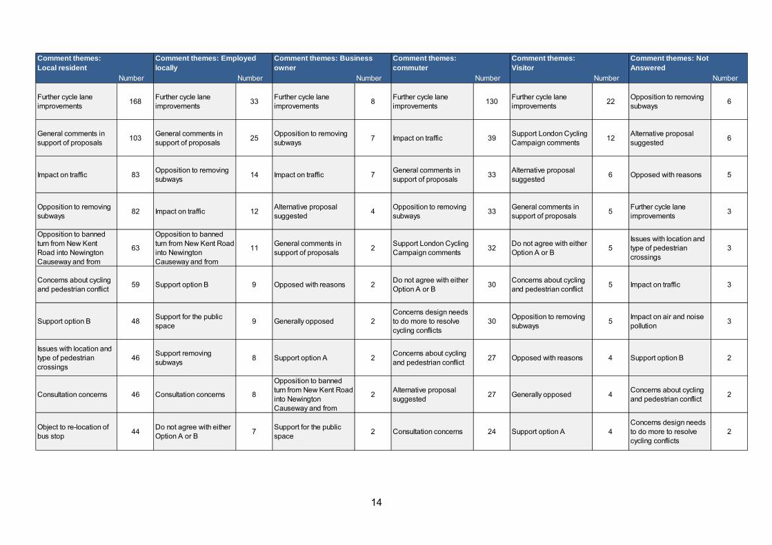
We have also analysed the responses by respondent type and transport type.
Respondent type The majority of responses did not vary greatly when analysed by respondent type versus the overall responses, with most responses being within 5% of the general responses. However the biggest difference was business owners with over 18% less of them supporting the removal of the subways, 10% less the changes to the road layout and 6% less the principle of creating a public space. Those
Number Number Number
Further cycle lane improvements
77Opposition to removing subways
14Further cycle lane improvements
7
General comments in support of proposals
72Do not agree with either Option A or B
12Alternative proposal suggested
7
Support option B 33 Generally opposed 8Support London Cycling Campaign comments
6
Support removing subways
25 Impact on traffic 8 Opposed with reasons 5
Support for the public space
25 Consultation concerns 8 Impact on traffic 4
Concerns about cycling and pedestrian conflict
23Further cycle lane improvements
7Impact on air and noise pollution
4
Impact on traffic 17Concerns about cycling and pedestrian conflict
6Concerns design needs to do more to resolve cycling conflicts
3
Issues with location and type of pedestrian crossings
16Impact on air and noise pollution
6Opposition to removing subways
3
Alternative proposal suggested
15 Opposed with reasons 5Issues with location and type of pedestrian crossings
3
Support option A 14Support London Cycling Campaign comments
4Do not agree with either Option A or B
2
Comment themes from those who supported all 5 design elements
Comment themes from those who did not support all 5 design elements
Comment themes from those who did not answer to the question

13
who declared themselves as visitors were also 9% less likely to support removing subways than the general response figure and 12% less supportive of changes to the road layout. We have also pulled out the top 10 comment themes by respondent type (this is denoted by the number of comments made). It is important to note that the comment themes listed are only those that appear in the top 10 themes for either of the transport types.
14
Comment themes: Local resident
Comment themes: commuter
Comment themes: Visitor
Comment themes: Not Answered
Number Number Number Number Number Number
Further cycle lane improvements
168Further cycle lane improvements
33Further cycle lane improvements
8Further cycle lane improvements
130Further cycle lane improvements
22Opposition to removing subways
6
General comments in support of proposals
103General comments in support of proposals
25Opposition to removing subways
7 Impact on traffic 39Support London Cycling Campaign comments
12Alternative proposal suggested
6
Impact on traffic 83Opposition to removing subways
14 Impact on traffic 7General comments in support of proposals
33Alternative proposal suggested
6 Opposed with reasons 5
Opposition to removing subways
82 Impact on traffic 12Alternative proposal suggested
4Opposition to removing subways
33General comments in support of proposals
5Further cycle lane improvements
3
Opposition to banned turn from New Kent Road into Newington Causeway and from
63
Opposition to banned turn from New Kent Road into Newington Causeway and from
11General comments in support of proposals
2Support London Cycling Campaign comments
32Do not agree with either Option A or B
5Issues with location and type of pedestrian crossings
3
Concerns about cycling and pedestrian conflict
59 Support option B 9 Opposed with reasons 2Do not agree with either Option A or B
30Concerns about cycling and pedestrian conflict
5 Impact on traffic 3
Support option B 48Support for the public space
9 Generally opposed 2Concerns design needs to do more to resolve cycling conflicts
30Opposition to removing subways
5Impact on air and noise pollution
3
Issues with location and type of pedestrian crossings
46Support removing subways
8 Support option A 2Concerns about cycling and pedestrian conflict
27 Opposed with reasons 4 Support option B 2
Consultation concerns 46 Consultation concerns 8
Opposition to banned turn from New Kent Road into Newington Causeway and from
2Alternative proposal suggested
27 Generally opposed 4Concerns about cycling and pedestrian conflict
2
Object to re-location of bus stop
44Do not agree with either Option A or B
7Support for the public space
2 Consultation concerns 24 Support option A 4Concerns design needs to do more to resolve cycling conflicts
2
Comment themes: Employed locally
Comment themes: Business owner
15
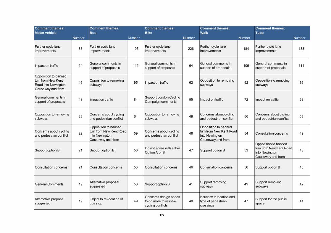
Transport type The responses did not vary greatly when analysed by transport type versus the overall responses, with all responses being within 5% of the general responses. The biggest change was drivers who were more likely by 4-5% to object to cycling provision and the change in the road layout. Similarly cyclists were less supportive (by 4%) to removing the subways and changing the road layout. We have also pulled out the top 10 comment themes by respondent type (this is denoted by the number of comments made). It is important to note that the comments theme listed are only those that appear in the top 10 themes for either of the transport types.
16
Comment themes: Motor vehicle
Comment themes: Bus
Comment themes: Bike
Comment themes: Walk
Comment themes: Tube
Number Number Number Number Number
Further cycle lane improvements
83Further cycle lane improvements
195Further cycle lane improvements
226Further cycle lane improvements
184Further cycle lane improvements
183
Impact on traffic 54General comments in support of proposals
115General comments in support of proposals
64General comments in support of proposals
105General comments in support of proposals
111
Opposition to banned turn from New Kent Road into Newington Causeway and from
46Opposition to removing subways
95 Impact on traffic 62Opposition to removing subways
92Opposition to removing subways
86
General comments in support of proposals
43 Impact on traffic 84Support London Cycling Campaign comments
55 Impact on traffic 72 Impact on traffic 68
Opposition to removing subways
28Concerns about cycling and pedestrian conflict
64Opposition to removing subways
49Concerns about cycling and pedestrian conflict
56Concerns about cycling and pedestrian conflict
58
Concerns about cycling and pedestrian conflict
22
Opposition to banned turn from New Kent Road into Newington Causeway and from
59Concerns about cycling and pedestrian conflict
48
Opposition to banned turn from New Kent Road into Newington Causeway and from
54 Consultation concerns 49
Support option B 21 Support option B 56Do not agree with either Option A or B
47 Support option B 53
Opposition to banned turn from New Kent Road into Newington Causeway and from
48
Consultation concerns 21 Consultation concerns 53 Consultation concerns 46 Consultation concerns 50 Support option B 45
General Comments 19Alternative proposal suggested
50 Support option B 41Support removing subways
49Support removing subways
42
Alternative proposal suggested
19Object to re-location of bus stop
49Concerns design needs to do more to resolve cycling conflicts
40Issues with location and type of pedestrian crossings
47Support for the public space
41
17
5.4 Preference for Option A or B for the northbound cycling provision along Elephant and
Castle Road
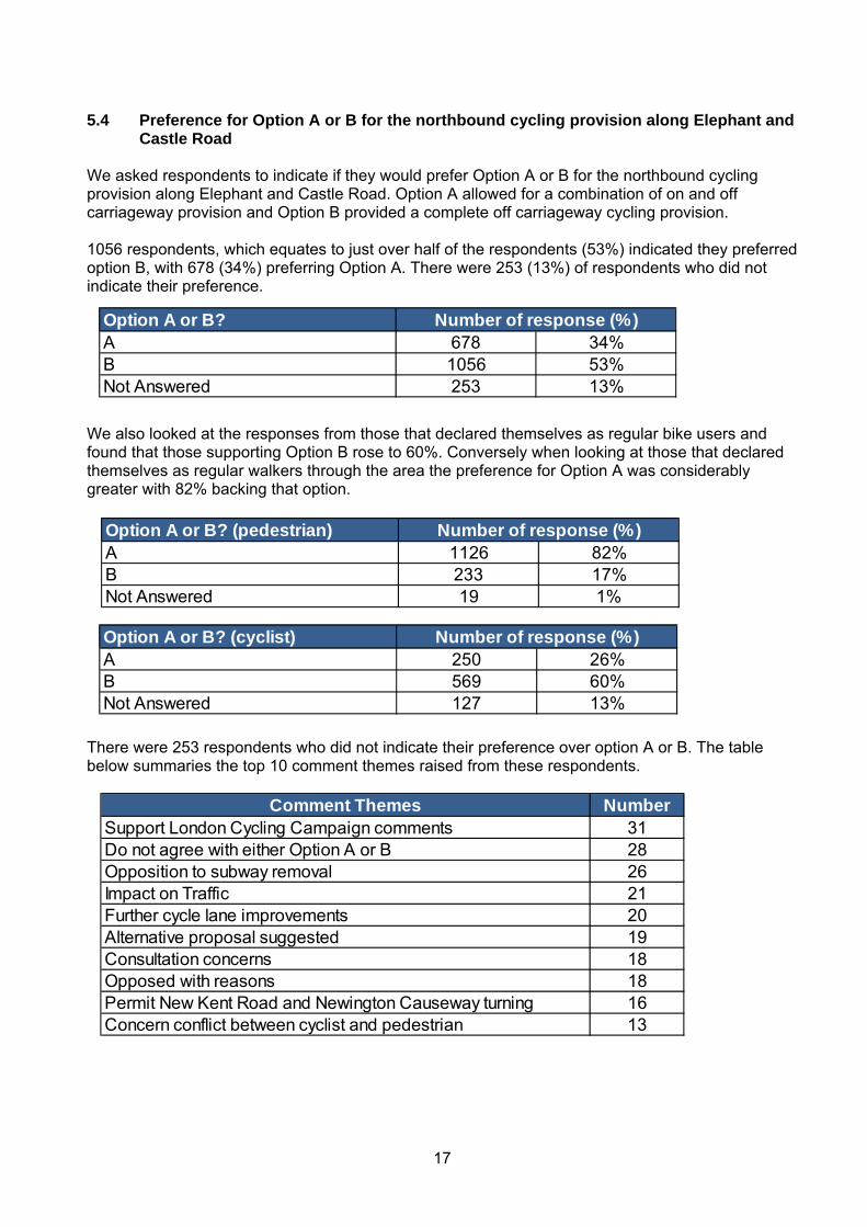
We asked respondents to indicate if they would prefer Option A or B for the northbound cycling provision along Elephant and Castle Road. Option A allowed for a combination of on and off carriageway provision and Option B provided a complete off carriageway cycling provision. 1056 respondents, which equates to just over half of the respondents (53%) indicated they preferred option B, with 678 (34%) preferring Option A. There were 253 (13%) of respondents who did not indicate their preference.
We also looked at the responses from those that declared themselves as regular bike users and found that those supporting Option B rose to 60%. Conversely when looking at those that declared themselves as regular walkers through the area the preference for Option A was considerably greater with 82% backing that option.
There were 253 respondents who did not indicate their preference over option A or B. The table below summaries the top 10 comment themes raised from these respondents.
Option A or B? (pedestrian)A 1126 82%B 233 17%Not Answered 19 1%
Number of response (%)
Option A or B? (cyclist)A 250 26%B 569 60%Not Answered 127 13%
Number of response (%)
Option A or B?A 678 34%B 1056 53%Not Answered 253 13%
Number of response (%)
Comment Themes NumberSupport London Cycling Campaign comments 31Do not agree with either Option A or B 28Opposition to subway removal 26Impact on Traffic 21Further cycle lane improvements 20Alternative proposal suggested 19Consultation concerns 18Opposed with reasons 18Permit New Kent Road and Newington Causeway turning 16Concern conflict between cyclist and pedestrian 13
18
5.5 Analysis of the comments provided In question six of the questionnaire we provided a free text box for respondents to provide any comments they may have on the scheme. 1,110 respondents took the opportunity to make comments about the proposals representing 56% of all respondents. The issues they raised have been grouped into themes, with a section on each theme summarising the issues raised. It is important to note that many respondents raised more than one issue; hence the total number of comments will exceed the number of respondents who made comments. The issues raised have been considered by the project team and our detailed response to them can be found in appendix E of this report.
19
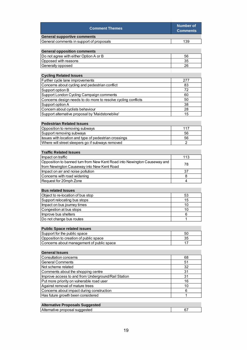
Comment ThemesNumber of Comments
General supportive commentsGeneral comments in support of proposals 139
General opposition commentsDo not agree with either Option A or B 56Opposed with reasons 35Generally opposed 26
Cycling Related IssuesFurther cycle lane improvements 277Concerns about cycling and pedestrian conflict 83Support option B 72Support London Cycling Campaign comments 60Concerns design needs to do more to resolve cycling conflicts 50Support option A 38Concern about cyclists behaviour 28Support alternative proposal by 'Maidstonebike' 15
Pedestrian Related IssuesOpposition to removing subways 117Support removing subways 56Issues with location and type of pedestrian crossings 56Where will street sleepers go if subways removed 2
Traffic Related IssuesImpact on traffic 113Opposition to banned turn from New Kent Road into Newington Causeway and from Newington Causeway into New Kent Road
78
Impact on air and noise pollution 37Concerns with road widening 8Request for 20mph Zone 4
Bus related IssuesObject to re-location of bus stop 53Support relocating bus stops 15Impact on bus journey times 10Congestion at bus stops 10Improve bus shelters 6Do not change bus routes 1
Public Space related issues Support for the public space 50Opposition to creation of public space 35Concerns about management of public space 17
General IssuesConsultation concerns 68General Comments 51Not scheme related 32Comments about the shopping centre 31Improve access to and from Underground/Rail Station 31Put more priority on vulnerable road user 16Against removal of mature trees 10Concerns about impact during construction 6Has future growth been considered 1
Alternative Proposals SuggestedAlternative proposal suggested 67
20
5.5.1 General supportive comments There were 139 comments noting general support for the plans. The nature of the comments in support of the plans indicate that improvements are welcome, much needed and long overdue. Respondents were also keen for works to start as soon as possible. People also noted support for improving cycling facilities and making it safer for pedestrians at night by removing subways. A sample of comments is below: “This is a fantastic change for the area. It is welcomed with open arms!” “Looks great and about time.” “Great project, many thanks for implementing it as quickly as possible.” “Please can you get on with it! We have been waiting for regeneration for decades!!”
5.5.2 General opposition comments
There were approximately 177 comments that noted opposition to the scheme. Of this number 60 were opposed on the grounds put forward by the London Cycling Campaign in conjunction with Southwark Cyclists (explored in detail under cycling issues); a further 56 stated they could agree with neither Option A or B as currently proposed; 35 stated general opposition to the proposals and provided reasons; and a further 26 made non-specific comments in opposition to the plans. Agree with neither Option A or B The majority of reasons given why respondents felt they could not support either option were based on cycling related issues with a general feeling that nether options presented a satisfactory or safe solution for cyclists. Many of the reasons noted were similar to those identified by the London Cycling Campaign in conjunction with Southwark Cyclists, but other issues included concerns about the capacity for the likely volume of cyclists and that neither option solves the conflict between buses and cyclists at bus stops. Reasons other than cycling concerns were also noted and included:
Plans do not encourage a reduction in traffic and would worsen traffic flows and impact on
noise and air pollution Plans will result in longer journey times for everyone Opposition to removal of subways Doesn’t address bus congestion or location of bus stops Doesn’t improve interchange between bus and tube
Opposed with reasons provided A total of 35 respondents stated that they were generally opposed to the proposed scheme and provided an accompanying justification. The most common reason is because the proposed scheme is likely to impact on traffic. Table below summarises the reasons provided (some respondents provided more than one reason) and the issues raised have been explored under each of the issues headings in the relevant sections:
Reasons Number of comments
Impact on traffic 14 Alternative proposal suggested 12 Further Cycle Lane Improvements 10 Consultation concerns 7
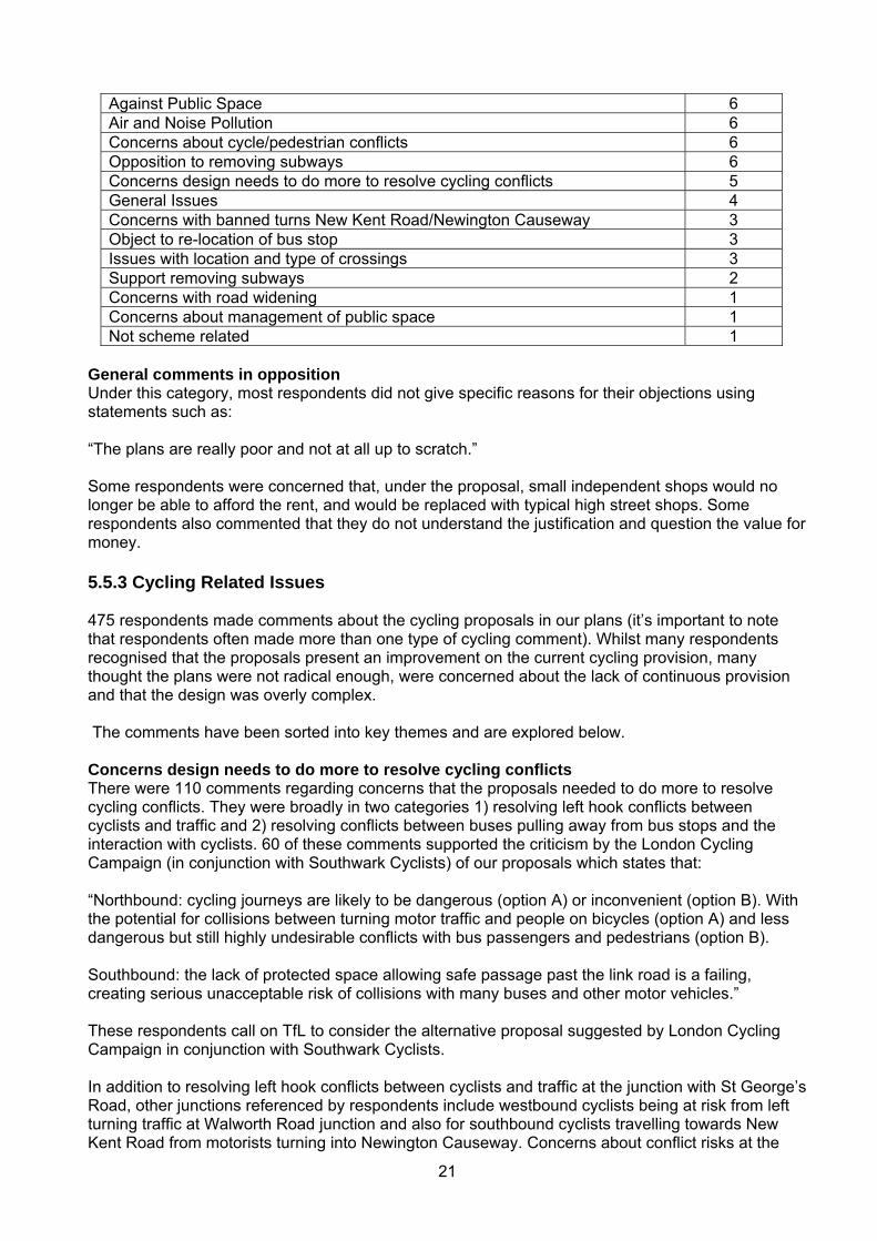
21
Against Public Space 6 Air and Noise Pollution 6 Concerns about cycle/pedestrian conflicts 6 Opposition to removing subways 6 Concerns design needs to do more to resolve cycling conflicts 5 General Issues 4 Concerns with banned turns New Kent Road/Newington Causeway 3 Object to re-location of bus stop 3 Issues with location and type of crossings 3 Support removing subways 2 Concerns with road widening 1 Concerns about management of public space 1 Not scheme related 1
General comments in opposition Under this category, most respondents did not give specific reasons for their objections using statements such as: “The plans are really poor and not at all up to scratch.” Some respondents were concerned that, under the proposal, small independent shops would no longer be able to afford the rent, and would be replaced with typical high street shops. Some respondents also commented that they do not understand the justification and question the value for money. 5.5.3 Cycling Related Issues 475 respondents made comments about the cycling proposals in our plans (it’s important to note that respondents often made more than one type of cycling comment). Whilst many respondents recognised that the proposals present an improvement on the current cycling provision, many thought the plans were not radical enough, were concerned about the lack of continuous provision and that the design was overly complex. The comments have been sorted into key themes and are explored below. Concerns design needs to do more to resolve cycling conflicts There were 110 comments regarding concerns that the proposals needed to do more to resolve cycling conflicts. They were broadly in two categories 1) resolving left hook conflicts between cyclists and traffic and 2) resolving conflicts between buses pulling away from bus stops and the interaction with cyclists. 60 of these comments supported the criticism by the London Cycling Campaign (in conjunction with Southwark Cyclists) of our proposals which states that: “Northbound: cycling journeys are likely to be dangerous (option A) or inconvenient (option B). With the potential for collisions between turning motor traffic and people on bicycles (option A) and less dangerous but still highly undesirable conflicts with bus passengers and pedestrians (option B). Southbound: the lack of protected space allowing safe passage past the link road is a failing, creating serious unacceptable risk of collisions with many buses and other motor vehicles.” These respondents call on TfL to consider the alternative proposal suggested by London Cycling Campaign in conjunction with Southwark Cyclists. In addition to resolving left hook conflicts between cyclists and traffic at the junction with St George’s Road, other junctions referenced by respondents include westbound cyclists being at risk from left turning traffic at Walworth Road junction and also for southbound cyclists travelling towards New Kent Road from motorists turning into Newington Causeway. Concerns about conflict risks at the
22
London Road junction were also raised with worries that it would be hard to negotiate two lanes of traffic to access cycle lane and Advanced Stop Line (ASL). Some were also concerned that cyclists wishing to turn right or access the public space from London Road would need to merge across two lanes of traffic. The area most noted for bus/cycle conflict concerns was the plans for the Elephant Link Road heading southbound past the stops at the shopping centre. Whilst it was recognised that moving one of the stops will help, the current plans still mean cyclists have to pass busy bus stops with a high risk of bus/cycle conflict remaining. A similar situation at London Road was also frequently noted as a concern as was the cycle lane alongside the bus stops northbound at Elephant Link Road in Option A.
Other conflict issues referenced included:
Cyclists travelling from New Kent Road or Newington Causeway to London Road who have to move across two lanes of traffic from the segregated lane in a short period of time
Cyclists using the cycle link to use the segregated lane on St George’s Road will need to make a sharp left to join it and may cause conflict with cyclists coming in the other direction. Similarly they will have to negotiate traffic turning right into St George’s Road across their path
The provision of a bus-stop bypass southbound on Newington Causeway was praised but there were concerns this was also needed northbound, and also in other locations such as Old Kent Road and Walworth Road
No ASL for cyclists from the south at northern pedestrian crossing at E&C, or coming in from New Kent Road or Newington Causeway
Further Cycle Lane Improvements There were 277 comments regarding the cycle lanes with many making requests for further segregated and direct cycle lanes or suggesting improvements to the current proposals (expressing concern over breaks/gaps in cycle routes). Some respondents felt that while they agreed with our design principle of creating dedicated and direct cycle lanes through the junction, our actual proposal did not offer this. They felt that the balance was still in favour of traffic and the design would not encourage the uptake of cycling desired by the Mayor nor be able to cope with an increase in cycling demand. The majority called for direct and segregated routes through the entire junction that follow the flow of traffic and on each arm of the junction. Principal issues were the lack of continuity of cycle lane provision with cyclists having to re-join carriageway on too many occasions. Opinion was divided as to whether cycle lanes should be on road or footway but the general consensus was that they need to be fully segregated. Another frequent suggestion was the use of bus stop bypasses to facilitate segregated routes. Respondents also made requests for a number of additional cycle lane locations including:
Better provision of segregated lanes in the clockwise direction between St George’s Road
and Newington Causeway. Dedicated two-way cycle lanes on London Road and New Kent Road. Provision of a cycle lane southbound on Elephant Link Road was also raised, with
suggestions of using the central reservation to run a two way cycle lane or widening the footway to allow for an off-road cycle lane.
Requests for a cycle lane that allows cyclists to turn left from Newington Causeway into New Kent Road.
Of the current cycle lanes the following concerns were raised:
safety of shared bus and cycle lanes
23
safety of cycle lanes positioned between bus and traffic lanes the width of the cycle lanes and whether they are wide enough to offer adequate protection
and to meet likely cycle demand flows. With suggestions of a minimum 2.5m width the angle at the start of the off road provision at the junction with St George’s Road side roads on St George’s Road appear to have priority over the cycle lane stretch of cycle lane southbound on Elephant Link Road as the island segregation will
prevent cyclists merging into straight ahead lane before left turning vehicles begin to pull across
Request that the cycle lane is continuous from New Kent Road to London Road to stop cycles having to cross two lanes of traffic and fit into a small refuge space
There were several suggestions that if improvements were made to the current by-pass it would encourage better usage and keep more cyclists away from the junction. These included:
Re-instate Toucan crossing linking Elephant Road and Meadow Row Build an extension to the eastern bypass using Elephant Road Improve signage, lighting and maintenance Ensure better green phases for cycles when crossing major roads to allow quicker and more
seamless journeys
There were also several suggestions to use the subways for cyclists and reduce pavements and/or number of traffic lanes and remove traffic islands to create the space to enable better cycling provision. There were also a number of requests for cyclists to have their own signal phase.
Justification for supporting Option A There were 38 comments detailing why respondents had chosen Option A. These included views that Option A presents a more practical solution to cope with the high cycling flows in the AM and PM peak and questions as to whether cyclists would actually use the off-road cycle lane in B as cyclists prefer on road and direct options. Respondents were also concerned about issues with pedestrian and cycle conflict in Option B especially given the busy nature of bus stops outside the Tabernacle and therefore thought A was a better option. Justification for supporting Option B There were 72 comments detailing why respondents had chosen Option B. The principal justification given was that a cycle lane fully segregated from traffic was the safest option given the volume of buses and the traffic along that stretch. A few respondents referenced supporting B because of shortfalls with Option A with the lack of protection from traffic at the St.George’s Road junction being cited. Despite supporting B, a number of concerns were also frequently highlighted. These included how pedestrian conflict would be managed; whether the width of the lane was sufficient to cope with likely flows; and a request as to whether a two-way lane could be added to improve the situation for southbound cyclists.
Concerns about cycling and pedestrian conflict In addition to those that back the LCC’s concerns about Option B, and also those that preferred option B but with caveat that this issue would need careful management, a further 83 people raised issues with the design resulting in cycling and pedestrian conflicts. These were predominately to do with respondents being against a cycle link across the new public space but also included concerns with the principle of shared space and cycle lanes on the footway. Those who objected to the cycle link across the space did so on the grounds of pedestrian/cyclist conflict; with concerns about the high flows of pedestrians that need to cross the link to access to and from the shopping centre and tube station coming into conflict with cyclists using the link.
24
Respondents were concerned about the volume of cyclists and the resulting likelihood of cyclists staying within de-marked lanes in the footway/shared space. They were also concerned about the risk to both parties of pedestrians crossing into cycle lanes when located on the footways/ in shared space. Concerns about the speed cyclists travel at through shared areas were also raised. Questions as to how this could be managed / resolved through design, such as sunken paths and other forms of segregation, as well as enforcement were also noted. Some cyclists voiced opinion that pedestrians are worse than other vehicles at sharing spaces and that the two should very much be kept separate. It was claimed that pedestrians ignore pedestrian markings and that sharing of space would lead to confrontation. It was even suggested that pedestrians should be fined if they walk in cycle lanes. A further 28 comments were made about the behaviour of cyclists and their attitude towards following the Highway Code. In particular, there was concern about cyclists’ behaviour at red lights at pedestrian crossings and whether these would be obeyed and whether they would obey segregation on footways. Several respondents felt too much emphasis was being placed on cyclists over other road users.
Alternative Proposals Southwark Cyclists in conjunction with London Cycling Campaign have put forward a counter proposal which is considered in the stakeholder section of the report. A blogger called ‘Maidstoneonbike’ also put forward a counter proposal that was supported by 15 respondents. Maidstoneonbike criticises TfL’s plans for using too many different types of cycling facility provisions. With cyclists who like to ride on tracks being put off by the vehicular cycling required on the approaches and exits; and the type of cyclist who is comfortable with vehicular cycling, being put off by cycle tracks; and the shared use conflicting with pedestrians. His proposal uses TfL plans as a basis but he has added more cycle track, removed ASLs and relocated certain crossings and bus stops. His full proposal can be found in appendix F. 5.5.4 Pedestrian Related Issues 197 respondents made comments about the pedestrian proposals in our plans (it’s important to note that respondents often made more than one type of comment). The comments have been sorted into key themes and are explored below. Opposition to removing subways In total there were 117 comments in favour of keeping the subways and concerns over their replacement with new pedestrian crossings. The responses in favour of maintaining the subways included:
The subways are a more convenient and faster method of crossing the E&C area The subways are safe and are not a dangerous area for pedestrians They provide a dry route across the area when the weather is poor They are an iconic part of the E&C character and in particular the murals should be retained,
if not in full, in part Improvements do need to be made to lighting, security, cleaning and signage. In addition it
was suggested that retail units within the subway network would be advantageous Integrate the subways with street level pedestrian crossings, thereby providing a fuller
pedestrian crossing system Integrate the pedestrian crossings with the shopping centre The cost of removing/filling-in the subways will be expensive.
However some did note concerns with the current subways and these included:
25
The layout of the subways is confusing and the signage is poor People can feel unsafe using them They are poorly maintained They are a magnet for homeless people as well as anti-social behaviour.
In opposition to the street level pedestrian crossings, the comments reflected the following:
There is a dislike to pedestrian crossings with lights There is never enough time to cross the road, in particular for those with young children, the
elderly and those with disabilities The pedestrian crossings will involve walking further and make it slower to cross the area They are unsafe to use as motorist and cyclists often ignore traffic signals, putting
pedestrians in danger and increasing the likelihood of accidents They will slow the traffic flow as well as slowing down cyclists and pedestrians When the weather is poor pedestrians will get wet from rain and spray Why not put in bridges for pedestrians?
As well as opposition to the new pedestrian crossings there was a feeling that they do have their place and would provide an alternative to using the existing subways. Other suggestions included keeping some but not all of the subways, especially the busiest ones, noted as the one from Tabernacle to Shopping Centre and one across New Kent Road. Other comments suggested dropping the road down below street level and providing pedestrian access above. There was also commentary citing the southern roundabout as an example of how the new pedestrian crossings have adversely impacted pedestrians there.
Support removing subways There were 56 comments made stating why respondents supported removing the subways. The most common reason for supporting the removal of the subways was because they are considered dangerous, dirty and unsafe. In particular, respondents welcomed the provision of surface walkways and crossings as a way to reduce traffic speeds and facilitate better interchanges between transport modes such as the tube station and bus stops as well as improve pedestrian access to shops and amenities in the area. However, there were also concerns raised that the proposals need to consider more carefully potential conflicts between cyclists and pedestrians using certain crossings such as cyclists turning right into Elephant & Castle Road who may come into conflict with pedestrians. Two respondents raised concerns about what would happen to rough sleepers who sleep in the subways should the subways be removed. Some of those who responded in favour to removing the subways did not give specific reasons for their support, but instead supplied comments such as “thanks for getting rid of the subways” or “getting rid of subways is always good.” Issues with location and type of crossings There were 56 comments raising concerns about the location and type of crossings. Concerns about the impact on pedestrian journey time were noted with the most frequent being requests to ensure there are no staggered crossings . The amount of time given for pedestrians to cross (especially for those with mobility issues) and the wait time for the green man were also raised with concerns about the set up at the southern roundabout cited. There were also several requests for central reservation and street side barriers to ensure people do not cross the road at non-designated crossing points. There was also a suggestion for zebra crossings. There were a number of comments regarding whether pedestrian desire lines were being met and a request for additional crossings between north of St Georges Road/south of London Road and the new peninsula space, as well as relocating the crossing on New Kent Road closer to Newington
26
Causeway, to better facilitate desire lines. There was also a question as to whether the desire line from the northern line station to Newington Causeway has been adequately considered. Concerns were noted with the pedestrian crossing on St George’s Road as it leads out on to new segregated cycle lane and a request for the crossing to be closer to the junction itself. Finally, it was felt that the implementation of traffic light crossings could encourage risky behaviour by pedestrians, frustrated by the waiting times at the crossings.
5.5.5 Traffic Related Issues 172 respondents made comments relating to perceived traffic impacts from our plans (it’s important to note that respondents often made more than one type of comment). The comments have been sorted into key themes and are explored below. Opposition to banned turn from New Kent Road into Newington Causeway and from Newington Causeway into New Kent Road There were 78 comments objecting to the banning of the turns from New Kent Road into Newington Causeway and from Newington Causeway into New Kent Road. The most frequent issue was the likelihood of rat running on the residential streets between Great Dover Street and the New Kent Road as drivers seek short cuts and ways of avoiding congestion. These roads are mostly residential, with a number of local amenities, such as schools and parks. There was a general feeling that an increase in traffic would be inappropriate in these locations and there were queries as to what we would put in place to discourage rat running in the area. A further issue was concerns about the impact of these banned turns on the junction of Borough High Street/Great Dover Street/Long Lane. With questions as to whether it has capacity to manage any increase without causing congestion on what is already a very busy junction, at which traffic already suffers delays. There were also several requests to know what measures we would be implementing to improve the working of the junction, if this was to go ahead. There were concerns about the impact of increased traffic on Great Dover Street, Newington Causeway and Harper Road. Especially given there are not any proposed enhancements such as facilities for cyclists or for people to cross, as there are a lot of children who use Great Dover Street to reach Cathedral, St Joseph’s and Charles Dickens Primary Schools as well as the park on Harper Road. There were concerns that Heygate Street would become a rat run as people use this to cut through to the southern roundabout and that the traffic light phasing and bus lane would need to be re-considered to ensure traffic did not back up the length of the street. There were also concerns about how residents would access the Rockingham Estate as all roads leading to the estate have been blocked from Great Dover Street. There were concerns from residents of Metro Central Heights who object as the new layout would make access to the block more difficult with a lengthy detour. In addition, the building is just before Congestion Charge cameras and there were concerns that they will have to pay CC on journeys that they wouldn’t have had to previously. There were several concerns about the impact of taking diversionary routes on overall journey times including concerns that the alternative to using Great Dover Street will be to travel down to the old southern roundabout and u-turn. It is felt this will add to congestion and also, given the number of traffic lights, will be a lengthy and unacceptably long alternative.
27
Several people misunderstood the proposal and thought they would not be able to travel straight ahead from Newington Causeway onto the Elephant Link Road. This manoeuvre is permitted under the proposal. Impact on Traffic There were 113 comments about the impact on traffic flow and congestion. The majority were concerned about the proposal to remove the roundabout system and replace it with two way operation. There was general concern about the impact on journey times, as respondents felt that the current system allows good flow through and the proposals will slow traffic and create congestion and jams at the various traffic lights. In addition, issues were raised about the additional delays from pedestrian crossings if the subways are removed. Some were also concerned that the new layout was confusing for all road users. The capacity of the right turn facilities into St George’s Road was frequently cited as a concern. Some comments noted disappointment that little was being done to discourage traffic and reduce overall traffic levels through the junction and that this was a missed opportunity. There were also specific concerns mentioned by several respondents living on Searles Road and the houses at 175 – 200 New Kent Road who, due to banned right turning movements, are not able to travel south without going up to Elephant & Castle and using the roundabout to head south. Without the roundabout it would involve having to go to southern roundabout and u-turning. It was felt this would add unacceptable journey time to journeys as well as adding unnecessary congestion through the junction.
Impact on Air and Noise Pollution In total there were 37 comments concerning the Impact on Air and Noise Pollution. Responses highlighted three main concerns:
In an area where air quality is already perceived to be poor, it was felt that the changes would cause a rise in air pollution caused by an increase in traffic volumes as well as stationary traffic as vehicles wait for longer at junctions
That there would be an increase in air and noise pollution away from E&C as vehicles are forced to use alternative routes to complete their journey following changes in traffic flow
The changes would bring traffic closer to some residential buildings, impacting residents with higher levels of air and noise pollution.
Furthermore, the new public space was perceived to be one that would be unattractive for people to use due to the proximity to traffic and the subsequent air and noise pollution.
Concerns with road widening There were 8 comments objecting to the ring road being widened and also the widening of London Road. It was felt that widening the road and introducing more lanes would increase speed through the area. In addition, there were a number of specific objections to the widening of London Road due to the impact on noise and air pollution from buses which would adversely affect residents of Perronet House. There was also a comment that buses, cars and lorries already mount the pavement outside the Bakerloo Line entrance to the Underground Station and that widening the road would be a danger for pedestrians in that location. Furthermore, there were suggestions to tunnel the traffic under the ring road and to reduce the number and width of traffic lanes and remove central median. It was felt this would reduce vehicle speeds, encourage better lane discipline and enable space for better cycling provision. Request for 20mph zone
28
There were four specific requests for a 20mph zone to be implemented as it was felt this would be a more effective measure in reducing collisions and making the roads safer for all road users.
5.5.6 Bus Related Issues 80 respondents made comments relating to bus impacts from our plans (it’s important to note that respondents often made more than one type of comment). The comments have been sorted into key themes and are explored below.
Object to relocation of bus stop A total of 53 respondents stated that they do not want the bus stop relocated to Walworth Road. The most common reason was that the proposed bus stop location is too far from the existing bus stops and Underground station which would make interchanging more difficult. It would also make the stop too far from the shopping centre. Some respondents also stated the proposed bus stops are too far for elderly and mobility impaired people to reach from the shopping centre and Underground station and also raised issues of personal safety at night as the new stop would be isolated. There were also concerns as to the impact on Walworth Road and possible bus/cycle conflict in the new location. Congestion at Bus Stops There were 10 comments concerning congestion at bus stops, with those outside the shopping centre seen as the most overcrowded. Many respondents cited the narrow pavement outside the shopping centre combined with fast food outlets as the problem and would like to see this addressed. The proposed plan is to relocate the bus stop for buses towards Camberwell to Walworth Road. There were 15 comments in favour of relocating the bus stops as respondents think the plan will help to ease the current congestion outside the shopping centre. The respondents have also stated that a better bus interchange is needed in the Elephant & Castle. Many referred to Vauxhall as a good example. Impact on Bus journey time A total of 10 respondents stated that they are concerned about the impact on bus journey times. The most common reason was that bus operation would be delayed by traffic congestion caused by the new layout. Other There were a few comments where respondents were concerned that buses may need re-routing because of the proposals. There will be no changes to bus routes. There were also several requests to improve bus shelters. The most common reason given is that passengers would like to be protected from rain and wind while they wait for a bus. 5.5.7 Public Space Related Issues 92 respondents made comments regarding the new public space (it’s important to note that respondents often made more than one type of comment). The comments have been sorted into key themes and are explored below. Support for the public space There were 50 comments supporting the public space. These included requests to ensure that the open space is usable with many trees. Many respondents mentioned that currently Elephant & Castle has a very concrete feeling with heavy traffic. As the proposed public space is located in the middle of the junction, it is necessary to have as many trees as possible to separate the space from busy traffic.
29
Some respondents also mentioned that the open space must have some retail space, such as a cafe, to make the open space more attractive and functional. There were also requests to remove the Faraday Memorial and also to consider using greenery for purposeful rather than decorative functions; such as planting to inform or shape pedestrian routes or delineate cycle paths. Opposition to the creation of a public space There were 35 comments detailing objections to the principle of creating a public space. The common reason given was that the proposed open space is located in the middle of the junction with heavy traffic. Therefore, people are unlikely to use the open space. A number of comments also questioned the principle of peninsularisation and feel it compromises the road layout and traffic flow for a public space that won’t be used. Respondents were also concerned about the purpose of it and how it would link to the shopping centre. A number also questioned the need for a further public space given there are another five already in the immediate area. People were also concerned about the cycle/pedestrian conflict created by the cycle link. Concerns about the management of the space There were 17 comments questioning how the new space would be managed. People were concerned about the space being used for anti-social behaviour (as this is already a current problem in the area) with requests to understand what policing or enforcement is proposed for the new space and other new areas such as the widened footway outside Metro Central Heights. The respondents mentioned the public space must have CCTV, or alcohol restriction to make it safe to use. Respondents were also concerned about street lighting within the proposed open space. Currently, many residents have concerns about personal safety at night. Therefore, the respondents would like the proposed open space to be well lit in order to make people feel safer. However, the lighting needs to be considerate of the residential blocks in the area. A number of respondents were also keen to ensure the large illuminated advertising pylons are removed.
5.5.8 General Issues There were a number of general issues raised. These included:
Issue Detail 31 comments about the need to improve the access to and from the Underground/Rail Station.
Concerns that National Rail station was not part of the plans and that connection currently is only via the shopping centre. Concerns that better connections between the Underground, Rail and Bus Stops are also required. A number of improvements to the rail station were also noted.
16 comments calling for more priority to be put on vulnerable users
The majority of these comments stated that the proposal should prioritise vulnerable road users further. Some respondents felt the proposed layout was still prioritising traffic movement so much that it is not considering cyclists’ and pedestrians’ safety enough. However, a few also noted that the proposed layout does not give enough emphasis to pedestrian movement and safety and that the proposal emphasises cycle safety too much.
10 comments against the removal of mature trees
Respondents indicated that they are firmly against cutting down mature trees to widen roads.
6 comments detailing concerns about the Particular issues raised included:
30
impact during the construction - Duration of the work and how it will fit with other regeneration in the area
- Impact on traffic and bus services - Noise
1 comment about whether future growth has been adequately considered
Questioning whether the plans were future proofed in terms of likely increases in cycle demand.
General Comments There were also 51 non-specific comments. These general comments often included issues not directly relating to this consultation. Some common themes included concerns about the impact of regeneration on property prices in the area and that this will affect local residents ability to afford to stay in the area. The respondents also frequently described their safety concerns in the area. They indicated the area needs stricter enforcement or CCTV.
The shopping centre There were 31 comments concerning the Elephant & Castle shopping centre. These comments have been grouped into four themes as below (in some cases respondents made more than one type of comment):
Calls to regenerate the shopping centre with it frequently being described as an eye sore that requires significant updating and modernisation.
Calls to demolish the shopping centre Comments relating to the retail outlets within the shopping centre and the surrounding area.
Respondents would like to see the shops remain open during and after construction, however many felt that the quality of retailer needs to improve, and market stalls should be confined to the shopping centre, rather than clogging the pavement outside of it. Conversely there was also support to retain the independent nature of retail in the area as this is important to the local community.
Calls for better access to the mainline railway station through the shopping centre Other non-scheme related comments 32 other non-scheme related comments were made. A sample is below: “More free communal areas for sports (preferably sheltered from rain)” “I work in the area and it is important that I feel safe, whatever time I arrive and leave. It is a fabulous location but currently I cannot wait to leave the area at the end of the day.” “Shame we can’t have the tram.” Consultation concerns There were 68 comments made noting concerns with the consultation process. The majority of these were centred on issues with the question structure in the questionnaire. However, a number of people were also concerned that local residents had not been consulted at an earlier stage and questioned why we weren’t consulting on the principle of removing the roundabout and creating a peninsula. A few people were also concerned with the appropriateness of the imagery used in the consultation leaflet suggesting it was styled like a sales pitch. The majority of comments took issue with the phrasing and structure of question 4, which they felt was comprised of leading questions that were based on principles rather than allowing people to comment on whether the design delivered on these principles. For example, they may initially agree with the idea of replacing subways with signalised crossings, however, they do not necessarily
31
agree with the proposed layout. It was felt the results would be unduly biased as it was hard for people to disagree with many of the principles even if they did not like our design. Many thought there should have been separate questions on whether the design delivered each of the elements. A number of people were also concerned with Question 5 as they felt there should have been a choice of ‘neither a or b’ as they felt they couldn’t support either of the proposals on the table. 5.5.9 Alternative Proposal Suggested In addition to the 60 respondents calling on us to consider the Southwark Cyclists/LCC counter proposal and the 15 respondents calling on us to consider the alternatives suggest by blogger Maidstoneonabike, there were a further 67 comments suggesting alternative proposals. The most common suggestion was a request to explore the possibility of putting the traffic underground as this would completely remove traffic from the area and improve the environment and the area for cyclists and pedestrians. Other suggestions included creating elevated step-free walking and/or cycling routes over the junction. There were also a number of requests to maintain the subways but utilise them for cyclists. Another suggestion was excavating the existing subways to build a sunken public area or creating a whole underground level which would allow safe passage for all pedestrians by creating a single transport interchange between tube, bus and rail. As was utilising existing subways to incorporate shops/cafes or a leisure space. There were calls for a more adventurous approach to road layout, which would involve banning more turns, like closing St Georges Road to motor traffic, which would allow a crossroads type arrangement to be possible. A Dutch style roundabout where motorists have to stop for other traffic rather than the other way round was also suggested. Other suggestions included straightening the A3 as much as possible and replacing the roundabout with one cross road and two T-junctions. The A3 should pass by the east of the Faraday Memorial and low demand turns should be banned to reduce need for traffic light phases on low demand turns. Another alternative was a proposal to remove the roundabout and replace it with three T-junctions and to bring the angle of entry to 90 degrees to encourage steady but careful movement of traffic. Create direct pedestrian crossings on all three arms of the T-junctions and a kerb-separated cycle track along entirety of New Kent Road – Elephant & Castle route. Tracks should go into and out of each of the radial roads with visible lanes across all junctions. There should also be cycle specific traffic light phasing. There were also calls to maintain the current layout but to signalise all junctions with dedicated cyclist traffic lights. Some respondents suggested re-implementing two way working in St George’s Road and London Road as they felt it would improve flow and navigation through the area. There were requests for a creation of a central bus stop interchange like at Vauxhall, which would simplify the bus interchange and remove many of the bus/cycle conflicts. There were also suggestions that we should be diverting cyclists away from the junction altogether with a diverted route through Elephant Road. There were also 3 requests for us to consider alternative proposal put forward by elephantandcastleroundabout.org .
32
6 Responses from statutory bodies and other stakeholders We received a total of 45 responses from stakeholder groups. However there were duplicate submissions from two groups, so for reporting purposes these have been consolidated into one submission for each organisation, leaving a total of 42 responses. Of the 23 supporting but with concerns/caveats key issues were as follows:
Concerns that the cycling provision remains inadequate, in particular o That left hook risks still remain for northbound cyclists at St George’s Road, similar
concerns for right turning cyclists into London Road, and conflict remains between buses and cycles southbound along Elephant Link Road
o That proposal doesn’t include wider cycling network and requests for Elephant Road to be used as a Eastern Bypass
o Objections to the cycle link across the peninsula given pedestrian/cycle conflict this would present
Some support for retaining some/all of subways and concerns about impact on overall pedestrian journey times and time allocated to pedestrian crossings
Objection to the relocation of the bus stop to Walworth Road due to inconvenience to bus passengers
Objections to banned turns into and out of Newington Causeway/New Kent Road due to concerns about local rat running and impact on overall journey times
Requests for 20 mph zone Of the 11 groups objecting the key grounds given were:
That plans do not adequately address cycling safety issues That plans need to be worked up alongside the plans for the re-developed shopping centre That consultation process has been flawed as did not engage early enough when designs
were being formulated Opposed to loss of subways and impact on pedestrian journey times Appropriateness of the location for a public space Impact on car journey times and the effect of this on air pollution Opposition to road widening
Option A or B Of the 42 stakeholder groups nine showed a preference for Option A and 12 for Option B. Eight groups thought neither were suitable options as Option A fails to address cycling risks, and Option B presents cycle/pedestrian conflict and would unlikely be used by commuter cyclists. 13 of the groups did not state a preference for either option. Below is a summary of the submissions from stakeholders. 6.1 Statutory Stakeholders Southwark Council Overall support for broad principles of scheme, removing subways, creating dedicated cycle routes, improving the road network and interchange and creating a useable public space. Option A is the preferable solution as segregated cycle lane in option B would create conflict with pedestrians. Option B would also result in longer journey times for cyclists. If the left turn from Newington Causeway into New Kent Road is banned then TfL needs to monitor how much rat running occurs and introduce mitigation if required.
33
TfL should move the congestion charge camera to avoid Metro Central residents incurring congestion charge if left turn from Newington causeway into New Kent Road is removed. TfL should explore options to retain the 4 mature trees on London Road which are currently earmarked for removal. Further testing should be done on the turn into London Road for cyclists and buses to ensure it is safe. They don’t think there is enough information at this stage to assess if the cycle lane across the peninsular would work however they are flagging it as a possible conflict.
Met Police Concerned about cycle safety for those turning right into the London Road contraflow bus lane. There is a danger of sideswipe collisions as they may be in Large Goods Vehicle (LGV) drivers blind spots. How will the banned left turn from Newington Causeway be enforced as it still looks possible to make the turn according to the plans? Option B is preferable as long as off road cycle lane provides some segregation between cyclists and pedestrians. Conflicts are likely to put cyclists off using it.
London TravelWatch The proposal is too complicated, particularly for cyclists. They are disappointed that London Road and St Georges Road remain one-way for buses. Removal of underpasses is supported as long as they are replaced by wide single crossings where possible. They object to the relocation of bus stops adjacent to the Northern line. This would disadvantage too many bus passengers. They object to the bus stop by-pass for the cycle lane on Newington Causeway. They do not support mix of on and off road cycle paths due to conflicts with pedestrians. Bus lanes should be 24/7 and be widened to 4.5m to help improve cycle safety by providing more space.
6.2 Political Simon Hughes MP Objects to the proposals as he feels there is not significant local public support for the proposals and that the consultation is not adequate, as plans from Lend Lease; the owners of the new shopping centre; and TfL’s plans need to be considered simultaneously. For example, he is concerned that questions about underpasses or surface crossings are linked to the design of the shopping centre, as is access to the building for bikes and access from the building to buses, trains and underground. He has requested a further consultation on the following issues:
subway plus surface crossings, or some or all subway removal; peninsular open space from centre area and removal of the roundabout; interrelationship between the site and the cycle routes across the Elephant & Castle; proposals for no right turn into Newington Causeway or left turn into the New Kent Road; effects of scheme on air pollution, flood risk, traffic speeds, and personal safety; provision of parking for bikes and vehicles; all the other matters raised by those who have replied in opposition in whole or in part
Further to this response Mr Hughes MP also wrote to Sir Peter Hendy, TfL Commissioner, outlining his concerns, stating a preference for Option B if the proposals do go ahead and in addition stated the following views:
34
There is a strong case for keeping some or all of the subways The appropriateness of the cycle link through the new public space Whether a new public space surrounded by three busy roads is the best use of space Concerned about increased traffic speeds, longer journey times and more air pollution Concern about impact of prohibiting left turn from Newington Causeway into New Kent Road
and vice versa for longer vehicle journeys and knock on congestion elsewhere Southwark Council Lib Dem Spokesperson for Environment Comments based on the views of their members and local residents through discussions they have had. They are disappointed about the lack of local engagement when the designs were being drawn up. Presenting just two very similar options for consultation is not satisfactory. People are concerned about the loss of pedestrian subways as they are a convenient way to cross the roads; they are also concerned about the loss of some of the artwork in the subways. They don’t want to see an increase in pedestrian journey time (reported as a 17% increase). Support for big changes to the roundabout layout, but only if it presents a genuinely useful and pleasant public space. TfL must make its plans clear for this space. Concerned about impact on car journey times (reported as 10% longer), although this may help environment for other users. TfL should introduce 20mph speed limit and although motorists’ convenience should be considered, speed shouldn’t come before safety or quality of space A full assessment of how the plan affects air quality must be made as the current plans push traffic closer to residential properties. Plans should perhaps include more of a look ahead to a lower carbon future and other transport options such as trams. Cycle improvements are not good enough for those travelling north. Option A causes conflict as motorists will be forced to cut across cyclists as they turn left into St Georges Road. Option B has an inadequate narrow off road cycle path that introduces conflict with pedestrians. TfL should consider a cycle bypass option. Will the recently installed advertising pylons be removed as these may spoil the space?
Cllr Noakes (local ward Councillor) Concerned that current proposals were drawn up without consultation and that despite two consultation events taking place some people are still unaware of the proposals. Suggests that further consultation takes place. TfL should reassess the peninsular location as changes to ownership and the future of the shopping centre have now changed. There will be longer journey times for motorised traffic which will add to pollution and the peninsular pushes busy traffic nearer to residential properties. Will the quality of the space be maintained when it is surrounded by heavy traffic? Does not support the removal of all subways, TfL should look to retain some of them with improved lighting and signage and should consult again. Could TfL also commit to keeping the E&C murals if the subways are destroyed? TfL should create a cycle bypass. The cycle lane across the new public space is a bad idea and will create conflict. The northbound cycle facilities create new conflict points for cyclists.
35
Councillor Tim McNally (Lib Dem) Supports the key elements of the design apart from replacing the subways with pedestrian crossings and stated a preference for Option B though noted that a complete separation of cycle lanes would be an even better option. Local Councillor Newington Ward Stated support for the key elements of the design and a preference for Option B.
6.3 Campaign Groups
Sustrans They support the proposal to replace subways with wide signalised crossings and improved public realm. They do not support the cycling elements of the scheme. They feel there is a failure to protect cyclists from left turns at a number of junctions. The scheme needs to be considered alongside the Walworth Road scheme. Shared segregated bus and cycle lanes create conflict points at their entrance and exit and are an unattractive and intimidating environment for cyclists. Significant conflict spots remain at:
Southbound – buses moving across cyclists’ path to reach bus stop and bus lane outside the Tube station on the Elephant & Castle
Southbound – general traffic cutting left after the segregated bus and cycle lane on the Elephant & Castle
Southbound – the left turn into Walworth Road across the path of cyclists moving ahead Northbound – shared segregated bus and cycle lane on the Elephant & Castle features
potential conflict for left turning movements from buses and general traffic turning up St Georges Road
Northbound – conflict leaving the segregated lane of Newington causeway with buses pulling in to the stop and general traffic moving into the left hand lane.
Straight on cycle movements must be segregated from left turning traffic due the nature and speed of the vehicles using E&C at St Georges Road, London Road and Walworth Road.
Guide Dogs Stated support for the key elements of the design and a preference for Option A of the design. They noted that its vital that crossings, bus stops and cycle paths are clearly defined throughout to enable the safe movement of blind and partially sighted people. Friends of the Earth Concerned that neither of the options were adequate for cyclists. They noted their agreement with the points raised by the London Cycle Campaign that in a northbound direction Option A will be dangerous and Option B inconvenient. Travelling southbound Option A has danger points and Option B will lead to conflict with pedestrians. They call on TfL to revise plans to address these issues. CTC Stated support for the key elements of the design and a preference for Option B of the design. However they would like to see traffic speeds reduced and were concerned that traffic lights induce speeding and light jumping issues. They would like to see subways retained in places and made wider to make them less threatening. They would like to see a pedestrian priority scheme without lights and a reduction in vehicular movement. Southwark Living Streets Supportive of the removal of the roundabout and the subways owing to the deterrence to pedestrian movement they cause. They support the removal of the roundabout because of the speed and
36
dominance of the motor vehicle that it allows, and the removal of the subways because of their lack of appeal and peoples fear of using them especially after dark. They feel having large number of pedestrians on the surface represents a place making opportunity. However, they have a number of concerns about the quality of the proposed pedestrian environment:
Concerns about pedestrian and cycle conflict in Option B and also from the cycle link on the peninsula
Crossing times at surface level (especially given situation at southern roundabout – with staggered crossings and long wait times)
Would like to see ‘double cycling’ especially on staggered crossings Concerned about traffic speeds and would like to see 20mph zone and that attention is paid
to the design to ensure that, within a multi-lane environment, speed compliance is encouraged
Crossings need to be accessible for mobility scooters Support relocation of bus stop to Walworth Road but this will need to be accompanied by an
attractive waiting environment to ensure people feel safe, especially at night Advertising pylons should be removed
Lewisham Cyclists Recognise that proposals provide some improvements over the current layout but still have serious concerns and are disappointed by what they see as the limitations of the new design. Southbound, despite the relocation of the bus stop, the conflict with buses remains. Northbound Option A at the St Georges Road junction remains unsafe as traffic heading west and northwest will present a left hook risk to cyclists. They are also concerned that the straightening of corners will increase traffic speed. With Option B they are concerned that the cycle lane is too narrow and would not cope with existing demand let alone any growth. They also think the crossing is fiddly and unnecessarily interrupts the journey and as such will unlikely be used by commuter cyclists. They feel that the junction has been designed primarily for motor traffic and as such it will not deliver a layout that keeps cyclists as safe as they should be. Southwark Cyclists (in conjunction with London Cycling Campaign) Object to the proposals as they feel they still leave significant risks to cyclists. They state that Option A is not safe and Option B slow. Their concerns include a lack of protection for cyclists from vehicles (including buses) turning left; cyclists being forced away from the kerb to go around buses; and cyclists having to use lanes between traffic. The group proposes an alternative solution which replaces the roundabout with crossroads and a T-junction, and has separate traffic lights for left turning traffic to avoid collisions between cyclists and vehicles. They outline details of a dedicated bus/ rail interchange, which cyclists will avoid by using a separate cycle path. Southwark Cyclists also request that whilst the long-term plan is being developed for the area, a new cycle by-pass on Elephant Road is created to provide a safe route for cyclists travelling between the City and Camberwell. Full details of their proposal are in appendix G.
ElephantandCastleRoundabout.org Represent a local campaign that opposes TfL’s plan and claim to have 300 signatories to their campaign. They are concerned that:
The public space is not necessary because development in the surrounding area will provide
sufficient green spaces for pedestrians. They state that the public space will slow traffic movement, and that maintaining the public space will be costly
The redesign of the road network should be integrated with the development of the shopping centre and Tube station
Congestion will increase for all users, in particular for pedestrians; the group’s own analysis shows increased journey times for pedestrians of up to 45.6 seconds (41%)
37
Noise and air pollution will increase; the group is particularly concerned that this will affect infirm council tenants in Perronet House
Pedestrian subways will be removed; the group points out that these are well used, are not crime hotspots and are a safer alternative than crossing at road level
Cycle routes will be adjacent to ring roads and bus lanes rather than on adjacent roads, and will cut across the piazza which will be used by pedestrians
Widening London Road will create noise and air pollution, and pedestrian congestion. It will result in three trees, which currently mitigate pollution, being felled in addition to a London Plane tree felled for the creation of the six lane carriageway
Pedestrian crossings do not follow ‘desire lines’, and pedestrian crossings are inadequate The consultation has been presented as a ‘sales pitch’
They have proposed an alternative design and this along with their full submission can be found in appendix H. 6.4 Local Community Groups Perronet House Tenants and Residents Association They support investment in the transport infrastructure, narrowing of St Georges Road to motorists and installing two way cycle lane down length of St Georges Rd. They disagree strongly with:
Not integrating the redesign of the junction with the demolition and rebuild of the shopping centre and Northern line,
increase in congestion for any users (particularly pedestrians), increase in air and noise pollution, destroying all subways, creating cycle routes adjacent to the ring road and bus lanes, cycle route cutting across the
pedestrian plaza, widening London Rd, creating a 6 lane two way carriageway on the western side, misplacing several surface level crossings, creating inadequate pedestrian crossings, going about the consultation like its a sales pitch
Trinity Newington Residents Association They object to the ban on left and right turn between Newington Causeway and Old Kent Road as this may push extra traffic through Trinity Village and put great pressure on the traffic calming measures already in place. They feel that traffic travelling east to New Kent Road could reach it via Harper Road using Trinity Street, Trinity Church Square, Brockham Street. While banning the turns may not directly lead to additional traffic on these roads, an increase in traffic on Greta Dover Street would result in congestion encouraging traffic to use alternative route. They seek answers to 3 questions as a result which are:
What consideration has been given to impact on surrounding areas? Has modelling been carried out to show the impact on surrounding areas? Have measures been considered to reduce the impact on surrounding areas, particularly
Trinity Village?
Jam Factory Residents Association Stated support for the key elements of the design and a preference for Option B of the design. They noted the scheme as visionary and essential in unlocking the shopping centre site for re-development. They were however concerned about queuing capacity for westbound traffic turning
38
right into St. George’s Road and that it could affect the smooth running of bus routes 53 and 453 and call for the lengthening of the waiting lane. Hayles Tenants and Residents Association Stated support for the key elements of the design and a preference for Option B. They were keen to understand when the regeneration would happen and noted that cycling at Elephant & Castle is dangerous for cyclists and pedestrians. They had concerns about cycle/pedestrians conflicts on the Cycle highways in the wider area. Metropolitan Tabernacle Church Stated support for the key elements of the design apart from replacing the subways with pedestrian crossings and stated a preference for Option A. They stated that subways area is a safer option as the roads are fast and busy, particularly for young people. Long Lane Residents Association Stated support for the key elements of the design and a preference for Option A. However they were concerned about diverting traffic through Great Dover Street as its already overloaded and would increase congestion and pollution for the largely residential surroundings. Walworth Town Team and TRA Stated support for the key elements however questioned whether the improvements at Elephant & Castle, Waterloo and London Bridge are being linked and whether the impact of pushing traffic in the same area would slow flow. They were concerned that slowing traffic would make rat running a bigger problem and that more should have been done to contact the surrounding wards so they could comment. St Johns Community Centre Stated support for the key elements of the design and a preference for Option A. However they were concerned about that the cycle link across the peninsula would create pedestrian/cycle conflict . Whilst they welcomed the development of a public space they questioned whether it would be used given pollution levels. They were also concerned about the southbound capacity at London Road and whether the number of buses would create long tail backs. West Square Residents Association Support the key elements of the design apart from replacing subways with pedestrian crossings, particularly the crossing between St George’s Road and the shopping centre as they feel it is well used and waiting for pedestrian crossing lights will be inconvenient and may be abused. They prefer Option A, however have concerns about cycles sharing bus lanes, as think this presents unnecessary conflicts. They applaud the creation of a two way segregated cycle lane on St George’s Road and would like to see cycles banned from London Road when this facility has been constructed. London College of Communications Student’s Union Support the key elements of the design apart from replacing subways with pedestrian crossings and support option B. They feel that the subways are a useful way of students avoiding the busy roads in order to get to college. In addition, the subways have a great historic relevance and were tiled by the students of the college. Trinity House They strongly object to the proposal to stop traffic turning left from Newington Causeway into New Kent Road and right from New Kent Road into Newington Causeway. They fear this would have an adverse impact on the local highway network, increase local congestion and increase the potential for collisions. They feel that most drivers use the left turn from Newington Causeway in order to use the flyover onto the A2. By proposing Great Dover Street as an alternative route will lead to congestion and encourage drivers to seek alternative routes. They do not wish to see residential roads such as Trinity Streets, Swan Street, Trinity Church Square, Brookham Road or Harper Road being used as this would have an adverse impact on residents in this conservation area as well
39
heightening risks to pedestrians and cyclists who currently use these streets. Some of which have also been identified to be included in the London Cycle Grid. They would like TfL to demonstrate that these plans won’t have an adverse impact on the surrounding neighbourhood and what measures will be proposed to protect residential roads. Elephant Amenity Network Stated strong support for re-modelling the northern roundabout as they feel there is high risk of collisions for cyclists, unattractive for pedestrians and represents a major block to encouraging sustainable modes of transport. However, they feel proposals fall short in several areas. These are listed below. They would like clarity as to how this fits with aspirations in the Mayor’s Road Task Force for an ‘underway’ of the inner ring road in this area.
They feel the design appears predicated on continuing growth of motorised traffic and this is not appropriate. They feel its unacceptable that there are proposals to widen the road further with no policy to limit vehicle growth
Believe the current designs are provide insufficient protection for cyclists in many areas; even though option B may be better than A in this respect, there are too many conflict points remaining (particularly with people waiting at bus stops outside the Metropolitan Tabernacle), and no clarity over how the cycle crossing of the peninsula will avoid pedestrian/cycle conflicts.
Pedestrian routes in the new design are generally direct and flat, and this is a major benefit, especially for those with reduced mobility. However the journey times suggest that there will be no time saving benefit over the circuitous routes by subways. They feel this is clearly totally unacceptable.
The biggest pedestrian crossing flow/desire line, Newington Butts to the Northern line, has a cycle lane along it but no pedestrian crossing. They feel that in practice many pedestrians will walk on the cycle lane, probably not be given enough time to cross and run into danger with traffic, as well as also making unnecessary conflict with cyclists.
Interchange for passengers travelling between tubes and buses is better northbound, but seems to get worse in the southbound direction. They appreciate that moving the bus stops for buses to Walworth Road past the Southern Roundabout should reduce the severe congestion, but these buses are the ones that are most heavily used, and will mean longer walks for a majority.
Designs for the top of the Walworth Road must recognise that this will be a major conflict point between buses and cycles, and designs must be shown as to how this will be avoided.
Access between the Bakerloo, Northern and Thameslink is critical - where is the plan for this and how will the shopping centre re-development affect this?
There is no detail over the assumptions about the shopping centre removal - it is critical that this involves providing dedicated lane for southbound cyclists, behind bus stops
Elephant Road is critical to understanding cycle access from Walworth Road - what is proposed here?
They would like to see subway murals re-housed Group representing residents from Gladstone and Colnbrook Street They stated support for the key elements of the design but would like to see an additional pedestrian crossing between St George’s Road and London Road linking across to the peninsula and it should be co-ordinated to run with the Elephant Link Road crossing. They would like to see stricter enforcement of cyclists using pavements and would seek assurance that the ongoing maintenance of the public space has been considered to stop anti-social behaviour. Trinity Court Estate They object to the proposal to ban traffic making the left hand turn into New Kent Road from Newington Causeway as they feel this will have an adverse affect on Harper Road. There are a number of community facilities and a school along Harper Road and the present traffic calming
40
devices are inadequate. They feel any additional traffic exiting on to the New Kent Road would increase the backlog of cars up to the school and beyond. Victory Park Community Association Object to our proposals. They are concerned about the removal of subways as feel unsafe using the crossings at the southern roundabout given the short crossing time. Feel subways are the safest method for elderly, vulnerable and children/school parties. They suggest we use the subways for small businesses/kiosks as this would create footfall and help to self police the subways. They have also feel plans will have serious environmental consequences on pollution. Haykes Street/Elliot Row TRA They object to the key elements of the scheme apart from creating a public space. They are unhappy about subway removal as regard them as safe and sheltered. They are against widening the ring road and are unhappy that road journeys will be longer due to the turning restrictions into/out of Newington Causeway. Unhappy the plan will result in removal of three mature trees which will impact on air quality.
6.5 Business/Land Owners Elephant and Castle Strategic Stakeholder Group (representing Delancey, Essential Living, Lend Lease, London College of Communication, London South Bank University, Oakmayne and Peabody) Would like to see E&C as a destination in its own right and not just somewhere to pass through. An important element of this will be reshaping the public realm. Overall they support the scheme and would like to be involved in the detailed design process. TfL should consider movement from the south and east especially from New Kent Road. The new peninsular should be well integrated with the planned surrounding buildings especially the shopping centre. TfL need to create strong desire lines and seamless at grade crossing to and from the peninsular. The cycle link to the east of the peninsular is a significant concern as this may sever the space between the peninsular and shopping centre. If it does go ahead as designed there needs to be adequate speed reduction and easily accessible cycle parking to stop it being just a route through. Support the development of quietways as an alternative for people travelling through. TfL need to ensure that space for interchange is well designed. They welcome the emphasis on at grade crossings but recognise that the most efficient way of getting pedestrians around should be considered. They don’t want to see noise and pollution levels rise as a result of the scheme.
Delancey They support removal of subways and installation of wide crossings. The alignment and placing of these should form the next phase of consultation. Delancey would like to work with TfL on the designs. They support changes to bus stops to allow better access to LU and Rail Station. They have significant reservations about the cycle link between New Kent Road and E&C as it will sever the space between the shopping centre and the peninsular and foster further conflict. Lend Lease Supportive of proposals to remove subways and to provide surface level crossings but all crossings should allow pedestrians to cross in a single movement. Use of Split Cycle Offset Optimisation Technique (SCOOT) should be looked at. Also pedestrian delays should be minimised as the
41
current proposal increases pedestrian journey time. Wider footways preferred to improve pedestrian experience. There are already quieter cycle routes round the roundabout, therefore cyclists that chose the roundabout rather than these quieter routes are interested in more direct journeys. Cycle lane design should focus on direct routes. Therefore, the benefit of the proposed off road cycle route on St Georges Road is unclear. They support the restriction on cyclists and other traffic between Newington Causeway and New Kent Road. Concern about cycles on E&C running adjacent to the bus stop and segregated by kerb, as buses pulling out will encroach on cycle lane and kerb will prevent cyclists from moving out of the way Northbound facilities between E&C and Newington Causeway do not cater well for cyclists compared to the southbound ones. Cycle lanes lead into left turn only lanes. New facilities need to tie into current cycling infrastructure. If motor traffic journey times are longer then TfL need to show the impact this has on air quality as they have committed to ensuring that E&C is one of the most sustainable urban regeneration projects in the world. Can TfL confirm that future traffic growth across all modes has been taken into account? Concerned about future growth plans where cycle paths run behind bus stops and whether there will be enough capacity (particularly the southbound bus stop on Newington Causeway and on E&C in Option B). Option B is not favoured as it causes segregation for pedestrians, particularly those walking to and waiting at the bus stops. There is potential for conflict with pedestrian flows along Brook Drive, the new stops at One The Elephant and the new leisure centre. It is also considered unlikely that the commuter cyclists would use this link. Option A is preferred. However, they consider that a revision should be developed to incorporate on-street cycle lanes up to a cycle reservoir at the stop line. Further consideration regarding the need for kerbed cycle lanes should also be developed. They would also like further engagement on TfL’s construction proposals. 6.6 Other UK Power Networks Stated support for the key elements of the design and a preference for Option B of the design. The Salvation Army Stated support for the key elements of the design and a preference for Option B of the design. London Cab Ranks Committee Stated support for improving the layout of the road network and creating a public space and noted a preference for Option B. However they noted that the existing taxi rank on New Kent Road should be replaced by a new facility that could better serve the area. They were also concerned about the turning restrictions at New Kent Road and do not view Great Dover Street as a suitable alternative. United Cabbies Group Are opposed to the key elements of the scheme apart from the principle of improving the interchange between bus and tube and upgrading stops for easier access. They object to the removal of the roundabout which they regard as enabling traffic flow and that traffic signals will make traffic stationary and increase pollution. They state Trafalgar Square as a comparison where the removal of the gyratory has led to high levels of congestion. They state that cyclists are being provided for at the expense of every other road user.
42
Object to the banned turn from Newington Causeway into the New Kent Road and question how this movement will be made if already south of Great Dover Street, the option of continuing to southern roundabout and doing a U-turn will create added congestion. Similarly putting extra pressure at on Great Dover Street junction will create traffic build up on Borough High Street. They suggest subways should remain and be made safer by employing security guards at off peak times when people feel insecure and that the cost of that would be small in comparison to the cost of re-modelling the junction. They also question who will use green space given its location next to busy road.
Croydon Airport Society Stated support for the key elements of the design and a preference for Option B of the design. Crystal Palace Transition Town Stated support for the key elements of the design and a preference for Option A of the design. However they have several reservations about the cycling provision:
Access from Walworth Road is poor, with the right turn at the southern roundabout tricky. They would like to see Elephant Road being used as direct Eastern bypass, following the line of the railway with signalised crossings of the A215 and A201. This would allow cyclists heading towards Southwark/London bridges to avoid E&C altogether.
Concerned about the banned turn from New Kent Road into Newington Causeway as is popular route as cyclists don’t like to use Bricklayers Arms to access Great Dover Street. Those on carriageway are also unable to access Meadow Row bypass (unless using the off-road track). So if it’s not possible to permit this turn then they would like to see a safe Superhighway style route created via Meadow Row/Rockingham Street with a cycle only traffic signal to access it from New Kent Road.
Concerned for cyclist heading from A23/A3 direction towards Southwark and London bridges as will still face multiple turning hazards (especially left-hand hook risks northbound). Believed the best solution to mitigate this is the proposals from the London Cycling Campaign.
Also concerned about location of bus stops westbound on New Kent Road as cyclists will have to pass buses as traffic is accelerating away from the lights.
Also raised aspiration for cycling provision as part of the shopping centre re-development and utilising the railway arches for cycle parking and pedestrian permeability.
Oval Partnership They support the key elements of the scheme apart from replacing subways with signalised crossings.

43
7 Conclusion
7.1 Summary of findings
Over 80% of members of the public that responded stated they supported the key elements of the design. However, over half of respondents took the opportunity to provide comments on the proposals; we received the majority of comments about the cycling provision. Whilst many recognised that the proposals presented an improvement on the current cycling provision, many thought the plans were not radical enough and were concerned about lack of continuous provision. Particular areas of concern were the risk of left turn hooks at the St George’s Road junction and the lack of protected space southbound on the Elephant and Castle Link Road. The risk of Pedestrian/Cycle conflict in Option B and from the cycle link on the new public space also generated a large number of comments.
81% of respondents supported the principle of replacing the subways with pedestrian crossings. From the 1,987 responses received, there were over 100 comments making the case for retaining the subways. Particular areas of concern were the impact on pedestrian journey times; with worries about the amount of time people would need to wait to cross and also the amount of time allocated for them to cross. There were also requests to maintain some or all of the subways.
There were also a number of comments objecting to the banned turning movements into and out of Newington Causeway/New Kent Road because of the possible impact this would have on rat running on local streets. Other key issues relating to traffic, were concerns about the impact of the plans on overall journey times, that the new layout would create queuing and congestion and that the scheme would negatively impact on noise and air pollution in the area.
There were 50 public responses objecting to plans to re-locate the bus stop for services towards Camberwell, with questions as to how this would improve the interchange, as it would make interchanging between services and between the Tube and the shopping centre more difficult.
More people provided comments in support of the new public space than objected to it, however concerns as to the management of the space, in particular management of anti-social behaviour were noted. Of those that did object it was typically on the principle of having a public space in that location given its proximity to a major traffic junction.
We received 42 responses from stakeholders. Of those, 8 broadly supported the proposals, 23 supported with some concerns and caveats and 11 opposed the proposals. The issues raised by stakeholder groups were broadly similar in nature to those raised by members of the public.
We have considered all the feedback received and a full response to all the issues raised can be found in appendix E of this report. Where appropriate, we have made a number of modifications to the design in response to the issues raised through the consultation. An overview of these design changes are listed below in section 7.2.
Option B for the northbound cycling provision on the Elephant Link Road received the most support during the consultation. However, there were concerns about ensuring we manage the risk of pedestrian/cycle conflict and concerns whether cyclists would use it. In addition, further modelling has shown that Option A would present unacceptable delay to buses along this key corridor, as the volume of cycles would prohibit buses moving off from stops. We have therefore decided to proceed with the principles outlined in Option B in terms of providing off-carriageway provision in the north bound direction along the Elephant and Castle Link Road and will be making a number of
44
modifications (these are listed in more detail in section 7.2 below) to cater for on carriageway cyclists. Further detail on how any pedestrian and cycle conflict is to be managed will be provided as part of the urban realm consultation later in 2014.
7.2 Design Modifications
The following modifications have been made to the design following feedback from the consultation and in response to more advanced traffic modelling. An updated design drawing can be found in appendix I.
Cycling Following popular support and modelling results, we have decided to progress with Option B for the cycling provision along the Elephant and Castle Link Road with a widened footway and will be looking at a number of options to manage cycle/pedestrian conflict as this was raised as an issue. It should be noted that for cyclists wishing to minimise cycle/traffic conflicts the safest option will be to utilise the off-carriageway provision, Cycle Superhighway Route 7 or the proposed bypass through the redeveloped Heygate Estate to the east (a drawing of existing and planned cycle routes in the local vicinity is included at appendix J). We will however additionally consider the potential for improvements to provision for cyclists who wish to remain on the carriageway. Consideration of on-carriageway changes will include:
Widening the carriageway northbound on the Elephant and Castle Link Road to allow for a 4.5 metre bus lane to offer space for cyclists to overtake buses
As the majority of pedestrian movements on the link road are from the crossing to the bus stops we will look at installing the new bus shelters, or other measures such as planters, positioned along one edge of the cycle path to act as a barrier. We will also widen the footway outside the Tabernacle to create more space
Special consideration will be given to the types of materials used as a method of alerting pedestrians and cyclists to look out for each other. For example, using contrasting colour/materials to demarcate crossing points
A new cycle feeder lane on the approach to St George’s Road to continue the protection offered to cyclists approaching the junction
Widening the crossing across St George’s Road to increase capacity, maximising throughput of cycles at the green phase in order to minimise cycle journey times
Following concerns about the plans for a cycle lane southbound on Elephant Link Road we have decided to remove the cycle lane and segregated kerb line and instead replace this with a 4.5m wide bus lane. We will also use road markings to make it clear to bus drivers at which locations they can pull out of the bus lane. This will make the conflict points clearer to cyclists. We will also continue to work with LB Southwark and the new shopping centre owners to see whether it will be possible to gain further footway width. This would allow the cycling provision options along this stretch to be reassessed in future, as well as improve bus stop waiting conditions.
To address concerns raised about the right turn movement into London Road, a two stage cycle crossing has been provided which will enable cyclists to cross on the same signal phase as the pedestrians.
We considered adding an additional off carriageway cycle lane from St George’s Road to London Road to provide a more continuous level of provision. Unfortunately the modelling demonstrated
45
that this was not a viable option, as the footway would need to be widened to accommodate an off carriageway cycle lane, this would result in the removal of the bus lane. This proved to be unworkable due to the volume of left turning buses; under this layout they would create bus queues which would block the flow of vehicles through the wider junction. We will therefore need to maintain the original plan for a shared bus and cycle lane at this point. Retaining this design also reduces cyclists journey times through avoiding the introduction of an additional cycle only signal phase.
We also investigated re-instating the left turn for cycles from Newington Causeway into New Kent Road, with an individual cycle signal phase. However, the impacts to the operation of the junction were too great. As such we will be considering creating ‘shared space’ provision on the footway or a local cycle track by-pass to the traffic lights, to facilitate the eastbound cycling movement. This will be investigated further as part of the urban realm design. Cyclists are encouraged to use the bypass through Avonmouth Street and Meadow Row.
The off-carriageway cycling link proposed across the peninsular in the consultation will be looked at in more detail as part of the urban realm designs which are due to be consulted upon later in 2014.
Some possible adjustments are being considered to the southern Elephant & Castle junction which has seen a 77% reduction in accidents involving cyclists in the 32 months for which data is available since the junction works were completed in May 2011. This data excludes the tragic death of a cyclist in May 2014. Options are under discussion and following the recent confirmation of the proposed design for the northern roundabout, these can be progressed further.
Traffic The consultation raised concerns about the capacity of the right turn pocket into St George’s Road with fears of congestion and queuing on New Kent Road. Latest modelling has supported that this may be an issue and block traffic on New Kent Road. As such, the decision has been taken to add an additional right turn lane into St George’s Road to ensure traffic can clear through this turn. We are also exploring widening the mouth of New Kent Road (towards the shopping centre site) to allow for an additional lane on the approach to the junction. This will increase capacity and generate a better throughput of traffic during the signal phase. The space for these additional lanes will be taken from the peninsula and will not move the highway closer to residential buildings. Following the concerns about the widening of London Road and the impact on the trees, alongside cycling concerns about safely crossing multiple lanes, we have revisited the London Road junction. Through changing the signal operations slightly it is now possible for us to reduce London Road from four to three lanes. This will retain the three mature trees, ensure the road does not significantly move closer to residential properties and will also offer a better road layout for cyclists as they will only need to negotiate one left turn lane on the London Road approach.
We are also exploring implementing a 20mph limit through the junction. This will help to regulate traffic speeds and improve overall safety conditions for all users of the junction.
We also investigated the possibility of re-instating the turning movements from New Kent Road into Newington Causeway and from Newington Causeway to New Kent Road. Traffic counts show these are not heavily used movements, and re-instating these movements would involve adding extra stages to the signal phasing. This was demonstrated to have a considerable detrimental impact to the operation of the junction and on journey times and queuing thus removing many benefits for other road users. It is therefore not possible to re-instate these movements.
46
Pedestrian Following concerns about waiting and crossing times at the new pedestrian crossings, we have re-visited the signal operations and have managed to increase the green man invitation to cross times on a number of the crossings, with most significant gains on what we expect to be the busy crossings across the Elephant Link Road and Newington Causeway. Overall, pedestrian journeys will entail shorter distances, be more direct with clearer wayfinding, and be more accessible for all users. Most journeys will have increases in average travel time from waiting at signals which will be similar to other crossings at busy junctions in London. We also investigated the possibility of changing the pedestrian crossing across Newington Causeway from a staggered to a straight across crossing. Unfortunately, the traffic modelling showed this would have a significantly detrimental impact on the operation of the junction increasing overall journey times and queuing. The staggered crossing allows the southbound and northbound lanes to operate separately which allows greater throughput. In addition, the staggered crossing actually offers a better solution for pedestrians as the wait time at a straight across crossing would need to be considerably greater than crossing in stages.
Buses We are still considering the re-location of the bus stop for services towards Camberwell to the top of the Walworth Road. Discussions are on-going with the owners of the new shopping centre regarding their design and plans for the new London Underground station entrance. Once more is known we will be able to make a firm decision.
7.3 Next Steps
Now the decision has been taken to proceed, the updated design will be subject to a detailed design process and subject to further safety audits. Construction can begin once this process is completed and it is expected that work will commence in late spring 2015. The main highway works are scheduled to take approximately one year to complete.
We have commissioned urban design specialists to design the purpose and function of the new areas of public space that are being created, as well as looking more broadly at the design for the wider urban realm across the interchange area. They are working closely with LB Southwark, the new owners of the shopping centre site and other key stakeholders to ensure plans evolve jointly. We hope to engage with local residents and users of the interchange on these plans later in the year. The timetable for the completion of the urban realm elements of the scheme are still to be confirmed and are closely aligned with the shopping centre re-development timetable.
Appendix A – List of stakeholders consulted Appendix B – Copy of consultation leaflet Appendix C – Map of leaflet distribution area Appendix D – Notes from Public Exhibition Appendix E – Response to issues raised Appendix F – Proposal from ‘Maidstoneonbike’ Appendix G – Proposal from Southwark Cyclists Appendix H – Submission from Elephantandcastelroundabout.org Appendix I – Updated design drawing Appendix J – Local cycle route map

Appendix A
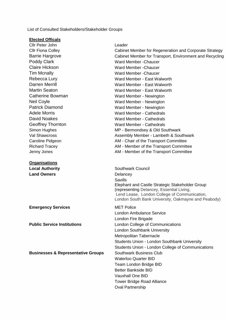
List of Consulted Stakeholders/Stakeholder Groups
Elected Officals Cllr Peter John Leader Cllr Fiona Colley Cabinet Member for Regeneration and Corporate Strategy Barrie Hargrove Cabinet Member for Transport, Environment and Recycling Poddy Clark Ward Member -Chaucer Claire Hickson Ward Member -Chaucer Tim Mcnally Ward Member -Chaucer Rebecca Lury Ward Member - East Walworth Darren Merrill Ward Member - East Walworth Martin Seaton Ward Member - East Walworth Catherine Bowman Ward Member - Newington Neil Coyle Ward Member - Newington Patrick Diamond Ward Member - Newington Adele Morris Ward Member - Cathedrals David Noakes Ward Member - Cathedrals Geoffrey Thornton Ward Member - Cathedrals Simon Hughes MP - Bermondsey & Old Southwark Val Shawcross Assembly Member - Lambeth & Southwark Caroline Pidgeon AM - Chair of the Transport Committee Richard Tracey AM - Member of the Transport Committee Jenny Jones AM - Member of the Transport Committee
Organisations Local Authority Southwark Council Land Owners Delancey
Savills Elephant and Castle Strategic Stakeholder Group (representing Delancey, Essential Living, Lend Lease, London College of Communication, London South Bank University, Oakmayne and Peabody)
Emergency Services MET Police London Ambulance Service London Fire Brigade
Public Service Institutions London College of Communications London Southbank University Metropolitan Tabernacle Students Union - London Southbank University Students Union - London College of Communications
Businesses & Representative Groups Southwark Business Club Waterloo Quarter BID Team London Bridge BID Better Bankside BID Vauxhall One BID Tower Bridge Road Alliance Oval Partnership
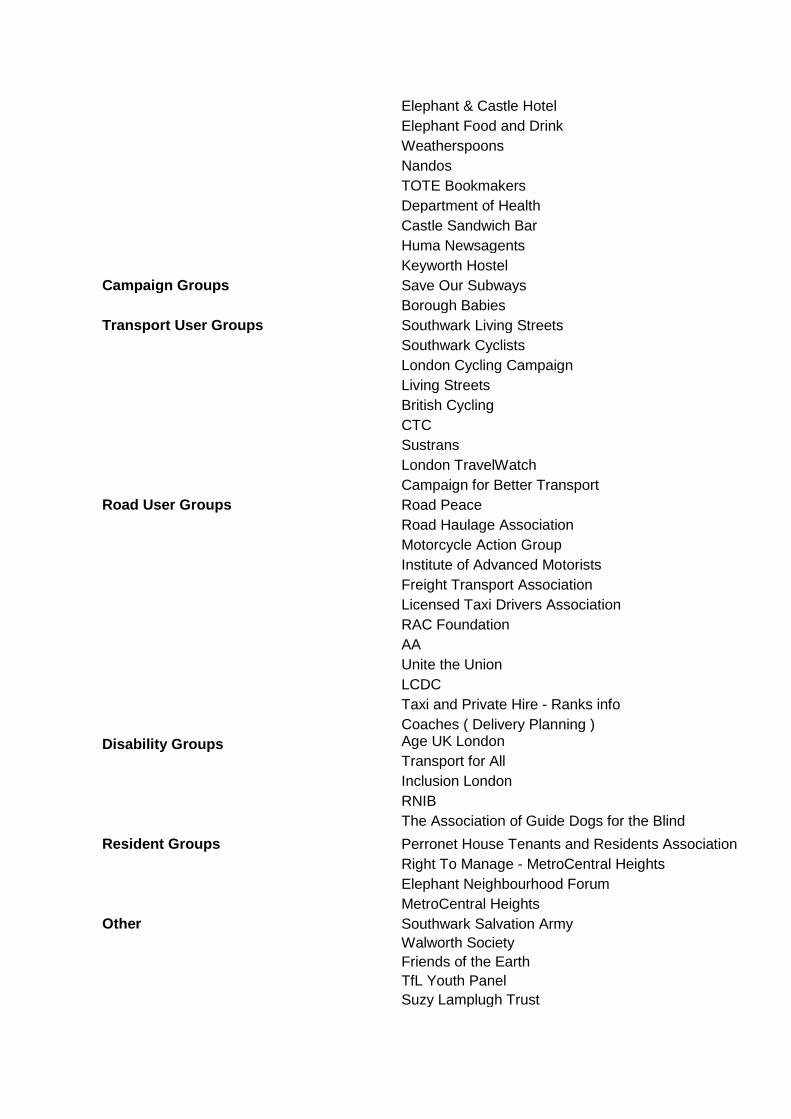
Elephant & Castle Hotel
Elephant Food and Drink
Weatherspoons
Nandos
TOTE Bookmakers
Department of Health
Castle Sandwich Bar
Huma Newsagents
Keyworth Hostel
Campaign Groups Save Our Subways
Borough Babies
Transport User Groups Southwark Living Streets
Southwark Cyclists
London Cycling Campaign
Living Streets
British Cycling
CTC
Sustrans
London TravelWatch
Campaign for Better Transport
Road User Groups Road Peace
Road Haulage Association
Motorcycle Action Group
Institute of Advanced Motorists
Freight Transport Association
Licensed Taxi Drivers Association
RAC Foundation
AA
Unite the Union
LCDC
Taxi and Private Hire - Ranks info
Coaches ( Delivery Planning )
Disability Groups Age UK London
Transport for All
Inclusion London
RNIB
The Association of Guide Dogs for the Blind
Resident Groups Perronet House Tenants and Residents Association
Right To Manage - MetroCentral Heights
Elephant Neighbourhood Forum
MetroCentral Heights
Other Southwark Salvation Army
Walworth Society
Friends of the Earth
TfL Youth Panel
Suzy Lamplugh Trust
Appendix B
FREEPOST TFL C
ON
SULTATIO
NS
Privacy noticeTransport for London (TfL), its subsidiaries and service providers, and the G
reater London Authority will
use your personal information for the purpose of adm
inistering this consultation and assessing opinions on the proposed changes to the Elephant & Castle N
orthern Roundabout. Your personal information w
ill be properly safeguarded and processed in accordance w
ith the requirements of the Data Protection Act 1998.
Responses to the consultation may be m
ade publically available, but any personal information w
ill be kept confidential. You do not have to provide any personal inform
ation, but this information m
ay help TfL to understand the range of responses. For exam
ple, responses may by analysed by postcode to
help identify local issues.
Printed on recycled paper
On transforming Elephant & Castle
Spring 2014
Have your say

Objectives of the scheme
There is a clear case for radical changes at the northern roundabout. We want to reduce the impact traffic has on the area and make it more attractive while also improving facilities for all road users.
Our proposals include the removal of the roundabout and creation of a major new public space. This will transform the area for those who live, work and travel in Elephant & Castle. The changes will balance the needs of drivers more evenly with those of pedestrians and cyclists.
Background
One of London’s biggest regeneration projects is planned for Elephant & Castle. We are working with the Greater London Authority, Southwark Council and local developers to transform Elephant & Castle and would like to hear your views on our plans.
1
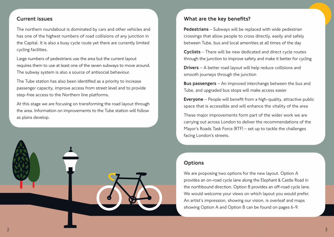
Current issues
The northern roundabout is dominated by cars and other vehicles and has one of the highest numbers of road collisions of any junction in the Capital. It is also a busy cycle route yet there are currently limited cycling facilities.
Large numbers of pedestrians use the area but the current layout requires them to use at least one of the seven subways to move around. The subway system is also a source of antisocial behaviour.
The Tube station has also been identified as a priority to increase passenger capacity, improve access from street level and to provide step-free access to the Northern line platforms.
At this stage we are focusing on transforming the road layout through the area. Information on improvements to the Tube station will follow as plans develop.
What are the key benefits?
Pedestrians – Subways will be replaced with wide pedestrian crossings that allow people to cross directly, easily and safely between Tube, bus and local amenities at all times of the day
Cyclists – There will be new dedicated and direct cycle routes through the junction to improve safety and make it better for cycling
Drivers – A better road layout will help reduce collisions and smooth journeys through the junction
Bus passengers – An improved interchange between the bus and Tube, and upgraded bus stops will make access easier
Everyone – People will benefit from a high-quality, attractive public space that is accessible and will enhance the vitality of the area
These major improvements form part of the wider work we are carrying out across London to deliver the recommendations of the Mayor’s Roads Task Force (RTF) – set up to tackle the challenges facing London’s streets.
Options
We are proposing two options for the new layout. Option A provides an on-road cycle lane along the Elephant & Castle Road in the northbound direction. Option B provides an off-road cycle lane. We would welcome your views on which layout you would prefer. An artist’s impression, showing our vision, is overleaf and maps showing Option A and Option B can be found on pages 6-9.
2 3
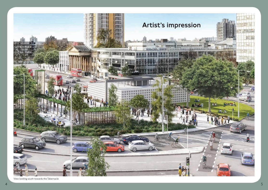
Artist’s impression
View looking south towards the Tabernacle
4 5
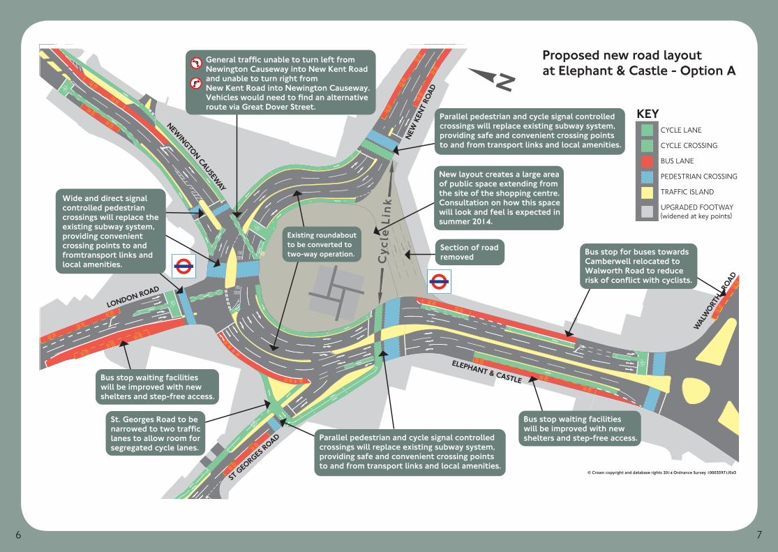
STOP
BUS
STOP
BUS
STOP
BUS
STOPBUS
STOPBUS
STOPBUS
STOPBUS
STOPBUS
STOP BUS
STOP BUS
STOPBUS
STOPBUS
STOPBUS
STOPBUS
STOPBUS
STOPBUS
STOPBUS
STOPBUS
STOPBUS
STOPBUSSTOPBUSSTOPBUS
STOP BUS STOP BUS
BUS
ONLY
AND
BUS LANEAND
STOPBUS
STOPBUS
STOPBUS
STOPBUS
STOPBUS
STOPBUS
BUSESONLY
BUSESONLY
LONDON ROAD
ELEPHANT & CASTLE
WAL
WORT
H R
OAD
ST GEO
RGES ROAD
NEW
KEN
T RO
AD
NEWINGTON CAUSEW
AY
Cyc
le L
ink
Parallel pedestrian and cycle signal controlledcrossings will replace existing subway system,providing safe and convenient crossing pointsto and from transport links and local amenities.
General traffic unable to turn left fromNewington Causeway into New Kent Roadand unable to turn right fromNew Kent Road into Newington Causeway.Vehicles would need to find an alternativeroute via Great Dover Street.
Section of roadremoved
Wide and direct signalcontrolled pedestrian crossings will replace the existing subway system, providing convenientcrossing points to and fromtransport links and local amenities.
St. Georges Road to benarrowed to two trafficlanes to allow room forsegregated cycle lanes.
Bus stop waiting facilitieswill be improved with newshelters and step-free access.
Parallel pedestrian and cycle signal controlledcrossings will replace existing subway system,providing safe and convenient crossing pointsto and from transport links and local amenities.
Existing roundaboutto be converted totwo-way operation.
New layout creates a large areaof public space extending fromthe site of the shopping centre.Consultation on how this spacewill look and feel is expected insummer 2014.
Bus stop for buses towardsCamberwell relocated toWalworth Road to reducerisk of conflict with cyclists.
Bus stop waiting facilitieswill be improved with newshelters and step-free access.
Proposed new road layoutat Elephant & Castle - Option A
KEYCYCLE LANE
CYCLE CROSSING
BUS LANE
PEDESTRIAN CROSSING
TRAFFIC ISLAND
UPGRADED FOOTWAY(widened at key points)
© Crown copyright and database rights 2014 Ordnance Survey 100035971/043
6 7
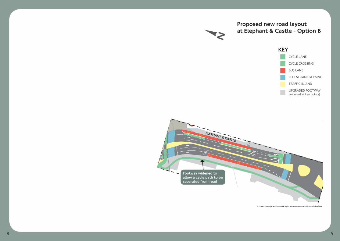
STOP
BUS
STOP
BUS
STOP
BUS
STOPBUS
STOPBUS
STOPBUS
STOPBUS
STOPBUS
STOP BUS
STOP BUS
STOPBUS
STOPBUS
STOPBUS
STOPBUS
STOPBUS
STOPBUS
STOPBUS
STOPBUS
STOPBUS
STOPBUSSTOPBUSSTOPBUS
STOP BUS STOP BUS
BUS
ONLY
AND
BUS LANEAND
STOPBUS
STOPBUS
STOPBUS
STOPBUS
STOPBUS
STOPBUS
BUSESONLY
BUSESONLY
LONDON ROAD
ELEPHANT & CASTLE
WAL
WORT
H R
OAD
ST GEO
RGES ROAD
NEW
KEN
T RO
AD
NEWINGTON CAUSEW
AY
Cyc
le L
ink
New layout creates a large areaof public space extending fromthe site of the shopping centre.Consultation on how this spacewill look and feel is expected insummer 2014.
Parallel pedestrian and cycle signal controlledcrossings will replace existing subway system,providing safe and convenient crossing pointsto and from transport links and local amenities.
Existing roundaboutto be converted totwo-way operation.
Bus stop waiting facilitieswill be improved with newshelters and step-free access.
General traffic unable to turn left fromNewington Causeway into New Kent Roadand unable to turn right fromNew Kent Road into Newington Causeway.Vehicles would need to find an alternativeroute via Great Dover Street.
Bus stop for buses towardsCamberwell relocated toWalworth Road to reducerisk of conflict with cyclists.
Section of roadremoved
Wide and direct signalcontrolled pedestrian crossings will replace the existing subway system, providing convenientcrossing points to and fromtransport links and local amenities.
St. Georges Road to benarrowed to two trafficlanes to allow room forsegregated cycle lanes.
Parallel pedestrian and cycle signal controlledcrossings will replace existing subway system,providing safe and convenient crossing pointsto and from transport links and local amenities.
Bus stop waiting facilitieswill be improved with newshelters and step-free access.
Footway widened toallow a cycle path to beseparated from road
Proposed new road layoutat Elephant & Castle - Option B
KEYCYCLE LANE
CYCLE CROSSING
BUS LANE
PEDESTRIAN CROSSING
TRAFFIC ISLAND
UPGRADED FOOTWAY(widened at key points)
© Crown copyright and database rights 2014 Ordnance Survey 100035971/043
8 9
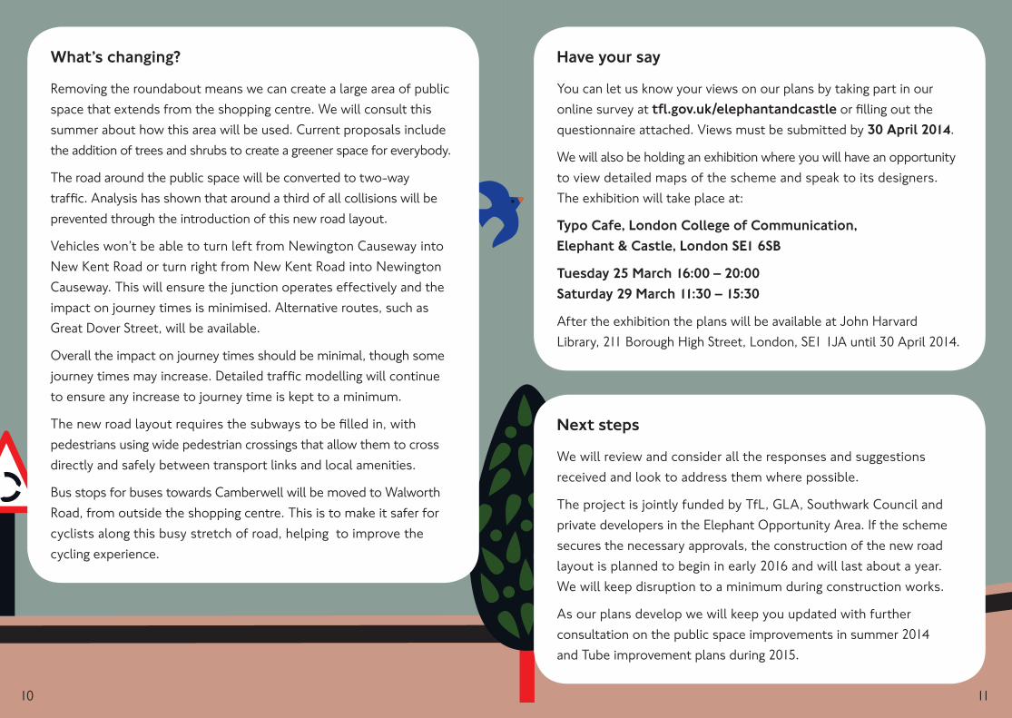
Have your say
You can let us know your views on our plans by taking part in our online survey at tfl.gov.uk/elephantandcastle or filling out the questionnaire attached. Views must be submitted by 30 April 2014.
We will also be holding an exhibition where you will have an opportunity to view detailed maps of the scheme and speak to its designers. The exhibition will take place at:
Typo Cafe, London College of Communication, Elephant & Castle, London SE1 6SB
Tuesday 25 March 16:00 – 20:00 Saturday 29 March 11:30 – 15:30
After the exhibition the plans will be available at John Harvard Library, 211 Borough High Street, London, SE1 1JA until 30 April 2014.
Next steps
We will review and consider all the responses and suggestions received and look to address them where possible.
The project is jointly funded by TfL, GLA, Southwark Council and private developers in the Elephant Opportunity Area. If the scheme secures the necessary approvals, the construction of the new road layout is planned to begin in early 2016 and will last about a year. We will keep disruption to a minimum during construction works.
As our plans develop we will keep you updated with further consultation on the public space improvements in summer 2014 and Tube improvement plans during 2015.
What’s changing?
Removing the roundabout means we can create a large area of public space that extends from the shopping centre. We will consult this summer about how this area will be used. Current proposals include the addition of trees and shrubs to create a greener space for everybody.
The road around the public space will be converted to two-way traffic. Analysis has shown that around a third of all collisions will be prevented through the introduction of this new road layout.
Vehicles won’t be able to turn left from Newington Causeway into New Kent Road or turn right from New Kent Road into Newington Causeway. This will ensure the junction operates effectively and the impact on journey times is minimised. Alternative routes, such as Great Dover Street, will be available.
Overall the impact on journey times should be minimal, though some journey times may increase. Detailed traffic modelling will continue to ensure any increase to journey time is kept to a minimum.
The new road layout requires the subways to be filled in, with pedestrians using wide pedestrian crossings that allow them to cross directly and safely between transport links and local amenities.
Bus stops for buses towards Camberwell will be moved to Walworth Road, from outside the shopping centre. This is to make it safer for cyclists along this busy stretch of road, helping to improve the cycling experience.
10 11
Contact details
Website: tfl.gov.uk/elephantandcastle
Email: [email protected]
Post: FREEPOST TFL CONSULTATIONS
Tel: 0343 222 1234* *Service and Network charges may apply.
Reply Form
Please complete the questionnaire and return it to us at the Freepost address overleaf by 30 April 2014. Or alternatively complete the online questionnaire at tfl.gov.uk/elephantandcastle .
To seal the envelope, wet the gum strip, fold along the dotted line overleaf and press down. If you need more space please enclose an additional sheet of paper.
12
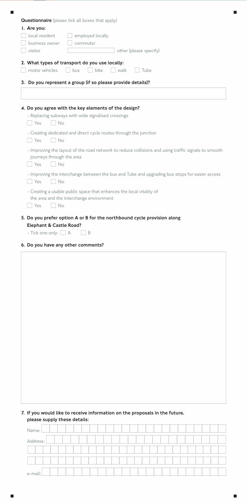
Questionnaire (please tick all boxes that apply)1. Are you: local resident employed locally
business owner commuter visitor other (please specify)
2. What types of transport do you use locally: motor vehicles bus bike walk Tube
3. Do you represent a group (if so please provide details)?
4. Do you agree with the key elements of the design? - Replacing subways with wide signalised crossings Yes No
- Creating dedicated and direct cycle routes through the junction Yes No
-Improvingthelayoutoftheroadnetworktoreducecollisionsandusingtrafficsignalstosmoothjourneys through the area
Yes No
- Improving the interchange between the bus and Tube and upgrading bus stops for easier access Yes No
- Creating a usable public space that enhances the local vitality of the area and the interchange environment
Yes No
5. Do you prefer option A or B for the northbound cycle provision along Elephant & Castle Road?
- Tick one only: A B
6. Do you have any other comments?
7. If you would like to receive information on the proposals in the future, please supply these details:
Name:
Address:
e-mail:
Background
One of London’s biggest regeneration projects is planned for
Elephant & Castle. We are w
orking with the G
reater London Authority, Southw
ark Council and local developers to transform
Elephant & Castle and would like to hear your view
s on our plans.
FREEPOST TFL CONSULTATIONS
Privacy noticeTransport for London (TfL), its subsidiaries and service providers, and the Greater London Authority will use your personal information for the purpose of administering this consultation and assessing opinions on the proposed changes to the Elephant & Castle Northern Roundabout. Your personal information will be properly safeguarded and processed in accordance with the requirements of the Data Protection Act 1998.
Responses to the consultation may be made publically available, but any personal information will be kept confidential. You do not have to provide any personal information, but this information may help TfL to understand the range of responses. For example, responses may by analysed by postcode to help identify local issues.
Prin
ted
on re
cycl
ed p
aper
On
tran
sfor
min
g El
epha
nt &
Cas
tle
Sprin
g 20
14
Hav
e yo
ur s
ay

Appendix C
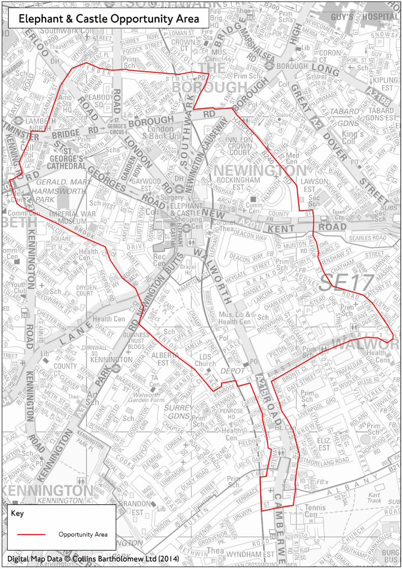

Appendix D
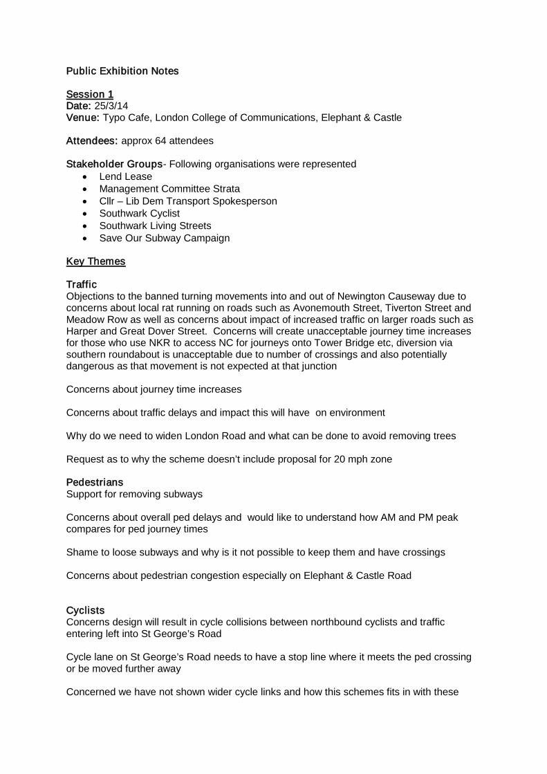
Public Exhibition Notes Session 1 Date: 25/3/14 Venue: Typo Cafe, London College of Communications, Elephant & Castle Attendees: approx 64 attendees Stakeholder Groups- Following organisations were represented
• Lend Lease • Management Committee Strata • Cllr – Lib Dem Transport Spokesperson • Southwark Cyclist • Southwark Living Streets • Save Our Subway Campaign
Key Themes Traffic Objections to the banned turning movements into and out of Newington Causeway due to concerns about local rat running on roads such as Avonemouth Street, Tiverton Street and Meadow Row as well as concerns about impact of increased traffic on larger roads such as Harper and Great Dover Street. Concerns will create unacceptable journey time increases for those who use NKR to access NC for journeys onto Tower Bridge etc, diversion via southern roundabout is unacceptable due to number of crossings and also potentially dangerous as that movement is not expected at that junction Concerns about journey time increases Concerns about traffic delays and impact this will have on environment Why do we need to widen London Road and what can be done to avoid removing trees Request as to why the scheme doesn’t include proposal for 20 mph zone Pedestrians Support for removing subways Concerns about overall ped delays and would like to understand how AM and PM peak compares for ped journey times Shame to loose subways and why is it not possible to keep them and have crossings Concerns about pedestrian congestion especially on Elephant & Castle Road Cyclists Concerns design will result in cycle collisions between northbound cyclists and traffic entering left into St George’s Road Cycle lane on St George’s Road needs to have a stop line where it meets the ped crossing or be moved further away Concerned we have not shown wider cycle links and how this schemes fits in with these
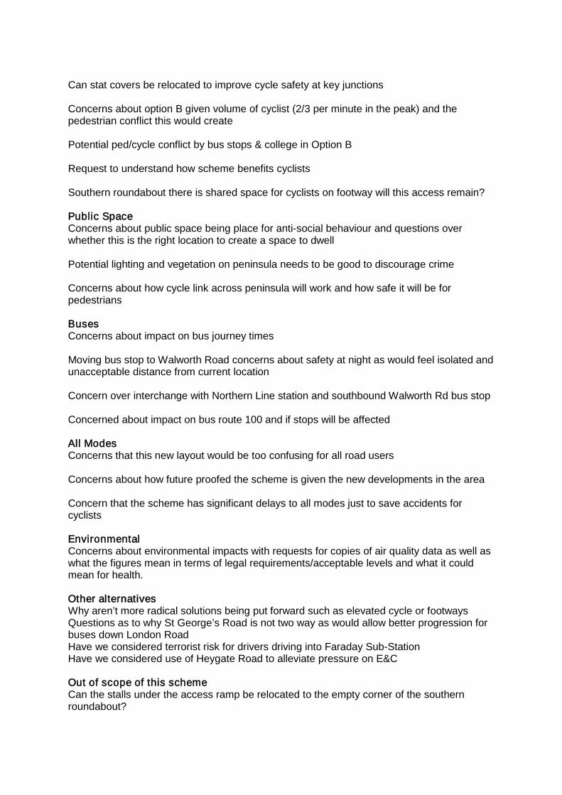
Can stat covers be relocated to improve cycle safety at key junctions Concerns about option B given volume of cyclist (2/3 per minute in the peak) and the pedestrian conflict this would create Potential ped/cycle conflict by bus stops & college in Option B Request to understand how scheme benefits cyclists Southern roundabout there is shared space for cyclists on footway will this access remain? Public Space Concerns about public space being place for anti-social behaviour and questions over whether this is the right location to create a space to dwell Potential lighting and vegetation on peninsula needs to be good to discourage crime Concerns about how cycle link across peninsula will work and how safe it will be for pedestrians Buses Concerns about impact on bus journey times Moving bus stop to Walworth Road concerns about safety at night as would feel isolated and unacceptable distance from current location Concern over interchange with Northern Line station and southbound Walworth Rd bus stop Concerned about impact on bus route 100 and if stops will be affected All Modes Concerns that this new layout would be too confusing for all road users Concerns about how future proofed the scheme is given the new developments in the area Concern that the scheme has significant delays to all modes just to save accidents for cyclists Environmental Concerns about environmental impacts with requests for copies of air quality data as well as what the figures mean in terms of legal requirements/acceptable levels and what it could mean for health. Other alternatives Why aren’t more radical solutions being put forward such as elevated cycle or footways Questions as to why St George’s Road is not two way as would allow better progression for buses down London Road Have we considered terrorist risk for drivers driving into Faraday Sub-Station Have we considered use of Heygate Road to alleviate pressure on E&C Out of scope of this scheme Can the stalls under the access ramp be relocated to the empty corner of the southern roundabout?
General interest in Northern line station proposals, shopping centre, and to a lesser extent N-S superhighway Consultation Issues Concerns with use of CGIs with claims that they are misleading (and questioning use of angles used) and only plan views should be used Session 2 Date: 29/3/14 Venue: Typo Cafe, London College of Communications, Elephant & Castle Staffed By: Will Miller, Carlo Romano, Gary Ward, and Emma Crittenden from TfL, Jon Abbot from Southwark Council and Kim Humphries representing Delancey Attendees: approx 63 attendees Stakeholder Groups- Following organisations were represented
• Simon Hughes MP • Metro Central Heights • Southwark Living Streets • Save Our Subway Campaign
Key Themes A number of people supported the proposals. Of those that didn’t key concerns were as follows: Traffic Objections to the banned turning movements into and out of Newington Causeway due to concerns about local rat running on roads such as Avonmouth Street, Tiverton Street and Meadow Row as well as concerns about impact of increased traffic on larger roads such as Harper Street and Great Dover Street. Concerns will create unacceptable journey time increases for those who use NKR to access Tesco southbound and NC northbound for journeys onto Tower Bridge etc, diversion via southern roundabout is unacceptable due to number of crossings and also potentially dangerous as that movement is not expected at that junction Concerns about suggested diversion route and the practicalities of large vehicles using Gt Dover Street/Borough High Street junction as large vehicles will get stuck as very tight turns. Concerns about journey time increases and that this will encourage rat running in the wider area as cars avoid the junction Concerns that despite traffic modelling the right turn pocket into St George’s Road won’t work and will result in bad queues. Can the lights at New Kent Road be split so that cycles and buses have own stage? Concerns about traffic delays and impact this will have on environment Why do we need to widen London Road and what can be done to avoid removing trees Request as to why the scheme doesn’t include proposal for 20 mph zone
Pedestrians Both support and opposition for removing subways Requests to reduce wait time for pedestrians at crossings. Pedestrian double cycling should be achieved if possible. Concerns over pedestrian congestion outside Bakerloo Line station – there is a need to rationalise trees/bus stops/telephone boxes. Concern that ped modelling of Newington Causeway crossing had unrealistically low numbers Concerns that will create more pedestrian collision as people cross at risk or are confused by layout and cross when they shouldn’t Shame to loose subways and why is it not possible to keep them and have crossings Concerns about pedestrian congestion especially on Elephant & Castle Road Cyclists Concerns design will result in cycle collisions between northbound cyclists and traffic entering left into St George’s Road Design does not go far enough – there should be segregated cycling provision around the whole roundabout Could cyclists have a separate cycle stage northbound on E&C Road? Concerns that cyclist waiting to turn right into London Road will not get sufficient time to turn right before Newington Causeway starts moving. Concerns that off-carriageway provision in Option B would not be used by majority of cyclists. Could we move the cycle lane on St George’s Road to the south side? Can a cycle lane be provided alongside the bus lane heading towards London Road? Against segregated cycle lanes as it restrains movement and cyclists likely to carry on using main carriageway Request to allow cyclists to left turn at Newington Causeway Concerned we have not shown wider cycle links and how this scheme fits in with these Potential ped/cycle conflict by bus stops & college in Option B Public Space Concerns about public space being place for anti-social behaviour and questions over whether this is the right location to create a space to dwell. Currently already many problems with homeless people and clubbers urinating and vomiting – how will this be designed out in new scheme? Area outside Metro Central Heights is a particular concern. Potential lighting and vegetation on peninsula needs to be good to discourage crime
Concerns about how cycle link across peninsula will work and how safe it will be for pedestrians Buses Concerns about impact on bus journey times Moving bus stop to Walworth Road concerns about safety at night as would feel isolated and unacceptable distance from current location Concern over interchange with Northern Line station and southbound Walworth Rd bus stop All Modes Recognition that this scheme would alleviate congestion issues on southbound E&C Link Road Concerns that this new layout would be too confusing for all road users Environmental Concerns about environmental impacts with requests for copies of air quality data as well as what the figures mean in terms of legal requirements/acceptable levels and what it could mean for health. Other alternatives Why aren’t more radical solutions being put forward such as elevated cycle or footways? Have we considered using Heygate Street to link cyclist from Walworth Road to New Kent Road? Out of scope of this scheme General interest in Northern line station proposals, shopping centre, and to a lesser extent N-S superhighway Need to improve parallel cycle routes to encourage more cyclists away from E&C What can be done to reduce speeding on St Georges Road General dis-satisfaction with operation of Southern Roundabout Consultation Issues Criticism that map was not clear enough for people to be able to understand how they would move round the new junction

Appendix E
Elephant & Castle Northern Roundabout
Proposed new road layout at Elephant and Castle
Response to issues raised
August 2014
Transport for London’s response to main issues raised during consultation The proposed works at Elephant & Castle should reduce the impact traffic has on the area, by making it more attractive and balancing the needs of motorists with those of pedestrians and cyclists. It is anticipated that accidents will fall by 33 per cent after the changes have been implemented. Over 80 per cent of members of the public that responded to the consultation stated they supported the key elements of the design and 53 per cent supported Option B (34 per cent supported Option A and 13 per cent did not answer the question). Concerns were raised over the impact of the changes on all users including cyclists, drivers, pedestrians, bus users and also people interchanging with other public transport modes. For some users there will be potential impacts, such as increased journey times, but Transport for London (TfL) feels that these impacts are fairly balanced out, and that the overall improvements justify these impacts. This report records TfL’s responses to the main issues that respondents raised during the consultation, outlining why decisions have been made and how they are justified, as well as explaining where we have been able to make changes to the design in response to issues raised. Cycling related issues Concerns design needs to do more to resolve cycling conflicts A particular area of concern was left hook conflicts between cyclists and traffic, especially at the St Georges Road junction. This was noted as a problem in the Option A proposal but some respondents also felt many cyclists may choose to stay on the carriageway and therefore would also be an issue under Option B. We have decided to progress with Option B with some modifications (these are explored further in the report). Option B was the most popular choice from respondees and we feel it offers the best protection against left hook risk as cyclists can choose to be off carriageway. We will look at a number of options to minimise cycle/pedestrian conflict as this was raised as a particular issue with Option B. We recognise that some cyclists will wish to remain on the carriageway and we will be considering potential improvements such as:
• Widening the carriageway northbound on the Elephant and Castle Link Road to allow for a 4.5 metre bus lane to offer space for cyclists to overtake buses
2

• Introducing a new cycle feeder lane on the approach to St Georges Road to offer protection to cyclists approaching the junction
• We are also considering introducing a 20mph zone, which will lower traffic speeds and improve conditions for cyclists
We were asked to consider signalising the St Georges Road junction but this would not be possible, as it would adversely affect the operation of the junction leading to increased journey times for all modes of traffic and unacceptable queuing through the area. We also considered banning the turn into St Georges Road but this was shown to have a significant adverse impact on the surrounding road network.
It is impossible to design out all possible cycle/traffic conflicts. Providing off carriageway provision is the best option given the constraints of the junction and the need to maintain traffic flows along this key arterial route and the Inner Ring Road. Our proposal offers much better protection to cyclists than the current situation. It should, however, be noted that for cyclists wishing to minimise cycle/traffic conflicts then the safest option will be for them to utilise the off carriageway provision, Cycle Superhighway 7 or the proposed bypass through the redeveloped Heygate Estate to the east.
Respondents were also concerned about the interaction between buses and cyclists at bus stops and called on us to provide more bus stop bypasses, as proposed northbound on Newington Causeway.
We recognise cycle conflicts at bus stops are an issue, particularly where cyclists are required to negotiate a long bus cage which a number of buses can serve at the same time. Under our current proposals cyclist will have the off carriageway option northbound on the Elephant and Castle Link Road to avoid this situation and southbound we are considering relocating the busier stop to the Walworth Road to improve conditions there.
On London Road, due to space constrictions it has not been possible to re-locate stops or provide an off carriageway facility. However a new North/South Cycle Super Highway is proposed for St Georges Road. It’s envisaged that the number of cyclist using London Road will significantly reduce in favour of the better cycling facilities on St Georges Road.
Although a bus stop by-pass will be provided southbound on Newington Causeway, space restrictions mean it is not possible to provide this provision northbound. Similar space constraints rule this out as an option for the bus stops on New Kent Road and Walworth Road.
Respondents were concerned about the lack of protected space for cyclists southbound on the Elephant and Link Road, and with the use of kerbs bordering the cycle lane. We have revisited our plans for the provision southbound. Instead of the cycle lane with segregated kerb line, we will widen the bus lane to 4.5m and will use
3
road markings to minimise the points at which buses can pull out of the bus lane. This will make potential conflict points clearer to cyclists and allow more room for cyclists to negotiate and pass buses away from general traffic lanes. In addition, we are still considering moving the bus stop serving routes towards Camberwell to the north of the Walworth Road. This would result in a considerable reduction in the number of buses for cyclists to pass. We recognise that conflict would still exist where cyclists exit the bus lane to enter the feeder lane to the advanced stop line. However, this is the same as the existing situation and no accidents have been identified under this arrangement.
There were a number of calls for an off carriageway provision southbound either on the footway or utilising the central reservation. However, current space constraints mean this is not an option. We will continue to work with the LB Southwark and the new shopping centre owners to see if it is possible to gain further footway width as part of the redevelopment of the shopping centre. This would allow the cycling provision to be re-assessed in the future, and improve bus stop waiting conditions.
Some respondents were concerned about the London Road junction, where southbound cyclists would need to negotiate two lanes of traffic to access the cycle lane/ASL. There were also concerns about the safety of the right turn into London Road for cyclists heading northbound. To address concerns about the right turn movement into London Road, we will provide a two stage cycle crossing which will enable cyclists to cross the carriageway in parallel and on the same signal phase as the pedestrians. In addition, cyclists wishing to turn right will be able to wait in the protective pocket. We have also revisited our plans to widen London Road; through more advanced modelling of the operation of the signals we are able to reduce it from four to three traffic lanes. This means cyclists will now only have to negotiate one left turn lane on the approach to the junction.
Further cycle lane improvements There were concerns about the lack of continuity of cycle lane provision and that the proposals were overly complicated. However, opinion was divided as to whether off or on carriageway provision is preferred. There were also specific requests for further cycle lane provision between St George’s Road and Newington Causeway, cycle lanes on London Road and New Kent Road and a cycle lane to allow left turns from Newington Causeway into New Kent Road.
We are committed to transformational change at the northern roundabout. At the heart of this is a desire to improve cycle safety and we feel our proposals offer a marked improvement in the provision of cycling facilities through the junction. However, it is important to understand the constraints in place at this junction, both in terms of space and traffic capacity. For example:
• The narrow footway widths in many areas limit off carriageway options
4
• We cannot move the Faraday Memorial because it contains a London Underground electrical sub-station and the cost of re-location is prohibitive
• The junction is a key node on London’s inner ring road so it is imperative to manage the impact on road network capacity
• It is a key bus corridor with very high numbers of buses using the junction, so journey time impacts need to be managed
These constraints present a number of challenges to delivering improvements for cyclists. However, we feel our plans provide the best balance between different user groups of the junction and where space has allowed we have worked to ensure consistency of approach. For example, with the exception of St George’s Road, the other approaches have with flow cycle facilities and the cycle lanes are segregated, with the exception of the southbound Link Road cycle lane and a short stretch between St George’s Road and Newington Causeway.
Following requests, we investigated adding an additional off carriageway cycle lane from St Georges Road to London Road to provide a more continuous provision. Unfortunately, the traffic modelling demonstrated that this was not a viable option because the footway would need to be widened to accommodate an off carriageway cycle lane which would require the removal of the bus lane. This proved to be unworkable due to the volume of left turning buses; under this layout, buses would create bus queues which would block the flow of vehicles through the wider junction. We will therefore need to maintain the original plan for a shared bus and cycle lane. This will have journey time benefits for cyclists as the off carriageway provision would have required an additional cycle signal phase.
It is not possible to provide cycle lanes on London Road and New Kent Road due to insufficient space. In the case of London Road, this would involve using carriageway space and initial assessments show the impact on buses would be too severe to be acceptable. On New Kent Road, the railway bridge and bus stops means there is not adequate width to provide a cycle lane.
There were also requests for a cycle lane to facilitate the left turn movement of cyclists from Newington Causeway into New Kent Road. We investigated re-instating the left turn for cycles from Newington Causeway into New Kent Road with an individual cycle signal phase. However, the impacts to the operation of the junction were too great. As such, we will propose a ‘shared space’ provision on the footway or a local cycle track by-pass to the traffic lights, to facilitate the eastbound cycling movement. This will be explored further as part of the urban realm design. However, cyclists are encouraged to use the bypass through Avonmouth Street and Meadow Row to make this movement.
There were a number of concerns noted about the safety of shared bus and cycle lanes, and about the safety of cycle lanes positioned between bus and traffic lanes. Almost all bus lanes in London permit cycles into them and this shared use is very
5
common place and considered a safe arrangement. The revision to the design now means most instances of cycle lanes between bus and traffic lanes have been removed.
The width of the cycle lanes was raised, with requests for 2.5m width to ensure adequate protection, to allow cyclist to overtake, and to ensure capacity for likely cycle flows. The current proposal is for 2m wide cycle lanes. This is a standard design width and is considered sufficient for cyclists to overtake one another. Where space allows we will look to increase this to 2.5m but this will not be possible in all circumstances.
Requests were made to re-visit the cycling provision at the southern junction and to make improvements to the current bypass to encourage better usage. This is in addition to requests for Elephant Road to be used as an eastern bypass option.
The new layout was put in place at the southern roundabout in May 2011. In the 32 months since then, the period for which data is available, there has been a 77 per cent reduction in accidents involving cyclists. This data excludes the tragic death of a cyclist in May 2014. Nonetheless, we are considering some adjustments to the cycle provision and now the proposed design for the northern roundabout has been confirmed, these can be progressed further. Please note that they remain separate to the work on the northern roundabout.
We feel our plans offer a marked improvement in the provision of cycling facilities through the junction. However, we are also committed to working with Southwark Council to improve and develop alternative cycling routes that allow cyclists to bypass the junction. We are working together to look at how we can make them quicker and more direct as well as reviewing the signage to encourage better use of the bypass options to avoid the junction. The alternative links will be further enhanced by the delivery of the new north south cycle superhighway with segregated cycle lanes on St George's and Blackfriars Roads. Attached in appendix J is a map which details how the northern roundabout relates to the alternative cycle routes, both existing and proposed including the proposed segregated North South Cycle Superhighway. The option of using Elephant Road as an eastern bypass is still under review as part of the Heygate Estate Masterplan and needs to be considered alongside plans for the re-development of the shopping centre site.
Option B We recognise that respondents raised a number of issues with the plans for the Elephant and Castle Link Road proposed in Option B, the option we are now progressing with. The most common issue was concern about how pedestrian/cycle conflict would be managed. Other issues included whether confident cyclists would find it too slow and indirect; whether the cycle lane widths would be sufficient to cope with likely cycle flows; and whether it could be made two way to improve the situation for southbound cyclists.
6
We will explore a number of options to manage pedestrian and cycle conflict. These will be looked at in more detail as part of the urban realm design but will include giving special consideration to the types of materials used as a method of alerting pedestrians and cyclists to look out for one other. Examples include using contrasting colours/materials to demarcate crossing points, marginally sinking the cycle lane into the footway, or using up-stands to draw pedestrians’ attention to the cycle lane. As the majority of pedestrian movements on the link road are from the crossing to the bus stops, we will consider installing the new bus shelters, or other measures such as planters, along one edge of the cycle path to act as a barrier. We will also widen the footway outside the Tabernacle to create more space for pedestrians and bus passengers. We will also consider signage to advise both pedestrians and cyclists of the need to respect each other in when in close proximity.
We appreciate that a number of cyclists will wish to remain on carriageway regardless of the quality of the off carriageway provision. However, we are widening the cycle crossing at St Georges Road to increase capacity in order to maximise throughput of cycles at the green phase to minimise the cycle journey times. Additionally, the entry point for the off carriageway provision will allow cyclists to bypass both the signals at the southern junction and the pedestrian crossing south of St Georges Road, which may be considered beneficial. We are also exploring implementing a 20mph limit through the junction. This could help to regulate traffic speeds and improve overall safety conditions for all users of the junction.
Unfortunately, the space constraints mean it is not possible to implement a two way cycle lane. The proposed cycle lane will be two metres wide, which is the same width as the segregated cycling facilities that are being introduced elsewhere. This is wider than many cycle lanes in London, and because cyclists will also have access to the 4.5m wide bus lane there is in effect greater capacity.
Concerns about cycling and pedestrian conflict In addition, to the concerns raised about cycling/pedestrian conflict in Option B, the other area of concern is the proposed cycle link across the peninsula. This will also be looked at in more detail as part of the urban realm designs which will be consulted on later in the year. However, if we proceed with the link, similar measures to those identified above may be considered to ensure cycle speeds are not excessive and clear demarcation will be utilised to ensure inter-visibility is maintained and that respective spaces are respected. Alternative proposals We received two detailed counter proposals for the cycling facilities. One from Southwark Cyclists (in conjunction with the London Cycling Campaign) and one from a blogger known as ‘Maidstoneonbike’ which several respondents asked us to consider.
7
The proposal from Southwark Cyclists comprises a single large signal-controlled crossroads junction near the Bakerloo Line Ticket Hall. There is also a separate junction to allow turning movements into St Georges Road.
Some of the principles of the design are similar to the southern peninsula proposal, such as combining turning movements into a single junction and the right turn into St Georges Road operating in the ‘shadow’ of the nearby pedestrian crossing, however the design raises a number of areas of concern which render it unworkable. These are summarised below:
1. The design has not been subject to detailed traffic modelling but TfL has given due consideration to the proposal, optimising the design in the absence of detailed design and modelling information. This has shown the main junction would need a minimum of five signal stages (4 for traffic and an ‘all-red’ pedestrian phase) to allow all traffic movements to take place safely. This decreases the journey time efficiency of the proposal and subsequent impact on the surrounding network
2. The five-stage signal phasing does not include the potential inclusion of
separately/advanced signalised ahead movements for cyclists which have previously been discussed. The more signal stages that a junction has the higher the cycle time which results in longer wait times for all user groups. As a guide, this proposal would require a signal cycle time in excess of 100 seconds meaning it could take a pedestrian 4-5 minutes to cross two arms of the main junction
3. The northbound approach to the main junction has a very short right turn flare;
this effectively reduces the Inner Ring Road to a single lane once this pocket for 2 to 3 vehicles has emptied. Similarly, the southbound right turn into St Georges Road has a short flare which will result in vehicles (especially buses) queuing back into the junction compromising its operation
4. It is our opinion that this junction would struggle to operate with as little as half
the current traffic flows (not to mention increased flows from the 5,000 new homes in the area). To address the inefficiencies in the design more lanes would have to be added to allow more vehicles to pass through the junction each time a green light is shown
5. Pedestrian crossings appear to operate as ‘straight across’ crossings with no
pedestrian islands. This again reduces the efficiency of the junction; pedestrian islands could be installed but would widen the carriageway footprint
6. It is unclear exactly how the St Georges Road junction is intended to operate.
The crossing on this arm is too close to the mouth of the junction leaving little stacking capacity for right turning vehicles with the resulting queues
8
overrunning the bidirectional cycle lane, and impacting the junction through blocking other vehicles including buses. Due to the bus facility, this junction would be a crossroads not a t-junction
7. Road safety concerns are raised by the severe alignment issues with vehicles
(buses, cycles) heading from New Kent Road into London Road directed at the middle lane of oncoming traffic from London Road
8. To enable the junction to operate as efficiently as possible the separate turning
movements would need to be signalised. A key minimum requirement for this arrangement is to have a 2m traffic island in between different and/or opposing traffic flows, so for the New Kent Road approach an island would be needed between the left turn and ahead movements as well as along the centreline of opposing traffic flows
9. The introduction of the advanced reservoirs for cyclists at each stop line is not
compatible with separately signalised left turns. It would also not be feasible to introduce this arrangement with the proposed signalling arrangement
10. The proposed cycle lanes marked in green appear to pass straight through bus
stops
11. The geometry of the junction means that the predominant Inner Ring Road flow has to turn through approximately 100° from the E&C Link Road to New Kent Road. This is not realistic given the high numbers of buses and other large vehicles in the area
12. Although a bus / Tube interchange can be a very good facility, the northern
end of this interchange would introduce what is in practice a second set of crossroads a short distance from the larger crossroads. In practice this may significantly delay traffic over and above the additional delays from the larger crossroads
13. This proposal removes the central hard-standing and guard-railing that are
currently in place to prevent another fatality from pedestrians attempting to cross four to five lanes of traffic. There is unlikely to be sufficient carriageway width to accommodate two bus lanes, a new bus platform, and four to five lanes of general traffic, particularly with extra space required for the carriageway to in the turn
14. Operationally bus stations should enable buses to pass one another. In this
proposal, should a bus break down within the bus lane, other buses would need diverting around the bus station inconveniencing passengers. Plans as for how to retrieve a bus would need careful consideration. At this location,
9
maintenance and freight vehicles would have difficulties accessing kerb side activities with a bus station on the eastern side, and cycle lanes on the western side and there are no locations for loading or wait
15. There are currently proposals for a cycle bypass to the east of the Elephant &
Castle roundabout via the Heygate Estate. This route has not yet been agreed and the option of using Elephant Road as an eastern bypass is still under review as part of the Heygate Estate Masterplan and needs to be considered alongside plans for the re-development of the shopping centre site
The proposal from ‘Maidstoneonbike’ used the TfL Option A as a basis but added more cycle lanes, removed ASLs and relocated certain crossings and bus stops. It has been reviewed and a number of the suggestions have been incorporated in the design modifications, however, some suggestions were unworkable and these are detailed below:
1. The northbound off-carriageway cycle track on E&C Link Road is similar to option B which is now the preferred arrangement along this section but the suggested tracked appears to be drawn at 3m which leaves insufficient waiting area for bus passengers. The alignment of the track at the southern end also provides no waiting area for pedestrians at the crossing
2. The southbound off-carriageway cycle track on E&C Link Road has similar issues to the northbound with space for waiting bus passengers but the key issue is the need to separately signal cyclists at the southern junction. This will have an impact on network capacity
3. The shortening of the bus and cycle lanes and the introduction of an off-
carriageway cycle track between St Georges Road and London Road has been explored but shown to be unworkable due to a lack of footway width and impact on journey times
4. The northbound off-carriageway cycle track on London Road provides
insufficient waiting area for bus passengers
5. The southbound off-carriageway cycle track on London Road provides insufficient waiting area for bus passengers and will require the removal of at least two trees
6. The off-carriageway cycle track outside the Bakerloo Station will generate
significant conflicts with pedestrians as the track is located tight up against the station exit. In addition, there is almost no waiting space for pedestrians waiting at the crossing to the peninsular. The build out shown on London Road to provide pedestrians with more waiting space has resulted in two very narrow
10
left turn lanes. If these lanes were provided to the correct width, it would result in a very narrow area for pedestrians to wait in for the crossing on London Road
7. The off-carriageway cycle track on Newington Causeway is shown going over
the building line and if moved away from the building would leave insufficient footway as the area of build out shown is unlikely to allow large vehicles to turn into Newington Causeway
8. The off-carriageway cycle track provides no space for bus passengers at the
bus stop. Space at this location was tight and by running the cycle track off-carriageway there is a need to provide at least 3m of waiting area between the cycle track and the bus cage. The only way to provide this space is by removing two trees. Another key issue with the off-carriageway track is the need to separately signal cyclists at the junction. This will have an impact on network capacity
9. We explored replacing the staggered crossing with a straight across crossing
on Newington Causeway but it has been shown to cause severe network delays and is therefore unworkable
10. The diagonal off-carriageway shared space from Newington Causeway which
enables cyclists to turn left at the junction has been incorporated
11. The New Kent Road off-carriageway cycle tracks are not possible as there is insufficient space under the bridge to facilitate them and provide enough space for waiting bus passengers and pedestrians
12. The off-carriageway cycle track running on the inside of the peninsular is too
close to the crossing leading to the Bakerloo Station
Pedestrian related issues Opposition to removing subways Whilst we recognise that some current users of the subway system would like to see it remain, over 80 per cent of those responding to the consultation did support the principle of replacing the subways with surface level pedestrian crossings. Of those that did object, one of the principle reasons given to objecting to their removal was that subways are convenient, faster, safer (no risk of conflict with cars/bikes) and better in bad weather.
Under our proposal we are looking to tackle the dominance of the car in the area and the local severance this creates, as well as address the significant collision issues under the current arrangement. Although pedestrians may experience a short wait at
11
the new surface crossing points this is common throughout London and is not unique here and ultimately, in trying to strike a better balance for all road users, there will inevitably need to be trade offs.
We feel this is acceptable as removing the subways allows us to create a more attractive, direct and safer environment for pedestrians. Similar types of schemes, such as at Marble Arch and Blackfriars have confirmed that pedestrians typically prefer surface level crossings. The current system at Elephant & Castle is confusing to navigate, presents challenges to those with accessibility issues as well as being a noted area for anti-social behaviour and crime. Our plans will allow pedestrians to cross directly between transport links and local amenities at safer and convenient surface level crossing points.
Evidence at locations where subways have been removed, such as the Southern Roundabout at Elephant & Castle and also Marble Arch, demonstrates that typically there is no increased likelihood of pedestrian collisions. We are exploring implementing a 20mph limit through the junction. This will help to regulate traffic speeds and improve overall safety conditions for all users of the junction.
The removal of the subways has also been a long term aspiration of Southwark Council, who consider them a legacy of the 1960’s master plan and have been a primary factor in creating negative perceptions of the area and could be argued to have frustrated efforts to attract investment. Indeed the vision for the Elephant and Castle Opportunity Area includes the statement that "The existing subways will be removed and replaced by surface pedestrian crossings creating a more attractive and safe environment with priority for public transport users, cyclists and walkers over the car.”
The removal of the subways also fits within TfL’s policy framework which, since 2009, has been to remove subways where it is feasible to do so. It is TfL’s view that subways present a number of dis-benefits to pedestrians and can deter people from walking.
The dis-benefits are wide ranging, and relate to accessibility, crime and convenience. Subways can be inaccessible to disabled people or those with mobility issues and can cause pedestrian detours and lengthen journeys on foot. The design of subways removes any natural surveillance which can act as a precursor to crime or fear of crime. Indeed, the consultation also highlighted concerns about personal safety for some who responded, given the isolated nature of many of the walking routes currently in use within the subway network.
The use of surface crossings also enables TfL to work towards its statutory duty as a service provider to make accessibility improvements. TfL’s Disability Equality Scheme sets a requirement on TfL to remove obstructions and barriers to disabled people and install and upgrade surface crossings where feasible to do so. Replacement of
12
subways can also be an effective and practicable means of reducing community severance and promoting social inclusion.
There were a number of requests asking us to keep some of the subways (in particular the busiest ones between the Tabernacle and the shopping centre and across the New Kent Road) or to keep all of them and also have pedestrian crossings to create an integrated system. However, this is not possible as many of the access ramps will no longer be accessible under the design of the new road layout.
A small number of respondents were concerned that murals within the subways would be lost. We will discuss the future of the murals further with Southwark Council and if they are keen they are maintained, we would be happy to commission experts to advise on the possibility and practicalities of relocating or recreating the murals. In addition we have asked the urban design consultants commissioned to design concepts for the new public space, to explore how they could be incorporated or recreated.
Some respondents were also concerned about overall increase in journey times and the amount of time allocated to cross the road and saw this as a further reason subways should be kept. This is explored further in the section that follows.
Issues with location and type of crossings A number of respondents were concerned about the impact on overall journey times, as waiting at pedestrian crossings would increase journey times. Respondents were also concerned about the amount of ‘green time’ allocated to pedestrians to cross, with concerns this would not be sufficient to do so safely.
We have carefully considered concerns raised about impact on journey times. We acknowledge that most pedestrian journeys, which involve currently using subways, will have an increase in average journey time. This will be generated from time waiting at signals at pedestrian crossings. It will be similar to the wait time experienced at similar crossings at other busy junctions in London.
We have been clear that a key part of this scheme is to reduce the impact traffic has on the area by making it more attractive and balancing the needs of motorists more evenly with those of pedestrians and cyclists. In doing so, it is necessary to recognise that trade-offs between the impact on different road users is sometimes inevitable. However, overall pedestrian journeys will entail shorter distances, be more direct with clearer way finding and be more accessible for all users. Indeed, at Blackfriars, pedestrian crossings were installed alongside the subways and despite taking 25 per cent longer, it is preferred by 80 per cent of users. We therefore believe that the wider goal of providing direct, convenient and accessible links around the area for all who use it makes this the most effective approach for the greatest number of people.
Following concerns about crossing times at the new pedestrian crossings, we have re-visited the signal operations. The green man ‘invitation to cross’ times have been
13
increased on a number of the crossings, with most significant gains on what we expect to be the busy crossing across the Elephant Link Road and Newington Causeway.
It is also important to point out that the appearance of the green man is the first ‘invitation’ for the pedestrian to cross. They also have the subsequent ‘blackout’ period to complete a safe crossing. All traffic light phasing is carried out with adherence to the standard national Department for Transport guidelines, which use the minimum pedestrian walking speed of 1.2 metres a second and the length of the crossing as the basis for their calculations. It is important to note that signal timings will vary throughout the day according to traffic demand on the various approaches to the junction, ensuring the junction is as efficient as possible. Therefore, crossing time at each location will be calculated individually and will change through the day, but will always allow pedestrians sufficient time to complete a safe crossing.
There were a number of requests to remove staggered crossings or to consider introducing zebra crossings. Throughout the design process every effort has been made to provide high quality pedestrian facilities and where possible to make these direct crossings. Of the six crossings within the scheme’s remit, only one crossing is a staggered crossing. Two of the crossings are two stage crossings where pedestrians are offered a large central island to make the crossing in two stages. And finally there are three straight-across crossings.
We investigated the possibility of changing the pedestrian crossing across Newington Causeway from a staggered to a straight across crossing. Unfortunately, the traffic modelling showed this would have a significantly detrimental impact on the operation of the junction, increasing overall journey times and queuing. The staggered crossing allows the southbound and northbound lanes to operate separately which allows greater throughput. In addition, the staggered crossing actually offers a better solution for pedestrians as the wait time at a straight across crossing would need to be considerably greater than crossing in stages.
Due to the nature of the network and the high pedestrian flows expected, the provision of a zebra crossing would be inappropriate as delays to traffic would be unacceptable.
There were requests for an additional crossing between north of St Georges Road/south of London Road and the new peninsula space as well as calls to move the crossings across New Kent Road and St Georges Road closer to the junction. We acknowledge the request for an additional crossing; however, this would be very close to the location of another crossing that would serve a key desire line for the Bakerloo and Northern Line Station as well as London South Bank University. We believe an extra crossing at this location would have an adverse effect on the overall operation of the junction, and therefore is not feasible.
14
We have also explored the possibility of relocating the crossing on the New Kent Road closer to Newington Causeway. However, this would have an adverse effect on pedestrian wait times. This is because the road is narrower where the crossing is currently located, so it is possible to maintain a straight across crossing. If the crossing were closer to the junction (where the road is wider) a staggered crossing would have to be installed. Similarly, it is not possible to move the St Georges Road crossing closer to the junction as it has been set back a specific distance to accommodate queuing vehicles when it is in operation. Moving it closer to the junction would present a blocking risk which could affect the operation of the wider junction.
Traffic related issues Opposition to banned turn from New Kent Road into Newington Causeway and from Newington Causeway into New Kent Road Many respondents opposing the banning of these turning movements were concerned about motorists taking short cuts through local streets and the capacity of the junction at Borough High Street/Great Dover Street/Long Lane to cope with additional movements.
We have investigated the possibility of re-instating these turning movements. However, this would involve adding extra stages to the signal phasing. This was demonstrated to have a considerable detrimental impact to the operation of the junction and on journey times and queuing thus removing many benefits for other road users. It is therefore not possible to re-instate these movements.
It is important to note that traffic counts show these are not heavily used movements, with approximately 40 vehicles an hour in the AM peak and 30 vehicles an hour in the PM peak making these turns. In terms of traffic flows this is considered a very low figure and as such would not show up in a larger strategic traffic model, which assesses the impact on the wider road network. Flows like this should easily disperse into the wider network with negligible impact and it is therefore not possible for us to predict how many may use local roads. We have suggested that traffic could possibly use Great Dover Street as an alternative route, equally traffic can easily u-turn at the southern roundabout and head back towards either Newington Causeway or the New Kent Road.
Notwithstanding this, we appreciate local concerns about the possibility of motorists taking short cuts on the roads around Harper Road and we will monitor the situation. If it is an issue, we will work with Southwark Council to look at traffic calming or deterrent measures.
We recognise that the prospect of the banned right turn may represent an inconvenience for some in terms of longer diversionary journeys; however, the numbers affected are relatively low and as such we consider it an acceptable
15
restriction given that it allows the junction to operate more efficiently, minimising journey time impacts and eliminating the conflict between left turning traffic and the very high ahead cycle movement.
Some respondents were concerned that Heygate Street would be used as a short cut. Heygate Street is currently available to motorists wishing to avoid Elephant and Castle. Currently, at peak times extensive congestion develops along the New Kent Road as people wait to move through and yet Heygate is not used for short cuts. Under these proposals, although queuing at peak times will be expected, the journey times are envisaged to be similar beyond the signals towards the southern junction, meaning people would not need to use Heygate Street as a way of avoiding congestion.
Concerns were also raised about access to the Rockingham Estate. Access to the Rockingham Estate from the north and south will be unaffected; however, residents travelling from the east will need to use the old roundabout and then travel via the southern junction into Newington Causeway. However, for the small number of people affected by this, they also have the option of travelling along Great Dover Street and then turning left into Borough High Street.
Residents of Metro Central Heights have raised concerns about implications for Congestion Charge (CC) payments. They believed that as a result of these plans they would now need to pay, where previously they had not done so. This belief is mistaken and residents in fact should have been paying the charge regardless of these changes, as the zone begins immediately off the roundabout and not where the cameras themselves are situated. This is why residents have always been eligible for the 90 per cent resident’s discount for the charge.
Impact on Traffic Respondents were concerned about the impact on journey times and congestion and questioned how replacing a roundabout with traffic lights would help to smooth traffic flow. Some were also concerned that the layout was very confusing.
We have been clear that a key part of this scheme is to reduce the impact traffic has on the area by making it more attractive and balancing the needs of motorists more evenly with those of pedestrians and cyclists. This scheme is being delivered in response to recommendations made in the Mayor’s Road Task Force, which includes supporting the Borough’s aspirations to revitalise town centres and looking to reduce community severance that major roads can create. In doing so it is necessary to recognise that trade-offs between the impact on different road users is sometimes inevitable.
Whilst it is acknowledged that a roundabout is a very efficient means of moving traffic, it also has the potential to compromise cyclist safety and users of powered two-wheel vehicles. The current driver experience is also daunting and the layout leads to high levels of lane changing collisions. Whilst we recognise that there will be an increase
16
in journey times under the two-way system, as drivers will need to stop at signals, we believe there will be a significant benefit in terms of reducing the number of accidents at the location as well as helping to provide a better balance for all road users.
The consultation also raised concerns about the capacity of the right turn pocket into St Georges Road with fears of congestion and queuing on New Kent Road. Latest traffic modelling has supported that this may be an issue and could block traffic on New Kent Road. As such, the decision has been taken to add an additional right turn lane into St Georges Road to ensure traffic can clear through this turn. We have also widened the mouth of New Kent Road (just before the Newington Causeway junction) to allow for an additional lane on the approach to the junction. This will increase capacity and generate a better throughput of traffic during the signal phase. The space for these additional lanes will be taken from the peninsula and will not move the highway closer to existing residential buildings.
Some comments also noted disappointment that little was being done to discourage traffic and reduce overall traffic levels. TfL is committed to continuing to invest in the public transport and cycling networks so that people have safe, reliable and regular alternatives to car travel. We are also working ever closer with the freight industry to minimise the impact of freight on the road network. Not withstanding this, it is necessary to accept that demand for road travel will continue and the location of the Elephant and Castle junction, on London’s Inner Ring Road, means it will remain a key junction on the Transport for London Road Network and demand will remain high.
There were a number of responses from residents of Searles Road who have raised concerns about the removal of the roundabout system as this would impact on their overall journey times. They are currently unable to turn right to head south and as such use the roundabout to u-turn. Whilst we recognise that this will mean an increase in journey times for those who will now need to travel to the southern junction to u-turn, we believe that the overall benefits of the scheme outweigh the inconvenience to a small number affected by this.
Impact on air and noise pollution Respondents were concerned that bringing traffic closer to residential buildings and the queuing at traffic signals would cause an increase in noise and air pollution. There were also concerns about increases in pollution away from Elephant & Castle as vehicles use alternative routes.
We commissioned an independent air quality and noise modelling appraisal of the design we consulted on. The appraisal considered detailed modelling for NO2, PM10 and CO2 transport emissions and detailed modelling for transport related noise. It found there would be an overall reduction in NO2 emissions across the area, with the largest benefits to the south where the road is going to be closed off. There is likely to be a moderate adverse impact at Perronet House (east) as a result of carriageway widening and a major adverse impact at Strata (Walworth Road) as a result of bus stops relocation, however, this does provide corresponding benefits to the existing
17

bus stop location. The modelling found a negligible impact on both PM10 and CO2 transport emissions. It also found noise levels will be redistributed across the area, with an overall reduction in noise to a wide area to the south where the road is going to be closed and a slight worsening in noise levels as a result of carriageway narrowing at the corner with St Georges Road.
We have re-visited our plans for London Road and no longer plan to widen the carriageway there. This will mean we are able to retain the three mature trees and the impact at the eastern edge of Perronet House should now be negligible. The new highway alignment does bring the highway closer to the front of Perronet House and we are unable to mitigate against the impacts of this. The impact at Strata was predominately caused by the re-location of bus stops. New technology has allowed London buses in particular to become far more environmentally friendly, using as they do much of the latest hybrid and electric engines. It is hoped as technology advances, this will continue to have beneficial impacts and will assist in mitigating this impact.
As explored earlier, the number of vehicles impacted by turning restrictions is low and will be absorbed into the wider network with little noticeable effect. It is therefore felt that the new turning restrictions will have little effect on noise and pollution in the wider area. Although journeys will be longer through the junction we are not expecting queuing to be noticeably different from conditions today, apart from on the New Kent Road and London Road in the peaks. As such we are not expecting a major re-routing of traffic away from the area as alternative routes are limited. We are yet to complete a wider traffic re-assignment model but once completed, should it show an impact on traffic flows elsewhere, we will consider necessary mitigation measures to limit the impact.
Concerns with road widening Some respondents were concerned about the principle of widening the ring road and the impact this would have on speeds in the area, as well as specific impacts from the widening London Road. Our position on London Road has been explored in the section above. Modelling has shown that speeds in this area should be slightly slower than at present. However, we are also considering introducing a 20mph speed limit which we believe will assist with ameliorating these concerns.
Request for 20mph zone (See above) We are considering introducing a 20mph zone and are currently undertaking a separate study to assess the feasibility. Bus related issues Object to relocation of bus stop/ congestion at bus stops/ impact on bus journey times
18
Some respondents objected to the principle of re-locating the bus stop serving routes in the direction of Camberwell to the top of the Walworth Road, as they felt it would be too far from the other stops, the shopping centre and the Underground station. Some noted concern for personal safety at night in the new location. Other respondents felt more needed to be done to improve congestion at the bus stops outside the shopping centre and some were concerned that the new road layout would adversely impact bus journey times through the junction.
The main reason for relocating the bus stop to Walworth Road is to provide a less daunting environment for cyclists as they pass a very busy and long bus cage on the Elephant & Castle Link Road. Cyclists are often left in a vulnerable position as they overtake buses at the rear of the bus cage and then find a bus ahead of them pulls out, either forcing them to brake heavily or take evasive action with general traffic on their offside. Relocating the bus stop will reduce the length of bus stop that cyclists need to pass as well as reducing the risk of conflict. This offers cyclists better protection through this section.
The location of the current bus stop is in a heavily congested area that has insufficient footway; one of the benefits of this proposals is it should reduce congestion at the stops as moving one of them approximately 90m away will create more room. We also plan to continue negotiations with the new shopping centre owners to see if it will be possible to gain more footway width at this pinch point. We are also proposing to move the retained southbound bus stop further south to be closer to the relocated stop and helping passengers who are interchanging.
Plans to re-develop the shopping centre are also likely to bring changes to the current Underground station entrance as well as access to the new shopping facilities. As such, the impact on interchanging with the Underground station and accessing the shops may be mitigated. However, as the discussions are on-going with the owners of the shopping centre and will be subject to planning permission, we are still considering the re-location of the bus stop for services towards Camberwell to the top of the Walworth Road. Once more is known we will be able to make a firm decision.
If we do decide to proceed, the combination of increased pedestrian activity around the centre and improved lighting at the new bus stop location should also ameliorate any concerns regarding personal safety for all users. CCTV provision will also be maintained and enhanced in the area for further reassurance.
Journey times for all users of the interchange will be impacted by these plans. However, we believe the accident savings and urban realm benefits this scheme will deliver balance out any journey time dis-benefits.
Public space related issues Opposition to creation of public space
19
Some respondents questioned whether people would use a public space beside a multi-lane road. There was a desire to understand its purpose and how it would link to the shopping centre. There were also concerns that the principle of creating a peninsula compromises the road layout and efficiency of the junction.
The Elephant and Castle presents one of the most exciting urban rejuvenation opportunities in inner London. Numerous large scale developments, including the re-development of the shopping centre site, meant that a change to the road layout would provide an opportunity to enhance the public realm at the heart of this key Opportunity Area which has a growth potential of 4,000 homes and 5,000 jobs.
Strategic policy programmes, such as the Roads Task Force and Better Junctions Programme, promote the role of streets as public spaces rather than being dominated by motorised traffic and as such provide the policy framework for TfL to consider a major transformative overhaul of the junction.
Whilst we acknowledge queries regarding the efficacy of having a public space in this location we believe it will significantly help the wider regeneration of the area. Creating a large peninsula space at the heart of the Opportunity Area allows the creation of a flexible public space as a focal point for the area. It also provides an opportunity to reduce the impact of motorised traffic on the public realm and to enhance the streetscape and landscape to improve the pedestrian environment. The uses for the space along with the wider landscaping and streetscape design is currently being developed and will be subject to consultation later in the year.
Whilst we recognise concerns about the impact of creating a peninsula on journey times, this scheme allows us to achieve a number of deliverables and as such needs to be considered as a whole package. For example, one of the key objectives is to improve cycle safety as the current arrangement has the worst accident record for cyclists in London. The driver experience is also daunting and the layout leads to high levels of lane changing collisions. These all affect the flow of traffic and the new arrangement directly tackles many of these challenges with a predicted accident saving of 33 per cent. We have explored many options, over a number of years, including different peninsula and cross road arrangements, and the southern peninsula option offered the best balance of outcomes for all users as well as providing a legacy to support the development of the Opportunity Area.
Furthermore, TfL has a policy to remove gyratories as they tend to be poor for moving pedestrians and cyclists around safely and normally have higher than average accidents statistics. Community severance and fast traffic speeds are also attributed to them. Despite their ability to efficiently move traffic, their dis-benefits usually outweigh their benefits. There is currently a strong link between the two Underground stations, the shopping centre and the rail station. Bringing this strong linkage together through the peninsula will help pedestrian movement through the area.
20
Concerns about management of the space A number of respondents were concerned about the management of the space, in particular with regard to anti-social behaviour and personal safety at night. Existing CCTV provision will be maintained and improved where necessary, along with enhanced lighting to address some of the public safety concerns raised. Wider questions about designing out opportunities for anti-social behaviour and crime will be considered as part of the brief for the urban design consultants. General issues Some concerns were raised about a perceived lack of connectivity between modes and that National Rail connections were not part of the plans. It is hoped that connectivity with the National Rail station will be improved as part of the shopping centre development, alongside improved connections between buses, Tube and rail. Further information will be available once more is known about the proposals to redevelop the shopping centre site.
There were requests for more priority to be placed on vulnerable users with the suggestion the layout still prioritised traffic. The scheme seeks to improve safety for cyclists as one of its primary goals, as this group are adversely affected by the current design of the area. As a result of this emphasis, pedestrian movements are also likely to be significantly affected. Therefore, we have also focused strongly on how any changes to the area affect them. We are confident our plans will make the area as safe as possible for the greatest number of people, within certain constraints.
TfL must adhere to its Network Management Duty, which means that the needs of the motorist cannot ever be entirely disregarded. Elephant and Castle is also a key transport interchange for buses and therefore the road network must be protected. Meeting the needs of all road users is always a balancing act and trade-offs will have to occur.
Some respondents stated their strong opposition to the removal of some mature trees in the local area. We are committed to retaining as many of these as possible. We have re-worked our proposals for London Road which will see three mature tress retained; however, one or two will need to be removed in the local area to ensure the scheme can proceed. It is important to note that as part of these plans we are committed to planting a number of new trees (further details will be available later in the year as part of the Urban Realm consultation) and we hope to introduce far more than will be removed.
A number of people were also concerned about the impact on the area and on traffic during construction. The impact on the surrounding area, and the bus network in particular, will be reviewed by contractors on an ongoing basis to ensure that disruption is kept to a minimum. The work will be carefully modelled so that it can be carried out in phases, ensuring that the Inner Ring Road can be effectively managed
21
and work as well as possible at all times. However, it must be said that due to the scale of the work involved, some disruption is unfortunately inevitable.
There were also questions as to whether plans were future proofed in terms of likely increases in cycle demand. Our plans increase the cycling provision through the junction and all cycle lanes meet current standards for cycle lane widths; therefore it is the capacity of crossings in the area that will prove the true measure of future growth. We will continue to work with Southwark Council to improve bypass facilities to ensure adequate provision is in place to encourage cyclists to avoid the junction.
Consultation concerns A number of respondents felt that we should have consulted at an earlier stage, when designs were being formulated. The decision about when we begin to engage externally on plans for any project is always a fine balancing act. We need an opportunity to explore possibilities with key partner organisations, such as local authorities, to explore what might be feasible and what could be deliverable (both financially and ensuring we meet our duties under the Traffic Management Act). We actively carried out this background analysis before sharing the plans more widely. As always, we need to strike a balance between presenting proposals at a formative stage and presenting them at time when we are able to give respondents sufficient information to make an informed view.
It is also important to note that consultation is not in itself a referendum but an exercise in allowing the local community to shape and influence the design. Given the complex nature of the junction and the confines of the road space, the ability to offer a consultation on substantially different options was not possible. TfL are keen to ensure all users’ needs are considered and addressed. As such, the consultation was designed to draw attention to the key changes and allowed people to state if they support the principles and provided an opportunity for comment.
There were also requests to pause our plans until more is known about the plans to re-develop the shopping centre, to allow everything to be consulted on as one package. We have already begun detailed discussion with the new owners of the shopping centre to ensure that our plans align and this dialogue will be on-going as their plans develop. We are also working very closely with them on the plans for the urban realm which we hope to share more widely with the public later in the autumn.
Issues were raised about the design of Questions 4 and 5 in the survey. Question 4 was structured to draw people’s attention to the key areas of change within the design and to ascertain if they supported these or not. Question 6 allowed people to make any other comments; it was hoped that Question 4 would encourage people to consider the changes, and that they would use the free text box in Question 6 to note issues and concerns they had with the design. Some were concerned that there should have been an option to select neither Option A or B within Question 5. This
22
was not possible as we are committed to delivering change at the northern roundabout but were keen to understand the preference for on or off carriageway provision northbound along the E&C Link Road. As with Question 4, Question 6’s free text box was the opportunity for people to note concerns they may have had with either option.
Alternative Proposals We received a number of suggestions for alternative solutions such as:
• Putting traffic underground • Using the subways as cycle routes or creating cycle tunnel under the
roundabout • Creating elevated step free walking/cycling routes • Excavating subways to build sunken public area or creating a single transport
interchange between tube, bus and rail • Using subways for shops/leisure space • Using a more adventurous approach to the road layout such as implementing
a Dutch style roundabout or closing St Georges Road to motor traffic to allow crossroads arrangement
• Maintaining current layout but signalising all arms of junction • Creating a central bus stop interchange • Diverting cyclists away and using Elephant Road as a bypass
We also received a detailed counter proposal from Elephantandcastleroundabout.org.
TfL first began to look at the northern roundabout in 2007 and undertook initial feasibility work to look at a range of proposals. In 2012, TfL were challenged to review all previous work and to develop new ideas, the only constraint being what is physically possible within the northern roundabout area. Numerous different combinations of tunnels and flyovers both for vehicles and/or cycles were explored, as were different peninsula and crossroads arrangements. Much of this work was subject to senior stakeholder workshops and comparative assessments. The outcome was that the southern peninsula offered the best balance of outcomes for all users as well as enhancing the local vitality.
At the very outset of the process, some options around tunnelling traffic under Elephant and Castle were briefly explored. However, it became apparent that pursuing an underground solution would not be a viable option. The access/exit bore ramps proved difficult to locate within the available space. The cost and the time needed would prove prohibitive and necessitate unacceptable delays to surrounding traffic and pedestrians at the location and in the surrounding area for quite some time. The nature of the London Underground infrastructure and other technical requirements at the location also rendered it unrealistic.
23
The main issue with the cycle tunnel option related to the complexity of services below ground as well as the underground infrastructure. In addition to the prohibitive costs involved, the entry and exit ramps required significant departures from design standards as well as the horizontal alignment within the tunnel. Around 3,000 cyclists/hour use the roundabout during peak times of which less than 1,000/hour head northbound from the link road to Newington Causeway so the tunnel would not serve the majority of cyclists. This would also be a significant traffic and civil engineering undertaking; relocating the bus stops to provide suitably sized portals for the tunnel, relocating the underground utilities (mains and waste water in particular), tunnel lighting and ventilation, all at a cost in excess of the southern peninsula but with limited benefits for other users.
Given the indirect nature of the subways, it is also unlikely that cyclist would utilise the current subway system and the entry and exit ramps would also require modifications.
The elevated footways/cycleways design option presented several complications in terms of access to the ramps for both cyclists and pedestrians whilst maintaining a benefit for both modes in both directions. To achieve acceptable gradients to current standards required lengthy ramps. Locating these within the approach roads proved to be too challenging, with issues relating to safety at the foot of the ramps a key concern. Again, the issue of cyclist and pedestrians choosing to use this facility was as questioned.
Excavating the existing subways or creating a whole new underground transport interchange would have involved significant diversion of utility infrastructure which would make it prohibitively expensive and wouldn’t deliver the objective of improving cycle safety.
It is not possible to retain the subways for use as retail space as the access ramps are no longer accessible under the new road layout plans.
We believe the alternative proposal for a crossroads as part of a more radical road layout would provide far less capacity than the existing plans. The amount of space required for a crossroads makes the option unfeasible and would significantly reduce capacity.
The proposal to replace the roundabout with three T-junctions has been considered. However, it wasn’t deemed a viable option as it was felt this would leave the area dominated by junctions, thereby reducing the directness of routes through the area for pedestrians – which remains a key aspiration for the these proposals through the Elephant and Castle area. Maintaining the current layout and reinstating two-way working would, we believe, create too much pressure around the Elephant and Castle Link Road, due to southbound traffic between St Georges Road and the southern roundabout. Signalising all junctions was considered but the results demonstrated a 20 per cent increase in traffic in the area as a result. London Road was considered
24
for two-way operation; however, due to space constraints and impact on bus services in the area, this was deemed an unworkable solution.
The possibility of providing a central bus stop interchange has previously been considered as part of a two-way system on St Georges Road. However, this option was not possible for several reasons. London Underground has expressed concerns that this option would place too much pressure on the Bakerloo Line station. The station is already an extremely busy destination and the interchange would be at the closest entrance to the station and risk putting the station over its capacity. It would also create extra pressure on the Elephant and Castle Link Road. Finally, it would not be possible to accommodate all bus routes serving Elephant and Castle into the one bus station.
It is important to note that high profile alternatives that enable cyclists to avoid Elephant and Castle Roundabout do exist today. However, a sizeable proportion still chooses to use the direct route through Elephant and Castle, despite safety issues. Due to the type of cyclist going through Elephant and Castle currently there is a strong possibility that they would not use an alternative route because whatever the risks, many simply seek the quickest and most direct route for their journey.
We are however committed to improving the bypass options for cyclists. We are working together with Southwark Council to look at how we can make them quicker and more direct as well as reviewing the signage to encourage better use of the bypass options to avoid the junction. The alternative links will be further enhanced by the delivery of the new north south cycle superhighway with segregated cycle lanes on St George's and Blackfriars Roads. Attached in appendix J is a map which details how the northern roundabout relates to the alternative cycle routes, both existing and proposed including the proposed segregated North South Cycle Superhighway. The option of using Elephant Road as an eastern bypass is still under review as part of the Heygate Estate Masterplan and needs to be considered alongside plans for the re-development of the shopping centre site.
The alternative proposal put forward by elephantandcastleroundabout.org has been considered in detail. Materially the proposal offers limited change to the existing roundabout design; there is some localised footway widening, sections of cycle lanes, two new crossings, and it is proposed that three subways are ‘repurposed’.
The primary driver for the southern peninsula is the improvement in road safety as the junction has the highest collision rate in London. Collisions involving cyclists, as well as pedestrians, are a particular concern. With the exception of two short sections of cycle lane at Newington Causeway there are no other facilities for cyclists at the roundabout. Whilst we support the principal of encouraging cyclists to use junction bypass options, feedback from cycling stakeholders has been that confident cyclists will continue to use the junction in high numbers and if they are not provided for the collision rate will not reduce. We do not feel the plans in this proposal would deliver the accident savings needed.
25
Contrary to what has been suggested, the southern peninsula does not propose alterations to Cycle Super Highway 7. It does propose to bring the new North-South Cycle Super Highway to the Inner Ring Road rather than starting it at Princess Street.
The introduction of a (zebra) crossing on St Georges Road is not typically supported on such a heavily trafficked road on the exit arm of a roundabout. Either way, a crossing here would result in a substantial loss in efficiency of the roundabout. This is because when pedestrians are using the crossing traffic would queue back into the roundabout and prevent other vehicles from circulating the roundabout.
The proposal does not describe in any detail how the remaining four subways will be enhanced, or how the other three subways will be ‘repurposed’. It is known that pedestrians currently cross the road injudiciously rather than use the subways and it is unclear how this will be effectively addressed in the proposal.
26

Appendix F
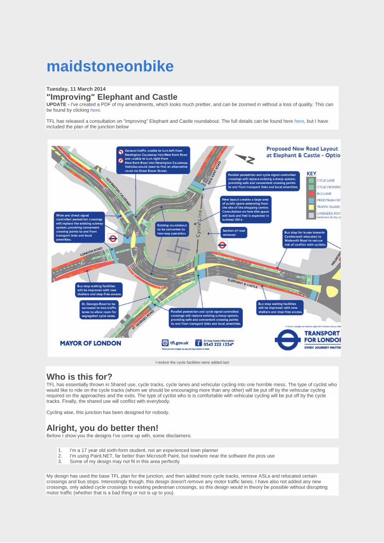
maidstoneonbike Tuesday, 11 March 2014
"Improving" Elephant and Castle UPDATE - I've created a PDF of my amendments, which looks much prettier, and can be zoomed in without a loss of quality. This can be found by clicking here. TFL has released a consultation on "improving" Elephant and Castle roundabout. The full details can be found here here, but I have included the plan of the junction below
I reckon the cycle facilities were added last
Who is this for? TFL has essentially thrown in Shared use, cycle tracks, cycle lanes and vehicular cycling into one horrible mess. The type of cyclist who would like to ride on the cycle tracks (whom we should be encouraging more than any other) will be put off by the vehicular cycling required on the approaches and the exits. The type of cyclist who is is comfortable with vehicular cycling will be put off by the cycle tracks. Finally, the shared use will conflict with everybody. Cycling wise, this junction has been designed for nobody.
Alright, you do better then! Before I show you the designs I've come up with, some disclaimers:
1. I'm a 17 year old sixth-form student, not an experienced town planner 2. I'm using Paint.NET, far better than Microsoft Paint, but nowhere near the software the pros use 3. Some of my design may not fit in this area perfectly
My design has used the base TFL plan for the junction, and then added more cycle tracks, remove ASLs and relocated certain crossings and bus stops. Interestingly though, this design doesn't remove any motor traffic lanes. I have also not added any new crossings, only added cycle crossings to existing pedestrian crossings, so this design would in theory be possible without disrupting motor traffic (whether that is a bad thing or not is up to you).
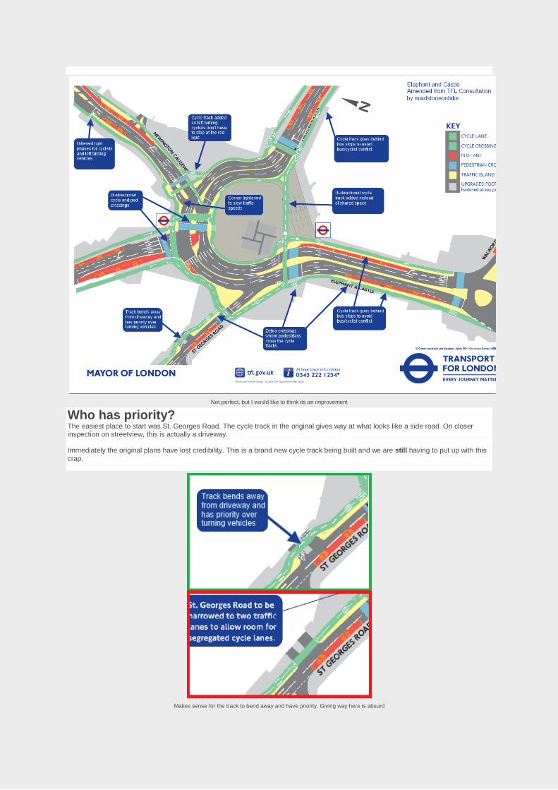
Not perfect, but I would like to think its an improvement
Who has priority? The easiest place to start was St. Georges Road. The cycle track in the original gives way at what looks like a side road. On closer inspection on streetview, this is actually a driveway. Immediately the original plans have lost credibility. This is a brand new cycle track being built and we are still having to put up with this crap.
Makes sense for the track to bend away and have priority. Giving way here is absurd
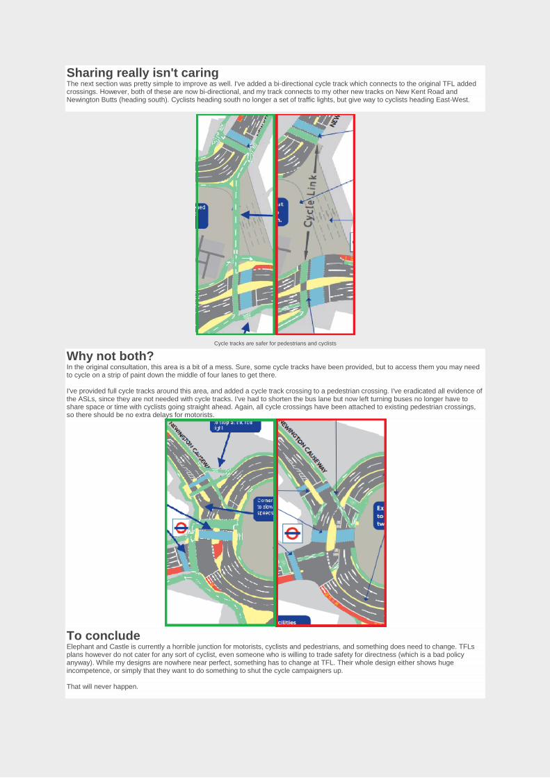
Sharing really isn't caring The next section was pretty simple to improve as well. I've added a bi-directional cycle track which connects to the original TFL added crossings. However, both of these are now bi-directional, and my track connects to my other new tracks on New Kent Road and Newington Butts (heading south). Cyclists heading south no longer a set of traffic lights, but give way to cyclists heading East-West.
Cycle tracks are safer for pedestrians and cyclists
Why not both? In the original consultation, this area is a bit of a mess. Sure, some cycle tracks have been provided, but to access them you may need to cycle on a strip of paint down the middle of four lanes to get there. I've provided full cycle tracks around this area, and added a cycle track crossing to a pedestrian crossing. I've eradicated all evidence of the ASLs, since they are not needed with cycle tracks. I've had to shorten the bus lane but now left turning buses no longer have to share space or time with cyclists going straight ahead. Again, all cycle crossings have been attached to existing pedestrian crossings, so there should be no extra delays for motorists.
To conclude Elephant and Castle is currently a horrible junction for motorists, cyclists and pedestrians, and something does need to change. TFLs plans however do not cater for any sort of cyclist, even someone who is willing to trade safety for directness (which is a bad policy anyway). While my designs are nowhere near perfect, something has to change at TFL. Their whole design either shows huge incompetence, or simply that they want to do something to shut the cycle campaigners up. That will never happen.

Appendix G
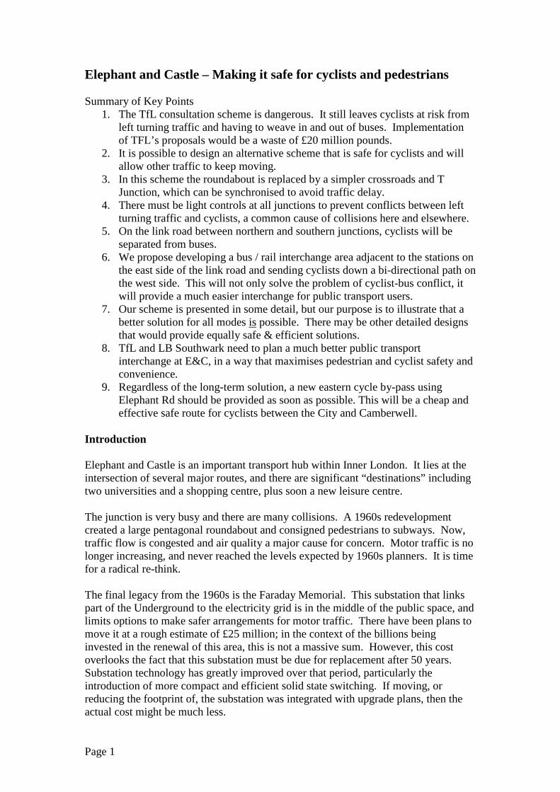
Elephant and Castle – Making it safe for cyclists and pedestrians Summary of Key Points
1. The TfL consultation scheme is dangerous. It still leaves cyclists at risk from left turning traffic and having to weave in and out of buses. Implementation of TFL’s proposals would be a waste of £20 million pounds.
2. It is possible to design an alternative scheme that is safe for cyclists and will allow other traffic to keep moving.
3. In this scheme the roundabout is replaced by a simpler crossroads and T Junction, which can be synchronised to avoid traffic delay.
4. There must be light controls at all junctions to prevent conflicts between left turning traffic and cyclists, a common cause of collisions here and elsewhere.
5. On the link road between northern and southern junctions, cyclists will be separated from buses.
6. We propose developing a bus / rail interchange area adjacent to the stations on the east side of the link road and sending cyclists down a bi-directional path on the west side. This will not only solve the problem of cyclist-bus conflict, it will provide a much easier interchange for public transport users.
7. Our scheme is presented in some detail, but our purpose is to illustrate that a better solution for all modes is possible. There may be other detailed designs that would provide equally safe & efficient solutions.
8. TfL and LB Southwark need to plan a much better public transport interchange at E&C, in a way that maximises pedestrian and cyclist safety and convenience.
9. Regardless of the long-term solution, a new eastern cycle by-pass using Elephant Rd should be provided as soon as possible. This will be a cheap and effective safe route for cyclists between the City and Camberwell.
Introduction Elephant and Castle is an important transport hub within Inner London. It lies at the intersection of several major routes, and there are significant “destinations” including two universities and a shopping centre, plus soon a new leisure centre. The junction is very busy and there are many collisions. A 1960s redevelopment created a large pentagonal roundabout and consigned pedestrians to subways. Now, traffic flow is congested and air quality a major cause for concern. Motor traffic is no longer increasing, and never reached the levels expected by 1960s planners. It is time for a radical re-think. The final legacy from the 1960s is the Faraday Memorial. This substation that links part of the Underground to the electricity grid is in the middle of the public space, and limits options to make safer arrangements for motor traffic. There have been plans to move it at a rough estimate of £25 million; in the context of the billions being invested in the renewal of this area, this is not a massive sum. However, this cost overlooks the fact that this substation must be due for replacement after 50 years. Substation technology has greatly improved over that period, particularly the introduction of more compact and efficient solid state switching. If moving, or reducing the footprint of, the substation was integrated with upgrade plans, then the actual cost might be much less.
Page 1
Promoting walking and cycling. Safety and convenience are the two factors that limit walking and cycling. Our prime focus here is on safer cycling; however, our proposal also improves walking through longer green times and shorter crossing distances. In addition, our proposal for an integrated bus/train interchange would benefit the many people who have to cross busy roads to get from bus to train or tube every day. Walking. To encourage walking we need safe AND quick routes. The present subways are safe, but slow. TfL’s proposed surface crossings are, at the two busiest sites, 2-stage, so they will still be slow. Pedestrian crossing flows would be reduced if buses on the Link road were brought to a bus interchange adjacent to the Northern Line and Network Rail stations. At present a significant percentage of people crossing are going from buses stopping on the West side and heading for the stations on the east side. Cycling 36 collisions involving cyclists, 30 slight, 6 serious, occurred at the Northern roundabout over the 2-year period 2011-12. The risks here put many people off cycling. In addition, it is notable that the commuter cyclists who do ride the northern roundabout are predominantly young adult males. There are bypass routes both to the east and west. They are slow and are used by perhaps 10% of the numbers using the main carriageway. The eastern bypass could be much improved by taking it via Elephant Road. This would provide a convenient route from Newington Causeway to Walworth Rd. It would be a cheap and effective way to reduce cycle traffic through the northern and southern junctions and should be carried out as soon as possible and independently of work on the northern junction. The proposed route is shown on Drawing 1 below. Making Elephant and Castle safe for cyclists requires similar designs to successful cycling cities in northern Europe. The key principles are: (a) protection at junctions by appropriate light control (b) protection between junctions by segregation from motor traffic and (c) keeping cyclists always next to the kerb, never in lanes in the middle of traffic. These principles are well set out in the Mayor’s Vision for Cycling. Why have these proven principles not been applied to the current TfL proposal for either the Northern or Southern junction? At all the E&C junction(s), the key issue is safety. Three principal types of collision occur at these junctions: Shunts where one vehicle runs into the rear of another. Left hooks where a left-turning motor vehicle hits a cyclist going straight on. Collision during right turns where a cyclists turning right is hit by a motor vehicle going straight on or left. There are now new ways of designing junctions and of light controlling them that eliminate left hooks and collisions during right turns. To avoid shunts on approaches, it is important to provide protected lanes or segregated tracks. Does the TfL proposal provide for safe and convenient cycling? The simple answer is NO.
Page 2
Option A is dangerous. Option B is slow (and dangerous for pedestrians). The dangers are as follows: Southbound
1. Link Rd, cyclists are forced away from the kerb to go round buses; 2. Link Rd/St Georges junction there is no protection from left turning motor
traffic; 3. At the London Rd junction no protection from left-turning buses; 4. At the Newington Causeway junction no protection from left-turning motor
traffic for cyclists going to New Kent Rd (NKR).
Northbound 1. London Road exit requires right-turning cyclists (the majority) to move away
from the kerb to a lane between motor traffic; 2. There is no clear route across the junction for cyclists exiting right from
London Road; 3. On the Link Road cyclists have to leave the kerb to go round buses, and will
have buses crossing the cycle lane. It is now possible to eliminate the left hooks by different signalling. There needs to be separate control of left turning traffic at all junctions. Additional lights are required to control traffic in two phases, one for left turn, one for straight ahead. Separate phases eliminate conflicts between cyclists and motor vehicles. At all the sub-junctions separate left turn and straight on phases are needed. At the London Road junction, southbound cyclists should stay at the left side and cross parallel to the pedestrians. This crossing should be a single phase. The problem of cyclists passing outside buses on the Link Rd cannot be fixed here by “floating” bus stops, as have been introduced in the new CS Highway to Stratford, as the very high numbers getting on and off buses makes floating bus stops impractical. Instead buses could unload/load within a bus / rail interchange on the East side of the Link Rd adjacent to the Overground & Underground/Network Rail stations. A safe 2-way kerbside cycle route on the west side of the link road could carry the cycle traffic. A better solution We believe this solution is safe and convenient for cyclists and pedestrians / passengers, and will not have a significant impact on motor traffic capacity. We present this solution in some detail. This is not because we think it is the “perfect” or “unique” way to tackle the problem. The detail is to show that a safe scheme IS POSSIBLE without major associated work such as moving the substation or building bridges or underpasses. Our proposal is for a crossroads at London Rd/NKR/Newington Causeway, plus a T-junction at St Georges Rd. At both junctions, turning and straight on traffic can be separately controlled thus eliminating left hooks. For cycle right turns from the Link Rd to NKR we propose a 2-stage cycle turn, as used in Copenhagen, and recently implemented on CS2 extension. The right turn from London Road for cyclists is eliminated as a bi-directional path on the outside of the loop is planned. In addition to the crossroads and St Georges T-junction, this proposal also includes a bus interchange on the E+C Link Rd. We propose bus lanes to the right of general traffic lanes in order to facilitate access to the interchange on the East side. Finally it
Page 3
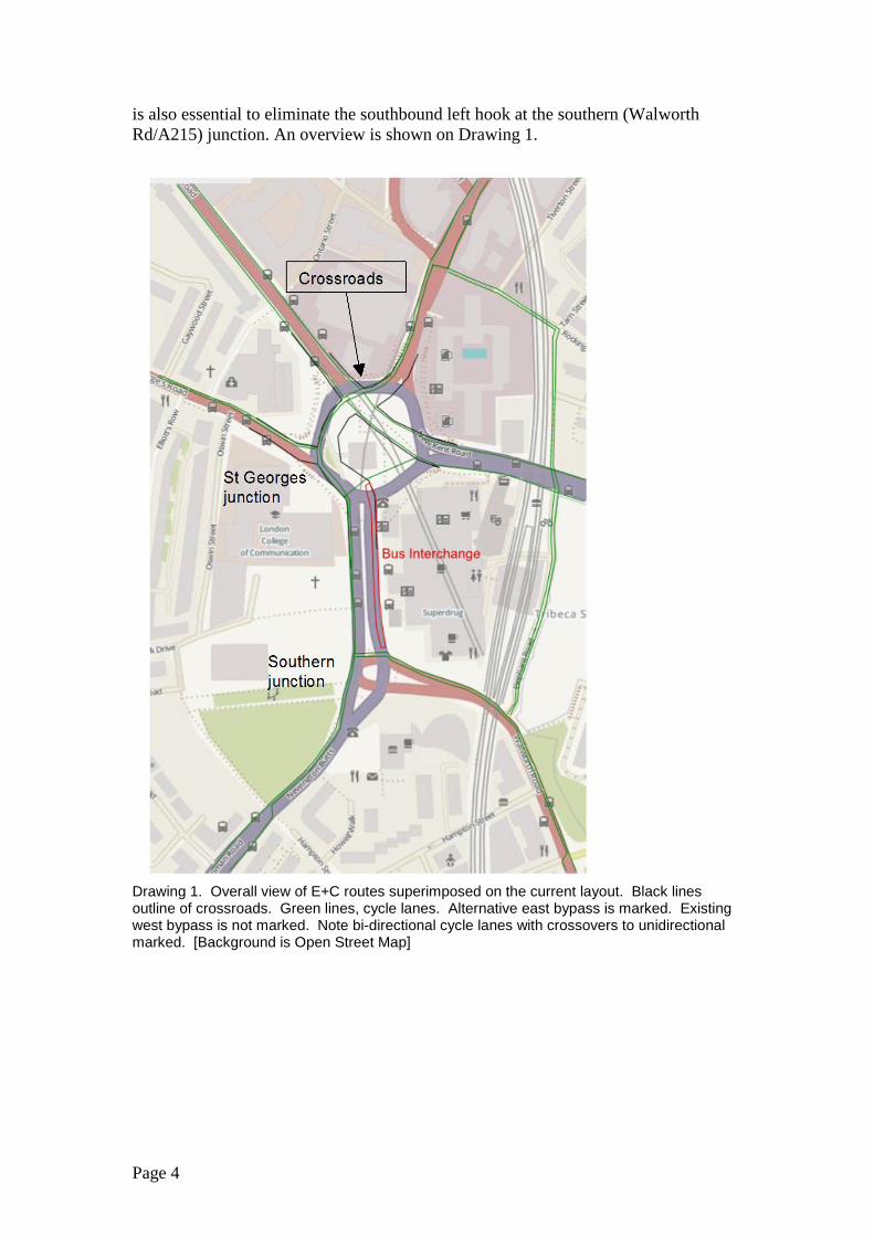
is also essential to eliminate the southbound left hook at the southern (Walworth Rd/A215) junction. An overview is shown on Drawing 1.
Drawing 1. Overall view of E+C routes superimposed on the current layout. Black lines outline of crossroads. Green lines, cycle lanes. Alternative east bypass is marked. Existing west bypass is not marked. Note bi-directional cycle lanes with crossovers to unidirectional marked. [Background is Open Street Map]
Page 4
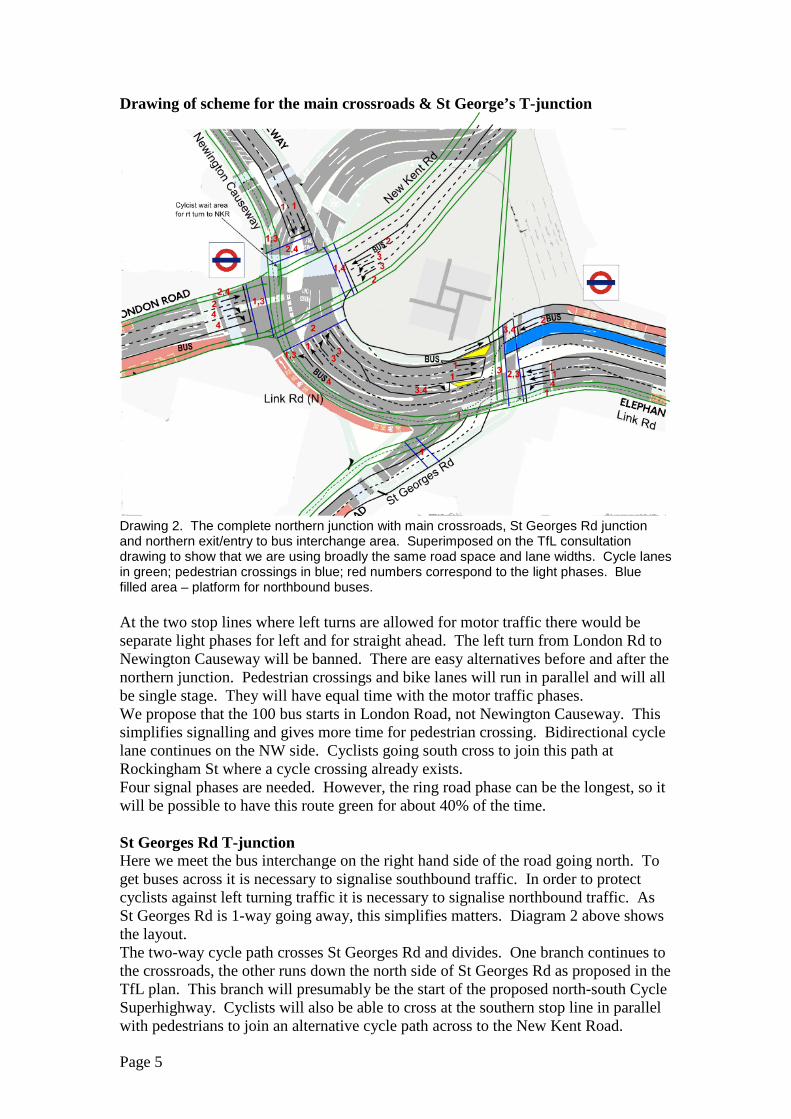
Drawing of scheme for the main crossroads & St George’s T-junction
Drawing 2. The complete northern junction with main crossroads, St Georges Rd junction and northern exit/entry to bus interchange area. Superimposed on the TfL consultation drawing to show that we are using broadly the same road space and lane widths. Cycle lanes in green; pedestrian crossings in blue; red numbers correspond to the light phases. Blue filled area – platform for northbound buses. At the two stop lines where left turns are allowed for motor traffic there would be separate light phases for left and for straight ahead. The left turn from London Rd to Newington Causeway will be banned. There are easy alternatives before and after the northern junction. Pedestrian crossings and bike lanes will run in parallel and will all be single stage. They will have equal time with the motor traffic phases. We propose that the 100 bus starts in London Road, not Newington Causeway. This simplifies signalling and gives more time for pedestrian crossing. Bidirectional cycle lane continues on the NW side. Cyclists going south cross to join this path at Rockingham St where a cycle crossing already exists. Four signal phases are needed. However, the ring road phase can be the longest, so it will be possible to have this route green for about 40% of the time. St Georges Rd T-junction Here we meet the bus interchange on the right hand side of the road going north. To get buses across it is necessary to signalise southbound traffic. In order to protect cyclists against left turning traffic it is necessary to signalise northbound traffic. As St Georges Rd is 1-way going away, this simplifies matters. Diagram 2 above shows the layout. The two-way cycle path crosses St Georges Rd and divides. One branch continues to the crossroads, the other runs down the north side of St Georges Rd as proposed in the TfL plan. This branch will presumably be the start of the proposed north-south Cycle Superhighway. Cyclists will also be able to cross at the southern stop line in parallel with pedestrians to join an alternative cycle path across to the New Kent Road.
Page 5
General motor traffic will go in 2 phases, one for traffic going straight, to and from the crossroads (40% of cycle time) and one for traffic turning into St Georges Rd (30%). In addition, two short phases (15% each) would allow (a) north and westbound buses to exit the bus interchange a cross to the left side of the road and (b) pedestrians and cyclists to cross the link road. Bus Interchange In order to separate cyclists from buses we propose that the cyclists have the west side of the Link Rd, the buses the east side, and the general motor traffic goes in the middle. This solves the problem that occurs at the moment and is still present in the TfL plan, where cyclists have to intermingle with the buses at the bus stops on the Link Rd. Remember there are 15 daytime routes using the Link Rd. There is plenty of space for an interchange here. The length of the Link Rd, from the southern junction to St Georges is about 100m, enough for nine buses. As part of the shopping centre and ticket office redevelopments it should be possible to accommodate a new fully integrated passenger interchange, with lifts. The buses, the Northern Line and the Overground/Network Rail station could have a modern integrated interchange using part of the Link Road and space vacated by the Northern Line ticket office (scheduled for redevelopment). There is an obvious opportunity here for the redeveloped shopping centre; by integrating a transport interchange into plans, one would expect an increase in shopping footfall (as e.g. Hammersmith). The southern junction This should have been included in the TfL consultation. TFL propose to continue with the unsafe southbound cycle lane sandwiched between fast traffic lanes. We propose to have separate signal phases for straight on and left turning motor vehicles. In addition, the traffic islands should be removed or greatly reduced to allow in two cases a single stage crossing. A central bus lane is needed for northbound buses to be able to access the bus interchange. The proposed layout is in Drawing 3.
Page 6
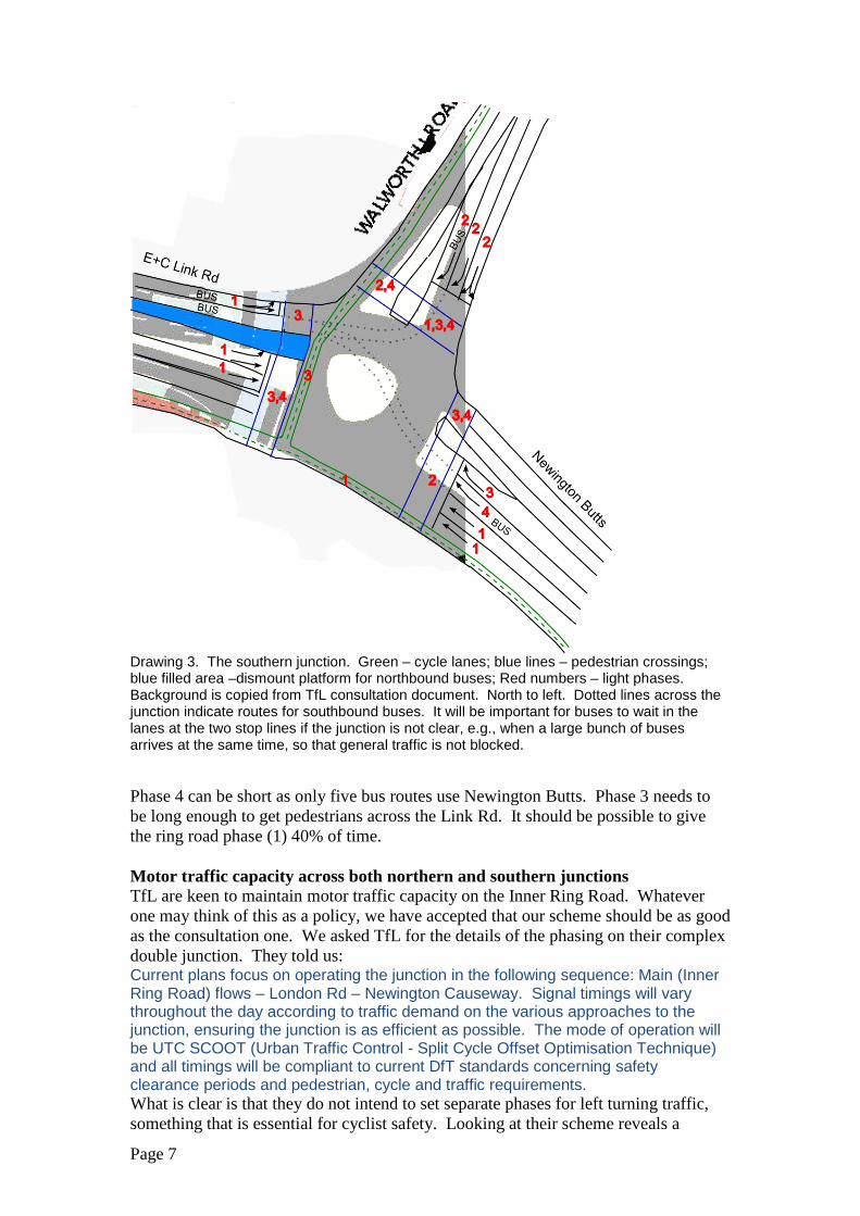
Drawing 3. The southern junction. Green – cycle lanes; blue lines – pedestrian crossings; blue filled area –dismount platform for northbound buses; Red numbers – light phases. Background is copied from TfL consultation document. North to left. Dotted lines across the junction indicate routes for southbound buses. It will be important for buses to wait in the lanes at the two stop lines if the junction is not clear, e.g., when a large bunch of buses arrives at the same time, so that general traffic is not blocked. Phase 4 can be short as only five bus routes use Newington Butts. Phase 3 needs to be long enough to get pedestrians across the Link Rd. It should be possible to give the ring road phase (1) 40% of time. Motor traffic capacity across both northern and southern junctions TfL are keen to maintain motor traffic capacity on the Inner Ring Road. Whatever one may think of this as a policy, we have accepted that our scheme should be as good as the consultation one. We asked TfL for the details of the phasing on their complex double junction. They told us: Current plans focus on operating the junction in the following sequence: Main (Inner Ring Road) flows – London Rd – Newington Causeway. Signal timings will vary throughout the day according to traffic demand on the various approaches to the junction, ensuring the junction is as efficient as possible. The mode of operation will be UTC SCOOT (Urban Traffic Control - Split Cycle Offset Optimisation Technique) and all timings will be compliant to current DfT standards concerning safety clearance periods and pedestrian, cycle and traffic requirements. What is clear is that they do not intend to set separate phases for left turning traffic, something that is essential for cyclist safety. Looking at their scheme reveals a
Page 7
problem. The stop lines at Newington Causeway and towards the New Kent Rd are a long distance from those on the peninsular road southwest of London Rd. This means substantial delays on 2 of the 3 phase transitions to allow traffic to clear. We have worked out a safe version of their scheme with the separated turns and believe they will, like us, need 4 phases. We have also simplified matters a little by banning the redundant left turn from London Rd to Newington Causeway. We think that it will be possible to have just as much “Inner ring road” time, perhaps a little more, at the crossroads than with their scheme made safe. TfL have no traffic control at the St Georges junction although there will be a light controlled pedestrian crossing. On our scheme, the through traffic can have about 40% of the cycle time. Finally, the extra phases we plan for the southern roundabout will reduce flows there slightly. Overall, we think that about 40% of green time for two lanes of inner ring road will be enough. Note that there is at present capacity to spare. Queuing is more common at Kennington Lane to the south and at the approaches to Tower Bridge to the North. Therefore, some small loss of capacity at the Elephant is unlikely to put London into gridlock. Certainly, the claim made to us by TfL Engineers that the crossroads would halve capacity at the E+C seems improbable.
Page 8
Appendix H
Submission to TfL in response to their consultation about the Elephant and Castle Roundabout Proposal April 2014 on behalf of the campaign from ElephantandCastleRoundabout.org This response represents over 300 signatories who have signed up in support of the campaign and can also take some credit for the 2,000 or so signatories for a Safer Elephant, a campaign document that we helped lead author Jeremy Leach write. It is based on 18 months of study, analysis and discussion. We welcome: - Investment in the transport infrastructure.
o What is there today is woefully neglected, particularly the subways and pavements creating an unwelcoming atmosphere to those unfamiliar with the area.
o Recognition that improvements are needed for cyclists - Narrowing St George’s Road to motorists.
o It is unnecessarily wide given, it’s scale dates from a time when the Congestion Zone didn’t exist and neither did the northbound bus lane on St George’s Road. The curerent width encourages fast driving
- Installing a two way cycle lane down the length of St George’s Road (though we do not agree extending it all the way towards the roundabout)
o This will improve access between the Elephant and Castle and Waterloo and Lambeth North and encourage cyclists to avoid London Road, leaving more room for motor traffic to safely use this busy road.
We disagree strongly with: - The objective of making the roundabout “a place to be” by creating a
peninsula piazza pedestrian space. o “A place to be” is how Ben Plowden of TfL describes his objective for
the junction in an e-mail to us. Yet the role of making the Elephant and Castle a place to be falls to developers and the council who are investing in retail, recreation, business and residential space. It also falls to the community. TfL’s responsibility is making routes for people safe, pleasant and without congestion pass through it, to it and from it – but most importantly, it must be to enable us to get around, not purposefully encourage us to linger.
o This dubious objective of a new piazza is all the more pointless in the context of the area’s redevelopment. There are 5 new parks and squares under development within 5 minutes of this junction – the all new Market Square, Walworth Square, Elephant Park and Victory Place and the redevelopment of St Mary’s Churchyard. This will help make the Elephant and Castle a place to be without any negative impact on congestion.
o TfL have an exceedingly poor track record of maintaining green surface space in this area and beyond. Southwark Council have made it clear they do not want the responsibility for this new landscape – Jon Abbott (Southwark’s Head of Regeneration) told me he felt

Delancey, the new owners of the shopping centre should pay for its upkeep – Delancey were of course appalled to here this.
o The piazza will become a blight and a cost to whoever takes responsibility for it.
o The orientation of Delancey’s new shopping centre is towards Walworth Road and the rest of the area’s retail offer, it is not towards this peninsula piazza.
o The effect of creating this piazza is to lengthen the ring road for all traffic heading west or south.
o The appeal of a piazza adjacent to a more polluted six lane ring road will be low.
o However fancy your landscape architect is does not guarantee a design that is fit for purpose or good value for money. In 2008 Southwark Council employed Martha Schwartz to redesign St Mary’s Churchyard at a cost of £1.5m. Within less than a year it was falling apart. Within 3 years I was sharing a platform with Martha at a RIBA debate (alongside TfL’s Ben Plowden too) and slammed the quality of the park. In 2014 it is being dug up and redesigned again.
o This junction is far too busy and will only get busier when the widespread redevelopment of the area is completed and 1000s of new residents move in. London’s forecast growth will also put this junction under greater pressure. This junction is the wrong place to squeeze in a piazza and intentionally increase congestion.
- Not integrating the redesign of the junction with the big opportunity
that has only become possible since November 2013 – that of the demolition and rebuild of the shopping centre and northern line.
o Integrating the design would enable the position of the northern line exit to be moved and optimized rather than left adjacent to congested urban motorway.
o It enables existing infrastructure, such as subway 8, 16 and 20 to be integrated into the shopping centre and a standard central London-style subterranean underground ticket hall, much as one finds at Piccadilly Circus.
o Delancey – the new owners of the shopping centre – have confirmed that they are in no way dependant on the specific proposal from TfL nor on the piazza. They want improvement and they want to be collaborating with that improvement.
o It would soon make making obsolescent the new piazza with subsequent adjacent comprehensive redevelopment.
o Coordinating the disruption of creating the two developments, benefiting from interim use of space.
- Accepting increases in congestion for any user, (particularly pedestrians)
o Journeys for all users, except for the two most infrequent pedestrian routes will be slower - TfL data shows. This is totally unacceptable, particularly in the context of forecast growth and congestion.
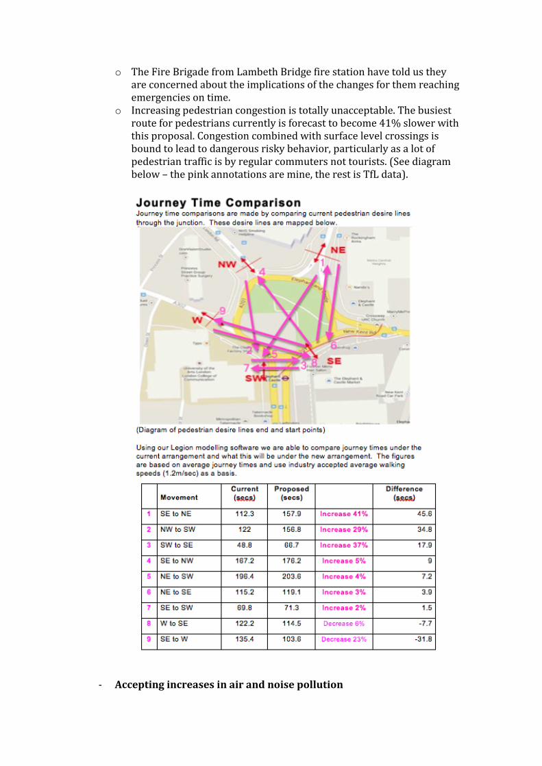
o The Fire Brigade from Lambeth Bridge fire station have told us they are concerned about the implications of the changes for them reaching emergencies on time.
o Increasing pedestrian congestion is totally unacceptable. The busiest route for pedestrians currently is forecast to become 41% slower with this proposal. Congestion combined with surface level crossings is bound to lead to dangerous risky behavior, particularly as a lot of pedestrian traffic is by regular commuters not tourists. (See diagram below – the pink annotations are mine, the rest is TfL data).
- Accepting increases in air and noise pollution
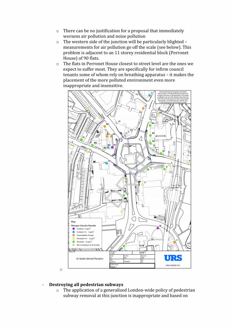
o There can be no justification for a proposal that immediately worsens air pollution and noise pollution
o The western side of the junction will be particularly blighted – measurements for air pollution go off the scale (see below). This problem is adjacent to an 11 storey residential block (Perronet House) of 90 flats.
o The flats in Perronet House closest to street level are the ones we expect to suffer most. They are specifically for infirm council tenants some of whom rely on breathing apparatus – it makes the placement of the more polluted environment even more inappropriate and insensitive.
o
- Destroying all pedestrian subways o The application of a generalized London-wide policy of pedestrian
subway removal at this junction is inappropriate and based on
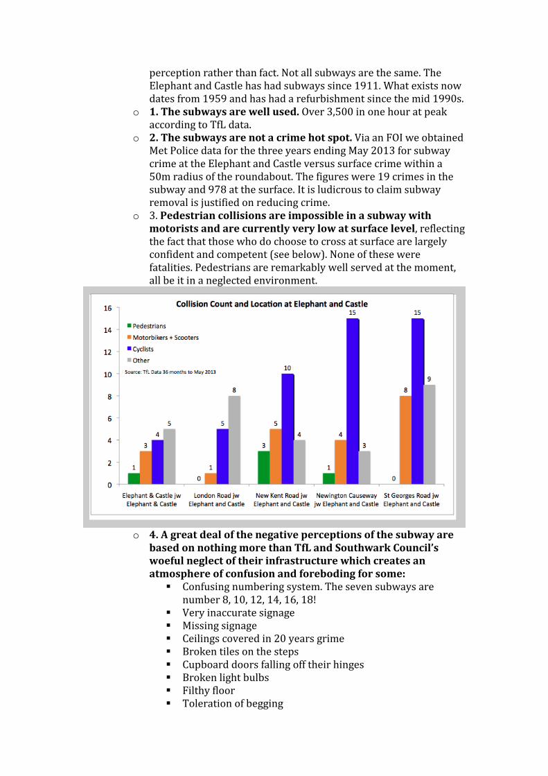
perception rather than fact. Not all subways are the same. The Elephant and Castle has had subways since 1911. What exists now dates from 1959 and has had a refurbishment since the mid 1990s.
o 1. The subways are well used. Over 3,500 in one hour at peak according to TfL data.
o 2. The subways are not a crime hot spot. Via an FOI we obtained Met Police data for the three years ending May 2013 for subway crime at the Elephant and Castle versus surface crime within a 50m radius of the roundabout. The figures were 19 crimes in the subway and 978 at the surface. It is ludicrous to claim subway removal is justified on reducing crime.
o 3. Pedestrian collisions are impossible in a subway with motorists and are currently very low at surface level, reflecting the fact that those who do choose to cross at surface are largely confident and competent (see below). None of these were fatalities. Pedestrians are remarkably well served at the moment, all be it in a neglected environment.
o 4. A great deal of the negative perceptions of the subway are
based on nothing more than TfL and Southwark Council’s woeful neglect of their infrastructure which creates an atmosphere of confusion and foreboding for some: Confusing numbering system. The seven subways are
number 8, 10, 12, 14, 16, 18! Very inaccurate signage Missing signage Ceilings covered in 20 years grime Broken tiles on the steps Cupboard doors falling off their hinges Broken light bulbs Filthy floor Toleration of begging
None of these problems are beyond fixing at the very least and radically changing perceptions, as has recently been invested in at Old Street.
o 4. Our interviews with users indicate that the subways are particularly popular with parents of young children, school-teachers, the elderly – people who are not comfortable or confident waiting by an urban motorway, on traffic islands and racing to cross the road in time.
o At the very least an alternative use should be found for them rather than wasting this precious space by just filling them in. In this way their cultural value of the historic murals and dazzling tiles could also partially be preserved.
- Creating cycle routes adjacent to the ring road and bus lanes. o It is baffling that absolutely no consideration has been given by TfL
to the role adjacent roads could play in serving the needs of many cyclists – particularly the less confident ones who do not want to cycle with traffic. The proposal is blind to anything that is not on a red route, even your existing provision of CS7 along quiet back streets of Princess St, Elliott’s Row and behind St Mary’s Churchyard.
o Southwark Council’s Head of Regeneration Jon Abbot has said he will not be using the new cycle lanes proposed, instead he will cycle with the cars. He typifies the confident cyclist who feels safer and swifter with cars rather than in cycle lanes of any kind. So why not cater to less confident cyclists more whole heartedly by helping them easily avoid this busy junction altogether. Confident cyclists could be catered for safely on the roundabout by enforcing greater lane discipline from motorists. There are no lanes on much of the junction and the carriageway is also unnecessarily wide, particularly on the northern side. Our Alternative Proposal shows how the lanes could be narrowed, making traffic a little slower without grinding it to a congesting and polluting halt.
o There is great potential in completing a cycle bypass at the Elephant and Castle, particularly in making better use of Elephant Road that will pass alongside the new Market Square and next to the railway station on what is currently just a one way single lane road. There is potential for cycle routes adjacent to the Castle Leisure Centre and also across New Kent Road adjacent to the railway viaduct.
o Even existing CS7 has been missed out of the proposal, Will Miller of TfL explained this as “because it’s existing infrastructure”… and yet the existing tube stations are shown. It’s as if this plan is blind to anything other than a red route.
- Cycling Route cutting across Pedestrian Piazza
o We have already stated the objection to the place making objectives of the piazza. We also object to it’s compromise by being cut through with a poorly defined, dangerous and pedestrian
delaying “cycle link”. The cycle link is the vestigial evidence that a roundabout makes much better sense here. If the cyclists can have a roundabout why should other traffic, so it isn’t so congested? Traffic that emits fumes would be even more suitable for using this link road.
- Widening London Road
o It has been explained to us that the knock on effect of congestion caused by the peninsula and more surface level crossings is so bad that London Road must be widened to prevent busses backing up across the junction.
o The consequence of widening London Road is that even more noise and air pollution for the 90 flats of Perronet House reaches us.
o Another consequence of widening the road is the felling of three mature trees that currently mitigate the pollution.
o The pavement here is already congested with pedestrians at rush hour serving the bus stops and trying to pass up London Road towards St George’s Circus. Widening London Road will make that congestion even worse.
- Creating a 6 lane two lane carriage way on the western side
o This is one of the negative side effects of the proposed peninsula piazza.
o It also requires the felling of a huge mature London plane tree that currently mitigates the pollution.
- Misplacing several surface level crossings
o Given TfL’s dogmatic insistence that all subways must go it’s all the more disappointing to see so many surface level crossings placed away from the natural desire lines – compromised placements forced by the peninsula, the cycle lanes, the subway demolition.
o The desire line on the link road between the Tabernacle and the tube is not fulfilled – the crossings are too far north
o The desire line across New Kent Road is not fulfilled – the crossing is too far east to satisfy the current desire line served by the subway and too far west to safisfy the desire line to cross in line with Elephant Road and the viaduct pedestrian cutting.
o The desire line from London Road to the centre of the roundabout is not fulfilled – the existing surface level crossing is removed and replaced by one on the opposite side of the road!
- Creating inadequate pedestrian crossings
o Too many of the surface level crossings are two stage crossings, which causes delay and frustration and clearly reinforce the perception that pedestrians are even more subservient to motorists here, they don’t even get their own dedicated collision free zone.
o The precedent set by the changes at the southern junction does not bode well. There the green man shines for 5 seconds versus over a minute for the red man… and that only gets you half way across the road, so people take risks.
o Surface level crossings should be quick, and where possible zebra crossings to give pedestrians priority.
- Going about the consultation like it’s a sales pitch
o The emphasis in the consultation on manipulative CGI - no LCD billboards despite their very recent installation, unrealistically large trees, cropped to exclude the 6 lane ring road and vast widening of London Road.
o The exclusion of all residents and users in earlier discussions (except members of the Strategic Stakeholder Forum that intentionally excludes the two residential blocks at the roundabout Metro Central Heights and Perronet House).
o A push-poll style survey that asks manipulative questions to change views rather than genuinely useful answers.
o The absence of evidence for decisions, or even clearly presented facts when requested and the emphasis on generalized policies rather than detailed study here.
We propose:
1. Take all your plans off the table 2. Return with a blank sheet of paper to engage people in the following
process: a. Review and publish usage data, collision data and crime data as
well as forecasts for the area without change. b. Ignore all but written submissions to the current consultation, the
survey is too manipulative to be taken seriously. c. Agree transport objectives for the junction and wider area. d. Audit all adjacent features, changes and opportunities. e. Agree key landscape and transport features to fulfill those
objectives. f. Draft options for transport configuration. g. Choose option and ideally phase it’s creation. h. Brief landscape architect where necessary. i. Celebrate completion in stages.
To help you on your way please review The Alternative Proposal 1 which shows a phased proposal enabling momentum to be sustained by lasting improvements possible without the negative side effects TfL. Download it here or review thumbnail below: http://www.elephantandcastleroundabout.org/betterjunction/AlternativeProposal1.pdf

Appendix I
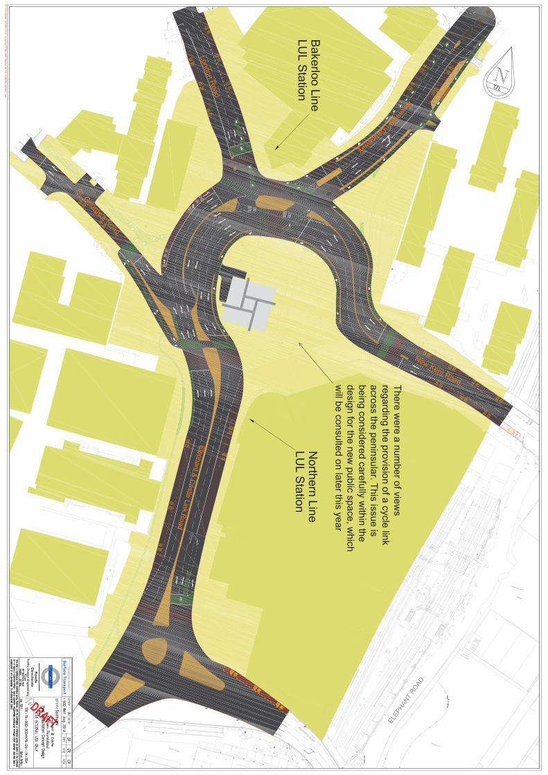

Appendix J