Embed Size (px)
Citation preview

i
ELEMENTS OF CIVIL ENGINEERING
Dr. K. Prakash Professor & Head
Department of Civil Engineering Sri Jayachamarajendra College of Engineering, Mysore – 570006.

ii
1st Edition – 2007
2nd Edition – 2013
3rd Edition – 2015
iii
FOREWORD
The role of Civil Engineering in the societal development through
infrastructural development projects is gaining more importance in the recent
days. All engineering students irrespective of their branch are expected to have
some information about the field of Civil Engineering. This volume intends to
give some basic information about the field of Civil Engineering, Infrastructural
Development Projects and Typical Infrastructural Facilities. It is hoped that this
volume satisfies the requirement of the students admitted afresh to the
engineering education.
K. Prakash

iv

v
CONTENTS
Page No.
Foreword iii
Contents v
1. Civil engineering and infrastructure development 1
2. Roads 11
3. Bridges 26
4. Dams 36

K. Prakash
1
Chapter – 1
CIVIL ENGINEERING AND INFRASTRUCTURE DEVELOPMENT
INTRODUCTION
Engineering is the profession that puts scientific knowledge to practical use. i.e.,
Engineering is an applied science. Engineers look for better and optimized ways to use
existing resources and often develop new resources & new materials.
In general, the filed of engineering includes a wide variety of activities. Engineering
projects range from the construction of huge dams to the design of tiny electronic circuits.
Engineers may help to produce guided missiles, industrial robots, or artificial limbs for the
physically handicapped. They develop complex scientific equipments to explore the reaches
of outer space and the depths of the oceans. Engineers also plan electric power and water
supply systems, and deal with automobiles, television sets, and other consumer products.
They work to reduce environmental pollution, increase the world’s food supply, and make
transportation faster & safer.
Out of all branches of engineering, Civil Engineering is the one that is directly
associated with the welfare of the society. ‘Civil Engineering’, a branch full of human
activities, has been pursued from very early times when man began to adopt the environment
to his needs. The motto of the civil engineering is the “protection of the welfare and safety of
the public”. Indeed, the term civil in civil engineering refers to the discipline’s involvement
in public works, including government buildings, military bases, mass transit systems (i.e.,
highways, railways, airports, and water ways), water treatment works, waste management,
irrigation etc. In ancient times, there was no formal engineering education. The earliest
engineers built structures and developed tools by experience and by methods which were
empirical in nature. However, the present day engineering activities are based on sound
theoretical knowledge. Guided by theory and the past experience, the present day civil
engineers work for the benefit of the society, carrying out the works according to certain
standards. Maintaining the quality in their works help them to achieve good performance
from their outputs.

K. Prakash
2
SCOPE OF CIVIL ENGINEERING
The scope of Civil Engineering is very vast, and it has many diversified fields which
help in the total development of any civilisation. Various subdivisions that come under civil
engineering branch are listed below.
Surveying
Building Materials Technology
Geotechnical Engineering
Structural Engineering
Construction Technology
Hydraulics
Water Resources and Irrigation Engineering
Transportation Engineering
Environmental Engineering
A brief description of the contents of study of each of these sub-divisions is given
below
Surveying
It is a field of specialisation which involves processes through which the relative
positions of various points are objects on the earth’s surface are determined on a horizontal
plane as well as on a vertical plane. The results of such processes are represented in the form
of map or plan. A plan is a graphical representation of various ground features as projected
on a horizontal plane, to some convenient scale, on a sheet of paper.
Surveying is an essential work which is carried out in the beginning of any
constructional activity, such as development of an area, construction of transportation
facilities such as road ways, railways and air field pavements, construction of structures such
as buildings, bridges, dams and the like.
Conventional methods of surveying include chain surveying, compass surveying,
theodolite surveying, plane table surveying and levelling. The modern day surveying, by
virtue of developments in technology, include the use of sophisticated instruments like total
station and other electronic, electro-magnetic, electro-optical instruments and tools such as

K. Prakash
3
Geographic Information System (GIS), Global Positioning System (GPS) and the like. It also
makes use of allied fields such as remote sensing and photogrammetry.
Building Materials Technology
Any constructional activity invariably requires the use of different types of materials.
These materials of construction can be broadly classified in to
Conventional materials (Ex: soil, stones, bricks, timber, cement / lime, tiles, plain
and reinforced cement concrete, pre-stressed concrete).
Modern building materials (Ex: Fibre reinforced concrete, aluminium, glazed tiles,
plaster of Paris).
Alternate building materials (Ex: Fly ash, polymeric materials, industrial wastes,
recycled aggregates).
Smart materials.
Depending upon the requirement, budget and other constraints, any combination of
these materials can be used in the construction works. Building materials technology deals
with a detailed study of these materials of construction – origin / fabrication / manufacture,
types, properties, functional advantages, limitations. These information help in judging the
suitability of different materials to be used in the proposed constructional activity.
Geotechnical Engineering
All structures built on earth transfer the superimposed loads to the ground (soil / rock)
underneath, through appropriate foundation. Soils are complex geological materials which
are expected to receive the loads transferred to them safely without causing damage to the
structure. The soils are physico-chemically active materials, and their engineering behaviour
depends upon their water content. This subject encompasses
a detailed study of soils – formation, composition, properties and their
determination
a detailed study of rocks – types, properties, strength and deformation
characteristics and their determination.
different types foundations, their relative merits and limitations, suitability and
design aspects.
design and analysis of various earth structures such as embankments, dams,
retaining walls etc.

K. Prakash
4
site investigation, sub-soil exploration and field tests.
Ground improvement techniques
Geotechnical earthquake engineering is a specialised field of geotechnical
engineering, which deals with earthquakes, their effects on foundation soil, different types of
seismic hazards, study of dynamic soil properties, seismic design of earth structures, soil
improvement to withstand / minimise seismic hazards etc.
Structural Engineering
All structures constructed on this earth are subjected to various types of loads of
different complexities / nature. Various components of a structure are expected to respond to
these loads favourably and to withstand them safely. The satisfactory performance of
structures requires the knowledge of materials’ behaviour and selection of appropriate
material for use, proportioning / designing different components of a structure, estimating the
stresses developed in different component of a structure and back checking the design. This
field includes subjects like engineering mechanics, strength of materials, structural analysis
and design of structures. It also requires the knowledge of different tools to carry out the
analysis and design of structural components such as matrix method of analysis, finite
different techniques, finite element method of analysis and the like.
Construction Technology
All activities undertaken in the construction of any structure come under this field.
Construction of various types of structures, making use of various types of constructional
materials available, study of different technologies of construction, management of various
constructional activities with respect to different parameters like resources (material /
human), time, finance and legal aspects are included in this field of civil engineering.
Hydraulics
Water is an integral part of human life and of almost all constructional activities. This
subject deals with
basic properties of water
study of water at rest as well as in motion
flow through pipes
open channel flows

K. Prakash
5
flow measurements
different analytical, computational and experimental approaches to analyse the
flow problems.
Water Resources and Irrigation Engineering
There are different sources of fresh water on this earth such as rain, ground water,
streams / rivers. These waters have to be harnessed and stored properly before they are
utilised for different purposes such as drinking, irrigation and water power generation. This
subject deals with
different sources of water on this earth
estimation of total water available and water requirement
construction and maintenance of structures to tap the available resources of water
planning and building of water retaining structures such as tanks / dams
construction and maintenance of water carrying structures
different irrigation schemes
flood control methodologies
depletion and replenishment of water resources
Transportation Engineering
The social and economical development of any country is a function of transportation
facilities available in that country. Different means of transportation include roadways,
railways, air ways and water ways. This field deals with a detailed study of planning, design,
construction and maintenance of different types of road ways, railways, airports and runways,
harbours and docks, bridges and tunnels.
Environmental Engineering
This subject deals with
study of available water quality and checking against the standards
water collection and water purification through various treatment processes
supply and distribution of quality water for urban and rural areas, for domestic and
industrial usage
study of domestic water supply system and sanitary system
waste water collection, treatment and safe disposal
study of wastes and waste management

K. Prakash
6
study of different kinds of pollution and pollution control measures
study of environmental safety
INFRASTRUCTURE
Infrastructure is a system of services and communication that is required for the over all
development of the society. It refers to facilities such as transportation (i.e. Railways,
Highways, Air ways, Water ways etc.,), hospitals, education, energy (coal, electricity, oil
etc.), irrigation, farm equipments & machineries, science and technology, communication,
health & hygiene, banking that facilitate and contribute in the process of production of goods
and services for the overall development of the economy of the society.
The infrastructure is of two types.
a) Economic infrastructure: It contributes directly to the economic development of any
country. It consists of transport and communication, power supply, irrigation
networks, financial institutions etc.
b) Social infrastructure: It contributes to the process of economic development of any
country indirectly. It consists of education & training, health & family welfare,
housing & water supply and other civic amenities.
Transport and Communication:
In this modern age, transport along with electricity and power forms the basic
infrastructural requirement for industrialization. Transport provides vital link between
production centres and distribution points. It also exercises a unifying and integrating
influence upon the economy. Indeed, transport facilitates agricultural development by
supply of modern inputs like seeds, chemical fertilizers, pesticides, farm implements and
machinery. Transport helps the movement of agricultural produce from scattered farms to the
distant markets. It helps the industrial development by facilitating the regular and prompt
movement of raw materials and labour to the factories and finished products to market. It
helps to widen the market for wide variety of industrial goods. Transport helps to widen the
market and trade. It facilitates exploitation of natural resources, helps the mobility of labour,
and serves administration and defence requirements.

K. Prakash
7
The important means of transport are railways, roadways, waterways and airways.
The importance of transport services in economy depends on several economic factors such
as interdependence, mutual co-operation and co-existence of different regions. Therefore, to
integrate diversified economic regions within the country and economies of the world, a well
developed network of transport system is of vital importance.
Railways provide an economical mode of transport for freight over long distances.
The roadways are most ideal transport for short distance travel and light freight and to cater
to diverse points of production, distribution and consumption. Well-constructed roads have
become main components of economic infrastructure today. The other main components of
transport network in the economy along with roads and railways are coastal shipping, inland
waterways and domestic airlines.
Communication means imparting or transmission of information. The difference
between transport and communication is that while the former implies the conveyance of
goods and passengers from one place to another, the latter implies the conveyance of
information. The conveyance of information is necessary for the development of industry,
commerce and trade of any country. Today, a very large network of communication media
exists. These include postal services, telegraph and the telephone, radio and television
(Doordarshan), tele printers, telex, fax services, the cinema and the press. The responsibility
of building and extending the services is fixed to specialized departments and agencies like
postal department, telegraph department etc.
The communication network is also claimed to be formed under social infrastructure
of the economy. Communication can also be seen as a service in imparting education.
Education:
Education plays a vital role in the process of production; because, it imparts
knowledge, skills and capabilities to people. Investing precious resources on education and
training leads to definite economic returns, just like investing on any productive activity.
Better training and reliable research will produce better human capital.
Over and above the basic skills imparted by primary education, the growing economy
needs the secondary and much higher skills for its human resources. These can be imparted

K. Prakash
8
only to those who can pick them up in their respective fields. Thus, not everybody can be
trained to be a good mechanic or a good foreman. Such specialized skills can be met only by
high-level educational institutions like Training Institutes, Colleges and Universities from the
point of view of developing the economic resources. More than the expansion of higher
education at a greater expenditure, strengthening training and research are greatly needed.
Otherwise, the educated unemployment will increase, and it becomes a serous problem.
Housing:
This involves providing a good neighbourhood with civic amenities of living such as
water supply, sewerage, roads, electricity, schools, parks besides safety and comforts to lead
a peaceful life. Housing can either reduce or enhance the disparities in society. Social status
of any individual directly depends upon housing he / she owns.
Health & family welfare:
The provision of health services in a country reflects nation’s social priorities. The
policy programmes adopted by any country for health services have economic implications.
The emphasis should be placed on general public health measures, better sanitation and
drinking water rather than making provisions to have expensive treatment facilities to cater
only a few. The family welfare programmes also contribute a lot to the over all economy of
the country.
ROLE OF CIVIL ENGINEERS IN INFRASTRUCTURAL DEVELOPMENT
The role of Civil Engineers lies in planning the work meticulously and carrying out
the designed works systematically to achieve the most optimal and efficient output that help
the common people to lead a satisfactory life. They are also responsible for the regular
maintenance of the works carried out by them. Following illustrations explain the
complexities involved in the works to be carried out by a civil engineer.
Civil Engineering constructions vary from very simple routine works to very
complicated, huge structures. Everything depends upon the prevailing site conditions which
may or may not be favourable for the construction. Environmental conditions, location of the
site, site & soil conditions and the like may contribute to all kinds of problems, in addition to
unforeseen circumstances which may suddenly creep in. A civil engineer has to think calmly

K. Prakash
9
and take judicious and practicable decisions, considering all alternates and their pros and
cons.
Civil engineering is much more than erecting skyscrapers or bridges. The civil
engineers must have a thorough understanding of the interaction among the various units of
construction, among the various structural elements, between the structure and the complex
environment. Since constructing a large building or public-works project can involve
elaborate planning, civil engineers can be outstanding project managers. They sometimes
manage thousands of workers. They also develop advanced computerization and planning
policies.
In addition, many civil engineers are also involved with preserving, protecting, or
restoring the environment. A growing number of civil engineers are involved in many
sensitive and hazardous projects involving huge money such as cleaning up toxic industrial
or municipal wastes at abandoned dump sites, reclamation of unsuitable sites for
construction, rehabilitation of old / heritage structures, maintaining national forest parks, and
restoring the land around mines, oil wells, or factories.
In total, a civil engineer has to perform the role of a planner, a builder, an architect, a
management expert, and also an arbitrator.
IMPACT OF INFRASTRUCTURAL DEVELOPMENT
The overall development of any country is directly dependent on the infrastructural
facilities made available to the people of the country. The positive impact of developing
good infrastructural facilities can be summarised as indicated below.
Self sufficiency in food sector can be achieved
Foreign exchange can be saved
Export of surplus food products industrial products is possible.
Unemployment can be reduced through increased job opportunities
Prevention of unhealthy urbanisation can be prevented, which in turn solves many
problems such as urban congestion, acute housing shortage, traffic problems, crimes,
pollution etc.
Per capita income is increased.
The living standards of people can be enhanced.
Public health can be improved

K. Prakash
10
Inflation can be reduced.
Draught and flood related problems can be controlled / minimised
Pollution can be controlled
Literacy level of people can be increased
Public awareness gets improved
On the other hand, ill planned, ill executed and ill maintained infrastructure
development projects have negative impact on the society. Some of them are listed below.
Small scale industries, handicrafts industries and rural industries are adversely affected.
Fuel consumption is increased, which has direct impact on foreign exchange.
Environmental pollution (air, water and ground pollution) continues to increase.
The culture of the society can be adversely get affected.
Literacy level of people will come down.
Health related problems can be on the rise.
Labour problems will increase.
Inflation will increase.
If the infrastructure developments are urban centered, then that will lead to
uncontrolled urbanisation. This will aggravate the urban housing problems, water supply and
sanitation problems and urban traffic congestion. This may also result in an increase in the
crime rate.
If the infrastructural facilities provided are rich people oriented, then the gap between
the rich and poor will continue to widen. This results in an unhealthy society, full of crimes
and unrest.
*~*~*~*

K. Prakash
11
Chapter – 2
ROADS
The economic, industrial, social and cultural development of any country is directly
linked with the transportation facilities existing in that country. Following are the four major
modes of transportation.
* Roadways * Railways * Waterways * Airways
Each of these modes have their own merits and limitations. However, the transportation
through roadways is the only mode which gives maximum service to the users, because of the
flexibility and freedom it offers to the users.
Some Definitions
Terrain: It is the landscape. As per IRC, it can be classified as in Table 1.
Table – 1: Classification of Terrain
% cross slope of the ground Classification
0 – 10 Plain / Level
10 – 25 Rolling
25 – 60 Mountainous
> 60 Steep
Formation: It is the ground surface obtained for the construction of road after the earth works
are over.
Road: It is a solid and convenient path over which vehicular traffic takes place lawfully.
Pavement: It is the surface structure over the soil sub-grade constructed in order to provide
smooth and comfortable ride for the vehicles.

K. Prakash
12
HIGHWAY CROSS SECTIONAL ELEMENTS
1. Carriage way (Pavement) (Fig. 1): It is that part of a road which carries vehicular traffic.
Its width depends upon the width of the vehicle, minimum side clearance to be provided
for safety and number of lanes. (* The carriage way intended for one line of traffic
movement is called a traffic lane). It should be sufficient enough to carry the design
traffic. Hence, there can be a single lane or more lanes of traffic. The widths of carriage
way for roads with different lanes are given in Table 2.
Table 2: Widths of carriage way (as per IRC)
No. of lanes Width of carriage way
Single lane 3.75 m
Two lanes without raised kerbs 7 m
Two lanes with raised kerbs 7.5 m
Multi – lane pavements 3.5 m per lane
Note:
i. On unimportant roads, an intermediate carriage way of width 5.5 m may also be
adopted instead of a regular two lane width.
ii. On village roads, the lower limit of the width of carriage way of a single lane is 3 m.
2. Shoulder (Fig. 1): It is a strip of land provided on either side of the carriage way, which
has sufficient strength to support a loaded truck in wet weather. It serves
as an emergency lane for parking break-down vehicles
as a service lane
sometimes, for over taking
It is desirable to have a minimum shoulder width of 4 – 6 m. As per IRC, the
minimum shoulder width is 2.5 m.
3. Road way width (Width of formation) (Fig. 1): It is the total width of carriage way
together with shoulder on either side. It is nothing but the finished top width of the earth
work in cutting or in embankment. For divided highways, it includes the central medians
also. The standardised widths of roadway are listed in Table 3.

K. Prakash
13
Table 3: Width of road way for different classes of roads (as per IRC)
Class of road
Road way width: m
On plain and rolling
terrain
On mountainous and deep
terrain
National and State Highways
a. Single lane
b. Two lane
12
12
6.25
8.8
Major district roads
a. Single lane
b. Two lanes
9
9
4.75
–
Other district roads
a. Single lane
b. Two lane
7.5
9
4.75
–
Village Roads
Single lane
7.5
4
4. Right of way (Road land width) (Fig. 1): It is the land acquired for the road along its
alignment. While deciding it, cost of the land and future plans of upgrading the proposed
road should also be kept in mind. Table 4 lists the right of way for different classes of
roads.
Table 4: Recommended right of way for different classes of roads in m
Class of
road
Plain and Rolling Terrain Mountainous and steep
terrain
Open area Built-up area Open area Built-up
area
Normal Range Normal Range Normal Normal
NH & SH 45 30-60 30 30-60 24 20
MDR 25 25-30 20 15-25 18 15
ODR 15 15-25 15 15-20 15 12
VR 12 12-18 10 10-15 9 9
K. Prakash
14
5. Traffic separator (Fig. 2): It is a strip of land that may be provided on the road, which
helps to prevent head-on collisions between the vehicles moving in opposite directions on
adjacent lanes (in which case it is called as median or dividing island), to channalise the
traffic at intersections, to segregate slow traffic and to protect pedestrians. These are
normally 3 – 5 m wide.
6. Parking lanes (Fig. 2): Normally, these are provided on urban roads for parking vehicles.
A width of about 3 m is normally required for these lanes.
7. Cycle tracks (Fig. 2): These are provided in urban areas where the volume of cycle traffic
on the road is very high. Minimum width suggested for these tracks is about 2m.
8. Foot paths (Side walks) (Fig. 2): These are the path ways provided on either side of the
road exclusively for the movement of pedestrians. These are provided to protect the
pedestrians from accidents. Minimum width of foot path should be about 1.5 m.
9. Kerb: It is the boundary between the pavement and shoulder / footpath / parking space.
It may be of hard stone or of good quality precast concrete. In urban regions, it is
describe to provide kerbs.
COMPONENT OF A PAVEMENT / ROAD
Based on their structural behaviour, pavements can be of two types namely, flexible
pavements and rigid pavements.
Flexible pavement: It has four components (i) Soil sub-grade (ii) Sub-base course (iii) Base
course (iv) Surface course (Fig. 3)
Sub grade: It is the natural soil on which the roads are constructed. It can also refer to the top
of the embankment over which the pavement is laid. The surface of the sub-grade is
generally known as formation. Entire load of the structure and that of traffic on the road
surface are ultimately transferred to the sub-grade. If natural sub-grade is not of good
quality, it requires strengthening through compaction.
Sub-base course: The layer which is immediately above the sub-grade is the sub-base. It
consists of granular materials (naturally occurring / compacted / stabilized with cement or
lime). This layer shall be stronger than sub-grade. It performs the following functions.
It distributes the traffic loads to sub-grade underneath

K. Prakash
15
It acts as a good drainage layer
It prevents moisture migration from the sub-grade upwards
Natural sand, murrum, gravel, crushed stone, crushed concrete, laterite etc. can be the
granular material constituents of sub-base course.
Note: The provision of sub-base course is optional and situation dependent. If the traffic
loads are heavy and the sub-grade quality is low, the design thickness is more. In such cases,
it becomes inevitable to provide the sub-base course.
Base course: This is the main load bearing layer, underlying the wearing or surface course.
The material of the base shall be of high quality. It is normally made of crushed / broken
aggregates mechanically interlocked by rolling and bonded together with screenings, soil
binder and water (Water Bound Macadam). The main function of this layer is to withstand
the high traffic loads imposed at the surface and to distribute them to the underlying layers of
the pavement.
Surface course (Wearing course): It generally consists of a binder course (normally
bituminous macadam) and a 2 – 5 cm thick bituminous surface dressing. The functions of
this surface are
to withstand the stresses induced by the traffic, without undergoing unacceptable
deformations.
to prevent the ingress of water (i.e. water proofing the base course)
to provide a smooth, skid resistant riding surface.
Rigid Pavement: It has 2 – 3 components – Natural sub-grade, base course (optional) and
cement concrete slab (Fig. 4). The cement concrete slab itself can serve as a wearing surface
as well as an effective base course.
Some Definitions
Carpet: It is nothing but the top surface of a pavement consisting of coarse aggregates of 12.5
and 10 mm sizes, pre-mixed with bitumen or tar binder compacted to a thickness of 20 mm.

K. Prakash
16
For good performance, this course has to be covered by a suitable seat coat such as premixed
sand – bitumen seat coat before opening to traffic.
Camber (Cross Slope) (Fig. 5): It is the slope provided to the road surface in the transverse
direction to drain off the rain water from the road surface.
Super elevation (Fig. 6): Whenever a vehicle negotiates a horizontal curve on the road, by
virtue of its speed, it is subjected to a centrifugal force which tends to throw the vehicle away
from the centre of curvature of the curve. To counteract this effect, the outer edge of the road
/ pavement is raised with respect to the inner edge throughout the length of the horizontal
curve. This transverse slope given to the pavement surface is known as super elevation or
cant or banking.
Berm (Fig. 7): It is the horizontal stretch of land left at the ground level between the toe of an
embankment and the top edge of cutting, provided to ensure the stability of a long slope.
CLASSIFICATION OF ROADS
Roads can be classified based on different criteria.
I. Based on administrative jurisdiction and function:
Primary System
Express way
National Highway (NH)
Secondary System
State Highway (SH)
Major District Roads (MDR)
Tertiary System
Other District Roads (ODR)
Village Roads (VR)
Note: Highways are nothing but roadways having certain minimum standards
K. Prakash
17
Express way
These are special category of highways with superior facilities and design standards,
meant for very high volume of traffic at high speed. They are provided with divided carriage
ways, controlled access, grade separations at intersections and fencing. Parking, loading and
unloading of goods and pedestrian traffic are not permitted on these highways. They come
under the jurisdiction of central or state government depending upon whether the route is a
national highway or a state highway.
National Highway (NH)
These are the arterial roads of the country for inter-state and strategic traffic. They
connect national and state capitals, major ports, railway junctions and border. All national
highways are designated through numbers.
Ex: NH3: National Highway connecting Atari to Manali
NH21: National Highway connecting Jaipur to Agra
NH44: National Highway connecting Srinagar to Kanyakumari
Fig. 8 shows the cross section of a NH in rural area.
State Highway (SH)
These are the arterial roads of a state for inter-district traffic. They link the national
highways and highways of adjacent states, state capital with district headquarters, important
cities within the state. Sometimes, these may carry heavier traffic volume. The national and
state highways have same design speed and geometric design specifications. Fig. 8 shows the
cross section of a SH in rural area.
Major District Roads (MDR)
These are the rods within a district, for intra-district movements. They connect places
of production and market within the district and connect highways in a district. These have
lower speed and geometric design specifications than the national and state highways. Fig. 9
shows the cross section of a Major District Road.

K. Prakash
18
Other District Roads (ODR)
These serve to connect rural areas of production with the market centres, taluk head
quarters and other main roads. They have lower design specifications than MDR. Fig. 10
shows the cross section of an ODR.
Village Roads (VR)
They connect villages with each other and with the nearest district roads, state and
national highways. Fig. 10 shows the cross section of a VR.
II. Based on their suitability for usage during different seasons of the year:
All weather roads
Fair weather roads
All weather roads
These roads are negotiable during all weather except at major river crossings.
Fair weather roads
The traffic on these roads may be suspended during monsoon season due to flooding
of the roads.
III. Based on the type of road pavement:
Paved roads
Unpaved Roads
Paved roads
These roads are provided with hard pavement course.
Unpaved Roads
These roads are not provided with hard pavement course. The earth roads and gravel
roads belong to this category.

K. Prakash
19
IV. Based on the type of pavement surfacing
Surface roads
Unsurfaced roads
Surface roads
These roads are provided with bituminous or cement concrete surface.
Unsurfaced roads
These roads are not provided with bituminous or cement concrete surface.
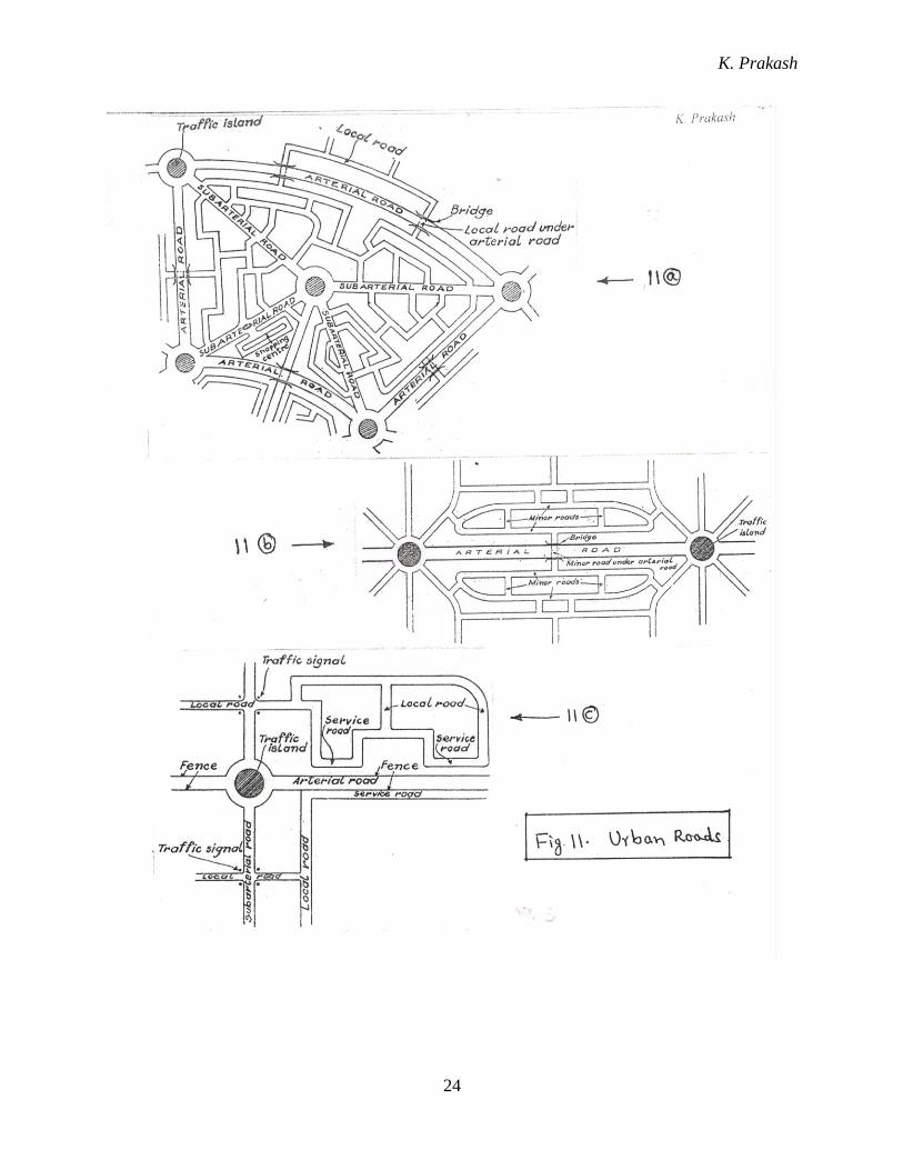
CLASSIFICATION OF URBAN ROADS
Roads in the urban areas form a separate class altogether and are classified into
Arterial roads
Sub-arterial roads or major roads
Collector streets or minor roads
Local streets
Arterial roads (Fig. 11)
These roads pass within the city limits and link the state and national highway system
with a limited access. They include ring road, by-pass road etc. These roads connect major
suburban centres and central business areas with residential areas. Parking, loading and
unloading activities on these roads are regulated. Pedestrian crossings are allowed only at
intersections. No residential buildings are allowed along these roads.
Sub-arterial roads (Fig. 11)
These roads are similar to arterial roads except that they have a lower level of traffic
mobility.
Collector streets (Fig. 11)
These roads link the residential areas, business and industrial areas with the arterial /
sub-arterial roads. Parking restrictions on these streets will not be there except during peak
hours of traffic.

K. Prakash
20
Local streets (Fig. 11)
These are the roads that connect residences, shops and industries among themselves
and with each other. There are not restrictions of parking or pedestrian movements on them.
SOME USEFUL INFORMATIONS
1. Bus bays (Fig. 12): These are the parking spaces for buses or other vehicles at stops,
provided to avoid hindrance to the moving traffic. These should be situated at least 75 m
away from road intersections.
2. By-pass: This is a stretch of road on which through traffic is high, which is provided in
such a way as to avoid entering a township or a place of traffic congestion that hinders the
traffic. This is required for an uninterrupted traffic movement.
3. Ring Road (Fig. 13): This is a circumferential road provided around a city or its inner
part, which can be used as a by-pass. The purpose of this is to avoid hindrance to through
traffic on highways from the high intra-city traffic and to provide smooth flow of traffic.
4. Radial Roads (Fig. 13): These are the roads that connect the central busy area with the
ring road or with the outskirts of an urban area.
5. Drive ways: These are the paths that connect the highways with the commercial
establishment like fuel statistics, services stations etc.
6. Service Road (Frontage road): This is a minor road parallel to the main road, providing
access to local facilities such as shops, without obstructing the main road traffic. It is
connected with the main road at selected point only. Access to the service road should be
provided at intervals of not less than 400 m.
7. Sub-way: It is an underground passage for pedestrians or to accommodate pipe lines /
cables / sewers etc.
8. Flyover: It is a structure where the traffic at different levels move separately without
provision for in interchange between them. It is a road way carried over the top of
another road way at an intersection.
9. Loop road (Fig. 14): It is a one-way turning roadway that curves about 270o to the left to
accommodate a right turning movement.

K. Prakash
21

K. Prakash
22

K. Prakash
23
K. Prakash
24

K. Prakash
25
*~*~*~*

K. Prakash
26
Chapter – 3
BRIDGES
Introduction
A bridge is a structure that provides passages for a road, railway, pedestrians, canal or a
pipeline over an obstacle without closing the way beneath. The obstacle to be covered may be a
river or a road or a railway or a valley.
Classification of bridges
Classification – I: According to function:
Foot bridge (Pedestrian bridge)
Road bridge
Railway bridge
Pipeline bridge
Viaduct
Aquaduct
Note:
1. Aquaduct is a bridge carrying a canal constructed over a drainage / passage underneath.
2. Viaduct: It is a bridge constructed over a valley.
Classification – II: According to the materials of construction:
Timber bridge
Masonry bridge
Iron bridge
Steel bridge
RCC bridge
Pre-stressed concrete bridge
Composite bridge
Classification – III: According to type of super structure:
Slab bridge (Fig. 1): Slabs (i.e. flat structural element) are placed across an open to carry the
super-imposed loads by bending action. These are used up to spans of 10 m.
Beam bridge: In this bridge, two or more rectangular beams or T-beams or I-beams are
placed parallel to one another over the piers. T-beam bridges are used for the spans 10-25 m.
Note: Normally a combination of beam and slab is adopted for bridges (i.e. beam and slab
bridge) (Fig. 2).

K. Prakash
27
Truss bridge (Fig. 3): This consists of trusses which are nothing but frame works built up of
straight members which carry the loads either by axial tension or axial compression. This
bridge can be used economically in the span range 100 – 200 m.
Arch bridge (Fig. 4): The arch bridge is best suited to deep gorges with steep rocky banks
which furnished efficient natural abutments to receive heavy thrusts exerted by the ribs.
Steel arch bridges are used in the span range 100 – 250 m. Ex: Rainbow Bridge at Niagara
Falls, USA
Bow-string girder bridge (Fig. 5): It is an arch bridge with the feet of arch ribs are connected
by a horizontal beam. These bridges are used where unyielding abutments for arch action are
not available. They are used in the span range 30 – 35 m.
Suspension bridge (Fig. 6): In this bridge, floor of the bridge is suspended from a pair of
cables hung in the form of catenary between two tall supports. These bridges are best suited
for spans more than 500 m. Ex: Golden Gate Bridge, Sanfrancisco, USA
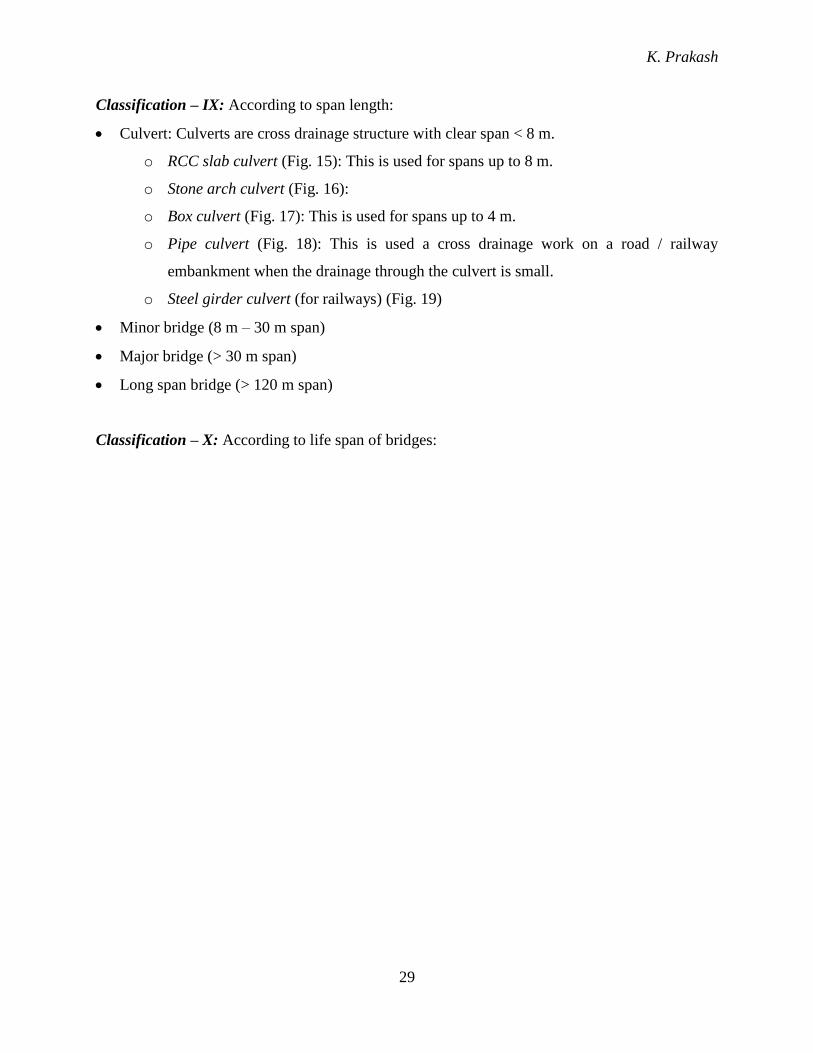
Cable stayed bridge (Fig. 7): It is a bridge whose deck is suspended by multiple cables that
run down to the main girder from one or more towers. These bridges are suitable in this span
range 200 – 900 m. Ex: The Stromsund Bridge, Sweden
Classification – IV: According to the span:
Simple bridge
Continuous bridge
Cantilever bridge. Ex: Howrah Bridge, Kolkata, India
Classification – V: According to the position of the bridge floor relative to super structure:
Deck bridge (Fig. 8): In this bridge, the road deck is carried on the top of the super structure
or on the top of the supporting girders.
Half-through bridge (Pony type bridge) (Fig. 9): In this bridge, the deck is provided at the
middle of the super structure or mid way between top and bottom beam flanges and the load
is transferred to the girder through the web of the girder.
Through bridge (Fig. 10): In this bridge, the deck is supported at the bottom of the super
structure or supported by the bottom beam flange of the main supporting girders provided on
either side.

K. Prakash
28
Classification – VI: According to the method of connecting different parts of the super structure
(For steel bridges):
Welded bridge
Riveted bridge
Pin connected bridge
Classification – VII: According to road level relative to highest flood level of the river below:
High level bridge (non-submersible bridge / under-flow bridge): This bridge is capable of
allowing the design flood discharge without getting submerged.
Submersible bridge (Over-flow bridge): These bridges are not subjected to submergence
under ordinary floods. However, during high floods, water spills over the deck of the bridge.
Note: Cause way: This is an elevated paved road formed between the retaining walls on
either sides, taken sufficiently deep to withstand scour action. During floods, water flows
over the road surface.
Classification – VIII: According to the method of clearance for navigation:
High level bridge
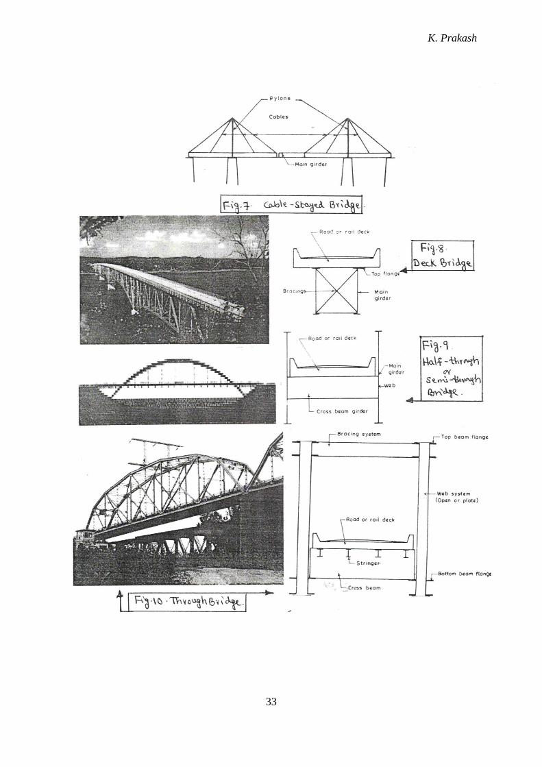
Movable – bascule bridge (Fig. 11): In this bridge, main girders are lifted together with the
deck about the hinge provided at one end of the span. Ex: London Tower Bridge, UK,
Railway Bridge at Mandapam near Rameshwaram, India
Movable – swing bridge (Fig. 12): In this bridge, the girders and the deck can be swung
about its middle over the middle pier, clearing the span on either side for the passage of
ships. Ex: Railway Bridge at Fort Madison, Iowa
Lift bridge (Fig. 13): In this bridge, gantries are provided at the piers on either end of the
span and entire girder and the floor system is lifted up by a hydraulic arrangement to the
extent required for the free passage of the ship. Ex: Cape Cod Canal Bridge at Buzzards
Bay, Massachusetts, USA; Road bridge across Mathanchery channel at Cochin.
Transporters bridge (Fig. 14)
K. Prakash
29
Classification – IX: According to span length:
Culvert: Culverts are cross drainage structure with clear span < 8 m.
o RCC slab culvert (Fig. 15): This is used for spans up to 8 m.
o Stone arch culvert (Fig. 16):
o Box culvert (Fig. 17): This is used for spans up to 4 m.
o Pipe culvert (Fig. 18): This is used a cross drainage work on a road / railway
embankment when the drainage through the culvert is small.
o Steel girder culvert (for railways) (Fig. 19)
Minor bridge (8 m – 30 m span)
Major bridge (> 30 m span)
Long span bridge (> 120 m span)
Classification – X: According to life span of bridges:

K. Prakash
30
Temporary bridge
Permanent bridge
Classification – XI: According to alignment:
Square bridge (Fig. 20): If the axis of the bridge is perpendicular to the axis of the stream
/ obstacle over which it is constructed, then such a bridge is called a square bridge.
Skew bridge (Fig. 21): If the axis of the bridge is not perpendicular to the stream /
obstacle over which it is constructed, then such a bridge is called a skew bridge.
Note:
Under bridge: It is a bridge constructed to allow a road to pass underneath. The top of
the bridge may be used for railway traffic or for laying pipe lines over the road.
Over bridge: It is a bridge constructed such that a road way is over the bridge and the
way beneath the bridge can be an obstacle or can be used for railway traffic.

K. Prakash
31

K. Prakash
32
K. Prakash
33
K. Prakash
34

K. Prakash
35
*~*~*~*

K. Prakash
36
Chapter – 4
DAMS
Introduction
A dam is an abstraction or a barrier built across a stream or a river. The side of the
dam on which water gets collected is called the upstream side and the other side of the dam is
called the downstream side. The water body formed on the upstream side of the dam is called
reservoir.
Various purposes of constructing a dam are:
to provide water for irrigation
to provide water supply facility to township
to generate hydroelectric power
to control floods
to create recreational facilities
to promote fisheries
to provide navigation facilities
to store wastes from mines (i.e., Tailing dams)
Classification of Dams
Classification I: Based on materials used for the construction:
Timber dam
Steel dam
Masonry / Concrete dam
Earth dam
Rockfill dam
Combined earth and rockfill dam
Classification II: Based on relative deformable capability:
Rigid dam
o Timber dam
o Steel dam
K. Prakash
37
o Concrete / Masonry dam
Non-rigid dam (Embankment dam)
o Earth dam
o Rockfill dam
o Combined earth and rockfill dam
Classification III: Based on hydraulic design of dam:
Overflow dam: It is a dam which is designed such that the surplus water in the reservoir
passes over its crest to the downstream side. These are also called spill ways. Ex: Bhakra
dam, Kabini dam.
Non-overflow dam: It is a dam where water will not flow over the top of the dam.
However, provision may be there to allow water from upstream side to downstream side
through sluices. Ex: KRS dam, Karnataka
Note: Most of the existing dams are combinations of overflow and non-overflow dams.
Classification IV: Based on structural behaviour
Gravity dam: This type of dam is design to resist the external forces such as water
pressure, uplift pressure etc., by the weight of the dam. Ex: Bhakra dam.
Arch dam: This type of dam is designed to transfer the water pressure acting on the dam
to its abutments by the arch action. Ex: Idikki dam, Kerala
Embankment dam: This type of dam resists the water pressure mainly by the shear
resistance in addition to its weight of the dam materials. Ex: earth dams, rock filled dams.
Classification V: Based on function
Storage dam: This dam is constructed to impound / store water during the periods of
surplus flow (i.e. floods), which can be used during lean flow period.
Diversion dam: This dam is constructed to raise the water level in the stream so that the
flow from a natural stream is diverted in to canals or other conveyance systems to the
place of use such as irrigation, power generation, navigation etc. This type of dam is also
called Weir or Barrage.
Detention dam: This dam is constructed to retard the flood flow and hence, to minimize
the sudden effects of floods. This can be of two types.

K. Prakash
38
o Water is temporarily stored and released gradually through an outlet structure
o Water is stored for a longer period with the sole intention of recharging the ground
water.
Debris dam: Main purpose of this dam is to trap the sediments in them. The tailing dam
is a type of debris dam which is used to store the wastes released from mining industry.
Ex: Lakhya dam, Kuduremukh.
Coffer dam: It is a temporary structure constructed to divert the water from the work site.
Note: The figures of some of the dam types are shown below:

K. Prakash
39
*~*~*~*