Embed Size (px)
Citation preview

Electronic Navigation Alternatives
Sherry McCampbell
s/v Soggy Paws 1
“What electronic navigation
tools should I be using to
navigate with as I go further
offshore?”
Or.. How to stay off the Rocks!

Avanti, Beveridge Reef, Aug 2017
“I had no idea the reef was there. I knew we’d
hit something and were taking on water.
We were ready to abandon ship.” Robbie Cooper, s/v Avanti, Beveridge Reef, September 2017
2

3
“Team Vestas Wind’s grounding on the Cargados
Carajos Shoals comes down to a basic failure in
overall passage planning, and an over-reliance on
electronic navigation.”
Vestas Wind
Cargado Shoals
2014

4
Tanda Malaika
Huahine
2017
“When they asked us what happened and we told them that our chart did
not show reef, they asked us if we had been using Navionics charts, and
I said yes. He then shook his head and said that at least five boats end
up on those reefs a year who were using Navionics charts.”

Moonshadow’s Close Call
5
We had
plotted a
route that
kept us
outside the
300-foot
depth
contours

Moonshadow’s Close Call
6
We looked up, and
to our horror found
that we were only
about 900 feet
from the surf!
Had it been
nighttime, we
almost certainly
would have ended
up in that surf

Side-by-Side Comparison
7

8
The coastal scale electronic chart supplied to USS Guardian was flawed due to
human error on the part of the NGA. This error mis-located the Tubbataha Reef
by 7.8 nautical miles from its actual location. NGA was aware of this error in 2011
and updated a smaller scale electronic chart, but failed to publish a correction for
the larger scale chart that the USS Guardian was using when she ran aground.
USS Guardian
Tubataha Reef
2010

NW Australia, June 2016 9

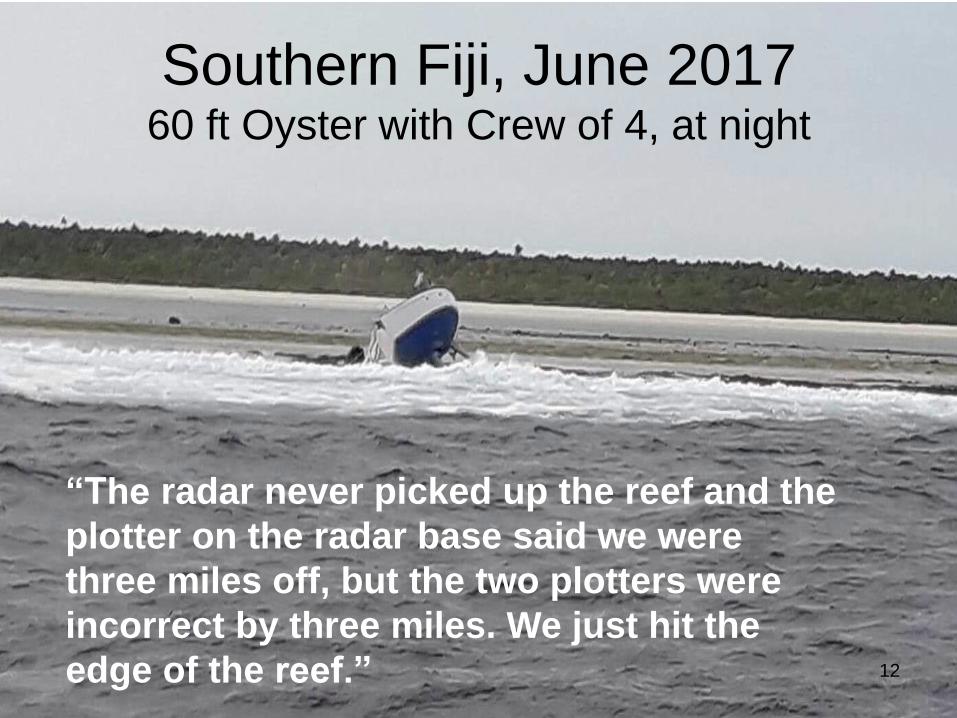
Southern Fiji, June 2017 60 ft Oyster with Crew of 4, at night
10
“They decided to go to Fiji instead of Tonga
because of an equipment failure, then
activated a distress beacon at 4am after
going aground on a reef”

Southern Fiji, June 2017 60 ft Oyster with Crew of 4, at night
11
The Kiwi owner of the yacht says his
nautical charts told him the reef was about
5km away - just before the boat hit it.
Southern Fiji, June 2017 60 ft Oyster with Crew of 4, at night
12
“The radar never picked up the reef and the
plotter on the radar base said we were
three miles off, but the two plotters were
incorrect by three miles. We just hit the
edge of the reef.”

Topics
• Be suspicious of your charts
• Why not to use your iPad / Android tablet as
your only navigation tool
• Why not to use your chartplotter as your only
navigation tool
• Paper vs Raster vs Vector vs Satellite Charts
• Validating the accuracy for the next stop
• Navigating at night
• Introducing the power of GE2KAP
• Introducing the power of OpenCPN Note: All tools and resources referenced in this presentation are
linked on the reference pages at the end. 13

Paper Charts
• Satisfyingly “there” feel
• Only as good as the survey they are
based on
• A pain in the ass to keep updated
• Bulky, expensive, hard to acquire
• Hard to store large quantities
• They can blow away, they can get wet
• But islands don’t disappear! 14

Traditional Raster Charts
• Essentially a scanned paper chart
• All paper chart info is retained
• Easiest to adjust to using (if you are
familiar with paper charts)
• Take up MUCH more electronic storage
space (vs Vector charts)
– 24 CD’s to cover the world, partially
• Everything zooms at the same rate
15

Raster vs Vector
16

Vector Charts
• Vector charts have been drawn from paper
charts by *someone*
• Are only as accurate as the underlying
chart they were made from
• Take up SIGNIFICANTLY less space on
electronic storage
– The Whole World in one folder
• Contain lines, “objects”, and “data”
17

Raster vs Vector
18

Vector Charts
• Most chart plotters are using vector charts
• Most tablet/phone apps are using vector
charts
• Take a significantly smarter program to
display and use
• Very powerful if used correctly
• Sometimes confusing to use and/or set up
(flexibility = complexity)
19

Too Much Detail! (this is configurable)
20

Problems with Vector Charts The Disappearing Island – Chart Zooms
21
Where is Suwarrow Atoll???

Problems with Vector Charts The Disappearing Island – Chart Zooms
22
Where is Suwarrow Atoll???
Turn On Chart Texts

Problems with Vector Charts The Disappearing Island – Chart Zooms
23
Turn On Chart Outlines
Where is Suwarrow Atoll???

Problems with Vector Charts The Disappearing Island – Chart Zooms
24
Zoom In
Where is Suwarrow Atoll???

Chart Zooms / Avanti Wreck From sv Golden Glow on Noonsite
“Beveridge Reef appears on our Furuno
Chart, but only when it’s zoomed in to a map
size of 35 nm across the screen (at 40 nm
size it’s NOT visible).
Navionics and iNavx apps DO show
Beverage Reef, but our Earthmate (Garmin)
app, the map for our delorme explorer
device, does NOT show the reef.”
25

The Disappearing Island Also Misplaced
26 Where is Suwarrow Atoll???
Oops! Navionics vs Cmap Accuracy

The Disappearing Island Misplaced
27 Where is Suwarrow Atoll???

The Disappearing Reef Chart Versions
28
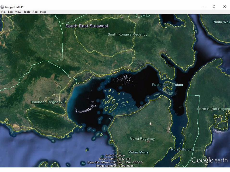
What’s Actually There
Reef Area South of Wakatobi
(Indonesia)

The Disappearing Reef Chart Versions
29
What Shows 2005 Charts

The Disappearing Reef Chart Versions
30
What Shows 2011 Charts !

Some Sources of
Vector Charts
• Your local country’s chart purveyor
– Sometimes free, sometimes not
• CM93 v2 (stopped updating in 2010/2011)
• CM93 v3 Cmap / Time Zero (Furuno)
• Garmin ($250-$350 per region)
• Navionics
• Raymarine
• Other Cruisers
• The Apple Store!
31
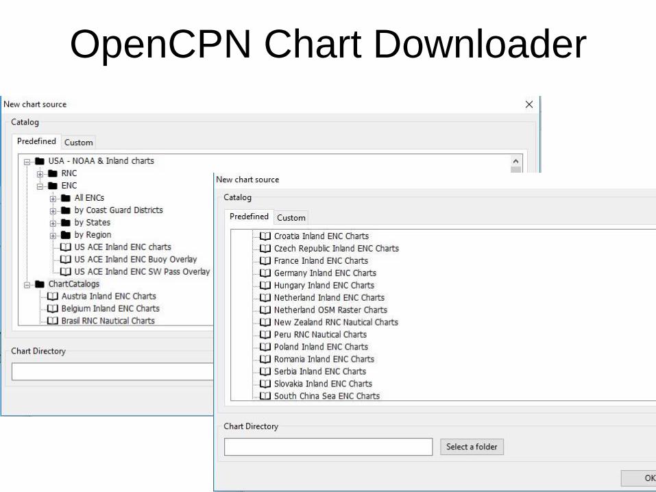
OpenCPN Chart Downloader
32

OpenCPN Chart Downloader
33

Example of Japan’s Chart Purchase Page 34

35
Pay-for Charts
from 3rd Party Vendors

Using Satellite “Charts”
• GoogleEarth (Windows only)
• SAS Planet (Windows only)
• Ovital Maps (Tablet only)
• OpenCPN & GE2KAP Charts (Windows,
Linux, Apple Mac, Android (tablet &
phone), sorry, not iPad or iPhone
• Some chartplotter chart sets
– Garmin G2 Vision (poor resolution)
36

Which Would You Choose?
37

Which Would You Choose?
38

Which Would You Choose?
39

Which Would You Choose?
40

Problems Using Satellite Programs Directly
• GoogleEarth
– No direct GPS connection
– You are not in control of the chart-saving
– Not made for navigation
– Integrating other navigation information
– You MUST download
• SASPlanet
– Can control what is saved
– Possible to populate from other’s saved data
– Not as user friendly
• Is chart there or not??? 41

Benefits of Using Pre-Made
Satellite KAP Charts
• You know absolutely what you have charted
• You can share your charts with others
• You know who made it and how well it is done
42

Steps to make a Chart from
GoogleEarth
• Install GE2KAP & GoogleEarth
(and/or SASPlanet)
• Locate area you want to chart
– Zoom in, position
– Make sure it is fully downloaded
– Turn Layers On and Off
– Get rid of toolbars (View /
43

44
Fully Downloaded

45

46
47

A Few Quick Settings Changes
48

Steps to make a Chart from
GoogleEarth/SAS Planet
• Open GE2KAP
• Select folder to save chart
• Name chart-to-be
• Click a button -> Creates a .kap file
(raster chart file)
• Tell your chart program to load it
49

GE2Kap is Simple!
50
Specify Path (to save chart) & filename, and click “Create Chart”

Advanced GE2KAP Features
• Make multiple charts along a course, or within a
circle--great for coastlines or rivers
• Adjust screen capture on GoogleEarth to cut off
the bottom stuff
• Merge multiple small charts into one big chart
• Overlay chart on OpenCPN (blended chart)
• Alternative to GE2KAP:
www.venturefarther.com 51

GoogleEarth vs SAS Planet
• GoogleEarth
– Easier to use (less flexibility)
– Updates may cause problems
– Limited to JUST Google imagery
– Infinite / specific altitude settings
– Many layers and overlay capabilities
52

GoogleEarth vs SAS Planet
• SAS Planet
– High flexibility
– Multiple imagery sources
– User interface is quirky
– Tiled area charts have dot in the middle
(a GE2KAP quirk)
– No longer being updated?
• You should check both when making
charts, for best imagery 53

Downloading & Installing
GoogleEarth & SASPlanet
• Use GoogleEarth Pro version from GE2KAP site
(newer GE version blocks GE2KAP api)
• Use SASPlanet version from Valhalla site
(pre-configured for GE2KAP settings)
54

GE2Kap & OpenCPN Tutorials
• Terry (Valhalla)
• Sherry (Soggy Paws)
• Embedded in GE2Kap
55
Sources of Pre-Made
GoogleEarth Charts
• Mike on Zen Again (world?)
• Terry on Valhalla (SE Asia & W Pac)
• Sherry on Soggy Paws (Fr Poly to SE Asia)
• Jon on Ocelot (SE Asia) (bring hard drive)
• Rally Groups (Puddle Jumpers)
• Other Cruisers’ hard drive swap
56

Choosing a Charting Program
• Are you held captive??
• Chartplotters = captive, expensive,
ruggedized
• Time Zero (ex Nobeltec) = captive,
expensive
• Most tablet apps = captive, cheap
• OpenCPN = OPEN!, free!
57

Benefits of OpenCPN
• Free, free, free
• Runs on almost everything (exc iPad )
• Supports many chart formats
• Great for sharing tracks and waypoints
(gpx)
• Permits adjustment to CM93 v2 Charts
• Good website and extensive help
• Many, many plug-ins to add functionality
58

As you move the cursor around the screen,
the data in the box changes
Open GRIB Plugin
Open GRIB File
Open GRIB Plugin
59

RTOFS (Grib File) Display
60 RTOFS = Grib file for current data

Climatology Plugin
• Pilot charts overlaid on your chart
• Updated with fairly recent data
• Wind, currents, and tropical storm tracks
• Traditional wind rose display, or wind barbs
“Climatology data is generally averaged since the 1980's
depending on data type and sources available (for
example, Wind data is averaged 6 hr data since 1987)”
61

Where is a Safe Place to Be In August?
62

More OpenCPN Plugins
• Radar overlay (Garmin & Navico)
• Weather Routing
• Create your Polar file
• Voyage Data Recorder
• Stowage Manager
• Logbook Function
• NMEA Instrument Display
• Squidio – Alternative to Active Captain
63

Rugged Laptops for OpenCPN
64
10 inch screen, $425
13 inch screen, $450
Free shipping
1.2 ghz processor
80 gb HDD
2 gb RAM
External GPS antenna
12 volt power supply
Linux OS
Pre-loaded w/ OpenCPN & some charts

Accuracy of the GPS
• Does your tablet HAVE a GPS?
(older wifi-only, maybe not)
– Recommended: Bad Elf Bluetooth GPS
• Backup/easy USB GPS for laptops
– GlobalSat BU-353-S4 USB GPS Receiver
• Windows 7, 8, 10
• Linux
• Rasberry Pi
• $27 on Amazon, with Prime
65

Accuracy of the GPS
• Understand the limitation of your GPS
• Time to acquire fix varies widely
– How many receivers it has (8,12,48 channels)
– How long since last use
– How far away from last use
– Signals blocked (cabin, trees, buidlings)
– Newer devices can perform significantly better
66

Android program “GPS Test”
67
METERS! Inside building
Marginal SNR
Not many sats

Android program “GPS Test”
68
METERS! Outside buildings
OK SNR
More sats

Android program “GPS Test”
69
What Satellites
to Display

Entering a new Area?
How to Check Your Chart
• Accuracy
– Plot a known set of waypoints
– GPX / Friend you trust / Satellite / Guidebook
• Detail
– Check vs other sources
• Plot route and check at low level
• If you change your route, check your
NEW route at low level
70
Entering a new Area?
What Charts to Use?
• ASK “what are the best charts for…”
• Make sure you validate
– Chartplotter, tablet, or computer
– What “generation” of chart
• Ask people who “go places”
• Harbor charts for busy ports are almost
always accurate everywhere
• The further off the beaten path, the more
likely the charts will be inaccurate 71
If You’re Stuck Navigating
Unfamiliar areas at Night
• Consider: Heave to and enter in daylight
• If you must go in…
– Prior prep makes this option much safer
• Satellite (GE) charts
• Trusted tracks and waypoints
– Check and double-check
– Charts, waypoints, routes, depths
– Use other validation methods
(radar, depth sounder)
– Mark I eyeballs! Spotlight at night
72

The Bottom Line
• Know the true accuracy of your GPS device
• Plot a detailed route and examine for anomalies
• If your route changes, examine it again
• Don’t sail around reefs at night
• Use all the tools available
– Paper charts
– Electronic charts from several sources
– GoogleEarth & other satellite charts
– Other cruiser’s tracks and waypoints
– Cruising guides 73

The Bottom Line
• Double check your waypoints
• One caution about “Electronic charts from
several sources (make sure they are different
sources)”
– The Grib File / Weather Forecast analogy
74

Copyright Dave McCampbell 2014
75
The End
www.SVSoggyPaws.com

Questions?
76

Sources of Charting Tools/Info
• Terry (Valhalla) Charts, Waypoints, Guides, etc
http://yachtvalhalla.net/navigation/terrystopics.htm
• Paul’s GE2Kap Program http://www.gdayii.ca/
• OpenCPN https://opencpn.org/
• Ovital Maps (iPad / Android)
http://www.ovital.com/en/
• Zen Again (Lots of Charts!) http://yachtzenagain.blogspot.com/2015/04/googleearth-
kap-library-for-opencpn-and.html
77

Sources of Charting Tools/Info
• Soggy Paws’ Website http://svsoggypaws.com/GECharts/index.htm Charts
http://svsoggypaws.com/Presentations.htm OpenCPN
• Garmin’s iPad Product (BlueChart) - Apple Store (Not currently available on Android )
• Navionics Apps (iPad & Android) – Apple Store & Google Play
• USB GPS for Laptops Amazon Link
• Ruggedized PC’s equipped with OpenCPN & GPS Gary Rogers [email protected] or text at 239-633-5714
• Navigating with SAS Planet Directly http://outchasingstars.com/2017/07/15/using-sas-planet-navigate-
uncharted-reefs/ 78

Other Background Information
• https://www.thoughtco.com/raster-vs-vector-charts-
2915534
• https://www.nauticalcharts.noaa.gov/csdl/seamlessraster
.html
79