Embed Size (px)
Citation preview
Elaho Feasibility Study – March 2017
1 | P a g e
Elaho Rock Jam Removal Feasibility Study
Photo credit: Francesca Knight
Prepared by: E.B. Tobe Enterprises P.O. Box 138 Brackendale, British Columbia V0N 1H0 Prepared for: Squamish Nation 415 West Esplanade North Vancouver, British Columbia V7M 1A6 March 20, 2017

Elaho Feasibility Study – March 2017
2 | P a g e
This page intentionally blank.
Elaho Feasibility Study – March 2017
3 | P a g e
“Salmon, swimming through
box canyons and ancient rock, spawns eternal life.”
Haiku by Edith Tobe
Photo credit: Elko Jones Photography
Elaho Feasibility Study – March 2017
4 | P a g e
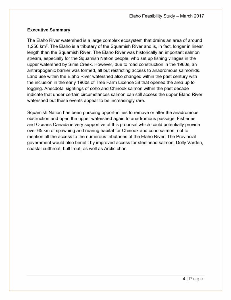
Executive Summary The Elaho River watershed is a large complex ecosystem that drains an area of around 1,250 km2. The Elaho is a tributary of the Squamish River and is, in fact, longer in linear length than the Squamish River. The Elaho River was historically an important salmon stream, especially for the Squamish Nation people, who set up fishing villages in the upper watershed by Sims Creek. However, due to road construction in the 1960s, an anthropogenic barrier was formed, all but restricting access to anadromous salmonids. Land use within the Elaho River watershed also changed within the past century with the inclusion in the early 1960s of Tree Farm Licence 38 that opened the area up to logging. Anecdotal sightings of coho and Chinook salmon within the past decade indicate that under certain circumstances salmon can still access the upper Elaho River watershed but these events appear to be increasingly rare. Squamish Nation has been pursuing opportunities to remove or alter the anadromous obstruction and open the upper watershed again to anadromous passage. Fisheries and Oceans Canada is very supportive of this proposal which could potentially provide over 65 km of spawning and rearing habitat for Chinook and coho salmon, not to mention all the access to the numerous tributaries of the Elaho River. The Provincial government would also benefit by improved access for steelhead salmon, Dolly Varden, coastal cutthroat, bull trout, as well as Arctic char.
Elaho Feasibility Study – March 2017
5 | P a g e
Table of Contents Executive Summary ........................................................................................................ 4
Abbreviations .................................................................................................................. 8
Acknowledgments ........................................................................................................... 9
Purpose of Study ........................................................................................................... 10
Section I – Project Scope and Existing Conditions ........................................................ 12
1.0 Location ............................................................................................................... 12
2.0 Background ......................................................................................................... 13
3.0 Land Use in the Elaho River Watershed .............................................................. 13
4.0 Fisheries in the Elaho River Watershed ............................................................... 15
4.1 Upper Elaho Minnow Trapping, Summer 2005 ................................................ 19
4.2 Elaho Minnow Trapping, Dec 2016 .................................................................. 20
5.0 eDNA Sampling ................................................................................................... 28
5.1 eDNA Sampling Explained: .............................................................................. 28
5.2 eDNA Persistence in Water:............................................................................. 29
5.3 Reliability of the eDNA Method: ....................................................................... 29
5.4 Elaho eDNA sampling program: ....................................................................... 31
Section II – Recommendation on Improvements for Fisheries Access ......................... 33
6.0 Restoration Prescriptions and Recommendations ............................................... 33
6.1 Initial Site Survey and Monitoring ..................................................................... 33
6.2 Timing .............................................................................................................. 34
7.0 Supporting Documentation .................................................................................. 35
8.0 References and Bibliography .................................................................................. 40
Appendix I Forestry and Logging in the Elaho Watershed ............................................ 43
Appendix II Geology of the Elaho Valley ....................................................................... 45
Appendix III Hydrometric Data ...................................................................................... 48
Appendix IV Mining in the Elaho Watershed ................................................................. 49
Appendix V Recreation .................................................................................................. 49
Appendix VI Fish species in the Elaho River ................................................................. 50
Chinook Salmon (Oncorhynchus tshawytscha) ...................................................... 50
Coho Salmon (Oncorhynchus kisutch) ................................................................... 50
Pink Salmon (Oncorhynchus gorbuscha) ............................................................... 51
Chum Salmon (Oncorhynchus keta) ...................................................................... 52
Steelhead and Rainbow Trout (Oncorhynchus mykiss) ......................................... 52
Elaho Feasibility Study – March 2017
6 | P a g e
Arctic Char (Salvelinus alpinus) ............................................................................. 53
Bull Trout (Salvelinus confluentus) ......................................................................... 53
Coastal Cutthroat Trout (Oncorhynchus clarki clarki) ............................................. 54
Dolly Varden (Salvelinus malma) ........................................................................... 54
Appendix VII Protected Areas in the Elaho Valley ......................................................... 55
Xay Temixw Land Use Plan ................................................................................... 55
a) Nsiiwx-nitem tl’a sutich .............................................................................. 55
b) Nexw-áyantsut ........................................................................................... 56
c) Esté-tiwilh .................................................................................................. 56
d) Clendinning Provincial Park ....................................................................... 57
e) Upper Elaho Valley Conservancy .............................................................. 57
Appendix VIII Recent Time Line for the Elaho Valley .................................................... 59
Appendix IX Skwxwú7mesh Uxwumixw time and place, culture history and paleoenvironments ........................................................................................................ 60
Appendix X Additional Site Maps .................................................................................. 61

Elaho Feasibility Study – March 2017
7 | P a g e
Tables:
Table 1. Steelhead releases in Elaho River .................................................................. 18
Table 2. Fish trapping results from July 28, 2005 .......................................................... 19
Table 3. Fish sampling and water quality results December 1, 2016. ........................... 20
Table 4: Proposed 2017 eDNA sampling program for the Elaho River. ........................ 31
Table 5. Detailed Work Schedule .................................................................................. 34
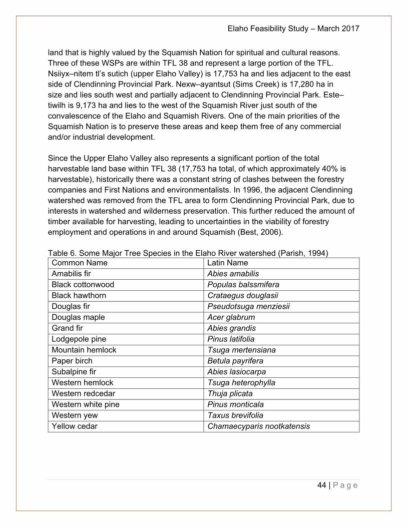
Table 6. Some Major Tree Species in the Elaho River watershed (Parish, 1994) ......... 44
Table of Figures:
Figure 1. Site map of Elaho Valley (original map downloaded from Google Earth) ....... 11
Figure 2. S2S LRMP Squamish Nation Wildlife Focus Areas ........................................ 15
Figure 3. Fish trap sites on the Upper Elaho River (original map downloaded from Google Earth) ................................................................................................................ 21
Figure 4. Mean daily river flow (1955 to 1990) .............................................................. 48
Figure 5. Squamish Nation wild spirit places (MOE, 2008) ........................................... 57
Figure 6. Protected Parks .............................................................................................. 58
Figure 7. Squamish Nation Wild Spirit Places and Sensitive Areas (MOE, 2008) ......... 61
Figure 8. Squamish Nation Cultural Sites in the Elaho Valley (MOE, 2008) .................. 62
Figure 9. Elaho Wildfire, August 2015 ........................................................................... 63
Figure 10. Randy Stoltmann Wilderness Area publication from spring 1995 ................. 67
Elaho Feasibility Study – March 2017
8 | P a g e
Abbreviations AAC – Allowable Annual Cut CERG – Cascade Environmental Resource Group DFO – Department of Fisheries and Oceans Canada ISFR – InStream Fisheries Research Inc Interfor – International Forest Products LRMP – Land and Resource Management Plan MOE – Ministry of Environment RGS – Regional Geochemical Survey S2S LRMP – Sea to Sky Land and Resource Management Plan TFL – Tree Farm Licence WCWC – Western Canada Wilderness Committee WSP – Wild Spirit Places
Elaho Feasibility Study – March 2017
9 | P a g e
Acknowledgments The document was prepared by EB Tobe Enterprises with the assistance and support of Squamish Nation members, particularly Randall Lewis. The contents of the document are a collaboration of efforts from Francesca Knight, as well as Caroline Melville and LJ Wilson and InStream Fisheries Research Inc. Special thanks go to Steve Rochetta (Ministry of Forests, Lands and Natural Resource Operations), Matt Foy (retired Fisheries and Oceans Canada), and Dave Nanson (Fisheries and Oceans Canada) for their added supporting documentation and anecdotal references. Additional artwork by Rhonda O’Grady.

Elaho Feasibility Study – March 2017
10 | P a g e
Purpose of Study Historically the Elaho River was an important fishery and food source for the Squamish Nation, who would set summer camp sites to capture Chinook salmon (Oncorhynchus tshawytscha) in the upper watershed. In the early 1960s the area was included as part of Tree Forest Licence 38 and shortly thereafter, in 1963, a logging road was constructed to access the Elaho Valley to harvest timber. The road construction resulted in rock and debris falling into the Elaho River, effectively creating an anadromous obstruction approximately 3 km above the confluence with the Squamish River. During the past 20 years, there has been dialogue around making changes to the rock obstruction to improve anadromous fisheries access into the upper Elaho River. Studies were done on stream and lake classification of the tributaries of the Elaho River in the 1980s and 1990s that included fish trapping, restoration recommendations, photo documentation, and background information on the area (Nelson, 1991). However, no specific recommendations were made regarding the best approach to improve fish access. Along with historical anecdotal accounts of Chinook and coho salmon (O. kisutch) reaching the upper Elaho River watershed, there were also sightings of coho and Chinook salmon observed above the obstruction in recent years by provincial ministry staff (Rochetta, pers. comm.). Further to discussions with the federal government and provincial government with Squamish Nation, agreement was reached in 2016 to explore methods to improve anadromous access to the upper Elaho River watershed, specifically around the rock obstruction. This report, the ”Elaho River Rock Jam Feasibility Study”, provides background information on the history of the area including the fishery, geology, forestry, mining, hydrology, and recreation uses of the Elaho River watershed along with the next steps to take to improve conditions for fish access around the rock obstruction. The report is broken down into two sections plus appendices. Section I provides details on the project scope, previous sampling undertaken in the Elaho for fisheries (including water quality monitoring data), and what the conditions of the river are currently. The sampling program includes setting fish traps to identify fish presence and potential distribution, testing water samples in suitable locations for environmental DNA (eDNA), water quality monitoring, and establishing base-line data. Section II provides prescriptions and the steps needed to provide recommendations for how to improve fish access into the upper watershed. The appendices provide supporting documentation and background information collected on the Elaho River watershed.

Elaho Feasibility Study – March 2017
11 | P a g e
Figure 1. Site map of Elaho Valley (original map downloaded from Google Earth)
Elaho Feasibility Study – March 2017
12 | P a g e
Section I – Project Scope and Existing Conditions 1.0 Location
The Elaho River, (Watershed Code 900-097600-70400; FISS map #92J03; UTM 10 472269E 5550891N) has a length of 65 km and a watershed drainage area of 1,250 m2. It is located 52 km upstream of the confluence of the Squamish River into Howe Sound. Two major tributary systems, Sims Creek and Clendinning1 Creek, discharge into the Elaho River (Figure 1). The Elaho River watershed is within the traditional territory of the Squamish Nation and within Tree Farm Licence 38. The watershed is located primarily within two biogeoclimatic zones, the lower elevations within the watershed are within the Coastal Western Hemlock biogeoclimatic zone and the upper elevations and alpine are within the Mountain Hemlock biogeoclimatic zone. Access to the upper Elaho River watershed opened to logging in the early 1960s after logging road construction extended into the valley. The road construction into the Elaho River watershed caused boulder and rock debris to enter the mainstem channel of the river, approximately 3 km above the confluence with the Squamish River, resulting in an
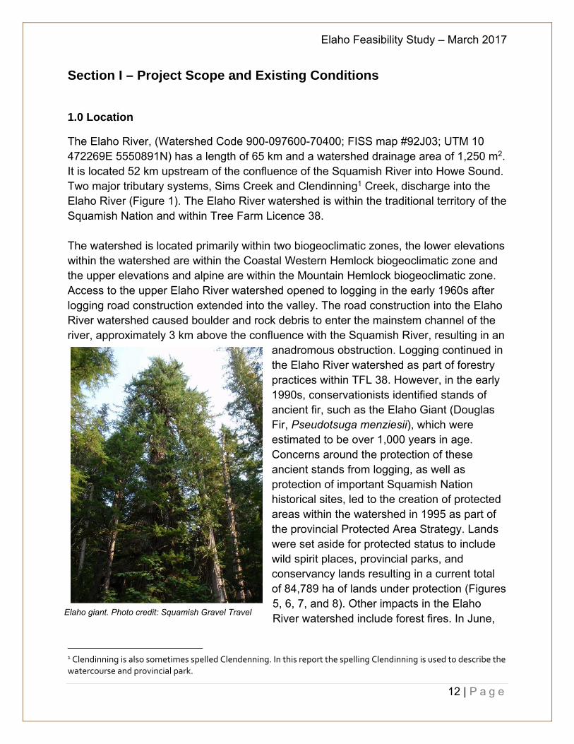
anadromous obstruction. Logging continued in the Elaho River watershed as part of forestry practices within TFL 38. However, in the early 1990s, conservationists identified stands of ancient fir, such as the Elaho Giant (Douglas Fir, Pseudotsuga menziesii), which were estimated to be over 1,000 years in age. Concerns around the protection of these ancient stands from logging, as well as protection of important Squamish Nation historical sites, led to the creation of protected areas within the watershed in 1995 as part of the provincial Protected Area Strategy. Lands were set aside for protected status to include wild spirit places, provincial parks, and conservancy lands resulting in a current total of 84,789 ha of lands under protection (Figures 5, 6, 7, and 8). Other impacts in the Elaho River watershed include forest fires. In June,
1 Clendinning is also sometimes spelled Clendenning. In this report the spelling Clendinning is used to describe the watercourse and provincial park.
Elaho giant. Photo credit: Squamish Gravel Travel
Elaho Feasibility Study – March 2017
13 | P a g e
2015 a massive fire devastated over 12,500 ha of prime timber lands (Figure 9). This was by no means the only forest fire to occur in the region but by far is the largest known on record. The last major forest fire was in the summer of 2005, and it was a fraction of the 2015 devastation.
2.0 Background Canadian Colliers first began logging the Elaho valley in 1961 in TFL 38 and in 1963 Weldwood of Canada Ltd. took over the operations and extended the logging road to the mouth of the Elaho River (Hancock, 1986). The intention was to provide access to the upper watershed for logging but other benefits included increasing access to recreational activities including fishing (Levy, 1997). In 1964 the TFL was acquired by Weldwood of Canada Limited. In 1995 International Forest Products took over management of the TFL and in December 2005 Squamish Nation acquired TFL 38. In 1994 individuals, such as Randy Stoltmann and John Clarke, mapped out one of the largest in tact wilderness areas near Vancouver that was dubbed the Randy Stotlmann Wilderness Area (refer to Figure 10). In 1996 this transformed into Clendinning Provincial Park and in 2007 the Upper Elaho Valley Conservancy (Figure 7). However, prior to this, in the summers of 1998 and 1999, logging in the Elaho valley became contentious as environmental protests were organized to raise awareness about old growth stands of timber, including Douglas Fir and Western Red Cedar. Randy Stoltmann and John Clarke and the Western Canada Wilderness Committee, working with Squamish Nation, helped to establish and secure what would become significant protected lands in the Elaho watershed including wild spirit places, provincial parks, and other conservancy lands.
3.0 Land Use in the Elaho River Watershed
The entire Elaho River watershed is within the Squamish Nation Territorial Lands. As noted by Randall Lewis (pers. comm. 2016), Squamish Nation traditional oral knowledge has been passed down through generations about the Elaho Valley. Historically, the main mode of transportation was by ocean and river canoes and the Elaho Valley was a very important and strategic area for defence. The last war Squamish Nation fought was in the mid to late 1600s in retaliation from trespass by Interior Salish Tsilhqot’in people (Chilcotin). The access through the Elaho Valley, from Pemberton and the Upper Lillooet River was referred by Squamish Nation as their “back door”. Squamish Nation tribes lived in the upper watershed to protect their interests. The warriors who died in battle were buried in the areas that are now protected as part
Black-cap chickadee
Elaho Feasibility Study – March 2017
14 | P a g e
of the “Wild Spirit Places”. Carbon dating artefacts place Squamish Nation in areas of historic villages to over 10,000 years ago (Nahanee, pers. comm.). Chief Bill Williams, a Squamish Nation Elder who currently sits on Squamish Nation Chief and Council, recalls stories from his Elders of salmon in the upper watershed. Oral history has also been passed down mentioning a Chinook camp that was located by Sims Creek. Chief Ian Campbell’s grandfather, Lawrence Baker, used to fish in the upper Elaho River at a Chinook fishing camp where an entire village was located, likely during the summer months, where the fish were predominant. Aside from logging, other resource and industrial uses in the watershed include a small quarry approximately 7.5 km above the confluence of the Squamish River by Quarry Pacific Industries for mining of quartz diorite phase of the Coastal Plutonic Complex in the rock (Hora, 1994). Current and historical non-industrial uses of the watershed consist of various recreation pursuits including hiking, camping, climbing, kayaking, and fishing. River rafting is also popular below the Devil’s Elbow. Some hunting also takes place in the watershed, predominantly for black-tailed deer, mountain goats, and black bear. As noted on Figure 2 the Elaho watershed is populated by deer, moose, elk, grizzly bear, mountain goats, and other fur animals. Part of the Provincial ministry’s objectives to maintain non-consumptive use (i.e. no hunting) is to protect the moose population and in 1988 a Moose Management Zone of critical moose habitat was identified in the Elaho drainage. This included protection of the winter range by forestry management practices allowing no more than 30% of the operable area in this Zone to contain stands aged between 1 and 20 years and to maintain at least 20% of the Zone in stands aged 61 years or more (Pedersen, 1998).

Elaho Feasibility Study – March 2017
15 | P a g e
Figure 2. S2S LRMP Squamish Nation Wildlife Focus Areas Efforts by Squamish Nation and others to protect portions of the Elaho watershed resulted in the creation of lands protected from logging, including the current wild spirit places, provincial parks, and conservancy lands. The Clendinning Provincial Park, created in 1996, protects 30,330 hectares. The Upper Elaho Valley Conservancy, created in 1998, protects an additional 10,253 hectares of land. The Sea to Sky Land and Resource Management Plan (LRMP) was instrumental in establishing an additional 44,000 hectares of protected lands as part of the Squamish Nation’s Wild Spirit Places (WSP).
4.0 Fisheries in the Elaho River Watershed
The Elaho River is defined by various landmarks including the confluence with the Squamish River, the lower canyon, the Devil’s Elbow, the anadromous obstruction (which is the focus of this report), the G-Main Road bridge (approximately 10 km above the confluence with the Squamish River), the Upper Elaho River (above the G-Main Road bridge) the E-Main Road, and the major tributaries of Clendinning River and Sims Creek. From 1997 to 2000 several studies were conducted in the Elaho River watershed to:
1) Identify fish bearing streams; 2) Locate obstructions to the upstream migration of juvenile and adult salmonids;
Elaho Feasibility Study – March 2017
16 | P a g e
3) Determine the presence or absence of fish in the stream sections above identified obstructions to fish passage; and
4) Determine the presence or absence of fish in any headwater lakes that exist on the streams sampled (Raven, 1997).
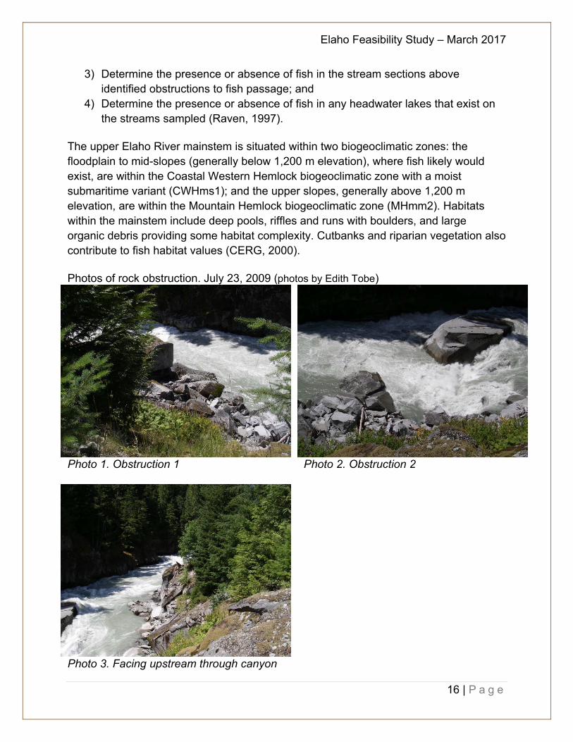
The upper Elaho River mainstem is situated within two biogeoclimatic zones: the floodplain to mid-slopes (generally below 1,200 m elevation), where fish likely would exist, are within the Coastal Western Hemlock biogeoclimatic zone with a moist submaritime variant (CWHms1); and the upper slopes, generally above 1,200 m elevation, are within the Mountain Hemlock biogeoclimatic zone (MHmm2). Habitats within the mainstem include deep pools, riffles and runs with boulders, and large organic debris providing some habitat complexity. Cutbanks and riparian vegetation also contribute to fish habitat values (CERG, 2000). Photos of rock obstruction. July 23, 2009 (photos by Edith Tobe)
Photo 1. Obstruction 1 Photo 2. Obstruction 2
Photo 3. Facing upstream through canyon

Elaho Feasibility Study – March 2017
17 | P a g e
November 2016 (Photos by Francesca Knight)
Photo 4. Facing south from road
Photo 5. Obstruction 1 Photo 6. Obstruction 2 Historical anecdotal recollections from Squamish Nation, dating back generations, clearly indicate active fishing in the upper Elaho River for Chinook salmon, coho salmon, and other species (pers. comm. R. Lewis). Despite this historical knowledge, the Provincial government did not consider the upper Elaho River to be fish-bearing, based on limited sampling work, and from 1985 to 1990 released juvenile steelhead (Oncorhynchus mykiss) into the drainage as part of a steelhead stocking program (van Dishoeck, 2000). Various studies and fish trapping have been undertaken since that time with rainbow trout (O. mykiss) being the predominant species captured. These rainbow trout are likely the residualized transplanted steelhead. Enhancement data provided by the Salmon Enhancement Program (DFO) summarized the releases of steelhead trout fry raised at Tenderfoot Hatchery in the Elaho River in
Elaho Feasibility Study – March 2017
18 | P a g e
Table 1 below (Levy, 1997). Tenderfoot Hatchery ceased raising steelhead fry in 1990 for the upper Squamish (and 1992 for Ashlu Creek and Mamquam River). Table 1. Steelhead releases in Elaho River Year River # Fed Fry Released 1988 Elaho River 29,017 1989 Elaho River 53,219 1990 Elaho River 43,359
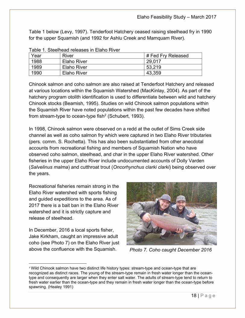
Chinook salmon and coho salmon are also raised at Tenderfoot Hatchery and released at various locations within the Squamish Watershed (MacKinlay, 2004). As part of the hatchery program otolith identification is used to differentiate between wild and hatchery Chinook stocks (Beamish, 1995). Studies on wild Chinook salmon populations within the Squamish River have noted populations within the past few decades have shifted from stream-type to ocean-type fish2 (Schubert, 1993). In 1998, Chinook salmon were observed on a redd at the outlet of Sims Creek side channel as well as coho salmon fry which were captured in two Elaho River tributaries (pers. comm. S. Rochetta). This has also been substantiated from other anecdotal accounts from recreational fishing and members of Squamish Nation who have observed coho salmon, steelhead, and char in the upper Elaho River watershed. Other fisheries in the upper Elaho River include undocumented accounts of Dolly Varden (Salvelinus malma) and cutthroat trout (Oncorhynchus clarki clarki) being observed over the years. Recreational fisheries remain strong in the Elaho River watershed with sports fishing and guided expeditions to the area. As of 2017 there is a bait ban in the Elaho River watershed and it is strictly capture and release of steelhead. In December, 2016 a local sports fisher, Jake Kirkham, caught an impressive adult coho (see Photo 7) on the Elaho River just above the confluence with the Squamish.
2 Wild Chinook salmon have two distinct life history types: stream-type and ocean-type that are recognized as distinct races. The young of the stream-type remain in fresh water longer than the ocean-type and consequently are larger when they enter salt water. The adults of stream-type tend to return to fresh water earlier than the ocean-type and they remain in fresh water longer than the ocean-type before spawning. (Healey 1991)
Photo 7. Coho caught December 2016
Elaho Feasibility Study – March 2017
19 | P a g e
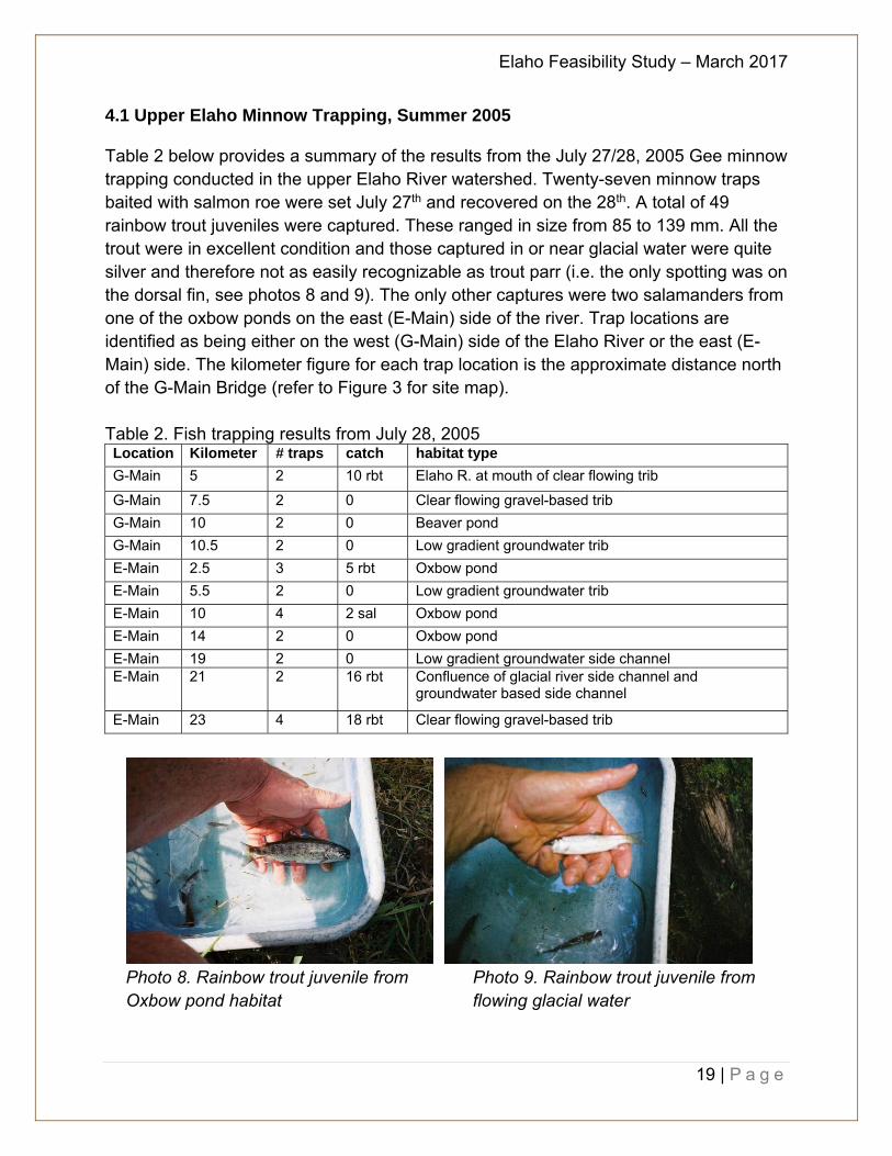
4.1 Upper Elaho Minnow Trapping, Summer 2005
Table 2 below provides a summary of the results from the July 27/28, 2005 Gee minnow trapping conducted in the upper Elaho River watershed. Twenty-seven minnow traps baited with salmon roe were set July 27th and recovered on the 28th. A total of 49 rainbow trout juveniles were captured. These ranged in size from 85 to 139 mm. All the trout were in excellent condition and those captured in or near glacial water were quite silver and therefore not as easily recognizable as trout parr (i.e. the only spotting was on the dorsal fin, see photos 8 and 9). The only other captures were two salamanders from one of the oxbow ponds on the east (E-Main) side of the river. Trap locations are identified as being either on the west (G-Main) side of the Elaho River or the east (E-Main) side. The kilometer figure for each trap location is the approximate distance north of the G-Main Bridge (refer to Figure 3 for site map).
Table 2. Fish trapping results from July 28, 2005 Location Kilometer # traps catch habitat type
G-Main 5 2 10 rbt Elaho R. at mouth of clear flowing trib
G-Main 7.5 2 0 Clear flowing gravel-based trib
G-Main 10 2 0 Beaver pond
G-Main 10.5 2 0 Low gradient groundwater trib
E-Main 2.5 3 5 rbt Oxbow pond
E-Main 5.5 2 0 Low gradient groundwater trib
E-Main 10 4 2 sal Oxbow pond
E-Main 14 2 0 Oxbow pond
E-Main 19 2 0 Low gradient groundwater side channel E-Main 21 2 16 rbt Confluence of glacial river side channel and
groundwater based side channel
E-Main 23 4 18 rbt Clear flowing gravel-based trib
Photo 8. Rainbow trout juvenile from Photo 9. Rainbow trout juvenile from Oxbow pond habitat flowing glacial water
Elaho Feasibility Study – March 2017
20 | P a g e
4.2 Elaho Minnow Trapping, Dec 2016
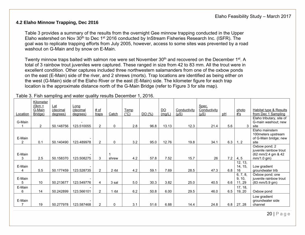
Table 3 provides a summary of the results from the overnight Gee minnow trapping conducted in the Upper Elaho watershed on Nov 30th to Dec 1st 2016 conducted by InStream Fisheries Research Inc. (ISFR). The goal was to replicate trapping efforts from July 2005, however, access to some sites was prevented by a road washout on G-Main and by snow on E-Main. Twenty minnow traps baited with salmon roe were set November 30th and recovered on the December 1st. A total of 3 rainbow trout juveniles were captured. These ranged in size from 42 to 83 mm. All the trout were in excellent condition. Other captures included three northwestern salamanders from one of the oxbow ponds on the east (E-Main) side of the river, and 2 shrews (morts). Trap locations are identified as being either on the west (G-Main) side of the Elaho River or the east (E-Main) side. The kilometer figure for each trap location is the approximate distance north of the G-Main Bridge (refer to Figure 3 for site map).
Table 3. Fish sampling and water quality results December 1, 2016.
Location
Kilometer (0km = G-Main Bridge)
Lat (decimal degrees)
Long (decimal degrees)
# of traps Catch
Temp (°C) DO (%)
DO (mg/L)
Conductivity (µS)
Spec. Conductivity (µS) pH
photo #'s
Habitat type & Results from Dec 1 Sampling
G-Main 1 2 50.148756
-123.510055 2 0 2.8 96.8 13.13 12.3 21.4 5.6 3
Elaho tributary, site of G-main washout; new site
E-Main 2 0.1 50.140490
-123.489978 2 0 3.2 95.0 12.76 19.8 34.1 6.3 1, 2
Elaho mainstem 100meters upstream of G-Main bridge; new site
E-Main 3 2.5 50.158370
-123.508275 3
1 shrew 4.2 57.8 7.52 15.7 26 7.2 4, 5
Oxbow pond; 2 juvenile rainbow trout (62 mm/2.4 gm & 42 mm/1.0 gm)
E-Main 4 5.5 50.177459
-123.528735 2 2 rbt 4.2 59.1 7.69 28.5 47.3 6.8
12, 13, 14, 15, 16
Low gradient groundwater trib
E-Main 5 10 50.213677
-123.549776 4 3 sal 5.0 30.3 3.82 25.0 40.5 6.6
6, 7, 8, 9, 10, 11, 29
Oxbow pond; one juvenile rainbow trout (83 mm/5.9 gm)
E-Main 6 14 50.242899
-123.566101 2 1 rbt 6.2 50.8 6.00 29.5 46.0 6.5
17, 18, 19, 20 Oxbow pond
E-Main 7 19 50.277978
-123.587468 2 0 3.1 51.6 6.88 14.4 24.8 6.8 27, 28
Low gradient groundwater side channel

Elaho Feasibility Study – March 2017
21 | P a g e
E-Main 8 21 50.292091
-123.576947 3
1 shrew 4.6 72.8 9.16 36.2 59.2 6.8
21, 22, 23, 24, 25, 26
Confluence of glacial river side channel and groundwater based side channel
E-Main 9 23
Clear flowing gravel-based trib; site not used
Abbreviations:
Rbt: rainbow trout Sal: salamander
Figure 3. Fish trap sites on the Upper Elaho River (original map downloaded from Google Earth)
Elaho Feasibility Study – March 2017
22 | P a g e
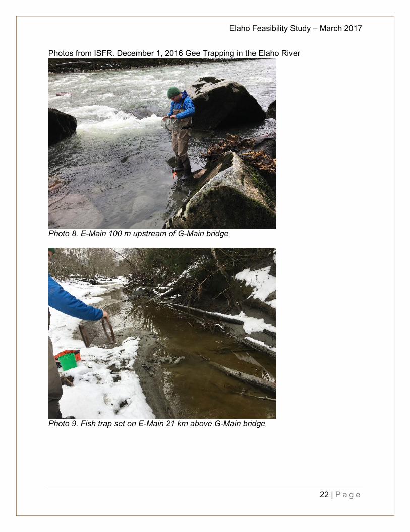
Photos from ISFR. December 1, 2016 Gee Trapping in the Elaho River
Photo 8. E-Main 100 m upstream of G-Main bridge
Photo 9. Fish trap set on E-Main 21 km above G-Main bridge
Elaho Feasibility Study – March 2017
23 | P a g e
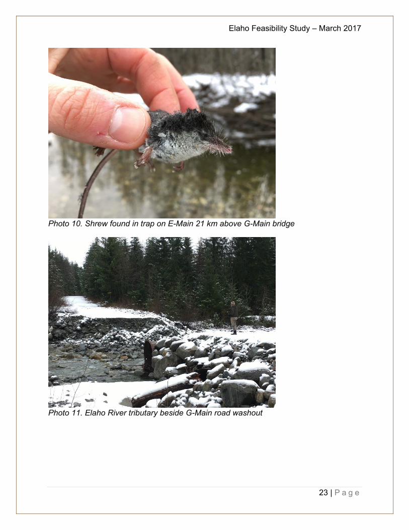
Photo 10. Shrew found in trap on E-Main 21 km above G-Main bridge
Photo 11. Elaho River tributary beside G-Main road washout
Elaho Feasibility Study – March 2017
24 | P a g e
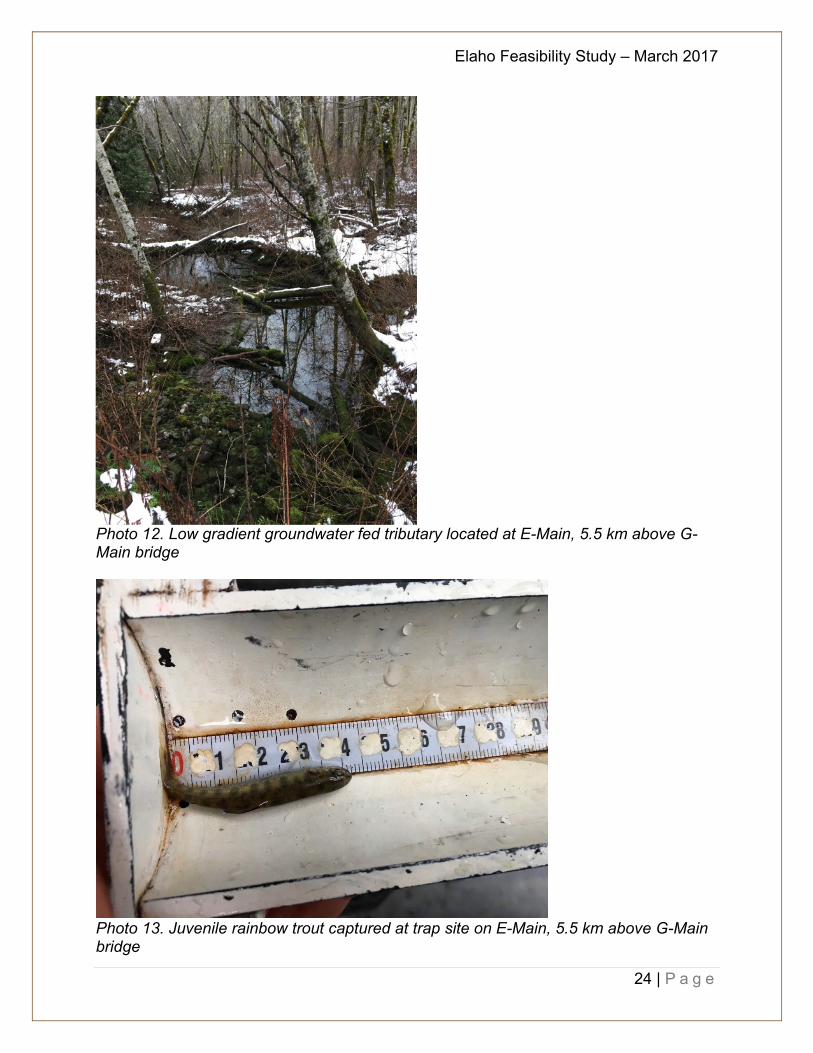
Photo 12. Low gradient groundwater fed tributary located at E-Main, 5.5 km above G-Main bridge
Photo 13. Juvenile rainbow trout captured at trap site on E-Main, 5.5 km above G-Main bridge
Elaho Feasibility Study – March 2017
25 | P a g e
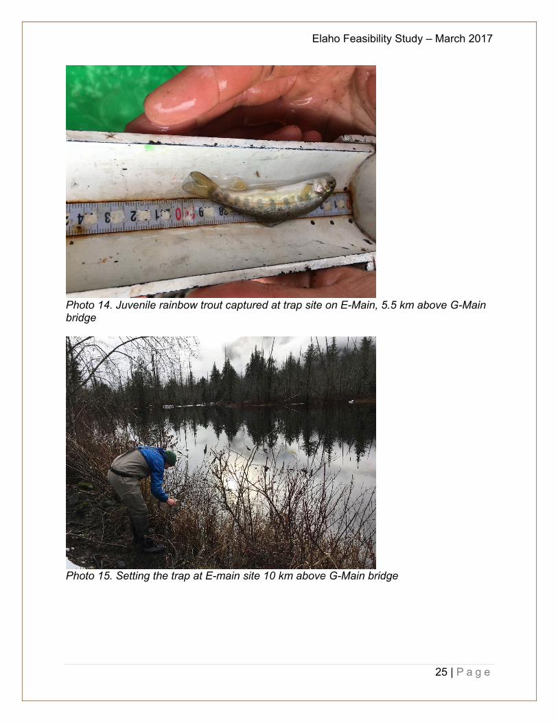
Photo 14. Juvenile rainbow trout captured at trap site on E-Main, 5.5 km above G-Main bridge
Photo 15. Setting the trap at E-main site 10 km above G-Main bridge
Elaho Feasibility Study – March 2017
26 | P a g e
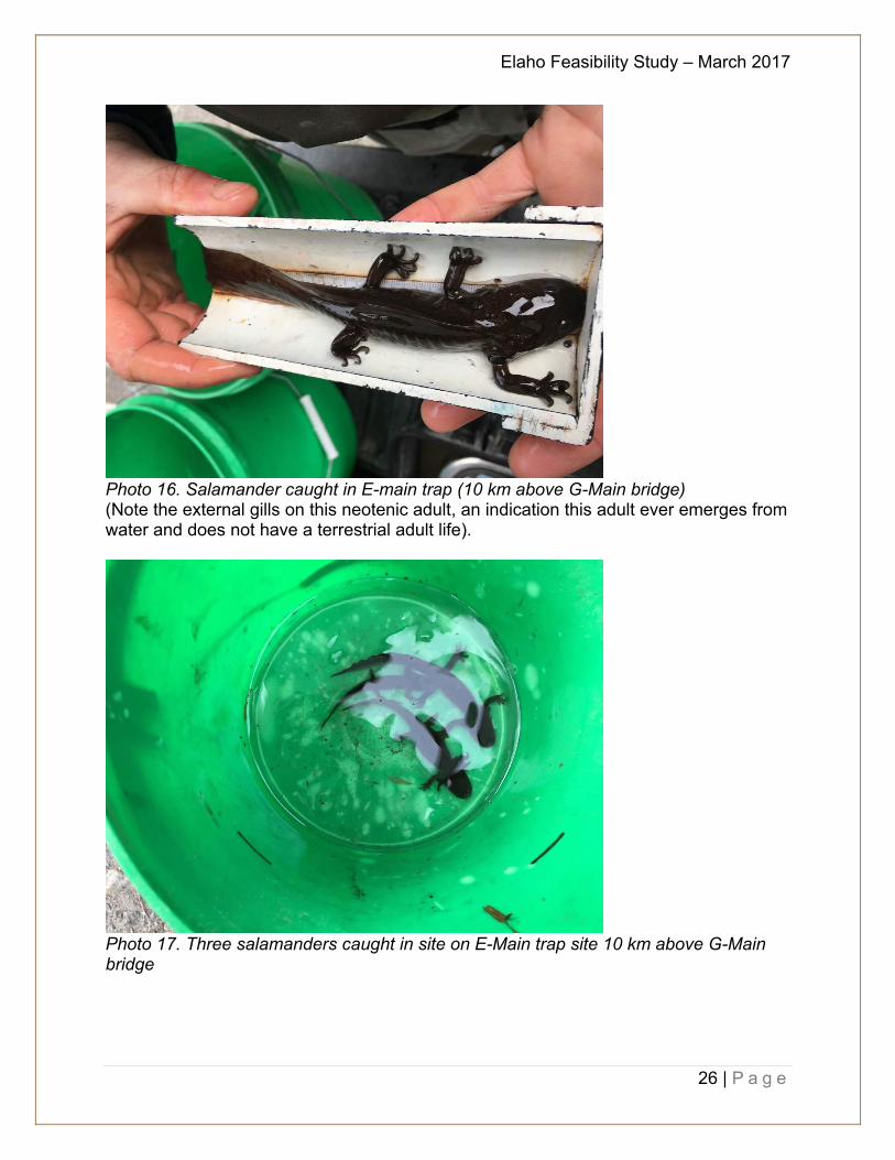
Photo 16. Salamander caught in E-main trap (10 km above G-Main bridge) (Note the external gills on this neotenic adult, an indication this adult ever emerges from water and does not have a terrestrial adult life).
Photo 17. Three salamanders caught in site on E-Main trap site 10 km above G-Main bridge
Elaho Feasibility Study – March 2017
27 | P a g e
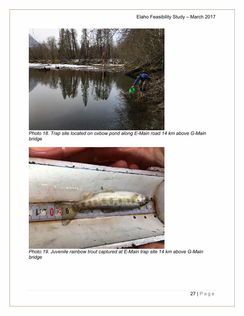
Photo 18. Trap site located on oxbow pond along E-Main road 14 km above G-Main bridge
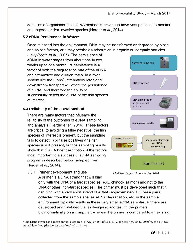
Photo 19. Juvenile rainbow trout captured at E-Main trap site 14 km above G-Main bridge

Elaho Feasibility Study – March 2017
28 | P a g e
5.0 eDNA Sampling
As part of the study to examine reintroducing anadromous salmonids into the upper Elaho River watershed the question regarding what species are present in the watershed remained an important one for consideration. It has been well established that rainbow trout were placed in the watershed by the provincial government. Anecdotal observations in recent years included first hand sightings of Chinook and coho salmon. However, it is difficult to sample the entire watershed to determine the extent of fish distribution. As was noted in Section 4.0, access to the upper watershed is extremely limited and many of the tributaries are inaccessible.
With modern technology, there is now an opportunity to “map” the watershed through eDNA, environmental DNA sampling, by collecting water samples from key locations. The addition of eDNA as part of this study is to establish a base-line against which comparisons can be made in future years once the obstruction has been altered to allow anadromous salmonid passage.
5.1 eDNA Sampling Explained:
Due to potential relative scarcity of salmonids in the Elaho River watershed (in part due to the presence of the obstruction), sampling for environmental DNA (eDNA) will help determine fish presence and species diversity both a) above and below the obstruction, and b) before and after the removal of the obstruction.
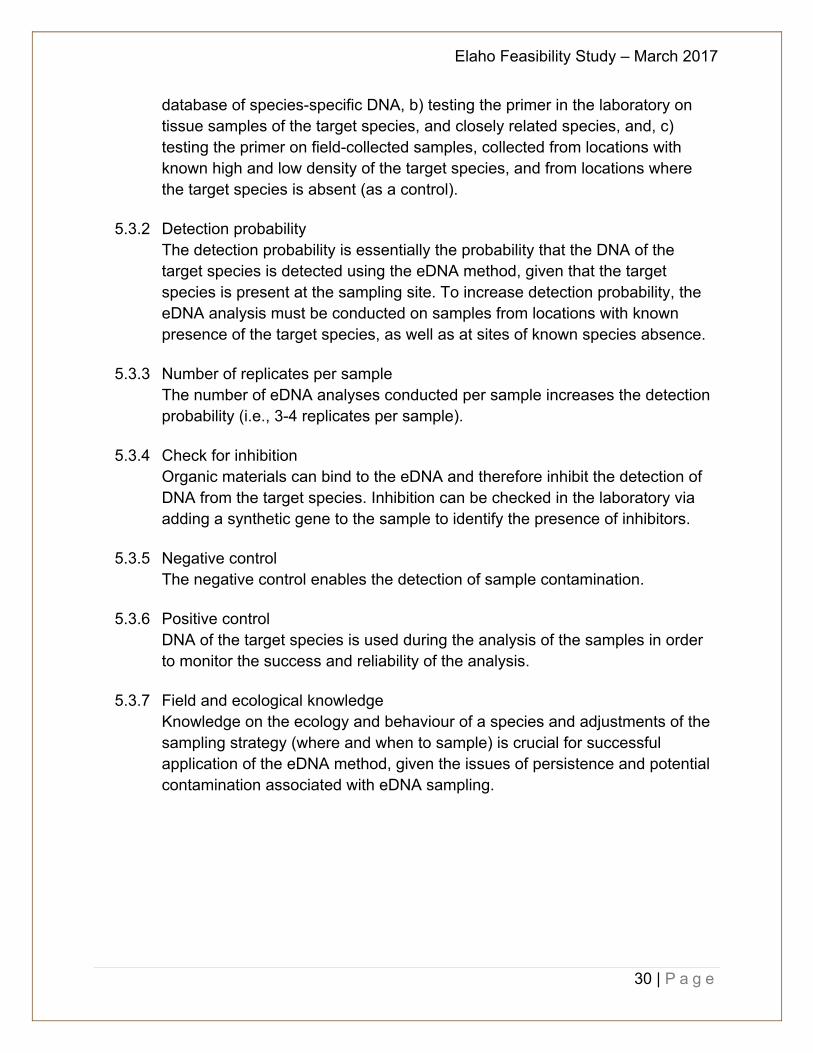
The eDNA method is a relatively new approach to monitor species distribution (Herder et al., 2014). With this method, DNA-based species-specific identification (also called “DNA barcoding”) is used in order to detect species through extracellular DNA or cellular debris present in environmental samples coming from cell lysis (decay) or living organism excretion of secretion (Valentini et al., 2009). The first application of the method was in 2008, wherein eDNA sampling in water was used to successfully detect the presence of the invasive American bullfrog (Lithobates catesbeianus). Researchers worldwide continue to develop and refine eDNA sampling and analysis methods in order to apply the technique to a broader range of species covering several taxa. In addition, research efforts have focussed on fundamental questions such as the persistence and dispersion of eDNA in various environmental media, detection probabilities, and the relationship between eDNA and
Photo credit: www.fishbio.com
Elaho Feasibility Study – March 2017
29 | P a g e
densities of organisms. The eDNA method is proving to have vast potential to monitor endangered and/or invasive species (Herder et al., 2014).
5.2 eDNA Persistence in Water:
Once released into the environment, DNA may be transformed or degraded by biotic and abiotic factors, or it may persist via adsorption in organic or inorganic particles (Levy-Booth et al., 2007). The persistence of eDNA in water ranges from about one to two weeks up to one month. Its persistence is a factor of both the degradation rate of the eDNA and streamflow and dilution rates. In a river system like the Elaho3, streamflow rates and downstream transport will affect the persistence of eDNA, and therefore the ability to successfully detect the eDNA of the fish species of interest.
5.3 Reliability of the eDNA Method:
There are many factors that influence the reliability of the outcomes of eDNA sampling and analysis (Herder et al., 2014). These factors are critical to avoiding a false negative (the fish species of interest is present, but the sampling fails to detect it) or false positives (the fish species is not present, but the sampling results show that it is). A brief description of the factors most important to a successful eDNA sampling program is described below (adapted from Herder et al., 2014):
5.3.1 Primer development and use A primer is a DNA strand that will bind only with the DNA of a target species (e.g., chinook salmon) and not to the DNA of other, non-target species. The primer must be developed such that it can bind with a very short strand of eDNA (approximately 150 base pairs) collected from the sample site, as eDNA degradation, etc. in the sample environment typically results in these very small eDNA samples. Primers are developed and validated via, a) designing and testing the primers bioinformatically on a computer, wherein the primer is compared to an existing
3 The Elaho River has a mean annual discharge (MAD) of 104 m3/s, a 10-year peak flow of 1,050 m3/s, and a 7-day annual low flow (the lowest baseflow) of 11.3 m3/s.
Modified diagram from Herder, 2014
Elaho Feasibility Study – March 2017
30 | P a g e
database of species-specific DNA, b) testing the primer in the laboratory on tissue samples of the target species, and closely related species, and, c) testing the primer on field-collected samples, collected from locations with known high and low density of the target species, and from locations where the target species is absent (as a control).
5.3.2 Detection probability
The detection probability is essentially the probability that the DNA of the target species is detected using the eDNA method, given that the target species is present at the sampling site. To increase detection probability, the eDNA analysis must be conducted on samples from locations with known presence of the target species, as well as at sites of known species absence.
5.3.3 Number of replicates per sample
The number of eDNA analyses conducted per sample increases the detection probability (i.e., 3-4 replicates per sample).
5.3.4 Check for inhibition
Organic materials can bind to the eDNA and therefore inhibit the detection of DNA from the target species. Inhibition can be checked in the laboratory via adding a synthetic gene to the sample to identify the presence of inhibitors.
5.3.5 Negative control
The negative control enables the detection of sample contamination.
5.3.6 Positive control DNA of the target species is used during the analysis of the samples in order to monitor the success and reliability of the analysis.
5.3.7 Field and ecological knowledge
Knowledge on the ecology and behaviour of a species and adjustments of the sampling strategy (where and when to sample) is crucial for successful application of the eDNA method, given the issues of persistence and potential contamination associated with eDNA sampling.
Elaho Feasibility Study – March 2017
31 | P a g e
5.4 Elaho eDNA sampling program:
The Elaho eDNA sampling program is designed to address all of the elements necessary to maximize the reliability of the eDNA method (Table 4). The objectives of the first year of the sampling program are to:
A. Develop and validate species-specific primers for chinook and coho salmon; and B. Determine fish species presence and diversity above and below the obstruction
prior to obstruction removal (e.g., establish a baseline while the obstruction is in place).
Table 4: Proposed 2017 eDNA sampling program for the Elaho River. Primer development and validation: targets = chinook and coho salmon
a) The first step (called in silico) has already been conducted at the University of Victoria lab.
b) The second step (called in vitro) will be done via the collection of fin clips from both the two target species (Chinook and coho) and various non-target species. Collection of the fin clips can be done through collaboration with Instream Fisheries Research, as they will be operating the rotary screw trap (RST) on the Cheakamus river this spring in order to monitor juvenile fish outmigration for BC Hydro. One fin clip from 10 juvenile Chinook and 10 juvenile coho will be collected and sent to the U.Vic. lab. One Fin clip from 5 juveniles of other species (e.g., chum, trout, etc.) will also be collected and sent to the lab. For species that are not likely present in the RST (e.g., resident trout and char), appropriate minnow trapping locations will be selected, such as above anadromous obstructions, to ensure that only resident life histories are targeted.
c) The third step (called in situ) will be conducted during the eDNA field sampling program, targeted for summer low flows. Water samples will be collected from sites known to have chinook and coho present, and the primers will be tested against these samples.
Detection probability
The field sampling program will specifically target sites where chinook and coho are known to be present, and where they are known to be absent (e.g., above anadromous obstructions, such the obstruction on the Mamquam located just above the Lower Mamquam hydroelectric power plant).
Number of samples and number of replicates per sample
This year’s budget allows for collection of 26 samples, dispersed both above and below the Elaho obstruction. eDNA analysis will be conducted on three replicates per sample.
Elaho Feasibility Study – March 2017
32 | P a g e
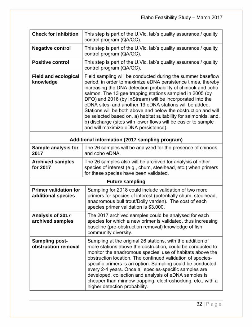
Check for inhibition This step is part of the U.Vic. lab’s quality assurance / quality control program (QA/QC).
Negative control This step is part of the U.Vic. lab’s quality assurance / quality control program (QA/QC).
Positive control This step is part of the U.Vic. lab’s quality assurance / quality control program (QA/QC).
Field and ecological knowledge
Field sampling will be conducted during the summer baseflow period, in order to maximize eDNA persistence times, thereby increasing the DNA detection probability of chinook and coho salmon. The 13 gee trapping stations sampled in 2005 (by DFO) and 2016 (by InStream) will be incorporated into the eDNA sites, and another 13 eDNA stations will be added. Stations will be both above and below the obstruction and will be selected based on, a) habitat suitability for salmonids, and, b) discharge (sites with lower flows will be easier to sample and will maximize eDNA persistence).
Additional information (2017 sampling program) Sample analysis for 2017
The 26 samples will be analyzed for the presence of chinook and coho eDNA.
Archived samples for 2017
The 26 samples also will be archived for analysis of other species of interest (e.g., chum, steelhead, etc.) when primers for these species have been validated.
Future sampling
Primer validation for additional species
Sampling for 2018 could include validation of two more primers for species of interest (potentially chum, steelhead, anadromous bull trout/Dolly varden). The cost of each species primer validation is $3,000.
Analysis of 2017 archived samples
The 2017 archived samples could be analysed for each species for which a new primer is validated, thus increasing baseline (pre-obstruction removal) knowledge of fish community diversity.
Sampling post-obstruction removal
Sampling at the original 26 stations, with the addition of more stations above the obstruction, could be conducted to monitor the anadromous species’ use of habitats above the obstruction location. The continued validation of species-specific primers is an option. Sampling could be conducted every 2-4 years. Once all species-specific samples are developed, collection and analysis of eDNA samples is cheaper than minnow trapping, electroshocking, etc., with a higher detection probability.
Elaho Feasibility Study – March 2017
33 | P a g e
Section II – Recommendation on Improvements for Fisheries Access 6.0 Restoration Prescriptions and Recommendations
As has been noted in previous studies, site visits, anecdotal accounts, and historical records, the Elaho River was an important anadromous watercourse, in particular for Chinook and coho salmon. While challenges to access the Upper Elaho through the lower box canyon may have always existed, access by anadromous fish into the upper watershed likely wasn’t hindered until the road construction in 1963 and the ensuing boulder obstructions that resulted from the road building. The immediate concern is how to address modifications to the existing rock obstructions and how to restore this section of stream to historic conditions in order to improve fish passage. Additional enhancement opportunities to the upper watershed have been identified in reports such as Reconnaissance Fish Presence and Habitat Inventory of the Upper Elaho River watershed (CERG, 2000) and may be worth exploring and updating once the main rock obstructions are addressed. As such, upper watershed restoration and enhancement options will not be discussed in this report. 6.1 Initial Site Survey and Monitoring
In order to determine the best course of action to improve anadromous salmonid access into the upper Elaho River watershed a detailed survey of the canyon and obstruction should be undertaken by a qualified engineering firm and river hydrologist. The study should include field evaluations during low flow (late summer) when the obstruction is most visible and the freshet has ended. As well, a detailed road survey is recommended to ensure any equipment operations will not compromise the road and result in further erosion or potential rock slides. As discussed in Section 4 and 5, monitoring of fish habitat, water quality, and eDNA should be completed prior to any works in order to establish base line levels. Consideration should be given to delaying obstruction alteration works until the 2018/2019 fiscal year in order to thoroughly study the site during late summer low-flow conditions and allow adequate time to access the site, upstream and downstream, collect relevant water quality and eDNA samples, and set Gee traps to identify fish presence and distribution. The results from the engineering and hydrology report along with the road survey should provide comprehensive information that will specify what activities should be undertaken to best improve fish passage. This could include rock blasting of the larger rock obstructions, installation
Elaho Feasibility Study – March 2017
34 | P a g e
of a fish ladder, realignment of rocks along the base of the cliff to improve water flow, or other options that have not yet been considered.
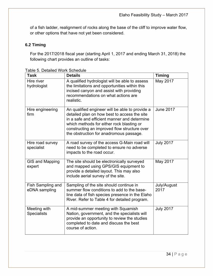
6.2 Timing
For the 2017/2018 fiscal year (starting April 1, 2017 and ending March 31, 2018) the following chart provides an outline of tasks:
Table 5. Detailed Work Schedule Task Details Timing Hire river hydrologist
A qualified hydrologist will be able to assess the limitations and opportunities within this incised canyon and assist with providing recommendations on what actions are realistic.
May 2017
Hire engineering firm
An qualified engineer will be able to provide a detailed plan on how best to access the site in a safe and efficient manner and determine which methods for either rock blasting or constructing an improved flow structure over the obstruction for anadromous passage.
June 2017
Hire road survey specialist
A road survey of the access G-Main road will need to be completed to ensure no adverse impacts to the road occur.
July 2017
GIS and Mapping expert
The site should be electronically surveyed and mapped using GPS/GIS equipment to provide a detailed layout. This may also include aerial survey of the site.
May 2017
Fish Sampling and eDNA sampling
Sampling of the site should continue in summer flow conditions to add to the base-line data of fish species presence in the Elaho River. Refer to Table 4 for detailed program.
July/August 2017
Meeting with Specialists
A mid-summer meeting with Squamish Nation, government, and the specialists will provide an opportunity to review the studies completed to date and discuss the best course of action.
July 2017
Elaho Feasibility Study – March 2017
35 | P a g e
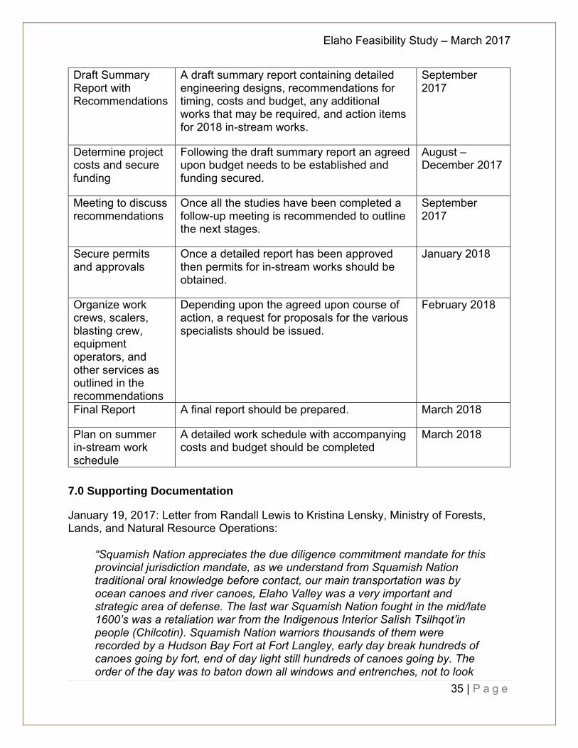
Draft Summary Report with Recommendations
A draft summary report containing detailed engineering designs, recommendations for timing, costs and budget, any additional works that may be required, and action items for 2018 in-stream works.
September 2017
Determine project costs and secure funding
Following the draft summary report an agreed upon budget needs to be established and funding secured.
August – December 2017
Meeting to discuss recommendations
Once all the studies have been completed a follow-up meeting is recommended to outline the next stages.
September 2017
Secure permits and approvals
Once a detailed report has been approved then permits for in-stream works should be obtained.
January 2018
Organize work crews, scalers, blasting crew, equipment operators, and other services as outlined in the recommendations
Depending upon the agreed upon course of action, a request for proposals for the various specialists should be issued.
February 2018
Final Report A final report should be prepared. March 2018
Plan on summer in-stream work schedule
A detailed work schedule with accompanying costs and budget should be completed
March 2018
7.0 Supporting Documentation
January 19, 2017: Letter from Randall Lewis to Kristina Lensky, Ministry of Forests, Lands, and Natural Resource Operations:
“Squamish Nation appreciates the due diligence commitment mandate for this provincial jurisdiction mandate, as we understand from Squamish Nation traditional oral knowledge before contact, our main transportation was by ocean canoes and river canoes, Elaho Valley was a very important and strategic area of defense. The last war Squamish Nation fought in the mid/late 1600’s was a retaliation war from the Indigenous Interior Salish Tsilhqot’in people (Chilcotin). Squamish Nation warriors thousands of them were recorded by a Hudson Bay Fort at Fort Langley, early day break hundreds of canoes going by fort, end of day light still hundreds of canoes going by. The order of the day was to baton down all windows and entrenches, not to look
Elaho Feasibility Study – March 2017
36 | P a g e
out at war canoes, as prevention measure, not to have warring tribe, on the war path to enter their fort.
The retaliation war, the Tsilhqot’in people went through Pemberton to the Lillooet River, to what Squamish Nation called back door of our respective territory, upper Elaho River watershed, this is why Squamish Nation has Wild Spirit Place in this area, trim data tile: 092J.052 & 092J.043. Squamish Nation tribes lived in this upper watershed to protect our interests, our warriors who died in battle were buried in areas of Wild Spirit Places. The Elaho valley was a very important area, that was sustainably supported by salmon, in our history, now cut off by a very large bolder from 1970’s logging road building. The first trade economy of the day, The Rush for the Spoils, was the fur trade, then the gold rush “Lie” to get European settler’s to come and settle in our area, it was told, a major gold strike on Squamish River watershed, many came, found iron pyrite, they thought they hit a big gold strike, to later find out it was “fool’s gold”, majority of gold seekers left in disappointment, some fool’s stayed.
Forestry extraction started in Vancouver, then Squamish, upper Squamish valleys. Squamish Nation has carbon dated artifacts in areas of historic villages to 1,200 years ago, and in Statmus IR 24, to 4,500 years ago. Squamish Nation Elders of our past, mentioned their deep concern of this major Elaho River blockage, that cut off the salmon runs to the upper watershed.
Chief Dick Williams, an Elder Squamish Nation member, who is on Squamish Nation Chief & Council, has strong memories of past historic Elder’s, telling him to reopen the river from the blockage. There are many miles of critical fishery habitat not being utilized by the fishery because of a forestry industry logging road building in the 1970’s, causing watershed fishery abundance decline for Squamish Nation, further no seasonal nutrient loading from spawning salmon and a major food source loss for grizzly, black bears, wolfs, eagles and plant flora fauna. BC Ministry of Forests (BCMOF) of the day, had a delegated fiduciary obligation to ensure no damage to rivers, that had salmon, as a result of forestry log road building, further, Department of Fisheries and Oceans also had a delegated fiduciary obligation to protect the river fishery from major impacts, such as, Elaho Valley River blockage of a very large bolder from logging road building.
Squamish Nation believes this is a major breach of a delegated fiduciary obligation to protect watershed salmon habitat from industry impact’s, a provincial and federal, Honour of the Crown is at risk.

Elaho Feasibility Study – March 2017
37 | P a g e
Squamish Nation presently has funding to remedy this impact, Squamish Nation is not asking the provincial jurisdiction for any funding, only the support from the provincial jurisdiction to assist in remediation/restoration and rehabilitation of the Elaho River Watershed.
The provincial jurisdiction “extensive history” is limited in the context of Squamish Nation history, when a major watershed is impacted by industry, then it’s extensive history aboriginal impact. Provincial staff, present and past do not know the traditional inherent historic knowledge of Squamish Nation. Squamish Nation looks forward to working with FLNR on this important river restoration initiative. Thank you Ta’haxwtn Randall W Lewis Squamish Nation”

Elaho Feasibility Study – March 2017
38 | P a g e
March 28, 2007: Tree Farm Licence 38 Harvest Announcement:
Elaho Feasibility Study – March 2017
39 | P a g e
December 6, 2007: Squamish Salmon Recovery Plan Technical Review Committee
(TRC) response to BC Conservation Foundation application regarding proposal to investigate steelhead life history in the Upper Squamish River and Elaho River. Recommendations by TRC to revise proposal to include exploration of Elaho River obstruction and to provide specific recommendations and strategies for improvements for access. (Note, revisions never received).

Elaho Feasibility Study – March 2017
40 | P a g e
8.0 References and Bibliography
Beamish, R.J., Z. Zhang. “Biology of ocean age 0 Hatchery, Wild Ocean, and Wild Stream Type Chinook in the Strait of Georgia”. North Pacific Anadromous Fish Commission. October 1995.
Best, J., S. et al. “B.C. Tree Farm Licence 38 Forestry / First Nations Perspective” Conservation 481. Fall 2006
Brooks, G.R. “The Fluvial Reworking of Late Pleistocene Drift, Squamish River, British Columbia”. Geographie physique et Quaternaire, vol. 48, no 1, 1994, p. 51-68.
Cascade Environmental Resource Group Limited (CERG). “Reconnaissance Fish Presence and Habitat Inventory of the Upper Elaho River Watershed”. Prepared for Squamish River Watershed Society and Ministry of Environment. October 2000.
Department of Fisheries and Oceans Canada. Unclassified Memorandum. August 4, 2005.
Hancock, M.J., D.E. Marshall. “Catalogue and Spawning Escapements of Statistical Area 28 Howe Sound Burrard Inlet. Canadian Data Report of Fisheries and Aquatic Sciences No. 557. January 1986
Healey, M.C. “Life History of Chinook Salmon”. Department of Fisheries and Oceans Canada, Pacific Biological Station. UBC Press. 1991.
Herder, J., A. et al. “Environmental DNA: a review of the possible applications for detection of (invasive) species”. Stiching RAVON, Nikmegen. Report 2013-2014. 111 pp. 2014.
Hora, Z.D., K.D. Hancock. “Some New Dimension Stone Properties in British Columbia” British Columbia Geologcial Survey Geological Fieldwork. 1994.
Levy, D.A., S. Davies. “Squamish River Watershed Status Report”. Squamish River Watershed Fisheries Sustainability Forum. November 1997.
Levy-Booth, D.J., et al. Cycling of extracellular DNA in the soil environment. Soil Biol. Biochem. 39: 2977-2991. 2007.
Lewis, R. Personal communication. 2016. Squamish Nation, Squamish Office. MacKinlay, D., K. Howard. Fish Health Management Plan for all Major Salmonid
Enhancement Facilities. June 2004. Minister of Agriculture and Lands. “Agreement on Land Use Planning Between the
Squamish First Nation and the Province of British Columbia”. June 2007. Ministry of Environment. “Sea to Sky Land and Resource Management Plan”. April
2008. Nahanee, Chrystal. Personal communication. 2017. Squamish Nation. Nelson Environmental Services. “Stream and Lake Classification: Lower Squamish,
Lower Elaho, and Tributaries”. Prepared for Interfor. December 1997.
Elaho Feasibility Study – March 2017
41 | P a g e
Nuszdorfer, F. “Old and Large Douglas-Fir and Western Red Cedar in the Squamish Forest District”. Prepared by BC Forest Service for Squamish Forest District. April 2000.
Pacific Salmon Foundation. “Squamish River Watershed Salmon Recovery Plan”. Prepared by Golder Associates. May 2005.
Parish, R. “Tree Book: Learning to Recognize Trees of BC”. Canadian Forest Service. 1994.
Pedersen, L. “Tree Farm Licence 38 Rationale for Allowable Annual Cut”. Ministry of Forests. August 1998.
Province of British Columbia. “Clendinning Provincial Park – Purpose Statement and Zoning Plan”. March 2003.
Raven River Habitat Services. “Fisheries Assessment of Selected Tributaries of the Lower Squamish, Ashlu and Elaho Rivers” Prepared for International Forest Products Empire Logging Division. January 1998.
Region 2 Provincial Fishing Regulations; www.env.gov.bc.ca/fw/fish. Reimer, R. “The Mountains and Rocks are Forever: Lithics and Landscapes of
Skwxwu7mesh Uxwumixw”. Submitted to the School of McMaster University Graduate Studies in Partial Fulfilment of Doctor of Philosophy. December 2011.
Reimer, R. “Squamish Traditional Use Study: Squamish Traditional Use of Nch’kay or the Mount Garibaldi and Brohm Ridge Area”. April 2003.
Rochetta, S. Personal Communication. Ministry of Forests, Land and Natural Resource Operations, Squamish Office. 2016
Schubert, N.D. “Enumeration of the 1988 – 1992 Squamish River Chinook Salmon Escapement”. Canadian Manuscript Report of Fisheries and Aquatic Sciences No. 2187. November 1993.
Squamish Forest District. “1993 Soo Timber Supply Area Forest Management Plan”. Province of BC. December 1, 1993.
Squamish Nation Land and Resources Committee. “Xay Temíxw Land Use Plan” May 2001.
Squamish River Watershed Society. “Squamish River Watershed Strategic Plan – Meeting #2”. October 2001
Squamish River Watershed Society. “Howe Sound Gathering Proceedings – June 6, 2009”. June 2009.
Squamish River Watershed Society. “Squamish Strategic Salmon Recovery Plan Workshop – November 17, 2009”. November 2009.
Squamish River Watershed Society. “Strategic Salmon Recovery Plan Technical Review Committee. Meeting Minutes”. January 2011.
Squamish River Watershed Society. Strategic Salmon Recovery Plan Technical Review Committee Meeting Minutes. Feb 2012.
Elaho Feasibility Study – March 2017
42 | P a g e
Tallman, D.C. “2007 Creel Survey of the Squamish River Watershed Recreational Fishery”. Prepared by J.O. Thomas and Associates for Squamish River Watershed Society. April 2008.
Triton Environmental Consultants Limited. “Reconnaissance Level Stream and Lake Inventory for Sims Creek Watershed”. Prepared for Interfor and MOE. February 1998.
Tso, K., M. Stein and Y. Barney. A First Nations Forestry Perspective in Tree Farm 38”. Cons 481. University of British Columbia. Faculty of Forestry. October 2006.
Valentini, A., F. Pompanon, and P. Taberlet. 2009. DNA barcoding for ecologists. Trends. Ecol. Evol. 24: 110-117.
van Dishoeck, P. “Squamish River System Juvenile Steelhead Sampling Program, Squamish, Cheakamus, Mamquam, and Elaho Rivers, and Shovelnose Creek – October 1999”. Prepared for Ministry of Environment. ARL report no. 337-2. 2000
Van Will, P. R. Brahniuk & G. Pestal. “Certification Unit Profile: Inner South Coast Pink Salmon – Excluding Fraser River – 2009”. Canadian Manuscript Report of Fisheries and Aquatic Sciences 2877. 2009.
Zaldokas, D.O., P. Slaney, D.J.A. Duff. “Salmonid Smolt Yield from a Small Nursery Tributary of a Large Coastal River in Response to Restorative Treatments. Watershed Restoration Projects Report No. 7. 2001.
Elaho Feasibility Study – March 2017
43 | P a g e
Appendix I Forestry and Logging in the Elaho Watershed Canadian Colliers acquired logging rights to harvest timber in the Elaho valley in 1961 as part of TFL 38. In 1963 Weldwood of Canada Ltd. took over the operations and extended the logging road to the mouth of the Elaho River (Hancock, 1986). Empire Logging, a division of Weldwood, continued harvesting trees in TFL 38 for the next three decades. In 1995 International Forest Products purchased the rights to log TFL 38 from Weldwood of Canada and in 2005, when Interfor pulled out from Squamish, the Squamish Nation took over management of the TFL purchasing the 900,000 ha tree fam licence for a reported $6.5 million. Local forestry consultants, CRB Logging, were hired by Squamish Nation to help manage the newly formed Northwest Squamish Logging, a company held in trust with the Squamish Nation. Elaho Logging Ltd was retained at the time to ensure no loss of jobs (files from Squamish Chief, May 2006). With the sale of TFL 38 to Squamish Nation came a reduction in the allowable annual cut (AAC) (previously 250,500 m3/year) to a new level of 109,453 m3/year which was in line with the recommended decrease in long-term AAC levels as stated in the “BC Ministry of Forest’s Incremental Silviculture Strategy of 2001” (Best 2006).
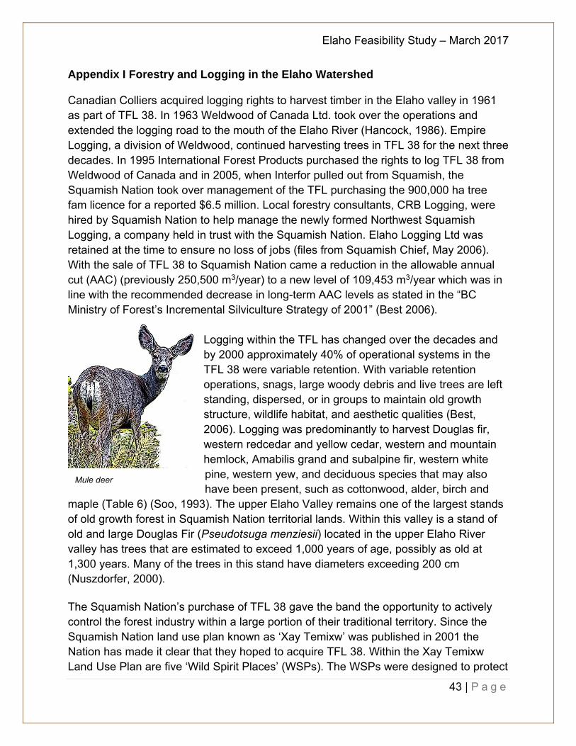
Logging within the TFL has changed over the decades and by 2000 approximately 40% of operational systems in the TFL 38 were variable retention. With variable retention operations, snags, large woody debris and live trees are left standing, dispersed, or in groups to maintain old growth structure, wildlife habitat, and aesthetic qualities (Best, 2006). Logging was predominantly to harvest Douglas fir, western redcedar and yellow cedar, western and mountain hemlock, Amabilis grand and subalpine fir, western white pine, western yew, and deciduous species that may also have been present, such as cottonwood, alder, birch and
maple (Table 6) (Soo, 1993). The upper Elaho Valley remains one of the largest stands of old growth forest in Squamish Nation territorial lands. Within this valley is a stand of old and large Douglas Fir (Pseudotsuga menziesii) located in the upper Elaho River valley has trees that are estimated to exceed 1,000 years of age, possibly as old at 1,300 years. Many of the trees in this stand have diameters exceeding 200 cm (Nuszdorfer, 2000). The Squamish Nation’s purchase of TFL 38 gave the band the opportunity to actively control the forest industry within a large portion of their traditional territory. Since the Squamish Nation land use plan known as ‘Xay Temixw’ was published in 2001 the Nation has made it clear that they hoped to acquire TFL 38. Within the Xay Temixw Land Use Plan are five ‘Wild Spirit Places’ (WSPs). The WSPs were designed to protect
Mule deer
Elaho Feasibility Study – March 2017
44 | P a g e
land that is highly valued by the Squamish Nation for spiritual and cultural reasons. Three of these WSPs are within TFL 38 and represent a large portion of the TFL. Nsiiyx–nitem tl’s sutich (upper Elaho Valley) is 17,753 ha and lies adjacent to the east side of Clendinning Provincial Park. Nexw–ayantsut (Sims Creek) is 17,280 ha in size and lies south west and partially adjacent to Clendinning Provincial Park. Este– tiwilh is 9,173 ha and lies to the west of the Squamish River just south of the convalescence of the Elaho and Squamish Rivers. One of the main priorities of the Squamish Nation is to preserve these areas and keep them free of any commercial and/or industrial development. Since the Upper Elaho Valley also represents a significant portion of the total harvestable land base within TFL 38 (17,753 ha total, of which approximately 40% is harvestable), historically there was a constant string of clashes between the forestry companies and First Nations and environmentalists. In 1996, the adjacent Clendinning watershed was removed from the TFL area to form Clendinning Provincial Park, due to interests in watershed and wilderness preservation. This further reduced the amount of timber available for harvesting, leading to uncertainties in the viability of forestry employment and operations in and around Squamish (Best, 2006). Table 6. Some Major Tree Species in the Elaho River watershed (Parish, 1994) Common Name Latin Name Amabilis fir Abies amabilis Black cottonwood Populas balssmifera Black hawthorn Crataegus douglasii Douglas fir Pseudotsuga menziesii Douglas maple Acer glabrum Grand fir Abies grandis Lodgepole pine Pinus latifolia Mountain hemlock Tsuga mertensiana Paper birch Betula payrifera Subalpine fir Abies lasiocarpa Western hemlock Tsuga heterophylla Western redcedar Thuja plicata Western white pine Pinus monticala Western yew Taxus brevifolia Yellow cedar Chamaecyparis nootkatensis

Elaho Feasibility Study – March 2017
45 | P a g e
Appendix II Geology of the Elaho Valley
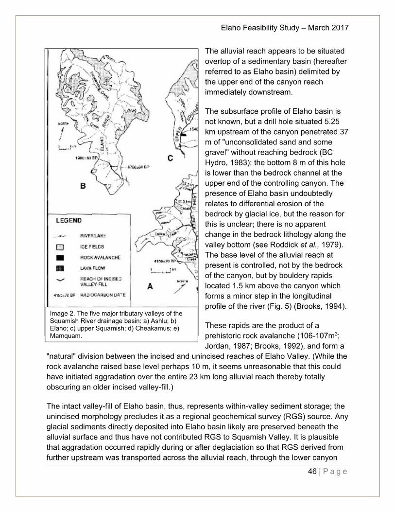
The Elaho watershed was last covered by glacier ice during the late Pleistocene Fraser Glaciation, which began over 30,000 years ago and ended around 11,000 years ago (Clague, 1981). The system is located near the Plio-Pleistocene stratovolcano Mount Cayley also called t'aḵ'taḵmu'yin tl'a in7in'a'xe7en, the Landing Place of the Thunderbird (Reimer, 2003), which would have contributed volcanic and pyroclastic deposits that may be present in the sediments to day The Elaho Valley is 1,250 km2 in area and joins Squamish Valley 52 km upstream of Squamish estuary (Image 1 below). The Elaho River is 65 km long from its headwaters at Elaho Glacier to the Elaho-Squamish confluence (Image 2b). The river flows within bedrock canyons over its upper 24 km and lower 8 km; the intermediate reach is alluvial, being initially braided for 11 km then meandering for the remaining 12 km. Along the alluvial reach, the Elaho River has a gravel bed with sand commonly occurring on the surface of the river bars and in the flood plain deposits. Sims and Clendinning Creeks flow are major tributaries; both have large ice fields in their headwaters (Image 2b) (Brooks, 1994).
Incised valley-fill deposits occur only along the bedrock canyon of the lower 8 km of Elaho Valley (Image 2b). Upstream, the river flows over intact valley-fill deposits along the alluvial reach. There is no evidence of remnant valley-fills within Sims and Clendinning valleys and along the upper canyon reach of Elaho River. Over the 23 km long alluvial reach above the lower canyon, the morphology of the valley bottom generally consists of flood plain deposits extending from one side of the valley to the other. Unincised alluvial fans originating from the major alpine creeks are splayed partially across the valley bottom. The existence of this intact valley-fill relates to the bedrock morphology of Elaho Valley.
Image 1. Squamish River drainage basin south-western BC
Elaho Feasibility Study – March 2017
46 | P a g e
The alluvial reach appears to be situated overtop of a sedimentary basin (hereafter referred to as Elaho basin) delimited by the upper end of the canyon reach immediately downstream. The subsurface profile of Elaho basin is not known, but a drill hole situated 5.25 km upstream of the canyon penetrated 37 m of "unconsolidated sand and some gravel" without reaching bedrock (BC Hydro, 1983); the bottom 8 m of this hole is lower than the bedrock channel at the upper end of the controlling canyon. The presence of Elaho basin undoubtedly relates to differential erosion of the bedrock by glacial ice, but the reason for this is unclear; there is no apparent change in the bedrock lithology along the valley bottom (see Roddick et al., 1979). The base level of the alluvial reach at present is controlled, not by the bedrock of the canyon, but by bouldery rapids located 1.5 km above the canyon which forms a minor step in the longitudinal profile of the river (Fig. 5) (Brooks, 1994). These rapids are the product of a prehistoric rock avalanche (106-107m3; Jordan, 1987; Brooks, 1992), and form a
"natural" division between the incised and unincised reaches of Elaho Valley. (While the rock avalanche raised base level perhaps 10 m, it seems unreasonable that this could have initiated aggradation over the entire 23 km long alluvial reach thereby totally obscuring an older incised valley-fill.) The intact valley-fill of Elaho basin, thus, represents within-valley sediment storage; the unincised morphology precludes it as a regional geochemical survey (RGS) source. Any glacial sediments directly deposited into Elaho basin likely are preserved beneath the alluvial surface and thus have not contributed RGS to Squamish Valley. It is plausible that aggradation occurred rapidly during or after deglaciation so that RGS derived from further upstream was transported across the alluvial reach, through the lower canyon
Image 2. The five major tributary valleys of the Squamish River drainage basin: a) Ashlu; b) Elaho; c) upper Squamish; d) Cheakamus; e) Mamquam.
Elaho Feasibility Study – March 2017
47 | P a g e
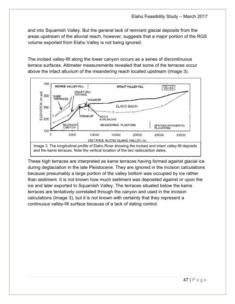
and into Squamish Valley. But the general lack of remnant glacial deposits from the areas upstream of the alluvial reach, however, suggests that a major portion of the RGS volume exported from Elaho Valley is not being ignored. The incised valley-fill along the lower canyon occurs as a series of discontinuous terrace surfaces. Altimeter measurements revealed that some of the terraces occur above the intact alluvium of the meandering reach located upstream (Image 3).
These high terraces are interpreted as kame terraces having formed against glacial ice during deglaciation in the late Pleistocene. They are ignored in the incision calculations because presumably a large portion of the valley bottom was occupied by ice rather than sediment. It is not known how much sediment was deposited against or upon the ice and later exported to Squamish Valley. The terraces situated below the kame terraces are tentatively correlated through the canyon and used in the incision calculations (Image 3), but it is not known with certainty that they represent a continuous valley-fill surface because of a lack of dating control.
Image 3. The longitudinal profile of Elaho River showing the incised and intact valley-fill deposits and the kame terraces. Note the vertical location of the two radiocarbon dates.

Elaho Feasibility Study – March 2017
48 | P a g e
Appendix III Hydrometric Data Flow data obtained from the provincial Ministry of Environment weather office has been summarized to provide information on how much volume of water the Elaho River contributes to the Squamish watershed:
Figure 4. Mean daily river flow (1955 to 1990) (Taken from Levy, 1997)

Elaho Feasibility Study – March 2017
49 | P a g e
Appendix IV Mining in the Elaho Watershed4 Location: Lat 50.110833; Long -123.416667; Map 92J/3 Vancouver Mining Division (approximately 60 km north of Squamish) Access: From Squamish by logging road upstream along Squamish River Owners: Quarry Pacific Industries Ltd. Operator: Quarry Pacific Industries Ltd. Commodities: Dimension stone – granite ID Number 3150, Ministry of Energy, Mines, and Petroleum Resources Local Geology: The Elaho River quarry opened in a quartz diorite phase of the Coastal Plutonic Complex. The stone is fine to medium grained with parallel texture well defined by orientation of mica flakes. The rock is exposed in steep cliffs and along the banks of the Elaho River, some 7.5 km upstream from its confluence with the Squamish River. The fracture spacing, several metres apart, allows removal of large blocks from the quarry face with minimum of waste. The only observed inhomogenities in the quarry area are two light coloured fine-grained aplitic dikes 10 to 20 cm thick. The square-shaped blocks are processed into granite tile in Surrey, BC and marketed under the trade name of Whistler White granite. Appendix V Recreation Over the years, with the new road access, the Elaho Valley became increasingly visited by people in pursuit of recreational activities, including fishing, hunting, kayaking, hiking, and environmental conservation. In the 1990s, as part of the Sea to Sky Land and Resource Management Plan, protected spaces were established in the Elaho Watershed with direction from Squamish Nation to protect Wild Spirit Places, old-growth stands of timber, including Douglas Firs over 1,000 years old, and sensitive habitats and conservation lands. Over 84,789 hectares of lands have been set aside for protection, wild spirit places, and conservancy lands.
4 Excerpt from Hora, 1994
Roosevelt elk
Elaho Feasibility Study – March 2017
50 | P a g e
Appendix VI Fish species in the Elaho River
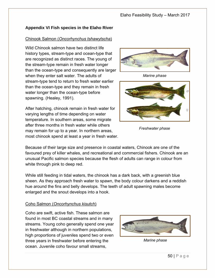
Chinook Salmon (Oncorhynchus tshawytscha)
Wild Chinook salmon have two distinct life history types, stream-type and ocean-type that are recognized as distinct races. The young of the stream-type remain in fresh water longer than the ocean-type and consequently are larger when they enter salt water. The adults of stream-type tend to return to fresh water earlier than the ocean-type and they remain in fresh water longer than the ocean-type before spawning. (Healey, 1991). After hatching, chinook remain in fresh water for varying lengths of time depending on water temperature. In southern areas, some migrate after three months in fresh water while others may remain for up to a year. In northern areas, most chinook spend at least a year in fresh water. Because of their large size and presence in coastal waters, Chinook are one of the favoured prey of killer whales, and recreational and commercial fishers. Chinook are an unusual Pacific salmon species because the flesh of adults can range in colour from white through pink to deep red. While still feeding in tidal waters, the chinook has a dark back, with a greenish blue sheen. As they approach fresh water to spawn, the body colour darkens and a reddish hue around the fins and belly develops. The teeth of adult spawning males become enlarged and the snout develops into a hook.
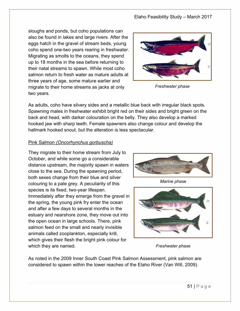
Coho Salmon (Oncorhynchus kisutch)
Coho are swift, active fish. These salmon are found in most BC coastal streams and in many streams. Young coho generally spend one year in freshwater although in northern populations, high proportions of juveniles spend two or even three years in freshwater before entering the ocean. Juvenile coho favour small streams,
Freshwater phase
Marine phase
Marine phase
Elaho Feasibility Study – March 2017
51 | P a g e
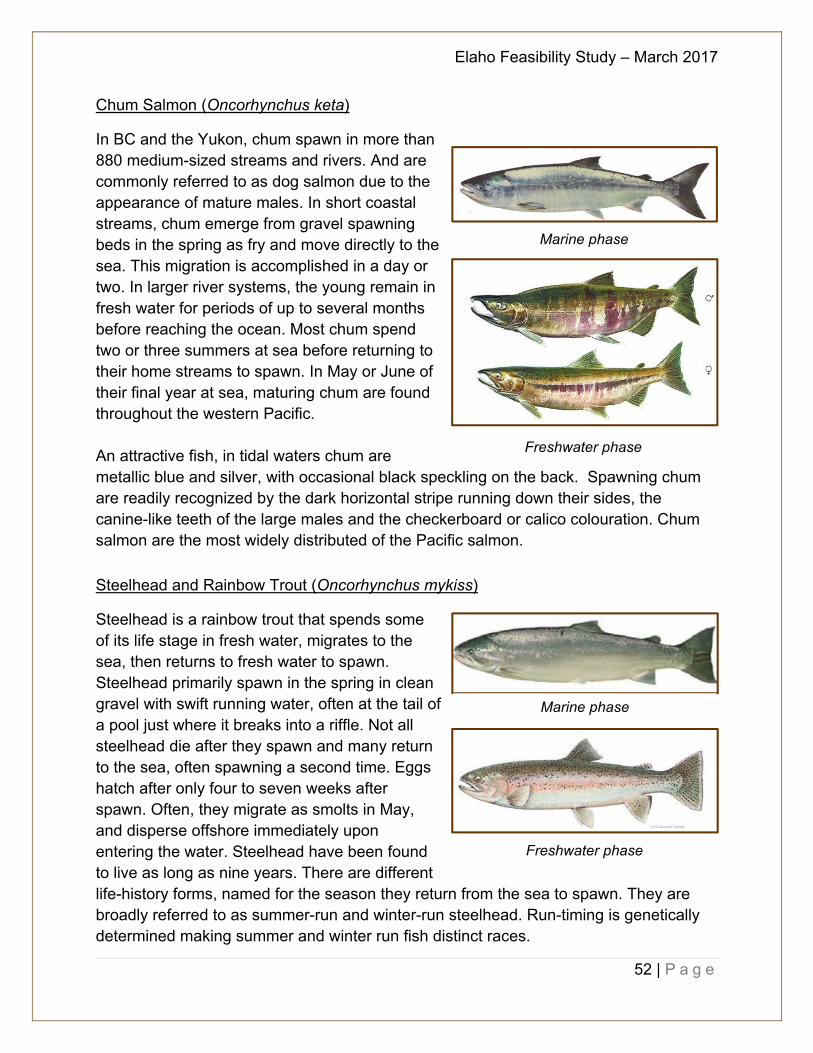
sloughs and ponds, but coho populations can also be found in lakes and large rivers. After the eggs hatch in the gravel of stream beds, young coho spend one-two years rearing in freshwater. Migrating as smolts to the oceans, they spend up to 18 months in the sea before returning to their natal streams to spawn. While most coho salmon return to fresh water as mature adults at three years of age, some mature earlier and migrate to their home streams as jacks at only two years. As adults, coho have silvery sides and a metallic blue back with irregular black spots. Spawning males in freshwater exhibit bright red on their sides and bright green on the back and head, with darker colouration on the belly. They also develop a marked hooked jaw with sharp teeth. Female spawners also change colour and develop the hallmark hooked snout, but the alteration is less spectacular. Pink Salmon (Oncorhynchus gorbuscha)
They migrate to their home stream from July to October, and while some go a considerable distance upstream, the majority spawn in waters close to the sea. During the spawning period, both sexes change from their blue and silver colouring to a pale grey. A peculiarity of this species is its fixed, two-year lifespan. Immediately after they emerge from the gravel in the spring, the young pink fry enter the ocean and after a few days to several months in the estuary and nearshore zone, they move out into the open ocean in large schools. There, pink salmon feed on the small and nearly invisible animals called zooplankton, especially krill, which gives their flesh the bright pink colour for which they are named. As noted in the 2009 Inner South Coast Pink Salmon Assessment, pink salmon are considered to spawn within the lower reaches of the Elaho River (Van Will, 2009).
Freshwater phase
Freshwater phase
Marine phase
Elaho Feasibility Study – March 2017
52 | P a g e
Chum Salmon (Oncorhynchus keta)
In BC and the Yukon, chum spawn in more than 880 medium-sized streams and rivers. And are commonly referred to as dog salmon due to the appearance of mature males. In short coastal streams, chum emerge from gravel spawning beds in the spring as fry and move directly to the sea. This migration is accomplished in a day or two. In larger river systems, the young remain in fresh water for periods of up to several months before reaching the ocean. Most chum spend two or three summers at sea before returning to their home streams to spawn. In May or June of their final year at sea, maturing chum are found throughout the western Pacific. An attractive fish, in tidal waters chum are metallic blue and silver, with occasional black speckling on the back. Spawning chum are readily recognized by the dark horizontal stripe running down their sides, the canine-like teeth of the large males and the checkerboard or calico colouration. Chum salmon are the most widely distributed of the Pacific salmon.
Steelhead and Rainbow Trout (Oncorhynchus mykiss)
Steelhead is a rainbow trout that spends some of its life stage in fresh water, migrates to the sea, then returns to fresh water to spawn. Steelhead primarily spawn in the spring in clean gravel with swift running water, often at the tail of a pool just where it breaks into a riffle. Not all steelhead die after they spawn and many return to the sea, often spawning a second time. Eggs hatch after only four to seven weeks after spawn. Often, they migrate as smolts in May, and disperse offshore immediately upon entering the water. Steelhead have been found to live as long as nine years. There are different life-history forms, named for the season they return from the sea to spawn. They are broadly referred to as summer-run and winter-run steelhead. Run-timing is genetically determined making summer and winter run fish distinct races.
Marine phase
Freshwater phase
Marine phase
Freshwater phase
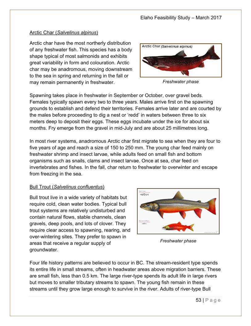
Elaho Feasibility Study – March 2017
53 | P a g e
Arctic Char (Salvelinus alpinus)
Arctic char have the most northerly distribution of any freshwater fish. This species has a body shape typical of most salmonids and exhibits great variability in form and colouration. Arctic char may be anadromous, moving downstream to the sea in spring and returning in the fall or may remain permanently in freshwater. Spawning takes place in freshwater in September or October, over gravel beds. Females typically spawn every two to three years. Males arrive first on the spawning grounds to establish and defend their territories. Females arrive later and are courted by the males before proceeding to dig a nest or ‘redd’ in waters between three to six meters deep to deposit their eggs. These eggs incubate under the ice for about six months. Fry emerge from the gravel in mid-July and are about 25 millimetres long. In most river systems, anadromous Arctic char first migrate to sea when they are four to five years of age and reach a size of 150 to 250 mm. The young char feed mainly on freshwater shrimp and insect larvae, while adults feed on small fish and bottom organisms such as snails, clams and insect larvae. Once at sea, char feed on invertebrates and fishes. In the fall, char return to freshwater to overwinter and escape from freezing in the sea. Bull Trout (Salvelinus confluentus)
Bull trout live in a wide variety of habitats but require cold, clean water bodies. Typical bull trout systems are relatively undisturbed and contain natural flows, stable channels, clean gravels, deep pools, and lots of clover. They require clear access to spawning, rearing, and over-wintering sites. They prefer to spawn in areas that receive a regular supply of groundwater. Four life history patterns are believed to occur in BC. The stream-resident type spends its entire life in small streams, often in headwater areas above migration barriers. These are small fish, less than 0.5 km. The large river-type spends its adult life in large rivers but moves to smaller tributary streams to spawn. The young fish remain in these streams until they grow large enough to survive in the river. Adults of river-type Bull
Freshwater phase
Freshwater phase
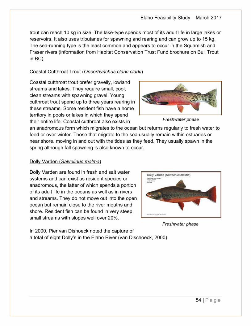
Elaho Feasibility Study – March 2017
54 | P a g e
trout can reach 10 kg in size. The lake-type spends most of its adult life in large lakes or reservoirs. It also uses tributaries for spawning and rearing and can grow up to 15 kg. The sea-running type is the least common and appears to occur in the Squamish and Fraser rivers (information from Habitat Conservation Trust Fund brochure on Bull Trout in BC).
Coastal Cutthroat Trout (Oncorhynchus clarki clarki)
Coastal cutthroat trout prefer gravelly, lowland streams and lakes. They require small, cool, clean streams with spawning gravel. Young cutthroat trout spend up to three years rearing in these streams. Some resident fish have a home territory in pools or lakes in which they spend their entire life. Coastal cutthroat also exists in an anadromous form which migrates to the ocean but returns regularly to fresh water to feed or over-winter. Those that migrate to the sea usually remain within estuaries or near shore, moving in and out with the tides as they feed. They usually spawn in the spring although fall spawning is also known to occur.
Dolly Varden (Salvelinus malma)
Dolly Varden are found in fresh and salt water systems and can exist as resident species or anadromous, the latter of which spends a portion of its adult life in the oceans as well as in rivers and streams. They do not move out into the open ocean but remain close to the river mouths and shore. Resident fish can be found in very steep, small streams with slopes well over 20%. In 2000, Pier van Dishoeck noted the capture of a total of eight Dolly’s in the Elaho River (van Dischoeck, 2000).
Freshwater phase
Freshwater phase
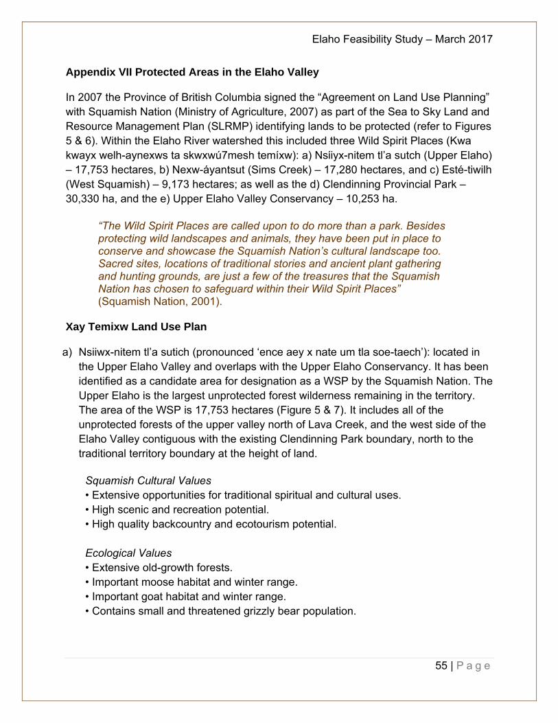
Elaho Feasibility Study – March 2017
55 | P a g e
Appendix VII Protected Areas in the Elaho Valley In 2007 the Province of British Columbia signed the “Agreement on Land Use Planning” with Squamish Nation (Ministry of Agriculture, 2007) as part of the Sea to Sky Land and Resource Management Plan (SLRMP) identifying lands to be protected (refer to Figures 5 & 6). Within the Elaho River watershed this included three Wild Spirit Places (Kwa kwayx welh-aynexws ta skwxwú7mesh temíxw): a) Nsίiyx-nitem tl’a sutch (Upper Elaho) – 17,753 hectares, b) Nexw-áyantsut (Sims Creek) – 17,280 hectares, and c) Esté-tiwilh (West Squamish) – 9,173 hectares; as well as the d) Clendinning Provincial Park – 30,330 ha, and the e) Upper Elaho Valley Conservancy – 10,253 ha.
“The Wild Spirit Places are called upon to do more than a park. Besides protecting wild landscapes and animals, they have been put in place to conserve and showcase the Squamish Nation’s cultural landscape too. Sacred sites, locations of traditional stories and ancient plant gathering and hunting grounds, are just a few of the treasures that the Squamish Nation has chosen to safeguard within their Wild Spirit Places” (Squamish Nation, 2001).
Xay Temixw Land Use Plan
a) Nsiiwx-nitem tl’a sutich (pronounced ‘ence aey x nate um tla soe-taech’): located in the Upper Elaho Valley and overlaps with the Upper Elaho Conservancy. It has been identified as a candidate area for designation as a WSP by the Squamish Nation. The Upper Elaho is the largest unprotected forest wilderness remaining in the territory. The area of the WSP is 17,753 hectares (Figure 5 & 7). It includes all of the unprotected forests of the upper valley north of Lava Creek, and the west side of the Elaho Valley contiguous with the existing Clendinning Park boundary, north to the traditional territory boundary at the height of land.
Squamish Cultural Values • Extensive opportunities for traditional spiritual and cultural uses. • High scenic and recreation potential. • High quality backcountry and ecotourism potential. Ecological Values • Extensive old-growth forests. • Important moose habitat and winter range. • Important goat habitat and winter range. • Contains small and threatened grizzly bear population.
Elaho Feasibility Study – March 2017
56 | P a g e
b) Nexw-áyantsut (pronounced ‘nook eye un sote’): located at Sims Creek. This area has been identified as a candidate area for designation as a WSP by the Squamish Nation. The Sims Creek WSP is 17,280 hectares in size and is adjacent to Clendenning Provincial Park. The lower portions of the valley have recently been logged (since 1995); however, important old growth forest and riparian habitat remains intact in the mid and upper portions of the valley. The area offers outstanding backcountry recreation and tourism potential, including a cross-over hike from the Sims Creek Valley to the popular Princess Louisa Inlet. The trail is currently threatened with logging. Sims Creek has been the focus of the “Witness Project,” a collaboration between the Squamish Nation and non-native individuals and groups concerned about forest and cultural issues in the northern portion of the territory.
Squamish Cultural Values • Extensive opportunities for traditional spiritual and cultural uses. • High scenic and recreation potential. • High quality backcountry and ecotourism potential.
Ecological Values • Extensive old-growth forests. • Important goat habitat and winter range. • Contains small and threatened grizzly bear population.
c) Esté-tiwilh (pronounced ‘us tut ee wayth’): located on the west side of the Squamish
River between the Ashlu River and the Lower Elaho River. It has been identified as a candidate area for designation as a WSP by the Squamish Nation. Over 16 kilometres of low elevation old-growth and riparian forests remain intact, with very high quality grizzly bear and mountain goat habitat, as well high quality anadromous salmonid habitat. The WSP also includes a portion of the lower Ashlu, which includes an historic village site, as well as Sigurd Creek, abutting Mt. Tantalus Provincial Park. The Esté-tiwilh WSP is 9,173 hectares in size.
Squamish Cultural Values • Extensive opportunities for traditional spiritual and cultural uses. • High scenic and recreation potential. • High quality backcountry and ecotourism potential.
Ecological Values • Extensive old-growth forest and intact riparian habitat • High capability grizzly bear habitat. • Extensive intact and productive salmon habitat. • Important mountain goat winter range.
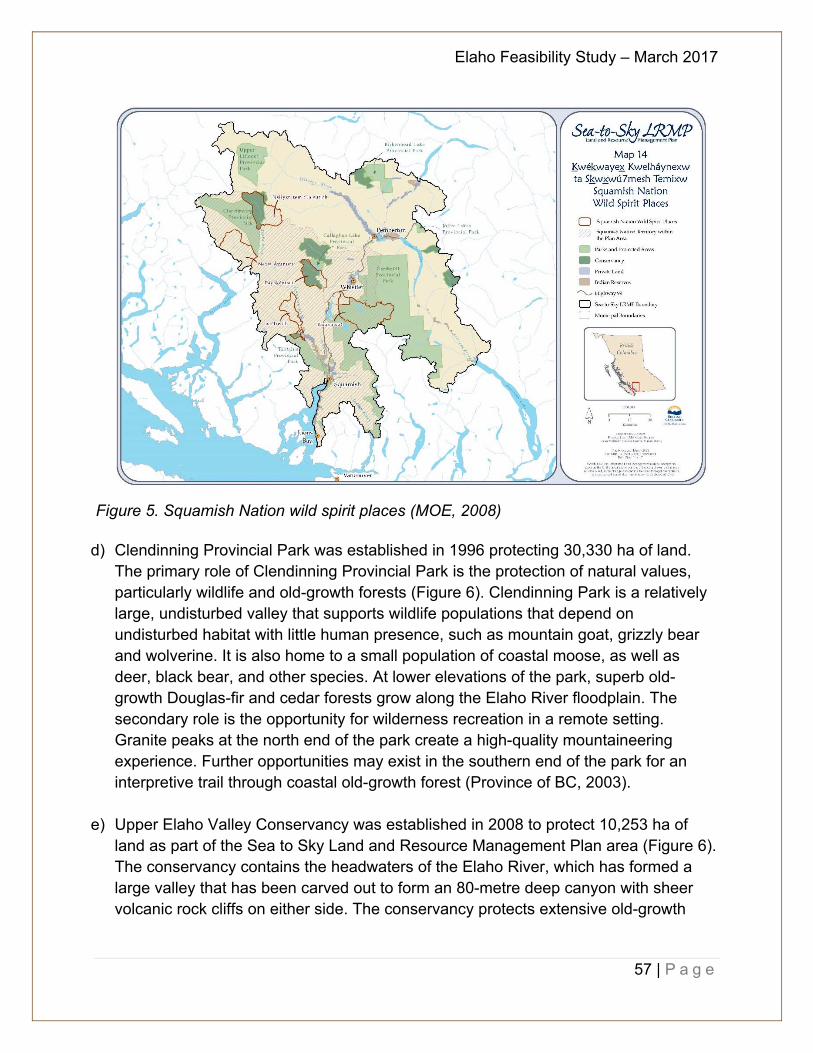
Elaho Feasibility Study – March 2017
57 | P a g e
Figure 5. Squamish Nation wild spirit places (MOE, 2008)
d) Clendinning Provincial Park was established in 1996 protecting 30,330 ha of land. The primary role of Clendinning Provincial Park is the protection of natural values, particularly wildlife and old-growth forests (Figure 6). Clendinning Park is a relatively large, undisturbed valley that supports wildlife populations that depend on undisturbed habitat with little human presence, such as mountain goat, grizzly bear and wolverine. It is also home to a small population of coastal moose, as well as deer, black bear, and other species. At lower elevations of the park, superb old-growth Douglas-fir and cedar forests grow along the Elaho River floodplain. The secondary role is the opportunity for wilderness recreation in a remote setting. Granite peaks at the north end of the park create a high-quality mountaineering experience. Further opportunities may exist in the southern end of the park for an interpretive trail through coastal old-growth forest (Province of BC, 2003).
e) Upper Elaho Valley Conservancy was established in 2008 to protect 10,253 ha of land as part of the Sea to Sky Land and Resource Management Plan area (Figure 6). The conservancy contains the headwaters of the Elaho River, which has formed a large valley that has been carved out to form an 80-metre deep canyon with sheer volcanic rock cliffs on either side. The conservancy protects extensive old-growth
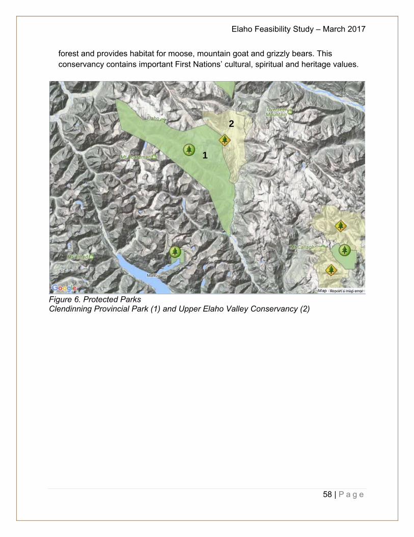
Elaho Feasibility Study – March 2017
58 | P a g e
forest and provides habitat for moose, mountain goat and grizzly bears. This conservancy contains important First Nations’ cultural, spiritual and heritage values.
Figure 6. Protected Parks Clendinning Provincial Park (1) and Upper Elaho Valley Conservancy (2)
1
2
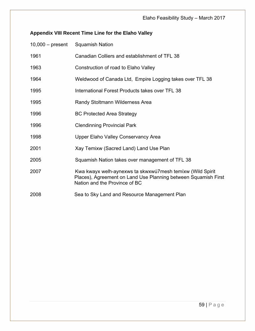
Elaho Feasibility Study – March 2017
59 | P a g e
Appendix VIII Recent Time Line for the Elaho Valley 10,000 – present Squamish Nation
1961 Canadian Colliers and establishment of TFL 38
1963 Construction of road to Elaho Valley
1964 Weldwood of Canada Ltd, Empire Logging takes over TFL 38
1995 International Forest Products takes over TFL 38
1995 Randy Stoltmann Wilderness Area
1996 BC Protected Area Strategy
1996 Clendinning Provincial Park
1998 Upper Elaho Valley Conservancy Area
2001 Xay Temixw (Sacred Land) Land Use Plan
2005 Squamish Nation takes over management of TFL 38
2007 Kwa kwayx welh-aynexws ta skwxwú7mesh temíxw (Wild Spirit Places), Agreement on Land Use Planning between Squamish First Nation and the Province of BC
2008 Sea to Sky Land and Resource Management Plan
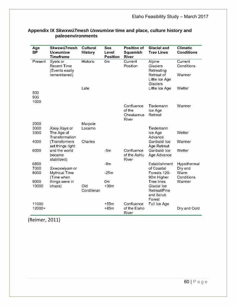
Elaho Feasibility Study – March 2017
60 | P a g e
Appendix IX Skwxwú7mesh Uxwumixw time and place, culture history and paleoenvironments
(Reimer, 2011)

Elaho Feasibility Study – March 2017
61 | P a g e
Appendix X Additional Site Maps
Figure 7. Squamish Nation Wild Spirit Places and Sensitive Areas (MOE, 2008)
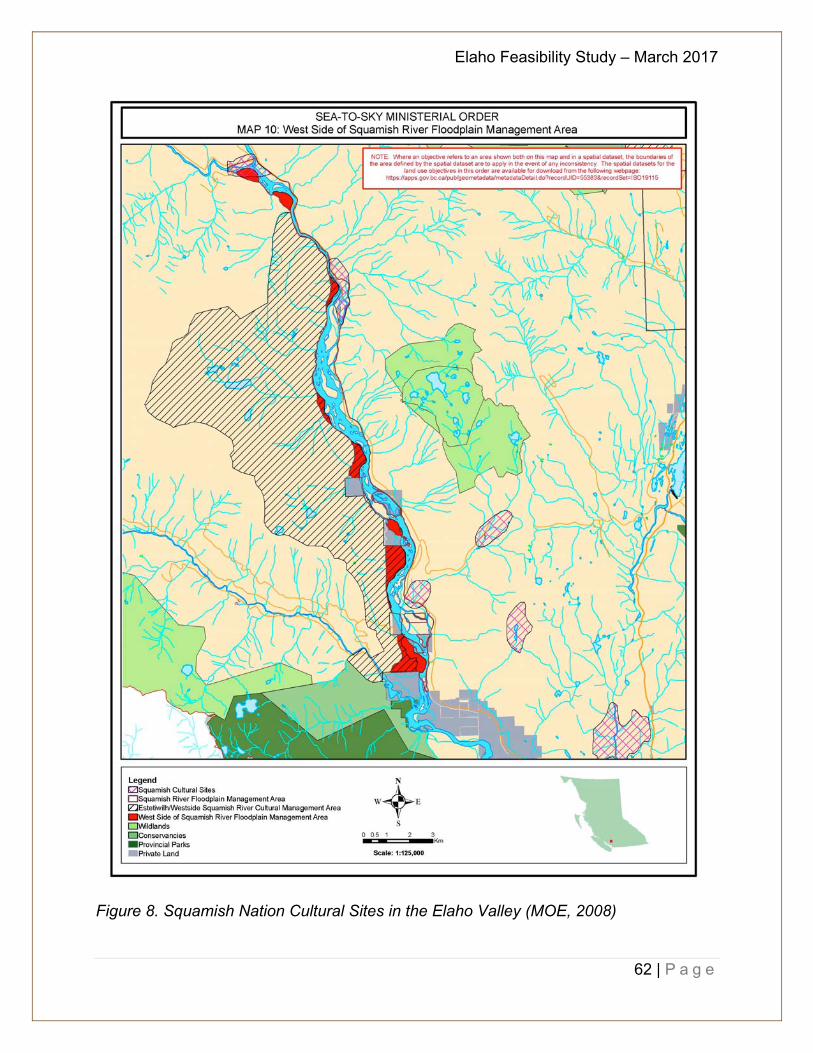
Elaho Feasibility Study – March 2017
62 | P a g e
Figure 8. Squamish Nation Cultural Sites in the Elaho Valley (MOE, 2008)
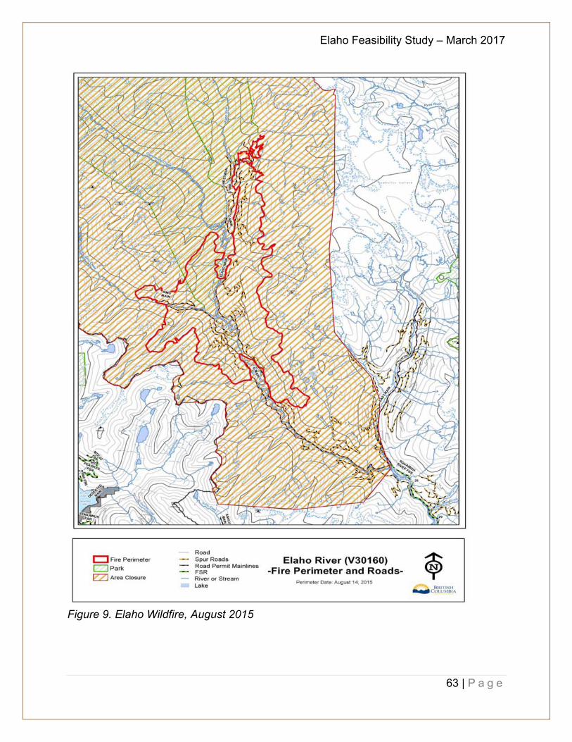
Elaho Feasibility Study – March 2017
63 | P a g e
Figure 9. Elaho Wildfire, August 2015
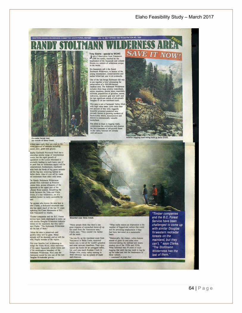
Elaho Feasibility Study – March 2017
64 | P a g e
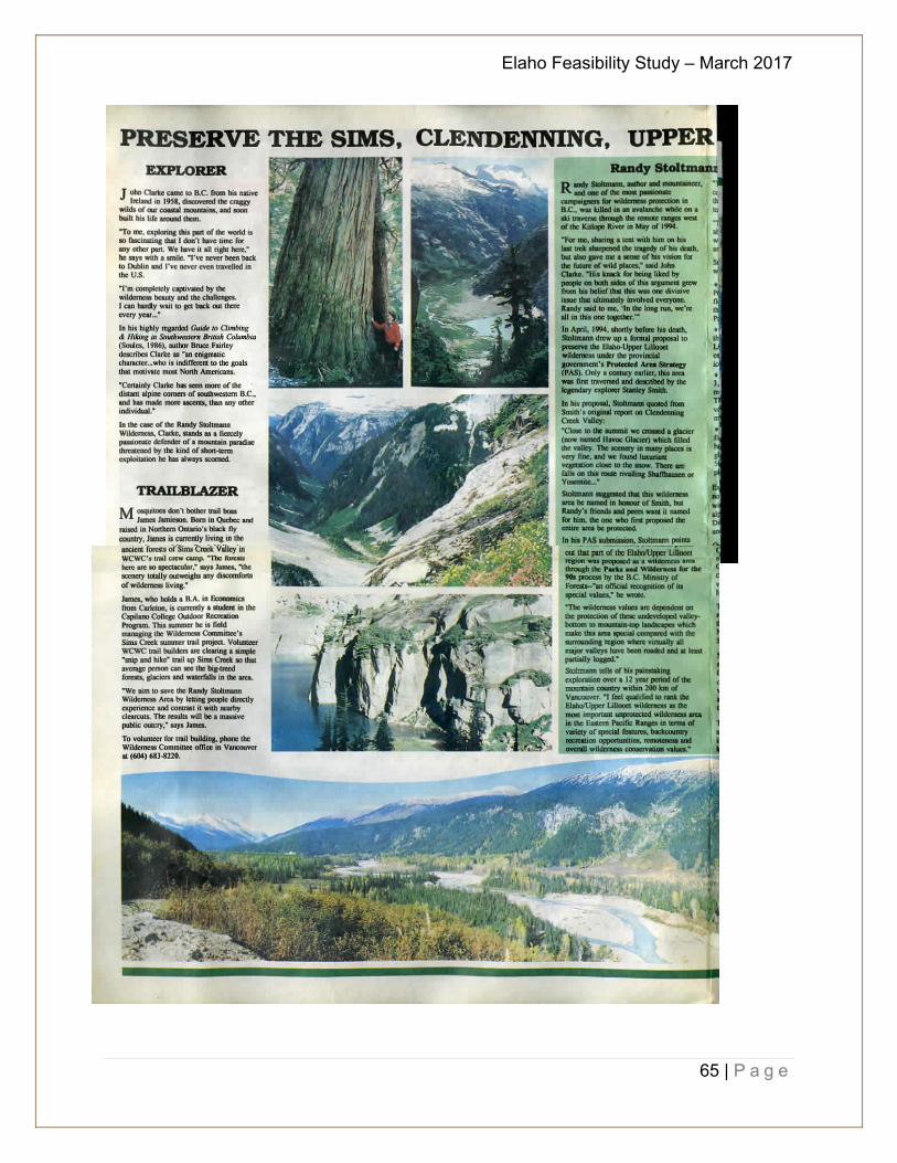
Elaho Feasibility Study – March 2017
65 | P a g e
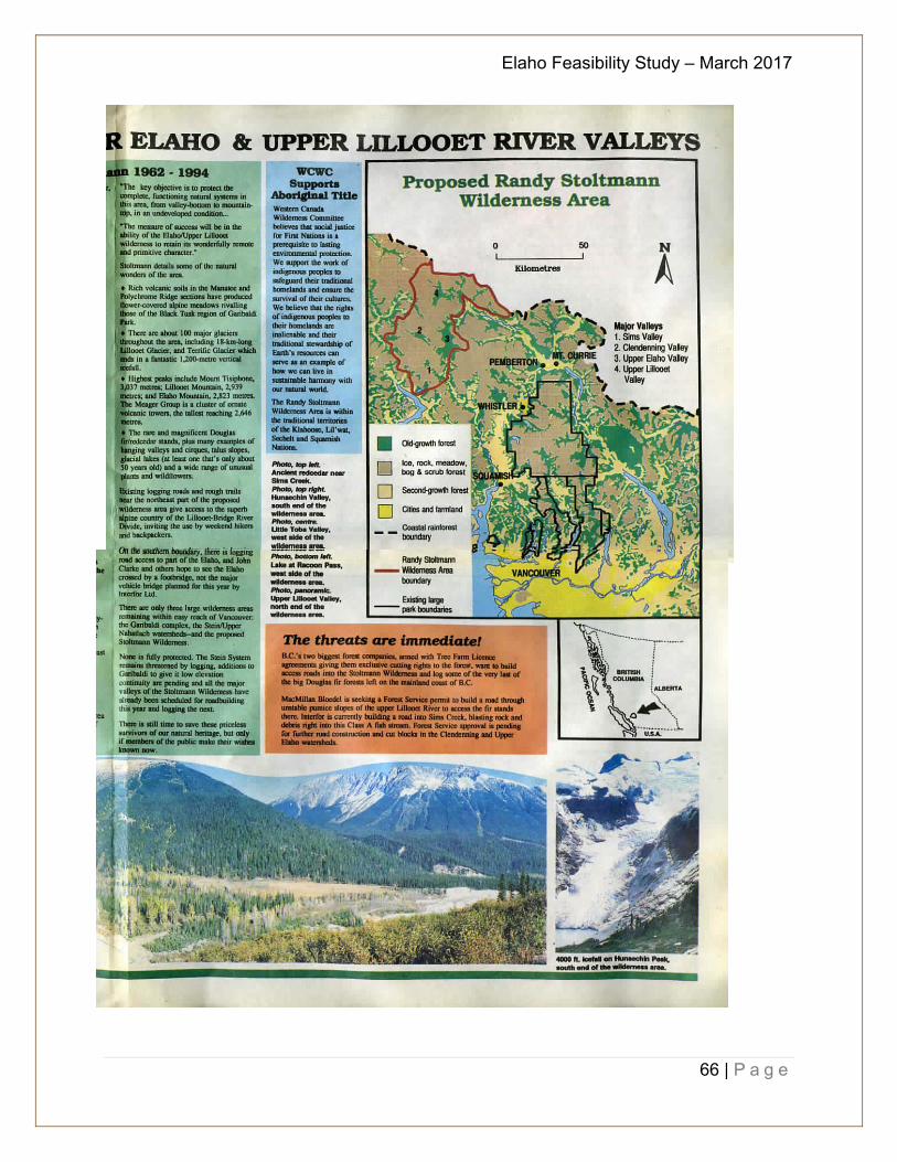
Elaho Feasibility Study – March 2017
66 | P a g e
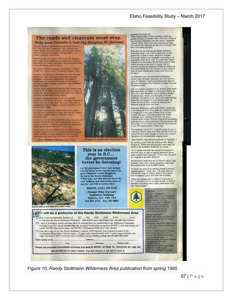
Elaho Feasibility Study – March 2017
67 | P a g e
Figure 10. Randy Stoltmann Wilderness Area publication from spring 1995

Elaho Feasibility Study – March 2017
68 | P a g e