Embed Size (px)
Citation preview

OC
ÉA
NO
PA
CÍF
ICO
P E R Ú
C O L O M B I A
0ºQUITO
Guayaquil
0 50 100 km
E L T O R N E A D O P R O J E C T
07
Surface area: 17,878 ha
Phase: Advanced Exploration
Classification:Greenfield
Molybdenum
Copper
Type of Deposit:Copper - molybdenum porphyry and probable VMS - type deposit
Type of investment:
Strategic Alliance
POTENCIAL
LOCATIONProvince: BolívarCanton: San Miguel,Chimbo and CalumaParish District: Balsapamba, Caluma, Magdalena, Bilován, Julio Moreno, Asunción and Telimbela.
CuMo
LOCAL GEOLOGY
PROJECT HISTORY
REGIONAL GEOLOGY
ENVIRONMENT
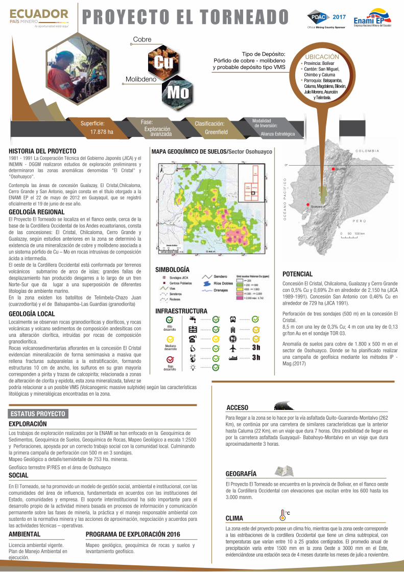
In El Torneado, a social, environmental, and institutional management model has been promoted with the communities in the area of influence, based on agreements made with the government, communities, and the company. Interinstitutional support has been important in developing mining activities based on continuous information and communication processes regarding mining phases, practices, and environmental management, all based on mining laws and actions involving approach, negotiation, and agreements to perform technical and operational activities.
SOCIAL
PROJECT STATUS
Exploration work performed by ENAMI has focused on Sediment Geochemistry, Soil Geochem-istry, Rock Geochemistry, Geological Mapping at a 1:25,000 scale, and Drillholes, all alongside property social work with the local community. The first drilling campaign is nearly complete, with 500 m in three drill holes.Detailed/semi-detailed Geological Mapping of 753 mining hectares. IP/RES land geophysics in the Osohuayco area.
EXPLORATION
2016 EXPLORATION PROGRAMGeological mapping, rock and soil geochemistry, and geophysical survey.
The El Torneado Project is located on the western flank, near the base of the Western Cordillera of the Ecuadorian Andes, with the following concessions: El Cristal, Chilcaloma, Cerro Grande and Gualazay. According to previous studies made in the zone, a copper and molybdenum mineralization was found, associated with the Cu - Mo porphyry system in intrusive rocks, with acidic to intermediate composition. The western flank of the Western Cordillera is made up of volcanic submarine ground from an arc of islands. Large displacement faults have produced wrenches along the North-South train, giving way to superposition of different marine environment lithologies. The zone contains Telimbela-Chazo Juan (quartz diorite) and Balsapamba-Las Guardias (granodiorite) batholiths.
ACCESSThis zone is accessed through the Quito-Guaranda-Montalvo paved road (262 km), followed by a similar highway that arrives as far as Caluma (22 km); it takes 7 hours to arrive from Quito. To arrive from Guayaquil, you can take a the paved highway Guayaquil-Babahoyo-Montalvo; this trip takes approximately 3 hours.
GEOGRAPHYThe El Torneado Project is located in Bolivar Province, on the western flank of the Western Cordillera, with elevations of between 600 and 3,000 masl.
CLIMATEC
The eastern project area has a cool climate, while the western area is located in foothills of the Western Cordillera, and has a subtropical climate, with temperatures between 10º and 25º C. Annual precipitation varies between 1500 mm in the western part of the zone and 3000 mm in the eastern part, with a four month dry season running from July to November.
1981 - 1991 Japanese Government Technical Cooperation (JICA) andINEMIN - DGGM made preliminary exploration studies finding the "El Cristal" and "Osohuayco" anomalous zones.This includes the concession areas known as Gualazay, El Cristal, Chilcaloma, Cerro Grande, and San Antonio, as stated in the title granted toENAMI EP on May 22, 2012 in Guayaquil, and was officially registered on June 19 of that year.
POTENTIALEl Cristal, Chilcaloma, Gualazay, and Cerro Grande Concessionswith 0.5% Cu and 0.69% Zn in around 2,150 ha (JICA 1989-1991). San Antonio Concession with 0.46% Cu in around 729 ha (JICA 1991).Three drillholes (500 m) in the El Cristal concession.8.5 m with a grade of 0.3% Cu; 4 m with a grade of 0.13 gr/ton Au in the TOR 03 drillhole.Copper soil anomaly 1,800 x 500 m in the Osohuayco sector. Here, a larger geophysical campaign has been planned using the IP - Mag. methods.
Granodiorite and diorite rocks are observed locally, along with volcanic rocks and volcanic sediments with andesite composition and chloritic alterations, with intrusion of rocks with a granodiorite composition. Volcano-sedimentary rocks outcropping in the El Cristal concession show semi-massive to massive mineralization, which fills in fractures located sub-parallel to the stratification, forming structures 10 m wide, with sulphides that mostly contain pyrite and traces of chalcopyrite; this mineralized zone, which is related to the chlorite and epidote alternation zones, may be related to a possible VMS (Volcanogenic massive sulphide), according to the lithological and mineralogical characteristics found in the zone.
Environmental license in force.Environmental Management Plan underway.
07
SYMBOLOGY
INFRASTRUCTURE
GEOQUEMICAL MAP OF ROCKS/ El Cristal Sector
High development
Medium development
Low development
........
........
........
........
........
........
........
........
........
........
........
3 h3 h
Populated areas
Soundings
Drill hole trace
Roads
Path
Double rivers
Drains
Rock sampling –Cu ppmValue
9872.22
OC
ÉA
NO
PA
CÍF
ICO
P E R Ú
C O L O M B I A
0ºQUITO
Guayaquil
0 50 100 km
P R O Y E C T O E L T O R N E A D O
07
Superficie: 17.878 ha
Fase: Exploración avanzada
Clasificación:Greenfield
Molibdeno
Cobre
Tipo de Depósito:Pórfido de cobre - molibdenoy probable depósito tipo VMS
Modalidad de Inversión:
Alianza Estratégica
POTENCIAL
UBICACIÓNProvincia: BolívarCantón: San Miguel,Chimbo y CalumaParroquia: Balsapamba,Caluma, Magdalena, Bilován,Julio Moreno, Asunción y Telimbela.
CuMo
GEOLOGÍA LOCAL
SIMBOLOGÍA
INFRAESTRUCTURA
HISTORIA DEL PROYECTO
GEOLOGÍA REGIONAL
AMBIENTAL
En El Torneado, se ha promovido un modelo de gestión social, ambiental e institucional, con las comunidades del área de influencia, fundamentada en acuerdos con las instituciones del Estado, comunidades y empresa. El soporte interinstitucional ha sido importante para el desarrollo propio de la actividad minera basada en procesos de información y comunicación permanente sobre las fases de minería, la práctica y el manejo responsable ambiental con sustento en la normativa minera y las acciones de aproximación, negociación y acuerdos para las actividades técnicas – operativas.
SOCIAL
ESTATUS PROYECTO
Los trabajos de exploración realizados por la ENAMI se han enfocado en la Geoquímica de Sedimentos, Geoquímica de Suelos, Geoquímica de Rocas, Mapeo Geológico a escala 1:2500 y Perforaciones, apoyada por un correcto trabajo social con la comunidad local. Culminando la primera campaña de perforación con 500 m en 3 sondajes.Mapeo Geológico a detalle/semidetalle de 753 Ha. mineras.
Geofísico terrestre IP/RES en el área de Osohuayco
EXPLORACIÓN
PROGRAMA DE EXPLORACIÓN 2016Mapeo geológico, geoquímica de rocas y suelos y levantamiento geofísico.
El Proyecto El Torneado se localiza en el flanco oeste, cerca de la base de la Cordillera Occidental de los Andes ecuatorianos, consta de las concesiones: El Cristal, Chilcaloma, Cerro Grande y Gualazay, según estudios anteriores en la zona se determinó la existencia de una mineralización de cobre y molibdeno asociada a un sistema pórfido de Cu – Mo en rocas intrusivas de composición ácida a intermedia. El oeste de la Cordillera Occidental está conformada por terrenos volcánicos submarino de arco de islas; grandes fallas de desplazamiento han producido desgarres a lo largo de un tren Norte-Sur que da lugar a una superposición de diferentes litologías de ambiente marino. En la zona existen los batolitos de Telimbela-Chazo Juan (cuarzodiorita) y el de Balsapamba-Las Guardias (granodiorita)
MAPA GEOQUÍMICO DE SUELOS/Sector Osohuayco
ACCESOPara llegar a la zona se lo hace por la vía asfaltada Quito-Guaranda-Montalvo (262 Km), se continúa por una carretera de similares características que la anterior hasta Caluma (22 Km), en un viaje que dura 7 horas. Otra posibilidad de llegar es por la carretera asfaltada Guayaquil- Babahoyo-Montalvo en un viaje que dura aproximadamente 3 horas.
GEOGRAFÍAEl Proyecto El Torneado se encuentra en la provincia de Bolívar, en el flanco oeste de la Cordillera Occidental con elevaciones que oscilan entre los 600 hasta los 3.000 msnm.
CLIMAC
La zona este del proyecto posee un clima frio, mientras que la zona oeste corresponde a las estribaciones de la cordillera Occidental que tiene un clima subtropical, con temperaturas que varían entre 10 a 25 grados centígrados. El promedio anual de precipitación varía entre 1500 mm en la zona Oeste a 3000 mm en el Este, evidenciándose una estación seca de 4 meses durante los meses de julio a noviembre.
1981 - 1991 La Cooperación Técnica del Gobierno Japonés (JICA) y el INEMIN - DGGM realizaron estudios de exploración preliminares y determinaron las zonas anomálicas denomidas "El Cristal" y "Osohuayco".
Contempla las áreas de concesión Gualazay, El Cristal,Chilcaloma, Cerro Grande y San Antonio, según consta en el título otorgado a la ENAMI EP el 22 de mayo de 2012 en Guayaquil, que se registró oficialmente el 19 de junio de ese año.
POTENCIAL
Altodesarrollo
Medianodesarrollo
desarrolloBajo ........
........
........
........
........
........
........
........
........
........
........
3 h3 h
Concesión El Cristal, Chilcaloma, Gualazay y Cerro Grande con 0,5% Cu y 0,69% Zn en alrededor de 2.150 ha (JICA 1989-1991). Concesión San Antonio con 0,46% Cu en alrededor de 729 ha (JICA 1991).
Perforación de tres sondajes (500 m) en la concesión El Cristal. 8,5 m con una ley de 0,3% Cu; 4 m con una ley de 0,13 gr/ton Au en el sondaje TOR 03.
Anomalía de suelos para cobre de 1.800 x 500 m en el sector de Osohuayco. Donde se ha planificado realizar una campaña de geofísica mediante los métodos IP - Mag.(2017)
Localmente se observan rocas granodioríticas y dioríticos, y rocas volcánicas y volcano sedimentos de composición andesíticas con una alteración clorítica, intruídas por rocas de composición granodiorítica. Rocas volcanosedimentarias aflorantes en la concesión El Cristal evidencian mineralización de forma semimasiva a masiva que rellena fracturas subparalelas a la estratificación, formando estructuras 10 cm de ancho, los sulfuros en su gran mayoría corresponden a pirita y trazas de calcopirita; relacionada a zonas de alteración de clorita y epidota, esta zona mineralizada, talvez se podría relacionar a un posible VMS (Volcanogenic massive sulphide) según las características litológicas y mineralógicas encontradas en la zona.
Licencia ambiental vigente.Plan de Manejo Ambiental en ejecución.


![Investigaciones mayor en Colombia ¿Por qué abordarlos ... · confiar en las familias para su sustento [11]. Colombia estima iniciar un envejecimiento importante con un fuerte aumento](https://img.pdfslide.us/doc/110x75/5f2092a2a72e673be776f636/investigaciones-mayor-en-colombia-por-qu-abordarlos-confiar-en-las-familias.jpg)