Embed Size (px)
Citation preview


EIGHTY-SECOND ANNUAL REPORT OF THE STATE GEOLOGIST
Being the Annual Report
of the
GEOLOGICAL SURVEY (Division) Indiana Department of Conservation
For
The Fiscal Year Ending June 30, 1958
Charles F. Deiss, State Geologist
E. Kenneth Marlin, Director

F
CONTENTS
Page Page
Personnel - - - - - - - - - - - - - - - - - - - 1 Research programs and Permanent personnel - - - - - - - - - 1 accomplishments - -Continued Seasonal personnel - - - - - - - - - - - 3 Glacial Geology Section- -Continued
Introduction - - - - - - - - - - - - - - - - 5 Service and educational Composition and organization - - - 5 projects - - - - - - - - - - - - - - - 15 Administration - - - - - - - - - - - - - - - - 7 Industrial Minerals Section - - - - - 15 Objectives - - - - - - - - - - - - - - - - - - 7 Clay and shale - - - - - - - - - - - - 15 Statistical summary of activities Dimension stone - - - - - - - - - - 16
for fiscal 1958 - - - - - - - - - - - - - - - 7 Crushed stone - - - - - - - - - - - - 16 Research programs and Sand and gravel - - - - - - - - - - - 17
accomplishments - - - - - - - - - - - 9 High-silica deposits - - - - - - - - 17 Coal Section - - - - - - - - - - - - - - - 9 Gyps urn - - - - - - - - - - - - - - - 18
Preliminary coal mapping - - - - 9 Geologic mapping - - - - - - - - 18 Detailed coal investigation Papers and talks - - - - - - - - - 18
studies - - - - - - - - - - - - - - - 10 Special reports - - - - - - - - - - - 18 Channel sandstones - - - - - - - - - 10 Mineral Statistics - - - - - - - - 19 Stratigraphic mapping of Paleontology Section - - - - - - - - 21
the Mansfield Formation - - - - 10 Mississippian Ostracoda - - - - 21 Paleobotany - - - - - - - - - - - - - 10 Pennsylvanian Fusulinidae Coal petrography - - - - - - - - - - 10 and Ostracoda - - - - - - - - - - 21 Miscellaneous projects - - - - - - 11 Cincinnatian stratigraphy - - - - 21
Drafting Section - - - - - - - - - - - - 11 Miscellaneous - - - - - - - - - - - 21 Educational Services - - - - - - - - - 12 Petroleum Section - - - - - - - - - - 21
Association of American Reports on oil developments State Geologists - - - - - - - - - - 12 in Indiana - - - - - - - - - - - - - 21
Outdoor Indiana articles - - - - - - - 12 "Black Gold" in Indiana - - - - - 22 Field trips - - - - - - - - - - - - - - 12 Petroleum Exploration Map
Geochemistry Section - - - - - - - - 12 of Gibson County - - - - - - - - 22 Methods of analysis of water - - 12 Petroleum Exploration Map Spectrographic analysis of Posey County - - - - - - - - - 22
of silicates - - - - - - - - - 13 Well records of Daviess, Additional method Knox, and Sullivan
development work - - - - - - - - 13 Counties - - - - - - - - - - - 23 Compilation of analyses - - - - - 13 Renault-Aux Vases-Ste. Geochemistry of weathering - - - 13 Genevieve study - - - - - - - - - 23
Geophysics Section - - - - - - 13 Cypress-Paint Seismic reflection Creek-Bethel study - - - - - - 23
measurements - - - - - - - - - - - 13 Pipeline map - - - - - - - - 23 Seismic refraction Sample directory - - - - - - - - - 23
measurements - - - - - - - - - - - 13 Principal Geologist's activities - 23 Electrical resistivity Disposal of oilfield brines - - - 23
measurements - - - - - 13 Reports on mineral Engineering geology - - - - - - - - 13 industry in Indiana - - - - - 23 Altitude of wells and seismic Geologic nomenclature
shot points - - - - - - - - - - - - - 13 in Indiana - - - - - - - - - 23 Physical properties of Annotated bibliography of
Indiana rocks - - - - - 14 Indiana geology through 1955- 23 New requirements 14 Annotated bibliography
Glacial Geology Section - - - - - - - - 14 of Indiana geology since 1955 - 23 Projects and investigations - - - 14 Publications Section - - - - - 24 Areal mapping - - - - - - - - - - - 14 Publications released by the Stratigraphic research - - - - - - 14 Geological Survey during 1957-58 -- 24
III

IV ILLUSTRATIONS
Page
Figure 1. Organization of the Geological Survey - - - - - - - - - - - - - - - - - - - - - - - - - - 6
2. Annual production of coal, 1870-1957 - - - - - - - - - - - - - - - - - - - - - - - - - - 11
3. Production and value of industrial minerals, exclusive of fuels, 1944-57 - - - - - - - - - - - - - - - - - - - - - - - - - - - - - - - - - - - - - - - 15
4. Production and value of raw clay, 1944-57 - - - - - - - - - - - - - - - - - - - - - - 16
5. Production and value of dimension stone, 1944-57 - - - - - - - - - - - - - - - - - 16
6. Production and value of crushed stone, 1944-57 - - - - - - - - - - - - - - - - - - 17
7. Production and value of sand and gravel, 1944-57 - - - - - - - - - - - - - - - - - 17
8. Comparison of quantity and value of Indiana mineral resources in 1956 and 1957 - - - - - - - - - - - - - - - - - - - - - - - - - - - - - - 20
9. Drilling and oil production, 1890-1957 - - - - - - - - - - - - - - - - - - - - - - - - 22
TABLE
Page
Table 1. Mineral production in Indiana, 1956 - 5 7 - - - - - - - - - - - - - - - - - - - - - - - - 19

GEOLOGICAL SURVEY EIGHTY-SECOND ANNUAL REPORT OF THE STATE GEOLOGIST*
PERSONNEL
.PERMANENT PERSONNEL
ADMINISTRA TION AND TECHNICAL SERVICE
Charles F. Deiss, State Geologist John B. Patton, Principal Geologist Bernice M. Banfill, Assistant to the State Geologist Mary Beth Fox, Mineral Statistician and Secretary to Principal Geologist Martha N. Smith, Secretary to State Geologist Theodore H. Appleton, Accountant Richard D. Walker, Librarian Betty A. Denney, Typist
COAL SECTION
Charles E. Wier, Geologist and Head S. A. Friedman, Geologist Henry H. Gray, Geologist G. K. Guennel, Paleobotanist Harold C. Hutchison, Geologist Richard C: Neavel, Coal Petrographer (appointed 11-11-57) Richard L. Powell, Geologic Assistant (resigned 9-11-57) Lloyd Terrell, Geologic Assistant (appointed 9-16-57) Nannette Seidensticker, Secretary (resigned 1-10 -58) Linda M. Walker, Secretary (appointed 1-13-58)
DRAFTING SECTION
William H. Moran, Chief Draftsman Robert E. Judah, Geologic Draftsman Micky P. Love, Geologic Draftsman John E. Peace, Topographic Draftsman
EDUCATIONAL SERVICES
R. Dee Rarick, Geologist and Head
*During the past 81 years. the Annual Reports of the State Geologist of Indiana have been published under consecutive numerical titles and are so catalogued in the libraries throughout the world. For this reason, the subtitle "Eighty-Second Annual Report of the State Geologist" is used under the heading "Geological Survey. "
1

2 GEOLOGICAL SURVEY
GEOCHEMISTRY SECTION
R. K. Leininger, Chief Spectrographer and Head Maynard E. Coller, Chemist Louis V. Miller, Coal Chemist R. H. Filby, Spectrographer (appointed 9-30-57) Elmer M. Craig, Technician Elva M. Nixon, Secretary (resigned 8-20-57) Geochemistry and Geophysics Sections Erma J. Wolfe, Secretary (appointed 9-9-57) Geochemistry and Geophysics Sections
·GEOPHYSICS SECTION
Maurice E. Biggs, GeophYSicist and Head Robert F. Blakely, Geophysicist Albert J. Rudman, Geophysicist Joseph F. Whaley, Geophysicist John D. Winslow, Engineering Geologist (appointed 4-1- 58) Charles S. Miller, Instrument Maker Arthur Wayne Aynes, Technician Raymond Robinson, Driller (resigned 9-11- 57) Glen L. Workman, Assistant Driller (promoted to Driller 9-1-57) Donald P. Bray, Assistant Driller (appointed 9-16-57) Elva M. Nixon, Secretary (resigned 8-20-57) Geophysics and Geochemistry Sections Erma J. Wolfe, Secretary (appointed 9-9-57) Geophysics and Geochemistry Sections
GLACIAL GEOLOGY SECTION
William J. Wayne, Geologist and Head Wyman Harrison, Geologist
,INDUSTRIAL MINERALS SECTION
Duncan J. McGregor, Geologist and Head Jack L. Harrison, Clay Mineralogist Gary R. Gates, Geologist (appointed 12-1- 57) John M. Smith, Geologist (resigned 9-18-57) Ned M. Smith, Geologist Jack A. Sunderman, Geologist Seymour S. Greenberg, Petrographer Ann M. Parsons, Secretary (resigned 7-12-57) Blanche B. Richards, Secretary (appointed 7-15-57)
PALEONTOLOGY SECTION
Robert H. Shaver, Paleontologist and Head

3
T
GEOLOGICAL SURVEY
PETROLEUM SECTION
T. A. Dawson, Geologist and Head G. L. Carpenter, Geologist Olin R. Holt, Geologist Andrew J. Hreha, Geologist Stanley J. Keller, Geologist Arthur P. Pinsak, Geologist Howard Smith, Geologist Dan M. Sullivan, Geologist Frank H. Walker, Geologist (appointed 9-1-57) George A. Abbott, Draftsman James Cazee. Sample Curator (appointed 10-1-57) Philip Cazee, Sample Curator M. Ruth Butcher, Curator of Records and Secretary Joan Erman, Typist (1-10 to 6-27-58) Vivian McGuire, Typist (appointed 5-12-58) Linda M. Walker, Typist (transferred to Coal Section 1-13-58)
PHOTOGRAPHIC SECTION
George R. Ringer. Photographer and Head
PUBLICA TIONS SECTION
Gerald S. Woodard, Editor E. Pauline Brickert, Secretary
SEASONAL PERSONNEL
ADMlNISTRATION AND TECHNICAL SERVICE
Ronald D. DeRudder, Research Assistant (7-1 to 12-31-57) Carol M. Finley, Typist (3-20 to 3-28-58) Wilma S. Hills, Typist (7-1 to 8-31-57) Naomi M. Loughlin, Typist (9-16 to 12-31-57) David H. Phail, Bibliographer (9-16-57 to 6-9-58) Richard D. Walker, Bibliographer (7-1-57 to 6-30-58)
COAL SECTION
Pierre H. Boulle, Laboratory Assistant (7-1 to 8-26-57) Peter Garrison, Field AaaiatanU7-.1 to 8-24-57) Richard L. Powell, Laboratory Assistant (9-16-57 to 6-30-58)

4 GEOLOGICAL SURVEY
GEOCHEMISTRY SECTION
Thomas Arnold, Chemist's Assistant (10-4-57 to 5-22-58) Mark Engledow, Chemist's Assistant (6-15 to 6-30-58) David Mathews, Chemist's Assistant (10-3-57 to 5-23-58) Thomas Ragland, Chemist's Assistant (7-1 to 9-15- 57) Christine Waggoner, Clerical Assistant (2-12 to 6-30-58)
GEOPHYSICS SECTION
Garland Anderson, Field Assistant (6-16 to 6-30-58) Jack Baker, Shop Assistant (8-13 to 9-13-57) Maxwell Gardner, Field Assistant (6-16 to 6-30-58) Maxwell Gardner, Laboratory Assistant (8-19-57 to 1-15-58) Eobert E. Groomer, Field Assistant (7-1 to 8-31-57 and 6-16 to 6-30-58) Gary Henry, Field Assistant (7-1 to 8-31-57 and 9-9 to 9-13-57) Jack Northrup, Shop Assistant (2-7 to 6-13-58) John Parker, Laboratory Assistant (2-1 to 6-7 -58) Helmo Rand, Field Assistant (7-1 to 8-31-57) Robert C. Saenger, Party Chief (7-1 to 8-31-57)
GLACIAL GEOLOGY SECTION
Nityananda Bhattacharya, Laboratory and Field Assistant (6-16 to 6-30-58) John E. Brueckmann, Field ASSistant (7-1 to 8-15-57) John E. Brueckmann, Laboratory Assistant (9-18 to 9-30-57) Janet C. Crabtree, Typist (6-16 to 6-30-58) Lavonne Joyce Ohl, Typist (1-30 to 6-10-58) Duane De Paepe, Clerk (10-22 to 12-31-57) Howard W. Pee, Laboratory and Field Assistant (6-16 to 6-30-58) Howard W. Pee, 'Laboratory Assistant (9-9-57 to 6-15-58)
INDUSTRIAL MINERALS SECTION
Donald H. Buchholz, Geologic Assistant (2-1 to 5-31-58) Gary R. Gates, Field Assistant (7-1 to 8-31-57) Gary R. Gates, Laboratory Assistant (9-15 to 11-30-57) Wilton N. Melhorn, Party Chief (7-1 to 8-31-57) Mark Reshkin, Laboratory Assistant (9-15 to 11-30-57)
PALEONTOLOGY SECTION
David R. Berendsen, Field Assistant (6-9 to 6-30-58) William G. Dixon, Jr., Laboratory Assistant (7-1-57 to 1-31-58) Donald E. Hattin, Paleontologist (8-1 to 9-6-57 and 6-5 to 6-30-58) Fredrick R. Wampler, Laboratory Assistant (2-1 to 6-15-58) Donald W. Wirth, Field Assistant (7-1 to 9-6-57) Donald W. Wirth, Laboratory Assistant (9-7-57 to 6-15-58)

5
r
GEOLOGICAL SURVEY
PETROLEUM SECTION
John Fritch. Laboratory Assistant (6-16 to 7-31-57) Robert Parsons. Laboratory Assistant (6-16 to 7-31-57) Jesse Spencer. Laboratory Assistant (6-16 to 9-15-57) Robert Ware. Laboratory Assistant (6-16 to 9-15- 57)
PUBLICATIONS SECTION
Ann Richardson. Editorial Assistant (7-1-57 to 6-30-58)
INTRODUC TION
Nothing. exceptits people. is more essential to a state or nation than its natural resources. They constitute the basis of its wealth. a means for its protection. and a certain hope of its future.
The mere existence of resources. however. will not insure their development and utilization. Indiana was inhabited for hundreds of years by Indians. without their having developed any of our mineral resources. It has been wisely said. "Tell me what can be done with our resources. and I will tell you what our society can become. " Herein lies the prime reason for the State Geological Survey. which directs much of its energy toward assisting industry and private investors to discover and exploit our mineral resources.
Mineral deposits are classified according to their composition into the metals. the nonmetals. and the fuels. Indiana does not possess any commercially valuable deposits of metals. Our mineral wealth is confined to 15 or 16 items (fig. 8) of which the fuels-coal and oil--and the industrial minerals-limestone. clay a.nd shale. sand and gravel. and gypsum--are the most important.
In 1957) the last year for which complete figures are available. Indiana's mineral resources were worth more than 223 million dollars. You may be interested to know that those 223 million dollars were produced from mineral deposits scattered throughout 85 Indiana counties. by 19.000 Hoosiers. who worked for more than 1.600 companies or individuals. Thus in 1957 more than 19.000 Hoosier families derived most. if not all. of their income from the production and utilization of Indiana mineral resources. The importance to Indiana's economy of our mineral resources extends far beyond their dollar value.
Since the turn of the century. America's consumption of fuels and mineral raw materials has increased enormously; for some of these. consumption has doubled each decade. We are forced to face the fact that we are consuming our minerals at a prodigious and ever-increasing rate. Furthermore. minerals are a crop that cannot be replanted. When a limestone deposit or a bed of coal has been mined out. it is gone forever. For example. since coal mining started in Indiana. more than It billion tons have been mined out (fig. 2).
Another important factor in mineral economics is the fact that mineral deposits have always been. and must always be. highgrade; that is. the deposit of highest grade that is most accessible for mining and that is nearest to market must be the one that is used first. For this reason. we are using our most valuable deposits and at an ever-accelerating rate.
What a,re the implications of this situation? First of all. the day of easy discovery or easy prospecting is a thing of the past. All responsible industrialists and economists agree that the world must find new and larger mineral deposits. To find and develop these deposits will require an ever-increasing number of geologists. geophysicists. geochemists. and engineers. Herein. of course. lies th~ immediate importance of State Geological Surveys to the economy and development of all mineral resources in their respective states.
COMPOSITION AND ORGANIZATION
What a State Geological Survey does and how it is organized depends upon the kind of geology and mineral resources within its boundaries. For example. the Geological Survey of California. with its mountains. vol
6 GEOLOGICAL SURVEY
canoes, and deserts and with its gold, mercury, and other metallic deposits, must of necessity be quite differentfrom the Geological Survey in Indiana, with its completely glacial and sedimentary geologic history and its resulting limestone, coal, gypsum, and other nonmetallic mineral deposits. Since 1945 the Indiana Geological Survey has grown into an organization of 60 permanent scientists and nonprofessionals, who work in 45 laboratories, offices, shops, and storage areas, scattered among parts or all of 6 buildings on the University campus at Bloomington.
If the Geological Survey is to accomplish its objectives and to function effectively, its diverse personnel, its expensive laboratory and field equipment, and its complex activities must be properly organized (fig. 1). Indeed, management probably is as essential to a complex research organization as it is to a large industry.
Since problems of exploration and utilization are different for each of our fuels, industrial minerals, and special branches of
geology, the Geological Survey has been divided into 10 administrative sections on the basis of mineral commodity, special research, and service. Three mineral commodity sections are operating: Coal, Petroleum, and Industrial Minerals. Of the special research sections, which are in part service sections to the commodity section.s, we operate four sections: Geochemistry, Geophysics, Glacial Geology, and Paleontology. Finally, the three service sections are Drafting, Photography, and Publications. These service sections present the reports, maps, and other materials written by the Geological Survey scientists to the public. Thus, the Geological Survey is organized to furnish geologic help promptly to the mineral industries and to such state agencies as the Highway Department and the Flood Control and Water Resources Commission, as well as to private investors or landowners. The organization of the Geological Survey is shown graphically in figure 1, which also indicates the functions and lines of authority.
~ ----------------------------~. .---y-------------------------------------------~--~ PUBLIC AND COOPERATIVE RELATIONSHIPS
Figure 1.-0rganization of the Geological Survey.

7 GEOLOGICAL SURVEY
ADMINISTRATION
Administration of the Geological Survey is the responsibility of the State Geologist. During the past 4 years, the State Geologist has been counselled by an advisory committee representative of the industries that produce Indiana1s minerals. This committee advises the State Geologist on such problems as (1) the kind of geologic research that is most needed to facilitate development of our mineral resources and (2) the total program and responsibilities of the Geological Survey to the people and government of Indiana.
The committee is familiar with the personnel, budget, and program of the Geological Survey. gives valuable suggestions on its practices and public policies, and otherwise improves the usefulness of the Survey to the State. The influence of the committee also has made the work of the Survey more widely known and appreciated, thus broadening its effectiveness and increasing confidence in it. During the fiscal year 1958, the advisory committee met February 25, 1958, and May 27, 1958. Mr. E. J. Reading, Assistant Manager of Sun Oil Company, is chairman. The other members of the advisory committee are Warren W. Brown, President, Monon Railroad; Eugene C. Clemens, Vice President, Cannelton Sewer Pipe Company; Robert Ingalls, Sr., President, Ingalls Stone Company; F. W. Irving, President, Irving Brothers Gravel Company, Inc.; Norman E. Kelb, President, Ayrshire Collieries Corporation; Hugh B. Lee, Sr., President, Maumee Collieries Company; J. D. Turner, Oil Producer; W. A. Unsworth, Ohio and Indiana Stone Corporation; and D. E. Willingham, Vice President, Louisville Cement Company, Inc. The following men serve as alternate members: Charles C. Dawes, Treasurer, Monon Railroad, for Mr. Brown; Muhrl Smith, Montpelier Stone Company, for Mr. Irving; Richard H. Swallow, Vice President and Chief Engineer, Ayrshire Collieries Corporation, for Mr. Kelb; and Hugh B. Lee, Jr. , Executive Vice President, Maumee Collieries Company, for Mr. Lee, Sr.
Biennial Budget requests are constructed by the State Geologist, who submits them to the Director of the Department of Conservation, who in turn submits them to the State Budget Committee for action and transmittal to the Indiana General Assembly. Annual operating budgets of the Geological Survey also are constructed by the State Geologist
and submitted to the Director for approval. Indiana University then acts as the fiscal agent for the Department of Conservation, and the appropriated funds are spent under the signature of the State Geologist. Records of all expenditures become part of the Accounting Department of Indiana University, are audited by the State Auditor's office, and monthly financial reports are sent to the Department of Conservation.
OBJECTIVES
The Indiana Geological Survey is organized to accomplish the following seven objectives: (1) to locate and describe precisely our mineral deposits; (2) to determine their mineralogic and chemical composition, their physical structure and properties, and their potential industrial uses; (3) to provide other state agencies with all geologic and geophysicial information that they request; (4) to act as an impartial authoritative agency to answer geologic questions for landowners and other private citizens; (5) to do basic scientific research on all phases of the geology of the State; (6) to preserve in organized accessible form selected oil well samples, cores, electric and other logs, all mineral records, and analyses, minerals, rocks, and fossils; and (7) to disseminate geologic information and conclusions to all interested persons and corporations by means of printed reports and maps, by correspondence, by exhibits and field conferences, and by personal dis cus sions.
Perhaps the Geological Survey1s greatest service is to furnish pertinent, dependable geologic information that will help investors reach sound judgments, whether they are starting new enterprises or extending old ones, and thereby increase the utilization of Indiana's mineral resources.
STATISTICAL SUMMARY OF ACTIVITIES FOR FISCAL 1958
The sustained confidence of Indiana1s mineral producers and consumers in the research programs and their increased contact with the personnel of the Geological Survey are the best evidence of the Survey1s value to the Statels economic growth. The following statistical summary is only a brief tabular picture of the research and services

8 GEOLOGICAL SURVEY
of the Geological Survey during the reporting tions of the administrative sections are not year. In this summary, the tasks and func- differentiated.
Projects in progress - - - - - - - - - - - - - - - - - - - - - - - - - - - - - - - - - Projects completed - - - - - - - - - - - - - - - - - - - - - - - - - - - - - - - - - - Conferences - - - - - - - - - - - - - - - - - - - - - - - - - - - - - - - - - - - - - - -Press releases written - - - - - - - - - - - - - - - - - - - - - - - - - - - - - - - Outgoing letters - - - - - - - - - - - - - - - - - - - - - - - - - - - - - - - - - - - Incoming letters - - - - - - - - - - - - - - - - - - - - - - - - - - - - - - - Mineral statistics questionnaires handled - - - - - - - - - - - - - - - - - - - Number of field surveys (projects) - - - - - - - - - - - - - - - - - - - - - - - -Man days on field work - - - - - - - - - - - - - - - - - - - - - - - - - - - - - Area mapped (square miles) - - - - - - - - - - - - - - - - - - - - - - - - - - - - Special field trips (conferences) - - - - - - - - - - - - - -- - - - - - - - - - - Total number of Survey vehicles - - - - - - - - - - - - - - - - - - - - - - - - - Total miles traveled in state vehicles - - - - - - - - - - - - - - - - - - - - - -Geophysical measurements - - - - - - - - - - - - - - - - - - - - - - - - - - - - -Feet of holes drilled - - - - - - - - - - - - - - - - - - - - - - - - - - - - - - - - - Feet of core obtained - - - - - - - - - - - - - - - - - - - - - - - - - - - - - - - - -Stratigraphic sections measured - - - - - - - - - - - - - - - - - - - - - - - - - Thickness of sections measured - - - - - - - - - - - - - - - - - - - - - - - - - -Samples collected - - - - - - - - - - - - - - - - - - - - - - - - - - - - - - - - - - - Coal spore slides made - - - - - - - - - - - - - - - - - - - - - - - - - - - - - - - Coal thin sections made - - - - - - - - - - - - - - - - - - - - - - - - - - - - - Coal analYSis (determinations) - - - - - - - - - - - - - - - - - - - - - - - - - - -Coal spores identified - - - - - - - - - - - - - - - - - - - - - - - - - - - - - - - Samples analyzed chemically - - - - - - - - - - - - - - - - - - - - - - - - - - - -Chemical analyses (determinations) - - - - - - - - - - - - - - - - Samples analyzed spectrographically - - - - - - - - - - - - - - - - - - - Spectrographic determinations (qualitative) - - - - - - - - - - - - - - - Spectrographic determinations (quantitative) - - - - - - - - - - - - - - - - - Samples tested for physical constants - - - - - - - - - - - - - - - - - - - - -Samples tested for radioactivity - - - - - - - - - - - - - - - - - - - - - - - - - -Petrographic studies - - - - - - - - - - - - - - - - - - - - - - - - - - - - - - - - - Minerals and rocks identified - - - - - - - - - - - - - - - - - - - - - - - - - - Rock and mineral sets mailed out - - - - - - - - - - - - - - - - - - - - - - - - -X-ray analysis (determinations)
Powder camera - - - - - - - - - - - - - - - - - - - - - - - - - - - - - - - - - - -Spectrometer - - - - - - - - - - - - - - - - - - - - - - - - - - - - - - - - - - - - Spectrometer fluorescent - - - - - - - - - - - - - - - - - - - - - - - - - - - -
Differential thermal analysis determinations - - - - - - - - - - - - - - - - - Sedimentation tests on clays - - - - - - - - - - - - - - - - - - - - - - - - - - - - Public lectures - - - - - - - - - - - - - - - - - - - - - - - - - - - - - - - - - - - - - Well cutting sets catalogued and filed - - - - - - - - - - - - - - - - - - - - - - Cores catalogued and filed - - - - - - - - - - - - - - - - - - - - - - - - - - - - - -Strip logs made - - - - - - - - - - - - - - - - - - - - - - - - - - - - - - - - - - - - Feet of well cutting represented on strip logs - - - - - - - - - - - - - - - - - Oil wells field - checked - - - - - - - - - - - - - - - - - - - - - - - - - - - - - - - Fossil collections - - - - - - - - - - - - - - - - - - - - - - - - - - - - - - - - - - - -Genera or species identified - - - - - - - - - - - - - - - - - - - - - - - - - - - - - Photographs taken (black and white and colored) - - - - - - - - - - - - - - - -PhotographiC prints made - - - - - - - - - - - - - - - - - - - - - - - - - - - - - - Projection slides made, black and white - - - - - - - - - - - - - - - - - - - - -Reports completed for official publication (now in editorial progress)
Bulletins - - - - - - - - - - - - - - - - - - - - - - - - - - - - - - - - - - - - - - - -
1957-58
74 56
1,308 21
2,934 2,480
397 36
1,761 652
73 26
200,970 1,338
13,647 1,947
89 3,855 1,821 2,263
98 844
2,000 623
2,502 452
1,227 2,418
311 67 56 66
230
6 1,720
520 30 13 54
335 12
145 158,000
1,510 428
24 601
1,153 283
3

9 GEOLOGICAL SURVEY
1957-58
Report completed for official publication- -Continued Circulars - - - - - - - - - - - - - - - - - - - - - - - - - - - - - - - - - - - - - - - - a Directories - - - - - - - - - - - - - - - - - - - - - - - - - - - - - - - - - - - - - -- 0 Guidebooks - - - - - - - - - - - - - - - - - - - - - - - - - - - - - - - - - - - - - - - 1 Mineral Economics Series - - - - - - - - - - - - - - - - - - - - - - - - - - - - 0 Reports of Progress - - - - - - - - - - - - - - - - - - - - - - - - - - - - - - - -- 2 Maps------------------------------------------- 2
Reports completed and sent to editors for outside publication Abstracts - - - - - - - - - - - - - - - - - - - - - - - - - - - - - - - - - - - - - - - 8 Complete reports - - - - - - - - - - - - - - - - - - - - - - - - - - - - - - - - - - 22 Coal Investigation Maps - - - - - - - - - - - - - - - - - - - - - - - - - - - - - - 0
Memorandum reports transmitted (not publications) - - - - - - - - - - - - - 19 Published reports - - - - - - - - - - - - - - - - - - - - - - - - - - - - - - - - - - - - 6 Published maps - - - - - - - - - - - - - - - - - - - - - - - - - - - - - - - - - - - - - - 68 Published reports sold - - - - - - - - - - - - - - - - - - - - - - - - - - - - - - - 1,872 Published maps sold - - - - - - - - - - - - - - - - - - - - - - - - - - - - - - - -- 2,451 Petroleum Exploration maps revised - - - - - - - - - - - - - - - - - - - - - - - 43 Announcements of publications sent - - - - - - - - - - - - - - - - - - - - - - - - '11,400 Outside publications - - - - - - - - - - - - - - - - - - - - - - - - 36
RESEARCH PROGRAMS AND ACCOMPLISHMENTS
The research programs and results accomplished by the Geological Survey during fiscal 1958 are described under the respective section headings, which, for easy reference, are arranged alphabetically. All publications for the fiscal year 1958 are listed at the end of the report of the Publications Section.
During the current year, 130 projects on basic and applied research and on services were being worked on by the Geological Survey. That these projects are important to the private citizen and to the development of Indiana's mineral wealth is evidenced by the fact that the Survey participated in 1,308 conferences this year and received 2,480 letters of inquiry for geologic information and records concerning Indiana's minerals.
The Geological Survey has provided basic information on the location, extent, quality, and availability of all minerals in the State and also has given assistance in locating new quarries or pit sites, in extending old quarries, and in rezoning others. The Survey has provided geologic control of quarry samples for the State Highway Department and has helped locate new sources of high-quality limestone, silica sand, shale suitable for lightweight aggregate, and gypsum. All the geology of dam sites and reservoir basins is supplied by the Geological Survey to the Flood Control and Water Resources Commission.
In addition, the Geological Survey has gathered a wealth of accurate data in the form of chemical and many other types of analyses on the State's coal, limestone, and clays and has greatly increased our information concerning the deposits of sand and gravel, coal, and potential oil-producing formations. All these data are available to the public as well as to private industry and all the other branches 'of state government.
COAL SECTION
By Charles E. Wier
The Coal Section is charged with the responsibilityof increaSing our knowledge concerning the origin, geographic and geologic occurrence, and phySical characteristics of Indiana coals. Proper application of this knowledge can contribute to our economy through improved methods of mining, preparing, and utilizing our coals.
Preliminary coal mapping.-The purpose of this work is to determine where the commercial coals in Indiana occur and where they have already been mined. The results of the fieldwork in each county are published as Preliminary Coal Maps on a scale of 1 inch to 2 miles. These maps show boundary lines and mined-out areas of commercial coals and present a general summary of the available information on each commercial coal. Additional data are given in tables, cross sections,
10 GEOLOGICAL SURVEY
and a stratigraphic column. Seven of these maps have been published. The map of Warrick Countywas published during the past year. Fieldwork on Spencer County was begunin April 1957, and the map was completed and submitted for final drafting in April 1958. Although the coals in Spencer County are mostly thin and irregular, they may be mined someday because they are close to water transportation on the Ohio River. Work is 45 percent complete on a county map for Fountain and Warren Counties.
Detailed coal investigation studies.-The detailed geologic mapping of 7t-minute quadrangles was begun in the summer of 1947 in order to obtain concise information concerning the coal deposits and as sociated rocks. Each quadrangle, comprising an area of approximately 58 square miles, is studied carefully by the geologist and is mapped on a scale of 1:24,000. Every outcrop, strip mine, underground-mine opening, quarry, gravel pit, and shale pit and each available oil-test and coal-test drill hole and water well is carefully plotted in the field. Drilling and outcrop information from various sources is plotted on mine maps and the data are interpreted.
The results of the work on five quadrangles have been published, in cooperation with the United States Geological Survey, as Coal Investigations Maps. Four other maps completed in previous years will soon be published. Each report consists of a geologic map; an economic map, which shows the extent of each coal bed and mined-out areas; an explanatory test; and tables and other illustrations giving additional factual and interpretive geologic data. Fourteen additional quadrangles have been mapped and will be published in four separate bulletins by the Indiana Geological Survey. The Brazil East and Brazil West quadrangles have been completed and submitted for final drafting. These two quadrangles include information on the extensively'mined Block s::oals. The report on the Mansfield and Catlin quadrangles, which is 80 percent done, emphasizes the lowermost coal-bearing rocks and the effects of glaciation on these rocks. The third report, which is 55 percent complete, includes the Rosedale, New Goshen, Sanford, Mecca, Clinton, and St. Bernice quadrangles and deals with most of the important commercial coals in an important mining area in northern Vigo County and southern Vermillion and Parke Counties. The fourth report, which is 50 percent complete, includes the Lewis,
Pimento, Hutton, and Fairbanks quadrangles and deals with the upper half of the coalbearing rocks in southern Vigo County and northwestern Sullivan County.
Channel sandstones.-Most of the information on elongate bodies of sandstone has been obtained during coal-resources mapping, but the information has now been compiled into a Report of Progress. Knowledge of these sandstones will help in finding adequate water supplies and, perhaps, in finding oil. These sandstones are important to the coal operator in a negative way, for they may cut out the coal. As a result of the study of these sandstones, the geologist can predict in some places where the coal will be cut out and thus save the operator money.
Stratigraphic mapping of the Mansfield Formation.This project is to map the various rock types in the 100 to 350 feet of sandstone, shale, clay, coal, and limestone that have been called the Mansfield Formation, which crops out over approximately 1,000 square miles. Completion of this study should enable the Geological Survey to determine more accurately the area that contains commercial coal and to indicate the potential areas of silica sand and fireclay.
Paleobotany.-Work is continuing on the microscopic study of spores and pollen grains. Because each coal contains a distinct spore assemblage and thus can be differentiated from other coals, this work enables us to identify, differentiate, and correlate Indiana's coal seams. A comprehensive report on miospore analysis of the Pottsville coals of Indiana is in press and will appear soon as Bulletin No. 13.
Studies of coal balls have been started in order to find out more about the plant constituents that make up our coals.
The discovery of a so-called "paper coal" in Indiana by Richard C. Neavel has led to new petrographic and paleobotanic investigations. The only other known occurrence of "paper coal," which is almost exclusively made up of plant cuticles, is that reported from Russia in 1860. A preliminary report on the plant constituents of this unique coal will be given in August 1958 at the annual meeting of the American Institute of Biological Sciences.
Coal petrography.- Work was begun this year in coal petrography. In order to utilize coals fully it is necessary to characterize the variability of the coals both within and between seams. Coal consists of discrete entities

11 GEOLOGICAL SURVEY
that can be differentiated and that react differently during preparation and utilization of the coal. The characterization of Indiana coal on the basis of the character and relative abundance of these entities and their relationship to preparation and utilization is the ultimate objective of the petrographic study of Indiana coals. Since petrographic investigations of Indiana coals have never been made, the first studies in this field are concerned with a survey of all Indiana coals. The Survey!s petrographic work on coal has been hampered because the preparation facilities are in another building approximately 3 blocks from the petrographic laboratory.
Misoellaneous projeots.-During the year three papers were prepared for publication in Outdoor Indiana: one by G. K. Guennelon modern ferns, one on the geology of Clay County by Harold C. Hutchison, and one on caves in Indiana by Richard L. Powell. The article on caves has not been published yet. Henry H. Gray published in the Bulletin of the Amerioan Association of Petroleum Geologists an article entitled "Definition of term formation in stratigraphic sense. "
Several talks were given at meetings of the Geological Society of America, the American Association for the Advancement of Science' the Journal Club, the Ninth Indiana Geologic Field Conference, the Indiana Coal Preparation and Utilization Society, and the Eastern Anthracologists. Other talks given on television and radio and to small groups were concerned with a review of work already done on coal.
I I I I I I
30 4' !
25
I IJ -llZ g V>
I I : I\~ I N jro ~: z i I I! I( ,/J::o
:E
15
I I .
y f\~ i"I I linCO
10 r-~.
\ , ~ I j I I I ~JW I ~
0'0.~ tt .,1 .J 'b1 ,I I
A report on caves in Indiana, submitted for publication by Richard L. Powell, lists more than 350 caves and gives detailed maps for nearly 40 of them.
DRAFTING SECTION By William H. Moran
Most of the work performed by the Drafting Section consists of the final preparation of maps and other line drawings used in the Geological Survey's published reports and maps.
Major drafting jobs completed during the year were: (1) illustrations for Bulletin No. 14, Cambrian and Ordovician stratigraphy and oil and gas possibilities in Indiana; (2) illustrations for Report of Progress No. 11, Pennsylvanian underclays - -potential bonding clays for use in foundries; (3) illustrations for Circular 4, Guide to some minerals and rocks in Indiana; (4) illustrations for Circular 5, Let!s look at some rocks; (5) illustrations for Guidebook 9, Rocks associated with the Mis s is sippian - Pennsylvanian unconformity in southwestern Indiana; (6) illustrations for 12 articles published in Outdoor Indiana and scientific journals; (7) illustrations for a special report on a dam site in Crawford County; (8) illustrations for two exhibits; (9) lantern slide drawings for 10 talks; (10) Preliminary Coal Map No.7, Distribution, structure, and mined areas of coals in Warrick County; (11) Coal Investigations Map No. C 27, Geology and coal deposits of the Seelyville quadrangle, Vigo County, Indiana; (12) a complete revision of the Base Map of Knox County; and (13) a partial revision of the Base Map of Sullivan County.
Other jobs in progress, but not completed during the year were: (1) illustrations for Report of Progress No. 12, Lightweight aggregate potentialities of some Indiana shales; (2) illustrations for Bulletin No. 13, Miospore analysis of the Pottsville coals of Indiana; (3) illustrations for Bulletin No. 15, Cement raw materials in Indiana; (4) Coal Investigations Map No. C 28, Geology and coal deposits of the Coal City quadrangle, Greene, Clay, and Owen Counties, Indiana; (5) Coal Investigations Map No. C 41, Geology and coal deposits of the Switz City quadrangle, Greene County, Indiana; and (6) Atlas of Mineral Resources Map No. 10, Glacial geology of Indiana.
The negative scribing method of preparing
Figure 2.-Annual production of coal, 1870·1957. Compiled from annual reports of the U. 8. Bureau of Mines, Minerals Yearbooks.

12 GEOLOGICAL SURVEY
colored maps for printing has been adopted. This technique promises greater speed in preparation, better color registration, and higher quality line work than are possible to attain with pen and ink.
EDUCATIONAL SERVICES
By R. Dee Rarick
In February 1958, the Office of Educational Services was established as a separate section of the Geological Survey. The responsibilities of this office are (1) to write and transmit to the Editor of Outdoor Indiana all Survey articles for this magazine, (2) to write all press releases and other newspaper announcements of new discoveries and other accomplishments of the Geological Survey, (3) to answer all questions sent in by citizens of the State concerning Indiana's rocks, minerals, fossils, and general geology, and (4) to work directly with Boy Scouts, geology clubs, teachers in public schools, and children throughout the school system of the State concerning Indiana's geology and mineral reSources. Consequently' this is the first report of the Office of Educational Services indicating its activities and accomplishments during the first 5 months of its existence. In addition to writing 33 news releases, the Section also accomplished the results indicated under the following headings:
Association of American State Geologists.- Major news items for Indiana and a list of reports and maps published between July 1, 1956, and June 30,1957, were submitted to the Editor of the State Geologist8 Journal.
Outdoor Indiana articles.-"Indiana's prehistoric monsters," by William J. Wayne (published in March issue); "Exploring an ancient seafloor, " by T. G. Perry (published in April issue); "Drilling--a key to the earth's dramatic history," by Robert H. Shaver (published in May issue); and "What is gypsum? II by R. Dee Rarick and Duncan J. McGregor (published in June issue). IIA brief history of the Trenton oil and gas field in Indiana, II by R. Dee Rarick (scheduled for publication in October issue).
These articles are in preparation: a picture story series on the crushed stone industry, Indiana! s whetstone industry, "Exploded rocks," Indiana's lightweight mineral aggregates, and "Dams - -from the inside looking out. It
Field trips.-A I-day field trip was directed
at Jefferson Lake, Jefferson County, for a mapping party from Westland Junior High School, Indianapolis, Ind. A l-day field trip was held in the Lieber Park area for the Boy Scout Camporee in Lieber Park (Indianapolis troops) . A I-day field trip through the Wilford Storage oilfield in Sullivan County was held for a 4- H Camp. This office assisted Professor John B. Patton in the compilation of a guidebook for the High School Science Institute field trip in June 1958.
GEOCHEMISTRY SECTION By R. K. Leininger
The work of the Geochemistry Section is primarily of a service nature. Preparation, analysis, and storage of samples collected by other sections of the Survey make up the bulkof the work. In addition, sampling limestone and dolomite cores is done by the Geochemistry Section. During the fiscal year 1958, 517 samples were obtained from cores. Compilation, research, and analysis of additional cores on hand have been slowed by a lack of personnel and by a lack of sufficient space for the personnel needed to do the work of the section. The analytical chemist, in addition to his work for the Survey, is employed by Indiana University to perform analyses for the faculty and graduate students in the Department of Geology. One laboratory serve.s both organizations inadequately. The addition of a chemist as a full-time employee of the Survey would provide more adequate analytical service to the geologists of the Survey.
The Geological Survey also should add another geochemist trained in the use of X-ray diffraction and emission techniques for mineralogic and chemical analyses. This man would provide broader application of geochemistry to Indiana's mineral resources, the utilization of resources, and the solution of geologic problems.
In addition to analytical and sampling work, two types of investigations were carried out by the Section. The first involves projects concerned with the improvement or development of new analytical procedures, and the second involves compilation of data and application of data to geochemical problems. These types of research are exemplified by the projects other than routine analysis which received attention during the fiscal year.
Method8 of analysis of water.-Investigation of
13 GEOLOGICAL SURVEY
known methods and application of methods developed in the Survey laboratories have provided procedures which will be used in the analysis of oilfield brines.
Spectrographic analY8i80f 8ilicates.- A procedure was developed for determination of most of the major constituents of silicate rocks. A section of a report dealing with analysis of silicates is being written for inclusion in a publication of the United States Geological Survey.
Additional method development work.-Investigations of rapid chemical methods of determining silica and alumina in silicates and carbon, hydrogen, and sulfur in coal were made. Methods of determining organic matter in sedimentary rocks and spectrographic methods of determining trace elements in carbonates, brine residues, and coal ash also were investigated.
Oompilation of analyses.-Analytical, location, and geologic data for samples analyzed by the Geological Survey since 1947 were compiled. In this compilation, rapid data-processing systems were used.
Geochemistry of weathering.-The artificial weathering of a glacial till has been continued, and data on both artificial and natural weathering of the till have been compiled.
As a resultof earlier research on gypsum and anhydrite, a Canadian patent entitled "Production of gypsum" Serial 553235 was issued in 1957 to Wayne M. Bundy, Robert F. Conley, and Richard K. Leininger.
GEOPHYSICS SECTION By Maurice E. Biggs
The Geophysics Section does field and laboratory research involving the measurement of the physical properties of earth materials. Methods utilized by the Section include refraction and reflection seismology, gravitational measurements, resistivity measurements, electrical well logging, and magnetic analyses.
Engineering geology of dam and spillway locations and the foundation problems of heavy structures also are done by the Geophysics Section. The Geological Survey's drilling program and Instrument Shop likewise are administered by the Section.
Seismic reflection meas'Ul'ement8.-Since June 1957, a field party has completed a seismic reflection profile from western Posey County northeastward across Gibson and Pike Coun
ties and has started a second profile from central Posey County across Vanderburgh and Warrick Counties. The purpose of these traverses is to measure the depth to the Precambrian basement rocks in southwestern Indiana in order to obtain a better understanding of the structural framework of the State. Profiles were started in southwestern Indiana first because better reflection quality is obtainable in that area. A Report of Progress has been prepared to cover the first phase of this program. This survey will be extended eventually over the remainder of the State.
Seismic refraction mea8'Urements.- A seismic refraction field party completed a detailed survey of the thickness of glacial materials in Marion County. This work was done for the Glacial Geology Section as part of its county mapping program. Seismic stations were established 1 mile apart in areas where good water-well information was available. Shots were spaced more closely in areas where well information was sparse or lacking or where the glacial drift thickened abruptly.
A similar program of mapping the thickness of glacial materials and determining the seismic velocities of bedrock has been started in Allen County.
Seismic refraction surveys also have been made at prospective dam and spillway sites in Crawford, Tippecanoe, and Warren Counties during the year.
Electrical resistivity meas'UrementB.-An electri cal resistivity survey was completed near Terre Haute to locate the source of salt water that was contaminating the local ground water. As salt water is an excellent conductor of electricity, electrical measurements in contaminated areas showed anomously low resistivities. Similar measurements were used to help find a source of fresh water near Milan and Moores Hill.
The programs of logging electrically all Survey drill holes and measuring changes in the electrical characteristics of drill holes with time were continued.
Engineeringgeology.-In April 1958, an engineering geologist was added to the staff of the Geological Survey. He mapped a proposed dam and spillway site on Graham Creek and Camp Creek in Jefferson County. The result of this work will be given in a memorandum report to the Indiana Flood Control and Water Resources Commission.
Altitude of well8 and seismic shot points.-Altitudes of all seismic stations and of selected
14 GEOLOGICAL SURVEY
water, oil, and gas wells were measured. This continuing program determines altitude of bedrock for stratigraphic, structural, and bedrock topography studies.
Physical properties of Indiana rocks.-Measurements of the seismic velocity, resistivity, conductivity, coefficient of absorption, crushing strength, density, magnetism, and radioactivity of sedimentary rocks in Indiana were continued during the year. This project was started in September 1953. All coreS cut by the Survey's drill were sampled for testing. Tests also were run on rock samples collected by other sections of the Geological Survey.
New requirements.- New laboratory equipment is needed to supplement field investigations at the sites of heavy structures. Devices for measuring compaction, shearing strength, soil density, and other engineering tests would provide valuable information concerning the feasibility of locating these structures on many of the sites. Any new laboratory testing program, however, must be deferred until space is available for the new equipment.
GLACIAL GEOLOGY SECTION
By William J. Wayne
Projects and investigatio1ts.-The main objective of the Glacial Geology Section is to study the character and distribution of the glacial deposits that cover four-fifths of Indiana. The data gained in the course of investigations during the fiscal year 1958 have contributed to the basic knowledge upon which the Survey must lean heavily in order to help solve many of the problems related to the mineral resources, civil engineering, and water supply in Indiana.
Projects undertaken in this Section fall into four basic groups: areal mapping, stratigraphic research, service projects. and public information projects.
Areal mapping.- The areal mapping of the Glacial Geology Section falls into two categories, detailed and reconnaissance. Detailed mapping, using United States Geological Survey topographic maps as a field base, will result in accurate county maps published on a scale of 1:48,000. The Section currently has three projects of this type in progress. Reconnaissance mapping is on a much smaller scale, combines the available maps of several counties or of the entire State, and requires new work where necessary.
In order to prepare a highly accurate map
of an area of complex Pleistocene geology, the Coal and Glacial Geology Sections have worked cooperatively on the Mansfield and Catlin quadrangles. Airphoto studies and fieldwork both have been necessary to work out the .stratigraphy of the glacial sediments. Work on the glacial map was begun in May 1956. The report will be submitted by the Coal Section for publication as a Geological Survey bUlletin.
The purpose of the project on the geology of Marion County is to construct an areal geologic map, bedrock geologic map, and thicknes s -of-unconsolidated-deposits map and to prepare an explanatory text so that these maps may be interpreted and understood by both scientist and layman. An interpretation of the Pleistocene history and the mineral resources of the county is to be incorporated in the written report.
The study of the geology of Johnson County, begun in July 1956, also will result in a report accompanied by several maps. Research on glacial sediments in that county and the adjacent counties will contribute to the knowledge of the behavior of the glaciers that covered Indiana and to the knowledge of the nature and variability of the glacial drift.
A map showing the glacial deposits of Indiana on a scale 1; 1,000,000 was compiled from existing published and unpublished maps. This map will be useful until larger scale maps can be completed and will provide a companion map to the present geologic map of Indiana.
Stratigraphic research.-Detailed knowledge of the unconsolidated sediments in Indiana is essential to applied geology. Several projects, some independent, other outgrowths of areal mapping, constitute the current stratigraphic research of the Glacial Geology Section.
The need to determine the distribution, age, origin, and relation to other strati graphic units of the Ohio River Formation was an outgrowth of a study of this high-silica sand deposit as an economic resource. A manuscript report submitted in 1957 includes a map showing the areal distribution of the sand formation, sample analyses, and a discussion of the stratigraphy of the sand.
Work on the petrology of tills in Marion County was started in June 1957 as part of the report on the areal geology of Marion County. The purpose of the study is to assemble data on the composition of several tills exposed at localities near the four cor

15 GEOLOGICAL SURVEY
ners of Marion County. The research included volumetric till sampling, fraction analysis, and statistical analysis of the compositional data. An outside publication in the Journal of Sedimentary Petrology will result from this study.
The abundant land and fresh-water mollusks preserved in silts and clays that are interbedded with glacial tills in Indiana are indicators of their environment. Because the faunal assemblages changed from one glaciation to the next, most of the fossil mollusks also have stratigraphic value. The study of the paleontology of Pleistocene strata was begun in 1952. Several papers and abstracts have resulted from these studies.
An outgrowth of the research in Marion County has been the utilization of soil-engineering techniques to give an idea of the approximate thickness of vanished ice. A report, "Marginal zones of vanished glaciers reconstructed from the preconsolidationpressure values of overridden silts," was published in the Journal of Geology in January 1958.
Service and educational projects.-The Glacial Geology Section provides help to other organizations in Indiana in the interpretation of unconsolidated sediments. The Section also has worked from time to time with groups of nongeologists in an attempt to help as many persons as possible to obtain a better understanding of earth science and the mineral resources of their State. Let's look at some rocks, by William J. Wayne, a fairly nontechnical key and guide to help teach a few of the elements of rock identification to elementary and secondary teachers, was revised extenSively and submitted for publication as a circular. Two articles were prepared and submitted for use by Outdoor lndiana: "How we know ice buried Indiana, " by Wyman Harrison, was published in October 1957; and "Indiana's prehistoric monsters, II by William J. Wayne, appeared in March 1958. A memorandum on the geology of unconsolidated sediments along Little Blue River, Crawford County, was compiled into a report on a proposed reservoir site for the Department of Conservation. A file report on the geology of Marengo Cave, by Richard L. Powell and William J. Wayne, was prepared in May 1958 at the request of the Conservation Commission.
INDUSTRIAL MINERALS SECTION
By Duncan J. McGregor
Indiana's industrial minerals include clay and shale, dimension limestone and sandstone, crushed limestone and dolomite, cement, sand and gravel, quartz-pebble conglomerate, gypsum, whetstones, marl, peat, and pyrite. The total tonnage and value of the industrial minerals produced from 1944 through 1957 are shown in figure 3.
if>
120 !
I I Il: <t ...J 100 ...J o o o 80 Z <t
~ 60
r:: t:J 40 (/) z3 20 ...J
:if o
I
~~
."
.#'
I
I
.+~, ,,,,I:,, I >1;-:r--t
1 i
,
I
I ! ,r-
Y' I
'/ I -- ..... I I
I
-Tons· ~ I *Row clay. sand and grave!,
crushed !Imestone~ond dimension Iimesto:1e only.
I I
o '"
N
'" '!: '!:
Figure 3.-Production (undistributed not included) and value of industrial minerals, exclusive of fuels, 1944·57. Data from U. S. Bureau of Mines Yearbooks, 1944·54, and U. 8. Bureau of Mines, 1955-57.
Clay and shale.- Clays used commercially in Indiana are classified under 1 of 3 types: underclays, shales, and glacial materials. Underclays lie immediately beneath the coal beds of Pennsylvanian age. Shales are found in association with coals, limestones, and sandstones. Most of the shales used commercially in Indiana are Pennsylvanian and Mississippian in age, but in past years some Devonian and Silurian shales were utilized. Glacial materials, the most variable of commercial clays in Indiana, include till (sediments deposited directly by ice) and lake and river deposits which were laid down by melt waters from the ice. There are 82 producers and consumers of clay and shale in Indiana.
The production and value of raw clay and shale from 1944 through 1957 are shown in figure 4. The rapid increase which began in 1945 is reflected by most ceramic plants in Indiana since World War II.
The Clay Minerals Laboratory continued
16 3600
GEOLOGICAL SURVEY
3400 I
3200 I
I II
3000 II
-II
I
2600 /I
1
\ I I
<1> a:; « ..J ..J 0 0
0 Z «
2600
2400
2200
2000
Ii
.'!l, 8/
\ \ \ \
I
<1> Z 0 l
1600 /\ ,I "
I II
\
LL 0
<1> Cl Z «<1> :::> 0 J:
1600
1400
1200 /
/;
"!!?/ !\
\ \ \
I1000 V"
81)0 I I
600 I II
400 /
200 / 1/
o
Figure 4.-Production and value of raw clay, 1944-57. Data from U. S. Burea~or Mines YelUOOoks, 1944-54, and U. 8. Bureau of Mines, 1955-57.
its research on the correlation of the mineralogy of the natural clays and shale with their physical properties, such as elasticity, hardness, fusion point, strength, shrinkage, and color. Clay minerals in clays and shales may affect some or all of the physical properties of the natural material and the end result of the manufactured product.
A report on the Pennsylvania.n shales of Indiana is 76 percent completed. Two new projects were started in July 1957: the clay mineralogy of oil-reservoir sands and the clay mineralogy and ceramic uses of the Waldron Shale. The former project is 13 percent complete, and the latter project is 36 percent complete.
Dimension stone.-Most of the dimension limestone in Indiana is produced from the Salem (Mississippian) Limestone, but some is obtained from the Laurel (Silurian) Limestone. Dimension sandstone is produced from rocks of Pennsylvanian and MiSSissippian age. The Salem Limestone in Lawrence, Monroe, and
Owen Counties has superseded all other limestones in the State for building purposes and has become the most widely used building stone in America. It is referred to commercially as the "Indiana Building Stone," "Bedford Limestone," and "Oolitic Limestone. II The part of the Salem used for dimension stone is massive and even grained; these characteristics make it ideal for milling because it shows little tendency to split preferentially. The production and value of dimension limestone in Indiana from 1944 through 1957 are shown in figure 5.
16 I----t--t-+--+-t--t----t
<1> a:; « 14 I----t--+-t--t--t-..J ..J o 012 o z « <1>10 ~~-4-+--+-TT_r_4-+--t-t__r_4-+___l Z o lLL 8 ~_r_4-+--+~~_r_4-+--+-t__r_4-+_~ o (/l
a61-+--I---h4--_r_4-+--t-t-:-_4~+__l :J ...J
:E41-+-,lL-+-t-t-_r_4-+-
Figure 5.-Production and value of dimension stone, 1944-57. Data from U. S. Bureau of Mines Yearbooks, 1944-54, and U. S. Bureau of Mines, 1955-57.
Work on dimension stone by the Geological Survey includes the geologic examination and sampling of quarries and natural outcrops; gathering of statistics concerning quarries and mills; and compilation of maps that show quarry and mill locations, worked -out areas. and distribution of the rock formations from which dimension stone is produced.
The project on the petrologic study of the Salem Limestone is 86 percent complete. The dimension stone directory is 28 percent completed.
Crushed stone.- Crushed limestone and dolomite in Indiana are produced from Pennsylvanian, MiSSiSSippian, Devonian, Silurian, and Ordovician rocks. Most limestone quarried in Indiana is suitable for agricultural
17 GEOLOGICAL SURVEY
limestone. Many of the limestones and dolomites make excellent concrete aggregate, road metal, and chemical grade stone. Some of the crushed stone, however, finds a market solely because it is the only rock within economical hauling distances.
The combination of chemical suitability and practical availability of limestones for portland-cement manufacture can be found at many places in the Mississippian limestones of Indiana and to a limited extent in the Devonian limestones. Cement plants using local limestones as their principal raw material are located in southeastern Indiana, where the Speed and Jeffersonville Limestones (Devonian) are utilized; in south-central Indiana, where the Harrodsburg, Salem, and lower St. Louis Limestones (Mississippian) are used; and in central Indiana, where the St. Genevieve Limestone (Mississippian) is the source of supply. Natural cement is manufactured in southeastern Indiana from the Silver Creek Limes tone. Currently there are 77 crushed-stone operations in Indiana.
The Geological Survey's work in crushed stone involves measuring. sampling, analyzing, and interpreting new rock columns as they are exposed by deepening of an existing quarry, by opening of a new quarry, or in new road cuts. This work constitutes a continuing program from year to year.
The project on high-calcium limestones in Indiana is 10 percent complete. The pro
18r-~-r~--r-'--r-'~--'-~-r~-~---'
16~+-~-4--~+-~-+~~+-~-h~//--~I I I
i I
I
I
Figure S.-Production and value of crushed stone, 1944·57. Data from U. S. Bureau of Mines Yearbooks, 1944-54, and U. S. Bureau of Mines, 1955-57.
ject on cement raw materials in Indiana is completed, and the results of this study probably will be published in the next fiscal year. A project on the petrology of northern Indiana limestones was started in August 1957; it is 15 percent complete.
Production and value of crushed stone in Indiana from 1944 through 1957 are shown in figure 6.
Sand and gravel.-Sand and gravel deposits in Indiana are intimately related to glaciation. Of the 92 counties in Indiana. only Orange County completely escaped the effects of glaciation. In south-central Indiana a large block of counties was never touched by the ice, but the effect of glaciation is apparent in the form of water-laid deposits that filled the valleys which acted as drainage channels for the water that melted from the ice. Sand and gravel constitute the greater part of these water-laid deposits. The production and value of sand and gravel in Indiana from 1944 through 1957 are shown in figure 7.
18 I I
.,......, I I /16
I (/)
i / I
«0:: 14 --t
..J
..J ! .I !~ " o 0,2 .1 ~ II 1I ,~ o I, z ~ .' « !l i(/) 10
I
'",0"''0/ Z .J--"- /{ - I ~
/" i . :;.~o~/ u. o
8 V ' <tr
I (/) ...... ,
i ,,/ ! I25 6 ,::. I
i ..J ,
~ 4 L i ~ ,I i i
I I j j
I .. ~.
I ,I o ...'" m
Figure 7.-Production and value of sand and gravel, 1944·57. Data from U. S. Bureau of Mines Yearbooks, 1944-54, and U. S. Bureau of Mines, 1955-57.
Current research on sand and gravel involves field examination, collecting of samples, size analysis, and lithologic analysis. A report on sand and gravel in Indiana is 80 percent complete. It will discuss the types of gravel deposits, the importance of sedimentary processes, and the size distribution and composition of Indiana gravel.
High-silica deposits.- The quartz -pebble con

18 GEOLOGICAL SURVEY
glomerate in the Mansfield Formation (Pennsylvanian) is quarried by the General Refractories Co. in Martin County, Ind. These deposits probably represent channel fill in the eroded pre-Mansfield rocks. The source of the quartz pebbles is not known. The quartz pebbles are shipped to Illinois where they are crushed for use in making refractory brick.
High-silica sand deposits exist in Indiana but are not as yet used by industry. A report on high-silica sands in Indiana that will discuss origin, source regions, size analysis, and mineral content is 98 percent complete.
Gypsum.-Gypsum, hydrous calcium sulphate, is a bedded or layered deposit about 15 feet thick in the lower part of the St. Louis Limestone (Mississippian) in the subsurface of southwestern Indiana. The National Gypsum Co. and the U. S. Gypsum Co. mine gypsum 500 feet below the ground surface in Martin County, Ind.
Geologic mapping.-A geologic map drawn on a topographic base provides such information as estimated rock thickness, horizontal extent of rock formations, and size and shape of rock bodies and enables one to calculate mineral reserves. A geologic map is useful economically for locating mineral deposits and for predicting where subsurface deposits can be found by tUnneling, stripping, or drilling. A geologic map also is the principal tool for deciphering the hi~tory of the rocks which make up the crust of the earth.
A report showing the areal distribution of Chester rocks in Indiana will be published during the next fiscal year.
Geologic mapping of Monroe, Lawrence, and Washington Counties continued during the fiscal year. The mapping of Monroe County is 75 percent complete, of Lawrence County is 10 percent complete, and of Washington County is 67 percent complete. The mapping of these counties will provide a geologic basis for helping to solve the economic problems related to further development of the mineral resources in each county. A report on each county will be prepared.
Geologic mapping in Monroe and Lawrence Counties has produced some additional information on the Mt. Carmel Fault. A report discussing these findings has been completed and should be published-in the next fiscal year.
Papers and talks.-Members of the Industrial Minerals Section wrote and gave the following 15 scientific papers and talks before profesfional societies, industrial conferences, and commercial clubs and on TV and radio: "In
dustrial minerals of Indiana," "Research on on expandable shale," The Geological Survey's research on mineral aggregates," "Indiana I s industrial minerals," "Nonmetallic resources, " "What are some of the industrial minerals in Indiana? , II "Distinguishing Mansfield from Chester sandstones in Indiana," "Clay mineral stability and formation during weathering,1I "Future of clay and shale research in Indiana, II "Clay mineralogy and genesis during weathering, " 11 Industrial mineral resources of Washington County, Ind.," "Selection of quarry sites in the dimensionlimestone belt of Indiana," "Crossbedding and sandstone trends in the Chester rocks of the Illinois Basin, II and "Lithologic guides for exploration and development of Salem dimenSion-limestone quarries in Indiana. 1!
Special reports.-The following special reports were prepared in the Industrial Minerals Section during the fiscal year: "Crushed stone in Indiana, II prepared for the American Institute of Mining, Metallurgical and Petroleum Engineers at the request of Joseph L. Gillson.
IIGeologic materials mined by the Cannelton Sewer Pipe Co.," "Geologic materials mined by the Medora Brick and Tile Co.," and "Geologic materials mined by Jackson Brick and Hollow Ware Co.," prepared for the United States Bureau of Internal Revenue.
"Mineral resources of Owen County, Ind., fI prepared for the Owen County Development Association, Spencer, Ind.
"The geology of part of the Beechwood quadrangle,1I prepared for the Conservation Commission.
"Rock quarried at the Ohio and Indiana Stone Corp. quarry, Greencastle, Ind. 11
prepared for the France Stone Co., Indianapolis, Ind.
"Gravel analysis of sample no. Su57-524 collected at the Bedford - Nugent Co., Inc., EvanSVille, Ind .• " an open-file report sent to Mr. J. L. Nugent.
"Rocks in the Meshberger, Frank. and Hardin quarries, fI prepared for F. F. Havey and W. A. Sutton, Indiana State Highway Testing Laboratory.
"Petrographic analYSis of a gravel sample from the Lenahan and Konen Co. , Vincennes, Ind., and the Bedford-Nugent Co., Inc., Evansville, Ind.," prepared at the request of John Pe:ters, Chairman, Indiana State Highway Commission.

19 GEOLOGICAL SURVEY
MINERAL STATISTICS izations within the State, or by personal By Mary Beth Fox knowledge of and contact with individual pro
ducers. Any major differences between the The agreement under which the Indiana figures given in table 1 and figures which
Geological Survey cooperates with the U. S. may be published by the Bureau of Mines Bureau of Mines in the collection of production probably can be explained by this fact. statistics for most of the mineral industries A comparison of the quantity and value of in Indiana was continued through 1957. For Indiana mineral resources in 1956 and 1957 commodities not included in the agreement is given in figure 8. Coal, cement, and petro(coal, oil and gas, and peat), the Geological leum, in that order, continue to be the most Survey obtains information from the respec economically important products. The mintive trade associations or from similar organ- eral industry of Indiana, as a whole, declined
Table 1.-Mineral production in Indiana, 1956-57
Commodity Quantity I
(1956) Value l
(1956)
I
i Quantuyl
(1957) Value1 ( 1957)
i
Increase or Decrease Quantity Value
(pet. ) (pet. )
Coal 17,325,000 tons $69,300,000 15,893,141 tons $62, 142, 181 -8.26 -10.33
Cement (portland, masonry, natural) Undistributed Undistributed 14, 130, 969 bbl 45,237,689 +.28 +5.90
Petroleum 11,777,000 bbl 34,709,700 11,810,000 bbl 36,759,381
Clay and shale (raw clay) (manufactured products)
1,323,753 tons
27,526,235
1.175,761 tons
24,667,843
-11. 18
-10.4
Limeetone, dimension 6,278, 161 it 17,976,151 9,119,151 ft 19.768,901 +45.25 +9.97
Limestone, crushed 14,763,475 tons 17,145,316 14, 181, 112 tons 17,419,321 -3.94 +1. 6
Sand and gravel 18,664,013 tons 16,251,379 16,401,294 tons 13,507,913 -12. 1 -16.9
Sandstone, dimension 40,000 tons 1, 027,600 30, 000 tons 732,900 -25.0 -28.67
Natural gas 771,121,000 ft 103,900 650,027,000 ft 95,911 -15.7 -7.69
Peat 31,000 yd 95.000 30,000yd 91,800 -3.23 -3.37
Marl 86,741yd 53,375 74,796 yd 45,714 -13.77 -14.35
Whetstones 5,322 lb 5,322 8,0001b 8,129 +50.32 +52.74
Undistributed (alumina cement, gypsum, lime, and recovered sulfur; portland, masonry, and natural cement for 1956) 51,511,829 4,384,086
Total (adjusted 80
values for stone and clay used for cement will not be duplicated) 235,705,807 222,943,972 -5.4
1 Adjusted.
Subject to adjustment. 2

i
20 GEOLOGICAL SURVEY
in value 5.4 percent, although petroleum, dimension limestone, and crushed limestone showed relatively minor increases and whetstones a major increase. The large increase shown in the quantity of dimension limestone produced is partly the result of more accurate and complete returns from the producers.
QUANTITY
o 10
COAL
CEMENT (PORTLAND, MASONRY,
AND NATURAL)
PETROLEUM
CLAY AND SHALE
DIMENSION LIMESTONE
CRUSHED LIMESTONE
SAND AND GRAVEL
*UNDISTRIBUTED
As a result of the addition of a few new plants in the Midwest in the past 3 years, several commodities can now be listed separately which heretofore had to be concealed under "Undistributed" in order to prevent disclosure of the production of individual companies.
Several of the mineral-producing com-
AND VALUE IN MILLIONS
30 50 60 70
I
FACTURED PRODUCTS}
I I I I EX PLANATION
1956 quantity ~
1957 quantity~
• 1956 value in dollars
1957 value in dollars
*INCLUDES: Alumina Cement, Gypsum, Lime, Recovered Sulfur, Dimension Sandstone, Natural Gas, Peat, Marl, Whetstones, Portland, Masonry, and Natural Cement (1956)
.Figure S.-Comparison of quantity and value of Indiana mineral resources in 1956 and 1957.
21 GEOLOGICAL SURVEY
panies and individuals have called on the Geological Survey for statistical information for various purposes, the most common relating to percentage depletion allowance.
PALEONTOLOGY SECTION By Robert H. Shaver
Most of the research of the Section is concerned with micropaleontologic projects which have stratigraphic application. Microfossils are emphasized more because of abundance, past neglect in Indiana, and greater potential use inasmuch as they are easily recovered from cores and drill cuttings.
VVork in progress for four new research projects (since 1956) of the Section has shown that microfossils are common and useful elements in Indiana rocks. Micropaleontologic studies should contribute more toward establishing new stratigraphic aids and to the science of paleontology generally.
Mississippian Ostracoda.-Field and laboratory study for this project (see Annual Report for 1956-57, p. 21) was continued sporadically. Study of the Ostracoda is expected to provide an additional basis for correlation of Mississippian formations. The project was begun in July 1956 and is 44 percent complete.
Pennsylvanian Fusutinidae and Ostracoda.-Field work is being conducted jointly for these combined research projects with M. L. Thompson of the Illinois State Geological Survey. A few hundred samples have been collected from 64 outcrops and from 3 cores; fieldwork is approximately two-thirds complete. Almost no work has been done previously in this area of Indiana paleontology; the current work is providing nice faunas of both groups of fossils, many from new locations. Systematic studies of the faunas should aid in the Survey's adoption of Midcontinent series terminology for the Pennsylvanian System and in regional correlation of Pennsylvanian formations in the Illinois Basin. A preliminary paper on some lower Pennsylvanian faunas is nearly ready for outside publication.
Oincinnatian stratigraphy.-This long range project was started on August 1, 1957, in order to define mappable formations. Donald E. HaHin is conducting the project and has gathered stratigraphic data and collected several hundred samples during 9 weeks of fieldwork. A coring program and limited mapping should begin within the next year. Samples are being collected for microfaunal studies.
MisceUaneous.- Outside publications sponsored by the Section are: "Exploring an ancient sea floor," by T. G. Perry (Outdoor Indiana); "A study of Pseudooythocypris pediformis, a new name for an old ostracod" (American Midland Naturalist) and "Drilling, a key to the earth's dramatic history" (Outdoor Indiana), by Robert H. Shaver.
Memorandum reports were filed for three service projects: (1) The corals Lithostrotionella and Lithostrotion from the Ohio River Formation and St. Louis Limestone. - - Prismatic corals in the Ohio River Formation were originally in the St. Louis Limestone. (2) Devonian fossils from Cave Stone Go. quarry, Shelby County. - -Species of Mollusca identify the quarry's lower strata as Geneva Dolomite but do not contribute directly to an understanding of the disputed relationships between the Geneva and Jeffersonville Limestone. (3) Mississippian brachiopods from the New Providence Shale in VVhite County. --Spiriferoid brachiopods show that all or nearly all of this formation belongs in the Osage Series and that the Kinderhook Series apparently has little or no extent above the New Albany Shale and Rockford Limestone.
PETROLEUM SECTION
By T. A. Dawson
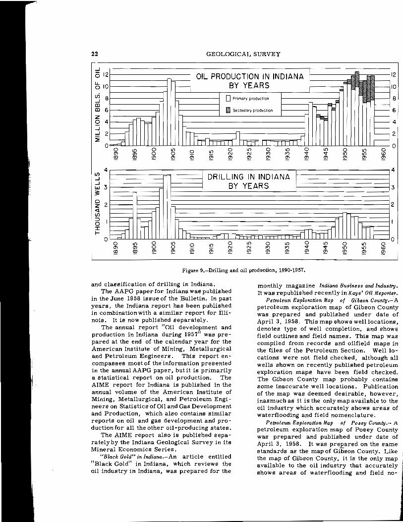
Reports on oil developments in lndiana.-Statistics on exploratory drilling in Indiana for 1957 were prepared for the American Association of Petroleum Geologists Committee on Statistics of Exploratory Drilling. These statistics are compiled continuously through the year so that the annual figures may be quickly completed at the end of the calendar year (fig. 9). The statistics on exploratory drilling in Indiana constitute part of a statistical summary on exploratory drilling in the United States which is compiled by the chairman of the SED Committee and is published annually in the June issue of the Bulletin of the American Association of Petroleum Geologists. Mr. B. VV. Blampied, chairman of the SED Committee of the AAPG, visited the Petroleum Section in June 1958 and expressed complete satisfaction with the manner in which statistics for Indiana are being handled.
The annual AAPG report "Developments in Indiana in 1957" was prepared in December 1957. Its principal theme is exploratory drilling. Preparation of this report is made possible by maintenance of a weekly tabulation
22 GEOLOGICAL SURVEY
...J
0 12
LL. 0 10
(/) 8...J (D (D 6 z 0 4 = ...J ...J 82 ~
0 o o en CD ~
4 (/) ...J ...J W 3
:3: a z 2 « (/) r--- ::::> 0 ~mJ: .......
o o o en o CD Q2
OIL PRODUCTION IN INDIANA I
- BY YEARS 10
oPrimary production 8:• 12
mI Secondary producTion 1-1-- ~ F~~
h .......
I{)
o Q2
h
n J[ rr-,FA I fillii I lnnHl I I I I I I o oI{)
N N I{)
Q2 Q2 Q2
DRILLING IN INDIANA BY YEARS
I{)
o en
II 111 o N Q2
I{)
N Q2
:flIFFITff o <:t en
o I{)
Q2
Figure 9.-Drilling and oil production, 1890-1957.
r---- 6 r--- r----. 4
2~ o I{) I{)
Q2
4
3
: 2
nlF= o I{) I{)
Q2
and classification of drilling in Indiana. The AAPG paper for Indiana was published
in the June 1958 issue of the Bulletin. In past years, the Indiana report has been published in combination with a similar report for Illi nois. It is now published separately.
The annual report "Oil development and production in Indiana during 1957" was prepared at the end of the calendar year for the American Institute of Mining, Metallurgical and Petroleum Engineers. This report encompasses most of the information presented in the annual AAPG paper, but it is primarily a statistical report on oil production. The AIME report for Indiana is published in the annual volume of the American Institute of Mining, Metallurgical, and Petroleum Engineers on Statistics of Oil and Gas Development and Production, which also contains similar reports on oil and gas development and production for all the other Oil-producing states.
The AIME report also is published separatelyby the Indiana Geological Survey in its Mineral Economics Series.
"Black Gold" in Indiana.-An article entitled "Black Gold" in Indiana, which reviews the oil industry in Indiana, was prepared for the
monthly magazine Indiana Busines8 and Industry. It was republished recently in Kay8' Oil Reporter.
Petroleum Ezploration Map of Gibson County.-A petroleum exploration map of Gibson County was prepared and published under date of April 3,1958. This map shows well locations, denotes type of well completion, and shows field outlines and field names. This map was compiled from records and oilfield maps in the files of the Petroleum Section. Well locations were not field checked, although all wells shown on recently published petroleum exploration maps have been field checked. The Gibson County map probably contains some inaccurate well locations. Publication of the map was deemed deSirable, however, inasmuch as it is the only map available to the oil industry which accurately shows areas of waterflooding and field nomenclature.
Petroleum Ezploration Map of Posey County.- }\ petroleum exploration map of Posey County was prepared and published under date of April 3, 1958. It was prepared on the same standards as the map of Gibson County. Like the map of Gibson County, it is the only map available to the oil industry that accurately shows areas of waterflooding and field no
23 GEOLOGICAL SURVEY
menclature. Well records of Daviess, Knoll!, and Sullivan Coun
ties.- The purpose of these 3 projects was to remove inaccuracies from the well records of 3 counties. The projects entailed checking wells in the field for location and elevation, correlation of drillers I logs and electric logs, review and indexing all well data, and compilation of petroleum exploration (well location) maps. The projects for Daviess and Knox Counties were completed, and the petroleum exploration maps were published April 3, 1958. The project for Sullivan County was started in July 1957 and is 50 percent complete.
Renault-AUrl! Vases-Ste. Genevieve study.- The purpose of this researchis to gain an understanding of the interrelationships of the Renault, Aux Vases, and Ste. Genevieve formations. The project was started nearly 3 years ago and is now 90 percent complete.
Cypress-Paint Creek-Bethel study.- The purpose of this research is to show the distribution of the lithologic units of the Cypress-Paint Creek-Bethel formations and the geographic and stratigraphic distribution of oil in the Cypress-Bethel unit. The project was started in October 1957, and it is estimated that it will be completed in July 1959.
Pipeline map.-The purpose of this project is to compile an accurate pipeline map of Indiana; the map is to be published in colors that will show distinctly the crude-oil pipelines, gas pipelines, and products pipelines. The project was begun in November 1957 and is to be completed in December 1958.
Sample directory.-The objective of this project is a publication that will show all well samples in the files of the Indiana Geological Survey as of July I, 1958. This project is made possible now only after years of upgrading the sample library. Typing on the tables for the sample directory was begun in June 1958, and it is estimated that the project will be completed in October 1958.
PRINCIPAL GEOLOGIST'S ACTIVITIES
By John B. Patton
The Principal Geologist of the Indiana Geological Survey serves as Chairman of the Geologic Names Committee, directs the work of the Minerals Statistician, is in charge of special projects such as the bibliography of Indiana geology and cooperative work with the Interstate Oil Compact Commission, and
acts for the State Geologist when he must be out of the State on official duty. In addition to these duties, the Principal Geologist also serves on important ad hoc committees such as the State Geologic Map Committee. Finally, he serves on independent research in stratigraphy and economic geology.
Disposal of oilfield brines.-Aspartof a project of the Research Committee of the Interstate Oil Compact Commission, the Geological Survey conducted a study of oilfield brine disposal in Indiana. A preliminary report, by T. A. Dawson, O. R. Holt, and J. B. Patton, was submitted to the Commission in December 1956. With the assistance of the Oil and Gas Division of the Indiana Department of Conservation, additional information covering regulations and their enforcement, and statistics was incorporated in the final report, "Brine disposal in Indiana, II byJ. B. Patton, T. A. Dawson, and H. R. Brown, submitted on April 15, 1958.
Reports on mineral industry in Indiana.-" The mineral industry of Indiana," an 18-page preprint from the United States Bureau of Mines Minerals Yearbook 1955, coauthored by D. F. Klyce of the Bureau of Mines and the Principal Geologist of the Indiana Geological Survey, was issued in February 1958. The Principal Geologist also was coauthor, with D. F. Klyce of "The mineral industry of Indiana in 1956," a chapter in the forthcoming Bureau of Mines Mineral Yearbook 1956. A 12-page summary of the chapter was issued as Area Report E-59 in January 1958.
Geologic nomenclature in Indiana.- The Geologic Names Committee has restudied the stratigraphy and nomenclature of all the geologic systems represented in Indiana. The committee also is setting up new charts showing the geologic names approved for use. within the Geological Survey.
Annotated bibliography of Indiana geology through 1955.-The annotated bibliography of Indiana geology, which has been in progress since 1947, is now in the hands of the Editor. This publication will contain approximately 3,500 items and will be ready for release in 1959.
Annotated bibliography of Indiana geology since 1955.-Work on the supplement to the bibliographyof Indiana geology, begun in September 1957, is complete from January 1956 through April 1958. All the important geological journals received by the Geology Library , were checked for articles concerning the geology of Indiana, were cited on 5-by 8-inch cards, and filed alphabetic ally by author.

24 GEOLOGICAL SURVEY
In the 8-month period from September through April, approximately 130 articles were cited. The index cards and citations are filed in the Geology Library.
PUBLICATIONS SECTION By Gerald S. Woodard
The responsibility of the Indiana Geological Survey does not end with the completion of its field or laboratory investigations. Knowledge derived from such studies of Indiana's geology and of her fuels and mineral resources also must be made available to the public. In order to disseminate its .many scientific data and conclusions and thereby make its research useful to the citizens and economy of the State, the Geological Survey is required to prepare and publish many maps and reports. Since 1945, the Survey has sought constantly to establish and maintain standards of soundness and effective clear presentation of its scientific findings and conclusions.
Between July 1, 1957, and June 30, 1958, the Publications Section sold 2,451 maps and 1,872 Geological Survey publications other than maps. In addition, 372 reports and maps were mailed to institutions on the domestic exchange list, and 215 reports and maps were sent to institutionl' on the foreign exchange list. An additional 1, 130 maps and reports were distributed without charge to individuals, libraries, and companies in the United States and abroad.
More than 3,800 companies, schools, and individuals received announcements of the Indiana Geologic Field Conference and of new publications. During the fiscal year, 5 general publications announcements and 1 field conference announcement were mailed. Between July 1, 1957, and June 30, 1958, the Publications Section served 274 office customers, received I, 875 letters , and answered 508 inquiries concerning geologic information and publications.
PUBLICATIONS RELEASED BY THE GEOLOGICAL SURVEY DURING 1957-58
Bulletins
Pinsak, A. P., 1957, Subsurface stratigraphy of the Salem Limestone and as
sociated formations in Indiana: Bull. H, 62 p., 5 pIs., 8 figs., 2 tables.
Perry, T. G., and Smith, N. M., 1958, The Meramec-Chester and intraChester boundaries and associated strata in Indiana: Bull. 12, 110 p., 6 pIs., 1 fig.
Circulars
Greenberg, S. S. , Bundy, W. M. and McGregor, D. J., 1958, Guide to some minerals and rocks in Indiana: Circ. 4, 60 p., 6 figs., 5 tables.
Field Conference Guidebooks
Indiana Geological Survey, 1957, Rocks associated with the MississippianPennsylvanian unconformity in southwestern Indiana: Field Conf. Guidebook 9, 42 p., 4 pIs., 3 figs.
Mineral Economics Series
Dawson, T. A., and Carpenter, G. L., 1957, Oil development and production in Indiana during 1956: Min. Econ. Ser. 3, 11 p., 1 map, 2 tables.
Reports of Progress
Murray, H. H., 1957, Pennsylvanian underclays - -potential bonding clays for use in foundries: Rept. Progress 11, 27 p., 6 figs., 6 tables.
County Base Maps
Moran, W. H., and Heisterkamp, A. J., November 20, 1951, rev. March 1, 1958, Base map of Crawford County, Ind.: Base Map 13.
Moran, W. H., and Peace, J. E., January 11, 1951, rev. October 15, 1957, Base map of Daviess County, Ind.: Base Map 14.
Moran, W. H., and Heisterkamp, A. J., January 20, 1953, rev. November 15, 1957, Base map of Hendricks County, Ind.: Base Map 32.
j Moran, W. H., and Baker, L. R., June
1, 1950, rev. December 1, 1957, Base.

25 GEOLOGICAL SURVEY
map of Knox County, Ind.: Base Map 42.
Moran, W. H., February 26, 1951, rev. November 15, 1957, Base map of Miami County, Ind.: Base Map 52.
Moran, W. H., and Heisterkamp, A. J., October 19, 1951, rev. November 1, 1957, Base map of Orange County, Ind.: Base Map 59.
Moran, W. H., and Peace, J. E., September 15, 1949, rev. November 1, 1957, Base map of Parke County, Ind.: Base Map 61.
Moran, W. H., and Heisterkamp, A. J., January 12, 1949, rev. February 1, 1958, Base map of Sullivan County, Ind.: Base Map 77.
Moran, W. H., and Heisterkamp, A. J., November 30, 1951, rev. November 1, 1957, Base map of Washington County, Ind.: Base Map 88.
Petroleum Exploration Maps
Carpenter, G. L., and Lowrance, M. A., November I, 1953, rev. Apri13, 1958, Well location map of Warrick County, Ind. , showing total deptbof wells: Petroleum Explor. Map 3A.
Carpenter, G. L., and Lowrance, M. A., November 1, 1953, rev. April 3, 1958, Well location map of Warrick County, Ind.: Petroleum Explor. Map 3B.
Keller, Stanley, April 3, 1958, Well 10cation map of Vigo County, Ind., showing total depth of wells: Petroleum Explor. Map SA.
Keller, Stanley, April 3, 1958, Well 10cation map of Vigo County, Ind.: Petroleum Explor. Map 5B.
Fiandt, Dallas, September 18, 1951, rev. April 3, 1958, Well location map of Martin County, Ind.: Petroleum Explor. Map 12.
Fiandt, Dallas, September 18, 1951, rev. April 3, 1958, Well location map of Martin County, Ind.. showing total
depth of wells: Petroleum Explor. Map 12A.
Carpenter, G. L., November 1, 1953, rev. April 3. 1958, Well location map of Greene County, Ind., showing total depth of wells: Petroleum Explor. Map 13A.
Carpenter, G. L., November 1, 1953, rev. April 3, 1958, Well location map of Greene County, Ind.: Petroleum Explor. Map 13B.
Carpenter, G. L., November 1, 1953, rev. April 3, 1958, Well location map of Clay County, Ind., showing total depth of wells: Petroleum Explor. Map 14A.
Carpenter, G. L., November 1, 1953, rev. April 3, 1958, Well location map of Clay County, Ind.: Petroleum Explor. Map 14B.
Carpenter, G. L., November I, 1953, rev. April 3, 1958, Well location map of Parke County, Ind., showing total depth of wells: Petroleum Explor. Map 15A.
Carpenter, G. L., November I, 1953, rev. April 3, 1958, Well location map of Vermillion County, Ind., showing total depth of wells: Petroleum Explor. Map 16A.
Carpenter, G. L., November 1, 1953, rev. April 3, 1958, Well location map of Fountain County, Ind., showing total depth of wells: Petroleum Explor. Map 17A.
Carpenter, G. L., November I, 1953, rev. April 3, 1958, Well location map of Owen County, Ind., showing total depth of wells: Petroleum Explor. Map 18A.
Carpenter, G. L., November 1, 1953, rev. April 3, 1958, Well locaHon map of Putnam County, Ind., showing total depth of wells: Petroleum Explor. Map 19A.
Carpenter, G. L., November 1, 1953, checked without revision April 3, 1958,
26 GEOLOGICAL SURVEY
Well location map of Montgomery County, Ind., showing total depth of wells: Petroleum Explor. Map 20A.
Carpenter, G. L., November I, 1953, rev. April 3, 1958, Well location map of Dubois County, Ind., showing total depth of wells: Petroleum Explor. Map 21A.
Carpenter, G. L., November 1, 1953, rev. April 3, 1958, Well location map of Dubois County, Ind.: Petroleum Explor. Map 21B.
Fiandt, Dallas, March 12, 1952, rev. April 3, 1958, Well location map of Jackson County, Ind., showing total depth of wells: Petroleum Explor. Map 22A.
Fiandt, Dallas, May 1, 1951, rev. April 3, 1958, Well location map of Knox County, Ind.: Petroleum Explor. Map 23.
Fiandt, Dallas, May I, 1951, rev. April 3, 1958, Well location map of Knox County, Ind., showing total depth of wells: Petroleum Explor. Map 23A.
Hyer, D. E., J,uly 18, 1951, rev. April 3, 1958, Well location map of Monroe County, Ind., showing total depth of wells: Petroleum Explor. Map 24A.
Hyer, D. E., and Pennington, W. D., August 8, 1951, rev. April 3, 1958, Well location mapof Lawrence County, Ind., showing total depth of wells: Petroleum Explor. Map 25A.
Fiandt, Dallas, September 18, 1951, rev. April 3, 1958, Well location map of Daviess County, Ind.: Petroleum Exploration Map 26.
Fiandt, Dallas, September 18, 1951, rev. April 3, 1958, Well location map of Daviess County, Ind., showing total depth of wells: Petrole urn Explor. Map 26A.
Hyer, D. E., November 3D, 1951, rev. April 3, 1958, Well location map of Orange County, Ind., showing total depth of wells: Petroleum Explor. Map
27A.
Hyer, D. E., November 30, 1951, rev. April 3, 1958, Well location map of Crawford County, Ind., showing total depth of wells: Petroleum Explor. Map 28A.
Hyer, D. E., November 30, 1951, checked without revision April 3, 1958, Well location map of Washington County, Ind., showing total depth of wells: Petroleum Explor. Map 29A.
Hyer, D. E., and Carpenter, G. L., December21, 1951, rev. April 3, 1958, Well location map of Harrison County, Ind.: Petroleum Explor. Map 30.
Hyer, D. E., and Carpenter, G. L., December21, 1951, rev. April 3, 1958, Well location map of Harrison County, Ind., showing total depth of wells: Petroleum Explor. Map 30A.
Fiandt, Dallas, March 12, 1952, rev. April 3, 1958, Well location map of Brown County, Ind. , showing total depth of wells: Petroleum Explor. Map 31A.
Fiandt, Dallas, March 12, 1952, rev. April 3, 1958, Well location map of Bartholomew County, Ind., showing total depth of wells: Petroleum Explor. Map 32A.
Lowrance, M. A. , March 2, 1953, checked without revision April 3, 1958, Well location map of Hendricks County, Ind. , showing total depth of wells: Petroleum Explor. Map 33A.
Carpenter, G. L., March 2, 1953, rev. April 3, 1958, Well location map of Marion County, Ind., showing total depth of wells: Petroleum Explor. Map 34A.
Lowrance, M. A., March 2, 1953, rev. April 3, 1958, Well location map of Morgan County, Ind., showing total depth of wells: Petroleum Explor. Map 35A.
Lowrance, M. A. , March 2, 1953, checked without revision April 3, 1958, Well location map of Johnson County, Ind.,

27 GEOLOGICAL SURVEY
showing total depth of wells: Petroleum Explor. Map 36A.
Carpenter, G. L., March 2, 1953, rev. April 3, 1958, Well location map of Tippecanoe County, Ind., showing total depth of wells: Petroleum Explor. Map 37A.
Carpenter, G. L., November 1, 1953, checked without revision April 3, 1958, Well location map of Warren County, Ind., showing total depth of wells: Petroleum Explor. Map 38A.
Carpenter, G. L., and Riely, S. L., October 1, 1954, rev. April 3, 1958, Well location map of Spencer County, Ind.: Petroleum Explor. Map 39.
Carpenter, G. L., and Riely, S. L., October 1, 1954, rev. April 3, 1958, Well location map of Spencer County, Ind., showing total depth of wells: Petroleum Explor. Map 39A.
Carpenter, G. L., and Sullivan, D. M., October 1, 1954, rev. April 3, 1958, Well location map of Perry County, Ind.: Petroleum Explor. Map 40.
Carpenter, G. L., and Sullivan, D. M., October 1, 1954, rev. April 3, 1958, Well location map of Perry County, Ind., showing total depth of wells: Petroleum Explor. Map 40A.
Carpenter, G. L., October 1, 1954, checked without revision April 3, 1958, Well location map of Benton County, Ind., showing total depth of wells: Petroleum Explor. Map 41A.
Carpenter, G. L., October 1, 1954, checked without revision April 3, 1958, Well location map of White County, Ind., showing total depth of wells: Petroleum Explor. Map 42A.
Carpenter, G. L., October 1, 1954, checked without revision April 3, 1958, Well location map of Carroll County, Ind., showing total depth of wells: Petroleum Explor. Map 43A.
Carpenter, G. L., October 1, 1954, rev. April 3, 1958, Well location map of
Clinton County, Ind., showing total depth of wells: Petroleum Explor. Map 44A.
Carpenter, G. L., October 1, 1954, rev. April 3, 1958, Well location map of Boone County, Ind., showing total depth of wells: Petroleum Explor. Map 45A.
Carpenter, G. L., October 1, 1954, rev. April 3, 1958, Well location map of Jennings County, Ind., showing total depth of wells: Petroleum Explor. Map 46A.
Carpenter, G. L., October 1, 1954, rev. April 3, 1958, Well location map of Jefferson County, Ind., showing total depth of wells: Petroleum Explor. Map 47A.
Carpenter, G. L., October 1, 1954, checked without revision April 3, 1958, Well location map of Scott County, Ind., showing total depth of wells: Petroleum Explor. Map 48A.
Carpenter, G. L., October 1, 1954, checked without revision April 3, 1958, Well location map of Clark County, Ind., showing total depth of wells: Petroleum Explor. Map 49A.
Carpenter, G. L., October 1, 1954, checked without revision April 3, 1958, Well location map of Floyd County, Ind., showing total depth of wells: Petroleum Explor. Map 50A.
Carpenter, G. L., Holt, O. R., and Sullivan, D. M., March 1, 1956, rev. April 3, 1958, Well location map of Pike County, Ind.: Petroleum Explor. Map 51.
Carpenter, G. L., Holt, O. R., and Sullivan, D. M., March 1, 1956, rev. April 3, 1958, Well location map of Pike County, Ind., showing total depth of wells: Petroleum Explor. Map 51A.
Carpenter, G. L., Holt, O. R., and Sullivan, D. M., March 1, 1956, rev. April 3, 1958, Well location map of Vanderburgh County, Ind.: Petroleum Explor. Map 52.

28 GEOLOGICAL SURVEY
Carpenter, G. L., Holt, O. R., and Sullivan, D. M., March 1, 1956, rev. April 3, 1958, Well location map of Vanderburgh County, Ind., showing total depth of wells: Petroleum Explor. Map 52A.
Sullivan, D. M. , and Abbott, G. A., April 3, 1958, Preliminary well location map of Gibson County, Ind.: Petroleum Explor. Map 53.
Carpenter, G. L., and Abbott, G. A., April 3, 1958, Preliminary welliocation map of Posey County, Ind.: Pe
troleum Explor. Map 54.
Preliminary Coal Maps
Wier, C. E., 1958, Distribution, structure, and mined areas of coals in Warrick County, Ind.: Prelim. Coal Map 7.
A price list of geologic publications of Indiana may be obtained by writing to the Publications Section, Geological Survey, Indiana University, Bloomington, Ind.