Embed Size (px)
Citation preview

2333-14
Workshop on Science Applications of GNSS in Developing Countries (11-27 April), followed by the: Seminar on Development and Use of the Ionospheric
NeQuick Model (30 April-1 May)
DI FAZIO Antonella
11 April - 1 May, 2012
Telespazio S. p. A. Via Tiburtina 965
00156 Rome ITALY
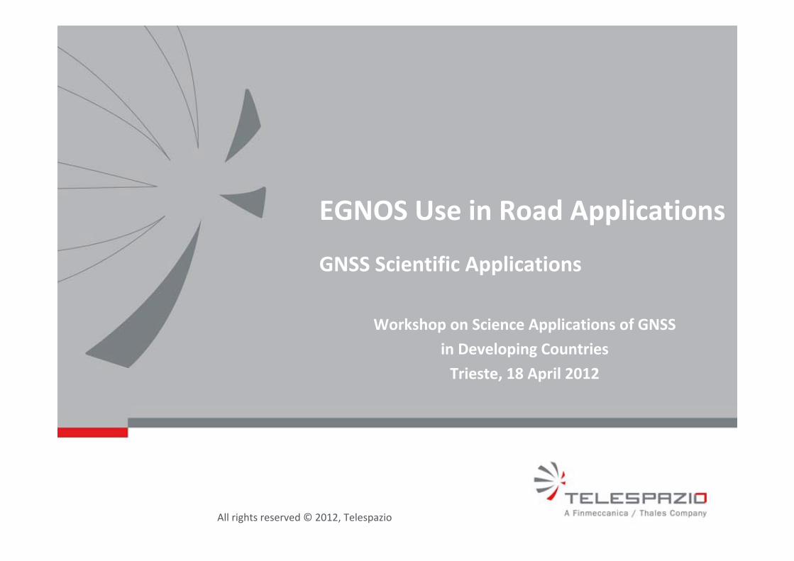
EGNOS Use in Road Applications
All rights reserved © 2012, Telespazio
EGNOS Use in Road Applications
GNSS Scientific Applications
Workshop on Science Applications of GNSS
in Developing Countries
Trieste, 18 April 2012
All rights reserved © 2012, Telespazio
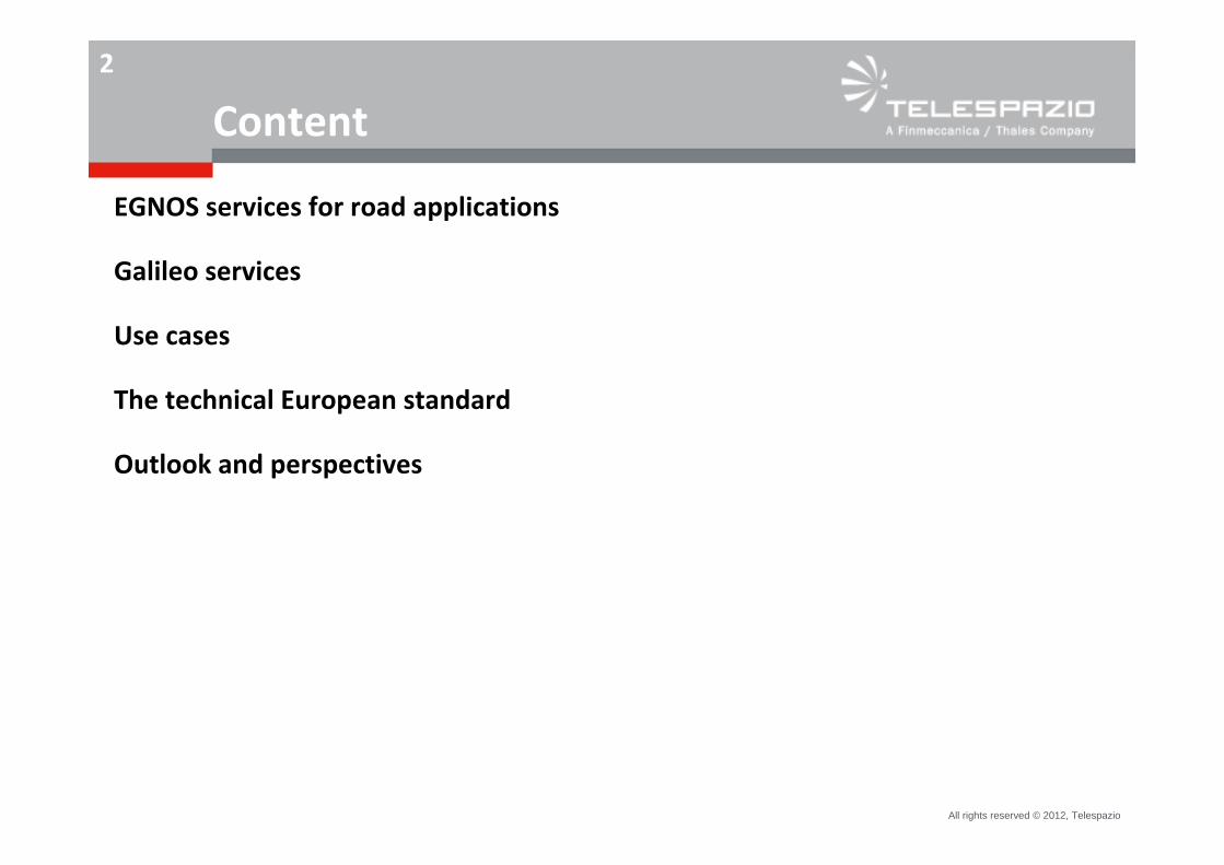
2
Content
EGNOS services for road applications
Galileo services
Use cases
The technical European standard
Outlook and perspectives
All rights reserved © 2012, Telespazio
3
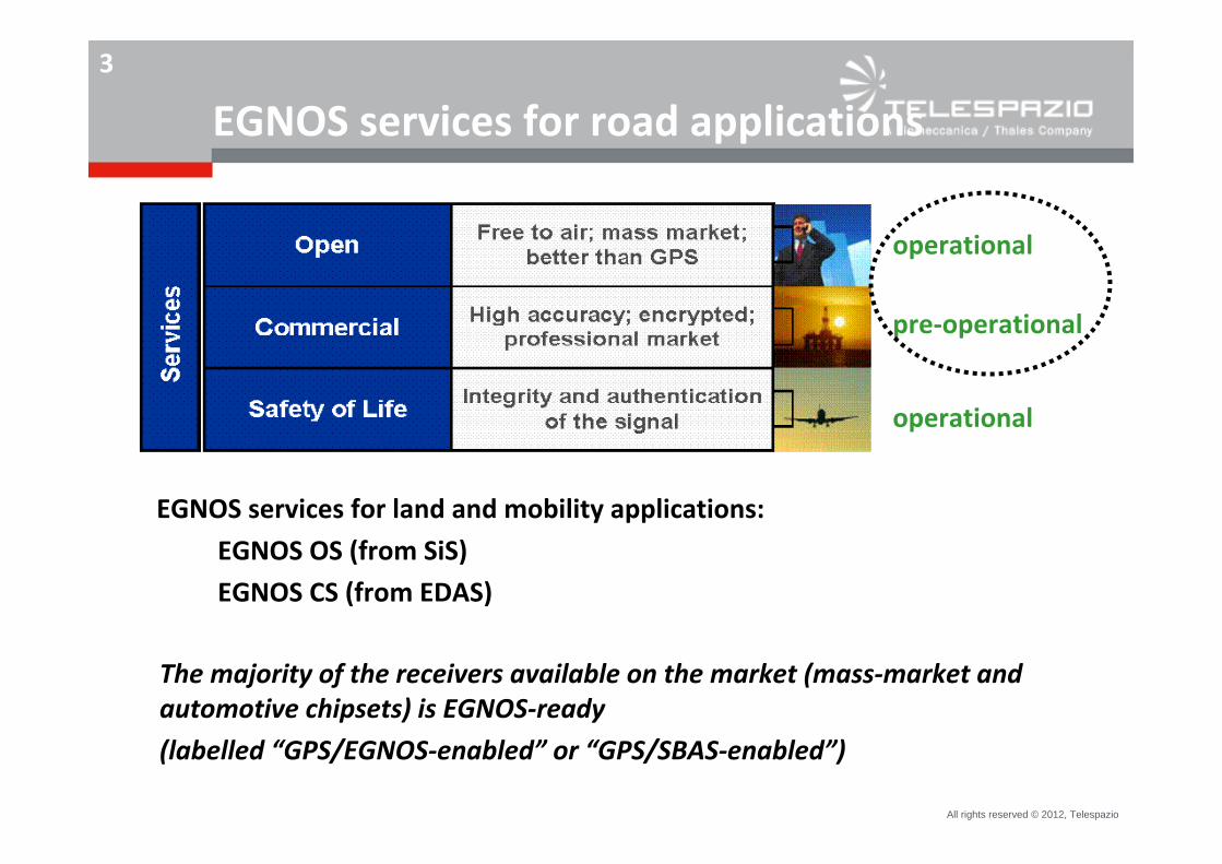
EGNOS services for road applications
operational
operational
pre‐operational
EGNOS services for land and mobility applications:
EGNOS OS (from SiS)
EGNOS CS (from EDAS)
The majority of the receivers available on the market (mass‐market and automotive chipsets) is EGNOS‐ready
(labelled “GPS/EGNOS‐enabled” or “GPS/SBAS‐enabled”)
All rights reserved © 2012, Telespazio
4
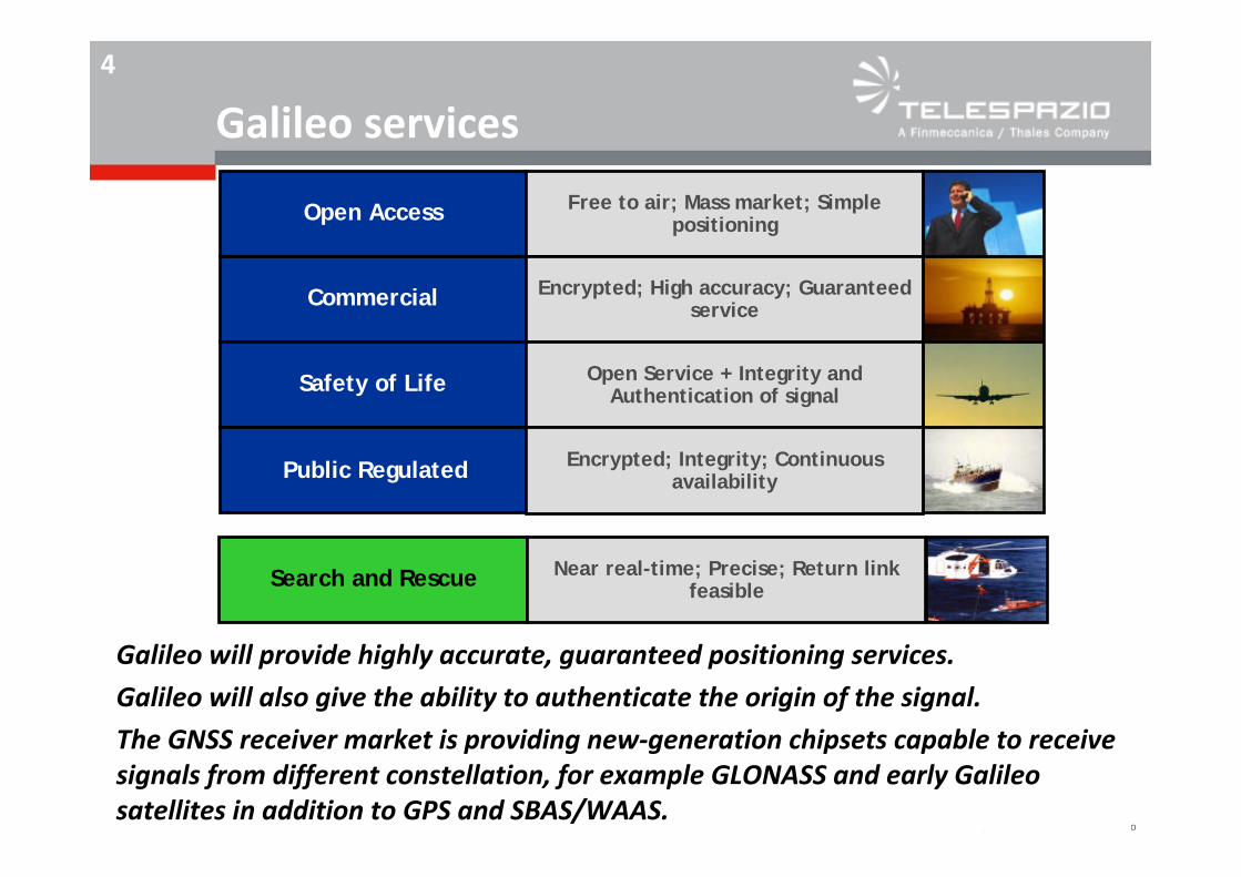
Galileo services
Galileo will provide highly accurate, guaranteed positioning services.
Galileo will also give the ability to authenticate the origin of the signal.
The GNSS receiver market is providing new‐generation chipsets capable to receive signals from different constellation, for example GLONASS and early Galileo satellites in addition to GPS and SBAS/WAAS.
Open Access
Commercial
Safety of Life
Search and Rescue
Free to air; Mass market; Simple positioning
Encrypted; High accuracy; Guaranteed service
Open Service + Integrity and Authentication of signal
Encrypted; Integrity; Continuous availability
Near real-time; Precise; Return link feasible
Public Regulated
All rights reserved © 2012, Telespazio
5
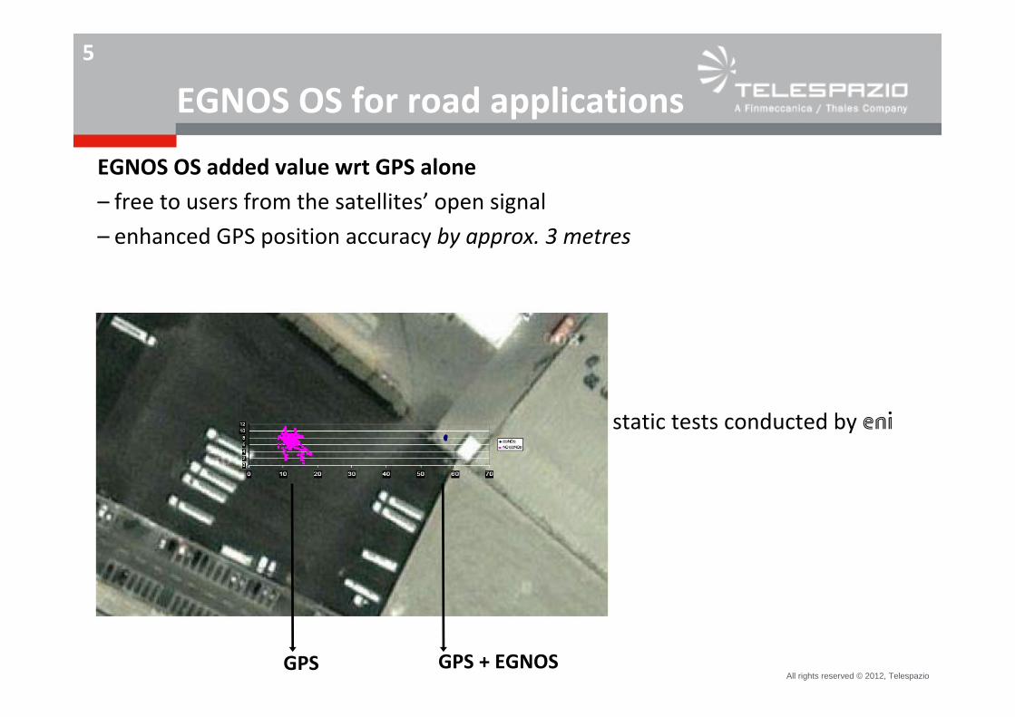
EGNOS OS for road applications
EGNOS OS added value wrt GPS alone
– free to users from the satellites’ open signal
– enhanced GPS position accuracy by approx. 3 metres
GPS + EGNOSGPS
static tests conducted by eni
All rights reserved © 2012, Telespazio
6
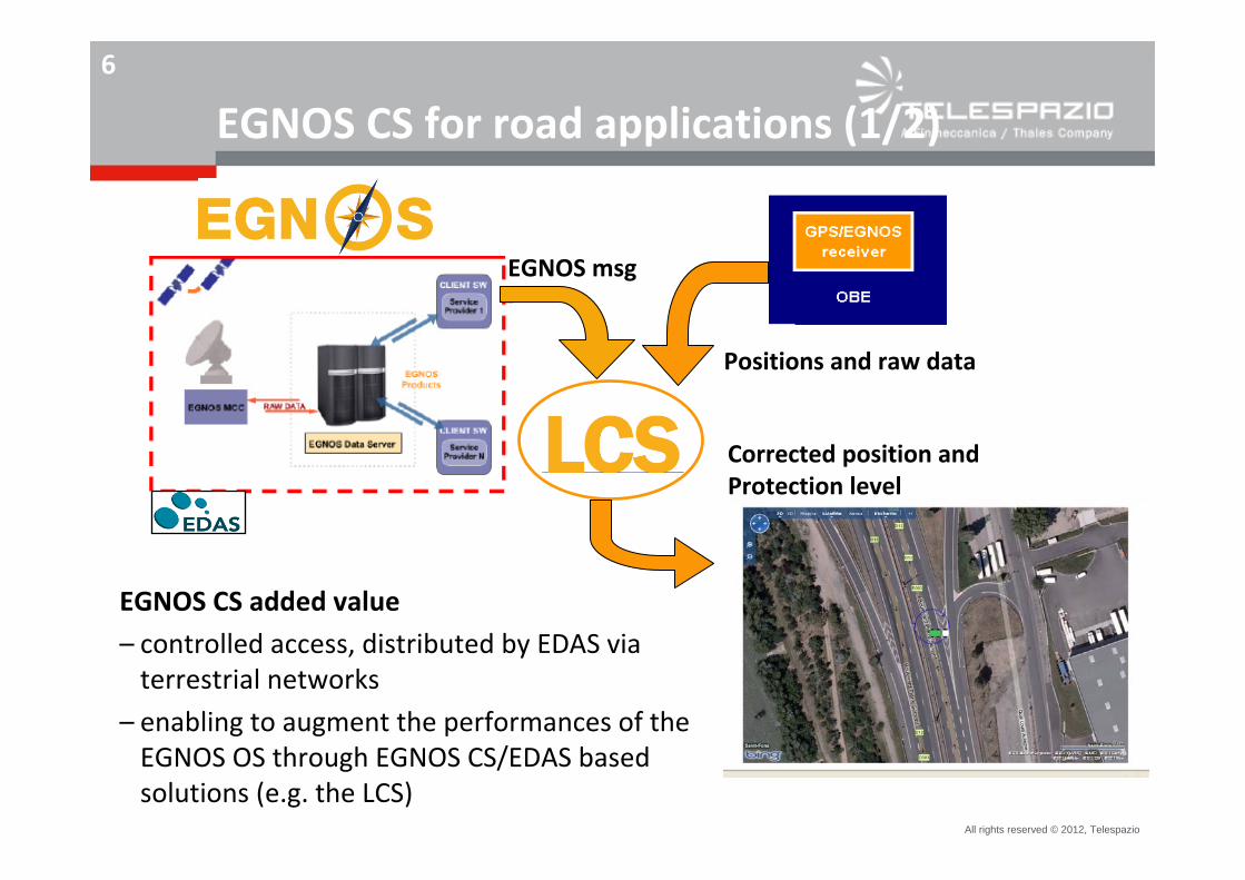
EGNOS CS for road applications (1/2)
Value‐AddedService Provider
EGNOS msg
Positions and raw data
Corrected position and Protection level
EGNOS CS added value
– controlled access, distributed by EDAS via terrestrial networks
– enabling to augment the performances of the EGNOS OS through EGNOS CS/EDAS based solutions (e.g. the LCS)
All rights reserved © 2012, Telespazio
7
EGNOS CS for road applications (2/2)
EGNOS CS added value wrt GPS alone (through the LCS)– improves the availability of the EGNOS OS
– (wrt EGNOS OS) further enhances GPS position accuracy by approx. 4 metres
– processes the EGNOS integrity into the “protection level”, providing the qualification/ confidence in the position information
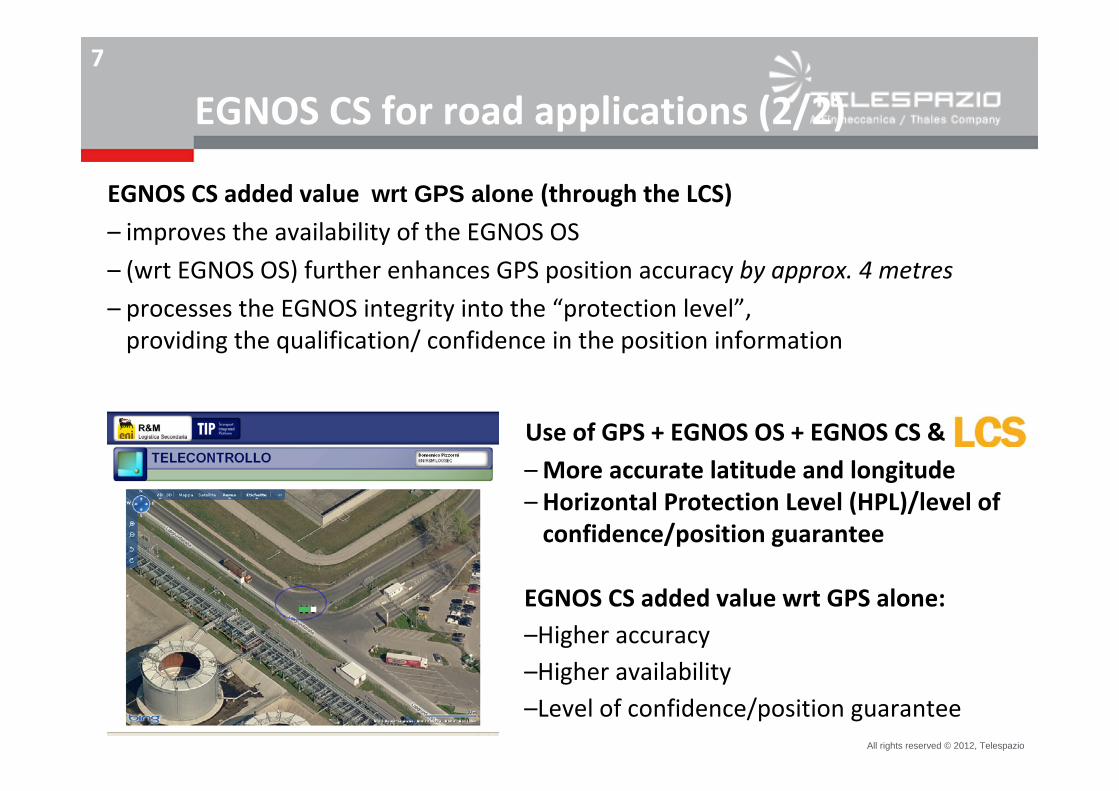
Use of GPS + EGNOS OS + EGNOS CS &–More accurate latitude and longitude– Horizontal Protection Level (HPL)/level of confidence/position guarantee
EGNOS CS added value wrt GPS alone:–Higher accuracy–Higher availability–Level of confidence/position guarantee
All rights reserved © 2012, Telespazio
8
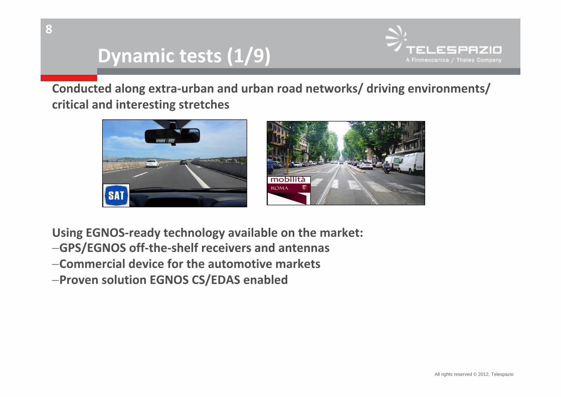
Dynamic tests (1/9)Conducted along extra‐urban and urban road networks/ driving environments/ critical and interesting stretches
Using EGNOS‐ready technology available on the market:GPS/EGNOS off‐the‐shelf receivers and antennasCommercial device for the automotive marketsProven solution EGNOS CS/EDAS enabled
All rights reserved © 2012, Telespazio
9
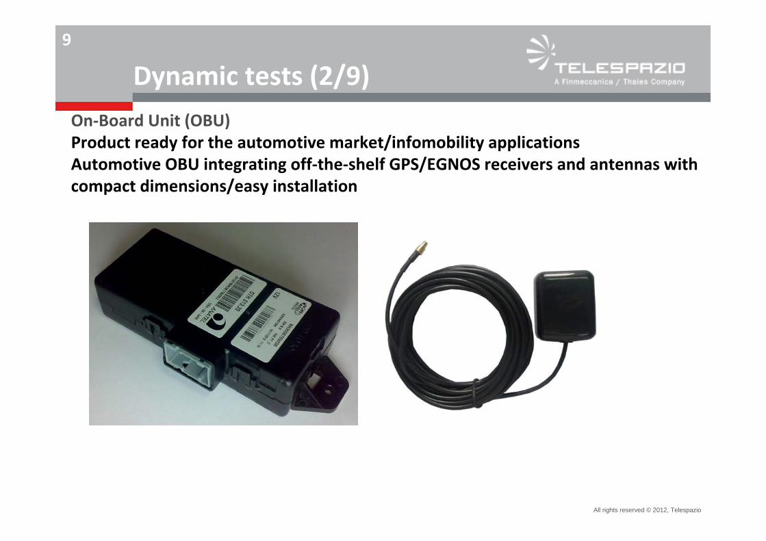
Dynamic tests (2/9)On‐Board Unit (OBU)Product ready for the automotive market/infomobility applications Automotive OBU integrating off‐the‐shelf GPS/EGNOS receivers and antennas with compact dimensions/easy installation
All rights reserved © 2012, Telespazio
10
Dynamic tests (3/9)
True path measurement:
– A reference trajectory, “true path”, was calculated in post‐processing, through a kinematic differential GPS method, by using GPS L1 and L2 carrier phase measurements, combined with INS (Inertial Navigation System) measurements.
– The differential GPS L1 and L2 carrier measurements were collected using a reference receiver installed near each test location with an inter‐receiver distance not exceeding 20 km. The GPS reference receiver was geo‐referenced via a dedicated GPS network solution (based on a continuous/24h at least for two days data collection campaign). A NovAtel FLEXG2‐V2‐L1L2 has been used a GPS reference with a NovAtel dual frequency antenna (GPS‐702GG).
– An integrated precision GPS/INS system (OxTS * RT2002 dual frequency GPS/INS system) has been used as rover. The combination with INS is aimed at having smooth trajectories free from jumps, even in difficult GPS environments.
* Oxford Technical Solution
All rights reserved © 2012, Telespazio
11
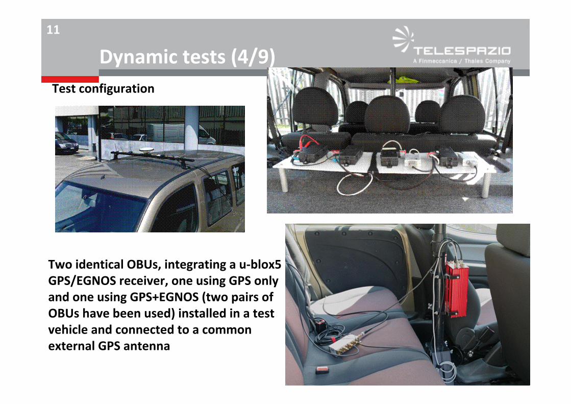
Dynamic tests (4/9)
Two identical OBUs, integrating a u‐blox5 GPS/EGNOS receiver, one using GPS only and one using GPS+EGNOS (two pairs of OBUs have been used) installed in a test vehicle and connected to a common external GPS antenna
Test configuration
All rights reserved © 2012, Telespazio
12
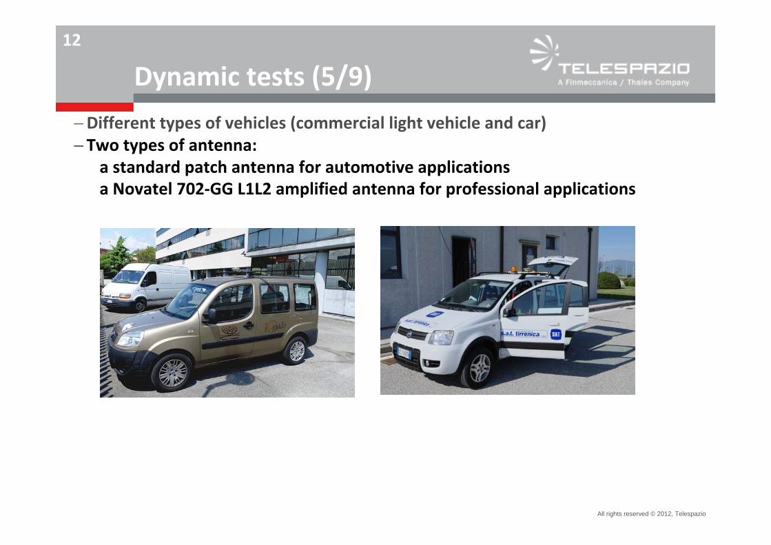
Dynamic tests (5/9)
Different types of vehicles (commercial light vehicle and car)Two types of antenna:
a standard patch antenna for automotive applicationsa Novatel 702‐GG L1L2 amplified antenna for professional applications
All rights reserved © 2012, Telespazio
13
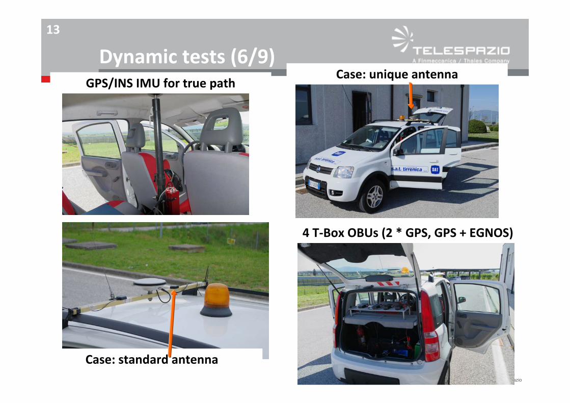
Dynamic tests (6/9)GPS/INS IMU for true path
Case: unique antenna
Case: standard antenna
4 T‐Box OBUs (2 * GPS, GPS + EGNOS)
All rights reserved © 2012, Telespazio
14
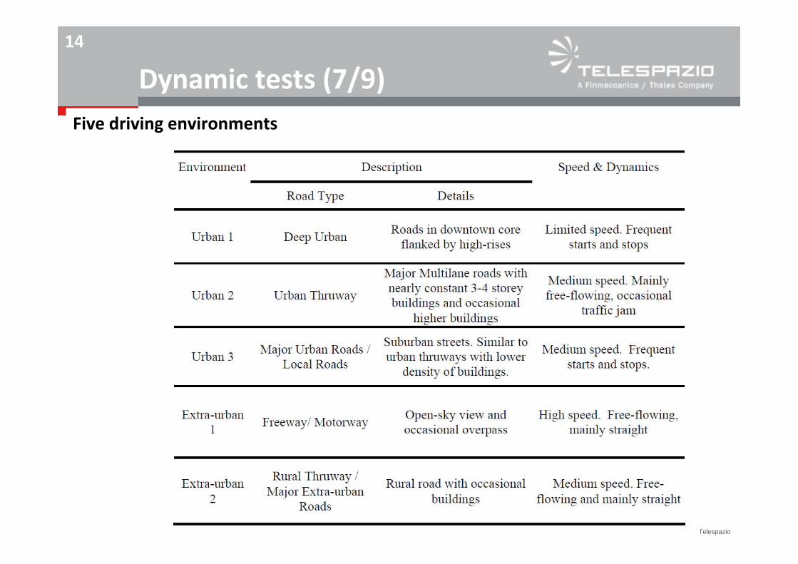
Dynamic tests (7/9)Five driving environments
All rights reserved © 2012, Telespazio
15
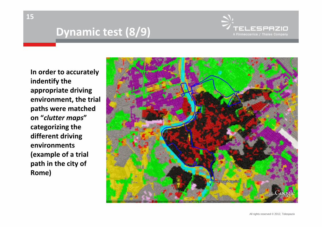
Dynamic test (8/9)
In order to accurately indentify the appropriate driving environment, the trial paths were matched on “clutter maps”categorizing the different driving environments (example of a trial path in the city of Rome)
All rights reserved © 2012, Telespazio
16
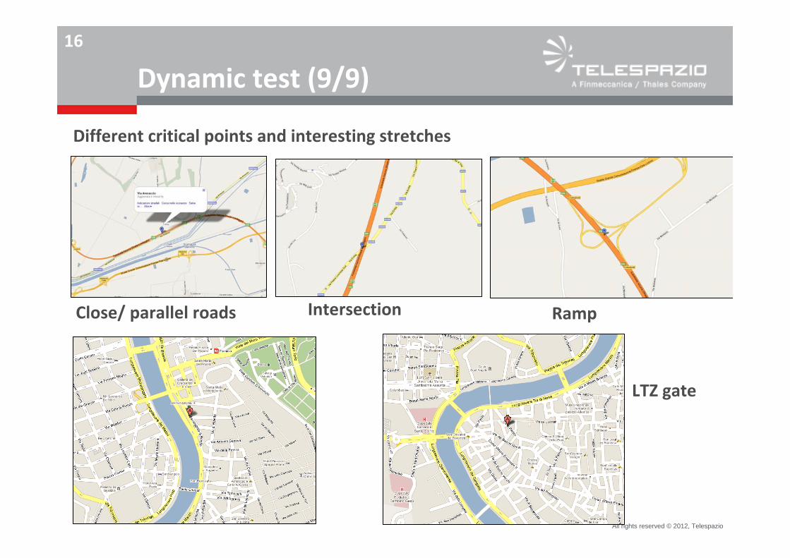
Dynamic test (9/9)
Different critical points and interesting stretches
Close/ parallel roads Intersection Ramp
LTZ gate
All rights reserved © 2012, Telespazio
17
Dynamic test results (1/8)
Performances assessment
Measurements of:
Horizontal accuracy of the position wrt to a reference trajectory (true path)HPLCases GPS vs GPS + EGNOS OS vs GPS + EGNOS CS/ EDAS
Standard tools for data analysis (e.g. GPSTk, GrafNav, PEGASUS)
All rights reserved © 2012, Telespazio
18
Dynamic tests results (2/8)
EGNOS OS enhances position accuracy wrt GPS: Accuracy improvement wrt GPS ranges from 0,1 m to 3,7 m (on average, also in case of dense tall buildings/ foliage conditions/ urban roads)
EGNOS CS/EDAS further enhances position accuracy wrt GPS and provides level of guarantee of position/ capability to qualify position data:Horizontal accuracy improvement wrt GPS ranges from 0,1 m to 4 m (on average, also in case of dense tall buildings/ foliage conditions/ urban roads)“Protection level”
These results are independent from the type of receivers.The type of antenna (professional amplified antenna versus standard patch antenna) has some impacts on the position accuracy (measured with GPS and with GPS + EGNOS OS): better performances in the case of the a Novatel 702‐GG L1L2 amplified antenna for professional applications.
All rights reserved © 2012, Telespazio
19
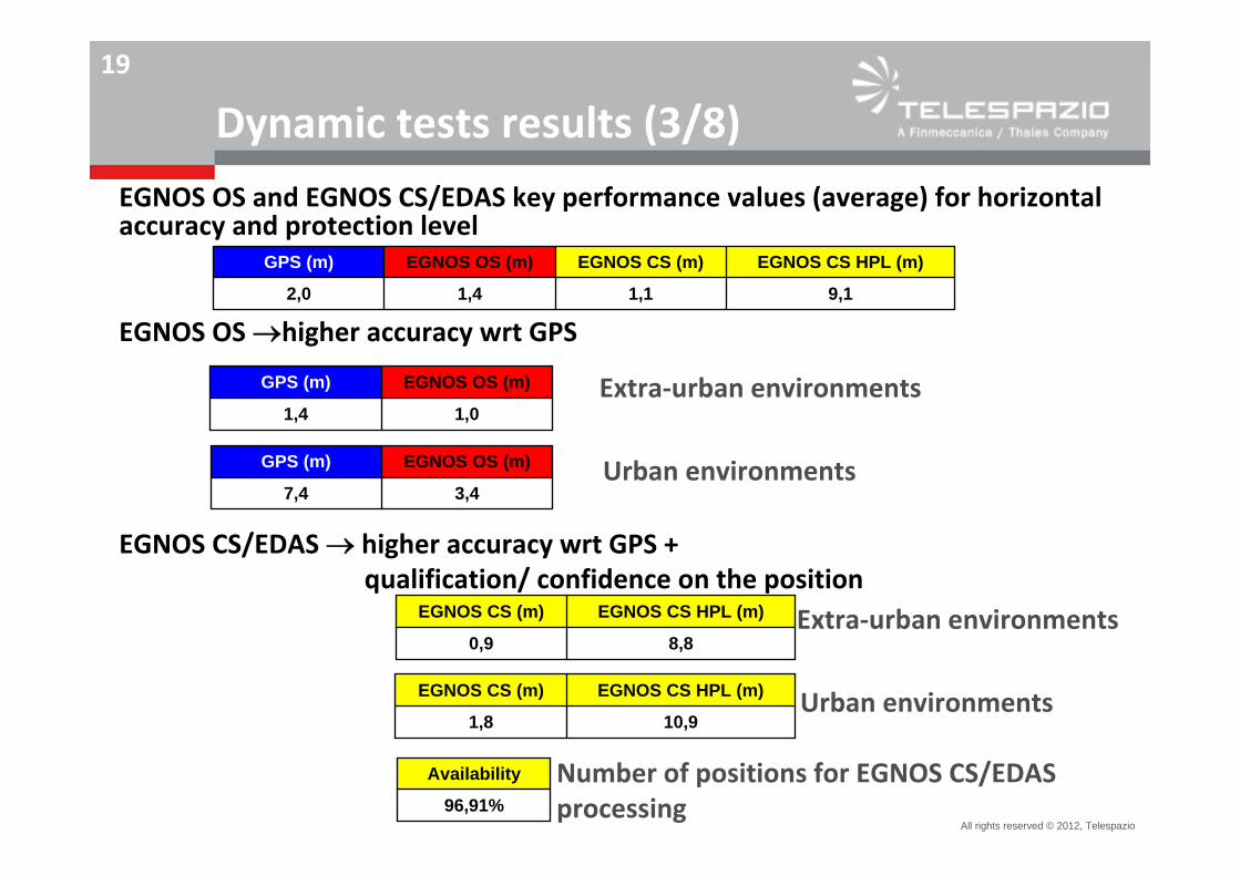
Dynamic tests results (3/8)
EGNOS OS and EGNOS CS/EDAS key performance values (average) for horizontal accuracy and protection level
EGNOS OS higher accuracy wrt GPS
EGNOS CS/EDAS higher accuracy wrt GPS + qualification/ confidence on the position
9,11,11,42,0
EGNOS CS HPL (m)EGNOS CS (m)EGNOS OS (m)GPS (m)
Number of positions for EGNOS CS/EDAS processing
8,80,9
EGNOS CS HPL (m)EGNOS CS (m)
10,91,8
EGNOS CS HPL (m)EGNOS CS (m)
96,91%
Availability
Extra‐urban environments
Urban environments
Extra‐urban environments
Urban environments3,47,4
EGNOS OS (m)GPS (m)
1,01,4
EGNOS OS (m)GPS (m)
All rights reserved © 2012, Telespazio
20
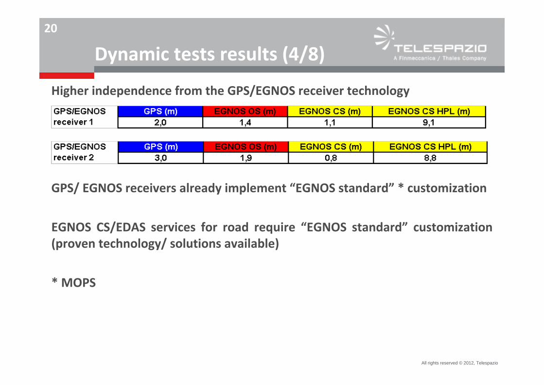
Dynamic tests results (4/8)
GPS/ EGNOS receivers already implement “EGNOS standard” * customization
EGNOS CS/EDAS services for road require “EGNOS standard” customization (proven technology/ solutions available)
* MOPS
Higher independence from the GPS/EGNOS receiver technology
All rights reserved © 2012, Telespazio
21
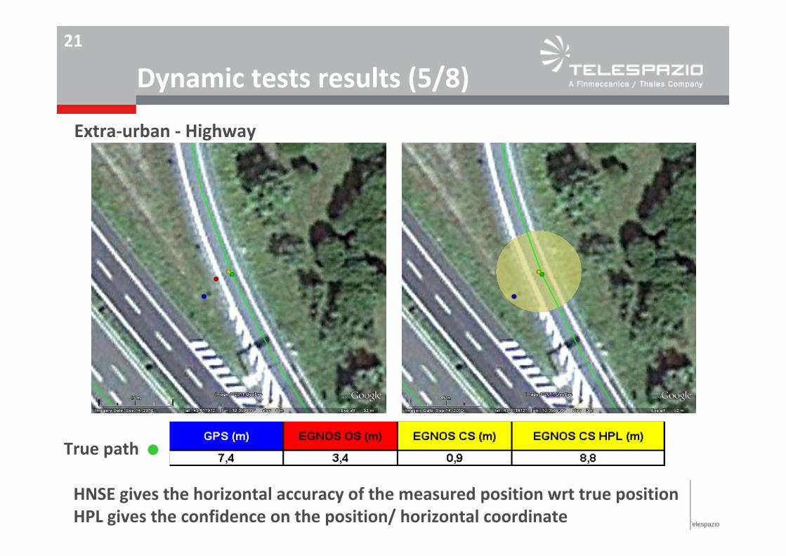
Dynamic tests results (5/8)
True path (
Extra‐urban ‐ Highway
HNSE gives the horizontal accuracy of the measured position wrt true positionHPL gives the confidence on the position/ horizontal coordinate
All rights reserved © 2012, Telespazio
22
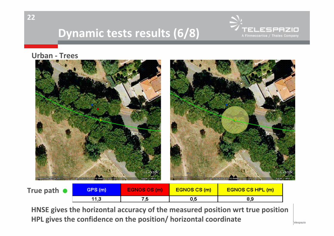
Dynamic tests results (6/8)
True path (
Urban ‐ Trees
HNSE gives the horizontal accuracy of the measured position wrt true positionHPL gives the confidence on the position/ horizontal coordinate
All rights reserved © 201 2, Telespazio
23
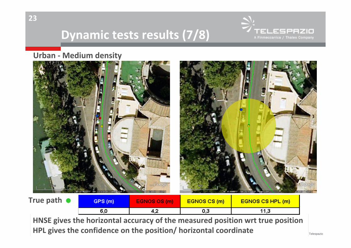
Dynamic tests results (7/8)
True path (
Urban ‐Medium density
HNSE gives the horizontal accuracy of the measured position wrt true positionHPL gives the confidence on the position/ horizontal coordinate
All rights reserved © 201 2, Telespazio
24
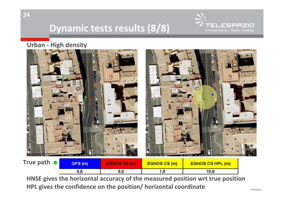
Dynamic tests results (8/8)
True path (
Urban ‐ High density
HNSE gives the horizontal accuracy of the measured position wrt true positionHPL gives the confidence on the position/ horizontal coordinate
All rights reserved © 2012, Telespazio
25
Use casesUse in real operations + added value/benefits validation
Use cases in extra‐urban road applications ‐ Toll Charger (TC): Toll charger/ tracking & tracing of third‐party service fleets ETC Service provider/ road charging
Use cases in urban road applications ‐ Urban mobility agency: City/ Tracking & tracing of touristic coaches City/ Tracking & tracing/ monitoring of access/ circulation in LTZ zones City/ Tracking & tracing/ monitoring of vehicles for goods delivery City/ Tracking & tracing of LTP fleets
All rights reserved © 2012, Telespazio
26
Use cases: road charging
TC 1 road charging
TC 2 tracking & tracing of third‐party service fleets, i.e. the specialised third‐party fleets subcontracted by the road operator to perform road maintenance and monitoring operations. The road operator has the need to tracking & trace such operations, for supervision/control andadministration purposes. Tracking & tracing is done by means of satellite navigation based devices installed on the service vehicles, data are used to control the subcontract service performance and validate the invoices issued by the third party.
All rights reserved © 2012, Telespazio
27 Use cases: tracking & tracing of urban regulated fleets
COA Tourist Coaches Electronic Permit, related to the monitoring of tourist coaches traffic, according to their specific regulation and needs. Presently, this is done on a paper‐permit basis, however EGNOS can enable the possible use of GNSS, due to its incapability to provide a guaranteed positioning
LTZ Limited Traffic Zones, related to the monitoring of vehicles transiting within specific urban areas; this application is not presently feasible with GPS, due to its incapability to provide a guaranteed positioning
LPT Local Public Transport, related to the monitoring of buses for public transport. This is presently done via a GPS‐based AVL/ AVM system, possible monitoring service enhancement/ additional benefits are achievable thanks to EGNOS
GOODS Goods Delivery, related to the monitoring of vehicles for urban logistics. Presently such application is not possible in Rome, due to the absence of a suitable regulation for freight delivery in the urban areas.
All rights reserved © 2012, Telespazio
28
EGNOS OS added value
enhanced accuracy in the position / capability to give a value for the position nearer to the true position (i.e. minor error in the position measurement)
EGNOS CS/EDAS added value
capability to enable the implementation of solution, providing higher availability of the enhanced accuracy (thanks to the distribution of EGNOS data via alternative means wrt SiS) and qualification/ confidence in the position (thanks to the integrity processing)
Quantified benefits depend on the use case
Use cases:EGNOS added value (1/3)
All rights reserved © 2012, Telespazio
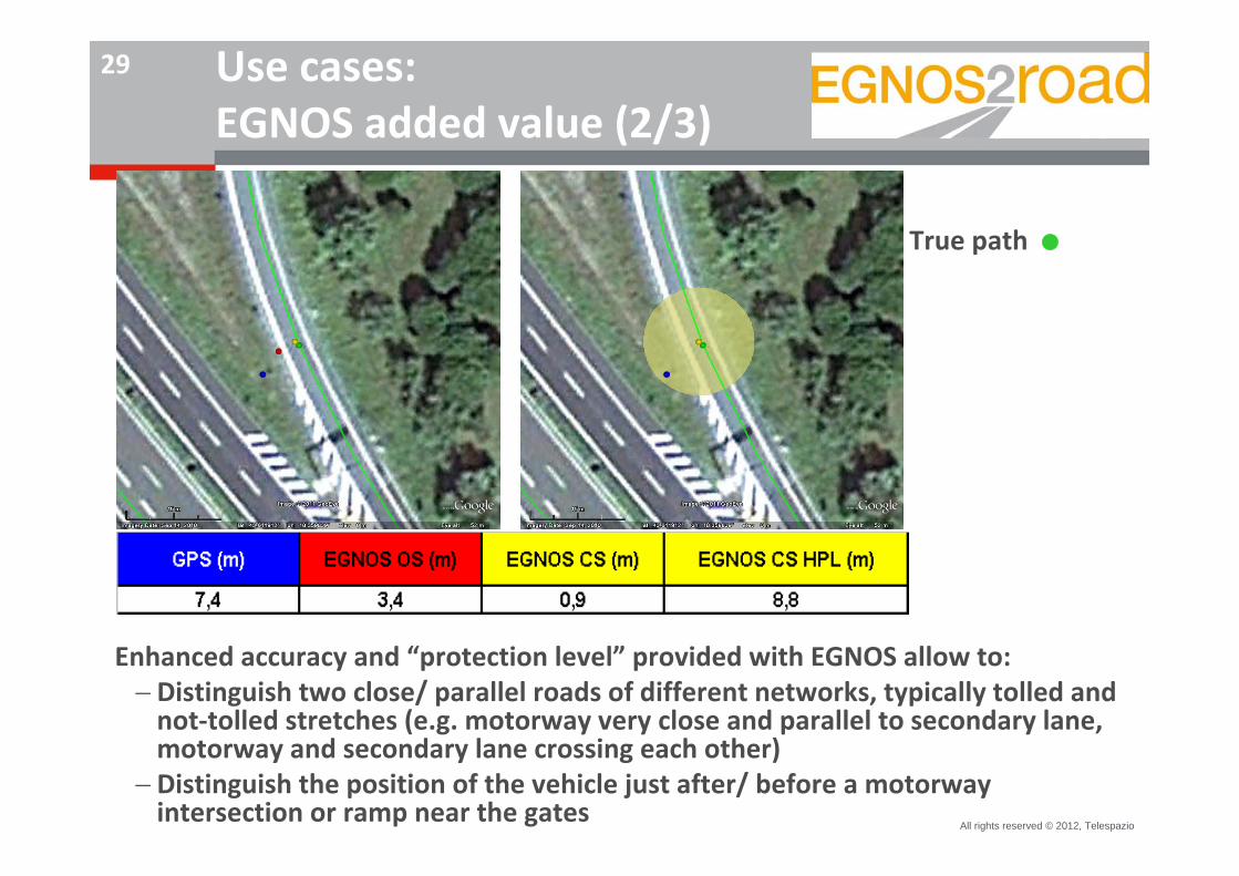
29 Use cases: EGNOS added value (2/3)
True path (
Enhanced accuracy and “protection level” provided with EGNOS allow to:Distinguish two close/ parallel roads of different networks, typically tolled and not‐tolled stretches (e.g. motorway very close and parallel to secondary lane, motorway and secondary lane crossing each other)
Distinguish the position of the vehicle just after/ before a motorway intersection or ramp near the gates
All rights reserved © 2012, Telespazio
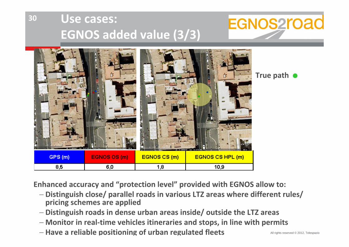
30 Use cases: EGNOS added value (3/3)
True path (
Enhanced accuracy and “protection level” provided with EGNOS allow to:Distinguish close/ parallel roads in various LTZ areas where different rules/ pricing schemes are applied
Distinguish roads in dense urban areas inside/ outside the LTZ areasMonitor in real‐time vehicles itineraries and stops, in line with permitsHave a reliable positioning of urban regulated fleets
All rights reserved © 2012, Telespazio
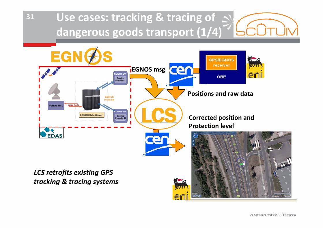
31 Use cases: tracking & tracing of dangerous goods transport (1/4)
Value‐AddedService Provider
EGNOS msg
Positions and raw data
Corrected position and Protection level
LCS retrofits existing GPS tracking & tracing systems
All rights reserved © 2012, Telespazio
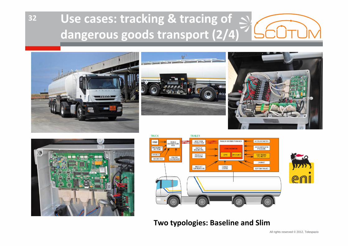
32 Use cases: tracking & tracing of dangerous goods transport (2/4)
Two typologies: Baseline and Slim
All rights reserved © 2012, Telespazio
33 Use cases: tracking & tracing of dangerous goods transport (3/4)
EGNOS OS and EGNOS CS (through LCS) used in an operational business case by
eni, a worldwide Italian oil & energy company
Remote monitoring of tankers transporting hydrocarbon and chemical materials:
Today about 300 vehicles, in Italy, France, Austria, Slovakia, Hungary, Romania,
and Czech Republic
By the end of 2012, extending to vehicles in Germany and in Switzerland and to
the transport of aviation material
Technical standard CEN Workshop Agreement CWA 16390:2012 publicly
available
All rights reserved © 2012, Telespazio
34
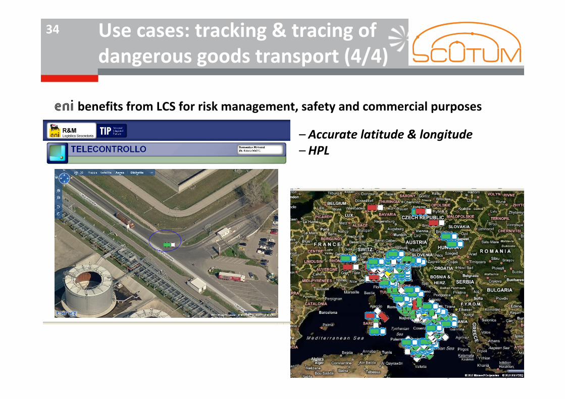
eni benefits from LCS for risk management, safety and commercial purposes
– Accurate latitude & longitude– HPL
Use cases: tracking & tracing of dangerous goods transport (4/4)
All rights reserved © 2012, Telespazio
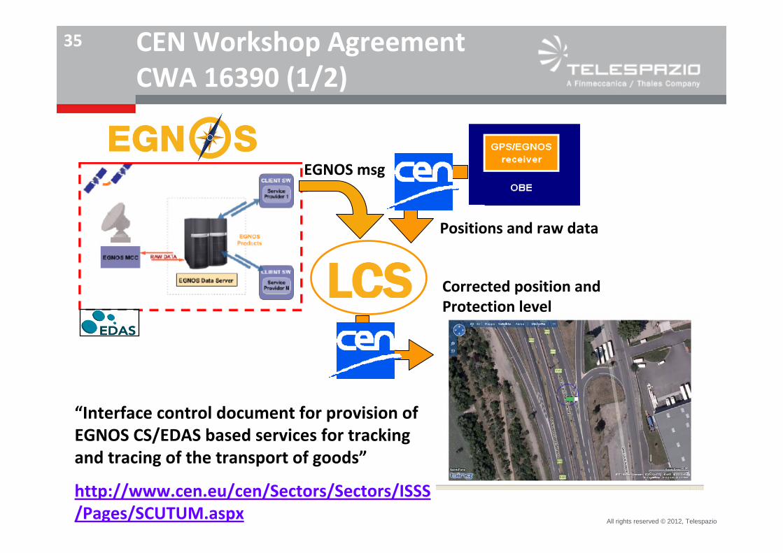
35 CEN Workshop AgreementCWA 16390 (1/2)
Value‐AddedService Provider
EGNOS msg
Positions and raw data
Corrected position and Protection level
“Interface control document for provision of EGNOS CS/EDAS based services for tracking and tracing of the transport of goods”
http://www.cen.eu/cen/Sectors/Sectors/ISSS/Pages/SCUTUM.aspx

All rights reserved © 2012, Telespazio
36
EU technical specification
Endorsed by EU stakeholders from industries, institutions and research sector
Enabling the development of products and applications based on the EGNOS CS/EDAS
Compliant with the guidelines of the UNECE/OTIF WG on telematics for dangerous goods
Applicable to Intelligent Transport Systems (ITS/CALM) and mobility applications(DATEXII and 3GPP/OMA)
CEN Workshop AgreementCWA 16390 (2/2)
All rights reserved © 2012, Telespazio
37
Outlook and perspectives–Exploitation in other land transport markets/applications, e.g.:
Freight multimodality (e.g. container transport)
Rail
–Extending European best practices and use cases in Europe’s adjacent regions (e.g. area around the Mediterranean basin, as long EGNOS service extension is being implemented).
–Research for multi‐constellation environment, Galileo at first. in particular in the future when Galileo satellites can be used in conjunction with GPS, for achieving higher satellite availability in all environments, and thus possibly higher performances.
–Research on use/added value of future Galileo authentication

All rights reserved © 2012, Telespazio
38
Thank you
Questions ?
Contacts:Antonella Di [email protected]