Embed Size (px)
Citation preview

EG1106 - GI: A Primer
Exploitation of GI and Remote Sensing for Warfare & Intelligence
18th March 2005

Topics
Structure of the intelligence servicesCold War era uses of GIModern uses of GI in warfareModern uses of GI in intelligenceGI and war crimesIraq conflict

Structure of the Intelligence Services
UK In telligence Services
Security Service(M I5)
H o m e O fficeF B I in U S
Secret Intelligence Service(S IS /M I6)
F o re ig n O fficeC IA in US
GCHQF o re ig n O ffice
N S A in US
Joint Intelligence Comm ittee(J IC )
C a b in e t O ff ice

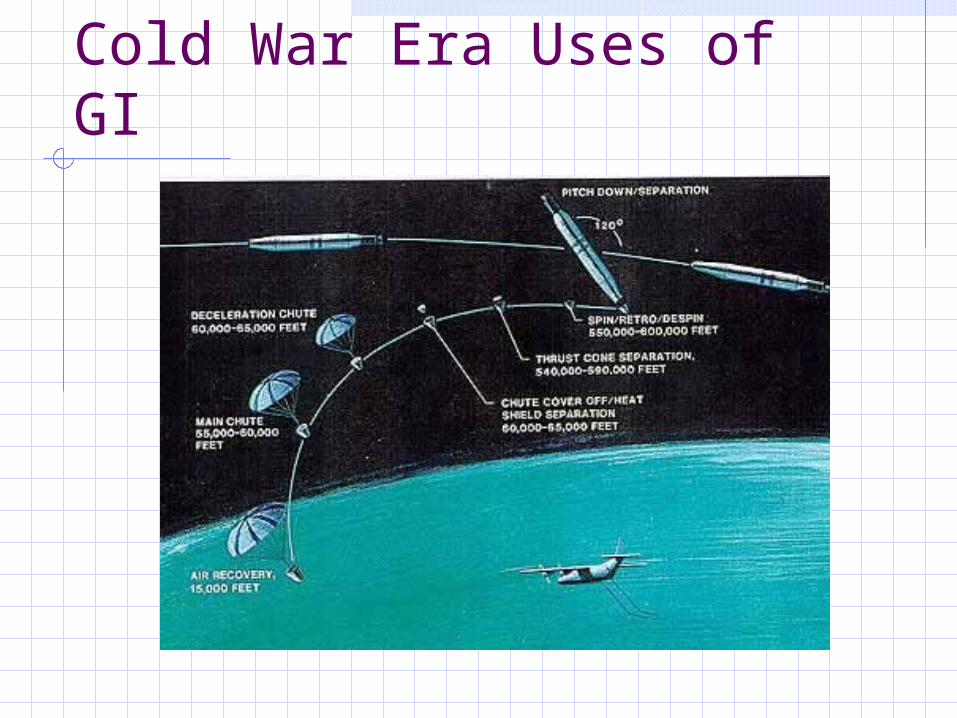
Cold War Era Uses of GI
Ever since post-war tension between the Soviet Union and the West increased, rocket technology (pioneered by the Nazis) has been used for spyingHigh altitude aircraft as well as early polar orbiting satellites have been used for surveillance activities.

Cuban Missile Crisis
Sagua La Grande MRBM Site 1 - 23 Oct 62

Cold War Era Uses of GI
In order to facilitate their surveillance capabilities, the US introduced the CORONA spy satellite system – after the programme was approved by Eisenhower in 1958The original incarnation would take photographs (of the Soviet Bloc countries) from space and then re-orbit the canned film for processing

Cold War Era Uses of GI
Cold War Era Uses of GI

Cold War Era Uses of GI
Dolon Air Field, USSR - Selected heavy bombers compared with selected transport aircraft 20 Aug 1966
Image from Corona satellite

Cold War Era Uses of GI
The CORONA satellite system became operational in 1959 and different versions were introduced until it reached the end of its life in 1972 - having mapped 750 million square miles of mostly USSR and China.Details relating to the system were declassified and made public by a presidential order from Clinton in 1995Other satellites were tested in parallel with CORONA, such as Discoverer - but many of the launches were failures and a number of mice placed on board sadly perished!

Modern uses of GI in warfare
Modern battle situations make much use of GI and remote sensing technologyArtillery, personnel, tanks, ships, planes etc are all georeferenced by GPS equipment relayed to central command HQ via encoded signals
Modern uses of GI in warfare
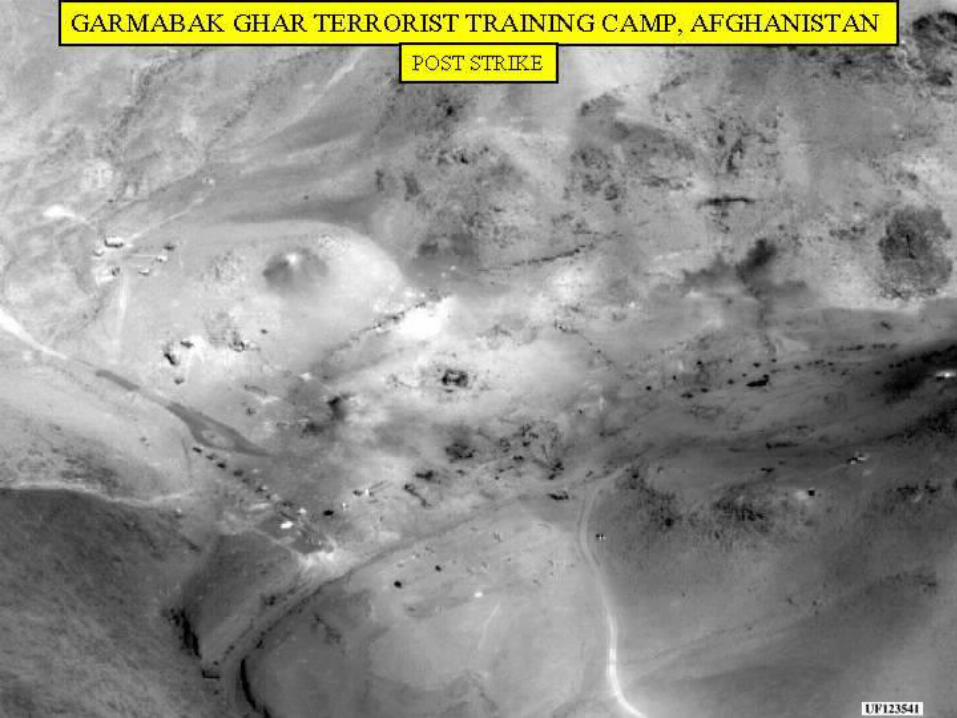
High resolution satellites can view enemy locations (personnel, tanks, ships and artillery) making their destruction by “smart laser guided weapons” more efficientMost front-line troops have access to computers with digital maps - regularly updated by comms links

satellite
enemy allies
commandHQ
laser guider


Area-51
Image from Ikonos1m resolution
Modern uses of GI in intelligence
Human Intelligence (HumInt), Signals Intelligence (SigInt) and other sources of information are spatially referenced and combined within a GIS at SIS/CIA headquartersNumbers, distances and strike capabilities are assessed and strategic plans devised

Modern uses of GI in intelligence
Field agents (foreign intelligence) and “watchers” (security services) may often be provided with GPS equipment for target referencing and acquisition
UK intelligence were “caught out” a few years ago when their carefully concealed devices were found in a Sinn Fein staff car in Northern Ireland
GI and war crimes
GIS has become an indespensible tool in the gathering and analysing of evidence for war crimes - particularly in the Balkans conflictProject Kosovo is a Rule of Law Through Technology initiative sponsored by the Illinois Institute of Technology and the Chicago-Kent School of Law

GI and war crimes
The Project Kosovo team created a database application, the War Crimes Documentation Database, that records and analyses war crimes data gathered from different human rights organisations in the Balkans and may be used in future areas of conflict

Refugee “evidence” data - spatially and temporally referenced


Aerial photosrecord effectsof conflict onvillages in theBalkans

Landsat images show effects of conflict in Balkans
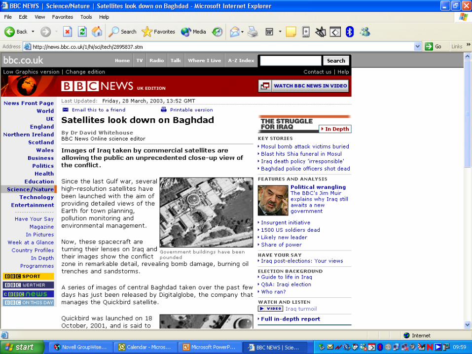

Post-strike assessment of Southern Fallujah

BaghdadPresidentialPalaces