Embed Size (px)
Citation preview

Efficient Cadastral Survey Methodology In Natural Disaster region
- Case study in Korea -
BongBae, JANG Republic of Korea
27th of Sep. 2018 Bergen Norway


Contents
1. Overview
2. Establishing Disaster Investigation Methodology
3. Case Study 1 and 2
4. Conclusion

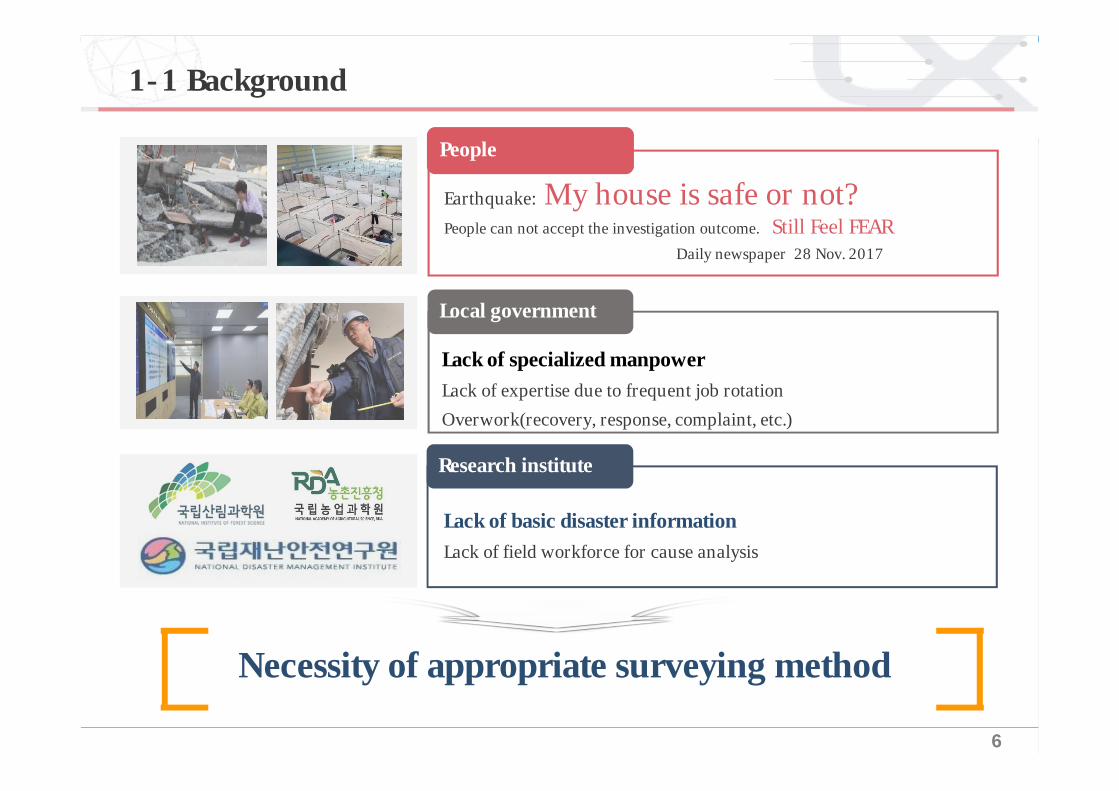
1-1 Background
1-2 Objective
1-3 Key issues
Overview01
6
Necessity of appropriate surveying method
1-1 Background
Earthquake: My house is safe or not?People can not accept the investigation outcome. Still Feel FEAR
Daily newspaper 28 Nov. 2017
Lack of specialized manpowerLack of expertise due to frequent job rotationOverwork(recovery, response, complaint, etc.)
People
Local government
Lack of basic disaster informationLack of field workforce for cause analysis
Research institute

7
1-2 Objective
Identify appropriate cadastral surveying method for monitoring national
disaster damage
Main topic
Objective
Review of disaster cadastral survey methodology
1
Case Studies2Identification of best solution3
National Disaster

8
1-3 Key Issues
Person in chargeIdentify requirements
8 week
6 week
4 week
3 week
1 week
Identify optimal surveying
•『Framework Act on Disaster Safety』Reform Act
Time-series data collection
National Assembly
Discussion(collaboration)
visitation safety depart.
case study 1(Landslide)
case study 2(Earthquake)
•(MMS/UAV)•The latest technology

2-1 Selection of Disaster Types
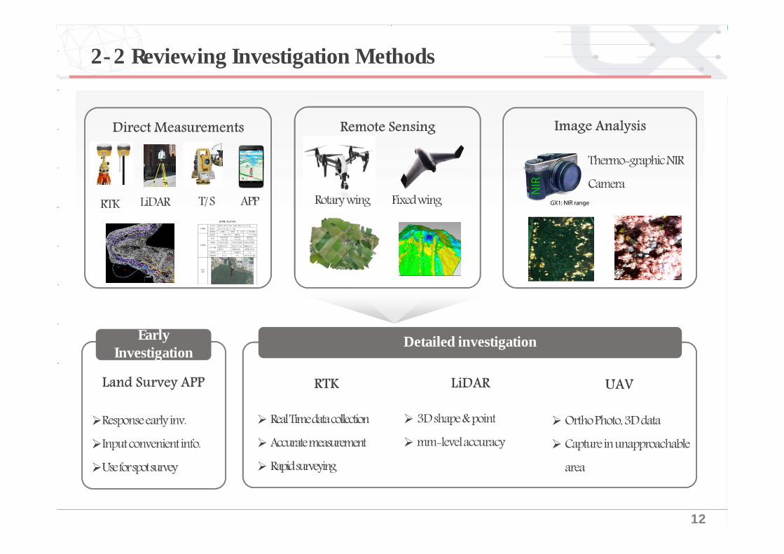
2-2 Reviewing Investigation Methods
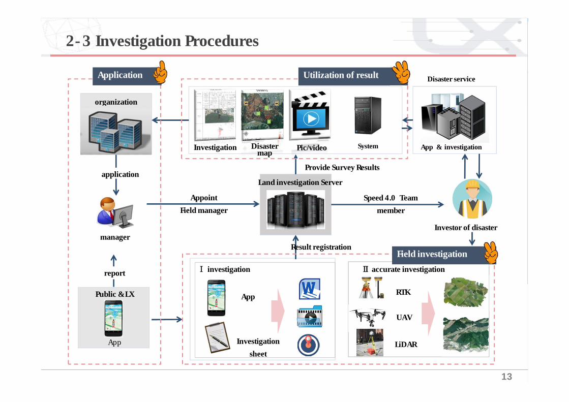
2-3 Investigation Procedures
02 Establishing Disaster Investigation Methodology
10
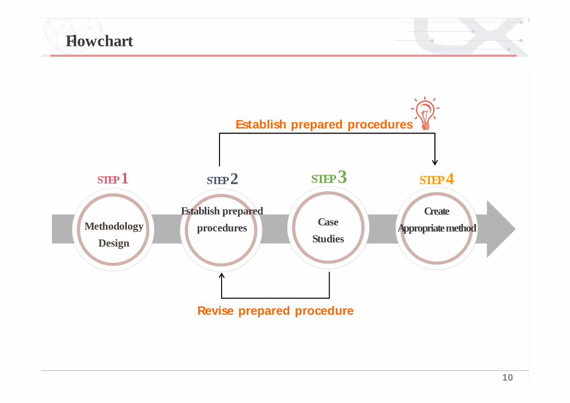
재해조사방법론정립흐름도
방법론구상
Revise prepared procedure
Establish prepared procedures
STEP 1Methodology
Design
STEP 1Establish prepared
procedures
STEP 2
Case Studies
STEP 3Create
Appropriate method
STEP 4
Flowchart

11
Needs for disaster Investigation?
Where is the demand?
Apply for spatial
Information technology?
2-1 조사유형선정
Forest Fire / HailstoneLandslide / Earthquake
2-1 Selection of Disaster Types
Selection of Standard for Disaster Type
12
1-1 배경및필요성2-2 Reviewing Investigation Methods
Early Investigation Detailed investigation
13
1-1 배경및필요성2-3 Investigation Procedures
Disaster map Investigation Pic/video System
Land investigation Server
organization
Ⅰ investigation
UAV
AppPublic & LX
App
manager
Appoint Field manager
application
report
Provide Survey Results
Result registration
Investor of disaster
Speed 4.0 Team member
App & investigation
Disaster serviceUtilization of resultApplication
Field investigation
Investigation sheet
RTK
LiDAR
Ⅱ accurate investigation
3-1 Type & Scope3-2 Case Studies
Case1. LandslideCase2. Earthquake
Case Study03

15
1-1 배경및필요성3-1 Type & Scope of Case Studies
Type of case studies17.05.06. Gangueng
Hail17.09.19. Choongju
Earthquake17.11.15. Pohang
Mountain landslide17.07.16. Choongju
Forest fire
16
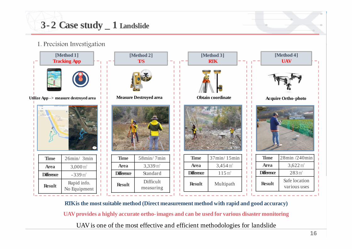
[Method 2]T/S
[Method 3]RTK
[Method 4]UAV
[Method 1] Tracking App
Utilize App -> measure destroyed area Obtain coordinate Acquire Ortho-photoMeasure Destroyed area
Time 26min/ 3minArea 3,000㎡
Difference -339㎡
Result Rapid info.No Equipment
Time 58min/ 7minArea 3,339㎡
Difference Standard
Result Difficultmeasuring
Time 37min/ 15minArea 3,454㎡
Difference 115㎡
Result Multipath
Time 28min /240minArea 3,622㎡
Difference 283㎡
Result Safe locationvarious uses
RTK is the most suitable method (Direct measurement method with rapid and good accuracy) UAV provides a highly accurate ortho-images and can be used for various disaster monitoring
UAV is one of the most effective and efficient methodologies for landslide
3-2 Case study _ 1 Landslide
17
1-1 배경및필요성
````````1
지번별피해현황지번 면적(㎡) 소유자 지번 면적(㎡) 소유자산36-1 3622 최**
87 334 최**
188-4 479 조**
187 64 국유지188 129 시유지
263-38 193 국유지
264 32 김**263-39 307 국유지
363-39 307 국유지
위치도 산사태피해현황
발생일시 2017.07.16.촬영일시 2017.11.02.
피해면적(㎡)
유실 : 1984 / 758매몰 : 1638 / 4208전체 : 3622 / 4966
범례
유실면적
지적선
등고선
매몰면적
① Attribute data
지번별피해현황
지번 면적(㎡) 소유자 지번 면적(㎡) 소유자산36-1 3622 최**
87 334 최**
188-4 479 조**
187 64 국유지188 129 시유지
263-38 193 국유지
264 32 김**263-39 307 국유지
363-39 307 국유지
산사태피해현황
발생일시 2017.07.16.
촬영일시 2017.11.02.
피해면적(㎡)
유실 : 1984 / 758
매몰 : 1638 / 4208
전체 : 3622 / 4966
§ Orthphoto, 3D Image, Video, DATA of destroyed areas
② Application§ Report to VIP § Data Upload in Real-Time§ Masterplan for Damage
reduction
§ Certification for damaged level
<Landslide Information System>
<산사태흔적도정보>
3-2 Case study _ 1 Landslide

18
1-1 배경및필요성
①
②
③
① InterviewField Investigation
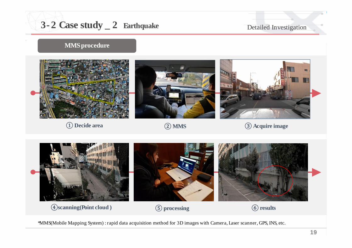
Pre-investigation3-2 Case study _ 2 Earthquake
19
1-1 배경및필요성 Detailed Investigation
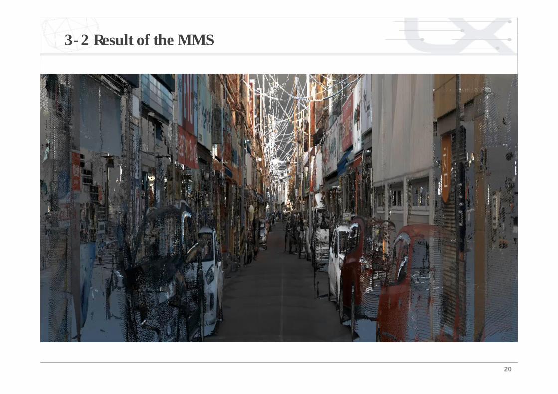
*MMS(Mobile Mapping System) : rapid data acquisition method for 3D images with Camera, Laser scanner, GPS, INS, etc.
MMS procedure
① Decide area ②MMS ③ Acquire image
④scanning(Point cloud ) ⑤ processing ⑥ results
3-2 Case study _ 2 Earthquake
20
3-2 Result of the MMS

21
1-1 배경및필요성3-2 Case study-2. earthquake
UAV survey procedure
① Planning ② GCP surveying ③ Data collection(flying)
④ Digital Elevation Modeling ⑤ processing ⑥ results
Detailed Investigation
22
1-1 배경및필요성
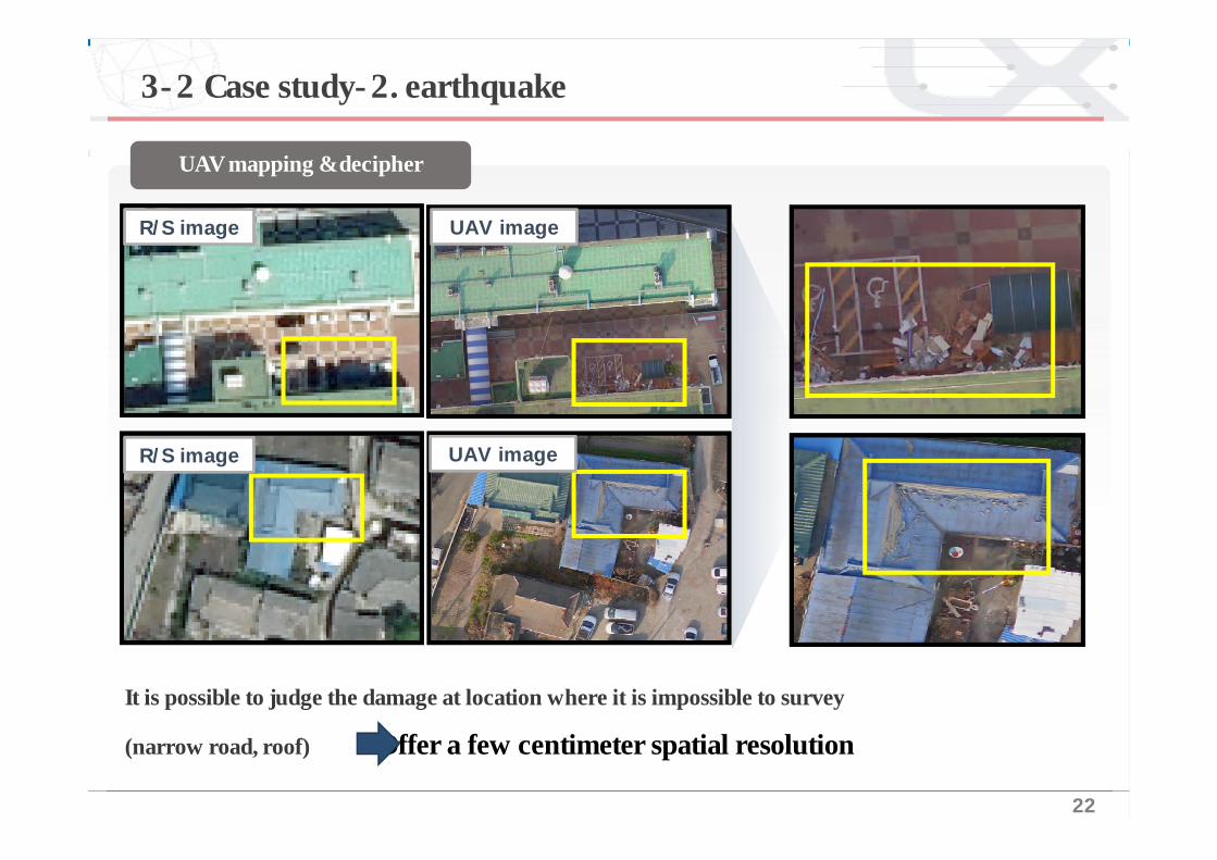
It is possible to judge the damage at location where it is impossible to survey
(narrow road, roof) Offer a few centimeter spatial resolution
R/S image UAV image
UAV mapping & decipher
R/S image UAV image
3-2 Case study-2. earthquake

23
1-1 배경및필요성
범례
2등급
3등급
4등급
5등급
1등급
MMS(slope, well crack, damage) + UAV(well damage, roof damage) classification about building damage
Building damage classification
3-2 Case study-2. earthquake

24
1-1 배경및필요성
범례
2등급
3등급
4등급
5등급
1등급
Building damage analysis
MMS(slope, well crack, damage) + UAV(well damage, roof damage) classification about building damage
3-2 Case study-2. earthquake

25
1-1 배경및필요성Building damage analysis
3-2 Case study-2. earthquake

26
1-1 배경및필요성
Application
Merit Demerit
1. Securing Safety of investors
2. Obtaining data of
roof of building
1. Taking time for flight
admission
2. Difficulty in getting side
view
Through a Variety of censors, Through a Variety of censors,
people rescue and estimate for damaged areas
Application
Merit Demerit
1. Rapid Acquisition of
data by using vehicle
2. Acquisition of
Precise data
1. Have to employ
vehicles
2. Diff iculty in
obtaining data of
roof of building
Precise maps through automatous vehicle
Safety inspector for roads and tunnels
3-3 Implication
UAVMMS

Conclusion04
28
4-1 Conclusion
National disaster damage investigation system was designed.The most appropriate surveying method was identified by two case studies.
For the landslide disaster four different methods were compared andanalyzed.(APP, TS, RTK, UAV)
UAV is the fastest and safest method
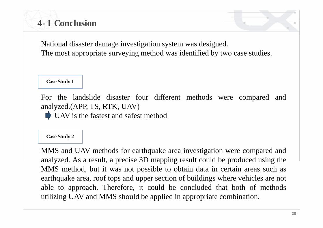
MMS and UAV methods for earthquake area investigation were compared andanalyzed. As a result, a precise 3D mapping result could be produced using theMMS method, but it was not possible to obtain data in certain areas such asearthquake area, roof tops and upper section of buildings where vehicles are notable to approach. Therefore, it could be concluded that both of methodsutilizing UAV and MMS should be applied in appropriate combination.
Case Study 1
Case Study 2