Embed Size (px)
Citation preview

THE WORLD BANK
POLICY PLANNING AND RESEARCH STAFF
Infrastructure and Urban Development Department
Report INU 17
Efficiency in Land Use and Infrastructure Design
An Application of the Bertaud Model
byAlain Bertaud Marie-A
8 nes Bertaud
James . Wright, Jr.
May 1988
Discussion Paper
This is a document published informally by the World Bank. The views and interpretations herein are those of the author and should not be attributed to the World Bank, to its affiliated organizations, or to any Individual acting on their behalf.
http://alainbertaud.com

Cop right 1988 The LJ orld Bank 1818 H Street, N.W.
All Ri hts Reserved First nnting May 1988 8.
This is a document published informally by the World Bank. In order that the information contained in it can be presented with the least possible delay, the typescript has not been prepared in accordance with the procedures appropriate to formal printed texts, and the World Bank accepts no responsibility for errors.
The World Bank does not accept responsibility for the views expressed herein, which are those of the author and should not be attributed to the World Bank or to its affiliated or and conclusions are the results of research supported by the Bank; they %
anizations. The findings, interpretations, o not necessarily represent offrcral pokey
of the Bank. The designations employed, the presentation of material, and any maps used n thus document are solely for the convenience of the reader and do not imply the expressron of any opinion whatsoever on the part of the World Bank or its affiliates concerning the legal status of any country, territory, city, area, or of its authorities, or concerning the delimitations of its boundaries or national affiliation.
The authors are Alain Bertaud from the Asia Technical Department, Infrastructure Division, James Wright from the EMENA Technical Depanment, Infrastructure Division and Marie-Agnes Bertaud, who worked as a consultant. This report was prepared under a World Bank research project RPO-872-81) which was managed by
b the South Asia Urban Projects Division. The authors gratefully acknowledge t e support of Sven Sandstrom to this work and the advice given by Stephen Mayo (INURD).

The World Ehnk
Efficiency in Land Use and Infrastructure Design
An Application of the Bertaud Model
Discussion Paper

ABSTRACT
There is an increasing awareness throughout the developing world of the importance of improving the efficiency of urban land use. The search for more efficient land use must be pursued at two different levels. First, it is necessary to review the impact of land use regulations on development costs and to devise a more affordable mix of regulations without reducing the quality of the urban environment. Second, it is necessary to pursue opportunities for greater efficiency at the project design level.
With a wide range of alternatives to choose from, planners can make much informed decisions in determining appropriate least cost solutions. But cost reduction alone is not enough for successful design. It is also necessary to maximize the satisfaction created in projects and to price developed plots appropriately. Each design option is associated not only with a particular cost but also with a specific level of satisfaction for project beneficiaries. Several examples are given of how various.aspects of projects can be designed more efficiently by using modelling techniques to cost a range of alternatives and then using knowledge of local market conditions to choose the most appropriate low cost/high value solution.
The concept of value and costs are basic to the design process, and the interaction of cost and value needs to be considered carefully when using modelling techniques. These concepts and their relations to the design process are discussed and methods are suggested for assessing the value of land development projects. Several examples are given of specific project characteristics which could be designed more efficiently with a more thorough analysis of cost and value. Finally the authors take a critical look at the traditional site planning process and suggest how the type of analysis illustrated in the paper can be brought into a new planning process which would take advantage of the new modelling techniques.

- iii -
EFFICIEMX IIJ LAND USE AND IIWRASTRUCTURE DESIGN
AN APPLICATION OF THE BERTAUD MODEL
Table of Contents
I. INTRODUCTION ............................................
II. THE VALUE AND COST OF DEVELOPED LAND ....................
A. Value of Developed Land ............................. B. The Cost of Developed Land ..........................
(1) Establishing Affordability ..................... (2) Variations in Cost as Design Changes ...........
c. Variations in Cost and Value ........................
III. TEE IMPACT OF DESIGN ALTERNATIVES ON COST AND VALUE .....
A. Plot Frontage Variations ............................ B. Variations in Block Length .......................... c. Variations in Road Width ............................ D. Variations in Infrastructure Standards ..............
IV. DIFFERENTIAL LAND PRICING ...............................
A. Accurate Plot Costing ............................... B. Creating Value Through Careful Planning for
Differential Land Pricing ......................... c. Pricing and Location of Commercial and Public
Space ............................................. (1) Location and Dimension of Residential and
and Commercial Plots ......................... (2) Location of Public Facilities ..................
v. THE PREPARATION OF LAND DEVELOPMENT SCHEMES--PROCESS AND WORK SEQUENCE . . . . . . . . . . . . . . . . . . . . . . . . . . . . . . . . . . . . . . .
A. The Model Used for Urban Land and Infrastructure Pricing, Costing and Design . . . . . . . . . . . . . . . . . . . . . . .
B. A Proposed Revised Work Sequence for Land Development Schemes . . . . . . . . . . . . . . . . . . . . . . . . . . . . . . .
ANNEXES
ANNEX 1: Detailed Example of Proposed Work Sequence . . . . . ANNEX 2: The Affordability of Land Subdivision
Legislation - Uttar Pradesh Case Study........
Page No.
1
4
4 * 9
9 10 10
13
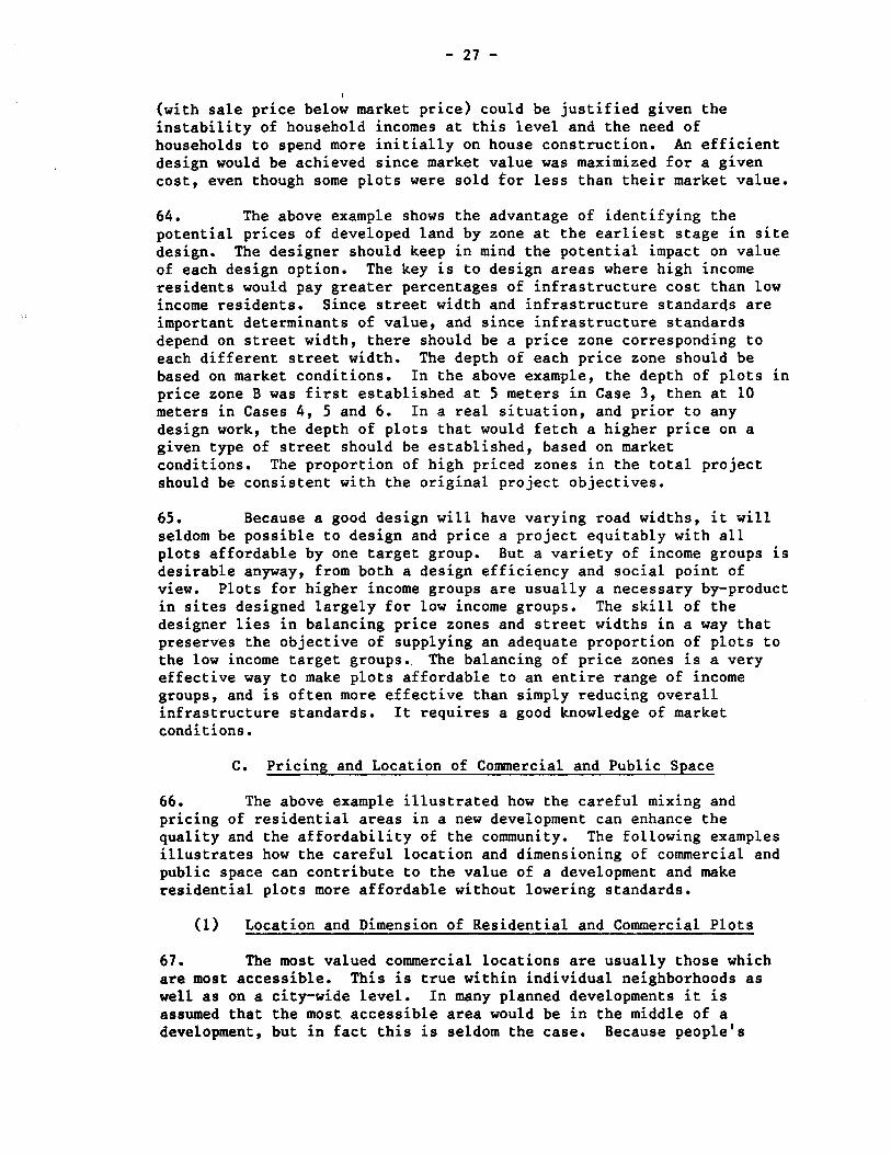
14 17 17 17
20
20
23
27
27 28
31
32
33
43
68

- iv -
Page No.
FIGURES
FIGURE 11.1:
FIGURE 11.2:
FIGURE 11.3:
FIGURE 11.4:
FIGURE 111.1:
FIGURE 111.2:
FIGURE 111.3:
FIGURE IV.l:
FIGURE IV.2:
FIGURE IV.3:
FIGURE V.l:
TABLES
TABLE III-l:
TABLE 111-2:
TABLE IV-l:
TABLE IV-2:
TABLE V-l:
TABLE V-2: TABLE V-3:
Relationship Between Rents and Location Market Rent Curve ............................. Relationship Between Plot Value, Location and Infrastructure Standards ...................... Variations in Average Infrastructure Cost When Number of Plots Increases ..................... Variations in Infrastructure Cost and Plot Value When Number of Plots Increases .......... Variations in Infrastructure Cost and Plot Value When Plot Frontage Increases ............ Infrastructure Cost and Block Length Variations .................................... Variation in Infrastructure Cost When Street Width Increases ............................... Average Development Cost and Development Cost Per Zone ................. ..i .................. Differential Land Pricing and Design Efficiency .................................... Variations in Design Efficiency for Alternative Community Facilities Locations ................ Design Sequence Phase 2 and 3 .................
Development Cost and Design Efficiency When Plot Frontage Varies . . . . . . . . . . . . . . . . . . . . . . . . . . Development Cost When Access Street Width Varies . . . . . . . . . . . . . . . . . . . . . . . . . . . . . . . . . . . . . . . . Development Cost, Price and Landuse Correspond- ing to the 6 Cases Presented in Figure IV.3 . . . Changes in Design Efficiency for Alternative Locations of Community Facilities . . . . . . . . . . . . . Data Required as Input in the Affordability Submodel . . ..e................................. Affordability Model Worksheet . . . . . . . . . . . . . . . . . Aggregated Infrastructure Unit Costs . . . . . . . . . .
5
a
11
12
15
18
19
22
24
29 38
16
17
25
30
34 36 40
NOTE: Cost data in this paper for illustrative purposes is based on stylized Indian cost information from 1983, converted to U.S. dollars unless indicated otherwise.

AN APPLICATION OF THE BERTAUD MODEL
I. INTRODUCTION
Background
1. There is an increasing awareness throughout the developing world of the importance of improving the efficiency of land use in development projects. Since 1950, the urban population of the third world has grown from less than 300 million to 1,250 million. If urban growth continues at this level, and there is every indication that it will, large amounts of newly urbanized land will be necessary to accommodate the new urban population. However, with the types of' development standards typically required in most low cost land development projects, it is doubtful that enough new land can be developed legally to accommodate the growing urban population.
2. Land is becoming increasingly scarce, so it is clearly important to find ways of economizing on land where possible, especially if this can be done without reducing the quality of the urban environment. More efficient land use would reduce not only the direct cost of land in projects but also the cost of providing and maintaining urban infrastructure. In the long run, it will also increase the supply of developed plots, thus reducing the upward pressure on urban land prices. This research has indicated that there is, in fact, much scope for improving the efficiency of urban land use in most countries. The type of analysis suggested in this paper could help to reduce land use requirements in typical projects by as much as 30 percent, a substantial savings.
3. The nature of the problem and the potential solution are better understood by analyzing the impact of present land use practices in individual projects. Such an analysis has been undertaken as part of this research for the state of Uttar Pradesh in India (see Annex 2). It was found that 87 percent of the urban households in the state would not be able to afford the minimum sized plot in a land development which meets all the land development and municipal engineering regulations. Most projects which meet the minimum standards can only be afforded by low income households if there are large capital and interest subsidies. But government agencies have only limited budgets for subsidized development, which limits the scope of such programs.
4. Because present development standards are unaffordable both to f individual households and to government agencies, it is not surprising that large numbers of new urban dwellers are settling in illegal developments and in illegally occupied squatter settlements. Indeed, the slum populations of many third world cities are growing faster than the general population, leaving large numbers of the urban population in unplanned and poorly serviced communities. It is, therefore, extremely important to seek ways of reducing the cost of new development.

-2-
5. An analysis of typical projects in many third world countries has shown that the costs of new development can be significantly reduced by using land more efficiently. Road and open space typically account for up to 60 percent of project area, which is far more than can be justified by vehicular traffic and recreational needs and cannot be fully utilized or maintained by the community. With a combination of improved land use (with only about 30 percent road and open space) and differential land pricing (whereby a mix of plot types is provided and higher prices are charged for the better located plots), plots can be made affordable to most low income households without subsidies. By being careful not to reduce the standards which are most valued by low income-households, this can usually be done without lowering the quality of the urban environment.
6. The search for more efficient land use must be pursued at two different levels. First, it is necessary to address regulatory authorities (urban planning department, development agencies, municipalities, etc.) to assess the combined cost of existing regulations and to devise a more affordable mix of regulations. Second, it is necessary to pursue opportunities for greater efficiency at the project design level. In both cases, this has frequently not been done in the past due to the lack of adequate tools for analyzing the cost of existing practices and for formulating more practical alternatives.
7. New tools now exist to facilitate the analysis of alternative standards and designs. A two-part model has been developed for this analysis for use with microcomputers. It is based on the accounting relationships between the basic parameters of urban design, including aspects of land use and infrastructure design. Earlier work had developed a first part of the model (the Bertaud Model), referred to here as the “Affordability and Differential Land Pricing Sub-Model.” The second part of the model, developed under a research project and called the “Detailed Land Use and Infrastructure Costing and Design Sub-Model ,” is discussed in Chapter V.
8. Assessing the cost implications of site designs used to be very time consuming, but by using a model the implications of a large number of design alternatives can be quickly determined. Its use in analyzing the appropriateness of regulations at the state level is described in Annex 2. This paper illustrates the use of a model in the pricing, costing and design of land development projects and it describes how new modelling techniques can be introduced into the planning process. This paper is, therefore, primarily addressed to planners and engineers at the project level who can use the type of model described in this report to make improved design decisions.
The Pricing, Costing and Design of Urban Projects
9. Many designs characteristics can be considered in land development such as the amount of open space, plot sizes, type of clustering, type of sanitation, type of street surfacing and engineering specifications. In the traditional design process, specifications for most of these design characteristics had to be taken as given. Only a few variations in design could be planned and costed within the time constraints of a normal project preparation period. There was also

-3-
little assessment of alternative pricing patterns for projects. Now, using the model, it is possible to analyze quickly the implications of a large number of design variations, involving even relatively minor design characteristics, and a number of pricing patterns.
10. With a wide range of design alternatives to choose from, planners can make much informed decisions in determining appropriate least cost solutions. But cost reduction alone is not enough for successful design. It is also necessary to maximize the satisfaction created in projects and to price developed plots appropriately. Each design option is associated not only with a particular cost but also with a specific level of satisfaction for project beneficiaries. mere are many examples of development projects which achieved low cost in a way which was unacceptable to beneficiaries. For example, in one project in Central America, the intended beneficiaries of a low-cost project showed little interest in purchasing plots. The project had relatively high infrastructure standards (roads, water supply, sanitation, etc) but small plots. The intended beneficiaries actually would have preferred larger plots with lower infrastructure standards. For a similar price, they were purchasing a much larger plots developed at a lower standard in a nearby unlicensed development. Designers must, therefore, be sure that they are creating designs with high value to beneficiaries as well as low cost.
11. The new modelling techniques give planners and engineers the freedom to choose from among a wide range of options. However, they do not replace the planners' and engineers' judgement. The information about design alternatives provided by a model must be combined with knowledge of local market conditions in order to choose designs which provide a maximum value for beneficiaries for a minimum cost. Several examples are given in this report of how various aspects of projects can be designed more efficiently by using modelling techniques to cost a range of alternatives and then using knowledge of local market conditions to choose the most appropriate low cost/high value solution. In some cases the differences may appear to have little significance. But when all the potential design and pricing improvements are considered together. Cost reductions and value enhancements could be quite significant. The analysis of many projects has shown that, if all potential design and pricing improvements are taken into account, the price of plots to low-income beneficiaries could be reduced by an average of about 50 percent without reducing the quality of environment provided.
12. The concepts of value and cost are basic to the design process, and the interaction of cost and value needs to be considered carefully when using modelling techniques. These concepts and their relation to the deign process are discussed in Chapter II, and methods are suggested for assessing the value of development projects. An illustration is given of the interaction of value and cost as design changes and of how knowledge of this interaction can be used to plan efficient projects. In Chapter III, several examples are given of specific project characteristics which could be designed more efficiently with a more thorough analysis of cost and value. Chapter IV takes a wider perspective and shows how entire sites can be planned and priced more efficiently based on an improved analysis of options for the

-4-
costing and pricing of land for residential, commercial and public use. Chapter V looks at the traditional planning process and suggests how the types of analysis illustrated in Chapters III and IV can be brought into a new planning process which would take advantage of the new modelling techniques.
II. THE VALUE AND COST OF DEVELOPED LAND
13. The value of a site design, as perceived by beneficiaries, is dependent on the design characteristics, as are the development costs. But high development costs do not necessarily lead to high value. 'It is therefore important to evaluate separately design factors as they influence value and as they affect the cost of development.
A. Value of Developed Land
14. The value of plots of land to beneficiaries depends on how they perceive the benefits and disbenefits that come with ownership of the plot. The benefits can usually be assigned to one of three categories: (a) convenience; (b) future income; and (c) social status.
(a) Convenience benefits. Plot size, plot frontage, the quality of infrastructure and social amenities, accessibility, and availability of public transportation are the major factors that will determine a potential user's evaluation of a plot's convenience benefits;
(b) Income benefits. The value of a plot will be enhanced if future income can be derived from the plot, for example, whether the plot can be used as the location of a shop, a large commercial building, workshop, or whether it can be rented to tenants. These benefits depend on both design factors and land use regulations;
(c) Social status benefits. Housing is usually perceived not only as shelter but as a symbol of social status. The location of housing can have a connotation that will increase or decrease its value, regardless of convenience or future income benefits. And within a given site, design can enhance or diminish status benefits. A group of large and well maintained plots that is accessible only by passing through a lower income settlement will have a much lower value than its other benefits would justify.
15. One way to assess the value of different site characteristics is to assess the rents that individuals would be willing to pay for them. Consider, for example, Figure II.1 which illustrates the relationship of rents which individuals would be willing to bid for similar .plots in different locations (sometimes called 'bid-rents'). A commercial establishment would be willing to pay relatively high rents for more convenient locations because of the income that could be

FIGURE II.1 -5-
RELATIONSHIP BETWEEN RENTS AND LOCATION MARKET RENT CURVE
Commercial Establishments
Rent Curve
Low Income Households
Convenient location Remote location

-6-
derived and it would have little interest in remote locations. A lower income household would be willing to pay less rent even for convenient locations, but they would be willing to pay low rent for locations not demanded by others. If similar bid-rent functions were drawn for all firms and households, it would be possible to trace a market curve indicating rents which would be bid by firms and households for similar plots at different locations.
16. In many situation market rents are the best available indicators of the value which potential beneficiaries would place on design characteristics. In other cases, market price data may be . available and may provide a better indicator of value. (Prices may be a better indication of value where there is a large economic benefit in home ownership). Although governments make many attempts to control rents and prices of land and housing, there are often enough market signals available to planners to judge the value people would assign to various design characteristics, especially since large segments of housing and rental markets often are informal, outside the effective control of governments.
17. Although market rents or prices usually provide the best available indicator of the value beneficiaries would place on design characteristics, it is sometimes necessary to adjust market information for factors which may not be fully reflected, such as safety, long-term maintenance costs and the need to protect the environment. The value of amenities such as clean air and groundwater or reduced maintenance costs to local government may not always be reflected in the rents which beneficiaries would be willing to pay. However, these types of factors must be considered very cautiously and not introduced in a way which would diminish the satisfaction to beneficiaries or make development unaffordable.
18. Empirical methods have been developed for determining the market value of various attributes of developed land and housing such as plot size, access, provision of utilities, sanitary facilities and density. This involves detailed household and business surveys to assess how the provision of these types of
91 rvices would affect the
market price of developed land and housing.-
19. Planners can often use their own knowledge of local market conditions to estimate the relative values of plots (in terms of rents or prices individuals and firms would be willing to pay). A simple illustration shows how the relative values of six plots can be estimated
11 James Follain and Emmanuel Jimenez, Estimating the Demand for Housing Characteristics: A Survey and Critique, World Bank Report No. UDO-42, October, 1983.
Follain and Jimenez, The Demand for Housing Characteristics in Developing Countries, World Bank Report No. UDO-43, October, 1983.

-7-
by simply looking at their locations, infrastructure standards and proportions (see Figure 11.2). Plot A, located at the intersection of two major roads, has high potential value for commerce. Plots B and C are both located on a major road, and both have the same area, but B has a wider frontage (12.5 meters) than C (10 meters). It will be possible to build a detached house on B, whereas it will only be possible to construct a semi-detached house on C. Plot B is, therefore, likely to have a higher value. Plot E will have a higher value than D (but less than A, B, or C) because it too is located at the intersection of two streets and has a slightly higher commercial potential, even though the two plots are the same size. Plot F, located on a narrow pedestrian cul de sac, will have the lowest value of the six plots. It has little potential commercial value, it has the least advantageous infrastructure (i.e. no vehicular access), and the design of any building for the plot will be constrained by its narrowness.
20. Value ranking as illustrated above would, of course, have to be based on a knowledge of local preferences. There are no universally applicable rules for determining value. Narrow plots, for example, are sometimes acceptable to upper income groups in societies where there is a tradition of urban row housing, as in Amsterdam or Bangkok. But a narrow plot might not be acceptable even to low income groups in countries where there is a strong tradition of patio-type houses, as in North Africa or West Asia. It is therefore essential for the planner to have a good understanding of local preferences before designing a new community.
21. When detailed market studies are not available, it is possible to examine price data for housing which has been bought or sold. From a limited sample of such data, planners can extrapolate a more complete set of market prices by using premium or discount coefficients to reflect variations in location, plot size, plot shape, infrastructure, and social facilities. Unfortunately, however, market price data may not be accurate (for example, due to under declaration of sales prices to avoid taxes), and it may only be available for upper and middle incomes groups where transactions are registered.
22. In situations where detailed market data are not available, two types of surveys can be considered to improve the planners' knowledge of the value beneficiaries would place on certain design characteristics:
(a) Physical Observation of the Housing Stock of the Target Croup. This type of survey will consist of (i) locating sample groups of housing occupied by a specified target group: (ii) selecting representative households for case studies; (iii) measuring and recording key features of the plot, the house, the street and nearby open space; (iv) inferring from these observations some priorities and minimum requirements for community planning (such as minimum acceptable plot sizes, infrastructure needs, usefulness of open space, etc.); and, (v) if possible, relating household expenditures to the physical features observed.
(b) Target Household Demand Surveys. This type of survey'requires

-8- FIGURE II.2
RELATIONSHIP BETWEEN PLOT VALUE. LOCATION AND INFRASTRUCTURE STANDARDS

-9-
more time and more qualified enumerators than a survey of physical features. Target group households are asked their preferences among design options and the trade-offs they would make between several key layout and infrastructure characteristics within the household budget constraint. This gives direct insight into the value that households would place on key design characteristics.
B. The Cost of Developed Land
23. It is important to understand the relative values which . households attach to various design options since maximizing value is a key objectives in planning a site development. However, since we are concerned with accommodating a full range of social groups and since government does not have the resources to subsidize development projects at the required large scale, our objective needs to be further defined: to maximize the value created for the specified target groups within a cost which is affordable.
24. It is possible to establish an overall affordable cost within which a project must be planned. But many different layouts could be designed for the same cost. It is important, therefore, to analyze the cost of each design characteristics and the trade-offs between characteristics within the overall cost constraint. By having a range of affordable designs to choose from, planners can strive to choose the design with the greatest value.
(1) Establishing Affordability
25. It is first necessary to establish the amounts that households in the designated target groups would be able to pay for the types of development that we are likely to provide. In some cases, household budget survey data may be available to indicate household incomes, the percentages of incomes available for monthly housing payments and the amounts affordable as down payments. In other cases it may be necessary to observe local rental markets to determine the amounts of rent paid by each group. In both cases these amounts are likely to have to be adjusted since currently observed payments by the largest group are for land and housing, and only developed land will be provided in the design. However, in many cases households may be willing to increase their monthly payments and down payments over current levels if they have the opportunity for ownership and if they would have improved levels of services.
26. If affordable downpayments and monthly payments are known, it is possible to calculate the total amount that can be spent per household. This is done by capitalizing the affordable monthly payment using the market interest rate. Since our objective is affordability, it is important to use a market interest rate so that the cost target thus calculated would be affordable without recourse to scarce subsidized financing.

- 10 -
(2) Variations in Cost as Design Changes
27. Since savings on one design characteristics can be used to enhance others within the affordable cost constraint, it is important to know how cost would vary with changes in the main design characteristics. The amount of variation in cost depends on complex interrelationships with other design characteristics and will be different in each case.
28. To illustrate, Figure II.3 shows a block of 8 plots of 180 square meters each (called A plots), accessible by 12 meter streets on both sides of the block. The cost of roads, drainage and sidEwalks is $10.51 per gross square meter and $7.25 per net square meter.-/ Let us
. add four 90 square meter plots (B plots) served by a street 6 meters wide between the 180 square meter plots (Layout 2, Figure 11.3). We then continue adding 90 square meter plots (Layouts 3 and 4) up to 40 plots. The average cost per net square meter varies as the number of 90 square meter plots increases. It increases sharply when only a few 90 square meter plots are added ; it then decreases progressively as the number of 90 square meter plots grows to 40 at which point it reaches only $3.75 per net square meter.
29. The average cost per net square meter of 180 square meter plots remains constant (Figure 11.41, since their number does not change. The variation of the average cost of development is due to the addition of 90 square meter plots. If only two 90 square meter plots are provided, their average cost per net square meter is nearly three times that of the 180 square meter plots, due to the large amount of additional roads and infrastructure required to service only two plots. However, as the number of 90 square meter plots increases and the additional cost of roads and infrastructure can be spread over a large number of plots, the average cost per net square meter decreases rapidly.
30. This example demonstrates the importance of sensitivity analysis order to understand how costs vary as design changes. Even though the smaller plots have a lower infrastructure standard, the average cost of development actually rises if only a few of them are introduced into the design. The average cost is reduced as more plots are added, but the cost savings are much more significant for the first twenty plots than for the second twenty.
c. Variations in Cost and Value
31. The amount of satisfaction created in a design--its value--is not necessarily linked to the cost. For example, in Figure 11.3, Layout 1, the cost of producing plots B is more than twice that of plots A, but the plots B would have a lower market value since they are smaller, less
Al The cost per net square meter refers to the cost of saleable land after roads and other non-saleable land have been subtracted from the project area,

1
LAYO
UT
1 VA
RIA
TIO
NS I
N A
VER
AGE IN
FRAS
TRU
CTU
RE CO
ST W
HEN
NU
MBE
R OF
PLO
TS IN
CR
EASE
S
0 “8
”=31
.03%
C
IRC
.
LAYO
UT
2
4 “8
”~36
.40%
C
IRC
.
LAYO
UT
3
20"8
"=28
.24%
C
IRC
.
LAYO
UT
4
Num
ber o
f 8
plot
s g :
40"8
"-23
.62%
C
IRC
.
--- _
_ _
H”
. w

LAYO
UT
1 VA
RIA
TIO
NS
IN
INFR
ASTR
UC
TUR
E CO
ST A
ND
PLO
T VA
LUE
GgT
WH
EN N
UM
BER
OF
PLO
TS I
NC
REA
SES
y::::
z$
:::>;
.A
....
:::<:
:::
:::s:
:::
fg:y
ij$
$$
:::::s
:: :::
::::::
:::
$#
:.:.:.
:* 0
“B”=
31.0
3%
CIR
C.
LAYO
UT
2 ii
..*
_..I...
_. .:.:
.:::j
%:::I
:: ::::
::j::
:::::::.
:, ;:$
$g
:::::$$
: ::::
::::::
p:$$
::::
::z
:.:.::.:
. :$y
:: ::::
::::;
::::::::
:: :.:.
:.:.*
4 “B
”=36
. 40
% C
IRC
.
LAYO
UT
3
20”8
”=28
.24%
C
I RC
.
LAYO
UT
4
40”8
”=23
.62%
C
I RC
.
2 26
k 24
22
20
18
16
14
12
10 8 6 4 2 l-l
rf aJ
N
ul
4
.--I
e cz
i-t
F;
: i+
i s
Valu
e of
pl
ots
B -.-
.-.-m
m
lnfra
etru
cture
co
st of
pl
ots
B N
umbe
r of
B pl
ots
------
---
lnfro
struc
ture
m
et
of
plot
s A
. . . .
. . . .
. . . .
. . . .
. . . .
. . . .
. . . .
. .
Aver
age
Infro
etru
cture
Co
at

- 13 -
accessible and have a lower standard of infrastructure. Figure II.4 illustrates how the value of plots B is likely to vary as their number increases. When the number of plots ranges from 2 to 16, the market value (measured as the price beneficiaries would be willing to pay net square meter) would not vary greatly, since within their range additional plots would not create large benefits or disbenefits to individual plot holders. But when the number of plots increases beyond 16 the average market value of plots would decrease, and it would decrease sharply if the number of plots were increased beyond 32.
32. 'When the number of plots is small, the street serving the plots would have a semi-private character. But if the number of plots were increased, the narrowness of the street would give a feeling of overcrowding, and the average value of plots would decrease. This decrease in value is logical, but the exact profile of the curve reflects individual tastes and cultural factors, and it would be likely to differ somewhat among societies.
33. Let us now consider average cost and average value together. In Figure II.4 we note that average price of plots B is greater than their average cost if the number of B plots is between 10 and 38. The difference is greatest between 20 and 28 plots. An efficient design would be in this range where the difference between satisfaction (value) and cost is maximized.
34. In a typical design process , planners have to consider the relationships of value and cost for a number of design characteristics. The above type of sensitivity analysis can help to improve design efficiency, especially when it is focused on the main design characteristics which account for large percentages of total cost and on those of which cost and value are very sensitive to changes in design.
35. In the extreme case, a process could be envisioned which would measure the sensitivity of cost and value to all the design options in a proposed development and optimize them simultaneously to create the greatest possible value within an affordable constraint. However, this would be mathematically complex, and it is unlikely that sufficient data would be available. Such a complex methodology would generally not be practical and is not recommended. However, many designs could be improved if planners analyzed more systematically the sensitivity of cost and value to some of the main design options and integrated this knowledge into the normal planning process. Several examples of this type of sensitivity analysis are given in the following section.
III. THE IMPACT OF DESIGN ALTERNATIVES ON COST AND VALUE
36. This section discusses the effects on cost and market value of changes in key design characteristics: plot frontage, block length, street width and infrastructure standards. The object is not to demonstrate "correct" design solutions. The most desirable solution will usually be different from case to case. However, these examples show the importance of careful analysis of design options.

- 14 -
A. Plot Frontage Variations
37. Let us design a block 60 m long which contains plots that are 35 meters square (see Figure 111.1). Also assume that access to the block is by a street 6 m wide, and that the streets at each end of the block are 8 meters wide. We will then measure the cost per square meter as plot frontage varies from 2.75 m to 5.25 m, with plot area staying constant. Line 34 of Table III-1 shows the variations in cost per net square meter for eleven different plot frontage sixes. The increase in cost as the plot frontage increases is due in part to an increase in the quantity of materials used, but the largest part of the increase is due to a change in the percentage of street area (line 12 of Table III-l).
38. Let us now estimate the prices that households would be willing to pay for plots of different widths. These prices will be an indicator of the degree of satisfaction or value that the household expects to derive from the plots. The households’ degree of satisfaction would largely depend on the degree to which house design would be constrained by the plot shape. If plots were only 2.75 m wide, for example9 the rooms would have to be extremely narrow, and although two rooms could be built, none could have separate access. It would be difficult even to provide space for a staircase to enable vertical expansion. Thus, the narrowness of the plots would give them a low value.
39. If the plots were 4.25 m wide, it would be possible to build two rooms with independent access on the ground floor, and there would still be enough space for a staircase. Thus, this shape plot would provide greater user satisfaction. But if plots were still wider, say 5 m wide, satisfaction would diminish. The wider plots would not be deep enough to build two full rooms on the ground floor.
40. Cost and value are plotted as functions of frontage in Graph 1 of Figure 111.1. In this case, greater efficiency (difference between cost and value) is reached when plot frontage is between 3.35 m and 4.85 m. An indicator of efficiency can be derived by calculating the difference between value and cost of each option as a percentage of cost (see line 38 of Table III-1 and Graph 2 of Figure 111.1). Coefficients calculated in this way indicate that a plot frontage of about 4.10 m would be most efficient. It is important to note that in this case the cheapest solution is not the most efficient, and that the most expensive i solution does not necessarily mean a higher degree of user satisfaction.
41. The two graphs in Figure III.1 are, of course, case-specific. Therefore, no general rule can be deduced from them as to the most efficient plot frontage in all cases. If the plot area were increased from 35 to 45 square meters, both the cost and value curves would have different profiles and the most efficient frontage would also be different.

VAR
IATI
ON
S IN
IN
FRAS
TRU
CTU
RE
CO
ST A
ND
PLO
T VA
LUE
WH
EN PL
OT
FRO
NTA
GE
INC
REA
SES
Plot
Am 3
5 I2
Plot
hnta
ge : 2
.75 I
Plot
htal
y :
3.50
I
Plot
Frm
taJe
: 1.
25 I
Plot
htay
e:
5.00
~
30 25
20
15
10
5 0
z 8 -5
z
-10
-15
:: H
-20
/ \
. P _
-25
/ / -%
El
Kl
R
kc
Es
K.
l w
K!
8
x: D
esig
n effic
ienc
y
d o-
5 cl
3 03
0-
S i
a?
a?
a:
vi
vi

- 16 -
TMLE III-! -DEVELOPtfENl COST AND DESIGN EFFICIENCY WHEN PLOT FRONTAGE VMIES -_--_--------------_____________________--------------------------------------------------- 4 5 b 7 8 9 10 11 12 13 14 15 lb 17 18 19 20 21 22 23 24 25 26 27 28 29 so 31 32 33 34 33 36 37 39
PLOT WIDTH 2.75 3.00 3,ZS 3.50 3,75 4.00 4.25 4.50 4875 3.00 ----_--------__-________________________-------------------------------------------- Plot area 3s 35 35 35 3s 35 35 3s 3s 3s __________-___---__--------------------------------------------------------------- Plot lcnqth 12.73 11.67 10.77 10.00 9.33 0.75 8.24 7.70 7.37 7.00 ____-________-__________________________------------------------------------------ Hodulc area 1887.2 1760 1652.3 !SbO 1480 1410 1348 1293 1244 1200 _-_--____-____-_-_______________________----------------~--------------------------- X Circulation 29,8b 31.06 32.22 33.33 34.41 35.41 36.48 37.46 38.41 39.33
-----------------------------------------------------------------------------~- Cost of Roads 3509 3384 3277 3187 3109 3040 2979 2926 2877 2834
Water 2954 2791 2669 2599 2286 2252 2183 2259 2218 2177 SMU 2729 2581 2468 2412 2464 2423 2340 2104 2070 2036
______-_______--________________________---------------------------------------- Total cost 9192 0756 8414 8198 7859 7715 7502 7289 7165 7047 ___-___---_____--_-___________________u_-------------------------------------- Cost /gross e2 4,87 4.98 5.09 5.26 3.31 5.47 5.57 5.64 5.76 5.87 ___--____-__-___---_____________________------------------------------------------- Cost/net r2 6.94 7.22 7.51 7.88 8.10 8.47 8.76 9.01 9.35 9.68 8888888888888888888888~888888888u88n88888888888888888888888888888888u88u88u8888
Land cost/r2 2 ____-____-_________--------------------------------------------------------------- Off rite c/12 .S -----__-_-_----_----------------~-------------------------------------------------- Phyrmntinq. 8 Z Desiqr Supav. 12 z Interest dmn 9 Z ---___----------------------------------------------------------------------------- TOTAL DEVELOP. COSTI8ROSSH2~ 9.2611 9.3986 9.5532 9.7679 9.8403 10.053 10.177 10.272 10.433 10.582 IWET HZ a 13.204 13.633 14.094 14,651 15,003 13.565 16,021 16.424 16.940 17,442
8888888888888888888888888888888n88n8888888888888888888888888888n88888888888888888
PRICE /NET HP= 4,OO 9.00 13.00 lb.00 18.25 19.50 20.00 19.50 18.25 lb,00 _-____-_-_-___--_-______________________-------------------------------------------- DESIBW EFFIC,Z -69,7! -33,98 -7,77 9,21 21.64 25,20 24,83 l&73 7,74 -8.27 ----I)-------------------------------------------------------------------------------

- 17 -
B. Variations in Block Length
42. Variations in block length can have an important impact on cost. Generally there are economies in road space and infrastructure which reduce average development costs as blocks are lengthened. However, as shown in Figure 111.2, the amount of cost savings will vary depending on the type of pattern used.
43. As pattern A is lengthened, there are especially from 40 to 60 meters, large savings in average development costs. Pattern B is more efficient to begin with because it has less circulation space (peripheral roads are narrower although a courtyard is created in the middle). Lengthening pattern B reduces average cost only slightly.
44. This example illustrates the importance of careful analysis. Rules of thumb about block length and other design characteristics are of limited use because each case is unique.
c. Variations in Road Width
45. An analysis of variations in road width is shown in Figure 111.3. Plots of 60 and 65 square meters are grouped along a loop road connected to an 18 m wide road. The plots facing the 18 m road are 85 square meters. The loop road is 4 m wide in the first option, 6 m wide in the second, and 8 m wide in the third. The development cost per square meter and the percentage of circulation corresponding to each option are shown in Table 111.2. Doubling the width of the loop road increases the cost of development per net square meter by about 20 percent. The market value of the 85 square meter plots would probably not change, since they do not benefit directly from a widening of the loop road. Although the additional open space of a wider road may contribute some value to the 60 and 65 square meter plots, this would probably be limited, since occupants of the plots would not own cars. Increases in average plot values would be unlikely to offset cost increases in the second two options. Thus, the first option would be the most efficient.
Table III.2: DEVELOPMENT COST WHEN ACCESS STREET WIDTH VARIES
Street width in meters 4.00 6.00 8.00 Development Cost/Gross M2 7.90 8.20 8.42 X of Circulation Area 21.50 26.24 30.55 Development Cost/Net M2 10.07 11.12 12.13
D. Variations in Infrastructure Standards
46. In the preceding examples we measured the effects of layout changes on cost and value; infrastructure standards were held constant.

--
--
--
--
-I
-
_-
.-
-
.-
--
--
-_
_-
--
-
--
_-
-
--
--
--
-
-_
--
--
--
.-
-_
-
__
.-
-.
_.
--
--
--
-
-.
-
-
.-
-.
-
-.
--
-
__. -.
_.
__
INFR
AS
TRU
CTU
RE
CO
ST
AN
D B
LOC
K L
EN
GTH
VAR
IATI
ONS
‘HH’
Ji
ill3.
11
10 9 8 7 6
‘Elllm
’ ‘H
I1I’
‘HI’
.HIII
H.
.FT1
1[71
H. .m
* l -
* .-•
80
m
__- .
-_..
- ..-
.._
- --.-.
----.-
- --.
-- --
----
--
--
. -.
-.-,
----N
\ ---
- ---
--;-.
----a
-\ -=
=---~
‘~
- ---
-_-..
--___
--
Bloc
k A
\
.'-,.
-1
---a,
-_
--mm
+
Bloc
k B
I E
iii Bl
ock
leng
th
Cm
>

FIGURE III.3
i % e
6 2
P

- 20 -
Similar sensitivity analysis can be useful holding layouts constant and varying infrastructure standards. Some infrastructure standards affect both cost and value--for example, type of road surfacing--but many variations in standards which are not directly visible may have little effect on market price although they have a large impact on cost. For example, cost can be reduced by underdesigning the storm drainage system without initially affecting market price. In these cases, designers should adjust values to allow for long term benefits or disbenefits which may not be reflected in market prices or rents.
IV. DIFFERENTIAL LAND PRICING
47. In the previous sections we have seen how the average cost and value of plots can be varied by changing individual design characteristics. The examples shown thus far involved relatively small sites with only a few plot types. In large developments, there is an opportunity to provide a much wider mix of plot types, including residential plots for a range of income groups as well as plots for small-scale commercial and industrial use. Larger developments give planners the opportunity both to create a socially mixed community and to vary the pricing of plots to make the development more affordable to the lowest income groups.
48. Plots have traditionally been assigned prices based on the average cost per square meter of developing an entire project site. Larger plots cost more, but the cost per square meter did not vary, even though some plots were better and benefited from higher standard infrastructure than others. Thus, a first step that planners can take towards more equitable pricing is to calculate the costs of the different areas in project sites more accurately. But we have seen that cost and value are not necessarily the same. Thus, some areas of a site may have a higher market value than they cost to create, and they can be used to generate a surplus to lower the price of other areas.
49. This assignment of differential prices should not be seen as the final act of the planning process. In fact, if planners recognize in advance the potential different values in a site, they can exploit areas with high potential value for the benefit of residents. This latter point is especially important and deserves some emphasis, since it is frequently overlooked in practice.
A. Accurate Plot Costing
50. In most land development schemes, development characteristics will not be uniform throughout the entire site. Some streets will be wider than others, the various individual plots will have different sixes and different proportions, and infrastructure standards will differ from one plot to another. A land development scheme can be compared to several different types of products manufactured in the same factory. One way of determining the production cost per unit would be by dividing the total cost of production by the number of units

- 21 -
produced. But this average production cost, although arithmetically correct, would not be very useful, since it does not indicate the different costs of different types of units. For this reasons, different methods of cost analysis are preferable in assessing land development. One of these is the calculation of spot development cost, which is the cost of development in a specific area.
51. Figure IV.1 shows a simple layout with four types of plot accessible from four types of streets. One way of evaluating the development cost per square meter would be to divide the total cost of development by the total area. However, since roads, open space and some community space cannot be sold, it is more useful to divide by the amount of saleable land to calculate the net development cost per square meter. The average net development cost fat a site can give a general indication of overall development costs, but it is of limited use for pricing plots, since the costs of producing different types of plots will obviously be different. The average cost will be less than the actual cost of producing the most costly type of plot and more than the actual cost of the least costly type. Thus pricing using average cost can result in an internal cross subsidy benefiting beneficiaries of the highest standard plots at the expense of beneficiaries with lower levels of service.
52. Planners usually try to design progressive cross subsidies into projects to benefits low income groups. However, it is difficult to do so when the production costs of each plot type are not known. To illustrate, the two layouts in Figure IV.1 are identical, but in the second layout plots with similar characteristics have been grouped into four separate zones. Circulation space (streets and footpaths) accounts for 26.6 percent of the entire site, but this percentage varies widely among zones. It is 41.4 percent in Zone 1 but only 12.5 percent in Zone 4. Assuming a typical set of unit costs, the average cost of development per net square meter varies from $7.33 in Zone 1 to $1.91 in Zone 4. A typical pricing system based on insufficient cost information might price plots in Zone 1 at $6.00 per net square meter and plots in Zone 4 at $3.50 per net square meter in an effort to benefit low income groups. However, this would actually result in a regressive cross sudsidy from Zone 4 to the larger and better serviced plots in Zone 1.
53. It can be complicated to disaggregate development costs into uniform zones. To simplify the process, those costs which contribute to the benefit of particular zones can be separated from those which do not and therefore should be averaged. For example, sidewalks in Zones 1 and 2 contribute to their enhanced value and should be added to the spot development costs of those zones. But a water tower located in Zone 3 would not result in a benefit only to that zone and its cost should be averaged over the whole site (assuming that water consumption will be uniform throughout the site).

AVER
AGE
DEVE
LOPM
ENT
COST
AN
D DE
VELO
PMEN
T CO
ST
PER
ZONE
Aver
age
Deve
lopm
ent
cost
:
4.34
$/n
et
m2
Aver
age
Perc
enta
ge
of
circ
ulat
ion:
26
.57%
De
velo
pmen
t co
st,
Zone
1:
7.33
S/n
et
m2
Zone
2:
6.
93
” Zo
ne
3:
2.94
”
Zone
4:
1.
91
”
Perc
enta
ge
of
circ
ulat
ion,
Zo
ne 1
: Zo
ne
2:
Zone
3:
Zo
ne
4:
41.4
1%
33.6
1X
16.4
0X
12.5
0%

- 23 -
B. Creating Value Through Careful Planning for Differential Land Pricing
54. The above example showed how pricing can be made more equitable based on a more accurate analysis of cost after a project is developed. The following example will show how value can be created in the design of a site without incurring large additional costs. In this example, six alternative layouts have been prepared (see Figure IV.2). Table IV.1 summarizes the costs and pricing of each layout.
55. Let us assume that housing sites must be designed to accommodate households earning about $60 a month. Market surveys. indicate that these households would be willing to pay 12 percent of their income ($7.20 a month) for a plot of 50 m2 accessible through a street 4 m wide. Capitalized at a market interest rate, this means that they can pay a price per net square meter of developed land of $14.53.
56. Case 1 in Figure IV.2 is a theoretical layout where all the plots are alike with similar infrastructure standards and locational advantages. In this ca e, value: $14.53 per net m 1
all the plots would have the same market .
cost of development in case Assuming a typical set of unit costs, th$
1 can be calculated as $22.35 per net m (see line 4 in Table IV.1). Thus, there is a deficit between the development cost and the market value equivalent to 35 percent of total investment.
57. The same number of plots of the same size have been produced in case 2, but the plots have been grouped so that some are facing a 14 meter street while others face a 4 meter pedestrian street. In this case, development costs are slightly lower because the drainage network is shorter and because of reductions in street lengths (see Table IV.1). By introducing 14 meter streets, however, we have created a number of plots facing streets capable of carrying vehicular traffic. In Case 2, the difference in plot value is disrggarded and all purchases are assumed to pay the same price: $14.53 per m . The ratio of value to cost would improve slightly because a more efficient drainage system can be designed for the layout but the ratio is still negative, amounting to 21.35 percent of total investment.
58. In Case 3 the advantage of the higher value of plots facing 14 meter streets is taken into account, and two categories of plots are recognized: plots A facing 4 meter streets and plots B facing 14 meter streets. We assume that households with higher incomes than the original target of $21.80 per m2
group would be able to afford 37
higher price for plots B (see line 11 in Table IV.l).- The proportion of plots
A is 71 percent, of plots B 29 percent. Although plot B purchasers, whose income is estimated at $90 per month, are not part of the original target group, the high proportion of plots A would probably still make the revised plan consistent with project objectives. In spite of these improvements, cost would still be more than market value by 10 percent of total investment.
Y In an actual planning exercise this would be established through market surveys.

FIGURE IV.2
- 24 -
DIFFERENTIAL LAND PRICING AND DESIGN EFFICIENCY
CASE 1: Uniform standards.uniform pricea Deficit: 35%
CASE 42 Moximising surplus : 1%
HIQIER PRICE
mmn UIrIIIli CASE 31 Varying ahmdmb, voryjng prlcea deflclt 10%
t- ; !
CASE 5: Incrwsing surplusr 8%
CASE 81 Adjuetment surplus: 15%
higher priced a-eos
area with lower standard6
of star&u-de ond prices i

- 25 -
TABLE IV.1 -DEVELOPI(ENT COST, PRICE AND LAWDUSE CORRESPDNDINS TO THE 6 CASES PRESENTED ON FIGURE IV.3 --------------------____________________---------------------------------------------------------------------
CASEI CASEK! CASE)3 CASEH CASEIS ---_------------------------------
Cost of land & infra. 1 per gross a2 = 13.30 2 I of circulation = 40.48 3 Number of plots = 112
Cost of land t infta. 4 per net a2 = 22.35 --------------------------------
PLOT TYPE : A 5 % of type in layout= 100.00 6 honthly income = 60 7 X of inc.for plot = 12
Affordable monthly 0 payrent = 7.20
Total affordable 9 price /plot r 726.56 10 Plot size = SO.04 11 Sale price /m2 = 14.53 ,--------------------“------------- 12 RATIO PRICE/COST IX)= -34.99 I------------_---------------------
--e-- - - - - - - - - - - - - -
1
CASEl6 .----------------- I - - - - - - m - - - - - - - - - - - - - - - - - - - - - - - - - -
t
13.60 F----------------e
A Al 47.00 29.00 24.
60 60 12 12
11.00 11.00 11.00 10.39 40.40 40.48 40.40 31.00
112 112 112 136
18.48 18.48 18.40 15.08 -e-e-, ,-----------*- .------------_..--------------------
A A B A B A Al B 00.00 71.00 29.00 43.00 57.00 47.00 29.00 24.00
60 60 90 60 90 60 50 90 12 12’ 12 12 12 12 12 12
7.20 7.20 10.80 7.20 10.80 I
7.20 6.00 10.80
26.56 726.56 1089.9 726.56 1009.8 726.56 605.46 1089.8 50.00 50.00 5o.oa 50.00 50.00 50.00 42.24 50.00 14.53 14.53 21.60 14.53 21.81 14.53 14.33 21.80 -----..-------“----m ,-------------..--------------I---- 21.35 -10.11 1.13 7.93 --s-- ------------- i..------------ --------------------
The financial terms used for all plots are: 12% interest over 20 years, 10% down payment.
7.20 7.20 9.
126.56 726.56 96%. 50.00 50.64 50. 14.53 14.35 19.
------------------ 14.71
s----------------.
9.88 27.44
136
-1
- 26 -
s9. In Case 4 the B plots are arranged differently on the 14 meter roads, thus doubling their number and the area which could be marketed for a higher price. This would not affect development cost. In this layout, the market value of plots would exceed cost by about 1 percent. However, plots B would account for 57 percent of plots. Although Case 4 has a positive value/cost ratio, it is likely to be unacceptable, since the original target group would be a minority in the project. By trying to improve design efficiency, we have shifted the project toward a higher income group. *
60. In Case 5, two 14 meter streets are replaced by 4 meter streets, thus reducing the number of B plots.
I n doing
!I o, new A plots
are created but their area is reduced from SO m to 42 m (plots Al). This new sized plot is likely to be affordable to a slightly lower income group with a monthly income of $50. The elimination of the 14 meter street on bot
9 sides of the si e plan would lower infrastructure
cost from $11 per m to $10.39 per m 5 , and the street area would be oreduced to 31 percent of the total site from 40.5 percent in the other
layouts. In this case, value now exceeds cost by 7.9 percent, and 76 percent of the plots would be affordable to the original target group and the new slightly lower group (47 percent plots A; 29 percent of plots Al; 24 percent of plots B). However, although this site plan is largely affordable to target households, its design efficiency could be further improved.
61. In Case 6, the width of the axial street is reduced frqm 14 to 10.5 meters thus reducing infrastructure cost from $10.39 per m to $9.88 per m2 and street area from 31.08 percent to 27.44 percent (see Table IV.l). The value of B plots would be less, reflecting the reduced width of the axial
9 treet. The size of Al Jlots in this layout is
increased to SO.5 m , but their value per m would still be slightly lower than that of A plots because their frontage is 4.8 meters, compared to 5 meters for A plots. The ratio of price to cost would now be 14.71 percent. The proportion of A and Al plots in relation to B plots is satisfactory from the standpoint of public policy. All target group plots are meeting the affordability and market requirements established at the beginning of the planning exercise.
62. Thus, through relatively small design and pricing modifications, it is possible to improve the design efficiency ratio from minus 35 percent to plus 14.1 percent. These differences are not j insignificant. On a 50 hectare site a design similar to Case 2 would cost $0.5 million more than a Case 6 design and accommodate 1,300 plots less. The Case 2 design would lose about $1.2 million while the Case 6 design would generate a surplus of $2 million. Additional design and pricing options could also be contemplated--for example, increasing the amount of area devoted to plots B to give them a higher market value.
63. As mentioned, the last efficiency ratio in Table IV.1 indicates a surplus. It is up to policy makers to decide the best use of this surplus. It could be used, for example, to create a revolving fund to finance more projects, but it could also be used to reduce the price charged the lower’income target groups. This type of subsidy
- 27 -
(with sale price below market price) could be justified given the instability of household incomes at this level and the need of households to spend more initially on house construction. An efficient design would be achieved since market value was maximized for a given cost, even though some plots were sold for less than their market value.
64. The above example shows the advantage of identifying the potential prices of developed land by zone at the earliest stage in site design. The designer should keep in mind the potential impact on value of each design option. The key is to design areas where high income residents would pay greater percentages of infrastructure cost than low income residents. Since street width and infrastructure standards are important determinants of value, and since infrastructure standards depend on street width, there should be a price zone corresponding to each different street width. The depth of each price zone should be based on market conditions. In the above example, the depth of plots in price zone B was first established at 5 meters in Case 3, then at 10 meters in Cases 4, 5 and 6. In a real situation, and prior to any design work, the depth of plots that would fetch a higher price on a given type of street should be established, based on market conditions. The proportion of high priced zones in the total project should be consistent with the original project objectives.
65. Because a good design will have varying road widths, it will seldom be possible to design and price a project equitably with all plots affordable by one target group. But a variety of income groups is desirable anyway, from both a design efficiency and social point of view. Plots for higher income groups are usually a necessary by-product in sites designed largely for low income groups. The skill of the designer lies in balancing price zones and street widths in a way that preserves the objective of supplying an adequate proportion of plots to the low income target groups.. The balancing of price zones is a very effective way to make plots affordable to an entire range of income groups, and is often more effective than simply reducing overall infrastructure standards. It requires a good knowledge of market conditions.
C. Pricing and Location of Commercial and Public Space
66. The above example illustrated how the careful mixing and pricing of residential areas in a new development can enhance the quality and the affordability of the community. The following examples illustrates how the careful location and dimensioning of commercial and public space can contribute to the value of a development and make residential plots more affordable without lowering standards.
(1) Location and Dimension of Residential and Commercial Plots
67. The most valued commercial locations are usually those which are most accessible. This is true within individual neighborhoods as well as on a city-wide level. In many planned developments it is assumed that the most accessible area would be in the middle of a development, but in fact this is seldom the case. Because people's

- 28 -
normal daily movement takes them from inside residential areas towards peripheral main streets , people do not normally pass through the centers of their communities. Commercial facilities which are located there are typically underutilized. At the same time, Government feels obliged to prevent shops from springing up in other areas which are zoned for noncommercial use, and the potential value of these areas is lost.
68. Shopkeepers would often prefer to locate their shops at intersections, close to bus stops, and along roads with the greatest pedestrian and vehicle traffic, and they are willing to pay to do so. If these preferences are anticipated by planners, the potential value of well located sites can be exploited in the design and pricing of the ,development. For example, pedestrian movement can be concentrated along one or two streets in a development, thus increasing the commercial value of land along these streets. The value of commercial plots along these streets can be captured for the benefit of the target groups. Although it is frequently argued that commercial establishments should not be placed near roads and intersections with heavy traffic, it is possible to design facilities in order to minimize congestion (for example, by using service roads).
69. The size and dimensions of commercial plots are also important factors in determining their value. Different types of commercial activities require plots of different shapes and sizes. It is important to analyze the precise needs of small businesses prior to designing the space to accommodate them.
(29 Location of Public Facilities
70. Careful location of public facilities can also contribute to design efficiency. Parks and schools usually account for about 80 percent of public land in developments. Their requirements are different from those of commercial facilities. Parks and schools must be at a reasonable walking distance from the homes of the residents they serve, but unlike commercial facilities, they do not have to be located on the main pedestrian or vehicular streets of the community. Indeed, it is preferable to locate these facilities in areas where the value of land is lowest--i.e., away from areas most suitable for commerce and high income plots. In this way the value of well located land can be fully exploited and public land which must be paid for either by the residents or a government agency will have a low value.
71. The following example illustrates how a change in the location of community facilities can significantly improve design efficiency. Figure IV.3 shows two alternatives layouts: on layout 1, a park and a school have been located along a main road; on layout 2, the park and the school have been located along minor 5 m streets. Plot sizes and street standards are the same for both layouts. Table IV.2 shows the difference in design efficiency for the two layouts assuming a typical set of unit costs and plot prices. The cost of development per gross square meter stays the same for the two layouts, while the percentage of circulation is slightly lower in layout 2: 22.57 percent instead of 22.7 percent in layout 1. Layout 1, however, shows a deficit (lower value

- 29 - FIGURE IV .3
VARIATIONS IN DESIGN EFFICIENCY FOR ALTERNATIVE COMMUNITY FACILITIES LOCATIONS
Layout 1 Clef icit: 8.43X
PLOT PLOT XOP TOTAL a AREA NUWER PLOTS AREA 81.00 88 48.88 7776 60.00 8040.82 7200
101.25 12 8412 1213 180.00 e 4.w 1440 TOTAL 198 t00.00 17831
XSSSI TOTAL REsIlENTIAL= 17831
XSLTSI EMcATIOM SW TOTAL EDUCATIIHAL
x 6.6s PARKsANoPLAYu?Ow3 PRKl TOTAL PARJB = 3323
x 12m TOTAL CIRCUATIW 7200
X22.72 TOTAL AREA * 31925
Layout 2 Surplus: 0.48X
SCHOOL
kOT PLOT %OF AREA NMER PLOTS 81.00 76 4222 Q0.M 80 44.44
l&ZOO 24 13.33 TOTAL 100 1OO.M
TOTAL RESIDENTIAL=
EDUCATIONAL SCM TOTAL &CUCATIONAL
PARKS AND PLAYGRam PRKl TMALPNIKS -
TOTAL CIRUUTIOW=
TMAL AREA =

- 30 -
TMLE IV.2 -CHRNLS IN DESIGN EFFICIENCY FOR DLTERWTIVE LOClTIllNS OF COHHUNITV FACILITIES ,,,,,,,,,,,,,,,,,,,,,,,,,,,,,,,1-,,,,,,,-----------------------------------------------------------------------
A B C D E F 6 H I J K L-R N 0 P Base Phys. Resign Inter. to be
UNIT COSTS. cost Cont. S.&Hgt d.con. recovered 5 Land 1.50 0 2 9 1.67 6 Site preparation 0.50 10 12 9 0.67 7 On site infrastruct. 4.75 10 12 9 b.38 6 Off site infrastruc. 0.50 10 12 9 0.67 9 ------- 10 *TOTAL COST/GROSS H2= 9.39 9.39
t==t==r=*=t+t*D::*l==~=~~=======~=~~=*======= =====0==3*t~+tZ+t=3===*====*======*===============~=~*=========== LAND USE AND AFFORDABILITY CORRESPONDING TO FIGURE IV.3 -
i LRVWT #l LAYOUT 12 --------- -s----w--
12 LAND USE LAND USE 13 Total area (ha)% 3,1723----------- Total area (ha)= 3.1725----------- 14 X of circulation = 22.72:sale price Z of circulation = 22.571sale price 15 1 of open space = 12.0bfper net 82 % of open space + 12.0blper net r2 lb Coerunity facilt. r2 0 0 Coenunity facilt. r2 0 0 17 Prirary schooIs...r2 3060 10 Prirary schools...e2 3060 10 18 CorrerciaI area 1 r2 0 0 Corrercial area 1 r2 0 0 19 fResidentia1 area 82 17631----------- fResidentia1 area r2 17679----------- 20 *Circulation area e2 7207.9 *Circulation area r2 7160.3 21 *Open space area m2 3826.0 fOpen space area r2 3826.0 22 *TOTAL NMR.OF PLOTS 196 *TOTAL NNBR.OF PLOTS 160
--------“----------------------------------------------------------------------~ --_-------_------------------ 24 WER.DEV.COST/NET R2 14.396 *AVER.DEV.COST/NET H2 14,363
*===L--=?L~DfllD~D=~~===~=~===============*=====*==~~==-====*-- --======-==~~=~=I======*========~==~=*= 26 AFFORDMILITV AFFORDMILITV 27 Plot type n B c D Plot type A B C D 26 Ilonthly incoeelhsld 100 110 120 300 Ronthly incorelhrld 100 110 0 300 30 Afford.ronthly pay&. 10.43 11.99 13.04 34.86 Affwd.nosthIy payrt. 10.43 11.59 0.00 34.66 29 Rffor.Xof incoee 10.43 10.54 10.67 11.63 Affor.Xof incoee 10.43 10.54 0.00 11.63
------------------------------------------------------------------------------------------------------------ 32 Dorm payrent percent 10 10 10 20 Down payrent percent 10 10 0 20 33 Yearly interest rate 12 12 12 12 Yearly interest rate 12 12 0 12 34 Recovery period years 20 20 20 20 Recovery period years 20 20 0 20
--------------------------------------------------------------------------------------------------------------- 36 TOTAL CAPIlAL/HSLD 1053 1170 1316.3 3960 TOTRL CAPITAL/HSLD 1053 1170 0 3960
---------------------------------------------------------------------------------------------------------------- 30 Percent of plots 40.98 40.82 6.12 4.06 Percent of plots 42.22 44.44 0.00 13.33 39 snueher of plots 96 80 12 9 snurber of plots 76 80 0 24 40 Plot size r2 61 90 101.25 160 Plot size e2 81 90 0 100
--------------------------------------------------------------------------------------------------------------- 42 SaIe price per net a2 13.00 13.00 13.00 22.00 6ale price per net r2 13.00 13.00 0.00 22.00
++~*==D=f=====:=======*===============~~*~==***===~==--- ---I==ZIZ===D~t*=~=====~====~=*~**=================*=== 44 AROUNT RECOVE./NET R2 13.16 RfKlUNT RECOVE,/NET 112 14.43 43 l TO 66 RECOV. 14.40 ’ TO BE RECOV. 14.36 46 SURPLUS/DEFICIT -8.43 X of total costs SURPLUS/DEFICIT 0.48 X of total costs

- 31 -
than cost) of 8.43 percent whereas layout 2 shows a slight surplus of 0.48 percent. This difference is due to the high opportunity cost of placing the park and school along the main street, where land is valued at $22 per square meter, compared to $13 per square meter for land along minor street. Yet the park and the school are equally accessible to users in layout 2 and in layout 1. Design efficiency has been improved without decreasing standards.
V. THE PREPARATION OF LAND DEVELOPMENT SCHEMES-- PROCESS AND WORK SEQUENCE
72. The traditional design sequence for land development projects contained three steps which were largely carried out separately. First, site layouts were designed by planners. Within the constraints of existing development standards, p lanners exercised their discretion to make the physical design aspects of the plan as amenable as possible to beneficiaries. This included, for example, selecting appropriate street alignments and plot configuration and locating community facilities and open space conveniently. In projects for low income households, there was an effort to choose low cost design features, but planners were not able to determine the exact cost implications of detailed design alternatives. Thus, there was usually no assurance that the designs selected would be fully affordable.
73. Second, layout plans were given to engineers to design infrastructure such as storm drainage and water supply as appropriately as possible in accordance with the planners’ layout. Costs were then estimated for the entire design by the engineers. This cost estimation usually was time consuming, involving the measuring of quantities and the calculation of costs. Since the site layouts were usually considered approved by the planners and final at this stage, since cost
.estimation is very time consuming, and since layout design and cost estimation were undertaken separately by different professional groups, there were usually little opportunity to go back to the first stage and modify the layout if the costs were found to be too high. If cost reductions had to be considered at this or a later stage, it was usually easiest to consider reductions in infrastructure standards (e.g. street surfacing, pipe widths), even though these may not have been the best possible changes.
74. In the third stage, prices and financial terms were assigned to the project by the managers of the project agency. If the development was found to be unaffordable for the desired beneficiaries, there was little alternative to subsidizing the project in order to accommodate the target group. In projects for low income groups, subsidized interest rates and prices which recovered less than full cost (e.g., prices which omitted the cost of land or some infrastructure) were common,
75. A central thesis of this paper is that it is possible to achieve much greater design efficiency by using a design process which

- 32 -
enables planners to assess the implications of a number of design and pricing options. This is potentially very important. Analysis of a number of completed projects which were designed using the traditional methodology and sequence indicates that cost savings of up to 60 percent would have been possible in many of the projects. If planners were able to assess design options more thoroughly to improve-design efficiency, it would be much less necessary for governments to provide subsidies in order to make projects affordable. Since the lack of sufficient government resources for subsidies has usually limited the impact of low cost shelter programs, improvements in design efficiency and corresponding reductions in subsidies would help to expand the scale of many development programs.
76. An improved design sequence is needed which allows much more weighing of alternative designs and infrastructure standards and their impact on the cost and value of projects. In such a process, the types of assessments illustrated in Chapter III of this paper would be done routinely to arrive at a design with the highest value within the limits of affordability. The options for differential land pricing illustrated in Chapter IV would also be considered carefully for each project.
77. Previously such a design sequence would not have been practical. At best, one or two alternative designs could be planned, measured, costed and priced within the normal time constraints of project preparation. Now, the recent development of models which are based on the mathematical relationships between project design and infrastructure characteristics and which have been programmed for hand-held calculators and micro-computers, enables the assessment in a matter of minutes of alternatives which used to require'days or weeks. This makes a new and much more efficient design sequence feasible.
78. The suggested new design sequence i,s outlined below: This improved design sequence could have important consequences for improving design efficiency in a large number of projects. It will require, however, some redefinition of the roles of planners, engineers, managers and other participants in the project preparation process and greater interaction among all parties.
A. The Model Used for Urban Land and Infrastructure Pricing, Costing and Design
79. A two-part model has been developed to facilitate the rapid assessment of alternatives in the design, costing and pricing of development projects. The model consists of two sub-models which are based on accounting relationships between the basic parameters of urban design, including aspects of land use and infrastructure design. Quantities and unit costs are aggregated to produce total cost estimates which are checked against affordability. The first part of the model, called the "Affordability and Differential Land Pricing Sub-Model," enables the planner to test preliminary development cost estimates, land use targets and a pricing system for a proposed project to see if they would be affordable for the desired target groups. Adjustments can be made as necessary until a satisfactory and affordable balance of

- 33 -
development costs, land use characteristics, and pricing is reached. The second part of the model, called the “Detailed Land Use and Infrastructure Costing and Design Sub-Model,” enables the planner to design and cost detailed site plans which would meet the targets for cost and land use established by using the first sub-model.
80. Land use and cost models have become increasingly important lately because of the realization that substantial economies can be achieved through more attention to land use. The advent of the micro-computer has made the use of such mathematical models more practical, since alternative combinations of a number of interrelation planning variables can be tested very rapidly. The Affordability and Differential Land Pricing Sub-Model has been developed and te it5 ed over a period of about six years described in previous publications.- It has been programmed for use with hand held calculators and several types of micro-computers. The Detailed Land Use and Infrastructure Costing and Design Sub-Model has been developed more recently and run on a number of microcomputers. Many CAD (Computer Aided Design.) programs available commercially can perform similar tasks.
B. A Proposed Revised Work Sequence for Land Development Schemes
Phase I: Preliminary Costing, Land Use and Affordability
81. At the beginning of project preparation, planners may have only identified the size of a project and the income groups they would like to serve. Prior to site selection, it is useful to begin to determine some feasible characteristics for the proposed project. This will help planners to determine an affordable price for land and to formulate design targets for the project.
82. This preliminary phase involves the Sub-Model for Affordability and Differential Land Pricing described above. Work in this phase includes aspects of all three phases of the traditional project design sequence, but the cost estimates used are preliminary as are the resulting design targets. The work involves a trial-and-error balancing of preliminary cost estimates, design targets and a pricing system to be sure they would be affordable together. Data required to use the sub-model are listed in Table V.l.
Y An earlier version of this model is described in The Bertaud Model, A Model for the Analysis of Alternatives for Low Income Shelter in the Developing World, PADCO, Inc., 1981.
Latter version includes A MODEL FOR THE PREPARATION OF OF PHYSICAL DEVELOPMENT ALTERNATIVES FOR URBAN SETTLEMENT PROJECTS (THE BERTAUD MODEL), ED1 Training Materials, April 1986.

- 34 -
TfWLE V.l -DATFI REQUIRED AS INPUT IN THE AFFORIMBILITY SUBHODEL --------------I--b---I--c--c---1--e---~--f---~-- 9---l--h---l--i---l--j--l--k
LAND AND OEVELCWIENT COSTS line----------------------------- Unit number
input 6- Land cost S/M2 input 7- Site preparation cost $iMZ input 8- On site infrastructure cost $/PI2 input 9- Off srte infrastructure cost s/M2
OUTPUT ll-*AVERAGE DEVELOPMENT COST PER GROSS SQUARE METER --------------1--b---1--c--=---l--e---~--f---~-- 9---1--h---l--i---l--j----~--
Lf+ND USE :PRICING OF NON RESID.LfiND -------- ;---------------------------
input 1% Total area of site Ha I input 16- Percentage of circulation space 9: I input 17- “ of open space % ! input 18- Area occupied by schools . . . ..MZ.ISale price of school $/M2 input 19- Commercial area .a... MZ.lSale price of commerc. $/MZ OUTPUT 20-*Total residential area M2 1 area OUTPUT Zl-*TOTAL NUMBER OF PLOTS unit I
OUTPUT 22-*Population density people/ha! --------------------------------------------------------------------------------
OUTPUT 24-*AVERAGE DEVELOPMENT COST PER NET SQUARE METER $/M2 --------------1--b---I--c--c---l--e---~--f---~--~---~--h---~--i---~--j---~--
PRICING FIND AFFORDABILITY OF RESIOENTIAL PLOTS -----------------------------------------------
input 28-Plot type
input 29-Monthly income per household $ input 30-Percentage of plots in each type $ OUTPUT 31-*number of plots in each type units input 32-Plot size per type M? input B-Sale price per plot type $/M2 --------------------------------------------------------------------------------
OUTPUT 35-*TOTAL PRICE TO BE CHARGED PER HOUSEHOLD $ --------------------___________________^----------------------------------------
input 37-Percentage downpayment % input 38-Yearly interest rate % input 39-Recovery period years --------- .----_------------------------------------------------------------------
OUTPUT 41-*MONTHLY PAYMENT PER HOUSEHOLD $ OUTPUT 42-*PERCENTAGE OF MONTHLY INCOME % input 43-Monthly water charges rB
input 44-Other maintenance charges $ OUTPUT 45-*TOTAL MONTHLY PAYMENT PER HOUSEHOLD $ OUTPUT 46-*PERCENTAGE OF MONTHLY INCOME % _-----------------_-------------------------------------------------------------
COST RECOVERY -------------
OUTPUT SB-*AVERAGE PRICE RECOVERED PER NET SQUARE METER s/M2 OUTPUT Sl-*AVERAGE DEVELOPMENT COST PER NET SQUARE METER s/M2 OUTPUT 52-*SURPLUS OR DEFICIT AS A PERCENTAGE OF TOTAL PROJECT COST % --------------------------------------------------------------------------------

- 35 -
83. The sub-model combines estimates of average land and development costs with a target land use breakdown (total area to be developed, percentage of open and circulation space, etc.). Together these yield a total development cost per net square meter. The model then uses assumptions about households’ incomes and their ability to pay for housing, about the percentage of plots of each type to be developed and about a pricing system. This yields the number of plots of each type which can be developed and shows whether their cost would be affordable. The sub-model does not yield “correct” solutions. Rather, it shows the implications of different assumptions about cost, land use and pricing. It indicates whether the proposed design and pricing plan would be affordable to beneficiaries and whether it would generate a surplus or a deficit for the development agency. The first combination of cost, land use and pricing assumptions tested would be unlikely to be the most satisfactory. The model can be used to understand rapidly the implications of changes in any one or a combination of assumptions. A series of iterations can be used to arrive at the most satisfactory balance of design characteristics and pricing within the constraints of affordability.
84. Table V.2 is a worksheet for the model which has been simplified to illustrate data inputs and outputs. Numbers are given from an example which is developed in greater &tail in Annex 1. In this example, the proposed and development costs (lines 6-9) and land use parameters (lines 15-22) would amount to an average cost of $7.23 per net square meter (lines 24 and 51). With the proposed plot breakdown (line 301, pricing system (lines 18 and 19 for non-residential land; line 33 for residential plots) and financial terms (lines 37-39-401, an average price of $8.06 per net square meter would be recovered (line SO) and the project would generate a surplus of 8.5 percent (line 52). The four types of residential plots would be affordable to their respective income groups with monthly payments ranging from 7 percent to 8 percent of income (line 42). Monthly payments would only amount to 9 to 10 percent if water and maintenance charges were included (lines 43-46).
85. The model has given us a balanced set of assumptions. If cost and land use targets can be achieved as specified, it shows how a project would be priced and made affordable. Table V.2 can be considered a window into the model. If any of the parameters were changed, the implications of the change could be quickly calculated. For example, if estimated development costs were thought to be too low and were raised, we could calculate the higher percentages of households’ monthly income that would be required to make the project affordable. If it were not feasible to raise monthly payments, the model could be used to find other ways of compensating for the increased cost, such as by reducing the percentage of open and circulation space of modifying the plot distribution. Through a trial-and -error process, a new satisfactory balance can be reached.
86. Use of the Affordability Sub-Model at the beginning of project design would in itself be a marked improvement over the traditional design process. The model gives an indication of an affordable price

- 36 -
TABLE V. 2 -AFFORDhBILITY MODEL WORKSHEET -~---!--b---l--~---l--d---~--~---:--f---~--g---
LAND AND DEVELOPMENT COSTS --------------------------
6- Land 1 , ~~<j */pj2 7- Site preparation 0. 40 B/M2 G- Un site infrastruct. 3. ijtj !$iMz 9- Off site recoverable 0. 60 $/II2
------
ll-W&'ER&GE COST s 5.20 S/GROS.S M2
i --i --- I--‘--- .3 ; --&f--e ; w-1 - .
-~---l--b---l--c---:--d---~--e---~--f---~--g---~--h---:--i---~--j---:--~---:--l.
LAND USE : PRICING OF NON RESIDENTICSL LAND -------- : ,,-,-,,-,,,,,,--,--,,,,,,,,,,,
!S- Total area ha 1 (j . (j(j I
16- Circulation x 25 . ()(j I t l?- Open space v i. 5 . (j() I t 18- Schools m2 S()()(j . . . . . . . . 1... 8. (j(j B/m2 l?- Commercial area m2 2C)(j(:) . . . . . . . . 1... 40. 00 $/& 20-*Residential area m2 63O(j(j I I 2 1 -*TOTAL NMER . OF PLOTS 759 I '?-Wopul .at i on a- densi ty 417 people/ha 1 ------------------------------------------------------------------------------ 24-*WEEAGE COST x 7.43 s/NET M2
-a---(--b---l--c---l--d---~-----~--f---~-- ---l--h---l--i---l--‘---l--k---l--r- PRICING AND AFFORDABILITi OF RESIDENTI& PLOTS
J
----------------------------------------------- 28-Plot type #1 #2 #S #4 ‘79-Monthly inccme/hsld -> so 7s 1 (:)(j 150 X)-Percent of plots 30. (j() 35.00 2s. (j() 10. 00 Tl-*number of plots .m 227 266 190 76 32-Plot size mZ 60 70 110 130 :33-&l g price per net m2 6 8 6 9
3%*TOTAL PRICE/HSLD 360 560 660 1 170 -----------------------------------------------------------------------------. ST;-Down payment percent 7.5 1 0 1 0 12 Z8-Yearly interest rate 1 2 12 :2 12 ?9-Recovery per i od years 20 at:, 20 Et:)
4 1 -*MONTHLY PAYMENT 5.67 S.SS 6.54 11.34 42--w’/. OF MONTHLY INCOME 7.33 7.40 6.54 7.36 4SMonthly water charges 1 1 1.5 1.5 44-Other mainten.chnrges 3 -7 4S-*TOTAL MONTHLY PAYMNT 4.;; 6.2
.s 1 8.54 13.84
46-*X OF MONTHLY INCOME 9.93 9.15 8.54 9.22 ------------------------------------------------------------------------------
COST RECOVERY -------------
SO-*AU . PR ICE RECOVERED = 8.06 s/netMZ Sl-*AU. COST OF DEVELOP. = 7.43 O/n&M2 SZ++SURPLlJS/DEFICIT = 8.57 % ------------------------------------------------------------------------------

- 37 -
that can be paid for land. It also provides designers a series of targets which have been tested for affordability: average development costs to be achieved, the percentage of circulation and open space to be designed into the project, and the number of plots of each size to be developed. These targets can be turned over to designers and engineers in the form of a project design brief. The targets are, however, average and approximate targets for an entire site. Although they indicate what needs to be done, they do not show how to do it. There is no assurance that they would be precisely achievable on an actual site, and there is no way of knowing without further analysis how the average development costs would break down among the different areas in a site.
Phase 2: Analysis of the Proposed Site
87. During the first phase, target land and development costs and land use parameters were established mathematically, but no site-specific planning work was necessarily undertaken. It is now possible to begin planning for a specific site. This will yield more detailed information on feasible costs and prices which can be used in the Costing, Pricing and Affordability Sub-Model to refine project planning targets. It will also yield the necessary information base for detailed site planning (see Figure V.l).
(al Identification of the Main Features of the Site
88. The main features of the site which will affect the value of developed land should be identified. For example, part of the site may be adjacent to a heavily traveled road which will give it commercial value. Such land must now be measured and its value assessed. At this plot, the issues discussed in Chapter IV should be considered so that favorably situated land will be identified and used for purposes which will take advantage of its high value. Information gathered at this stage will also be used to improve estimates of market values for residential and non-residential land.
89. A similar evaluation should also be carried out of factors which will affect the cost of developing the site. For example, if part of the site is subject to flooding and will require earth filling, this area should be measured and the cost of filling estimated. This will enable the planner to estimate land development costs more accurately.
(b) Preliminary Design of Trunk Infrastructure
90. The design of a site's infrastructure will depend on whether it can be connected to a nearby trunk network, the site's topography, roads which have already been planned or constructed in or around the site, and the projected density of the site. Density is one of the outputs of the Affordability sub-Model in Phase 1, and knowledge of density will make it possible to calculate the approximate distance required between the main branches in the infrastructure network. This is important not only for the preliminary design and costing of

- 38 -
DESIGN SEQUENCE PHASE 2 AND 3
I
FIGURE V.l
PHASE 2:ANALYSIS OF THE PROPOSED SITE
a/Identification the main features of the site
b/Preliminary design of trunk infrastructure
c/Design of price zones PHASE 3: DESIGN OF SAMPLE SITE MODULES

- 39 -
infrastructure carried out at this stage but also to know how the individual site modules designed in the next stage will be positioned.
91. A preliminary infrastructure network can be drawn, taking into account any physical constraints as well as the main features of the site already identified. A preliminary estimate will have to be made at this stage of the cost of the proposed infrastructure network, including the cost of any off-site infrastructure required, and this can be converted into a cost per square meter.
(c) Design of Price Zones
92. Data on local land markets should enable the planner to estimate the price for which land adjacent to the proposed infrastructure could be sold. The site can then be divided into areas which would be sold for different prices. This information will be used to refine the pricing assumptions in the Differential Land Pricing and Affordability Sub-Model.
Phase 3: Design of Sample Site Modules
93. The number and mix of plots to be achieved were determined in a preliminary way using the Affordability Sub-Model. It is now possible to begin designing parts of the site in detail to see how these targets can best be achieved.
94. A second sub-model, called the “Detailed Land Use and Infrastructure Costing and Design Sub-Model,” has been developed to carry the iterative planning process several steps further. By using this model, planners can design and cost individual areas of sites called t’modules .” The design of each module is based on detailed assumptions about land use within the module (e.g., plot size and configuration, street widths) and unit costs for the 30 items listed in Table V.3. A number of individual modules can be designed and fitted to a given site, and their costs and land use characteristics can be aggregated to see whether the individual modules together achieve the cost and land use targets which were arrived at by using the Differential Land Pricing and Affordability Sub-Model.
95. Since the second model has been programmed to use the computer graphics capacity of micro-computers, it yields not only a numerical description (costs, land use, etc.) for each of the modules and for the total site, but it also yields graphic layouts. This is a distinct advantage, since the planner can see at once the physical implications of his assumptions.
96. At this stage of project preparation, it is useful to begin designing a few sample modules to determine how plots can be designed to meet the specified cost and land use targets and to test alternative design solutions. It is sufficient to test a few representative sample modules from which costs and land use breakdowns can be extrapolated for the entire site to see if the targets established earlier can be met or

- 40 -
TfMLE V.3 -fl66REGftTED INFRASTRUCTURE UNIT COSTS.
&script ion. unit cost __-________-----------------------------------------------
ROMS ftND DRRINflGE _--___--------------___________________I------------------
Road surfacing: Laterite 2.25 5im2 II Gravel.....3.?0 $/mZ
Asphalt....S.30 5/m2 Sidewalk surfacing: Bricks . . . ..Z.lS $/m2
11 Flagstone..3.25 5/m2 Drains : l/2 round..3.50 $/rm
II U-d20x20 . ..S.45 5/rm II U-d40x45...9.50 5/rm II U-d60x45..11.60 5/r-m
Culverts Box 40x45.27 .S0 5/rm I, Box 60*45.30.90 5/rm
Landscaping: . . . . . ..a..* 0.50 5/m2 ----------------------------------------------------------
WATER SUPPLY
Pipe CI 20mm....4.25 5/rm 0 80mm... 10.70 5/rm n 100mm. . . 13.10 5/rm II 12Smm... 17.00 5/rm I, lS0mm . ..20.70 5/rm II 200mm '8.90 5/rm . . .L
Ferule . . ..*...... 8.12 5/un Valve: lZSmm... 32.50 5/un
II lS0mm . ..45.60 5/un 200mm . ..80.35 5/un
__:_____________________________________------------------
SEWER ----------------------------------------------------------
Pipe II II ‘I
Y junction: Manhole
00 I,
RCC100mm.. 10.20 5/rm lS0mm.. 12.60.5/rm 250mm. .14.60 5/rm 300mm..17.60 J/rm
..*a...... 17.50 51u1-1 80x80x60..S1.40 5/un 120x90x90.54.10 ¶:iun 160x90x90.58.lS $/un
----------------------------------------------------------

- 41 -
if they require some 'adjustment. Plots can be grouped around streets and open spaces in different patterns (grid, loop, cul de sac, common courtyards, irregular clusters, etc.), and there are an infinite number of design variations within each pattern. Using the second sub-model, a number of alternative designs can be tested as sample modules. Design assumptions such as the type of pattern, . street widths, plot sizes and plot frontages are entered into the model together with unit cost data. The results can be assessed in terms of cost effectiveness, accessibility, cultural acceptability and appropriateness for the topography of the site.
97. By testing a range of physical options for the sample modules, it is possible to select the most efficient design solution, as iilustrated in Chapter III of this report. For example, most planners realize that trade - offs exist between providing wider plots and providing other amenities. To achieve economies, they use certain rules of thumb for designing plot dimensions. However, each case is in fact different. Where infrastructure standards differ, the savings from reducing plot widths will also differ. These differences are sometimes significant, and they cannot possibly be accounted for by general rules of thumb. The model allows each potential trade-off to be studied in detail quickly so that cost savings can be weighed carefully against potential reductions in value. Other typical trade-offs which can be studied through rapid iterations with the model include the trade-off between plot size and street width and the trade-off between providing larger plots with on-site sanitation or smaller plots with water borne sanitation.
Phase 4: Intermediate Costing, Pricing and Affordability
98. Improved cost and price estimates have been determined both from the analysis of the site, and from the design and costing of sample modules. Analysis of sample modules could also have led to revisions in the target land use. The new estimates can be used in a further iteration of the Costing, Pricing and Affordability Sub-Model. This will yield a somewhat revised mix of targets which would be more feasible for the site in question. These estimates will be used in the final stages of site planning.
Phase 5: Detailed Site Design
99. It is now possible to create a design for the entire site. Using the sample modules designed in Phase 3 as guides, individual modules can be modified to fit the dimensions and major topographical features of the site, by using the Detailed Land Use and Infrastructure Costing and Design Sub-Model. Dimensions are given within each module must fit, and the model produces a layout, costing and land use breakdown. Separate module areas are inserted for major open space and community facilities. In the end, a site plan is produced showing all the modules planned with aggregate development costs and land use breakdowns for the whole site.

- 42 -
100. By using the model, the planner builds up the total cost of the project by calculating the detailed cost of each module. The total cost and land use figures should approximate the cost and land use targets developed earlier using the Affordability Sub-Module. Knowledge of the development costs of each area of the site is important. Planners can go back to check the accurateness and fairness of the pricing assumptions made in Phase I.
Phase 6: Final Costing, Pricing and Affordability
101. Since the total development cost and the land use breakdown of the detailed site plan is likely to differ slightly from the targets developed earlier using the Affordability Sub-Model, some adjustments may be necessary at this final stage. If the cost differences are minor, some minor pricing adjustments may be required, covering cost differences by raising or lowering the required monthly payments slightly.
Conclusion
102. It should be emphasized that the use of the two sub-models together is not vastly different from the traditional planning process. Planners normally have some overall project cost and land use targets. They then design areas of a site in detail with the objective of meeting the targets. If the targets are not met initially, it is theoretically possible to modify plans using a trial-and-error process until a satisfactory solution is found, although there is rarely sufficient time for much revision.
103. The difference between the use of the model and more traditional methods is that many more alternatives can be tested within the normal time constraints of a project preparation period. The type of sensitivity analysis illustrated in Chapter III of this paper can be done routinely as can the analysis of alternatives for differential land pricing illustrated in Chapter IV, and adjustments can be made in project design. Thus, the speed with which alternatives can be tested enables an integration of the design, costing and pricing functions which was previously not possible and which enhances the affordability and the economic efficiency of development projects. By using the model, it is also possible to involve all the relevant professional--planners, engineers, economists, financial analysts, housing market specialists-- simultaneously during the various phases of the design process, instead of having them participate one after another in a succession of discrete tasks.

- 43 - ANNEX 1 Page 1 of 25
DETAILED EXAMPLE OF PROPOSED WORK SEQUENCE
CONTENTS
PHASE 1 - PRELIMINARY COSTING, LAND USE AND AFFORDABILITY
a. Policy and Standards Data Required to Run the Submodel b. Market Data Required to Run the Submodel C. Preliminary Affordability d. Site Section
PHASE 2 - ANALYSIS OF THE PROPOSED SITE
a. Identification of the main. features of the site b. Preliminary Design of Trunk Infrastructure C. Design of Price Zones d. Revision of Affordability Table
PHASE 3 - DESIGN OF SAMPLE MODULES
PHASE 4 - INTERMEDIATE COSTING, PRICING AND AFFORDABILITY
PHASE 5 - DETAILED SITE DESIGN
PHASE 6 - FINAL COSTING, PRICING AND AFFORDABILITY
a. Adjustment of the Affordability Table b. Project Phasing -- Cash Flow During Construction C. Affordability, Total' Project Cost Final Adjustment
This annex illustrates the design process described in Chapter V: "The Preparation of Land Development Schemes: Process and Work Sequence".
The design standards, financial parameters and policy guidelines used in the following sections are provided only as illustrations and are not intended to represent "optimum" or "correct" solutions.
PHASE 1 - PRELIMINARY COSTING, LAND USE AND AFFORDABILITY
It is assumed that the following data, including policy guidelines, design standards, and statistical data have been provided by the relevant authority:
a. Policies, Standards and Financial Data
(1) Definition of Target Groups
Sixty percent of project beneficiary households should have incomes below the 30th percentile; 10% should be between the 31st and the 50th percentiles. The city-wide household income distribution is:

- 44 - ANNEX1 Page 2 of 25
Percentile
10 20 30 40 SO 60 70 80 90
(2) Financial Data
Income (US$/month)
30 65 80
100 130 175 250 400 500
Project beneficiaries will be charged a 12% yearly rate of interest over a period of 20 years. During construction, the executing agency will be able to borrow 80% of the construction cost at a rate of interest of 15% per year. The rate of inflation during the four years of the construction period is projected to be 11X, 10.5%, and 10%.
(3) Standards of Community Facilities
Primary Schools
Attendance: 18% of total population Standards: 5 square meters of land per child Minimum size : 6 classrooms of 30 children each
Secondary School
Attendance: 6% of total population Standards: 6 square meters per child Minimum Size: 12 classrooms of 30 children each
Community Hall
A community hall and small dispensary will be included in the design of primary schools in developments of less than 1,000 plots.
Parks
3.5% of total area if density is below 500 people per ha. 5.0% for density equal or above 500 p/ha.
(4) Pricing of Land for Community Facilities
Schools
Land for primary and secondary schools will be purchased from the development authority at a fixed standard rate of US$8 per square meter.

- 45 - ANNEX 1 Page 3 of 25
Parks
Land for parks will be charged to project beneficiaries.
(5) Pricing of Off Site Infrastructure
Roads
The construction cost of Master Plan roads with rights of way larger than 30 meters will be borne by the Public Works Department.
Electricity
A flat fee of USSO. per gross square meter will be charged for the connection to the water main.
b. Market Data
(1) Housing Market per Income Group
The following table summarizes the findings on the housing market:
Table 1. HOUSING MARKET DATA
Per- contl Iw
:;a:: Average Monthly Maximum Typical Typical Access Water Typicwl Typi cw I Property Incomw Spent for Down Plot Plot Strwwt Supply Water Watwr Tax pwr Residential Plot Paymwnt Site Width Width Source Consump. Charges Month
8 n : s (S+m.) (4 (lp4 : 8
x: 80
loo la0 176 260 400 600
10.00 a.00 26.00 80 12.00 7.80 60.00 40 12.00 9.6 80.00 80 12.00 12.00 120.00 100 12.00 16.80 160.00 126 12.60 21.88 260.00 160 16.00 a2.60 860.00 180 16.00 62.00 600.00 260 16.00 66.00 1000.00 aoo
48:: 6.00 6.00 6.00 7.00
18:: 16.00
i:Z 4.00 6.00
::2 9.00 9.00 9.00
stand p 20.00 stand p 86.00 Shared c 66.00 Shared c 66.00 Indv. c 80.00 Indv. c 110.00 Indv. c 126.00 Indv. c 180.00 Indv. c 200.00
frww tree
0.60 0.60
::iE 1.60 2.00 2.00
::: ::tZ 0.00
I:: 6.00 8.00
(2) Market Price of Commercial Plots
Outside the city center the market price for commercial plots is as follows:
Along major thoroughfares, at intersections with neighborhood roads : US$40 to US$50 per square meter. Typical plot size! 200 to 500 square meters.

- 46 - ANNEX1 Page 4 of 25
Along main neighborhood roads, at intersections with minor roads: US$15 to US$30 per square meter. Typical plot size: 30 to 80 square meters.
Convenience shops along minor residential roads US$lO to US$15 per square meter. Typical plot size: 10 to 40 square meters.
(3) Current Undeveloped Land Price
Market price of land outside the city center without soil or topographical liability varies from US$O.80 to USS1.60 per square meter.
(4) Unit Costs for Infrastructure
Table 2 shows the current unit costs for infrastructure works. The unit costs have been calculated from actual bid documents and are inclusive of overhead, profit, and taxes. The detailed costs will be used during the subsequent phases when running the “Code 85” program. The average cost of infrastructure in current land development projects varies from USS2.75 to USS4.25 per gross square meter. The interest paid during construction on land development projects with implementation periods from 3 to 4 years ranges from 8% to 12% of total project cost.
C. Preliminary Affordability
The policy and market data presented above should be entered as inputs into the affordability submodel, using a tabular format similar to Table 3. The outputs which will be calculated by running the program are preceded by an asterisk (*) on Table 3. By running the model it will be possible to : (i) detect any inconsistency or incompatibility between the policy requirements and the market information; and (ii) provide an acceptable range for various land use and infrastructure parameters in order to narrow down design options to affordable solutions.
Table 3 is an example of a preliminary affordability table. The table has been prepared for a site of 10 hectares (line 18). The base unit costs (lines 6 to 9), the sale price of commercial land (lines 24 and 25). and the plot sizes demanded by each income group (line 41). are consistent with the data presented above. The percentage of open space and the area required for schools (lines 20 and 23), the monthly income and percent of plots for each income group (lines 38 and 39), the down payment, the rate of interest, recovery period and the percentage of monthly income spent on land by each group (lines 48, 50, 5, 55) are consistent with the policy information mentioned above. If a project can be designed following the design parameters and cost presented in the Table, it would meet the policy objectives, while generating a surplus of 17% over land development costs.
d. Site Selection
The preliminary affordability table will be used to identify a range of land costs which would be consistent with the project affordability objectives. To select a site it will be necessary to have

- 47 - ANNEX 1 Page 5 of 25
TCSBLE 2-CURRENT UNIT COSTS FOR INFRASTRUCTURE WORKS -----------------------------------------------------
Description unit cost ---------------- ------------------------ ROhDS GND DRNNME ---------------------------------------- Road surf xi ng: Laterite 2.25 8/m2
I‘ Gravel . . ...3.20 s/m2 Asphalt....5.30 s/m2
Sidewalk surfacing: Bricks.....2.15 $/m2 )I Flagstone.. 3.25 $/m2
Drains: 1. 12 round ..3.50 $/rm 8, U-dZOx20. . .5.45 $/rm I, !J-d46x45. . . 9. 50 $/rm II U-d&h 45. . 11.60 $/rm
Culverts BOS 40x 45 .27.50 B/rm 88 Bos 6C)+45.3CJ. 90 $/rm
Landscaping: . ..*....... 0.50 $/m2 -------__------------------------------- WCITER SUPPLY -------__------------------------------- Pipe CI 2Omm.. . .4.25 S/rm
88. 8Omm. . . 10. 70 $/t-m 88 1C)Omm. . . 19. 10 Si/rm I, 125mm... 17.CK) %/rm II 150mm... 20, 70 Q/rm II 200mm . ..28.90 $/t-m
Ferule . . . . . . . . ...8.12 $/un Valve: 125mm . . .32.50 8/url
S‘ lSC)mm... 45, 60 %/un ,a 2OOmm. . . 80. 55 rS/un
SEWER ---------------------------------------- Pipe RCClCK)mm. . 10. 20 9irm
,, 15C)mm. . 12.60 $/rm II 25C)mm. . 14.60 9/r-m I, 300mm. . 17.60 $/rm
Y junction: . . . . . . . . . . 17.5C'$/un Manhole 80s 80x 60. . 51. 40 9/un
I, 12C)x9Ox9C). 54. 10 8/un ** 16C~x9Cb:9~~. 58. 15 $/un
----------------------------------------

- 48 - ANNEX1 Page 6 of 25
also for each potential site a preliminary estimate of the site preparation cost and the off site infrastructure cost. Transport costs specific to the site can be taken into account by aggregating them to the household monthly payment (line 45 of Table 3).
PHASE 2 - ANALYSIS OF THE PROPOSED SITE
a. Identification of the Main Features of the Site
After a site has been selected, a more detailed study of the site’s features should be conducted. The results for this example are presented on the map presented in Figure 1. The following data from the site should be entered in the affordability model for a new iteration at the end of this design phase (Table 4).
- total area: 72,237 m2 (line 18)
- Land purchase price: 1.12 US$/m2 (line 6)
- Right of way of Master Plan roads:
Road A: 22 meters. Area of road A: 2855.8 m2 Road B: 18 meters. Area of road B: 4507.2 m2
(total area of Master Plan roads: 7362.8 m2 or 10.19% of the total site. This should be checked against the design assumptions made during phase 1 concerning land use. In this case the amount of roads for the total site had been estimated at 27% (line 19). The non-master plan roads should therefore represent about 17% which at this point seems reasonable. The estimate of 27% for circulation can be maintained during this year.
- Site Opportunities
Market price of areas along Master Plan roads after development: Along road A US$20/m2; total area within site; 4152 m2. US$15/m2; 4608 m2.
Along road B: total area within the site: At crossroad A and B:
US$40/m2.
- Site Liabilities
Land fill required on site of former quarry: 4800 m3 @ USS2.5 /m3 = us$12,000. Averaged on the total site, the cost of fill will be USSO. /m2 to be added to site preparation.
- Cost of surveying and leveling: US$0.15/m2.
7). - total cost of site preparation including fill: US$0.32/m2 (line
b. Preliminary Design of the Trunk Infrastructure
Several trunk infrastructure options should be tested, first in a sketch form as illustrated on Figure 2. In sketching these options, both planning and engineering constraints should be taken into account (i.e.,

- 49 - ANNEX 1 Page 7 of 25
ilNr?uw wlm.E 3.alllw -Lmy
;--a---;--b---:--c---I--d--d---l--e---~--f---~--Q---~--h---~--i---~--~---~--k---~--
LRNO RN0 #VELOPNENl COSTS X X x l
------------------------base Physic Oesipn Inter. td be cost Conten supbflp Const. recov.
6- Land 1.20 0 2 9 1.33 O/n2 7- Site oreoaration 0.40 5 8 9 0.49 * 8- On site infrastruct. 3.00 10 12 9 4.03 ” 9- Off site recoverable 0.60 10 12 9 0.81 ”
IB- 0.00 0 0 0 0.00 * ll- Superstructure tl 50 10 12 9 67 J/unit 12- * * *2 0 0 0 0 0 ” 13- n * t3 0 0 0 0 0 ” 14-*AVERAGE COST m 6.66 S/Gross m2
;--a---~--b---l--c---I--d--d---:--F---~--Q---~--h---~--l---~--~---l--k---~--
LfiND USE : PRICING OF NON RESIDENTIRL LRND . -------- X* ; ______-_------------------------
18- Total area ha 10.00 19- Circulation x 27.00 27.00 x I 20- Ooen space x 3.50 3.50 X I Zl- Primary schools m2 3125 3.13 x.1... 8.00 O/m2 22- Secondary schools m2 0 0.00 x.:... 0.00 S/n2 23- Other facilities m2 0 0.00 x.1... 0.00 s/n2 24- Commcrclal *l n2 500 0.50 X.:... 40.00 S/m2 z!s- ” t2 m2 1500 1.50 x.:... 20.00 S/m2 26- u t3 m2 0 0.00 x.:... 0.00 S/m2 27- Small industry m2 0 0.00 x.:... 0.00 S/m2 28-*Residential area . . . . . . 64.38 X ;---------------
Total = 100 % 30-*TOTAL NM8R.OF PLOTS 694 Av. Hsld.sire: 5 31-•Pooulation density 347 peoole/ha ----------------------------------------------------------------------------
33-*WERAGE COST t 9.59 S/NET HZ ;--a---l--b---l--c---I--d--d---l--e---~--f---~--Q---~--h---~--,---~---,---~--k---~--
PRICING RN0 RFFORMBILITY OF RESIOENTIRL PLOTS -----------------------------------------------
37-Plot type t1 $2 83 #4 #S t6 t7 38-Monthly incone/hsld 50 70 100 130 17s :s0 0 39-Percent of plots 30.00 30.00 10.00 5.00 15.00 10.00 0.00 40-*number of olots 208 208 69 3s 104 69 0 41-Plot size n2 50 70 100 12s 150 180 0 42-Sale orlce per net n2 6 8 10 10 14 16 0 43-Connection cost/plot 12 12 12 12 12 12 0 44-Cost of Suoerstruct. 67 67 0 0 0 ---------------------------------------------------------------------------- 46-*TOTAL PRICE/HSLO 379 639 1012 1262 2112 2892 0 _______________------------------------------------------------------------- 48-Oown payment percent 7.5 10 12 12 1s 1s 0 49- * * lump sum 0 0 0 0 0 0 0 S0-Yearly interest rate 12 12 12 12 12 12 0 Sl-Recovery period years 20 20 20 20 20 20 0 __--_-_____-----------------------------------------------------------------
S3-*MONTHLY PhYMENT 3.86 6.33 9.81 12.23 19.77 27.07 0.00 55-*X OF RONTHLY INCOME 7.72 9.0s 9.81 9.41 11.30 10.83 0.00
.SS-Monthly water charpes 1 1 1 1.5 1.5 2 0 S6-Other mainten.charpes .3 .3 .S 1 1 2 0 S7-*TOT&L MONTHLY PhYMNT S. 16 7.63 11.31 14.73 22.27 31.07 0.00 58-*X OF MONTHLY INCOME 10.32 10.90 11.31 11.33 12.72 12.43 0.00 -----------------------------------------------~----------------------------
COST RECOVERY _-------------
62-•f?U.PRICE RECOVERED = 11.30 $/netMt 63-•AU.COSf OF OEVELOP.= 9.59 WnetM2 64-*SURPLUS/DEFICIT = 17.87 X 1.1909 o+(1000) _______-___-----------------------------------------------------------------

15.01
14.s
14.h
- 50 -
IDENTIFICATION OF THE MAIN FEATURES OF THE SITE
ANNEX 1 Page 8 of 25
FIGURE 1
Plan Roodm R
I I 1 I
I
I I
_i I I
I I
I I I I I
J I I oin
-- -.I -.- - --
oin

- 51 - ANNEX1 Page 9 of 25
accessibility, maximum distance to vehicular street or bus stop, slopes, soil characteristics, etc.). The options selected as the most suitable should then be subject to quantitative evaluation which consists of measuring the length of the network and calculating its approximate invert level at various nodes. This can be done by hand or by using specialized computer programs available commercially. The option which appears the most economical for the combined networks while meeting city planning requirements, is then selected. In this case option 1 (Figure 2) has been selected.
C. Design of Price Zones
Using the land market data collected in Phase 1, it is possible to assign a price to each area adjacent to the trunk infrastructure network as shown on Figure 3.
d. Revised Affordability After Site Selection
The revised values of site parameters are now entered in the affordability table (see Table 4). These include: new unit costs for land and site preparation and total areas. The prices of residential lots along master plan roads A and B are also entered in the table together with the income and plot size of the corresponding socioeconomic group. The number of plot is then recalculated and area reserved for community facilities can be adjusted to be in accordance with the projected population of the site (Table 4, line 21). Following a new iteration, it is necessary to verify that the affordability for each plot type (Table 4, line 58) and cost recovery (Table 4, line 64) still meet the policy objectives established in Phase 1.
PHASE 3 - DESIGN OF SAMPLE MODULES
a. Modules Containing the Trunk Infrastructure
Plots adjacent to the truck infrastructure are assembled into “modules ” and designed first. Plot sizes defined in the affordability table (Table 4, line 41) are used in the initial design, but their size and dimensions may be slightly adjusted to fit the geometric constraints of the site. Figure 4 shows three types of modules which have been assembled along the trunk infrastructure pattern defined during phase 2 (Figures 2 and 3). The infrastructure corresponding to these modules is defined as quantities and costs calculated, using “CODE85”. Several interactions are made to adjust the design, the infrastructure costs and the land use to the previously defined targets. The table on Figure 4 shows the quantities of materials required, costs of infrastructure -- USS3.58 per square meter -- and the percentage of circulation -- 30.70X -- are slightly above the targets set up in Table 4 after the site had been selected. These targets were respectively US$S.OO and 27%. This reflects the fact that higher standard plots are located along the trunk infrastructure. To meet the target set up in Table 4, the modules containing the low income plots, which will be located in areas marked A and B on Figure 4, should meet the following adjusted targets: US$2.30/m2 for infrastructure and 22.56% for

- 52 -
PRELIMINARY DESIGN OF TRUNK INFRASTRUCTURE
Allmxl Page 10 of 25
FIGURE 2.
DPTION 1
OPTION 2

- 53 -
/. 16.011
lS.Sn
15. On
14.6m
14.b
PRELIMINARY DESIGN OF PRICE ZONES
I : 6sAl2
/r E
ANNEX 1 ’ Page 11 of 25
FIGURE 3
I I i/
F (5 I I I I I I I I I k E 6S/M2

- 54 - Arnmxl Page 12 of 25
TABLE +).-fwFmomIUlV fflER SITE SELECTIOn ;--e---l--b---I--c---I--d--d---;--e---;--f---~--*---~--h---~--i---~--~---l--~---~--
L8ND RN0 OEVELOPHENT COSTS I x X l
------------------------base Physic Daripn Inter. to be cost Conten SupLll~ Const. recov.
6- Land 1.12 0 2 9 1.25 s/m2 7- Site preparation 0.32 5 8 9 0.40 ' 8- On site Infrastruct. 3.00 10 12 9 4.03 " 9- Off site recoverable 0.60 10 12 9 0.81. ”
10- 0.00 0 0 0 0.00 * ll- Superstructure tl 50 10 12 9 67 Wunlt 12- " I( #2 0 0 0 0 0 " 13- " * 83 0 0 0 0 0 * 14-+AUERAGE COST I 6.48 S/Gross 02
I--a---l--b---l--c---I--d--d---~--e---~--f---~--~---;--h---~--l---~--~---~--~---~--
LftND USE I PRICING OF NON RE~IL!ENTIRL LAND . --___-_- %+ 1 --------------------------------
18- Total area ha 7.2237 ,
19- Circulation X 27.00 27.00 X I 20- Open space x 3.50 3.50 X I Zl- Primary schools m2 2100 2.91 x.:... 8.00 S/n2 22- Secondary schools m2 0 0.00 x.1... 0.00 S/m2 23- Other facilities m2 0 0.00 x.1... 0.00 S/m2 24- Commercial $1 mt 400 0.55 X.!... 40.00 S/m2 25- *e *2 m2 1100 1.52 x.;... 20.00 s/n2 26- ” $3 mt 0 0.00 x.:... 0.00 s/m2 27- Small industry m2 0 0.00 x.:... 0.00 s/m2 28-*ResidentId dred . . . . . . 64.52 X I----_________
Total * 100 x 30-*TOT&L NMBR.OF PLOTS 461 Av. Hsld.size: 5 31-*Population density 319 people/ha ---------------------------------------------------------------------------- 33-*WERAGE COST I 9.32 O/NET M2
I--~---l--b---l--~---I--d--d---:--P---~-- Q---,--h---l--i---I--?---:---~--~---~-- PRICING RN0 RFFORORBILITY OF RESIDENTIAL PLOTS -----------------------------------------------
37-Plot type #l #2 *3 x4 $5 #6 #7 38-Monthly lncome/hrld 50 70 100 130 225 375 0 39-Percent of plots 30.00 30.00 10.00 5.00 16.00 10.00 0.00 40-+number of olots 138 138 46 23 69 46 0 41-Plot size 1112 50 70 100 126 17s 22s 0 42-Sdle price per net m2 6 8 10 10 15 20 0 43-Connection cost/plot 12 12 12 12 12 12 0 44-Cost of Superstruct. 67 67 0 0 0 ---------------------------------------------------------------------------- 46-•TOTf+L PRICE/HSLD 379 639 1012 1262 2637 4512 0 ---------------------------------------------------------------------------- 48-Down payment percent 7.5 10 12 12 15 15 0 4g- ‘( * lump sum 0 0 0 0 0 0 0 50-Yearly interest rate 12 12 12 12 12 12 0 Sl-Recovery period years 20 20 20 20 20 20 0 ---------------------------------------------------------------------------- 53-+MONTHLY PAYMENT 3.86 6.33 9.81 12.23 24.68 42.23 0.00 55-*X OF MONTHLY INCOME 7.72 9.05 9.81 9.41 10.97 11.26 0.00 %-Monthly water charges 1 1 1 1.5 1.5 2 0 56-Other PIdlntdn.ChOrQds .3 .3 .S 1 1 2 0 57-*TOT&L MONTHLY P&YMNT 5.16 7.63 11.31 14.73 27.18 46.23 0.00 SE-+% OF MONTHLY INCOME 10.32 10.90 11.31 11.33 12.08 12.33 0.00 ----------------------------------------------------------------------------
COST RECOVERY ---_---_------
62-•AU.PRICE RECOVERED = 12.71 WnetM2 63-+W.COST OF DEVELOP.= 9.32 WnetM2 64-*SURPLUS/DEFICIT * 36.44 X 1.7042 S+( 1000) ----------------------------------------------------------------------------

.:
_----
------
------
------
------
--
iwFR
AsiR
ucllm
E cJ
Jsr
LlS1
l.A
------
------
------
------
------
-
!WX
UN11
10
1111
IO
lAL
COSl
W
ANIJI
CO
N
Late
rIte
J 2.
25
0 0
Grav
el..
2 3.
20
0 0
Aqha
Jt.
3 5.
30
8206
43
484
BrJc
k E.
4
2.15
0
0 FJ
+om
5
3.25
23
65
7752
1/
2rou
nd
6 3.
50
0 0
u-d2
0.20
7
5.45
0
0 U-
d40*
45
6 9.
50
1164
J 1
243
U-d6
0*45
9
11.6
0 73
9 65
77
6ox4
0*45
JO
27.4
5 54
J 4
62
Box6
0*45
JJ
30.
W
48
1403
La
ndm
JJl2
.5
0 54
6 27
3 -_
_-__
-_
TOiA
L RO
AO
I W
AJN
COSI
- 74
305
------
------
-_---
---_^
____
____
__
CS
60~1
3 10
.70
46
462
. ..lO
OmJ4
13
.10
240
3144
. .
. 12
5~15
17
.00
466
7863
. .
. 15
OmJ6
20
.70
78
1615
. .
.2OO
a17
28.8
0 74
5 21
516
Cm.2
0~16
4.
25
160
765
faru
le..
16
8. I
2 JO
6 65
7 Va
l. 12
5.20
32
.50
6 16
5 Vo
l. 15
0.21
45
.66
5 22
8 Vo
J.26
0.22
M
I.35
1 40
__
------
TOTA
L M
ATER
SU
PPLY
CO
ST-
3661
4 ---
------
------
------
------
---
Itf.C
JMm
~23
JO.2
0 20
6 21
01
. . .
J-4
12.6
6 75
4 95
05
. ..2
56m
25
14.6
0 0
0 . .
.- 17
.26
030
J427
6 yw
t..
27
17.5
0 71
12
43
M
3atJp
51
.40
0 JM
.JJah
$ZS
54.1
0 3i
16
75
tai2
25hg
3R
9.15
15
67
2 . .
. ..3
J 0.
00
0 0
. . .
. . .
. . 3
2 0.
M
0 0
___-
----
lOlA
L 5E
UEJJ
C&Y
-
2S67
’2
____
---__
-__-
------
-___
____
_^__
~o1.
Ibm
~SlR
ucIlN
?E
COST
- J4
JDgJ
__
____
_-__
------
------
------
--
cmrP
ERcR
ossn
2 -
3.58
FIG
URE
4 ---
------
------
------
------
- UN
DUSE
LJ
SR~
PLOT
PL
O1
XOF
lOlA
i. I
AlEA
tlw
oEA
ROIS
&A
10
0.00
l-
o 4.
67
800
JOB.
25
f!j
7 3.
67
744
107.
10
4 2.
21
426
108.
64
L-
5 2.
76
543
117.
73
f-‘-i-
2.
21
471
122.
40
9204
46
.4J
Mi2
u?
lzaol
l l-4
2.
21
564
140.
00
118.
75
r: :::
::
102.
40
46
I IR
fnl
m
165.
70
, 4
2.21
78
3 23
7.50
L4
22
1 __
A 05
0 25
6.50
r-1
6 8.
84
4IY
336.
20
l@
1 .5
5 33
e 34
0.90
L
I .5
5 34
1 TO
TAL
161
1JlO
.00
2726
2 TO
TAL
RESJ
MNT
IAL-
27
202
2 60
.30
1OlA
L CJ
ACUm
AIJo
)(-
J2oR
o 1
36.7
6 ---
------
------
------
------
---
TOTA
L AR
EA
-

- 56 - A.NNEXl Page 14 of 25
circulation space. (This adjusted target can be calculated by making a weighted average, or an approximate value can be estimated.) Because of the quick interactions made possible by “CODE85”, the standards and design of the trunk infrastructure could be changed at a later stage if the adjusted targets for low income plots could not be met.
b. Design of Modules Not Containing the Trunk Infrastructure
Areas A and B (Figure 4) will be developed with modules containing the lowest standard plots. The module length within those two areas can be measured in Figure 4. The range is between 60 meters and 90 meters with a most frequent length of about 65 meters. This is the value we will use to start testing various module designs.
c. Module Pattern Analysis
Figure 5 shows a variety of module patterns which have been tested using “CODE85”. The modules have a cost of infrastructure and percentage of circulation below the target established for this type of module. Pattern Ml was selected,for further testing.
d. Plot Width Sensitivity Analysis
The pattern Ml is further tested by making a sensitivity analysis of infrastructure cost and percentage of circulation when plot width varies. The results are shown in Figure 6. A frontage of 4.80 meters is selected as the most suitable. This frontage corresponds to an infrastructure cost (US$2.05/m2) and a percentage of circulation (19.13%) which are slightly below the targets fixed above, respectively US$2.30/m2 and 22.56%.
e. Block Length Sensitivity Analysis
The length of the module selected will vary from60 to 90 meter. A sensitivity analysis is now conducted of the cost of infrastructure and the percentage of circulation when the length of block varies. The results are shown in Figure 6. The shorter blocks are more expensive than the longer ones but are still slightly below the target cost. At this point, many more iterations could be conducted, possible testing parameters in a different sequence. For instance, matters could be modified after the lot width has been established and it could also be decided that longer blocks could have a different pattern from shorter blocks.
PHASE 4 - INTERMEDIATE COSTING, PRICING AND AFFORDABILITY
The preliminary design exercise conducted in Phase 3 will allow us to improve upon the land use and cost assumptions made previously. The changes which will have to be made to produce a new affordability table are :
- Cost of infrastructure: US$3.58/m2 for the trunk infrastructure area (38382 m2) and US$2.05/m2 for the low income modules located in area A and B (32855 m2) or an average of US$2.88/m2 for the entire site.

- 57 -
VCIRICITIONZ) IN IlODULE PATTERN
Ml
II3 VCSRIC)TIONS IN MODULE PATTERN
ANNEX1 . . Page 15 of 25
~16ucK 5
H4
Modul a type: Ml M2 ------------------------------------ Total Clrea: (rl2) 1872 1872 % circulation 19.13 19.13 Cost per grosr m2:
Roads L Drains 0.65 0.65 Water Supply 0.56 0.56 Sewer 0.04 0.84
--w-w --w-m
M3 M4 -------------
1872 1872 21.12 19.54
0.67 0.61 0.65 0.62 0.95 0.88
---Be -w-w- Total dev.cost per
gross m2 Total dev.cost per
net m2
2.05 2.05 2.27 2.11 2.53 2.53 2.88 2.62
Number of plots : 24 24 23 24 Density (plots/ha) 128 128 123 128
I, (people/ha) 641 641 614 641 -------------------------------------------------

- 58 - ANNEX1 Pas;e 16 of 25
WOOULE DESIGN, SENSITIVITY ANALYSIS fIGUt8E 6
Plot width fd
4.00
--- 4.40
---
VIIRIWIOW IN ROT YIDTN. -
Plot width (a) 4.00 4.40 s.eO s. 10 **---1111111--1------------------------------- tot41 nroa: ul22) 2197 2019 x circu14tiul 1872 1376. 
15.74 Cost r2: 17.54 19.13 20.19 pu gromm
Ro4dm 6 Dr4inm 0.52 0.s9 0.65 Watar supply
0.70 0.11 0.35 o.s6
s- 0.50
0.76 0.02 0.84 0.06 m - -- --
Total dmv.cost pu gromm ml 1.79 1.96
Tot41 dmv.comt 2.05 2.14 pr
not m2 2.12 2.38 2.k 2.68 --
Nuaer of Plots : 29 27 Dmslty (Plots/h4)
24 24 132 ls4 128
* fpwele/h4) 135
660 669 641 67s ---mm --I-
ORNNME 6 ROM) SURFRCINS UAER SUPPLY
--- 60.00
--
.- 70.00
.--
-- So.00
90.00
(064) eLoc)( LENeTN vnRrntmNa.
---- Block lmgth (I)) 60.00 70.00 80.00 90.00 ---PM---------~--- Tot41 Ar.4: om 1000 tow 2376 2664 !4 circu14tim 19.9 18.9 16.14 19.21 comt par gros. n2:
Roads I Dr4inm 0.67 0.64 0.61 0.66 N4tmr supply 0.W O.S6 0.W 0.W S- 0.85 0.81 0.70 0.7s
-- - m -- Tot41 dmv.cost pu
gromm e2 2.10 2.01 1.94 1.96 Tot41 dw.comt pu
nmt m2 2.62 2.48 2.S7 2.43 --
Wabmr 04 plotm : 24 2a 32 36 DmnsLty (plots/ha) 134 13s 13s
I (pmlo/h4) 670 673 676

- 59 - ANNEX 1 Page 17 of 25
- Circulation area: 30.70% in the trunk infrastructure area, and 19.13% in areas A and B, or an average of 25.44 for the entire site.
The new plot sizes are:
Plot Xl 60/m2 Plot x2 72/m2 Plot #3 105/m2 Plot X4 122/m2 Plot X5 182/m2 Plot R6 259/m2
These new values are entered in a new affordability table. The results are presented in Table 5. The affordability of various plot sizes should be compared to the market data provided in Table 1 and the target group objectives. If the requirements are satisfied, it is possible to move to the next phase of the design process.
PHASE 5 - DETAILED SITE DESIGN
Figure 7 presents the complete site design as drawn by the plotter using the “CODE85” program, after all the modules have been assembled. The program also produces the material quantities and the detailed land use breakdown as presented in Table 6. It should be noted that in the process of assembling all the modules which constitute the complete site plan, some changes have been made in the trunk infrastructure layout compared to figure 4, Commercial plots have been introduced in the most accessible locations of the site. Figure 8 shows the price of each zone w%hh different standards and accessibility.
PHASE 6 - FINAL COSTING, PRICING AND AFFORDABILITY
a. Adjustment of the Affordability Table
Before running the final affordability table it is necessary to sort the various plots sizes by price zones. Table 7 shows the various plot sizes encountered in the layout aggregated by price zones. Because of design constraints and in order to make full use of the land available, many plots within the same price zone differ slightly in area. For instance, in the zone priced at US$8/m2, some plots measure 57.36 m2 and other measure 57.50 m2 and others measure 57.60 m2. It would be tedious to calculate the affordability of every plot size. Plots of a similar area and within the same price zone are therefore aggregated and an average plot size is calculated. This average is presented in the last column of Table 7. The affordability table (Table 8) reflecting the final design uses these instead of separate calculations for each of the 24,plots sizes in the final layout. Table 8 shows that the original target group requirements are met; 60% of project beneficiaries with a monthly income below US$80, 10% between US$80 and US$130. The market conditions established in Table 1 are also met.

- 60 -
&NAFS ( H66 1 1ml.E s.-wr-LIlr. PlmsE t .
~--a---l--b---~--c---:--d--d---~--*---~--~---~--*---~--h---~--i---~--~---~--~---~-- LIM) RN0 #VELWMENT COSTS X x X l
------------------------base Physic Design Inter. to be cost Conten SuobHQ Const. P~COV.
6- Land 1.12 0 2 9 1.25 S/m2 7- Site oreparation 0.32 s 8 9 0.40 l
8- On site infrastruct. 2.88 10 12 9 3.87 ” S- Off site recoverable 0.60 10 12 9 0.81 ”
10- 0.00 0 0 0 0.00 ” 1 l- Suoerstructure tl 50 10 12 9 67 s/unrt 12- ” II t2 0 0 0 0 0 ” 13- * II t3 0 0 0 0 0 ” 14-*AVERAGE COST t 6.31 S/Gross m2
:--a---l--b---I--c---I--d--d---l--f---~--~---~--h---~--,---l-- !---:-t ,--- I__ LAND USE 1 PRICING OF NON RESIOENTIRL LRND ------em r* f --------------------_________^__
18- Total area ha 7.2237 0 19- Circulation ,x 25.44 29.44 x I 20- Ooen soact x 3.50 3.50 X I 21- Prinary schools m2 2100 2.91 x.1... 8.00 S/n2 22- Secondary schools m2 0 0.00 x.:... 0.00 s/m2 23- Other facilities m2 0 . 0.00 %.l... 0.00 S/m2 24- Commercial tl m2 400 0.55 X.!... 40.00 S/n2 25- 0 t2 m2 1100 1.52 %.I... 20.00 s/n2 2G- * 03 m2 0 0..00 x.:... 0.00 S/m2 27- Small industry m2 0 0.00 %.l... 0.00 s/m2 28-*Residential area . . . . . . 66.08 X I---------------
Total = 100 x 30-*TOTAL NMBR.OF PLOTS 434 Av. Hsld.size: 5 31-+Populatlon density 342 oeoole/ha ---------------------------------------------------------------------------- 33-*AVERAGE COST I 8.89 S/NET MZ
;--a---l--b---l--c---]--d--d---l--f---~-- 9---I--h---I--i---I--!---I---~--~---~--
PRICING AN0 AFFORDRBILITY OF RESIOENTIRL PLOTS -----------------------------------------------
37-Plot tyoe 81 tt $3 t4 85 It6 87 38-Monthly incone/hsld 50 70 100 130 22s 400 0 39-Percent of olots 30.00 33.10 5.15 18.70 9.35 3.70 0.00 40-wumber of plots 148 163 25 92 46 18 0 41-Plot size mt 60 72 105 122 182 259 0 rti-Sale orice oar net m2 6 8 10 10 1s 20 0 43-Connection cost/plot 12 12 12 12 12 12 0 44-Cost of Suoerstruct. 67 67 0 0 0 ------------------I--------------------------------------------------------- 46-*TOTAL PRICE/HSLO 439 655 1062 1232 2742 5192 0 ----------------------------------------------------------------------------
48-Oown oayment percent 7.5 10 12 I2 1s 15 0 49-” a* lump sum 0 0 0 0 0 0 0 50-Yearly interest rate 12 12 12 12 12 12 0 Sl-Recovery oeriod years 20 20 20 20 20 20 0 ---------------------------------------------------------------------------- 53-*MONTHLY PAYMENT 4.47 6.49 10.29 11.94 25.66 48.59 0.00 55-42 OF MONTHLY INCOME a.94 9.27 10.29 9.18 11.41 12.15 0.00 99-Monthly water charges 56-Other meinten.charges .: .: .:
1.5 1.5 2 0 1 1 2 0
57-*TOTAL MONTHLY PhYMNT 5.77 7.79 11.79 14.44 28.16 52.59 0.00 58-*X OF MONTHLY INCOME 11.54 11.13 11.79 11.11 12.52 13.15 0.00 __-_-_------_-----_-------------------------*-------------------------------
COST RECObERY --------------
62-•AU.PRICE RECOVERED = 10.96 O/netMZ G3-•W.COST OF OEUELOP.= 8.89 Wnetll2 64-*SURPLUS/DEFICIT - 23.30 X 1.0626 S*( 1000) ________--------------------------------------------------------------------

- 61 - ANNEX1 Page 19 of 25

- 62 - ANNEX1 Page 20 of’ 25
- - - - - - - - - - - - - - - - - - - - - - - - - - --Be--
INFRASTRUCTURE COST LISTR3 --------------------------------
SPEC UNIT TOTAL TOTAL COST QUANTIT COST
--------------------------------
Latcrita 1 2.25 0 9 Gravel.. 2 3.20 0 0 Asphalt. 3 -.2. 4.v 1n7ia - ---- 541’5f
Brick E. 4 2.1s la37 3950 Flgrtonc 5 3.25 2276 7396 1/2t-ound 6 3.90 0 9 U-d20+20 7 5.45 998 9439 U-d40*49 8 9.50 1527 14508 U-d60+4S 9 11.60 714 a282 Box 40+49 19 27.45 138 3788 Box60*4Sll 30.90 24 742 Landscap 12 .50 2417 1209
-----e-w TOTAL ROAD Sr DRAIN COST= 99469 -----------------_--------------
cs mmm13 10.70 1425 15249 .*. lOOmml4 13.10 369 4834 * . . 125mm15 17.00 a0 i 13623 am. 1 somm I6 20.70 653 1.3517
~OOmm 17 . . .- 28.90 384 I i 098 Con. 2Omm 18 4.25 442 2728 Ferul e. .19 a. 12 340 2761 Val. 125.20 .32. so 10 32s Val . 150.21 45.60 11 so2 Val . 200. 22 80.35 4 321
--------
TOTAL WATER SUPPLY COST- 64957 --------------------------------
RCClOOmm23 lo.20 2353 23997 . . . 1 SOmm24 12.60 869 10944 . ..2Somm29 14.69 7Sl i 0968 . . .30C~mm26 17.29 384 6605 Yjunct.. 27 17. so 231 4043 Ml-4 3akg2a 51.40 60 349s Ml-l. 116kq29 54.10 44 23ao MH 22Skq30 58.15 17 989
71 . . . . . .- 0.00 0 0 . . . . . . . . .32 0.00 0 0
---e----
TOTAL SEWER COST ;I 6.342o -------------------------------- TOT.lNFPASTRUCTURE C&T- 227846 --------------------------------
COST PER GROSS M2 - 3.1s ----------,---------------------
.
------------------------------- LAND USE LISTR3 --------------------------------
PLOT PLOT AREA NUMBER
31.96 57.36 57.60 60.00 61.75 64.32 64.80 69.12 70.36 71.52 73.68 al. 12 83.52
100.90 106.25 107.10 108.64 117.73 122.40 12s. SO 140.00 148.75 182.40 259. SO TOTAL
40 6 6
201 98
6 36
6 6
12 6 6 6 9 7 4
14 4
52 4 1 1
36 16
XOF PLOTS 6.86 1.03 1.03
34.48 16. a1
1.03 6.17 1.03 1.03 2.06 1.03 1.03 1.03 1.54 1.20
.69 2.40
.69 a.92
.69
. 17
.17 6.17 2.74
583 loo.00 TOTAL RESIDENTIAL=
TOTAL % AREA
1278 344 346
12960 6052
386 ’ 2333
41s 423 asa 442 487 so1 900 744 428
1521 471
6365 502 140 149
6566 4152
47863 47863 % 66.26
COMMERCIAL COMl CON2 TOTAL COMMERCIAL =
238 2.38 4f6
% .66
EDUCATIONAL SCHl 1729 SCH2 960 TOTAL EDUCATIONAL 2489
% 3.72 _-------------------------------
PARKS AND PLAYGROUNDS PRKl 979 PRK2 i 568 TOTAL PARKS 2547
x 3.53 _------------------------------- TOTAL CIRCULATION= 18662
% 35.83
TOTAL AREA a 72237

CO
MPL
ETE
SITE
D
ESIG
N:
PRIC
E ZO
NES
FI
GU
RE
8.
____
____
---__
___-
------
------
------
------
------
------
------
----
PLO
T PL
OT
X
OF
TOTA
L PR
ICE
NLl
IlBER
W
. PL
OT
MlE
n N
UM
BER
PL
OTS
M
EA
ZO
NE
a/n2
O
F PL
OTS
X
SI
ZE
____
____
____
____
___-
------
------
------
------
------
------
------
-
2OOm
Ya
tcr
Moln
_-B---
----B
I.-.
-.-l-.-
.. 7
31.9
6 40
s7
.s
6 57
.60
6 60
.00
201
64.3
2 6
64.8
0 36
69
.12
6 70
.56
6 71
.52
12
73.6
6 6
81.1
2 6
03.5
2 6
61.7
5 90
10
0.00
9
106.
25
7 10
7.10
4
100.
64
14
117.
73
4 12
2.40
52
12
5.50
4
140.
00
1 14
8.75
1
102.
40
36
259.
SO
16
6.B6
12
78
1.03
34
4 1.
03
346
34.4
0 12
060
1.03
38
6 6.
17
2333
1.
03
41s
1.03
42
3 2.
06
@Se
1.
03
442
1.03
40
7 1.
03
so1
16.8
1 LO
S2
1.54
90
0 1.
20
744
0.69
42
8 2.
40
lS21
0.
69
471
8.92
63
65
0.69
so
2 0.
17
140
0.17
14
9 6.
17
6S66
2.
74
4152
45Om
So
rrv
lbin
20---
---*
6---
-+
I- t &-
me+
&-
es+ k
&-v-
e+
B----
--,
9----
+
I-’
I 9-
---+
9----
+
:-c
I 9-
---+
1+---
--p
19---
---*
40
6.06
31
.96
2ss
43.7
4 60
.66
42
7.20
74
.43
90
16.8
1 61
.75
34
5.03
10
5.68
62
10.6
3 12
3.01
36
6.17
18
2.40
16
2.
74
259.
50
----
----
583
100
Pric
e Zo
nes
6WM
2 w
/M2
9WM
2 lS
WM
2 19
WM
2 20
WM
2 40
WM
2
I E I

-64- ’ AIVNlZXl Page 22 of 25
Tfi6LE 7. PLOT SIZE DISTRIBUTIOH BV PRICE ZONE
--------------------__________________L_----------------------- PLOT PLOT % OF TOTAL PRICE NUMBER CIV. PLOT CIREA NUMBER PLOTS CIREA ZONE Q/M2 OF PLOTS % SIZE --------------------------------------------------------*------
31.96 40 6.86 1278 57.36 6 1.03 344 57.60 6 1.03 346 60.00 201 34.48 12060 64.32 6 1.03 386 64.80 36 6.17 2333 69.12 6 1.03 415 70. SC, 6 1.03 423 71.52 12 2.06 858 73.68 6 1.03 442 81.12 6 1.03 487 83.52 6 1.03 so1 61.75 98 16.81 6052
100.00 9 1.54 900 106.25 7 1.20 744 1.07. 10 4 0.69 428 108.64 14 2.40 lS21 117.73 4 0.69 471 122.40 52 8.92 6365 125.50 4 0.69 so2 140. 00 1 0.17 140 148.75 1 0.17 149 182.40 36 6.17 6566 259. SO 16 2.74 4152
- - -m--w
583
20-.----* &w-w+
i-9 I
&-w-w+ 6---w+
f +t I I
&mm.+ Q-----* 9 -M-W-+
I-* I
9---w+ 9-a--+
I I-+ I
9 B-W--+ lS-----+D 19-----’
40 6.86 31.96
255 43.74 60.66
42 7.20 74.43
98 16.81 61.75
34 5.83 10S.68
62 10.63 123.01
36 6.17 182.40 16 2.74 259.50
-w-w -w-m 583 100

- 65 - ANNEX 1 Page 23 of 25
ANAF6 ( tl66 ) TABLE 8.-flFFORDI#BILITY, PMSE 5.
I--a---l--b---l--c---I--d--d---:--P---,--~---l--h---l--l---l-- -i--m 1 -eke-- I-- LRNO AN0 DEVELOPMENT COSTS X X X .
------------------------base Physic Design Inter. to be cost Conttn Sup&Mp Const. recov.
6- Land 1.12 0 2 3 1.25 g/m2 7- Site preparation 0.32 5 8 3 0.40 ‘I 8- On rite infrastruct. 3.15 10 12 3 4.23 ‘* 9- Off site recoverable 0.60 10 I2 3 0.81 w
10- 0.00 0 0 0 0.00 * ll- Suoerstructure tl 50 10 12 3 67 S/unit 12- * 0 it2 0 0 0 0 0 * 13- U I, x3 0 0 0 0 0 I’ 14-+WJERfiGE COST 3 6.68 S/Gross m2
I--a---;--b---l--c---I--d--d---l--f---l-- 9---l--h---l--i---l-- ei---~--k---l-- LRNO USE I PRICING OF NON RESIOENTIRL LRNO -------- x* i --------^-_-__------_________^__
18- Total area ha 7.2237 t
19- Circulation x 25.93 2S.93 X I 20- Ooen space x 3.53 3.53 % I 21- Primdry schools m2 2689 3.72 %.I... 8.00 S/m2 22- Secondary schools m2 0 0.00 %.I... 0.00 s/m2 23- Other facilities m2 0 0.00 z.:... 0.00 O/m2 24- Commercial #I m2 476 0.66 %.I... 40.00 S/m2 zs- ” 82 m2 0 0.00 Ft.!... 20.00 O/m2 26- ” *3 m2 0 0.00 %.I... 0.00 B/m2 27- Small industry m2 0 0.00 x.;... 0.00 s/m2 28-*Residential area . . . . . . 66.26 X ;_____________-_
Total - I00 x 30-+TOThL NMBR.OF PLOTS 583 Av. Hs1d.siz.s: S 31-*Population density 404 people/ha -----------_________------------------------------------------------------------ 33-*WERAGE COST z$ 9.45 $/NET M2
I--a---l--b---l--c---I--d--d---l--P---~--~---~--h---~--l~--~--~---~--k---~--l--
PRICIN6 RN0 RFFORMBILITY OF RESIOENTIRL PLOTS ---------------_-_-__________^__________-------
37-Plot tyoe t1 x2 t3 #4 ix 86 #7 C0mm.P 38-Monthly income/hsld 50 60 70 100 110 250 400 70 39-Percent of plots 43.74 7.20 16.81 5.93 10.63 6.17 2.74 6.86 40-+number of olots 25s 42 98 34 62 36 16 40 41-Plot size m2 60.66 74.43 61.75 105.68 123.01 182.40 259.5 31.96 42-Sale price car net m2 6 G 8 3 3 1s 20 20 43-Connection cost/plot 12 12 12 1’ 12 12 12 44-Cost of Superstruct. 67 67 67 i
12 0
-------------------------------------------------------------------------------- 4G-*TOTAL PRICE/HSLD 443 526 573 963.12 1119.1 2749 5202 651.2 -------------------------------------------------------------------------------- 46-Oown oayment percent 7.5 7.5 7.5 10 1’ 15 1s 10 4g- 10 80 lump sum 0 0 0 0 il 0 0 0 S0-Yearly interest rate 12 12 12 12 12 12 12 1: Sl-Recovery period years 20 20 20 20 20 20 20 20 -------------------------------------------------------------------------------- S3-*MONTHLY Pm4YMENT 4.51 5.35 5.84 9.54 10.84 25.72 48.69 6.45 55-*X OF MONTHLY INCOME 3.02 8.32 8.34 9.54 9.86 10.29 12.17 3.22 SS-Monthly water charges 1 1 1 1.5 1.5 2 3 1.5 S6-Other mainten.charges .3 .3 .5 1 1 2 4 1 57-*TOTAL MONTHLY PAYMNT 5.01 6.65 7.34 12.04 13.34 29.72 55.69 8.95 S9-+% OF MONTHLY INCOME 11.62 11.09 10.48 12.04 12.i3 11.99 13.92 12.79 --------------------_______________^____---------------------------------.------
COST RECOVERY --------------
62-+W.PRICE RECOVERED = 3.37 J/netMZ 63-+AU.COST OF DEVELOP.* 9.45 $/netMZ 64-rSURPLUS/OEFICIT = 5.44 x .26237 S+( 1000) -------------------------------------------------------------------- ------ -------’
- 66 - ANNEX 1 Page 24 of 25
b. Project Phasing
Interest paid during construction depends on the phasing of construction, i.e. on the schedule of expenditures and revenues. Table 9 present a calculation of the project cost including price escalation, a phasing of revenue and expenditure, and a project cash flow from which the amount of interest to be paid during construction is calculated. In the affordability tables calculated in the preceding sections, the interest during construction was assumed to be 9% of the total project cost. The calculation in Table 9 (8.83%) is more accurate.
C. Final Affordability Adjustments
The new interest during construction is now entered into the affordability table and, if necessary, final price adjustments are made to meet the policy and market requirements which were described in Phase 1.

- 67 - ANNEX 1 AESCW3i l- O.TOTW. PRWECT cQsI.clllLbfllE(IIasnllm Page 25 of 25 PROJECT COSTS
LB2 coat/m quant. total ohyrxal Oarlgn suoorv bare co contlngenclee L nmegenen Total (*1000) x (*IBee) x ( l 1008)
Lend 1.12 7.22 01 0.00 0 2.00 2 63 Slto oreoaratlon 0.32 7.22 23 On rite lntra. 3.17 7.22 229
5.00 2: 5.00 3: 2s 10.00 12.00 262
Off site 0.60 7.22 43 10.00 4 12.00 6 53 connectlone 12.00 563 7 10.00 1 12.00 1 9 ruparrtructure tl 50.00 25s 13 10.00 1 12.00 2 16
I 12 se.00 42 2 10.00 0 12.00 0 3 ” 13 sO.OO 98 s 10.00 0 12.00 1 6
-mm---- ------- _------ -__-__
TOTRL COST BASE YEAR: ______,_________,______________________”~~------------~!------------~~-----~~~~~10e0) -v-e
PHIISING OF COSTS I-------Pharlnq-X---------I I-------Co,t~-l.,000-------: T
YClW.1 Vear2 Yeer3 Year4 Vearl Year2 Year3 Year4 Land 100.00 0.00 0.00 0.00 63 0 0 0 * Site oreoaratlon 60.00 40.00 0.00 0.00 15 10 0 0 on site lnfreltruct. 10.00 40.00 45.00 5.00 26 113 127 14 Off site lnfrastruct. 45.00 35.00 20.00 0.00 24 19 11 a Connectlone IS.00 25.00 40.00 20.00 1 2 3 2 Suoer5tructure tl 5.00 25.00 ss.OO 15.00 1 4 9 2
t: 5.00 ts.00 55.00 15.00 0 1 1 0 t3 5.00 25.00 55.00 15.00 0 2 3 I
---------------------------- TOTfiL oer yam before Inflation, 153 150 154 19 Yearly rnflatlon rate 11.00 10.50 10.00 !0.00 TOTAL oar yaar after lnflatlon: 169 164 206 29 Price contlngencier l,l4 TOTAL PROJECT COST s91(+1000~ _____________-------------------------------------------------------------------
REVENUE
Non resident ial
Primary schools Secondary schools Other facllltier Conmerclal tl
x2 t3
Small lduetry
TOTAL revenue from
Prlce/ oudnt 1 t unit
8.00 2689 0.00 0 0.00 0
40.00 476 0.00 0 0.00 0 0.00 0
non rca.olots:
total X dbwn orice oaymnt
22 100.00 0 100.00 0 100.00
19 100.00 0 100.00 0 100.00 0 100.00
_--_-_
41
total d.pm.
2: 0 0
19 0 0 0
-_____
41
Plottl 443 25s 113 7.50 6 PlotE 536 4: 23 7.50 2 Plott3 573 93 56 7.50 4 Plottl 963 34 33 10.00 3 PlottS 1119 62 69 12.00 a Plott6 2740 36 99 is.00 IS Plottf 5202 16 a3 15.00 I’ Plott6 651 40 26 10.00 ;
__---__ ------- TOTAL revenue from resid.olotr, 502 56 TOTAL revenue bare year: S43( l 1000 ) _---________________------------------------------------------------------ ------ PHISING OF REVENUE:
Year1 Vear2 Year3 Yaw4 Year 1 Year2 fear3 Year4 Dow? oaynent non res. 10.00 3S.00 OS.00 10.00 4 14 16 4 Saie of non rer.land 0.00 0.00 25.00 75.00 0 0 0 0 Down q aynent realden. 20.00 30.00 40.00 10.00 11 17 22 6 Sale of reslden.land 0.00 5.00 40.00 55.00 0 2: 173 24s
------- ------ m-w--- ------ Yedrly revenue 15.24 53 219 25.5 Yearly revenue wrth orIce adjurtmt. for inflation 17 65 296 378 TOTAL REVENUE 756(*1000) ---------------_----------------------------------------------------------------
CIlSH FLOU Interest oaid during conet. 1s.a0 2 0 S 23 14 Yearly cash flow -IS> -123 64 336 CutWlatlve Cash flow -32 -156 -92 244 Eorrowlng: 32 156 92 0 Eoulty et bare year: 120.00 -120 0 0 244 TOTAL INTEREST PA10 OURIN CONSTRUCTION: 42.06( *I0001 or 8.83 x of tote1 c.

- 68 - ANNEX 2 Page 1 of 16
THE AFFORDABILITY OF LAND SUBDIVISION LEGISLATION Uttar Pradesh Case Study
Table of Contents
I.
II.
III.
IV.
v.
VI.
LAND SUBDIVISION STANDARDS AND REGULATIONS
URBANIZATION IN UTTAR PRADESH
THE STUDY OF LAND SUBDIVISION REGULATIONS IN UTTAR PRADESH
ISSUES RAISED BY THE PROPOSED REGULATIONS
1. The Capacity of the Public Sector 2. The Provision of Public Space 3. The Need to Introduce Differential Pricing 4. The Provision of Trunk Infrastructure
ILLUSTRATION OF POSSIBLE ALTERNATIVES
CONCLUSIONS
ATTACHMENTS
Attachment 1: SUMMARY OF UTTAR PRADESH LAND DEVELOPMENT REGULATIONS
Attachment 2: UNIT COSTS AND SPECIFICATIONS Attachment 3: AFFORDABILITY TABLES CORRESPONDING TO 1960
AND 1982 REGULATIONS Attachment 4: LAND USE, INFRASTRUCTURE COST AND
AFFORDABILITY OF ALTERNATIVE DESIGNS

- 6g -
I. Land Subdivision Standards and Regulations -
ANNEX 2 Page 2 of 16
1. Urban development in India and many other developing countries is constrained by a number of planning regulations and engineering practices. Inappropriate regulations frequently inflate the cost of new urban development and put it beyond the reach of most urban low-income and middle-income households. In this report, the role of planning regulations and standards in determining the delivery of serviced land is examined. Experienced in Uttar Pradesh is used as an example.
2. Urban areas in South Asia are growing at an unprecedented rate. About 100 million new urban households are expected to form between the years 1981-91 alone. Presuming a density of 250 persons per hectare and 5 persons per household, at least 2 million hectares of new urban land will have to be found to accommodate this growth. Many regulations specify minimum sizes for lots for development and high standards of open space allocation. These regulations would increase the amount of land that would be required for development in addition to extending the lines of infrastructure. Regulations which are sensitive to the need to conserve and husband scarce resources could result in considerable savings of land and development costs.
3. The prime aim of planning regulations has always been that of enhancing the built environment and ensuring a desirable development. Land is reserved for public purposes (recreation, schools, health centers, etc.) and coordination with the overall trunk infrastructure design can be ensured. Safety and public health can be enhanced and development can be undertaken with adequate standards to minimize future maintenance cost.
4. The cost implications of all the development regulations are frequently overlooked with the result that legal development becomes too costly for the majority of households. These households are subsequently forced to find accommodation in unhealthy, illegal, substandard structures. This has resulted in the massive growth of slums which provide a very poor housing environment. Indirectly, therefore, the standards and regulations have not been able to protect the physical environment and, in fact, may have led to its depreciation. In order for land subdivision regulations to be effective, it is essential that they be affordable by the society for which they are designed. To understand this process, some of the ways in which standards and regulations affect the costs of development are itemized below.
(a) Land use regulations determine the amount of saleable land. If, for example, the regulations require that public land (streets and open space) be at least 4OG’ of the total, the cost per square meter of saleable land will be 66% higher than the original cost of the site.
Ll In India, frequently SO-60 of the land is allocated to streets and open space.

(b)
(cl
(d)
(e)
(f)
w
- 70 - ANNEX 2 Page 3 of 16
Determination of a minimum plot size implies a minimum cost for each plot.
Regulations which stipulate a high ratio between open space and saleable land reduce the supply of the total available saleable land. This is in itself tends to force up land prices.
The large amount of land allocated to public use, combined with a large minimum plot size, reduces overall densities. This lengthens the infrastructure network and increases development costs.
Public land requires at least some drainage and landscaping costs which will have to be recovered from plot sales.
Municipal engineers frequently specify minimum drainage channels and pipe dimensions. These then are applied uniformly to sites resulting in overspecification in some areas and underspecification in others. A site specific drainage plan would be more appropriate where savings could be made in areas requiring little drainage and high cost investment focused in those areas which require the most.
Minimum standards and regulated specifications tend to work against more flexible and more appropriate site designs. Most of these standards and regulations are specified individually and little regard is given for their combined impact. They imply a minimum cost for a minimum plot without ascertaining whether this minimum plot is affordable to the majority of the population.
5. In addition, the regulations burden the authorities with large areas of public land and open space which require maintenance beyond their resources. For example, in one of the examples given below, the amount of public land to be maintained at municipal expense represents 55% of the land developed. Because of their small value, the majority of the developed plots will not be subject to land tax. Consequently, the municipality will be burdened, after development, with a large additional land area to be maintained (refuse removal, drain and sewer cleaning, repair of culverts, street surfacing, etc.) without any additional resources. The net effect of this type of development will be a decrease in the quality of urban services for the majority of the urban population.
6. Within this context, the application of existing regulations within Uttar Pradesh was examined.
II. Urbanization in Uttar Pradesh
7. Uttar Pradesh is India’s most populous state with a population of approximately 110 million (1981) census* It is also one of India’s

- 71 - ANNEX 2 Page 4 of 16
poorest states with an annual per capita income of about Rs 1,000 (US$125 1. Although it is primarily an agricultural state, the urban population has increased rapidly within the last twenty years and to date accounts for 18% of the total population.
8. In the past, State Plans have focused on rural and agricultural development. The 1978-83 Uttar Pradesh State Plan provided only a modest 2.8% (Rs 2,160 million) of the total allocation for Rs 77,500 million for urban investment. This included Rs 1,510 for water supply and sewerage, Rs 350 million for other infrastructure, and Rs 300 million for housing.
9. The majority of the urban poor is accommodated in substandard shelter with minimal access to basic services. The financial resources of the municipalities are inadequate to maintain the level of services which exist and consequently they continue to deteriorate. The private sector is constrained from participation in development by the effects of rent control, the Urban Land Ceiling Act and by the costly development standards discussed below.
10. It is estimated that half the urban population is housed in substandard, overcrowded and unhygenic dwellings. A recent survey conducted in Kanpur indicates that 67% of all households live in single rooms. The health of the urban population is poor with a high incidence of waterborne and communicable diseases. Kanpur had the highest incidence of tuberculosis with 60% of all children in slum areas affected by the disease. Figures from 1967 indicate an extremely high infant mortality rate of 249 per 1,000 live births.
11. The task of providing decent housing to accommodate the rapidly growing urban poor is a major one. Resources are severely limited but many of the fundamental decisions that are taken are based on the application of minimum standards below which no legal development can fall. The result is the proliferation of illegal developments with no standards whatsoever.
12. In Uttar Pradesh, standards and regulations are determined by the 1960 regulations as issued under the Regulation of Building Operations Act of 1958. In 1982 a proposed revision of these regulations was made by the Town and Country Planning department under the Uttar Pradesh Planning and Development Act of 1973. Under this new revision, two sets of regulations have been established. One set is applied to private sector development and the other is applicable only to public sector agencies when they construct low income housing.
13. The Uttar Pradesh regulationsl’ determine: a minimum plot size and frontage, street and footpath widths, block lengths, a ratio of open space to total area and the provision for community facilities; schools, health centers, and commercial properties. In addition, rules and guidelines are set by the municipal engineers to determine minimum specifications for infrastructure, roads, drainage services, etc.
21 See Attachment 1 for summary.

- 72 - ANNEX 2 Page 5 of 16
14. A study 57
s been undertaken to examine the application of these regulations.- In this study, the established regulations are costed and compared to the amounts affordable to the urban population. A summary of this study follows below.
III. ,The Study of Land Subdivision Regulations in Uttar Pradesh
15. In this study, typical site plans were developed using the minimum standards allowed by the 1960 regulations and the proposed 1982 regulations. These regulations are summarized in Attachment 1. the unit of design was the number of plots which would house a population of 5,000, the minimum required to support a primary school.
16. Infrastructure costs were based on current prices (March 1983) and were estimated for roads, drainage, water supply and sewage on the basis of unit cost specifications (see Attachment 2). These provide the minimum standards for infrastructure as stipulated in the regulations. The cost of land was estimated at 10 rupees per square meter. This represents the cost of public land to the authorities; market prices would be about Rs 30. Calculations were then made to establish the affordability of the minimum size plot according to the various regulations (see Attachment, 3)
17. A typical site plan was prepared using the minimum standards of the 1960 regulations which are still in force (see Figure 1). The minimum plot size in this layout of 167 m2 would be affordable to households with a monthly income of Rs 2,500. This coincides with the 95th percentile of the income distribution for Kanpur City (i.e. 95% of the population would be unable to afford the minimum legal standards).
18. A layout plan for a second site (see Figure 2) was drawn using the minimum standards of the 1982 regulations. In the example, the minimum plot size of 100 m2 would be affordable to households with a monthly income of Rs 1,800 which represents the 87th percentile of the income distribution curve of Kanpur City. Thus, these revised regulations made plots only slightly more affordable to the population than under the earlier regulations.
19. A third layout plan (see Figure 3) represents the 1982 revised regulations that would be applicable only to low income developments built by public agencies. reduced to 24 m2.
In this layout, plot sizes were considerably If minimum standards and specifications were used,
the plot would be affordable to households with incomes of Rs 400 which coincides with the 22nd percentile of the income distribution curve. The cost of the plot included a sanitary core.
31 "Research model for urban land and infrastructure, pricing, costing and design - A case suty of Uttar Pradesh, India," B. N. Singh, October 1983.

- 73 - ANNEX 2 Page 6 of 16
FIOURE 1: TYPICfilm LAYOUT CONFORHING TO THE 1960 REGULATIONS
. .
. .
. .
. .
. .
PARK
SCHOOL
---
PARK
.
.
-.
.
1'
J
.
.
. . . . .
SCALE: l/3000
REGULATION 1960
ROADS
Primary road - 18.Oom Secondary road - 12.oOm Tertiary road = 9.oom Road along park = 7.5Om
PLOT TYPES
LAND USE
Residential = 88878m2 59.42% Commercial = 977m2 0.65% Educational = 5009m2 3.35% Park = 14958m2 10.00% Circulation = 39759m2 26.58%
TOTAL = 14581m2 100.00% Density = 166.86 inh/ha
Inside I1 - 167.OOm2 Corner #2 - 233.76m2
1, 13 = 233.85m2

- 74 - ANNEX2 Page 7 of 16
FI-E 2: TYPICAL LAYOUT CONFORMING TO THE 1982 PROPOSED REWLATIONS CIPPLICABLE TO THE PRIVATE SECTOR
. !
PARK
teEI SCHOOL I ! I
SCALE: l/3000
REGULATION 1982
ROADS LAND USE
Primary road = 9.oom Secondary road = 9.oom Tertiary road - 9.oom Road along park = 7.5Om Mex.block length -300.00m
Residential = 52932m2 60.73% Commercial = 1471m2 1.69% Educational = 5OOOm2 5.73% Park - 8699m2 9.98% Circulation = 19063m2 21.87%
TOTAL = 87165m2 100.00% Density 0 292.62 inh/ha PLOT TYPES
Inside I/l Corner 12 II
II na2 II 55
= 1oo.oom2 - 154.53m2 = 154.56m2 - 25O.OOm2 - 260.18m2

- 75 -' ANNEX 2 page a of 1.6
FIGURE 3: YYPICAL LAYOUT CONFORMING TO THE 1982 PROPOSED REGULATIONS APPLICABLE TO THE PUBLIC SECTOR
. PARK
.
.
r-l PARK .
. .
SCALE: l/3000
REGULATION 1982 Sites and Services
ROADS
Primary road = 9.oom Secondary road = 6.00m Tertiary road = 4.5Om Road along park = 3.00m Max.block length = 80,OOm
PLOT TYPES
Inside 111 - 25.oOm2 Corner 12 = 31.65m2
I, 113 - 31.69m2
LAND USE
Residential = 25888111 42.14% Commercial = 1824m2 2.97% Educational = 5OOOin2 8.142 Park = 14OOOm2 22.79% Circulation = 14719m2 23.96%
TOTAL = 61431m2 100.00%
Density t 824.79 inh/ha

- 76 - ANNEX 2 Page 9 of 16
:
20. This last layout would enable affordable housing for most lower income groups. This was achieved primarily by the considerable reduction in minimum plot size (see figure 4 for comparison of the layouts). However, although they are more affordable, this set of regulations raises four types of issues. They are addressed in the two alternatives presented in section V.
IV. Issues Raised by the Proposed Regulations
1. The Capacity of the Public Sector
21. According to the regulations, the public sector will have the sole responsibility for the provision of developed land for low income housing. This role is clearly beyond the resources of the public authorities to carry out effectively. Although the intention of the act is to make development more accessible to the poor, the effect would be to restrict the responsibility for the provision of low income housing to the public sector. It is estimated that about 200,000 plots are required annually to accommodate new urban growth in Uttar Pradesh. E en f
if all the new urban population were housed in the very modest 25 site and service plots, the annual cost would be Rs 1 billion which
is considerably more than the entire annual allocation for housing in the Development Plan (Rs 60 million per year).
2. The Provision of Public Space
22. In order to make the minimum plot affordable, the plot size was reduced. Regulations affecting the provision of open space and other standards have not been changed. This has resulted in much larger amounts of public land compared to the amount of land allocated to individual’private households. m2
In this case, for each plot of 25 m2, 34 is allocated for non-residential use.
23. The terminology used in allocating space for streets, schools and open space is rather general and does not always reflect actual usage. For exampl
5’ of the 5,000 square meters allocated for the
school, only 800 m will be built upon. (This assumes that 18% of the population are of primary school age, that class room floor requirements are 1.7 5,000 m 1
m2 per child and that scho 1 buildings have 2 floors). Of the of land allocated, 4,200 m 9 will remain open and would be used
by children for recreation during the school day. Consideration could be given to allowing the rest of the community to use this space outside school hours, thus reducing the amount of additional open space required in the project.
24. Circulation space als 9
frequently can have more than one important use. Of the 14,700 m used for streets
9 nly 8,200 m2 are
occupied by vehicular roads ; the remaining 6,500 m are pedestrian streets. In most low income neighborhoods, pedestrian streets and footpaths are used for a variety of community activities (informal gathering, playing hawking, etc.) in addition to circulation. Part of these streets could be considered as community open space, and the usefulness of streets for this function can be enhanced through careful design.

FIGURE 4:
- 77 - ANNEX 2 Page 10 of 16
C~p~RISON BETWEEN EXISTING LEGISLATION AND THE 1982 pfq(~pows FOR THE PUBLIC AND PRIVATE SECTOR
1960 REGULATIONS ----------------- Minimum plot size = 167 M2 Price per plot =Rs. 25815 fherage density = 166 Per/Ha
. . . . . . . .
.
. . . . . . . .
.
.
.
. . . . . .*
1982 PROPOSAL (Private sector). ----------------- Minimum plot size = 100 M2 Price per plot =Ra .15695 Wet-age density = 293 Per /Ha
1982 PROPOSAL (Public Agencies) ----a------------ Minimum plot sire = 25 M2 Price per plot =Rs. 5257 Werage density = 825 Per/h

- 78 - ANNEX 2 Page 11 of 16
25. If the amount of functional open space 1
llocated to the community is totalled: (school open space 4,200 m , parks 14,000 m2, pedestrian streets 6,500 m2) it amounts to 40% of the total area. For every plot of 25 m2, there are 24 square meters of open space.which would have to be regularly maintained by the municipal authorities. In this case, redundant open space is provided at the expense of the low income families. Regulations which impose a minimum width for parks and separate formal parks from street space do not necessarily encourage efficient use of open space and tend to result in a rather sterile grid pattern of development.
26. The use of small, informal open spaces opening into pedestrian streets should be encouraged. These types of areas are more accessible to the community and are more likely to be regularly used, maintained and controlled by the community itself. This is particularly effective if the pedestrian streets are in loops or cul de sacs.
3. The Need to Introduce Differential Pricing
27. The standards for low income housing in the 1982 proposed regulations for public agencies are allowed only if all the plots of the scheme are low income plots. This prevents the designer from mixing plots of different sizes in the same scheme and usually results in monotonous designs, economically segregated neighborhoods and the loss of potential differential pricing whereby better located plots (e.g., those on wider and better serviced streets) are sold for higher prices. In addition, more care could be given to the siting of commercial lots within the neighborhood. In the present designs, commercial lots are located in the center of the development. In fact, more favorable commercial locations are at street intersections or at the main entrances to the development. These are more likely to have a higher value for which traders would be willing to pay higher prices, thus increasing the total value of the development and reducing the price charged to lower income groups.
4. The Provision of Trunk Infrastructure
28. Since the above examples involved hypothetical sites, a single estimate for off-site infrastructure cost was used in all examples. In a real situation, the trunk infrastructure requirements dictated by urban master plans would often require large and unnecessary additions to development costs. For example, the land reserved for roads by master plans may constrain site design, rendering it more costly, since development agencies must provide the right-of-way to the city without reimbursement. These rights-of-way are often wider than would reasonably ever be necessary. In addition, they are usually planned to permit the subsequent construction of trunk infrastructure, but because master plans are seldom based on actual resource availability and implementation capacity there are often very long delays in implementation. Thus, the costly land reserve contributes little to the value of the project for the residents.

- 79 - AqEX 2 Page 12 of 16
V. Illustration of Possible Alternatives
29. To address some of these issues, two alternative layouts have been prepared, costed and priced (see Figure 5). Detailed land use, infrastructure cost and affordability tables are provided in Attachment 4. Table 1 shows the main land use, cost, and price implications of the existing regulations and of the alternatives proposed. Although they do not meet the minimum legal requirement as proposed in the 1982 legislation, the alternative layouts would provide a higher value to potential inhabitants than if they had met the regulations. They would be affordable to the low income groups while providing more living space (see Figure 6).
30. Alternative 1 illustrates the potential trade off between plot size and the percentage of open space. The plot size has been increased by 29% compared to the 1982 regulations, but the price of the plot has slightly decreased by 5%. This has been achieved by decreasing the area used for formal open space form 22.8% to 13.7% and introducing larger plots affordable to higher income groups along the roads with the highest standards of infrastructure. Because of the larger plots, the population density has decreased from 825 to 661 persons per hectare. The amount of open space is still a high 14 square meters per plot, if open space on school grounds is taken into account together with formal parks.
me* Proposed- Alter. Alter. unit 1960 1982 1982 1 2
Private PUbliC
sector Sector
MinimunPlot size = M2 167 100 25 32.2 32.43 Price/-ld = Bs Wf@J 15,700 5,250 4,964 3,890 correspcxding IrEalE = Bs/mth 2,500 1,800 400 400 325
Nlmlber of Mi&un SisePlots/Hectare f Plot/Ha Plot Density = plot/&l PopulationDensity = Per&l %ofCirallation = % XofOpenSpace = % % = % 3.35
ziFzifzFcOst f LandDev~cost perNetM2 P
28 55 151 100 33 59 165 132
167 293 825 661 26.58 21.87 23.97 24.74 10.00 9.98 22.79 13.68 5.74 8.14 8.14 8.14
98
155
107
157
89 91
166 148
100 117 717
24.89 6.95
92
I.35

ANNEX2 Page 13 of 16
-8o-
FIQURE 5: ALTERNATIVE LAYOUTS CONFORMING TO POSSIBLE REVISIONS OF THE 1982 REOULATIONS
ALTERNATIVE 1
. . . . .
fiLTERNATIVE 1
Minimum plot size Price per plot Average density
=; 32 M2 =Rs. 4964 = . 661 Per/Ha
ALTERNATIVE 2
aLTERNATIVE 2 ----------------- Minimum plot size = 32 M2 Price per plot =Rs, 3890 FIverage density = 717 Per/Ha
‘-$fg? -“1 .:.)::‘::::,:, ,.::I:: . . . Commercial plots

- 81 - ANNEX2 Page 14 of 16
FISlJRE 6: COMPARISON BETWEEN LAYOUTS CONFORMING TO THE 1982 PROPOSED REGULATIONS MID ALTERNCITIVES 1 CIND 2
. . . . . . . .
;* 5 . -4
aa489” ’ ’ ’ ’
1992 PROPOSAL (Public R9mc1rs) ----------------- tlinimur plot sire = 25 n2 Prtcc pmr plot =Rs .5257 Llvera99 density = 92s Per/Ha .
ALTERNATIVE 1 6LlERNATIVE 1 ----------------- Uinimur plot slzc = 32 rl2 Prim par plot -Rs. 4964 Awrap* density = 661 Per/Ha
ALTERNATIVE 2 pLTERN@TIVE 2 ____------------- tlinimun plot sit* Price per plot Clwrapa dens1 ty

- 82 - ANNEX 2 Page 15 of 16
31. Alternative 2 illustrates how the price of the minimum plot can be decreased by reducing open space, redistributing some of the space within the pedestrian network and introducing a system of differential land pricing. In this alternative, the minimum plot size is similar to alternative 1, (32 square meters) but the price of the plot has been reduced by 26% compared to the 1982 regulations. This has been achieved by reducing the formal park space to 6.95% while introducing smaller open spaces at the end of semi-private Loop streets. In this manner the amount of total open spaces, formal park and school open space amounts to 17 square meters per plot or 25% of the total area. Thus, reductions in the quality of environment for lower income groups have been minimized. The increase in plot size and the lowering of price has been achieved by redistributing open space to be more directly usable by lower income.groups and by the use of differential land pricing.
32. By charging proportionately higher prices for larger and more advantageously located Lots, smaller lots have to bear a smaller share of the common trunk infrastructure cost and can be made available at a cheaper price. It should be noted that neither of the alternatives described above would have been possible under the current legislation nor under the 1982 proposed revisions. The changes discussed would not constitute an “optimum design” nor a design solution which should be frozen into new land use regulations. The alternatives are provided to illustrate how the Lack of flexibility of traditional land use Legislation can result in costly design and limited environmental quality. Many design variations could be proposed which would fit better a specific cultural or topographical situation. Legislation should allow some flexibility rather than forcing the designer to adopt a specific layout.
VI. Conclusions
33. This study indicates that neither the 1960 nor the revised 1982 regulations would permit land to be developed for the majority of the urban population in the state. Development under the revised 1982 regulations which apply to public sector agencies would be considerably more affordable than under the.others, but the revised 1982 regulations too could be improved. upon. They place an impossible burden on the public sector which could not possibly meet all the need for low cost land development.
34. There is, of course, a need for constructive land development regulations. Their elimination would not be a practical solution. Rather, there needs to be a recognition of their legitimate purposes. Regulations should be designed to meet these purpose to the fullest extent possible without placing an undue financial burden on the community.
35. Development regulation should ensure at least a minimal provision of services and protection of the environment. This includes provision of water, sanitation, drainage, transport services, recreation, schools, etc.). Residents may not be able to assess and control potential hazards to the environment themselves, such as groundwater pollution. Effective regulation should also help to minimize future maintenance costs. Regulations also usually contain a special focus on helping the Less advantaged groups in society gain access to services which they may not be able to guarantee for themselves. Development

- 83 - ANNEX 2 Page 16 of 16
regulations are also intended to ensure that site development is adequately coordinated with city-wide trunk infrastructure.
36. In this paper we have seen that many development regulations are working against their original intentions. By making legal development too expensive for most urban households and by effectively excluding private sector developers from legal development, large areas of cities are left to develop outside the scope of urban regulations where even the most minimal services and environmental protection are not provided. Coordination with city-wide development plans becomes impossible when most development is illegal. The impact of this situation is felt most heavily by the lowest income groups whom government regulations should strive to protect but who can least afford legal development.
37. One irony of this situation is that many of the regulations which made development unaffordable actually contribute little to effective service provision or environmental quality. A prime example of this which was discussed above is the requirement to provide open space in a way which is often not functional for residents and which places a heavy maintenance burden on the community. The requirement to provide high standard roads in neighborhoods where few vehicles are used is another such example.
38. None of the stated purposes of regulation is served where the planner’s flexibility to reduce plot prices is inhibited without improving service provision or environmental quality. This is the case where projects are limited to one type of plot and differential pricing is not possible.
39. There is, thus, much scope for improving the regulatory environment so that land development can be made more affordable while preserving the essential purpose of regulations. In order to examine the legislation, proposals for revised regulations should be systematically tested on actual layouts to assure that they are realistic. Testing of existing regulations would be required on a regular basis as development costs and household incomes change.
40. It should be added that further steps which are largely beyond the scope of this paper would be required to make land development feasible at the required scale. Just as regulations affecting site specific development often make development unaffordable, the system for the planning and implementation of trunk infrastructure at the city level frquently inhibits site development and makes it unaffordable. When the standards stipulated in urban master plans for trunk infrastructure such as main roads, trunk sewers, water mains, drainage mains, etc. would result in unaffordable costs allocated to projects and when cities lack the budgets and the implementation capacities to provide trunk infrastructure, develop- ment is inhibited and critical infrastructure connections cannot be provided. Systems for master planning which stipulate unrealistic standards and which are not coordinated with actual development budgets and implementation programs are a further serious problem constraining urban development which warrants separate study.

- 84 - ATTACHMENT 1 Page 1 of 2
THE AFFORDABILITY OF LAND SUBDIVISION LEGISLATION Uttar Pradesh Case Study
SUMMARY OF UTTAR PRADESH LAND DEVELOPMENT REGULATIONS 1960 REGULATIONS d
PLOT DEVELOPMENT
PLOTS Page Parazranh
Min. Plot Size Min. Frontage
167 m2 (2 stories - 2 households 47 17 7.5 . . . . . Calculated on the ratio of
width to depth of plot as 3, specified in Appendix C of the Master Plan of Kanpur (1968-1991) para. 1.7
STREET REGULATIONS 45 13
Block length up to 122m 122 - 200 m 200 - 600 m 600 m and + Street along Park Dead-end Street 60 m
Street Width 9m
12m lam 24m
7.5m
9m
OPEN SPACE 10%
School-Prim. for pop of 5,000 inhab. 46 F.15 Health-Disp. for pop of 300,000 inhab 46 F.14
GROUP HOUSING
Min Area Access Street Dead end
4,000 m2 12m
9m
Max. Coverage Max. F.A.R.
35% 1.75 (5 stories)
47 14
Master Plan of KanDur
ADDendix C of the Master Plan of KanDur (1968-1991)
d Based on Directions issued under the L.U.P. Regulation of Building Operations Act, 1958 dated July 23, 1960

- 85 -
1982 PROPOSED REGULATIONS
A!tTACHM.ENT1 Page2of2
PLOT DEVELOPMENT
PLOTS
Min. Plot size
Page Part/Section Para
100 m2 (for corner plots m block 54 III/2 length, setbak of 3 m) 30.1
5.5m Min. Frontage
STREETS Block Length Street Width Type 24-27 * II/2
14.2.1 Serv. Rd. (no more than 100 plots) Serv. Rd. (100 plots) Serv. Rd. (along Park) Loop st. Coil. St. (200 Plots) +/- than 4 ha
300m 9m 400m 12m 400m 7.5 500m 9m 500m 18m 500m 14m
SITE & SERVICES Min. Area Min. Frontage
25m2 3m2 54 III/2
30.1.1
STREETS Block Length
50m Street Width
3m TYPe
Pathway along 26 open space Plots on both sides Plots on both sides
II/2 14.2.3
80m 4.5 150m 6m
III/2 33
65 GROUP HOUSING Min Area Max. Coverage F.A.R.
5,500O m2 35%
1.75
OPEN SPACE Open Space/l,000 inhab. (ha) % Density
0.24 6 250 0.24 9 325 0.24 12 500 0.26 16 625 0.28 21 750 0.28 28 1,000 0.30 37.5 1,250
28 II/2
EDUCATION 29 Table 3 Population Size (ha)
4,000 0.10 5,000 0.40
Nursery School Primary School
HEALTH Health Center 20,000 0.50

- 86 -
Uttar Pradesh Case Study
UNIT COST AND SPECIFICATIONS
Used in 1962 Regulations and Reduced Specifications 1982 Private Sector Used for Public Sector
Snecifications Unit Cost - Sne PL2 Snecifications Unit Cost - SnePLl ROADS AND DRAINAGE
lam Type 1 12m 2 9mType 3 7.5m Type 4 U-drain 5 S-d+cov. 6 Iax........ 7 KC2........ a KC3........ 9 Culv.U-d.. 10 Culvert.. 11 Landscap.. 12
WATER SUPPLY 3omm...... 13 25Omm..... 14 25Omm..... 14 2oomm..... 15 15Omm..... 16 lOOmm..... 17 .aom..... la .4omm..... 19 . . . . . . . . . . 20 . . . . . . . . . . 21 . . . . . . . . . . 22
SEWER 45Omm..... 23 3OOmm..... 24 15OmmSS... 25 15Omm..... 26 250....... 27 . . . . . . . . . . 28 . . . . . . . . . . 29 . . . . . . . . . . 30 . . . . . . . . . . 31 . . . . . . . . . . 32
161.75 Rs/m2 114.50 "
82.70 " 120.00 " 120.00 Rs/lm 233.00 '
34.00 " 44.00 " 56.00 '
180.00 " 0.00 " 3.38 R&n2
ROADS AND DRAINAGE 4.5m Type 1 12m Type 2 9mType 3 6.0m Type 4 U-drain 5 S-d+cov. 6 KCl........ 7 KC2........ a KC3........ 9 Culv.U-d.. 10 Culvert.. 11 Landscap.. 12
716.62 R&m 417.96 417.96 250.40 197.29 134.58 112.51
80.00 0.00 0.00 0.00
WATER SUPPLY 3omm...... 13 25Omm..... 14 25Omm..... 14 2oomm..... 15 15Omm..... 16 lOOmm..... 17 .aomm..... la .4omm..... 19 . . . . . . . . . . 20
. . . . . . . . 21 ::........ 22
613.75 Rs/lm SEWER
45Omm..... 23 477.17 3OOmm..... 24 298.44 lSOmmSS... 25 271.62 15Omm..... 26 331.87 250....... 27
0.00 . . . . . . . . . . 28 0.00 . . . . . . . . . . 29 0.00 . . . . . . . . . . 30 0.00 . . . . . . . * . . 31 0.00 . . . . . . . . . . 32
ATTACHMENT 2 PaEe 1 of 1
30.00 Rs/m2 114.50 "
82.70 " 63.61 "
120.00 233.00
Rs!h
34.00 44.00 :;
56.00 ' 180.00 "
0.00 " 3.38 Rs/m2
716.62 R&m 417.96 417.96 250.40 197.29 134.58 112.51
80.00 0.00 0.00 0.00
613.75 R&m 477.17 298.44 271.62 331.87
0.00 0.00 0.00 0.00 0.00

- 87 -
.- TABLE 1. &FFDRDABILITY OF THE 1960’RE-T1ONS :--a---l--b---1--c---;--d--d---:--e---~--f---~--g---~--h---~--i---~--, J---:--k---;--l-
LAND AND DEVELOPWENt COSTS % % x ------------------------base Physic Design Inter. to be
cost Conten SupLMq Const. recov. 6- Land 10. 00 0 2 9 11.12 8/m2 7- Site preparation 12.86 10 12 9 17.27 Ia 8- On site infrastruct. 35.J5 1 (3 12 9 47.47 " 9- Off site recoverable 16.51 10 12 Y X2.17 0
1 o- ct. 00 t:, 0 f) 0. f)f) 1' 11- Superstructure #l 1) t:1 I) (:I i:) B/unit I,+ 11 t1 #2 0 0 0 0 () ” ix- ” 8, #3 1) 0 0 0 0 ” 14-*AVER&GE COST I 98.03 Rs/Gross m2
I-- a---l--h---l--C---l--d---~--f---l-- ---l--h---,--i---l--j---(---l--l g LAND USE : PRICINS OF NON RESIDENTICIL LCIND -------- % I --,-,,,----------------~--------
18- Total area ha 14.95G I
19- Circulation % 26.58 26.58 x I 20- Open space % 1 I:) . (:I 0 10 ,, 00 % t 21- Primary schools mZ S'XlY :I . 35 7. I 83. ih Rs/m2 2-J- Secondary schools m2 0 0. t:K) % I 0. 00 Rs/mZ 2.p Other facilities m2 f) 0 . 00 % : 0.00 Rs /mZ 24- Commercial #l m2 977 0.45 % I J50. Or? Rs/m2 25- II #2 mZ (.I (., . 00 % I Cl. CK) Rs/m2 26- ” #3 mZ t:, 0. I)0 7. ; 0.00 Rs/m2 27- Small industry m2 0 1) . (30 :< : 0. 00 Rs/m2 28-*Residential area . ..".. 59.42 % ;----------.----
Total = i(30 % 50-*TOTAL NMBR.OF PLOTS 499 AV. Hsld.site: 5 Ji-*Population density 16’7 people/ha -----------------------------------------------------------------------------
I--i---l--‘---l--k---I--1 J 33-*WERAGE COST = 154.57 Rs/NET M2
I--a---l--b---l--c---;--d---~--e---~--f---(--g---~--h---
PRICINS CIND AFFORDABILITY OF RESIDENTIfiL PLOTS --------------------_____I______________-------
37-Plot type #l #a #3 #4 S8-Monthly income/hsld ::5l:m :z 5 t:m 39-Percent. of pl at5 84.83 7.78
J 5') f) 0 7.78 '1 . f:m
4O-*number of plots 423 39 39 (3 41-Plot size m2 1.$~'7.(30 233.76 2153.85 Cl) 42-Sale price per net m2 154.57 154.57 154.57 1) 43-Connection cost/plot 0 (:I 0 (11 44-Cost of Superstruct. 0 (3 t:, 1:)
#5 #6 #7 (3 0 0
t:, . I)(:) (:I . ot:, I) . Ml '3 I) 0 0
0 " 0':) (3 (3 0 I:) 0 0 0 4) (3
----_^-__-__-----------------------------------------------------------------~ 46-*TOTAL PRICE/HSLD 25813 3613” -i 36146 Cl 0 t:, 0 -------__----_-_-_--____I_______________------------------------------------- 48-Down payment percent 20 2 !J 2 0 (11 0 f) 0 49- (1 11 lump sum <:1 i:) 0 (3 0 i:) 0
50-Year1 y interest rate 51-Recovery period years
53-*MONTHLY PAYMENT 296.29 414.71 414.87 I) . I) r) 0 " I)(:) (:b . t)f:J (3 , IJI:, t:1 55-*X OF MONTHLY INCOME 11.83 11.85 11.85 0 . C! t:, 0 . 0 (3 1) . ()C) 0 ” ot:1 <:I 55-Monthly water charges 10 1. '3 1. '3 (':) () (1) 0 Sh-Other mainten. charges 5 s 5 0 0 (3 0 57-*‘TOT&L M0NTHL.Y WYMNT :3 11.79 429.7 1 429 ,, 87 33-+X OF MONTHLY INCOME 12.45 12.28 12.28
COST RECOVERY --------------
62-*&W. PRICE RECOVERED = 154.87 Q/net-MI’ 63-WV. COST OF DEVELOP. = 154.57 $/net112 64-*SIJRPLUS/DEF SC IT = 0. 19 % " 333:19 $+I. ( '1 t:~)t:)) 7.. i ------------------______1_11____________-------------------------------------

- 88 - -. .I
TABLE 2.: 4FFORDABILITY OF THE 1982 PROPOSED REGULATIONS ATTACHMENT 3
WPLICEIBLE TO THE PRIVCITE SECTOR Page 2 of 3 ~--a---i--~---;--c---i---;--e---i--+ --- i -- y---;--h---l--i---;--'---l---l--l- J
LAND AND DEVELOPMENT COSTS y. % % ------------------------ base Physic Design Inter. to be
cost Conten Sup%Mq Const. recov. 6- Land 10. 00 0 9 11.12 $/Ill2 7- Site preparation 12.86 1 t:, 1; 9 17.27 l" 8- On site infrastruct. 4". I)("> 1 0 :t 2 Y 56. 40 " 9- Off site recoverable 16.5; 10 I. 2 9 32.17 "
IO- 0 . t:ll:l 0 0 0 4.) . (:I(:) " 1 l- Superstructure #l (3 0 t:, (3 (5 B/unit 12- " 0, #2 0 0 0 i:) 0 " 13- " e, #15 0 (1) (1) 0 0 " 14-WWEHf3GE COST = 106.96 Rs/Gross m2
~--a---~--b---~--c---I--d--d---l--f---~--~---~--h---~--i---~--~---~-- +--i-1. LAND USE : PRICING OF NON RESIDENTIAL L&ND -------- % ---------------------~---~~~~~--
18- Total area ha 8.7169 I lY- Circulation % 2i.G7 21.87 % I 20- IJpen space % 9.98 9.98 % I 21- Primary schools In2 St) (:I(:) 5.74 % I 03.1.6 Rs/m2 22- Secondary schools m2 0 0 ” O() y, ; (3. (:H) KS/m2 23- Other facilities m2 (:I (11 I( (5() % : 0. (:)(:I &./ml? 24- Commercial 81 m2 1471 l.bY % I 42.3.55 Rs/m2 25- ” #2 m2 i:) 0 " (:M:) % : (3. (:MJ F&./m2 3+ " #3 m2 (1 0 * QO % I 0. 00 Rs/mZ? 27- Small industry m2 0 0.(5(:~ y. ; 0. (.)O Rs/m2 2!8-*Residential area aY”l(nY 60.73 % ;---------------
'Total = 1. 00 % 30-*TOTAL NMHR. OF PL.OTS 3 10 Av. Hsld.sine: 5 31-*Population density 293 people/ha -----------------------------------------,------------------------------------ 3S-*AVERAGE COST = 156.95 R-s/NET M2
t--a---l--b---l--c---I--d--d---t--e---t--f---~-- ---l--h---l--i---l--j---1---~-------1
PRICING CIND AFFORDCIBILITY OF RESIDENTIiL PLOTS --------------------------~~~-~~-------~~-~-~~~
37-Plot type #l #2 #y# #4 #S #6 #7 .38-Monthly income/hsld 1800 26i:)i:) “&,Qt> 4:IiO(3 4513:) 0 0 39-Percent of plot5 94.51 2.55 2 . s 5 CJ . 39 0.39 0 . WI O.(xl 0 40-*number of plots 482 12 12 2 2 0 0 41-Plot size m2 100.C~) 154.53 154.56 25O.W:) 260. 18 (3 0 42-Sale price per net mL 3 156.95 156.95 156.93 156.95 196.95 0 0 43-Connection cost/plot 0 0 t:, c:, (:I 0 0 44-Cost of Superstruct. () (5 (:I 0 I:) -----------------------------------------------------------------------------
46”+TOTAL PRICE/HSLD 15695 - -3 2,+,:35- :24::5G 39258 408:35 (3 0 ----------------------------------------------------------------------------- 48-Down payment percent 2 0 2 CJ 2 0 2 (11 2 (..j 0 0 49- 68 1s 1 ump sum (3 0 ii) 0 0 (3 0 X)-Yearly interest rate 12 12 12 12 12 (:) (1) 51-Recovery period years _________-______-__----------~~-----~~-----~~-----~~-----~~------~------~---- 53-+MONTHL.V PAYMENT 180.14 278.37 278.43 450.56 468.69 0 " t:Kl cj I (:b(:b 0 55-+X OF MONTHLY INCOME 1 0. 0 1 1 0 . 7 1 1 0 . 7 1 10 . 0 1 10; 42 (:, . 06 0 . 00 0 5%Monthly water charges 10 1 0 1 0 1 0 10 0 0 56-Other mainten,, charges 5 5 5 s 5 (1) . t:> S7-*TOTAL MONTHLY PAVMNT 195.14 295.37 293.43 465.36 483.69 (1 :O(:, 0 . 00 t:, 58-+X OF MONTHLY INCOME 10.04 11.28 11.29 10. 34 10.75 cj . t:N) 0. ()O (3 -----------------------------------------------------------------------------
COST RECOVERY ------^-------
62-+AV.PRICE RECOVERED = 157.34 $/netM2 63-+AV.COST OF DEVELOP.= 156 95 'E/netMZ 64-*SURPLUS/DEFICIT - 0: 75 “i ~ :J'540(:) SW ( 1 Qc:u.,)

- 8g -
TClBLE 3. : &FFORDABILITY OF THI? 1982 PROPOSED REGULATIONS ATTACHMENT 3 &ppLICABLE TO THE PUBLIC SECTOR Page 3 of 3
I--a---:--b---;--c---;--a---i--e---i--+---i--g---;--~---~--i---l--j---l~-~---;--l- LCIND AND DEVELOPMENT COSTS % y. % ------------------------base Physic Design Inter. to be
cost Conten Sup&tlq Const. recav. 6- Land 1 I:, . f:! I:) 0 2 9 11.12 O/m2 7- Site preparation 12.86 10 12 9 17.27 ” 0- On site infrastruct. 28. 351 l(3 12 9 38. ()I:) ” 9- Off site recoverable 16.51 10 12 9 22.17 ”
1 I)- (3 . (:I(:) I:1 0 0 0. I:113 ” ll- Superstructure #1 0 I:) I) 1) I) */unit ia- 10 8, #2 f) (:I I:) (:) (3 ” 13- ” I, #3 I:1 1.1 i:, I) I) "
14-+AVERQGE COST = 88.56 Rs/Gross m2 ~--a---1--b---:--c---I--d--d---(--f---~--g---~--h---~--i---~--j---~-~~---~--~.
LAN0 USE I PRICING OF NON RESIDENTIAL LAND -------- % --------------------------------
18- Total area ha 6.1431 ,
19- Circulation .I 23.96 23.96 % I 20- Open space ; 22. --. . ‘79 3:7 79 :/ I 21- Primary schools _ m ‘3 5 1::) 1:) 0 a. 14 % : U3.16 Rs/mZ 22- Secondary school (3 m2 I) 1:) * of:) % : 0. 00 Rs/m2 2% Other facilities m2 (3 I::) ,, I)(:1 7” : 1:) u f:t(:t l?s/m2 24- Commercial #1 m ” 1 @“L) 2.97 il I :395. I)() Rs/m2 as- ,, #2 m2 0 (:I . c:)f:l 7. : 13 (51’) f&/m2 . . _ 2& ta #3 m3 d- 1) 0. f)l:l ‘( ; 0. O(:I Rs/mZ 27- Small industry m2 1) 0 . (:I(:) :/. ; 0. 00 Rs/m2 28-*Residential area . . ...” 42.14 ‘% ;--------e-e----
‘Total = 100 % 30-*TOTFIL NMBR. OF PLOTS 1 f)J 1 AV. Hsld .slne: 5 31-*Population density S39 people/ha --------------1-1---_____________I______------------------------------------- 3%+AVERfAGE COST = lhh.31 !&/NET M2
I--a---~--b---~--c---~--d---~--e---~--f.---~--g---I--h---I--i---f--j---~--~---~--l PRICING AND AFFORDABILITY OF RESIDENTIAL PLOTS -----------------------------------------------
37-Plot type #l #2 #.3 #4 #5 #6 #7 5G-Month1 y i nccme/hsl d 400 500 5f)f) I:) 1) 0 0 39-Percent of plots 94.51 2.:45 2.35 1:) . I)(:) I) ,( I) 1) I) ” I::) 0 (:) . I) I) 0 40-*number of plots 974 24 2 4 I:> I) 0 0 41-Plot size m2 25. (:)I) :31.&i 31.69 ii) . i:u) cj . (:)I:) I) 0 42-Sale price per net m2 lbb.Jl lbb.Jl lbb.Sl 0 (3 (3 I) 43-Connection cost/plot 0 0 1) i) 0 0 0 44-Cost of Superstruct. i 1 cm 1 1 (:!(:I 1 1 f:~f::~ I7 0 -----------------------------------------------------------------------------
46-*TOTAL FRICE/HSL.D 5258 h-S64 6370. 4 I:) I:, 1) (:I ----------------------------------------------~------------------------------ 4G-Down payment percent 10 10 10 (:t 0 1) (:I 49- fi* 11 lump sum 0 1) 0 0 0 t:, I) SO-Yearly interest rate 12 12 12 (:I 0 1) I) Sl-Recovery period years 2 I:) 21.1 2 I) Is I) () 1:) . ----------------___-___________I________-------------------------.------------ 53-*MONTHLY PAYMENT 52.10 63. 06 6.1;. 13 I) . c:tcJ 0. 00 (3 . 00 I). Of) t:! 55-+X OF MONTHLY INCOME 13.03 12.61 12.63 I:) . f:lcJ I:) . (xl (:) * of) I)” (.,I) 1: 55-Monthly water charges 2 “i 2 (3 i:) I:) 0
S&Other mainten.charges 2 2 2 0 0 1) I:1 57-*TOTAL MONTHLY PQYMNT 56. ICI 67. 06 67.19 (5 . I) I) I) . ()I) 1) , 0 I) I) , f:l~l c:: 58-+X OF MONTHLY INCCWE 14. I:13 13.41 13.49 I) . f.xl I) . (xl (1 ” f:Kl (:I . ()I) I:. ---------------__----------------------------------------------------- -------
COST RECOVERY ------------me
&?-*A’+‘. PRICE RECOVERED = . . -0 I&,&,, :“J $/pt?tN:2 6J-+AV.COST GF DEVELOP.= 166.31 B/netM2 .54-*SURPLUS/DEFICIT = (:! ” !:I3 7” ,, Cl 1 y+?&? $* ( 1 t)f)(:l)

- go -
ThSLE 1. CVTERNMIVE 1, LAND USE AND INFRASTRUCTURE COST
ATTACHMENT 4 Page 1 of 5
___-_____----------------------- LAND USE L I STBM -_-_____--_---------------------
PLOT PLOT XOF TOTAL % AREA NUMEEH PLOTS AREA
g2. 2(:1 414 ‘72.44 19835 40.10 88 10. 138 4233 40” (:Kl 140 I&. 51 S4i:H:a 90. (:I(:1 4 .47 :9.&O
TOTAL H4R 100. CK~ ~2fJ28 ‘TUT’AL RESIDENTIAL.= 3 2 8 ‘3 8
“/ 53 44 I I --------------------------------
EDUCAT I ONAL SCHl 5 (:I i:, 0 TOTAL EDUCAT I ONAL 5 (:I Q (:I
% 8.14 --------------------------------
PARKS AND PLAYGKOUNDS PRK 1 17h5 PRK2 487 1 PKKJ 1’765 TOTAL PARKS 840 1
% 13.48 --------------------------------
TOTAL CIRCULATION= 1 3 ‘7 () ‘7 * _ >(_ 7 ‘4 74 . A- I
_____---------------------------
TOTAL AREA ;a: 61431
-------------------------------- INFRASTRUCTURE COST LISTEPI
_______-------------------------
SPEC IJ N I ‘T ‘TOTAL TCITAL . COST Q1JAN.T’ I l- {... 0 s 'r
-----L--------------------------
4.5mType 1 .p:l” i:u:1 !Y314 1 X)49(:) 4.m.Type 2 63. 41 2584 144476 9 m .-rype "5 82 " 7r::1 :1'"43 _ 1 (1) 7 9 & 2 12m Type 4 114.15 2 (3 9 &al
lJ-drain. 5 1 2 t:, 0 ( ‘I a - _ 0 (5 S-d+cov. 6 23J” (:)!:I 0 0 KCl..... 7 .34 . I:,(:, 3382 114998 p::c2 , H CIC’ .‘. ” y
44” c:lc) 0 * 0 -8”. . II I 54. t:K) 0 0
Cul v. U-d 10 l@O” (:I(:1 0 (1) Culvert-l 1 (1) ~ 0 <:t i:) (5
Landscap 3.38 3349 I 1 xl7 --------
TOTAL ROAD & DRAIN COST= 548 124 ________-___-------------------- :3QC)mm. I) . 13 710.42 (3 0 250mm. I . 14 417.94 2 7 1 1 4 2 7 X!Omm. u . 13 :?F;(:l” 4Q 14’7 a- ‘555i:>7 150mm.. . lb 197.29 4&S 1 3 1 “71:,5
I. (X)rnrn. u ,, 1’7 194.58 5 (J 4442 80mm.. . 18 112.51 ali1 2374 75 40mm. “. 19 ml. 00 (3 0
Y Y Y I . I. II I I?‘.) () . (:I c:, (1 0 . . . . . . ..P.l. I:, ” M) 1:) !:I
7’7 ..u...rrii (11 ,, i:10 (1 0 --------
TOTAL WATER SUPPLY COST- i- 433’775 -----_-_---------------e-v------
450mm,, I a 23 613.75 ‘27 14730 :~C:lih-nm. I I 24 44’77. 17 27 ‘1. :3i:,4(5 150mm “““25 ,298” 44 339 t 0 1 i)4J 15Qmm “‘J& . ” a .._ a:?‘7 1 . ,+2 ‘11349 5(:)‘77:79 25ihm. I) * 27 ‘33’J,,87 658 218214
38 . ., II II II * . . .A.. (:I ,, ‘:)(:I !3 (‘:I ‘79 . I II .I I I I I 6 l-) ” ,:I(:) 0 0
u y I (I ,, u u ,, :30 cl ,, 00 1:) (1 ‘T 3 II I . I I II II ” _a (.J II ‘.IJC) ib 1.) “y ‘3 . I . II . I ” ,, ..,, i 1::) ,, i’) 1,:) I”) 0
.----_---
rOTAL SEWER Cl’lST z 8 y, & 8 ‘7 ‘7 hk .-------.-_-^.---------------------
TOT. I NFRAS i??IJCTLJRE CC)ST= 1047’72 1 --_- ----- - ----- --__-_------_-.----
COST PER GK’OSS M.2 ‘- T,-, 7(-F 2 _ Y i _ ------------.-.----.e----m---------

- 91 -
ihikE 2. : fiLTERNATIVE 1, AFFORDABILITY ATTACHMENT 4 ;--a---,---u---,- I- LAND CIND DEVELOPtl;NT &OS%3 ’ % ’ % ’ i
1---;"' 1--- i --C:---i --- 1 Page 2 of 5
------------------------base F’hysic Design Inter. to be cost Conten SupSMg Const. recov.
6-- L-and 10 ” I:, 0 i:) 2 9 11.12 r: ‘&b/m“ ‘7- Site preparation 1 3 84, L. 10 I.2 9 j, 7 ‘7 (0 .L U- fin 5ite infrastruct. 31:) ” 20 1 0 12 Y 40. 55 ” ?- Off site recoverable 16.51 10 1 ‘7 9 22.17 ”
1 (3- (:J . 1:) (‘1) r:, 0 (3 1:) . (:J(:) ” It- Superstructure #l (1, 0 r:J (1) () $/unit 12- I’ #I #2 (3 (:J (:J I) () ” 1 :I- 11 II #S I:> (:I (3 (1) () ” 1 I)-WWERAGE COST a 91.11 Rs/Gross m2
I--~-~---l--b---l--~---I--d--d---l--f---l--~---~--h---~--i---~--j---~--~,---~--~
LAND USE : PRICINO OF NON RESIDENTIAL L&ND mm------ % ; ,-,,,,,,,,,,,,-,,,,,,,,-,,,,,,,,
18- l”ota1 area ha 6.1491 I I IY- Circulation % 24 Y ‘74 24:74 % I
2 (1) - ripen space % :i3.68 13 II 68 % I ‘-7 1 - L W-i mat-y school. 5 m2 “j 0 (:! (:J 8.14 % : 83.16 Rs/mZ “v- Secondary school s m2 1-d. (:J (::J ” QC.) :y I 0. (>Q Rs/m2 *7 ‘7 .&.A- Other- faciliticsj r(, 2 r:, (::J ,, c:N:J ‘X : 0. 00 R’s/flQ
24- Oommercial #l m 2 840 I..37 “/. : 350. (:J(:) Rs/m2 25- il #a m 2 :1 1 54 1.88 % I 2 5 (:J ” (::I t:, R 5 / ,” 2
2 6- 11 #;:3 rn.2 (::J 0 I cm % I 1:). (:I0 Rs/m2 2’7- Smal 1 % ndustry In2 (::J !.J ” !.)I:) “/. ; (:I . t:J(:) F: 5 / In2 2H-*Residential area I y uuy I 33,. 19 % ;-_____---_----
l-at.31 = 1 (:I(:) % :90-*TOTAL NMBH. OF F’L..OTS 8 1 ‘? i Av II Hsld.size: 5 31-*Population density 661 lpeople/ha _-_-_-----_--_-___---------------~------------~-----------.----------------------
:3:3--,(WEFi’AGE I’:OST = 14’7 V6 Flc/NET’ PI2 I ;--a---+-b---l--c---~--d---;--,+---; -l+ .___ ~--g---~ -.-h---l--i---r--j---r--k---I--l
PRICINS CIND AFFORDMLIT; OF RESIDENTIGL PLOTS ---------------------------------------------ew
37-PI ot ‘type 81 #2 ti.3 P4 #S #6 #7 XI-Monthly income/hsld 4(:x:) &:!r:) 1 c:J(‘,() (3 0 (:J t:, SY-Percent of plots ‘75.85 7.x 88 1. 6 II 26 !J * (:J I) (1, ” (:I(:, r:, . (:M> (:J ” c:v> (2
40-*number of plots 616 h4 1:z.z (1) CJ 0 c! 4l-Plot ?5iZtz m2 32” 20 48. 10 6!.J II 00 0 c.:t ” (1) I) 0 0 42-Sale price per net m2 1X) 165 2 2 () (? (3 1:) 0 43-Connection cost/plot (J CJ (3 0 0 (1) 0 44-Cost of Supa-struct W 1 1 I:!(:) 0 i:) 0 (3 ________,.____I__-_-------.- --------------.-.--..--------------.--------------------..
4tJ-*‘rcrTRl. F:‘R I TE/I-lSLD _,l___l___: ,____z ____-------- -t’“f_--Z’IZ_-1”“1’“-___. . . . ..I.” ..-I.- - .“...-*- “-
0 (:J -...---.------------.
413-Down payment percent I.0 ‘1 ‘3 1 1;: 0 !I1 0 (:J 4y- (8 $4 I. crmp r,urn
,i; 0 (1) I:) 0 () 0
50-YsarSy interest rate 1 “)’ 1 ‘2 0 (:I 0 ij Sl-Recovery period years 7: (j ‘3 ,” .- .A ‘2 (l) 1.:) <:1 (:J 0 ----_-_____-_------------------------------------.----------------------------
55*MUNTHI-Y PfJYMEN’P 43. 19 ‘76.5x) 127.90 q ” 0 !ZJ (11 ” c:l(:i (11 I (:lc:J (3 ” ()(yl i 55-++% OF MONTHLY I NCOPIE 13.3C:~ 1.2.82 :l::” ‘79 (:, * I:)() (1) ” (1) c:J (1) ” 1:) I:) t:> . Q t:, C SJ-Monthly water charges ,“Z c, .f -7
4 0 (3 0 (3
56-Other mainten. charges 2 2 0 0 0 (:J
57-*m~~L MONTHLY PAYMNT 53. 19 &:J. 96 :134. 9Q I.‘) t-l(“) ., ” _ ,. t::1 ” !) (3 (:, ” (.,o t:J y i:u? t:
58-+% !3F I~~obt-rt~LY I IxmME :1 3 ,, .3 (3 13.49 I. 3 ” 49 0 ,, crq (1) ” c:‘, (::J !:J ” (:J$J 4:) ” I:) (:I r: ___I________________---~~-----------------------~..------.------II--------------
COST RECOVERY ---------...-.---.-
6X?-MW. F’R:I.CE KECClVERED 3: .1.48.. 81. iB/nc:?tM2 h3--+rW ,, CUST OF DEVEL..CIF’,, E= .l 4’7 q ?h :t;;n&M2 k+-~,~lJ~~L~~J~/~~F 1 C IT :ii: (:J I 5’ ‘:! ,, :‘5 2 (11 E; 4 ‘6 * ( .; i i i Q <I ) - __.--____._____,____---,” ,.-,_-- “-,^ . ..-.._.--_- .._.----.--- ..I...--_ ------.------.-.I---“-“-.------^-----------”---

- 92 - ATTACHMENT 4
TABLE 3. Page 3 of 5
CICTERNCSTIVE 2, LAND USE .----------------------------------------------------------------------
COMMEFC I AL- RESIDENTIRL PLOT PLCIT TOTAL F’LIITS F’LOTS CiREA NUMBER AREA NlJMBER iiF:EA COMM#l CUI’IMK2 AVER. P F’LOT %
.yJZ.l‘J 592 190” 1 SIZE NUMI3ER 3y. 73 I. 6 &37 .:Q * 44 61.6 69" 92 4(I). ::1 8 :322
--------------------___________I________------------------------------ 45. (:I(:) 24 1 (:J&:) 5(:?. y3 :32 15574 6 :zi:)6 )c 5(:). '29 108 12.26 52 . 2(:, 64 3.34 1 6 313 *
-__-------------------------------------------------------------------
________________2--.--~~~----------~-----~!:~~----!~~--!~~~~ 60 ,, (.I(.) 161 9660
61 " :z(:l 3-I 1 ,T '3 ") .L I_ ..- 122 .* 63" (:I(:) 8 504 iii 5i:uJ * 65. 00 ‘3 1 13 0 2 130 Y 69-84 4 279 4 279 * ‘73 " 2(:) 2 146 2 1.46 46
______--------------_______I____________------------------------------ TOTAL 9 1. 5 36875 204 1 1.182 059 88 1 1 (:)(:I I r:)c") ____-------___-____---------------------------------------------------
TOT&L KES I DENT I AL -% COMMERC J. AL = ::5&3:75
% 6(I),, 03 --------------_-_-----------.-.----~----------------------------.--------- Turcd,. EDI.JCAT I ONAL := 5 (1) (1) 0
% 8.1; ---------------------------------------------------------------------- TC)TFIL PARKS = 4269
% 6.Y5 ---------------------------------------------------------------------- TOTAL C I RCULCIT I ON = 15289
% 24.89 --------------------________l_____l_____------------------------------ TOTAL AREA = 614P'T -'A. --------------------__________________I_-----.------------------------.--

- 93 - ATTACHMENT 4 Page 4 of 5
TABLE 4. ALTERNATIVE 2, INFRCSSTRUCTURE COST
-------------------------------- SPEC UNIT TOTAL ‘TOTAL
COST QUUNT I T COST -------------------------------- 4.5nType 1 30. c:,t:j 4392 13 1’769 6.m.Type 2 63.61 2411 15337(3 9 m ‘Type 3 82. ‘7Q 1807 156088 12m Type 4 114.15 !I) 0 U-drain. 5 1 20 . 06 0 0 S-d+cov. 6 ,233. t:Nl, (3 (:, KC 1 . . rn ” . 7 :34. (:N:) ‘“3 1 1 8 1 &5(:)22 b::C2. . ” . I El 44 l 00 t : , (1)
KC3. ” ” . ” 9 56. !:,<:I 0 (5 Culv.\J-dlO 180. (:)(:I t:, (1) Culvert-ll 0 . 0 () 0 L?ndscap 12 3.38 4475 1512:
-----w-e TOT&L ROFID & DRAIN COST= 562374 ---^---------------------------- z(3fIlmm u ~ . 1 ,I ‘716.62 (1) t:, 25Gmm. . . 14 417.96 (1) (:) 200mm. . . 15 :2st:1, 4Q 11.3 ‘2823(] 150mm.. . 16 197.29 92s 182SYq -- 1OOmm. . . 17 134.58 133 17933
80mm. . . 18 112.51 ‘2 (;) 9 :4 235438 40mm. = I) 19 80 . of:) 153 1. 22 1 I:,
‘7 i) . . . . . . .I(-. c:> ” (:N:t 0 i:t . . . . . . . .2 1 0 . (:‘(:I t:, (3
33 I ” I I . ” I ” Ai (3 . (:l(:) 0 (:I --WV----
TOTAL WATER SUPPLY COST= 476334 -------------------------------- 450mm -9-y *. .Ld 613.75 (1) t:, 300mm . ..24 477.17 0 0 150mm -3 . I( ” .L 298.44 1607 4’79593 150mm . . .L ‘6 2.7 1 . 62 264 ‘7 177t:, 2S(:lmm . . .x7 331.87 995 33t:> 158
38 . . . . . . . . I 0 . t:,t:, 0 (1) ‘“9 . . . . . “..I 0 . (:N:) (11 (3 ‘B() . . . . . . . . .k’ - () ” (:I (1) 0 (1)
. . . . . . ..3 1 0 . (:H:b c) 0 -7.l . . . . “.“..-\A (3 . 0 (5 (1) (3
-------- TOTAL SEWER COST = 881521 -------------------------------- TOT u I NFRASTKUCTURE COST= 1920228 -------------------------------- COST PER GROSS M2 a :31”26 -----.---------------I___________

- 94 -
TABLE 5. ALTERNCITIVE 2, AFFORDCIBILITY I-- a--- l - -b--- l - -=--- l - -d---)--- l - -3---~--h---
LAND AND DEVELOPMENT COSTS % x % ------------------------base physic Design Inter.
cost Conten Sup&Mg Const. 6- L.and 1 (j ” 0 5) Ij 2 9 7- Site preparation 12.86 1 0 12 9 G- On site infrastruct. ‘31.35 1 0 12 9 9- Off site recoverable 16.51 1 0 1. 2 9
I. 0 - (j . (j 0 (j (j ( j il- Super5tructure #1 (j tj (j (j
#2 (j t::! (j ( j #3 (j (j (j 0
= 92.5 4 k/Gross ma
I--j- 1 --i - - -
to be recov.
1 1 1 ? 17: 2;
41.98 22.17
(j . (j (j
ATTACHMENT 4 ,--I --k--- I --I.
Page 5 of 5
I.--?---l--b---)--c---I--d---l--p---l--f---)-- g--- ) --h--e i --i--s 1 --j --- ) --I<--- 1 s-1
LAND USE : PRICING OF NON RESIDENTIAL LAND -e-B---- % ; _______--------------------
18- Total area ha 6.1431 I
:19- Circulation % 24.89 24.R9 % I 2(j- Open space % 6.95 6.95 % I 21- Primary schools ma 5 1) 0 (j 8.14 % I 83.16 Rs/m2 3’3, .CL Secondary schools mZ 1.) (j ” (j(j % : 0 , (30 Rs / m2 25- Other facilities m2 (3 c:r . cjfj 7” : 0. 00 KS/m2 24- Commercial Wl m2 118.2 1.92 % I :35(:) y 00 Ks /m2 ,pJ- II #2 m-2 859 1,,40 % I :25(). (j(j @s/m2 ‘76- 04 #3 m 2 c, 0 " 00 % I 0. (3:) Rs/m2 27- Small i ndust.ry m2 0 0 . Oi:l % ; cj. 00 [“is/m2 2S-+Kesi dent i al area ..“I”” 56 y 70 % I-_-------------
Total = 1 tj!j % .30-*TOTAL NMBKu OF PLOTS 881 AV. HsLd.size: 5 Sl-+Populat.ion density ‘71’7 people/ha ------------------------------------------~----~-----------------------------
33-*AVERAGE COST - :l:35.‘76 Ps/NET M2 )-- a---I--b---I--c---)--d---I.-.-.p---)--.F---I-- ---l--h---)--i---l--‘---l--k---l--l
PRICING AND AFFORDABILITi OF RESEDENTIiL PLOTS .I
-----___--------------------------------------- J7-Pl ot ‘type #I wa #:z #4 WT :H6 #7 T38-Monthly income/hs’ld 325 6 0 0 1 (j(j(j 0 0 (j (j S9-Percent of plots 69.92 12.;7,5 17.E2 (j ” (j!J C! ” (j (j (j ~ 0 0 (j . tj(j (j 40-*number of p 1 at s 616 108 157 i:) (j 0 0 41-Plot sire tn2 32.44 50” 39 &j” C!(j 0 (j I ‘1) (j 0 ij 42-Sale price per net m2 86 160 -- 2 ..:: u ( j C! ( j (j 4PConnect i on cost/p1 ot (1) (1) (j (:, 0 0 0 44-Cost of Superstruct I I. 1 (j(j 0 !::I ,‘I _. !j -----------------------------------------.---~-----~--------------------------
46-*TOTAL. I%! 1 CE/HSl..D .x39(:) 8046 132Cjlj (.I (j 0 ( j -w--m----.----- -----------------------------------.----------------------------.
413-Down payment percent 1 0 12 12 !j (1) (1) ( j 49- 88 II 1 ump sum 0 u (j c:, 1:) 0 I:) !%I-Year-1 y interest rate 1:7 L 12 1 2 0 ii) r::j 0 51-Recovery period years 2 0 3 ‘? 2 (j 0 0 ( j (3 --------------------___I________________--------------------------.----------- 5%*MONTHLY PAYMENT 58.55 77.97 127.90 (3 . 0 0 !j . (I’(:) (j ” (j (3 (j ” cjtj (“1 _ 55-*% OF MONTHLY INCOME 11.86 ir .A” l’> 99 1 ? 7 9 (j . (j (j c, ” (j(j (j . (j (j tj : (1 (j t:, 3%Monthly water charges 56-Other mainten.charges 2 2 6: (3 0 rj 0 57-*TOTAL MONTHLY PAYMNT
-....----~------~-.----~------~------~------~------~--
42.55 j, :3 ” 06
81. 97 :1:34. 90 (3 . (j i j 0 ” (j(j !:) * ‘:)‘j (j ” i i ’ r:, 1.) 58-*X OF MONTHLY INCOME 13.66 13.49 (j ” (j (j (j . rj 0 (j . 0 (j !j . (1, (j ( j
--
COST RECOVERY ---------em---
62-+AV. PRICE RECOVERED = 1:36.X? :C/netM”?’ hJ-+AV. COST flF DEVELOP,, = 135. 76 ~/net.M2 64-+SClftPLIJS./DEFtI=IT - 0 ” :s .T “A, ,, 19q3 1 ** ( 1 (:,(:H::)) -________I ------ -I_.-_._.-___._, _” ,_____._.-.._. ---“-_------ -..- --------.-I---.------------------