Embed Size (px)
Citation preview

FR-Project
Investigation of the Steps Needed
to Rehabilitate the Areas of East Kalimantan
Seriously Affected by Fire
BPPK
GTZ-PN: 38.3021.3 -11.000
ITTO: PD 17/87 (F)
Effects of the Forest Fire 1982/83
in East Kalimantan on Fishery
and Hydrology
Sarwono
FR-Report No. 8
1989
ITIO
DFS
DFS Deutsche Forstservice Gm bH
Investigation of the Steps Needed to Rehabilitate the Areas of East Kalimantan
Seriously Affected by Fire
GTZ-PN: 38.3021.3-11.000
ITTO: PO 17/87 (F)
Effects of the Forest Fire 1982/83 in East Kalimantan on Fishery and Hydrology
Sarwono FR-Report No. 8
1989
0-8016 Feldkirchen . Wittelsbacherstr. 11 . Telefon 089/903 8844· Telex 5213781 dfs d . Telefax 089/903 8870 GeschaftsfUhrer: Prof. Dr. Fritz Zi:ihrer . Dipl. Forstwirt Hubert Forster . Registergericht MLinchen HRB 68338
Sparkasse Wasserburg/lnn . Konto-Nr.: 4564· BLZ.: 711 52680· Deutsche Bank· Konto-Nr.: 4672101 . BLZ.: 70070010

2
Contents
Preface
1. Introduction
2. The Study Area
3. Source of Information
4. Effects of Drought and Fire on Hydrology
4.1 Drought
4.2 Fire
5. Effects of Drought and Fire on Fishery
References
List of Figures:
Fig.1:
Fig.2:
Fig.3:
Fig.4:
Fig.5:
Fig.6:
Location of the 1982/83 forest fire
Mean annual rainfall versus rainfall 1982/83 at Kota Bangun
Fluctuation of the Mahakam River at Kota Bangun
Blackfish surviving drought under tree trunks in peat swamp forest
Fish production in Middle Mahakam Area from 1952 to 1985
Production of blackfish and whitefish at central landing stage
in Samarinda for the period 1980 to 1985
List of Tables:
Page
3
4
6
9
9
9
12
15
21
5
10
11
16
17
18
Table 1: Water quality of the Mahakam River at Kota Bangun 13
Table 2: Production of various fish species at TPI Samarinda Sebarang
for the period 1980 to 1984 19

3
Preface
The present report has been compiled for the project entitled "Investigation of the
Steps Needed to Rehabilitate the Areas of East Kalimantan Seriously Affected by Fire".
This project was carried out by the Indonesian Ministry of Forestry and Balai Penelitian
Kehutanan (Forestry Research Institute) of Samarinda and financed by ITIO
(International Tropical Timber Organization) and the Government of Indonesia.
The Deutsche Gesellschaft fuer Technische Zusammenarbeit (GTZ) GmbH, was
charged by the Indonesian Government with the implementation of the technical
assistance. On behalf of the GTZ the DFS Deutsche Forstinventur-Service GmbH
carried out the study.
The present report was revised and supplemented by W. Schindele, team leader of the
above mentioned project.
4
1. Introduction
In 1982/83 a serious drought related with the southern oscillation of El Nino, affected
the southeast Asian region. East Kalimantan, one of the four Sorneal provinces in
Indonesia, was seriously affected and extensive forest fires burned about 3.2 million ha
of which 2.7 million ha were forest lands.
The Middle Mahakam Area, which was very badly affected by fire (see Figure 1:
Location of the 1982/83 forest fire), is the most important region for freshwater fish
production in East Kalimantan. About 20 000 to 35 000 tons of fish have been landed
annually since the 1970's. Fishery is a very important source of income in this region;
out of the 240 000 inhabitants of Mahakam Tenga, Kutai District, 40000 are fishermen.
Both drought and fire influenced the hydrology of the rivers and lakes, which in turn
affected fishery. In 1983 a considerable drop in the fish catch was observed, which was
definitely related to the low water level during the drought as well as the change in
water quality through infiltration of ash and humin acids with the first rains.
The present study is an attempt to compile the informations available on the effects of
the drought and fire on hydrology and fishery.

5
82/83 forest fire Fig. 1: Location of the 19
SCALE ': 2.187.500
25 r FR-PROJECT '989
I
-LEG E NO
~ ROAO
;:;:;. RIVER WN ~ VILLAGE.TO c-_ URNT AREA ~B

6
2. The Study Area
The Middle Mahakam Area was selected as the study area for several reasons. First, it
is the main producer of fresh water fish; secondly, it was the only area where reliable
information was available; thirdly, this area was very badly affected by drought and
fire. To a limited extend the results are representative of the other areas of East
Kalimantan affected by fire.
The Middle Mahakam Area is the central partition of Kutai and has an area of about
18 000 square kilometers. Of these 1.8 million ha, about 500 000 ha are seasonally
inundated swamp forests, about 50 000 ha are permanent swamp lands, 36 000 ha are
seasonal lakes and about 13 000 ha are rivers, meaning that about one-third of the
area is either permanently or seasonally flooded. (Christensen, et ai, 1985). This is the
area that is of interest to fishery, being the maximum flooded area of the Middle
Mahakam, i.e. its floodplain.
According to Christensen, et al (1986), the following ecotypes can be distinquished:
Swamp Areas
Swamp areas are those areas which are either seasonally or permanently flooded.
Generally they have thick peat layers beneath thick stands of trees and/or swamp
grasses and are generally fairly inaccessible. The constant presence of decaying plant
matter results in high humic acid levels in the water. PH and oxygen levels are thus
generally very low. Productivity is also low, predominantly amongst air-breathing
blackfish (Welcome 1979), e.g. biawan, gabus, keli, penang, pepuyu, sepat and sepat
siam. These swampy areas can be subdivided again as follows:
- permanent swamp forest: Typically very black water with a very low nutrient load,
low pH (5-6) and a high humic acid content. The water is often stagnant, especially
in the dry season and has low oxygen levels. It is difficult to access, except during
very high flood periods.
- annually inundated swamp forest: During the first flooding, the water colour is
"white"; oxygen levels are high yet pH levels are normal. These levels change within
a short period of time (2-4 weeks), however, when blackwater conditions prevail.
During highwater periods, access is often possible by canoe, as the undergrowth is
submerged below water.

7
- permanent swamp: Typically extremely poor quality blackwater, with even lower pH
and oxygen levels than in the swamp forests, such areas being covered by various
floating grasses, water hyacinth, salvinia etc., which clog them up. Access is often
very difficult yet canals into these areas can be and are cut, to permit access to
open areas (either natural or man-made), where fish congregate as they come to the
surface to breathe.
- annually inundated swamp: The same pattern of change in water quality is
observed here as it is for the seasonally inundated forests. Access is similar to that
of the permanent swamps.
Open lakes:
There are many lakes in the area, ranging in size from the largest Lake Jempang, with
a total area of 14 600 ha, to some that only are a few hundred hectares in size. They
are seasonal in character with maximum water depths of between 7 and 8 meters at
peak flood conditions. They exhibit a variety of physical conditions, but can broadly be
classified as follows:
- blackwater lakes: Blackwater lakes have normal oxygen and slightly lower than
normal pH levels in spite of their getting their water from swampy areas. The largest
is Lake Melintang (8 900 ha). As in all lakes, salvinia and water hyacinth can become
problematic at times, choking off waterways, but this only generally occurs when the
flood season has been too long and the weeds have not been "swept out" by the
falling water as water levels recede.
- mixed water lakes: Most of the lakes belong to this category, e.g. Lake Semayang
(10.300 ha). The water quality varies between being almost pure blackwater to being
almost pure whitewater, depending on the season (white when the water level rises
and black when it falls), or on the amount of river and swamp water entering the
individual system. Almost pure blackwater and pure whitewater conditions are often
found in a Single lake, corresponding to nearby rivers/swamps. This type of lake
generally tends more and more to being blackwater as the flood season progresses,
as little or no water enters from the rivers flooding their banks. Plankton levels are
generally low, but blooms can be observed, at the interfaces between white and
black waters.

8
- oxbow lakes: These are old riverbeds or "arms" of rivers that have been cut off from
the main river. They are small, mainly whitewater to mixed-water in character in the
upper river reaches or blackwater in the lower river reaches and generally productive
with many young/larval fishes.
Rivers:
These are medium productive, dominated by whitefish, e.g. belinda, jelawat carp,
lempam carp, patin etc. and can be subdivided as follows:
- slow-flowing, large rivers: The main river Mahakam and the lower reaches of the
Belayan and Kedang Kepala rivers belong to this ecotype. Water colour is generally
"white", with a high sediment load and stable physical conditions. The water turns
"red" and oxygen/pH levels fall off during the end of the flooding conditions, when
water levels fall and the blackwater lakes and swamps are drained. Driftwood is
common and sometimes floating vegetation (water hyacinth and grass mats), when
flushed out of lakes and swamps, is Observed.
- fast-flowing large rivers: This ecotype includes the upper reaches of all main rivers.
Currents are strong, water levels rise and fall very rapidly (sometimes as much as 3
m in 36 hours) and oyxgen/pH levels are good. Riverbanks are often steeply
undercut and sandbanks are commonly observed.
- blackwater rivers: These are rivers draining catchment areas primarily composed
of swamps and, as such, have physical conditions very similar to swamps, although
fish are more common probably due to the higher oxygen levels. Floating mats of
vegetation are often observed, with large numbers of birds using these to prey on
young fish sheltering under them, e.g. Javanese swamp herons and giant egrets. As
this is usually not found under similar conditions in whitewater rivers, then it may be
that juvenile and/or small species of fish occur in this ecotype in larger numbers
than usual - preliminary catches with the fish larvae net back this up.
- small rivers: These do not play an important role, due to their small size and their
infrequency in the Middle Mahakam area. Therefore, they will not be further
considered.

9
3. Source of Information
Information was obtained from various reports as listed in the references. Additionally,
numerous interviews with fishermen, farmers, boatmen and officials of fishery were
conducted based on questionnaires (Mayer, 1989).
4. Effects of Drought and Fire on Hydrology
Drought and fire have influenced the hydrology of the Middle Mahakam Area directly
and indirectly. Drought creates fluctuations in the water table through lack of
preCipitation as well as decreased inflow of water from tributaries. Fire has completely
changed the vegetation cover and the water retention capacity of the forested areas.
Also, by exposure of the soil in burned areas, the erosion rate was considerably
increased during the initial years after the fire, thereby increasing the sedimentation
rate considerably in lakes and rivers.
4.1 Drought
Although East Kalimantan is located in the equatorial zone (its capital city, Samarinda,
is situated almost exactly under the equator) and is marked by a tropical climate, there
are seasonal changes in precipitation. Especially during the period from July to
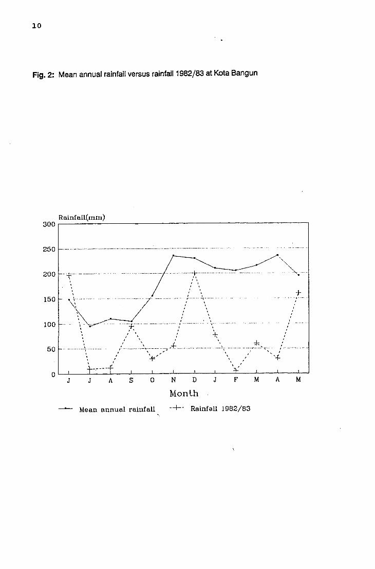
September there is much less precipitation (see Figure 2: Mean annual rainfall versus
rainfall 1982/83 at Kota Bangun) causing fluctuations in the water table of rivers and
lakes.
In addition to these seasonal dry spells, drought occurs periodically every 3 to 5 years
in connection with the southern oscillation of the El Nino, a current of the Pacific
Ocean. These droughts, however, are not very severe and the ecosystems are very
well adapted to such changes. Yet, there is another periodicity in droughts, also
related to the El Nino Southern Oscillation which occurs every 90 to 100 years. These
droughts are very severe. During the 1982/83 drought only 33 % of the average annual
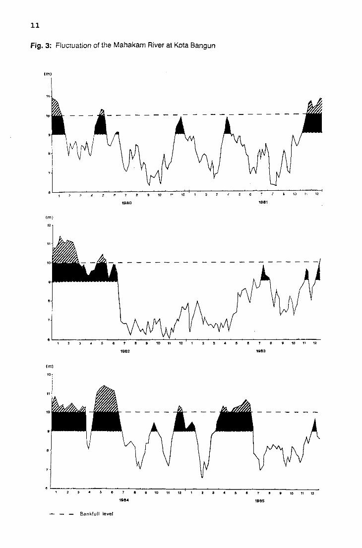
precipitation was measured at Kota Bangun (see Figure 2). Figure 3 shows the
fluctuation of the Mahakam River at Kota Bangun Station for the period 1980 to 1985.
The low water level during the 1982/83 drought is significant.
10
Fig. 2: Mean annual rainfall versus rainfall 1982/83 at Kota Bangun
RainfaU(mm) 300.---------------------------------------------------~
250
200
150
100
50
,
'--.......... /"'" ...... ----- "-........ + .................. -................. '"
" . . .
I
, . . . + ~ ~I" .. ~-.-........ ...... . ......... '-_ •. '7" .-.. '" ..... -... -........ : ...... -\ ....... .
~ /: ., . ,
J
~ .--/ :' . \, '\.W""""'-:- ... . ...... + ............... -.............. _ .. .
\
\ ' .. , , I '\ I
I \ , ,\ .
I ~~ .•• "-- ." ".~ ~- - ." ... ,._;; '"" +. .. -........ ,'-.- ...... -~ .... _ .. " .... ~~. I \, ..
I \ "... ..
: ~ \
. ...... ,. .
J A s o N D J
Monlh
, . I ,
, , /
. .
~, " . .• -. ~ .••...• ,.- ••.. :"- -.::" ..... I .•.. - ••..•• ~-.. -, "
-+
F M A M
-- Mean annual rainfall -+- Rainfall 1982/83
11
Fig. 3: Fluctuation of the Mahakam River at Kota Bangun
(m)
(m)
12
B
9 10 ,.. 1:
1980
10 1i 12
1981
B~----~--~--~------~--~----~----~~--~--------------------------------------------8 g 1011 12 3 5 8 g101112
1982 1983
(m)
11184 11185
- - - Bankfull level

12
In areas close to the Mahakam River, the fluctuations of the water table remained lower
than in the upper part and the tributaries. In many of the smaller rivers, the water table
sunk considerably, making sometimes even local transportation by Kentinting
impossible (Mayer, 1984).
Many lakes also dried out completely, such as the Jempang lake, and it is reported
that people used motorbikes to cross the river instead of boats.
The fluctuation of the lakes and rivers is related very closely with precipitation levels in
the upper regions.
The decline of the water table in the swamp areas also affected the forest vegetation. In
large areas the peat became dry and combustible and huge areas of swamp forests
burned.
4.2 Fire
Tropical rainforest ecosystems have a very high impact on the hydrology of rivers and
lakes; they retain precipitation and release it slowly and continuously. Swamp forests,
in particular, act like a sponge. During dry spells, the retained water from the forest
ecosystems helps to equalize fluctuations in the water table. Also, the soil is protected
from erosion and the rinsing away of nutrients and organic matter is prevented as
rainwater never falls directly on the bare soil.
The forest fires following the 1982/83 drought destroyed 2.7 million ha of forest land.
Especially logged over forests and peat swamp forests were very seriously affected.
The total forest cover was destroyed, while former primary forest areas were just lightly
disturbed.
After the fire, the bare forest soil was covered by ash, carbonized twigs and branches
and rotten debris. The first heavy rains eroded the exposed forest soil quite heavily.
Remaining topsoil, ash, twigs, branches and rotten debris were washed away and
drained into the river. During the first month after the fire the colour of the river
changed into a black-brown (personal communication) and water quality was affected.
13
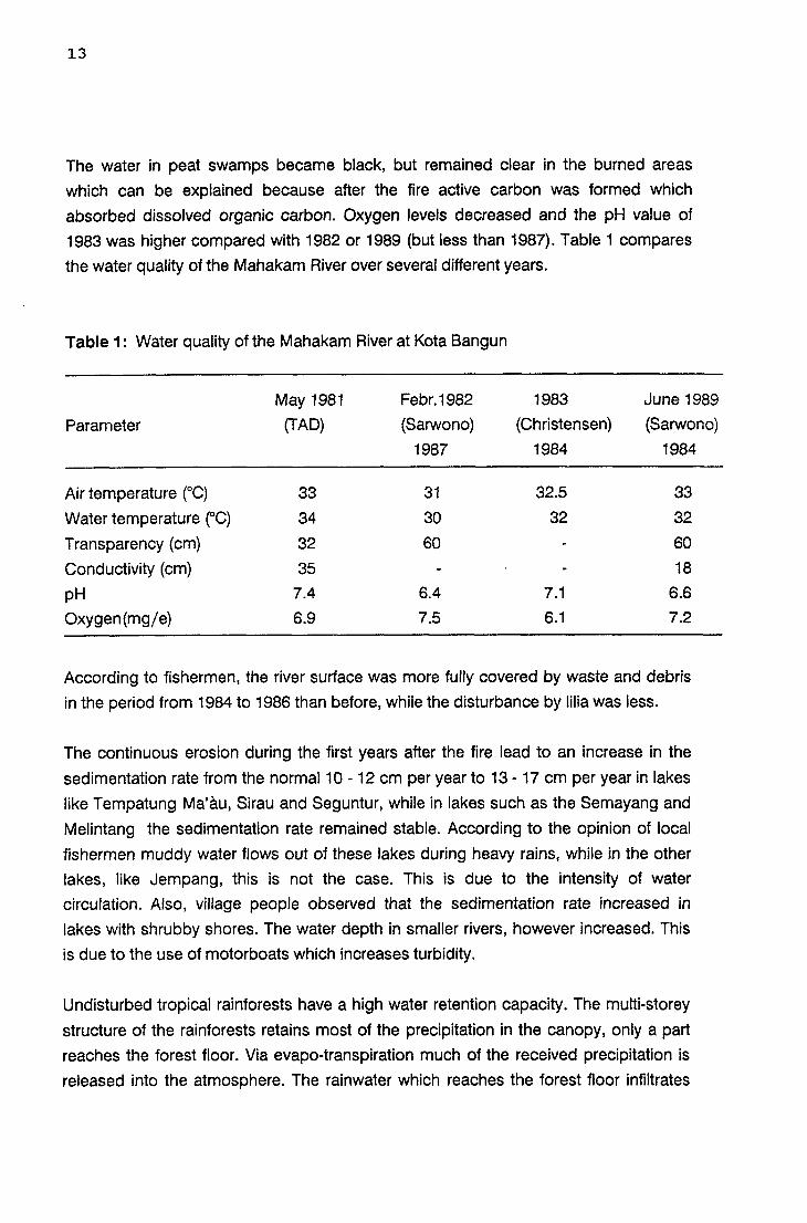
The water in peat swamps became black, but remained clear in the burned areas
which can be explained because after the fire active carbon was formed which
absorbed dissolved organic carbon. Oxygen levels decreased and the pH value of
1983 was higher compared with 1982 or 1989 (but less than 1987). Table 1 compares
the water quality of the Mahakam River over several different years.
Table 1: Water quality of the Mahakam River at Kota Bangun
Parameter
Air temperature (cC)
Water temperature eC)
Transparency (cm)
Conductivity (cm)
pH
Oxygen (mg/ e)
May 1981
(TA D)
33
34
32
35
7.4
6.9
Febr.1982
(Sarwono)
1987
31
30
60
6.4
7.5
1983 June 1989
(Christensen) (Sarwono)
1984 1984
32.5 33
32 32
60
18
7.1 6.6
6.1 7.2
According to fishermen, the river surface was more fully covered by waste and debris
in the period from 1984 to 1986 than before, while the disturbance by Iilia was less.
The continuous erosion during the first years after the fire lead to an increase in the
sedimentation rate from the normal 10 - 12 cm per year to 13 - 17 cm per year in lakes
like Tempatung Ma'au, Sirau and Seguntur, while in lakes such as the Semayang and
Melintang the sedimentation rate remained stable. According to the opinion of local
fishermen muddy water flows out of these lakes during heavy rains, while in the other
lakes, like Jempang, this is not the case. This is due to the intensity of water
circulation. Also, vii/age people observed that the sedimentation rate increased in
lakes with shrubby shores. The water depth in smaller rivers, however increased. This
is due to the use of motorboats which increases turbidity.
Undisturbed tropical rainforests have a high water retention capacity. The multi-storey
structure of the rainforests retains most of the precipitation in the canopy, only a part
reaches the forest floor. Via evapo-transpiration much of the received precipitation is
released into the atmosphere. The rainwater which reaches the forest floor infiltrates
14
the soil and is drained off slowly into the rivers. Thus, the forest is able to act as a
buffer. During heavy rains, water is retained and during droughts water is released. The
effect of the swamp forest in particular can be compared with a sponge. The uniform,
one-storey secondary forests have much lower water retention capacity; a great share
of precipitation is washed away superficially. The buffer effect is almost lost.
After the fire, the period of low water table levels in rivers and lakes was extended to
about 5 month. Also, the fluctuations of the water table reacts more quickly on
precipitation. High and low water peaks are much more common (personnel
communication). For the lakes the infiltration rate was decreased after the fire for about
50 %. This might be due to the fact that in the burnt area the precipitation is drained off
quickly into the lower areas, thus increasing fluctuation.

15
5. Effects of Drought and Fire on Fishery
Fish populations in the Middle Mahakam Area are adapted to seasonal drought
conditions. When the water table of the lakes and small rivers declines during the
period July to September blackfish flee into the peat swamp forests. They survive in
holes under large trees, which are covered with water even during dry spells (see
Figure 4) and are easily caught when the tree is felled. This catch method has become
very popular through the advent of the chainsaw. Catches weighing 50-100 kg per tree
are very common (Christensen,et ai, 1986).
The severe drought of 1982/83 also affected the peat swamp forests. The peat dried
out down to a depth of up to 1 m and thus affected the refugium of blackfish. Forest
fires damaged 385000 ha of swamp forests and, today, 110000 ha have to be
classified as open swamps. It can be assumed that all the blackfish in the burned
areas were exterminated.

16
Fig. 4: Blackfish surviving drought under tree trunks in peat swamp forest
17
Whitefish, in contrast to blackfish, fled into large rivers when the water table become
too low. During and after the drought, fishing pressure was considerably increased as
people were forced to search for other food sources, as rice, cereal and vegetable
harvests were partly lost by the effects of the drought. As a result whitefish represented
the favoured catch during the 1982/83 drought.
The 1982/83 drought and fire, as well as the overfishing in the Middle Mahakam area
which began in 1983, created considerable changes in fish species diversity and
population structure (Christensen,et ai, 1986). Some fish species like the Notopterus
(belinda) and the Pangasius (patin) disappeared completely from the market, while
other species started to breed at much smaller sizes, like the Thynnichthys (kenida) and
the Puntius schwanefeldi (Iempam). Overfishing is mainly due to the introduction of
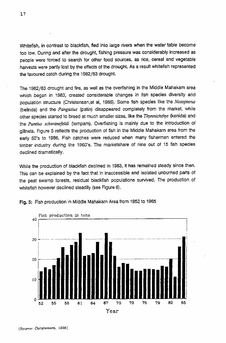
gillnets. Figure 5 reflects the production of fish in the Middle Mahakam area from the
early 50's to 1986. Fish catches were reduced when many fishermen entered the
timber industry during the 1960's. The marketshare of nine out of 15 fish species
declined dramatically.
While the production of blackfish declined in 1983, it has remained steady since then.
This can be explained by the fact that in inaccessible and isolated unburned parts of
the peat swamp forests, residual blackfish populations survived. The production of
whitefish however declined steadily (see Figure 6).
Fig. 5: Fish production in Middle Mahakam Area from 1952 to 1985
Fish production in tons 401~----------------------------------------------~l
I I ! I I
i ;
30 ~ ............................................. .
I
I ........................................................................................................ j
I 20 r--
10
OUL~~~~U..u .. ua.u~~~u.JU __ ua.u~~~u-.u .. ~
52 55 58 61 64 67 70 73 76 79 82 85
Year
(Source: Christensen. 1986)

18
Fig. 6: Production of blackfish and whitefish at central landing stage in Samarinda for the period 1980 to 1985
Production of blackfish
Production in tons 1000 I 1 I
80J------------ r:;:J 7;; I~~; !
1::=
600 ....................................................................................................................................... ::: .......... " ............. ::: ....................................... .. . -" ... ... ..~
e:J ::~ ::: 8 ~ m ill ~"I "'l .. ~ ..•
400 "''''''''''''''''''''''''!E!~I'''-''''''''''-''''''''''''''''''''''''''-''''''''''''''''''''mf ........ ·· ................ ·lm------d!!l-----~ ...... ~~~ .... · ::t ::1 ::: ~::: ::;
200 .......................... ~::I .............. ·-............ f:!1·· .... · .... ·· .... ·· ...... ·-· :::·· ............ ·: ............ 1::: .. · .. · .. · ...... · ...... :;01::: .. · .. ""· .... ·........ :3'''' t::: t::! ::~ ::: I ::~ ." ". :: ::1 . ::1 ::l .:::' ::~ ":-.::1
o :: ::1 ::: ::: H= ~ >~: :: 1980 1981 1982 1983
Production of whitefish
40
20
o 1980
_ BaWlS
~::::I PaUn
(Source: Christensen, 1988)
1981 1982
~ Jelawst
D Bel1da
1983
Year f· <:':1 Lempam
1984 1985
i ................................................................... 1
I --~------I
1984
! J
.................. ..1
1985
~ Pahal

19
Due to the continuous overfishing the catches per man-hour and man-year decreased
considerably.
Table 2 shows the production of various fish species at TPI Samarinda Sebarang for
the period 1980 to 1984.
Fish species Production in tons Percentage of species
1980 1981 1982 1983 1984 1980 1981 1982 1983
Gabus 478 210 452 660 808 49.9 19.2 36.8 56.6
Biawan 133 122 121 91 301 13.9 11.2 10.0 7.8
SepatSiam 72 84 103 72 107 7.5 7.7 8.4 6.2
Jelawat 50 79 49 28 23 5.2 7.2 4.2 2.4
Lempam 27 72 42 16 8 2.8 6.6 3.6 1.4
Puyau 6 51 24 8 13 0.6 4.7 2.2 0.7
Baung 32 67 51 77 102 3.3 6.1 4.2 6.6
Pahat 10 51 42 18 5 1.0 4.7 3.6 1.5
Patin 21 54 37 26 7 2.2 4.9 3.4 2.2
Pepuyu 35 63 58 38 137 3.7 5.8 5.0 3.3
Belida 17 50 35 9 5 1.8 4.6 3.1 0.8
Betutu 0 41 33 0.0 3.8 2.6 0.1
Keli 25 32 43 14 74 2.6 2.9 3.8 1.2
Lais 33 55 58 74 14 3.4 5.0 4.8 6.3
Others 19 61 51 35 22 2.0 5.6 4.3 3.0
Total 958 1092 1199 1167 1627 100 100 100 100
In the TPI area of Samarinda Sebarang, the production of peat swamp fishes like
Sepat Siam and Pepuyu was significantly decreased in 1983, while the production of
the lake fishes Jelawat, Lampan, Belida and Pahat were successively decreased since
1982 .
. Besides the destruction of the peat swamp forest habitat, which affected the blackfish
population solely in 1983, drought and fire affected the breeding of all fish species
through reduced water table and a change in water quality. Fish ponds, which
depended on surface water, completely dried out.
1984
49.7
18.5
6.6
1.4
0.5
0.8
6.3
0.3
0.4
8.4
0.3
0.1
4.5
0.9
1.4
100

20
In 1984, a bacterial fish disease infected all fish species except the Baung hitam. Most
heavily, however, those species were infected which were cultured in floating cages
like the Gabus, Keli, Penang and Sebat. The disease was almost certainly imported
from Java, where a similar outbreak occured in 1980/81 (Christensen, et ai, 1986). A
correlation between the outbreak of this disease and the incident of drought and fire
cannot be identified, however, the fish population had already been weakened and the
bad water quality, perhaps,led the fish population to become less resistant.

21
References
CHRISTENSEN, M.S., 1984: Interim report on floating cage culture trials. TAD, Samarinda.
CHRISTENSEN, M.S., MULU, A., AKBAR, A., 1986: Investigations into the fishery of the Middle Mahakam Area. Techn. Rep. No. 86-1, TAD, Samarinda.
CHRISTENSEN, M.S., 1987: Perubahan Struktur Jenis Ikan di Perairan Umum Wilayah Mahakam Tengah. TAD, Samarinda.
CHRISTENSEN, M.S., 1989: Techniques and economics of intensive cultivation of Jelawat and Lempam carp in floating cages. GTZ, Jakarta.
DISKAN I, PROP. KALTIM, 1989: Pemanfaatan Sumberdaya Perikanan dan Program Pengembangan Perikanan di Propinsi Kalimantan Timur. Dept. Pertanian. Jakarta.
KUSYARBANSYAH, M., 1982: Masalah Hama dan Penyakit Ikan Beserta Pananggulangannya di Kalimantan Timur. Diskan I. Prop. Kaltim. Samarinda.
LENNERTZ, R., PANZER, K.F., 1983: Preliminary assessment of the drought and forest fire damage in Kalimantan Timur. TAD, Samarinda.
MAYER, J.H., 1989: Socioeconomic aspects of the 1982/83 forest fire and the relation of local communities towards forestry and forest management in East Kalimantan. FR-Report No. 9.
RACHMADI, A., HARTONO, B., 1988: Forest fire impact on forest resource function. Dept. of Forestry, Jakarta.
SAANIN, H., 1987: Keadaan Perikanan di WMT tahun Empatpuluhan. TAD, Samarinda.
SALMANI, M.R., 1987: Keadaan Perikanan Perairan Umum di WMT Saat 1nL Diskan 11 Kab. Kutai., Tenggarong.
SARWONO, 1982: Jenis dan Kepadatan Plankton di Perairan Sekitar Kampung Pela Kecamatan Kota Bangun. Univ. Mulawarman, Samarinda.
SARWONO, 1987: Gambaran Umum Perikanan di Mahakam Tengah. TAD, Samarinda.
SARWONO, ARMEINADI, 1989: Pengembangan Perikanan Perairan Umum di Wilayah Mahakam Tengah. Deptan., Jakarta.
SCHINDELE, W., THOMA, W., PANZER, K., 1989: The forest fire 1982/83 in East Kalimantan. Part I: The fire, the effects, the damage and technical solutions. FRReport No. 5.

22
SHIMOKAWA, E., 1988: Effects of a fire of tropical rain forest on soil erosion. In: A research on the process of earlier recovery of tropical rain forest after a large scale fire in Kalimantan Timur, Indonesia (Ed. by Tagawah, H., Wirawan, N.). Kagoshima University.
SPOTIE, S., 1979: Fish and invertebrate culture. Water management in closed systems. John Wiley & Sons Inc., New York.
WELCOMME, R.L., 1979: Fisheries ecology offloodplain rivers. Longman, London.
ZEHRFELD, E.H., et al., 1985: Produksi dan Pemasaran Ikan Hasil Tangkapan dan Budidaya di Daerah Mahakam Tengah dan Sekitarnya. TAD, Samarinda.