Embed Size (px)
Citation preview

Effects of the Eruption of Paricutin Volcano on
Landforms^ Vegetation, and Human Occupancy
JOHN D. REES
I N T R O D U C T I O N
The environment and rural economy of the Itzicuaro Valley, Michoacán, in west-central Mexico was disrupted on 20 February 1943, by the eruption of a volcano 2 km from the Tarascan Indian village of Paricutin. The onset of the Paricutin eruption was preceded by 2 weeks of mild earthquakes that grew in intensity before the outbreak, after which the seisms and underground noises ceased (Foshag and González 1956:355). The eruption took place at about 4:30 p.m. on a maize field located in a small shallow valley 2 km southeast of the village. The village of Paricutin is located 320 km west of Mexico City in the state of Michoacán in the west-central portion of the Mexican volcanic axis known as the Meseta Tarasca. The Meseta Tarasca is formed of Tertiary and Quaternary volcanic rock materials overlying older sediments and extrusives of the southern escaömen t of the Central Mexican Plateau.
The cone of Paricutin Volcano is situated on the northern flank of Tancit-aro, in the upper watershed of the westward-trending Itzicuaro Valley (Figure 9.1). Tancitaro is an eroded major Pleistocene volcano that rises to over 3845 m to make it the dominant volcano of the region. To the northeast of the Paricutin cone, another volcano, the twin peaks of Angahuan rise to over 3290 m. The Paricutin cone is the most recent of the more than 150 cinder cones that are identified within approximately 1600 km^ around the newest cone (Williams 1950:168). The majority of the cones are composed of semi-consolidated bedded ash, lapilli, and volcanic bombs; lava flows make up a
249 VOUDANIC ACTIVITY AND HUMAN ECOLOGY Copyright © 1979 by Academic Press, Inc.
All rights of reproduction in any form reserved. ISBN 0-12-639120-3

250 JOHN D. REES
102°00
1^20 102°30 1 0 / 00
FIGURE 9.1. Map of Parícutín region^ Michoaca'n, Mexico.
small area of the surface of most cinder cones. Two types of cone shapes are common: (a) those that are conical with a flat-floored crater, and (b) those that have been breached by volcanic explosions or lava flows and subsequently eroded, leaving one or more sides removed. Flat-floored craters are sometimes cleared of timber and utilized as sites for long-fallow, short-cropping maize cultivation. Long fallow is a result of the less fertile and more droughty soils of crater floors.
Although volcanoes and cinder cones are the most imposing landforms, lava flows cover large areas of the Itzicuaro Valley. The lower slopes of Paricutin and many older cones are buried by extensive lava fields. In some cases, the lava flows are narrow on the higher slopes and fan out on lower ones. Flows from Tancitaro and from cinder cones have produced a bench-and-cliff topography. The majority of the ancient flows have undergone considerable weathering and possess a true soil surface that is forested or is in long-fallow, short-cropping plow agriculture. The more recent flows, however, are lava badlands with an extremely rough, blocky rubble of vasicular basalt that is difficult to cross on foot and usually prevents entry by cattle and other hoofed animals. Although not used for crops or grazing, these lava badlands produce timber that is exploited by Tarascan Indian woodsmen, who are forced to backpack timber products to sites from which pack animals can operate.
Examination of air photos taken in 1934 for the Departmento Agrario shows that the bottom of the Itzicuaro Valley prior to the eruption of Paricutin

9. EFFECTS OF THE ERUPTION OF PARÍCUTIN VOLCANO 251
SUMMARY HISTORY OF THE PARICUTIN ERUPTION
On the day of the eruption, a resident of the village of Paricutin planting crops at the site claimed that he witnessed a small explosion on the maize field from a vent that had suddenly opened in a shallow pit where storm runoff had drained during past rainy seasons. The initial explosion was followed by emission of steam and sulfurous gases and a small eruptive column of fine dust and small incandescent stones. The 30-cm vent widened with the slumping of molten materials, and the eruptive column gradually increased in size. By midnight, the fissure activity had become violent. A large eruptive column was accompanied by a roaring sound, lightning flashes, and the violent ejection of great numbers of incandescent rocks (Foshag and González 1956:385). At midnight of the first day the cone measured approximately 6 m high; 6 days later, it became 167 m; by the end of 1 year, the cone had grown to a height of 325 m. Intermittent eruptions continued until in 1952 the cone rose to a height of 410 m above the former maize field; its height, however, is not apparent because of repeated lava flows that have covered the lower slopes of the cone (Foshag and González 1956:355).
The first month of Paricutin's activity was dominated by the explosive ejection of volcanic bombs, blocks, and lapilli that brought about the rapid cone building. Most of the ejecta were blocks (angular chunks of old rock from walls of the magma conduit), and bombs (globs of magma, some of which were still plastic enough to alter their shapes on impact). Most bombs were from 30 cm to 1 m in diameter and fragmented on impact with the ground (Bullard 1976:355), Every few seconds showers of incandescent rock material were ejected from the crater. The explosive violence could be heard as far as Guanajuato, 350 km distant (Bullard 1976:355). By 6 March 1943, about 83 million m^ of bombs, blocks, lapilli, and ash had been ejected from the crater vents of Paricutin; ejection of pyroclastic material averaged 6 million m^ daily in this early period and then decreased to an average of 76,000 m^ thereafter for several months (Fries 1953:606-607).
Lava flowed from the cone vents from the first day and by 24 February issued in a broad sheet 700 m long and advanced at a rate of 5 m/hr. Surges of lava flow repeatedly breached the weak walls of the cone during the first days of eruption. Pauses in the flow allowed the cone wall to build up again by accumulation of volcanic bombs, lapilli, and ash. The shape of the cone thus
was composed of older lava benches and other depositional surfaces. These depositional surfaces were initially produced by airborne ash and lapilh, later augmented by alluvial deposits from nearby slopes. Before the Paricutin eruption, older lava benches and depositional areas made up the cultivable lands, whereas the steep bench cliffs, recent flows, cinder cone slopes, and upper slopes of Tancitaro and Angahuan were heavily wooded.

252 J O H N D. REES
alternated from a horseshoe to a cone. After the first month of activity the buildup of the cone mass was such that lava no longer broke through the walls from the crater. Instead, surges of lava flowed from vents on the outer flank of the cone, causing slumping and partial collapse of a cone section that was later filled in by the bombs of the next explosive period (Foshag and González 1956:395).
The heavy cineric phase began on 18 March and lasted until 9 June 1943. The change from a volcanic bomb stage (characterized by little ash but great amount of bombs) to the succeeding cineric phase was a result in part of choking of the vents in the cone by debris as volcanic bombs rolled back down the inside slopes of the cone (Foshag and González 1956:430). During the cineric phase a nearly continuous eruptive column of ash rose to heights of 8000 m above the cone. During this period the ashfall was the greatest in Paricutin history. Winds carried the ash far to the north and east. Fine ash fell in Mexico City (320 km away), while in Uruapan (25 km to the east) street lamps and auto headlights were necessary during the daytime. In nearby San Juan Parangaricutiro roofs of houses were cleared every 2 or 3 days to prevent collapse (Foshag and González 1956:399). During the summer of 1943 ash emission decreased, and the lavas rose in the central cone higher than in any subsequent period. Soon after, lava cascaded from a lava fountain 100 m below the crater rim. In July other flows injected under earlier flows carried the crusted earlier flows along for 400 m (Ordonez 1947:41, 42). In October 1943, a parasitic cone developed at the northeast base of Paricutin and erupted with vigor until January 1944. This second cone, called Sapichu, rose to over 70 m and developed a horseshow shape as lava flows breached the northeast side. In January 1944 the main cone renewed explosive activity after the relative quiet of the Sapichu period. New lava vents opened at the southwest base of the Paricutin cone; vents in this area produced all of the lava flows for the next 3 years.
From January to August 1944 these vents yielded the San Juan flow that moved east, north, and then west, to flow over and past the village of San Juan Parangaricutiro. This flow was the most voluminous of the Paricutin flows and extended over 10 km in length. From September to November 1944 the Paricutin flow advanced at a rate of 6 m/hr northward through Paricutin village and completely covered the village site, and reached the earlier San Juan flow (Bullard 1976:363). During mid-November 1944, additional vents opened on the southwest base of the cone; lavas from these vents flowed mostly over the San Juan and Paricutin lavas. Similar activity from these southwest vents continued through 1945 and 1946.
In January 1947 the cone walls of the main cone slumped on the northeast and southwest sides, and new vents adjacent to the slumping began emitting lava that flowed intermittently during 1947. From December 1947 until the end of activity in 1952, most of the major lava flows came from the northeast vents, the most prominent of which was called new Sapichu. Flows from this vent were nearly continuous from February 1948 to the sudden cessation of lava

9. EFFECTS OF THE ERUPTION OF PARÍCUTIN VOLCANO 253
emissions on 25 February 1952 (Wilcox 1954:287-288). Flows of the later years piled up in depth around the cone and in some cases moved far enough north to cover more uncovered ground enclosed by the San Juan and Paricutin flows of 1944. During the last years of the eruption, ash emissions and explosive ejection of bombs continued to occur at intervals. After lava eruptions ceased, only weak explosions occurred and eruption of pyroclastics ended on 4 March 1952 (Wilcox, 1954:289). The only form of activity since that time has been the gentle emission of warm acidic water vapor from fumarole vents near the cone rim and from 12 vents on the lava flow immediately west of the cone.
In the 9 years and 11 days of eruption history, the Paricutin lava flows covered 24.8 km^ of old ground area; the flows have a calculated total volume of 700 million m^ (Fries 1953:611). Lava thickness is at a maximum (over 242 m) near the cone, where lava piled up over previous flows, and a minimum, 3 m, at the outer edge of the lava field (Williams 1950:227). Although sizable, the Paricutin lava field is much smaller than some geologically recent flows of nearby cinder cones. For example, the Capacuaro cones (northeast of Paricutin) produced a lava field of 155 km^ with an average lava thickness of over 60 m. This is 6.25 times the area and over 32 times the volume of the Paricutin lavas (Williams 1950:203).
The Paricutin lavas are generally classified as the Aa type. The surface of the Paricutin flows are a jumble of irregularly shaped blocks with jagged and broken surfaces and with a scoria texture; color is from dark brown to black. The lavas of February 1943 are olivine-bearing basaltic andesite containing 55% silica; succeeding ejecta are progressively more salic until in 1952 the ejecta contain over 60% silica (Wilcox 1954:281). This increase in silica, acidity, and viscocity has been often observed in other eruptions. All of the Paricutin lavas and pyroclasts are classified as intermediate between the acidic (having over 66% silica) and basic (having less than 52%) (Bullard 1976:51). The Paricutin basaltic andesites are similar to ejecta from the younger volcanoes in the nearby area (Williams 1950:165). It can be expected that the Paricutin lavas and pyroclasts will eventually weather into soils similar to those found in the region.
For the Paricutin eruptions. Fries calculated the yearly total weights and volumes and average daily weights of lava and pyroclasts (see Table 9.1). The table gauges the persistence of the lava and pyroclast eruptions and highlights the sharp decline in eruption volume after the second year. Fries estimated that these rock materials would have occupied about 1.4 km^ in the magma chamber. Lava was estimated to make up about 27% of the total (by weight), with pyroclasts making up the balance (water not included in the calculations) (Fries 1953:611). Measured in cubic kilometers of ejected rock material, the Paricutin eruption is minor as compared with more major eruptions in recent historic time. For example, in the Mount Katmai, Alaska eruption in 1912, 11 km^ of dense horizontal ash flow erupted in less than 20 hours; an additional vertical ash emission of 16 km^ reached Kodiak Island some 160 km away and dropped 30 cm of ash. In an earlier eruption occurring in April 1815, the

254 JOHN D. REES
TABLE 9.1 Total Weight and Average Daily Weight of Pyroclastic Material and Lava Erupted at Paricutin, by Years, from 1943 through 1951«
Ash Lava Average T/ -v*-»l daily 1 Ota! daily
Weight Weight weight weight Duration Volume (million Volume (million (million (thousand
Year (days) (million m i 1 metric tons) (million m ) metric tons) metric tons) metric tons)
1943 314 601 1022 107 203 1225 3900 1944 366 280 476 122 232 708 1930 1945 365 148 252 98 186 438 1200 1946 365 103 175 87 165 340 930 1947 365 98 167 79 150 317 870 1948 366 28 48 76 144 192 520 1949 365 21 36 48 91 127 350 1950 365 16 27 40 76 103 280 1951 365 14 24 43 82 106 290
Total 3236 1309 2227 700 1329 3556 1100
"Source: Fries, 1953:611.
Tambora Volcano on the island of Sumbaya, Indonesia, yielded about 100 km^ of pyroclasts. This eruption resulted in the death of 92,000 people (Macdonald 1975:110, 118).
There is no official record of human death caused directly by the Paricutin eruption but the devastation of villages and agricultural and forest lands forced the migration of thousands of inhabitants from the valley. Two villages were engulfed by lava; three others were partially abandoned owing to heavy ashfalls on roofs, crops, pastures, and forests. Incomplete success and refugee discontent at government-sponsored resettlement sites caused many refugees to return to their former lands where they attempted crop growing and/or forestry.
REVIEW OF LITERATURE DEALING WITH PARICUTIN
The eruption of a new volcano in a populated farming area attracted considerable scientific attention; literature deahng with the eruption is voluminous. Hatt (1948) listed over 150 items in his bibhography of Paricutin Volcano, most of which, however, are descriptions of eruption behavior based on brief field visits. Foshag and González (1956) presented a detailed description of the first 2^2 years of the volcano. Bullard (1976) described the entire eruption history in a chapter on birth of new volcanoes. Williams (1950) studied the other volcanoes of the region, and Wilcox (1954) analyzed the petrology and speculated on the nature of the magma body. Segerstrom (1950, 1960, 1961, 1966) dealt with the erosion of the ash mantle and modified

9. EFFECTS OF THE ERUPTION OF PARÍCUTIN VOLCANO 255
PRE-ERUPTION SETTLEMENT A N D E C O N O M Y
The villages of the Itzicuaro Valley are located on valley flatlands at sites not too distant from seeps or springs to serve for domestic use and stock watering. Most villages were founded in the sixteenth century by Spanish monks who resettled the Tarascan Indians from their mountain hamlets to sites on valley flatlands better suited for plow agriculture and close supervision.
The modern Tarascan culture is a mixture of pre-Golumbian, colonial, and modern Mexican traits. Pre-Columbian characteristics predominate in the Tarascan language, in major food crops, in the diet and food preparation, and in ceremonial use of certain wild plants. Colonial Spanish influence survives in a conservative form of Roman Catholicism, and in the social structure with its dual political and religious hierarchy and obligatory rituals and feasts that form the prime basis for social prestige. Many of the economic and material aspects of Tarascan lifestyle also date to colonial times. Examples include the village grid plan, the house types, the land tenure system, sixteenth-century Mediterranean agricultural technology, the presence of some European orchard and field crops, and the cottage production of handicrafts (West 1948:33-71).
Villages whose residents consisted of Tarascan Indians or their Spanish-speaking descendants and who were later disrupted by the Paricutin eruption had the following population data in their 1940 census: San Juan Parangaricut-iro (1895), Zirosto (1314), Angahuan (1098), Zacán (876), and Paricutin (733). At the time of the eruption, the villages were in communication with other areas of Mexico. Their main contacts were through Uruapan and Los Reyes, the regional market towns where the villagers sold their small-crop surpluses
drainage, revegetation, and other effects. Work done on the effects of volcanic activity on plant life was published by Eggler (1948, 1959, 1963), and colonization of the cone and lava was recorded by Beaman (1960, 1961). A folk narrative of responses to events associated with the volcano is presented by Gutiérrez (1972). Impressions of individual and group reaction to conditions brought on by the eruption are presented by Nolan (1972). Studies by Rees (1961, 1970) describe the impact of the eruption on the ecology and economy of the area. Estimates on the damage to forests and crops during 1943 and 1944 were made by Arias Portillo (1945).
The present chapter will review the eruption history and pre-eruption conditions, and discuss the subsequent changes in landforms, vegetation, rural economy, and human settlement resulting from the eruption. Field reconnaissance of the affected area was conducted from October to December 1957, and brief visits paid in July 1965, December 1967, October 1972, and September 1978. Portions of the chapter have been adapted from Rees (1970), with additional information on vegetation, soils, agriculture, and forestry based on research conducted in the region in 1967-1968 (Rees 1971), and in the devastated area in 1972.

256 JOHN D. REES
and forestry and crafts products, and where they purchased factory-made goods in return. Contacts beyond the immediate region were made by traders and those who did harvest labor beyond the Tarascan-language region. These outside contacts, and the government primary school present in each village, helped to expand the use of the Spanish language and accelerated the partial integration of the Tarascans into the national Mexican culture. Use of the Tarascan language had noticeably declined by the time of the 1940 census in two of the settlements affected by Paricutin: Zirosto and San Juan Parangaricutiro (West 1948:19).
Until the late nineteenth century all lands in the Upper Itzicuaro Valley were communal, with title deeded to individual villages. The village community held title to all the land, and village residents inherited or purchased use rights to village house lots, to parcels on the open fields, and to parcels in the forests. After the beginning of the twentieth century, individuals were allowed to register their individual usufruct lands; thus, conversion of village land to deeded private property took place. This was called to a halt when the Agrarian Code was enforced in the 1940s. In the 1940s, however, the bulk of the cropland was not registered, and few of the registered parcels were sold to outsiders.
At the time of the eruption, two types of traditional land ownership, communal and private, existed in the villages. A third type, the ejido, had been introduced by the federal government at Zacán prior to the eruption. (The large Mexican private estate, the hacienda, existed only in non-Tarascan areas beyond the upper Itzicuaro Valley.) The ejido is a type of communal land tenure in which the federal government holds the title, and the use rights are held by individuals belonging to the village ejido organization. This new type of land tenure was introduced at the resettlement village of Zirosto Nuevo, 2 km northwest of Zirosto, and at resettlement villages beyond the Itzicuaro Valley.
At the time of the eruption, as is still the case today, most village families practiced subsistence agriculture supplemented by forestry and grazing. Crop production methods were traditional, involving manual labor and use of the wooden plow pulled by two oxen. Improved hybrid maize varieties and chemical fertilizers were not accepted by most families. Maize was produced, often intercropped with beans and squash, on unfenced plots on the open fields, on fenced plots on nearby slopes, and on shifting cultivation sites within the forest. Most open field plots and fenced plots on adjoining slopes were fallowed every other year. The use of the digging stick and the hoe was limited to house-lot gardens and steep shifting cultivation sites. The shifting cultivation sites usually required longer fallow periods, and the less fertile plots often were allowed to return to forest. On the open fields the ground was prepared by plowing under the weed growth of the previous fallow during late summer or early fall, and then cross-plowed before seeding took place in late April or early May. The maize was plowed at least once to ensure good drainage for the seedlings and to suppress weeds; a second weeding cultivation was sometimes carried out. The maize and bean harvest, generally in late December, was

9. EFFECTS OF THE ERUPTION OF PARÍCUTIN VOLCANO 257
done by the entire family and some hired labor from a nearby village. Upon the agreed date of the end of harvest, the outside fences of the open fields were let down and grazing animals soon removed all signs of cultivated plant life, except the furrows.
The presence of human and animal refuse on house-lot gardens permitted intensive cultivation of horticulture. The women of the family attended to several vegetables, which included roasting ear and ceremonial maize, European cabbage, squash, broad beans, chayóte {Sechium edule), and husk tomato {Physalis angulata). Medicinal and culinary herbs and ornamental flowers were grown. Deciduous fruit trees such as peach, pear, apple, tejocote (Mexican crab apple—Crataegus mexicana), and capulín, a native cherry {Prunus capuli), grew unattended. Fruit was the only house-lot garden crop sold outside the village but was usually undersized, and the larger varieties were commonly hail-damaged.
Subsistence agriculture provided the principal, though not the only, source of income for the villagers. Forestry was important as a supplementary source for most agriculturahsts, and the primary source of income for the landless. The production of handicrafts in the villages occupied a few full-time speciaHsts but was the part-time occupation of many who were engaged in other economic activities; the total output for sale outside the village was of little significance. Hunting and gathering existed but were of minor importance.
In the forest, women of the village gathered edible greens, mushrooms, and various other edible and medicinal plants for family use and for sale in Uruapan. At Christmas time, decorative plants and foliage were gathered for sale to Uruapan residents for making Nativity scenes. In the forest, too, most of the cattle grazed, as did poor-quality sheep kept for their meat and wool. Almost all the families in the village owned a burro, a dog, some pigs, and several chickens. Horses and mules were not common because of their high initial cost and the need for higher-quality pasturage. Most farming families owned or had access to a pair of oxen; cattle were highly valued as animals for plowing and as capital investment.
Dead time in the agricultural cycle had always been taken up by forestry activities. Pine beams were hand-hewed, and pine and fir shingles were hand-spHt. Lumber was hand-sawed or hand-hewed into planks or boards. Pine resin was collected most commonly from Pinus oocarpa, Pinus leiophylla, Pinus michoacana, and Pinus montezumae, and was shipped to tuöent ine distilleries in Uruapan. Oak charcoal was produced exclusively for non-Tarascan market towns. All these originated from timber growing on pure communal lands or on forest parcels controlled by individual use rights. Villagers lacking use rights to croplands often depended entirely on forestry for subsistence.
At the time of the eruption, government policy limited the scale of timber production. Existing forestry regulations and new laws enforced in March 1943 required written governmental approval for the cutting of timber to be sold, taxes to be paid on timber sold, and documents accompanying each shipment.

258 JOHN D. REES
IMPACT OF AIRBORNE A N D WATER-TRANSPORTED ASH O N THE RURAL ECONOMY FROM 1943 T O 1945
Ashfall was greatest during the period 18 March-9 June 1943. During this period, known as the heavy cineric phase, great damage was done to buildings, croplands, and forests. As far as 5 km to the north of the Paricutin cone, large tree branches were broken, and throughout the area saplings were bent over under the burden of ash. In the fields within 8 km of the cone, crops were killed and agriculture rendered impossible. But famine did not follow, largely because the eruption began 60 days after the end of the annual maize harvest, at a time when most families had already stored several months' supply of grain in their houses.
The eruption began in February and the sowing of maize usually takes place in March and April. On sites where maize seeds were planted after the eruption, germinating seedlings met with a harsh environment. In areas near the cone, ash was falhng faster than maize could grow through it, whereas throughout the ashfall zone, undernourished seedlings were subjected to abrasion by both falling ash and ash blown across the surface by wind. Maize was killed where the plants were buried or where fungus diseases entered ash-bruised tissues. Attempts to plant seedlings in shallow pure ash where roots might penetrate down to the old soil failed as a result of fungus attack during the heavy ashfall. Parcels on the open fields with more than a 14-cm ash depth could not be cultivated because the wooden plow in general use at the time did not reach the old soil surface. Small-scale plantings of maize, however, were possible on house lots where ash was removed by hand and where abrasion by windborne ash was less. In sum, heavy ashfall during the first 2 years of the eruption dissuaded most of the Tarascan farmers from planting maize or other crops. On the other hand. Arias Portillo (1945:28) reported excellent crops of wheat and barley beyond the Itzicuaro Valley, where only 3 cm of ash fell.
Fruit crops in areas as far away as 48 km were adversely affected by the heavy ashfalls of 1943 and 1944. Within the area where ash depth averages at least 25 cm, fruit trees were defoliated by falling ash, whereas beyond the Itzicuaro Valley (around Uruapan), fine ash entered avocado flowers, preventing pollination. The avocado crop loss around Uruapan was more than U.S. $300,000 by the end of 1943 (Ordonez 1947:33).
Ashfalls also upset the ecological balance between insects and crops. Near Los Reyes (25 km west of Paricutin), subtropical and tropical fruits were able to
The individual Tarascan cutting only an occasional pine found the regulations difficult to comply with, and lacking documentation, his burro-loads of timber products became contraband. The federal government, not wanting to provoke violence, permitted small-scale illegal production and sale, but prohibited larger shipment of timber to other areas of Mexico.

9. EFFECTS OF THE ERUPTION OF PARÍCUTIN VOLCANO 259
grow more successfully for several years following the heavy cineric phase because of the temporary elimination of a destructive fruit fly by the falHng ash. On the other hand, ashfall killed a beneficial insect that preyed upon a sugar-cane boring insect in the Los Reyes region. From January 1944 to May 1945, an estimated loss of 80-90% of the sugar-cane crop resulting from a plague by the cane-boring insects was reported; a total area of 1263 ha was affected (Segerstrom 1950:22).
Damage to agriculture was compounded by water-transported ash. With the onset of the summer rains of 1943, the unconsolidated ash was moved by landsliding, sheetwash, and channel erosion into ash-choked streams with increased cutting power provided by the ash. Large volumes of ash and soil were removed from the upper Itzicuaro Valley westward and deposited on the flood plains near Los Reyes. These floods destroyed the irrigation system by breaking up dams and silting up canals, and laying down beds of ash over 887 ha of sugar-cane land. A total of 2500 ha of sugar cane and rice was devastated (Arias Portillo 1945:27). With the incidental blocking off of half the Rio Itzicuaro watershed by the San Juan lava flow of 1944, no additional sugar-cane land had since been silted over. Though more than half the ash-silted cane land was in cultivation by 1944, cane fields were stfll being reclaimed by 1946 (Segerstrom 1950:22). Where water-transported ash had filled the basins and valleys in the upper Itzicuaro watershed, ash playas were formed on many of the open fields, having an ash cover of considerable depth that prevented crop plant seedlings from tapping resources from the deeply buried soil.
Ashfall during the heavy cineric phase caused death to many livestock. A loss of over 4500 cattle and 500 horses was reported (Arias Portillo 1945:30), and an undetermined number of sheep and goats died as a result of breathing volcanic ash. Animals that were initially exposed to, and later removed from, the deep-ash zone often died months later; animals thus weakened were quickly disposed of by their Tarascan owners to outside buyers at greatly reduced prices. Upon postmortem examination, it was revealed that the lungs of animals that breathed volcanic ash were congested with an ash-mucous coating that interfered with respiration. The teeth of many dead animals also showed excessive wear from grazing on ash-coated forage. The loss of cattle amounted to a disaster to the Tarascan farmer: First, it represented an inability to plow even if conditions were permissible; second, it deprived a young farmer of the means to accumulate enough capital to purchase use rights on the open fields and to set up separate housekeeping for his family.
After the end of the heavy cineric phase (June 1943), an intermittent ashfall continued. During this period an increasing number of villagers turned to the poorest-paying of traditional forestry activities: the collecting and selling of firewood. The huge volumes of broken branches during the heavy cineric phase were made available to local residents. However, there was the problem of transportation because of the decreased numbers of pack animals and the scarcity of forage near the volcano. Firewood collection and the sale of firewood increased in the local region until prices were driven down to near

260 JOHN D. REES
CHANGES IN H U M A N SETTLEMENT CAUSED BY ASHFALL A N D LAVA INVASION
During the nearly 3 months of the heavy cineric phase, the people of the upper Itzicuaro Valley chose to remain in spite of the fact that most land within 14 km of the volcano was made useless for agriculture and grazing. The officials of the affected villagers, however, took steps to seek federal and state aid. Surveys of possible refugee resettlement areas were made by the Secretaría de Recursos Hidráulicos, Secretaría de Agricultura y Ganadería, and other agencies. Government officials considered several privately owned haciendas for expropriation or purchase. Early in May 1943 the federal government made a purchase of a hacienda at Caltzontzin (5.5 km east of Uruapan) with 100 ha of arable land, 160 ha of woodland, and 5 ha of avocado orchards, together with several buildings. Existing nearby ejidos were also reviewed for parcels with enough surplus arable land to sustain a relocated village. A transfer of over 200 ha from the adjacent San Francisco Uruapan ejido was made to provide additional cropland, timberland, and pasture.
On 15 June 1943, the village of Paricutin was threatened by lavas that moved to within 20 m of the outskirts of the village (Foshag and González 1956:408). The threat of inundation by lava forced the residents into taking action. The government helped to resettle the entire village on the hacienda at Caltzontzin, and by 10 July, the entire population of Paricutin and its possessions were successfully relocated on the new site. Former wooden houses were dismantled and moved to the new site, where heavy slab timbers were milled into lighter-weight lumber to be utilized for later construction; temporary stablelike sheds were constructed for use as shelter during the initial stage. By September, a classic Mexican village with a rectangular grid plan was laid out, and the construction of mestizo, or non-Indian, houses was completed. The communal ejido organization was formed by March 1944, individual parcels were assigned to male heads of families, and the resettlement was complete.
uneconomic levels. The low prices for firewood rendered shipping the surplus to more distant towns unfeasible. Similarly, there was a drop in local price of charcoal. Sale beyond the immediate market towns was curtailed by existing federal forestry regulations.
The collection of pine resin, traditionally a poorly paying part-time occupation, came to a complete halt during the heavy cineric phase. Ash fell into the collecting cups of the pine, and resin that was thus contaminated was found unacceptable by the distilleries in Uruapan.
Exploitation of the standing timber proved to be the only form of resource utilization that sustained a sizable population in areas of heavy ashfall. As the months of eruption wore on, increasing quantities of hand-hewn lumber products were made and sold illegally, both locally and to other areas of Mexico.
9. EFFECTS OF THE ERUPTION OF PARÍCUTIN VOLCANO 261
In August 1943, a second relocation took place when 363 families, mostly from Zirosto and San Juan Parangaricutiro, were moved to Miguel Silva, located 45 km southeast of Uruapan. Miguel Silva was developed on 2616 ha transferred from another ejido for refugee settlement; only 400 ha were arable land. All the relocated families received a village house lot, but many were without the additional allotment of cropland. At Miguel Silva, the government supervised the construction of adobe and shingle-roofed houses. The climate and soils of Miguel Silva, however, were completely different from that of the Itzicuaro Valley. The clay soils and the warm subtropical climate did not accommodate the Sierran crop plants. In addition, potable water was not available until 1946, and over a hundred died from typhoid and other diseases between 1943 and 1946. There was also resentment of the landless against those with allotted cropland; distrust developed between factions from Zirosto and San Juan Parangaricutiro. By 1945, many of the former villagers from Zirosto returned to their homeland; eventually, almost all of the refugees from San Juan Parangaricutiro left for the new village of Nuevo San Juan.
In June 1944 San Juan Parangaricutiro (the county seat of the municipio of the same name) became the second village to be threatened by lava flows. Prior to the lava, there had been a steady movement of residents to other areas, not only to Miguel Silva, but also to ranchos located on Parangaricutiro's ample communal lands to the southeast of the volcano, to Uruapan, and to other settlements. In June the government moved the remaining inhabitants of the destroyed village to the new site of Nuevo San Juan established on the former hacienda Los Conejos (6 km west of Uruapan). The villagers were given house lots of the same size and at the same relative location as they had in the former village. Not all the timber used at Nuevo San Juan was remilled, as it had been at Cultzontzin and Miguel Silva. Some dismantled wooden houses were reconstructed when the timbers were small enough to be trucked to the new site.
The town of Zirosto, located 7.7 km northwest of the volcano, suffered through the heavy ashfall of 1943 that devastated its agricultural and forest lands. Many of the residents went elsewhere temporarily until it became possible for them to return to cultivate crops again. Six hundred went to Miguel Silva, where the outbreak of diseases, internal dissension, and the lack of cropland caused them to return to Itzicuaro Valley. Many of the inhabitants, however, remained in Zirosto and in nearby Barranca Seca, where an outside contractor estabhshed a lumber mill in 1944 to exploit timber killed by the eruption. By 1945, an estimated 20% of the inhabitants had moved from Zirosto and from the resettlements at Miguel Silva to Uruapan, Charapan, Tijuana, Mexicali, and other distant localities. Most of those who migrated at that time have not returned. Barranca Seca later became known as Zirosto Nuevo when in 1952 the federal government transferred 371 ha from another ejido, and purchased 184 additional ha from private owners.
Nearby Zacán, located 7.8 km northwest of the volcano, was similarly affected by ashfall but not by lava. Zacán was more fortunate than other villages of the valley in that it received less ash, and that the ash that was

262 JOHN D. REES
C H A N G E S I N D R A I N A G E A N D G R O U N D W A T E R C A U S E D BY T H E LAVA F IELD
The scarcity of water flow in the form of permanent streams and lakes is a distinctive feature of the Paricutin region. Despite the average annual precipitation of over 1500 mm, most surface moisture is quickly absorbed into the porous volcanic soil. Repeated drilling for subsurface water to depths of over 100 m has failed to locate exploitable water supplies. Only at a few canyon sites, where intermittent stream erosion has cut through ancient ashfalls and reached impervious clay beds, have seeps been formed that provide the only source of water supply for many villages in the Paricutin region. Altered drainage began with the initial cone building and lava flows, but these did not block the massive floods of 1943 from transporting ash of the heavy cineric phase from the upper Itzicuaro watershed. The massive San Juan and Paricutin flows of 1944 filled the channels of three intermittent tributaries of the
stripped from its slopes during the rains of 1943 and 1944 was deposited on lands of the less fortunate. The majority of its residents, however, left during the ashfall of 1943 for other nearby villages and towns of the Meseta Tarasca. The government's offer to relocate them on a former hacienda near Morelia was turned down by the village officials on grounds that the location was beyond the Tarascan cultural region. The villagers were fearful that the move might be a repetition of the Miguel Silva disaster. Instead, they went into temporary residence among the Meseta Tarascans and managed to maintain their separate identity. A majority of them moved back to Zacán at the first opportunity in 1944 when remittances from men doing bracero labor in the United States permitted their families to return; still more returned in 1945 when cropping conditions improved.
Angahuan, located 5.8 km north of the volcano, received almost the same amount of ashfall as Zacán. As a result of the heavy inwash of ash from surrounding hill slopes, most of Angahuan's open fields were laid to waste. Very few families, however, left the village during the years 1943-1950. Village elders estimated that only 20 persons had permanently left the village for residence in San Lorenzo, San Felipe, and Uruapan. During this period, few men did temporary bracero labor; crop growing on distant slopes northwest of the village and forestry activities continued to provide a supplementary livelihood. A new resource, namely tourism, was created on account of the eruption and provided Angahuan with a vital source of income from horse rental and guide services. Wilcox reports that the tourism business during 1946-1948 was shared by alternating groups of guides from Angahuan, Caltzontzin, and San Juan Nuevo; each village group worked a week or two alone, alternating in succession (Wilcox, personal communication). Since the mid-1950s the much diminished tourist trade has been served almost entirely by men from Angahuan.
9. EFFECTS OF THE ERUPTION OF PARÍCUTIN VOLCANO 263
Itzicuaro River and covered over the lower watershed. The border of the lava field then became a barrier to drainage of the upper watershed. The height of the lava border, local slope conditions, and permeability of the lava determined whether a closed basin was formed or gullying took place.
During the first 3 years of eruption, the edges of the lava field were very permeable and streams 10 cm deep and 1 m wide entered the edge of the flow without forming ponds. Much larger streams entered the lava with only slight pond formation. By 1946, sediment was filling in spaces in the lava flow and blocking openings in the lava edge; increasingly, the lava succeeded in damming up flood waters, and many closed basins were formed. On gentle terrain adjacent to the north and northeast border of the lava field, extensive shallow lake basins developed, the largest lake being 1500 m long with a width varying from 50 to 500 m wide (Segerstrom 1950:32).
The steep slopes south of the lava field favored the development of V-shaped troughlike basins between the edge of the lava and the hill slope. During the eruption these troughs, filled up with ash washed down from upslope, would then be covered by the next flow, and the cycle repeated.
By 1953, over 60 m of ash, soil, dead timber, and debris had been redepos-ited behind a formidable dam of lava from later flows to the southwest of the cone (Segerstrom 1960:141). Decreasing permeability still caused temporary ponds and sink conditions on the margins of the flows in 1978. Despite the amount of runoff flowing at the border of the lava field and a yearly rainfall of 1.5 m, the water does not reappear as springs at the lava margin because of the extreme permeability of the lava. However, groundwater flow has increased downstream from the lava field.
Ash-choked floodwaters sought new exit routes around the edges of the lava field. By 1957 large areas north and west of the lava field that had been closed basins in 1946 were reconnected, through basin filling and downcutting, to the Itzicuaro River during flash floods. Most of the remaining blocked area south and east of the lava field became a single connected system by 1957 (Segerstrom 1960:5). Sediment-laden floodwaters from this connected system were channeled onto a low-lying section of the lava field by farmers, who constructed a 1.5-m-high rock dam that directs floodwaters onto the lava and away from the next closed basin. This small section of the lava field (about 9 ha in 1965) is covered by a storm debris fill of about 3 m in depth (Segerstrom 1966:096). In 1978 a long brush wall protected maize growing on this fill and guided runoff onto exposed lava areas. The long-term trend is for the closed basin levels to rise with increments of fill and for storm waters to flow over or cut through low divides and thus reestablish normal open drainage.
Other factors also affected the flow of groundwater in seeps and springs. Some old springs and seeps dried up, possibly from earthquakes associated with the onset of the eruption; others became silted up with ash; still others dried up because of a lowering of the local water table caused by the deepening of barranca channels by ash-charged floodwaters. Surface water flow was reduced in the principal barranca channels because of ash redeposited on the channel

264 JOHN D. REES
floor. On the other hand, subsurface flow in the barrancas probably increased because of the greater water flow observed in many springs during the eruption. It is believed that the permeable ash mantle increased infiltration and reduced evaporation (Segerstrom 1950:25-27).
ASH DEPOSITION A N D REMOVAL UP T O 1965
Massive quantities of airborne ash were deposited on the terrain of the Paricutin region. About 90% of the airborne ash was deposited during the first 2 V2 years of eruption (Fries 1953:605). The ash blanketed all the landscape but the distribution was not even. Ash depth decreased rapidly with increasing distance from the cone vents (e.g., from a maximum of 6 m near the cone to 25 cm at Angahuan, 7 km distant). Wind direction, intensity, frequency, ash particle size, and slope gradient all influenced how much ash fell at a given site. Depth of air-deposited ash on level ground is shown in Figure 9.2 as isopach
FIGURE 9.2. Map of pre-eruption land use, Paricutin ash depths, cone, lava. Data sources: base map and former land use from air photos taken in 1934 by Cía. Mexicana Aerofoto S.A. for the Banco de Crédito Agrícola; cone and border of lava field from Segerstrom (1960: Plate 1); isopachs of airborne ash to October 1946 from Segerstrom (1950:plate 1).

9. EFFECTS OF THE ERUPTION OF PARÍCUTIN VOLCANO 265
lines of equal ash thickness; these lines form a concentric ellipse centered west of the cone vents. The concentric ellipses point out the decrease in ash depth with increasing distance from the cone, that east and west winds predominated during ash fall, and that east winds during the rainy season caused a greater ash fall to the west of the cone.
The volcanic ash deposited on the terrain was very susceptable to erosion, transportation, and redeposition. The bare ash surface lacked a protective cover of vegetation or leaf litter. The ash was unconsolidated—^that is, uncemented—and the beds had only slight cohesiveness. The greatest erosion and transportation (stripping) of ash took place during the rainy season of the first 2 years of eruption. A much reduced rate of stripping is still taking place through several processes: {a) soil creep, (b) landslides, (c) splash erosion and sheetflow, (d) rill and channel erosion, and (e) wind deflation.
Slow landsliding, called soil creep, was common on slopes steeper than 32°. Soil creep is apparent in deeper ash because standing trees lean downhill. Landslides, the sudden descent of material from a steep slope, were also very common during the first years in deeper ash, especially where stream channel erosion undercut a cone slope whose upper beds of ash were rainwater-logged. Scars may be observed on many of the steep slopes where ash and underlying soil, ancient bedded ash, and rocks were removed by landslides.
Stripping by water action has removed much of the ash mantle on slopes of the region and eroded underlying soil, ancient ash, and rock materials, and redeposited them at nearby and distant downslope sites of lesser gradient. Accelerated erosion occurs when an intense rain falls on a bare ash surface with a gradient. Falling raindrops cause splash erosion that slowly shifts particles downhill. As overland flow increases and coalesces and flows as a sheet, grains of ash are removed in rather uniform thin layers and deposited at the base of a slope or into rills and channels downslope. Segerstrom states that a large proportion of the ash eroded from the region has been stripped off by sheet flow. Interestingly, sheet and rill erosion did not take place on Paricutin cone as late as 1965; the cone surfaces were too permeable with coarse material for surface runoff to occur. Segerstrom believes that the coarse inner slopes of Paricutin will not show evident water erosion for at least 200 years (1966:C94).
Sheet flow often changes to rill erosion when runoff is heavy and the slope steepens. Rills are frequently initiated by irregularities in the pre-eruption terrain such as plowing furrows, or by runoff from tree trunks and volcanic bombs that formed small pools that overflowed and cut a rill downslope. Rill and channel erosion was spectacular in deep ash in 1943 and 1944. Massive volumes of ash eroded as rill channels enlarged and were broken up by stream coalescing and complex branching that altered with each heavy rain. Accelerated erosion produced high narrow interfluves of ash that were removed by lateral cutting and development of large gulleys (barrancas) (Segerstrom 1950:91).
During the first 3 years of eruption, stripping of ash from unprotected slopes yielded a high sediment load in floodwaters. The upstream Rio Itzicuaro

266 JOHN D. REES
channel in flood measured 79% solids with a specific gravity of about 2.0 (in contrast to streams transporting only pre-eruption sediments with a load of 16% and a specific gravity of 1.25 [Segerstrom 1950:1071). High-density flood-waters moved large volumes of ash as well as logs, debris, and many boulders as large as 2 m in diameter. Boulders gave the illusion of floating as they bobbed to the surface of floodwaters.
Channels eroded in ash are usually box-shaped with vertical walls rarely more than 2-3 m high because of lateral undercutting of the weak ash. Where gradient increases sharply, the posteruption drainage channels cut large barrancas. On formerly closed basins south of the Paricutin cone, barrancas 35 m deep and 50 m wide were cut into prehistoric ash and lava by the year 1957. Barranca cutting took place elsewhere when floodwaters dammed by Paricutin lava found a new exit by cutting through ash beds.
Deposition of water-transported sediments produced alluvial fans at the bases of all the hill slopes blanketed by ash. Sediments stripped from slopes into channels and into a principal gully were transported out if channel gradient and water volume permitted. Large gully watersheds produced large fans up to hundreds of meters long.
Lake deposits resulted when floodwaters formed ponds behind lava dams. Because all the sediments are trapped and finer sediments do not escape downstream, lake sediments contain more fine particles than those of alluvial fans. Lake-deposited ash is often covered by a thin film of soil as the pond water carrying suspended silt dries up.
Massive volumes of eroded ash were transported from the channels of the upper Itzicuaro Valley into the Itzicuaro River. Downstream, where the gradient lessens, the floodwaters dropped the ashload on the flood plain near Los Reyes. During the destructive flood of 1943, an estimated 800,000 m^ was deposited in a 4-km^ area (Segerstrom 1950:109). Flood deposition was less in later years.
Deceleration of the high rate of stripping began after the 1944 rainy season and was more apparent after ashfalls ended in 1952. Erosion and redeposition slowed because (a) the most vulnerable ash had been largely stripped from the steepest sites and main stream channels, and (b) vegetation colonized soil exposed by erosion and ash and soil-ash sites (Segerstrom 1961:D225). In 1978 gully erosion was observed in deep ash on a steep slope adjacent to the Paricutin cone, and sheetwash and rill erosion on plowed cropping sites southwest of Angahuan. However, on sites with a forest cover, ground litter, and herb layer, erosion appears to be no greater than other areas beyond the affected cone.
Wind erosion and deposition occur during the December to April dry months but on an insignificant scale. Wind-drifted ash has not built dunes, but wind-moved ash did pile up behind field walls on exposed open fields. The reduced visibility noticed by Segerstrom in 1946 did not seem to be a problem in 1972.

9. EFFECTS OF THE ERUPTION OF PARÍCUTIN VOLCANO 267
PRE-ERUPTION VEGETATION
The three types of forest vegetation present in the Itzicuaro Valley were adversely affected by the Paricutin volcanism: (a) the fir (Abies) forest located on Tancitaro and the Cerros of Angahuan; [b) the mixed pine-oak forest that covered ash-derived soils and old lava surfaces on slopes and valley-flats below the fir zone; and (c) the broadleaf subtropical forest restricted to humid barrancas.
The Fir Forest
The fir forest in the affected zone was largely restricted to the upper slopes of Tancitaro and the Cerros of Angahuan between 2700 and 3040 m in elevation. Prior to the eruption the fir forest suffered only a limited interference by man; killing frosts discouraged maize cultivation, and distance from the villages inhibited timber exploitation. Fir forest is common at these elevations on deep, well-drained humid volcanic soils in many areas of central Mexico. High atmospheric humidities and more than adequate rainfall encouraged a dense forest dominated by Abies religiosa that attained a height of 45 m.
Shrub, herb, and moss-lichen strata were present in the fir forest with the maximum heights at 5.0 m, 1.5 m, and 5.0 cm, respectively. Fewer species were present in the flora of the fir forest than in the pine-oak community found at lower elevations because of winters with extreme minimums from -5 .0 to - i r C (Madrigal Sanchez 1964:17). Oak, pine, and other tree species had a minor role except in the transition to pine-oak forest, where two oak species, Pinus montezumae, and other tree species were intermixed with fir.
The Mixed Pine-Oak Forest
The subtropical mixed pine-oak forest covered most of the pre-eruption landscape below 2700 m elevation that was not in crops of pasture. A less humid atmosphere than in the fir forest, the concentration of rainfall in the months between June and November, and droughts during the less rainy season favor pine-oak forest over fir or broadleaf subtropical forest.
The pine-oak forest adjacent to pre-eruption settlements was heavily exploited and altered. A complex patch-quilt of differing timber stands resulted from heavy and usually premature forest exploitation for lumber, charcoal, firewood, pine resin, shifting cultivation, and grazing. Most pine-oak stands on ash-derived soils were former cropping sites usually under individual usufruct; species composition and age and size of trees usually reflected the forest occupation of the man controlling the woodlot. For example, shingle makers removed large-diameter pines, and charcoal makers removed medium-sized oaks.
Some forested sites were cleared for shifting cultivation. This altered the

2 6 8 JOHN D. REES
soils and accelerated the erosion process, resulting in impoverished and delayed forest succession. Repeated fires on many abandoned cropping sites suppressed broadleaf trees and shrubs and favored the development of even-aged pine woodlots with an underlying dense sward of grass.
Within the pine-oak forest different soil (edaphic) conditions produce four different subtypes of vegetation: Subtype 1 is found on well-drained ash-derived soils of the hill slopes; Subtype 2 grows on humid ash-derived soils of the canyons and draws of cinder cones and hill slopes; Subtype 3 is found on humid moss-covered blocky lava malpais; and Subtype 4 occurs on weathered lava flows with dry (xeric) rocky shallow soils. The description of these four subtypes is based on a study of the pine-oak forest in the Itzicuaro Valley some 8 km east of the Paricutin cone (Rees 1971:23-33).
Subtype 1 is the most extensive and is found on slopes with deep well-drained ash-derived soils where Pinus montezumae and P. pseudostrobus with two Quercus spp. form a canopy to 30 m in height in mature stands subjected to infrequent fires. Underneath, a short-tree stratum oiAlnus jorullensis, Clethra mexicana y Arbutus xalapensis, Crataegus mexicana, and others grows to a height of 10-15 m. A tall-shrub stratum to 6 m in height is present with Arctostaphylos rupestris, Ceanothus coeruleus, and others. Also present is a shrub stratum to 3 m with Lupinus elegans, Monnina xalapensis, Cestrum thyrsoideum. Arracada atropurpúrea, Baccharis spp., Solanum spp., Crotalaria sp.. Salvia spp.. Fuchsia spp., Rubus adenotrichos, and others not identified. The short-tree and shrub layers increase their diversity with increase in the oak crown cover.
The herb stratum in Subtype 1 is less varied under the dense forest, where only about six grass species predominate, but becomes more varied in forest openings where can be found Lopezia recemosa, Oxalis divergens. Geranium mexicanum, Cuphea spp., Viola spp. Portulaca olerácea, Sigesbeckia jorullen-sis, and others. On old forest clearings, fields, and field edges, the herb flora becomes even richer with many Compositae such asEryngium carlinae, Stevia spp., Tagetes spp., Heterotheca inuliodes, Bidens spp.. Cosmos spp.. Dahlia spp., Galinsoga spp., Heterotheca spp., Tithonia sp., and Vigueria sp. Also present are the crucifers Eruca sativa and Lepidium virginicum, several legumes including Dalea spp., Solanaceae such as Saracha procumbens, and also an Amaranthus hybrid. Among the most prominent weeds on fallow fields are Argemone platiceras and Mirabilis jalapa, and on infertile clearings Cestrum thyrsoideum and a spiny Solanum sp. Many other herbaceous plants are also present.
Subtype 2 is found on humid, ash-derived soils in the canyons and draws of cinder cones and hill slopes that favor a greater development of the short tree and shrub strata. More frequently encountered than in the nearby mesic sites are the trees Prunus capuli, Garrya laurifolia. Arbutus xalapensis, Clethra mexicana, and other broadleaf trees. Shrubs likely to be present are Satureja laevigata, Monnina xalapensis, Arctostaphylos rupestris. Fuchsia spp., Ceanothus coeruleus, and Salvia spp., among others.
9. EFFECTS OF THE ERUPTION OF PARÍCUTIN VOLCANO 269
Subtype 3 vegetation grows on the humid blocky lava malpais; trees and shrubs grow in crevices between blocks of lava that are often entirely covered by low vegetation. The shaded lava block surfaces are commonly covered by algae, mosses, and ferns of several genera including Pellaea, Pityrogramma, Pteridium, Adiantum, Asplenium, Dryopteris, Cystopteris, and others. Protected sites between rocks having a thicker mat of soil and organic matter support succulents such as Agave sp., Echeveria obtusifolia, Sedum tortuosum, and an orchid, Bletia sp. Small herbs include five grass species, and herbs Lopezia racemosa, Stevia rhombifolia, Geranium mexicanum, and several others not identified.
The dominant trees growing on the blocky malpais are Pinus pseudostrobus and two Quercus spp., with the former being heavily exploited for timber. The short-tree and shrub stratum is well developed and includes two very distinctive tree species found only on the blocky malpais, Clusia salvinii and Balmea stormae. Other tree and shrub species include those mentioned for Subtype 2.
Noteworthy is the mass of epiphytes growing on broadleaf trees in the blocky malpais. Mosses and ferns make up the bulk, but angiosperms present are two Crassulaceae, Echeveria obtusifolia and Sedum tortuosum, a single large strap-leafed bromelaid, Tillandsia prodigiosa, one Peperomia sp., two unidentified cacti, and a rich selection of orchids, including the very common Laelia autumnalis, Cattleya citrina, Odontoglossum cervantesii, O. insleayii, Oncidium cavendishianum, O. tigrinum, Stanhopea sp., Erycina sp., and others.
Subtype 4 occurs on older xeric lava flows that have weathered to a generally flat surface with thin, droughty soil and rock occasionally jutting upward. Cut over for timber, used for grazing, and sometimes used for crop production if soil depth permits, most of these sites have been subjected to severe interference by man, so that a description of "normal" vegetation is difficult. Pinus leiophylla and a Quercus peduncularis predominate, withPinus pseudostrobus increasing on less rocky and less logged-out sites.
Although Pinus leiophylla is dominant on such xeric sites, this may be only a successional stage, since other trees are well represented as seedlings (e.g., Crataegus mexicana. Arbutus xalapensis, Quercus crassipes). Most sites are characterized by the openness of the canopy—actually a parkland—with much space between middle-sized 30 cm diameter at breast height (D.B.H.) trees. Mature shrubs are infrequent and the herb stratum is rich in species as compared with densely forested areas. Epiphytes are poorly developed.
The Broadleaf Subtropical Forest
The third major vegetation type is the broadleaf subtropical forest. This forest type is restricted to a few deep barrancas with long, steep slopes where increased soil moisture, lower light levels, and good air drainage result in a highly equable environment favoring mesophytic trees over adjacent pines.
270 JOHN D. REES
VEGETATION DESTRUCTION A N D RECOVERY
The Paricutin eruption brought about drastic changes to the vegetation of the Upper Itzicuaro Valley. The effects of the volcanism upon vegetation are recognizable by the following four zones:
1. Total-kill Zone: Coincident with the cinder cone and lava flows. 2. Nearly Total-kill Zone: Where most individuals of all size classes of all
species were eliminated, including an area of fir kill on Tancitaro where other species survived in relatively shallow ash. Sites in this zone average 1.5 m of remaining ash depth.
3. First Zone of Partial Survivial: Characterized by tree damage and heavy kill of shrubs and herbs; sites with 0.5-1.5 m of ash deposition.
4. Second Zone of Partial Survival: Characterized by slight tree damage and partial survival of shrubs and herbs; sites with 0.15-0.5 m of ash deposition.
The extent of these zones can be seen in Figure 9.2. The zone of total kill and that of nearly total kill are indicated. The zones of partial survival can be correlated with isopachs of ash deposition. Table 9.2 indicates the total amount of pre-eruption forest land, cleared land, and village sites within these zones.
Within the total-kill zone, the cinder cone obliterated everything within 600 m of the original vent. Adjacent to the cone, moving lava flows crushed and buried vegetation with a wall of cooled lava rubble. Burning of vegetation was not common; only in a few instances did incandescent lava engulf living vegetation.
Tropical and humid-subtropical trees, woody lianas, and shrubs (usually associated with subtropical cloud forest at much lower elevations) are present in deep canyons and especially prominent at infrequent seeps.
The dominant trees that create a shaded canopy from 15 to 25 m in height in the broadleaf subtropical forest include Carpinus carolineana, Fraxinus uhdei, Prunus capulí, Meliosma dentata, Quercus spp., and Pinus pseudostrobus. A short-tree and tall-shrub layer of 7-15 m is composed of Tilia houghiiy Clethra mexicana, Cornus disciflora, Garry a laurifolia, Symplocos pringlii, Styrax ramirezii. Ilex brandegeana, Crataegus mexicana, the arahads Dendropanax arboreus and Oreopanax echinops, and others not identified. The low-shrub and herb strata include unusual species. Among them are a tall, coarse fern (Woodwardia sp.?) found near the seeps, and subtropical elements such as a large flowering solanacous shrub and a deciduous massive woody liana. Larger trees are covered with epiphytes similar to those found on broad-leaf trees in the humid malpais environment (Rees 1971:22-32).
The subtropical broadleaf forest is usually well cut over, as the wood of these broadleaf trees sells for high prices. At seep sites utilized for village water supply the forest may be found in good condition since village officials have prohibited timber cutting lest the felling disturb the water flow.

9. EFFECTS OF THE ERUPTION OF PARÍCUTIN VOLCANO 271
Forest Cleared" Villages (pre-eruption) (pre-eruption) (pre-eruption)
Total Zones area Area Percentage Area Percentage Area Percentage
Total-kill Zone 2480 975 39.3 1374 55.4 131 5.3 Nearly Total-kill Zone 4375 3435 78.5 940 21.5 0 0 First Zone of Partial Survival 5245 3866 73.7 1379 26.3 0 0 Second Zone of Partial Survival 26,110 17,363 66.5 8695 33.3 52 0.2
"Cleared land = lands under cultivation, in annual fallow, in long fallow with shifting cultivation without timber. Sources: Data computed from map of pre-eruption land use, Paricutin ash, cone, lava prepared by author. Data sources:
base map and former land use from air photos taken in 1934 by Cνa Mexicana Aereofoto S.A. for the Banco de Crιdito Agrνcola; cone and border of lava field from Segerstrom (1960:plate 1); isopachs of airborne ash to October 1946 from Segerstrom (1950:plate 1).
Volcanic ash caused the death or decline of most natural and cultivated vegetation. Four obvious causes are suggested:
1. Complete burial of the plant 2. Partial burial restricting root access to oxygen 3. Defoliation and prolonged absence of leaves 4. Ash covering foliage surfaces, clogging stomata and also blocking out sun
light.
Death or decline of plants may also have resulted from unrecorded acid-bearing rains, volcanic gases, or the buildup of toxic acids in ash and underlying soil.
Beyond the area of total kill, the major environmental factor determining the survival of vegetation was the depth of airborne ash (Table 9.3). Other factors were general response of a species to ash deposition, size class of individual plant, and site characteristics influencing stripping of ash.
Many species adapted poorly to ash deposition—for example, the moss-lichen stratum and the stratum of herbs became buried. Epiphytes on broadleaf trees perished under conditions of ashfall, partial burial, and strong sunlight as trees defoliated.
With few exceptions, most shrubs died in deeper ash. In 1945 Eggler (1948:431) noted the survival of several shrub species growing through 40 cm to 1.3 m of ash, some growing continuously, others following injury. Included were Baccharis pteronoides and Fuchsia pringlei in ash to 50 cm, and Cestrum terminale in 1.3 m of ash. By the late 1950s, there was little evidence of pre-eruption shrubs' surviving where over 50 cm of ash remained; however, they did survive on sites partially or entirely stripped of ash.
Two species of herbs, Argemone platyceras smáMirabilis jalapa, and three grasses, Cynodon dactylon, Epicampes sp., and Digitaria velutina, are com-
TABLE 9.2 Zones of Vegetation Devastation and Recovery
Area (in hectares)

272 JOHN D. REES
TABLE 9.3 Zones of Tliickness of Ash Deposition to October 1946
Area (in hectares)
Total
Forest (pre-eruption)
Cleared" (pre-eruption)
Villages (pre-eruption)
Zones area Area Percentage Area Percentage Area Percentage
Ash over 2.0 m 1430^ 1035 72.4 395 27.6 0 0 Ash 2 .0 -1 .0 m 2290 1685 73.6 605 26.4 0 0 Ash 1.0-0.5 m 4830 3009 62.3 1792 37.1 29 0.6 Ash 0 .5-0 .25 m 9810 6429 67.6 3015 31.7 67 0.7 Ash 0.25-0.15 m 16600 10890 65.6 5710 34.4 0 0
"Cleared land = lands under cultivation, in annual fallow, in long fallow with shifting cultivation without timber. ''Lava field excluded. Sources: Data computed from map of pre-eruption land use, Paricotin cone and lava prepared by author. Data sources:
base map and former land use from air photos taken in 1934 by Cνa Mexicana Aereofoto S.A. for the Banco de Crιdito Agrνcola; cone and border of lava field from Segerstrom (1960:plate 1); isopachs of airborne ash to October 1946 from Segerstrom (1950:plate 1)
monly known to have survived 50-cm ash because of their ability to grow up through the deepening ash. Some of these draw strength from tubers; others develop adventitious roots in the ash.
It might be expected that mature trees would be little affected by ash since the foliage mass would be above the ash deposits; this proved not to have been the case. Survival rates varied for each species. Alnus was found to have survived in 1945 (Eggler 1948:431), but no individuals were seen in the ash areas in 1957. Arbutus seemed to have nearly died out, although Eggler (1963:45) noted some regrowth, probably from old roots, at a site on Tancitaro. Abies on the upper slopes of Tancitaro was killed, apparently by light but frequent ash-falls upon foliage; other species were scarcely affected under similar conditions. Located downwind and at a higher elevation, Abies possibly was intolerant of volcanic gases and acidic water vapor rising from Paricutin. This is only conjecture, however. Evaluation of the extent of Abies survival is difficult to assess owing to salvage lumbering of living, along with dead or dying, timber during the late 1940s.
Few trees of the broadleaf subtropical forest seem to have survived, even up to 1945. Clethra and Symplocos survived in 10 cm of ash in 1945 but were not seen later (Eggler 1948:429). Only Tilia has survived on uncovered soil at sites stripped of ash (Eggler 1963:40). Nothing is known of Carpinus, Meliosma, CornuSy Ganya, Styrax, lllex, Dendropanax, and Oreopanax; defoliation during the heavy cineric phase may have prevented the identification of ash-killed individuals.
The death or survival of pine and oak has been correlated to the basal-diameter size class of the individual tree, as well as to the depth of the ash mantle (Eggler 1948:430; 1963:45, 49). Among the three common species of

9. EFFECTS OF THE ERUPTION OF PARÍCUTIN VOLCANO 273
pine, seedlings and small trees were killed owing to excessive bending and burial, whereas large, mature timber suffered from branch breakage under loads of ash. The 10-30-cm basal-diameter size class of pine was the last to succumb because of stems strong enough to resist excessive bending yet sufficiently flexible to dump part of the ash load and avoid breakage. However, almost all pine died when ash deposition exceeded 2 m, regardless of rates of removal of ash from foliage or stripping of surface ash by accelerated erosion.
The several species of oak were uniformly slower to die than the pines; basal-diameter size class survival, interestingly enough, was similar to that of pine, except that fewer oak survived on sites with ash depths over 1.5 m. Other tree species, including A/nus, Arbutus, and Abies, have not survived as well. An exception is Crataegus: Old gnarled trees survived in abandoned gardens in San Juan in 75 cm of ashfall.
Uncovering of the soil through removal of ash stimulated the growth of vegetation. Soil creep and particularly landslide often destroyed vegetation on a steep site, but removal of ash then created a favorable environment for seedling development.
Most stripping away of ash took place through channel erosion. By 1967 most steeper sites had been severely gullied and many even cleared of ash. Exposure of roots, stumps, or standing tree trunks at the old soil level during the 1940s encouraged sprouting of many shrubs and trees that were thought to have been killed but later regrew. On the steep slopes of Cuaxandaran, 4 km northwest of Paricutin, complete stripping of 1.5-2.0 m permitted the survival of medium-sized pine and oak. On the slopes of Tiripan, 5 km northwest of Paricutin, isolated individuals oí Tilia and Alnus are growing back after 1.0 m of ash was removed by gullying. Near the summit of Tancitaro, growth of plants continued all through the eruption as ash was removed almost as fast as it fell (Eggler 1963:45). In all cases where old soil has been exposed, plants have established themselves. By 1959 many areas that experienced deep ashfall (from 1.5 to 3.0 m) had plants growing on uncovered soil in gullies. All of the herbs and most of the shrubs growing in the gullies were posteruption seedlings (Figure 9.3). The more common shrubs growing in 1959 were Senecio and Piqueria, followed by Eupatorium, Baccharis (all four are composites), Ceanothus, and Salix. Herbs present were Dalea, Crotolaria, Desmodium, Hosackia (all papilianaceous legumes), Penstemon, Castilleja, and Solanum (Eggler 1963:45). Two species of Buddleia were also becoming common by 1963 (Eggler, written communication to Segerstrom, October 1965). In 1965 Segerstrom (1966:097) observed six species of Eupatorium, two Baccharis species, and three species of Senecio growing on exposed soil in gullies.
Protection by trees or other living or dead vegetation has permitted the survival of occasional shrubs, herbs, and grasses. In 1957 most live shrubs observed in deeper ash grew at the base of living or dead trees (Rees 1961:50). The trees offered protection against windblown ash and provided sources for moisture and nutrients.
In areas with less than 50-cm ash deposits, the rate of survival and seedling

274 JOHN D. REES
FIGURE 9.3. Landscape typical of Paricutin region. Older forested cinder cones in background. Paricutin lava and ash playa colonized by seedlings in middle. Eroded remnants of ash in foreground with surviving pine at left, posteruption pine, oak, shrubs, and herbs on soil exposed by erosion, 1968.
development improved. Sufficient individuals of medium sizes of pine and oak survived to provide a leaf litter that protected the sites from erosion as well as supported seedling growth. Medium-sized pine, some oaks, and tejocote {Crataegus mexicana) survived at Cuezeño, a site with rolling terrain 5 km north of Paricutin. At the same location, seedlings of pine and other plants were observed in 1950; by 1959 over 6 species of trees, 7 shrubs and 17 species of herbs, 4 grasses, 3 ferns, 1 sedge, and various mosses were present (Eggler 1963:51). Pine was well represented in all diameter-size classes. Eggler considered that as far as pine is concerned, the forest at Cuezeño had practically recovered from the effects of volcanism 14 years after the maximum ashfall had ceased.
Other forested sites with less than 50 cm of ash similarly provided a leaf mulch supporting seedlings. Vegetation succession is not uniform and the seedling composition varies considerably within short distances; in part, this reflects the survival of nearby propagule sources.
The great open fields are poor sites for plant survival and colonization. Herbs and grasses that grew on annual fallow land were in most cases buried

9. EFFECTS OF THE ERUPTION OF PARÍCUTIN VOLCANO 275
and killed in 1943. Planting sites of that year had been twice plowed in preparation for seeding and were largely devoid of vegetation. Most of the open fields became ash playas during the heavy cineric phase and remain so today. Less erosion has taken place on the open fields because of slight gradients, and many sites have received insufficient eroded soil or organic material to sustain plant life. Scattered plants found in deep pure ash are often survivors that have grown up through the ash, such as the grasses Cynodon dactylon and Digitaria velutina and the herbs Argemone platyceras and Mirabilis jalapa.
Few seedHngs have established themselves on open fields retaining a deeper ash mantle. Sterihty of the ash is the main limitation, but other factors make the ash fields a difficult environment for growth of seedlings: The crust formed on ash surface after rainfalls makes both seed burial and seedling emergence difficult; also windblown surface ash is abrasive to seedling tissue. Despite these difficulties, a ground cover of seedlings was able to colonize open fields where the ash is shallow (under 15 cm depth), or where ash is enriched with water-transported soil or organic materials such as leaf litter, dead timber, or animal dung (Figure 9.4).
In summary, the vegetation in the region mantled by more than 15 cm of
FIGURE 9.4. Sterile ash playa enriched with animal manure supporting seedlings of Geranium, Conyza, and a Cramineae, 1968.

276 JOHN D. REES
airborne ash has not recovered from the eruption. Only a small fraction of the tree and shrub species native to the Itzicuaro Valley have successfully survived or colonized the ash or the ash-cleared sites. An even smaller proportion of the small herb species common in fallow fields and forest openings 8 km east of the cone are present in the devastated areas. Most of the herbs and many of the shrubs present in the devastated area are plants usually found elsewhere in the region on disturbed or less fertile soils. By 1972 the vegetation of the devastated area was undergoing delayed successional stages leading to the normal species composition. The absence of seed source, inadequate plant nutrition, and excessive grazing contributes to the delay of the succession.
Vegetation rapidly colonized the lava flows and the cone, encouraged by favorable moisture conditions. In large part, the rapid colonization was made possible because of the humid climatic condition for most of the year and a lava surface that retains moisture in vesicles, hollows, and narrow crevices. By 1950 blue green alga, crustose lichen, moss, and ferns were reported growing on the 1944 flows (Eggler 1963:54). (This early colonization parallels the 1883 Krakatoa eruption, where blue green algae colonized pumice 3 years after the eruption [Poli and Giacomini 1970:140].) By 1960 the Paricutin lavas were supporting 33 species: 2 pines, 15 angiosperms, 12 ferns, and 4 mosses (Eggler 1965:57). Few individuals of any species were present except for the mosses and ferns that were more abundant (Figure 9.5).
Eighteen years later vegetation cover remained sparse on the lava, with most trees and shrubs growing in crevices (Figure 9.6). However, by 1978 three trees were frequently seen on the lava, and all three grew to 4 m: Buddleia cordata had become the most common and visually prominent, Clethra mexicana was also vigorous, and Pinus leiophylla was present (some individuals appeared chlorotic, possibly from nitrogen deficiency). Eggler observed that the flows of 1944 supported more plants than those of 1945 and 1950; he concluded that it was not age but the character of the crevices to collect more ash and moisture that made the 1944 flows a more favorable environment for plants. Segerstrom (1966:C95) appropriately noted that the early flows received considerable ashfall and the later flows less.
As the lava weathers and vegetation cover expands, an increasingly organic and mesic soil environment will develop. In several hundred years vegetation succession should result in a humid, blocky lava malpais subtype of pine-oak forest similar to that found on the Capacuaro flow.
By 1957, 5 years after the end of the eruptions, the cone rim was colonized. Lichen and two angiosperm species were found growing on coarse pyroclastic materials moistened by warm acidic fumarole water vapor issuing from fissures (Segerstrom 1960:16). Fourteen species of higher plants grew on the cone rim by 1958; included were a pine and several shrubs (Beaman 1960:179-182). Many of the plants were single individuals; most grew near fissures or in depressions with additional moisture from fumarole water vapor and rain channeHng (Eggler 1963:64).
The limiting of plant colonization to the most favorable environments on

9. EFFECTS OF THE ERUPTION OF PARÍCUTIN VOLCANO 277
FIGURE 9.5. 1944 lava flow supporting moss, lichen, ferns, and two Angiosperms in 1972.
the cone and lava makes it likely that it will be centuries before the Paricutin cone and lava surfaces weather sufficiently to support a dense plant cover similar to pre-1943 vegetation.
RECOVERY OF GRAZING FOLLOWING RETURN OF VEGETATION
A partial recovery of forage following the heavy cineric phase brought about a return of grazing animals to reclaimed and new pasturelands. Although the pastures did not initially produce as much forage as in pre-eruption times, forage conditions soon improved and, at the time, were more than adequate for the reduced number of animals grazing.
Grazing for a limited number of Hvestock developed on five types of sites
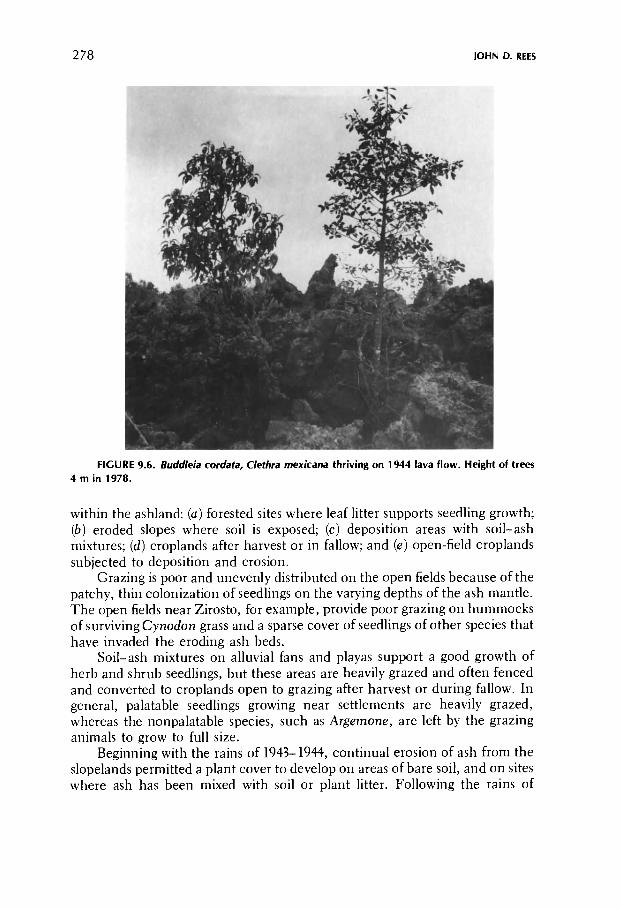
278 JOHN D. REES
FIGURE 9.6. Buddleia cordata, Clethra mexicana thriving on 1944 lava flow. Height of trees 4 m in 1978.
within the ashland: (a) forested sites where leaf Utter supports seedling growth; (b) eroded slopes where soil is exposed; (c) deposition areas with soil-ash mixtures; (d) croplands after harvest or in fallow; and (e) open-field croplands subjected to deposition and erosion.
Grazing is poor and unevenly distributed on the open fields because of the patchy, thin colonization of seedlings on the varying depths of the ash mantle. The open fields near Zirosto, for example, provide poor grazing on hummocks of surviving Cynodon grass and a sparse cover of seedlings of other species that have invaded the eroding ash beds.
Soil-ash mixtures on alluvial fans and playas support a good growth of herb and shrub seedlings, but these areas are heavily grazed and often fenced and converted to croplands open to grazing after harvest or during fallow. In general, palatable seedlings growing near settlements are heavily grazed, whereas the nonpalatable species, such as Argemone, are left by the grazing animals to grow to full size.
Beginning with the rains of 1943-1944, continual erosion of ash from the slopelands permitted a plant cover to develop on areas of bare soil, and on sites where ash has been mixed with soil or plant litter. Following the rains of

9. EFFECTS OF THE ERUPTION OF PARÍCUTIN VOLCANO 279
1943-1944, pastureland has been developing on sites near the volcano. However, forage production and animal capacity near the volcano are limited because large areas still retain an ash mantle. In addition, the 2480 ha of lava and cone represent a permanent loss of usable land.
The most heavily grazed sites are forested areas near villages where leaf litter supports seedling growth. On the more distant forested slopes of Tancitaro, the light grazing after 1943 and the greater retention of soil moisture resulting from the thin mantle of remaining ash allowed for a more luxuriant herb and grass cover. Grazing capacity was further augmented by timber felling on the slopes south of the volcano between Tancitaro and Cerro Prieto. Over 800 ha was cleared through the removal of timber on the communal lands of Paricutin and Parangaricutiro during the late 1940s and early 1950s. These clearings support a dense cover of annuals and grasses that is utilized for long-term pasturage in the fir forest zone; at lower elevations they serve for pasturage before, and after maize cultivation.
In the late 1940s, sizable numbers of sheep were herded on the lands of Angahuan and Paricutin. Sheep were purchased in nearby Corupo. Lack of funds encouraged the purchase of sheep rather than cattle. Also, sheep could get along on poorer forage than cattle. However, by 1965 the higher economic and prestige value of cattle, combined with the continuing improvement of forage as a result of increased plant cover, favored cattle grazing. People with little capital were now able to exploit forage resources on village communal lands by livestock production. In Caltzontzin, for example, several individuals each owned more than 100 cattle—many more than in 1945. In Caltzontzin, most of the cattle were pastured on Paricutin communal lands on the slopes of Tancitaro; the cattle population in 1965 was 2500 as against 450 in 1950.
In the mid-1950s, the raising of cattle yielded income not only from the sale of cattle in villages and market towns, but also from dairy products. Traditionally, milk is consumed only by children among the Tarascans. Since the mid-1950s, milk has been converted into cheese and sold in the market towns.
Cattle owned by the villagers on communal lands of Paricutin and San Juan Parangaricutiro are generally low-grade animals and have low milk production. These cows produce on the average of 4-5 liters of milk per day for a period of 2-3 months, whereas those owned by Tarascans in Cherán yield 8-12 liters per day for more than 7 months. Low milk production is caused by inadequate watering and nutrition. No supplementary grain or forage or water is supplied by the villagers to their cattle, even during droughts that occur in March and April. On top of all these setbacks, the distances and difficulties of transportation make the sale of fresh milk impractical even today.
Despite their low milk production, the Tarascan cattle are still highly prized as an easily salable, high-return speculative investment. Nonetheless, the primary importance of cattle continues to be in their value as work animals in agriculture.

280 JOHN D. REES
RECOVERY OF AGRICULTURE
Successful reestablishment of agriculture is closely related to conditions permitting survival, recovery, and reestablishment of native vegetation. Ash characteristics that inhibited native vegetation were detrimental to economic crops. As mentioned before, during the heavy cineric phase, maize seedlings near the cone were buried; those not buried died as a result of the infertility and droughtiness of the ash beds, and from fungus attacks through bruised tissues from windblown ash. Of all the negative factors, the lack of nutrients was by far the most important.
Pure ash devoid of vegetation had only 55 ppm of nitrogen at 2 cm of depth, as compared with 350 ppm in the underlying old soil. Ash with a pine-needle litter or supporting grass had higher nitrogen values (105 ppm) at surface levels, and lower values with increasing depth until true soil was reached (Eggler 1963:66). Farmers found that the nutrients in a thin layer of pine-needle litter plowed into pure ash were not sufficient to mature a maize crop.
Experiments carried out in the 1950s by agronomist Eduardo Limón (personal communication) showed that the ash must be heavily fertilized and continually supplied with nitrogenous materials to produce a maize crop. Enriching ash with commercial fertilizers seemed economically feasible only if the farmer were in a position to sell the maize grain, plow under all the remaining plants, and reinvest the sale proceeds in purchasing fertilizer for the next year. By the end of the third year, the enriched ash should be sufficient to sustain a maize crop without further fertilizing, although stubble should still be plowed under for ash enrichment. The entire process would require a capital outlay before the first crop was in; it presumed, therefore, that the farmer had sufficient resources to sustain his family for almost 3 years without having to rely on income from the farmland. In reality, the average Tarascan farmer did not have the money even to pay for the first year's fertilizers.
Fertilizing pure ash allows the farmer to produce a mature maize crop, but the yield is not sufficient to both feed the farmer and pay for fertilizer. On the other hand, fertilizing soil-ash mixture results in a dramatic increase in productivity that could provide subsistence for the farmer, plus crop surpluses to pay for fertihzer costs. Crop experiments in 1948 by Miller showed that traditional maize grown in fertilized soil-ash mixture on open field cropland at Angahuan yielded 2.025 metric tons of shelled grain per hectare when fertilized with a treatment of 40 kg Í and 40 kg P2O5 per hectare. This is in shaö contrast with the unfertilized plots that produced only 0.633 metric tons (896 liters) per hectare (Miller al. 1949:271). Miller's data indicate that the Angahuan plots were well suited for heavy fertilizing owing to the more than adequate rainfall during the critical months of maize growth and ear development (Miller et al. 1949:272).
Crop experiments by Tarascan farmers 20 years later in nearby San

9. EFFECTS OF THE ERUPTION OF PARÍCUTIN VOLCANO 281
Lorenzo showed that fertihzing soil-ash mixture yielded 2800 kg of maize per hectare. The 1700-kg increase over the usual 1080-kg yields sold for 1360 pesos, more than double the cost of fertilizing (Rees 1971:97). Unfortunately, effective use of commercial fertilizer, insecticides, and close planting did not begin to take place in the Itzicuaro Valley until as late as 1973.
In the absence of government technical support and funding for a commercial fertilization program. Limón suggested enriching the ash with the planting of two native herbs: one, Lupinus leucophyllus, a native legume, which failed to germinate properly in ash, and the other, Mirabilis jalapa, an herb with a large tuberous root, which succeeded. But Mirabilis was rejected by the Tarascan farmer as being a troublesome weed on maize lands.
The Tarascan farmer then attempted several approaches of his own: {a) the wholesale removal of ash by sluicing; (b) removal by bulldozing; (c) manual removal by digging of pits to reach old soil; (d) deep plowing by tractor; (e) furrow plowing on the ash mantle using animal traction, a wooden plow, and later, a steel plow. The first four approaches met with various difficulties; the last, furrow plowing, was successful.
The sluicing away of ash by directing floodwaters across the fields, used in experiments in Angahuan during the heavy cineric phase, resulted in deep gullying of the old soil, with high ridges of ash remaining. This technique has been little used since the mid-1940s. However, in 1978, at least one Angahuan farmer removed ash by canalizing storm runoff across a maize plot (Figure 9.7).
The bulldozing of the Angahuan fields by the government in 1953 initially cleared 25 ha of land but was discontinued because there were no satisfactory dumping sites for the ash spoil; ash dumped into ravines and water courses created problems downstream. The method of digging pits down to old soil and growing crops in them proved successful only on house lots. As early as 1945, maize, beans, and squash were produced on Angahuan house plots, but pit growing of crops was unsuited to open fields for three reasons: {a) labor and time required to dig and maintain the pits; (b) large dumping areas required to contain the ash spoil; and (c) filling of pits by wind- and rain-moved ash. The deep plowing of ash to bring soil to the surface was briefly tried near Zirosto in 1947 (Wilcox, personal communication). The effort was discontinued for reasons not known.
Furrow plowing, the sowing of maize in the old soil and soil-ash mixture, accounted for most of the productive acreage in the Itzicuaro Valley after 1945. Furrow plowing enables old soil, weeds, and crop stubble to be mixed into the ash mantle, thus providing some nitrogenous enrichment for each successive crop. The plowing of old soil into ash, however, does not guarantee the growth of maize evenly throughout a single field. Maize growth was uneven because of the differing depths of water-moved ash within a field. In many instances, plots with shallow ash produced harvested crops soon after the heavy cineric phase, whereas adjacent plots with deeper water-moved ash did not produce their first successful crop until 1960-1962, after a series of earlier

282 JOHN D. REES
FIGURE 9.7. Accelerated gully erosion created by deliberate canalization of runoff to remove ash. Angahuan, rainy season 1978.
failures. In general, most fields under furrow plowing with an ash depth of less than 15 cm were cropped as early as 1945; however, they did not come up to pre-eruption productivity until the mid-1960s.
Plowing using the traditional ox-drawn wooden plow limited successful maize growing to sites where true soil existed within 14 cm below the ash surface. Plowing with burros further limited cropping to where soil was found within 8 cm beneath the ash. The scarcity of cattle, compounded with the high prices for horses and mules and the lack of pasturage following the heavy cineric phase, all contributed to limiting the reclamation of land by the traditional wooden plow. The steel plow, which permits plowing to 22 cm of ash, was not in general use until the late 1940s, when forestry activities and earnings sent home by bracero workers made its purchase possible.
In areas of deep ash where the plow did not reach the old soil, two solutions were applied: {a) successive cropping, and (b) waiting until natural vegetation developed before applying the first plowing. With the first method, maize was seeded into pure ash where the lack of nutrients caused the seedlings to yellow and die; the field was then laid fallow for a year, and the procedure repeated until humus and weed growth provided sufficient nutrients to mature the maize plants. This, however, proved to be time-consuming.

9. EFFECTS OF THE ERUPTION OF PARÍCUTIN VOLCANO 283
painstaking, and costly in maize seed, and was therefore avoided by most farmers. The second method, waiting for the return of a natural pasture before applying the first plowing, required no active participation on the part of the farmer and was therefore preferred.
Some former cropping sites buried under ash cannot be easily reclaimed on account of the presence of a hummocky landscape that prevents plowing. On a site near Zirosto, for example, mounds were created by windblown ash caught and retained by the presence of Cynadon grass; ground between mounds was then lowered by channel and wind erosion, and the irregular surface thus formed made the reclamation of the cropping site difficult.
Most former cropping sites buried under 15-25 cm of initial ash deposition are presently under cultivation, with the exception of sties buried under water-transported ash. Many fields with an initial ash deposit of 25 cm were, by 1958-1962, eroded down to a remaining ash depth of 15 cm and were supporting a pasture reclaimed for crop growing during the same period. Fertility was often low during the initial years and many maize crops did not mature. Fallow periods of 2 or 3 years were common, and grain production was usually less than half of that in a contemporaneous forest clearing devoid of ash.
On sites where the initial ash deposition was between 25 and 50 cm, the recovery of crop growing vaires conspicuously from field to field, reflecting differences in either erosion, or enrichment of the ash with deposition of soil and organic material. By 1965, some plots were in the first years of cultivation, whereas others were still in the pasture stage. Over the years few farmers have attempted to enrich the ash by direct application of organic debris or animal fertiHzer. Direct enrichment of the ash with a small handful of animal manure placed with the maize seed at planting time was practiced by some farmers at Angahuan in 1978. Figure 9.8 shows a plot with 30 cm of remaining ash in the third year of maize cultivation; the first crop was planted in 1973. The fertilized plants are undernourished, resulting in undersized maize ears not satisfactory for dry grain but picked early to prepare atole (a corn soup). Adjacent unfer-tiUzed maize was stunted and failed to produce maize ears.
In areas where the former croplands received more than 50 cm of ash, the recovery of crop growing was limited to plots where the ash mantle had been removed, or where crops were sustained by soil and organic debris eroded from adjacent slopes. By 1978, maize sustained by eroded soil and organic debris grew on seven debris basin sites at the margins of the lava field. The first site cultivated was Choritiro (at the northeast edge of the lava field) in 1946; most other sites came into cultivation in the 1950s (Segerstrom 1961:D226). Generally, these sites are fertile enough to sustain cropping every other year without animal or chemical fertiHzer. The maize growing at Choritiro in September 1978 looked healthy and grew to 2 m. Unfortunately, the Choritiro site receives more runoff, sediment, and debris than desirable from the arroyo that drains a large area east of Angahuan. The runoff cut destructive swaths 4 to 15 m wide through the growing maize. Past construction of timber, rock, and brush walls have not controlled runoff at Choritiro as successfully as at the other sites.

284 JOHN D. REES
FIGURE 9.8. Maize on an ash playa 0.5 km southwest of Angahuan, 1978. Unfertilized plot at left, animal-manure enriched soil on right in third year of planting.
However, the proportion of crop lost to flooding is small. Productivity at Choritiro is described as a seed-to-harvest ratio of 1:45 (approximately equivalent to 0.630 metric tons per hectare).
Slopelands that were partially cleared of deeper ash by sheet, rill, and channel erosion saw a return to crop productivity as early as the spring of 1945. For example, the upper portion of the inclined open fields adjacent to Zacán was reclaimed in the mid-1940s because the initial ash deposition of 25 cm had already been eroded to a depth that permitted the plowing of old soil into the ash.
As a result of early crop failures on most of the open fields, crop growing has greatly expanded on the slopelands since the spring of 1945. Planting of maize was intensified on existing permanent fields, shifting cultivation sites, and pasturelands located on the slopes of Tancitaro and the Cerros of Angahuan (Figure 9.9). Most existing clearings were enlarged and new clearings created where sites could remain undetected by the federal foestry police. Most of these sites are located within communal forests (San Juan Parangaricutiro, Paricutin, Zirosto, Angahuan) where the initial ash deposition was shallow, and where erosion of ash was accelerated. Salvage lumbering and deforestation on the slopes of Tancitaro following the heavy cineric phase increased the

9. EFFECTS OF THE ERUPTION OF PARÍCUTIN VOLCANO 285
FIGURE 9.9. Partially deforested slopes near Angahuan supporting shifting cultivation and grazing. Alluvial fan partially reclaimed for maize cultivation. Eroded trail flanked by ash playa with Lupinus, Argemone, Epicampes, 1972.
availability of lands cleared for cropping. Almost continuous cropping of slope-land clearings has occurred since 1945, resulting, in many cases, in poor yields, shorter fallow periods, and severe erosion.
None of the pre-eruption cleared land covered by exposed lava (a total of 1370 ha) will ever be reclaimed. Unlike most of the ash mantle, the lava surface will not be cultivable for several thousand years. Most of the ash-covered cropland could have returned to pre-eruption productivity shortly after the heavy cineric phase (1943-1945) if subsoil plows drawn by tractors had been used. The subsoil plow is used in older irrigation districts in other areas of Mexico, and is capable of plowing to depths exceeding 1.8 m.
Reclamation has been speeded up recently because of changes in government policy and increased profitability in avocado production. Since 1973, government financing and technical support for reclamation of cropland has rapidly improved agriculture in Angahuan and Zirosto. The federal government has provided credit for chemical fertilizer to a group of 70 Angahuan farmers who are producing successful maize crops on soil-ash mixtures. The Michoacan State Forestry Commission has provided budded membrillo {Cydonia oblongata) and other fruit trees and technical aid to farmers wilHng to

286 JOHN D. REES
POSTERUPTION FORESTRY ACTIVITIES
Prior to the eruption, timber exploitation in the upper Itzicuaro Valley had always been on a small scale, with sales aimed at the village and local market, and usually not included in official statistics. From the beginning of the eruption, during the time when normal agriculture and grazing were arrested, villagers earned cash by greatly expanding the illegal cutting of dead and dying timber. Large quantities of firewood, charcoal, shingles, and hand-hewn and hand-sawn lumber and timbers were produced up to 1944, when large-scale lumbering and commercial milling were introduced to exploit timber devastated by ash. By 1954, the excessive cutting of timber brought commercial timber production to an end.
During and following the heavy cineric phase, firewood collection and oak charcoal production experienced an initial boom. The low prices of firewood limited its sale to local regions, but the government allowed large volumes of charcoal to be shipped to urban markets in other parts of Mexico. Today, firewood collection for sale to market towns is a minor activity. The ample supply of milling scrapwood from lumber mills in Uruapan has led to low firewood prices, and there is a reduction in market demand for firewood because of the shift to use of petroleum fuel by the major consumers in Uruapan—^the bakeries and the public baths. The long-distance hauling of firewood by burros from areas near the volcano has become the exclusive occupation of old men, since it pays less than the legal minimum wage. The production of oak charcoal, aimed exclusively at market towns, has continued on a much reduced scale since the 1940s. Market demand, however, remains constant in Uruapan despite the shift to bottled gas as cooking fuel, because charcoal is still being used by older residents and impoverished immigrants.
plant, protect, and care for trees planted on unreclaimed ash-covered fields where the ash is not deep. Some of the deeper ash sites are being reclaimed as the Forestry Commission encourages planting of well-developed pine seedlings provided without cost. By 1978 most pine planted on Angahuan lands appeared to be healthy and fast-growing.
A portion of the ash-covered fields of Zirosto now support avocado orchards. The federal government supervises contracts between village officials and outside private capital that leases the land and develops and operates the orchards using local labor. The villagers receive land rental income, wage income, and eventual ownership of the trees. The high profits from avocado production encouraged growers to pay the cost of creating soil-ash mixture for each tree, a heavy fertihzation program, and other development costs. Winter frosts will probably prevent the planting of avocados on the deeper ash areas of the higher elevations nearer to Paricutin. Without outside subsidy, the deeper ash areas will continue to remain uncultivated until plant succession enriches the ash with sufficient nutrients to mature a maize crop.
9. EFFECTS OF THE ERUPTION OF PARÍCUTIN VOLCANO 287
Presently, oak charcoal continues to be supplied from the forests of Angahuan and San Juan Parangaricutiro, where there is ample oak timber beyond the devastated zone.
During 1943 and 1944, an unusually large number of pine and fir shingles were produced for sale outside the devastated zone. Traditional hand-tooled lumber products such as beams and other squared timber were sold to outside buyers, usually to be milled later into small lumber. Today, a limited number of lumber products are made. Continued efforts are being made by the federal forestry officials to restrict timber exploitation to quantities consumed in each village. Timber cutting at Zacán, Zirosto, and Barranca Seca is now limited to production of lumber for village house construction. Beams, squared timber, and pine shingles, produced at Angahuan, are sold locally or to buyers from more distant markets, with or without official permission.
Carpentry that uses unseasoned pine and nails to make chairs, cabinets, and panel doors was a part-time activity of some individuals during the early years of the eruption. In 1965, full-time carpenters could be found in Caltzontzin, Nuevo San Juan, and Angahuan, and part-time caöenters in Zirosto, Barranca Seca, and Zacán. Cabinetry and furniture are the only products of wood that can be sold legally beyond the village without prior government permission. Carpentry items are sold locally and to market venders in Uruapan; however, lack of knowledge of marketing and of easy access to large trucks prevents furniture from being sold to Guadalajara or Mexico City, where prices are twice those of Uruapan.
The illegal cutting and selling of timber by villagers in 1943 and 1944 was allowed by federal forestry officials for fear of public criticism if laws against it were enforced. However, by 1944, villagers were required to apply for permits to cut timber. In this way, the first legal small-scale timber exploitation began to take place on the forest lands of Zirosto, San Juan Parangaricutiro, and Paricutin.
From 1944 to 1954, commercial lumber mills operated on the forest lands of Zirosto, San Juan Parangaricutiro, Paricutin, and Angahuan. Commercial lumbering was introduced when forestry officials decided to maximize utilization of salvaged timber. The wastefulness of using high-quality large-diameter pine for traditional shingle making encouraged the government to introduce commercial milling. Contracts were awarded to the Tarascan communal mill at San Felipe, and to non-Tarascan contractors to establish mills at Barranca Seca and Pantzingo (a hamlet located on the communal lands of San Juan Parangaricutiro) and to existing mills in Uruapan, Power sources at these mills varied from electricity to steam power to gasoline motors. Commercial lumbering increased the rate of cutting and salvaged huge volumes of damaged timber that would otherwise have decomposed and been wasted. It also permitted closer federal control over timber cutting and tax payments, and provided for payment for timber from communal forests to village communal funds.
In the initial phase of lumbering for the mills, hand-hewn squared timber was produced in the forest and converted into lumber at the mill. This proce-

288 JOHN D. REES
dure kept the villagers employed and diverted maximum income to the Tarascan laborers rather than to mill operators. However, timber squared with axes wastes too much wood in chips. Motor-driven saws are usually less wasteful. Therefore, government forestry officials decided to encourage the hand-tool production of logs and cants (short logs for boxwood) for later milHng into lumber at the mills. The mills made contracts with individual villages to purchase felled timber. Contracts specified payment of the felled timber to the communal fund of each village and payment to villagers working in the logging and milling operations. Wages paid to the Tarascan woodcutter were on a piecework basis; those paid to men working in road building, timber hauling, and milling were on a fixed daily-wage basis. Income to the village communal funds, believed to have amounted to over U.S. $200,000, was held in trust by the federal government and helped to pay for resettlement—^as in the case of Barranca Seca—and for general improvements, such as electricity and piped water in all the villages.
From 1944 to 1954, men from Zirosto, Miguel Silva, Neuvo San Juan, Caltzontzin, and Angahuan alternated from crop growing on their own fields to lumber operations to contract farm labor in the United States. The men of Zacán, not involved in commercial lumbering, farmed on their own reclaimed fields or migrated as harvest laborers to the United States or to other parts of Mexico.
By 1954, most of the devastated timber had been removed. Federal forestry officials were aware that much live timber was being illegally cut on the communal lands of Zirosto; permission to cut timber was withdrawn and commercial lumbering in the Itzicuaro Valley came to an end.
Resin production, traditionally a secondary occupation for most farmers, came to a complete halt during the heavy cineric phase because falling ash polluted the bleeding faces of the pine, as well as the collection cups. Resin production was resumed when the ashfall subsided. Ash-polluted pine was bled for resin as early as 1946 on private holdings of residents of San Juan Parangaricutiro. Production on communal lands was delayed because wages paid to resin collectors were low as compared with lumbering wages and wages paid for harvest outside the region. By the mid-1950s, the government renewed or approved new contracts with existing turpentine distilleries in Uruapan, and the acreage in pine resin production steadily increased. By the mid-1960s, more men were employed in resin collection than in any other forest activity. Most men in Zirosto, Zacán, Barranca Seca, and Angahuan supplemented their income by working approximately 6 days per month in resin collection. The majority of men possessed collection rights averaging between 200 and 500 trees; a few had rights to 1000 or over. Each tree yielded between 3 and 5 kg of resin annually. Government further stimulated production by establishing a government-sponsored cooperative turpentine distillery in the Tarascan village of Cherán. In 1968, the Cherán distillery paid members of its resin collection cooperative one peso per kilo, whereas privately owned distilleries were paying only 45-67 centavos per kilo.

9. EFFECTS OF THE ERUPTION OF PARÍCUTIN VOLCANO 289
SUMMARY A N D CONCLUSION
The Paricutin eruption created a cinder cone that rises 200 m above the surrounding lava field. Beyond the lava field, the landscape was covered by volcanic ash that varied in depth from 11m near the cone to 25 cm at Angahuan 7 km distant. Accelerated erosion has transported much of the ash from slopes to basins and alluvial fans, or onto the floodplains of the lower Itzicuaro Valley. The lava blocked prior drainage, and in areas of gentle terrain created large lake basins that filled with eroded ash and debris. Upslope from the lava field, isolated pre-eruption basins also became filled with ash and debris. Floodwaters that flowed out of these basins cut barrancas and created a new drainage system that connects with the intermittent streams on the border of the lava field. Vegetation was totally killed under the cinder and lava and in areas of deep ash. Grazing and agriculture were devastated during the heavy ashfalls of 1943.
The heavy ashfalls of 1943 forced the majority of residents of Zirosto to migrate to Miguel Silva, a distant resettlement site, or to other Tarascan villages. Soon after, many of the former residents from Zirosto returned to work in salvage lumbering at Barranca Seca. When additional lands were provided by the government. Barranca Seca was transformed into Zirosto Nuevo. The former residents of Zacán returned to reclaim their ash-eroded land as early as 1945. Angahuan alone remained intact during the ashfall. Sustained by its more distant forests and croplands, Angahuan's economy was further augmented by tourist income following the eruption. The invasion of lava over the villages of Paricutin and San Juan Parangaricutiro in 1944 forced the inhabitants to relocate permanently at Caltzontzin and San Juan Nuevo outside the Itzicuaro Valley.
Although the croplands at Nuevo San Juan are limited, the relocated residents remained there permanently on account of the ample undevastated communal and private lands stretching to within 2 km of the new village. The income that Nuevo San Juan derives from crops, grazing, and forestry is further augmented by tourist income from the annual pilgrimage to the Miraculous Image of Christ.
Most of the former residents of Paricutin remained permanently at Caltzontzin. The croplands at Caltzontzin produce sufficient maize to keep
The recovery of the pine forests and the higher price for resin account for the present success of resin activities. Unfortunately, the quest for resin income has resulted in poor management of young pine stands. Crowding and poor nutrition produce narrow crowns and small-diameter trunks—the poorest characteristics for resin production. Many of these trees are under 20 cm in diameter at breast height and show three bleeding faces. The exploitation of premature young pines will ultimately result in reduced resin yields and lowered quality of wood as a whole for use as lumber.

290 JOHN D. REES
the population from leaving, but supplementary income is necessary for most families. Most men are forced to do harvest work outside the village or work as unskilled laborers in nearby Uruapan. Some families return for days to months to hamlets on Paricutin communal lands to work in forestry, cheese production, and maize cultivation on forest clearings. As a result, the resident population fluctuates seasonally at the hamlets of La Escondida, San Salvador Teruto, and La Capilla, located south of the Paricutin cone.
With the direct intervention of the outside world, the resettlement villages were modernized 10-20 years ahead of other Tarascan villages in the Meseta Terasca. The government introduced water storage and piping installations, electricity, medical clinics, and poultry-raising projects into the resettlement villages. Traditional village communal funds, enriched by salvage lumbering, were channeled into financing these improvements and encouraged cottage industry that produced hand-woven cotton textiles, cabinetry, leather sandals, fired bricks, etc. With the exception of cotton textiles at Caltzontzin, most of these enteörises failed through insufficient technical training and generally low quality of the products.
As conditions stand now, the upper Itzicuaro Valley has not yet recovered from the Paricutin eruption. A delayed vegetation succession is slowly taking place on the ash playas and the lava and cone surfaces. With time, the lava field should develop into a humid blocky lava malpais subtype of pine-oak forest, such as that found on the geologically recent Capacuaro flows. The ash playas and cone surfaces can be expected to weather to productive soils more rapidly than the lava, but excessive drainage on the cone, insufficient nutrients, and overgrazing will inhibit a rapid colonization and succession to a pine-oak forest with a balanced species composition similar to pre-eruption times. Distance to seed sources, and the stripping away of humus-rich soil, will retard the return of the broadleaf subtropical forest to more humid barranca environments.
Resin production has become the most important type of forest exploitation since the eruption ended; it will continue to be important if resin prices remain subsidized by the government. Timber cutting by individual villagers will continue on a small scale, as in pre-eruption times. However, because of excessive posteruption cutting and smaller-diameter class size of pines grown, it is unlikely that large-scale privately owned lumber mills will return to the valley in the near future. The smaller-diameter pines, however, are being used for boxwood production in Capacuaro. Pine timber will continue to be used by villagers for carpentry and for clandestine production of common lumber for village construction and outside sale.
Grazing conditions remain poor on the barren ash playas, but forested hill slopes and more distant sites support cattle grazing. Forage conditions will improve as ash and soil-ash mixture continue to be colonized by plants. Overgrazing, however, will delay recovery of vegetation on sites near settlements.
Changes in agricultural productivity are just beginning. In the early 1970s some of the wealthier villagers began experimenting on their best lands with

9. EFFECTS OF THE ERUPTION OF PARÍCUTIN VOLCANO 291
REFERENCES
Arias Portillo, P. 1945 La region devastada por el Volcαn de Paricutin. Thesis presented for the title of Ag
ronomist, specialist in Forestry, Escuela Nacional de Agricultura, Chapingo, Mexico. Beaman, J. H.
1960 Vascular plants on the cinder cone of Paricutin Volcano in 1958. Rhodora 62:175-186. 1961 Vascular plants on the cinder cone of Paricutin Volcano in 1960. Rhodora 63:340-344.
Bullard, F. M. 1976 Volcanoes of the earth. Austin: University of Texas Press.
Eggler, W. A. 1948 Plant communit ies in the vicinity of the Volcano El Paricutin, Mexico, after two and a
half years of eruption. Ecology 29:415-436. 1959 Manner of invasion of volcanic deposits by plants with further evidence from Paricutin
and Jorullo. Ecological Monographs 29:268-284. 1963 Plant life of Paricutin Volcano, Mexico, eight years after activity ceased. American
Midland Naturalist 69:38-68.
inexpensive chemical fertilizers on traditional maize varieties, resulting in the triple yields that more than cover the cost of fertilizing. In the 1960s budded fruit trees—^peach, pear, and apple—obtained from the Forestry Commission of the state of Michoacan, were planted on a few house-lot gardens; but most were neglected and few survive for lack of pruning, fertilizer, and of insect, gopher, and fungus abatement.
Agricultural production could have been in operation earlier if technical assistance and credits for fertilizers and fruit trees had been available and insect and gopher pests put under control by chemicals. The still prevalent resistance to fertilizing and hybrid maize, augmented by lack of experience in efficient production and sale of market crops, hinders the full use of existing farmlands. It may be years before the farmers will shift from subsistence production of maize to market production of cabbage, potatoes, and carrots—crops that do well in the region and have a ready market in the cities. Presently, for instance, potatoes are earning substantial profits for Tarascans at Cherán outside the valley, where technical assistance is available and where potatoes and cabbage have found a market in Guadalajara.
Since 1973, government financing and technical support has accelerated reclamation of cropland in the Itzicuaro Valley. At Angahuan, ash playas are being transformed into orchards and small pine plantations. Credits for chemical fertilizer have raised maize yields. Outside capital is transforming Zirosto ash playas into avocado orchards.
Most pre-eruption cleared lands are lost to cropping where buried under 50 cm or more of ash (2790 ha); exceptions are those sites with soil-ash mixture or where sites are eroded down to original soil. Long-term loss of pre-eruption cleared lands—^those under cultivation, in annual fallow, in long fallow with shifting cultivation—^amounts to approximately 4160 ha. Of these, over 1374 are under lava and will remain totally uncultivable for thousands of years.

292 JOHN D. REES
Foshag, W. F. and Jenaro Gonzαlez R. 1956 Birth and development of Paricutin Volcano, Mexico. Geological Survey Bulletin %5-D.
Washington, D .C. : U.S . Government Printing Office. Fries, C. Jr.
1953 Volumes and weights of pyroclastic material, lava, and water erupted by Paricutin Volcano, Michoacαn, Mexico. Transactions, American Geophysical Union 34:603-616.
Gutiιrrez, C. 1972 A narrative of human response to natural disaster; T h e eruption of Paricutin. In San Juan
Nuevo Parangaricutiro: Memones of past years, edited by Mary Lee Nolan. Environmental Quality Note No . 6. College Station: Texas A & Μ University.
Hatt, R. T. 1948 A bibliography of Paricutin Volcano. Papers of the Michigan Academy of Science, Arts,
and Utters 34:227-237. Macdonald, G. A.
1975 Hazards from volcanoes. In Geological hazards, by B. A. Bolt, W. L. Horn, G. A. Macdonald, and R. F. Scott. New York. Springer-Verlag.
Madrigal Sanchez , X. 1964 Contribuciσn al conocimiento de la ecologia de los bosques de Oyamel (Abies Religiosa Η.
Β. Κ.) en el Valle de Mexico. Thesis presented for the title of Biologist, Escuela Nacional de Ciencias Biolσgicas, Instituto Polytechnico Nacional , Mexico D. C.
Miller, Ε. Β., J. Β. Pitner, Ricardo Villa J., Carlos Romo G. 1949 Population density of unirrigated maize and its influence upon fertilizer efficiency in
central Mexico. Soz7 Science Society of America, Proceedings 14:270-275. Nolan, M. L.
1972 T h e towns of the Volcano: A study of the human consequences of the eruption of Paricutin Volcano. Doctoral dissertation. Dept. of Geography, Texas A & Μ University.
O r d o n e z , E . 1947 El Volcαn de Paricutin. Mexico: Editorial Fantasia.
Poli, Ε . , and Valerio Giacomini 1970 Vulkane and pflanzenleben. In Vulkane, edited by Christoph Kruger. Vienna: Anton
Schroll & Co. Rees, J. D .
1961 Changes in Tarascan settlement and e c o n o m y related to the eruption of Paricutin. Master's thesis. Dept. of Geography, University of California, Los Angeles.
1970 Paricutin revisisted: A review of man's attempts to adapt to ecological changes resulting from volcanic catastrophe. Geoforum 4:7-25.
1971 Forest utilization by Tarascan agriculturists in Michoacαn, Mexico. Doctoral dissertation. Dept. of Geography, University of California, Los Angeles.
Segerstrom, Κ. 1950 Erosion studies at Paricutin. Geological Survey Bulletin 965-A. Washington D . C . : Gov-
erment Printing Office. 1960 Erosion and related phenomena at Paricutin in 1957. Geological Survey Bulletin 1104-A.
Washington D.C. : U.S . Government Printing Office. 1961 Deceleration of erosion at Paricutin, Mexico. Article 370 in U .S . Geological Survey
Professional Paper 424D. Washington D .C . : U .S . Government Printing Office. 1966 Paricutin, 1965—Aftermath of eruption. U . S . Geological Survey Professional Paper
550-C. Washington D .C . : U .S . Government Printing Office. West, R. C.
1948 Cultural geography of the modern Tarascan area. Smithsonian Institution. Institute of Social Anthropology No . 7.
Wilcox, R. E. 1954 Petrology of Paricutin Volcano, Mexico. Geological Survey Bulletin 965-C. Washington
D . C . : U.S . Government Printing Office. Williams, H.
1950 Volcanoes of the Paricutin Region, Mexico. Geological Survey Bulletin 965-B. Washington D .C. : U .S . Government Printing Office.


![Landforms Mady By Wind [Desert Landforms]](https://img.pdfslide.us/doc/110x75/56813971550346895da1066c/landforms-mady-by-wind-desert-landforms.jpg)