Embed Size (px)
Citation preview

19
Ef fect of drip irrigation w ith saline water on the constr uction of shelterbelts for soil and
groundwater protection in the hinterland of the Taklimakan Desert , China
• Jinglong Fan*# ●Xinjiang Institute of Ecology and Geography Chinese Academy of Sciences
#These author contributed equally to this work
*Corresponding author
● Yaping Wei ●Xinjiang Institute of Ecology and Geography, Chinese Academy of Sciences/University of
Chinese Academy of Sciences
● Xinwen Xu# ●Xinjiang Institute of Ecology and Geography Chinese Academy of Sciences
#This author contributed to this work equally with the corresponding author
● Xinghu Yang ●Xinjiang Institute of Ecology and Geography, Chinese Academy of Sciences/University of
Chinese Academy of Sciences
Abstract
Fan, J., Wei, Y., Xinwen, W., & Yang, X. (March-April, 2017). Effect of drip irrigation with saline water on the construction of shelterbelts for soil and groundwater protection in the hinterland of the Taklimakan Desert, China. Water Technology and Sciences (in Spanish), 8(2), 19-30.
In order to perceive the effect of drip irrigation with saline water in the desert hinterland on plant growth of shelterbelts and underground environment (vadose zone and groundwater), by developing water-saving irrigation technology to ensure the scientifically substantiated utilization of water resources, four different irrigation cycle experiments (difference in irrigation period I: 12d; IV: 25d; II & III: 25d in the summer and the respective spring and autumn periods, which were the same: 15d and 20d, respectively) were carried out during the irrigation season in four different regions of well irrigation area. In this paper, regular on-site investigation was adopted to observe soil, water, and salt. Single-factor analysis of variance and least significant difference (LSD) are used to analyze the data acquired by the survey method and for measuring plant growth, complemented with the comparison of groundwater level and chemical index before and after irrigation. The results showed that the reduction of annual irrigation volume from 420 mm to 201.6 mm had almost no effect on plant growth and could save more than 50% of the water as compared to treatment I. Considering the impact on the height-growth of Tamarix, treatment II could be optimized, so that more than 30% of the water could be saved as compared to treatment I. Three days after irrigation, the salt was leached through
ISSN 0187-8336 • Tecnología y Ciencias del Agua, vol. VIII, núm. 2, marzo-abril de 2017, pp. 19-30
Resumen
Fan, J., Wei, Y., Xinwen, W., & Yang, X (marzo-abril, 2017). Efecto del riego por goteo con agua salina en la construcción de cortinas rompevientos para protección del suelo y las aguas subterráneas en el interior del desierto de Taklimakan, China. Tecnología y Ciencias del Agua, 8(2), 19-30.
Con la finalidad de entender el efecto del riego por goteo con agua salina en el crecimiento de plantas de cortinas rompevientos y en el ambiente subterráneo del interior del desierto (zona no saturada y aguas subterráneas), mediante el desarrollo de tecnología de riego para asegurar el aprovechamiento científicamente justificado de los recursos hídricos, se efectuaron cuatro experimentos de riego en ciclo de ahorro de agua (diferencia en periodo de riego I: 12d; IV: 25d; II y III: 25d en verano; sus respectivos periodos de primavera y otoño fueron los mismos: de 15 d y 20 d, respectivamente) durante la temporada de riego en cuatro diferentes regiones del área de riego con agua de pozo. En este trabajo se adoptó la investigación regular in situ para observar suelo, agua y salinidad. Se utiliza el análisis de varianza de un solo factor y la diferencia mínima significativa (LSD) para analizar los datos obtenidos por el método de encuesta y para medir el crecimiento de las plantas; complementando lo anterior con la comparación de nivel de agua subterránea y el índice químico antes y después del riego. Los resultados mostraron que la reducción de volumen de riego anual de 420 a 201.6 mm casi no tuvo efecto en el crecimiento de las plantas, y podría ahorrar más del 50% de agua, en comparación con el tratamiento I. Si se considera el impacto en el crecimiento de altura de Tamarix, el tratamiento II podría ser optimizado, por lo que se podría ahorrar más de un 30% del agua, en comparación con el tratamiento I. Tres días después del riego, la sal se lixivia a través del cuerpo del suelo a las aguas subterráneas;
20
Tecn
olog
ía y
Cie
ncia
s del
Agu
a, v
ol. V
III,
núm
. 2, m
arzo
-abr
il de
201
7, p
p. 1
9-30
Fan et al., Effect of drip irrigation with saline water on the shelterbelts to soil and groundwater environment in the hinterland of Taklimakan Desert, China
• ISSN 0187-8336
Introduction
In the arid and semi-arid regions of China, many hydrological changes have occurred due to the impact of climate change and human activities (Zhao & Cheng, 2002; Huang & Pang, 2010), particularly the irrigation projects with use of groundwater. Groundwater in the arid areas plays an important role in ensuring the stability of the desert and oasis ecosystem (Na-umburg, Mata-Gonzalez, Hunter, Mclendon, & Martin, 2005; Mu Oz-Reinoso, 2001; Gullison & Bourque, 2001). Tarim Desert Highway shelter-belt ecological engineering project is the longest artificial shelterbelt system crossing drifting desert. It has been completed 436 km protec-tion forest in the Taklimakan desert, sometimes known as “the green corridor”. Groundwater resources in the desert region are very precious, and various environmental problems could arise without optimal use and effective conservation (Zhang, 2004). One of the most pertinent issues in achieving water saving irrigation is to study the formation and movement pattern of water in the vadose zone. The thickness of vadose zone along desert highway is different, and the irriga-tion system for shelterbelts is the same, which is conducive to the convenient management of water resources, but is also an indirect waste of groundwater resources (Han, Cao, Yimit, Xu, & Zhang, 2012). Currently, there have been few
reports on the effect of irrigation with saline water on the growth of artificial forest and groundwater environment (Li, Lei, Zhao, Xu, & Li, 2015; Zhang, 2016). These studies not only help deepen the scientific insight into the SPAC (soil-plant-atmosphere continuum) (Shaozhong, 1994), but also have important guiding signifi-cance for groundwater pollution control as well as ecological and environmental engineering projects (Guswa, Celia, & Rodriguez-Iturbe, 2002; Scott, 2001).
The volume of irrigation water and the salt distribution in soil profile can affect the salt leaching process (Swarajyalakshmi, Gurumur-thy, & Subbaiah, 2003), so the soil salt dynamics has been extensively explored (Xu, Li, & Wang, 2006; Zhou, Xu, Lei, & Li, 2006; Miyamoto, Chacon, Hossain, & Martinez, 2005; Mousavi, Soltani-Gerdefaramarzi, & Mostafazadeh-Fard, 2010). However, most of the laboratory studies were focused on the effect of water and soil properties on the response to irrigation, while there is scarce information on the impact of drip irrigation with saline water on the growth, soil, and groundwater of Tamarixramosissima and Haloxylonammodendron forests under desert environment. Therefore, the purpose of this study is to evaluate the impact of drip irrigation with saline water on plant growth in shelterbelts and underground environment in the study area under natural conditions. In this study, four
Received: 14/01/2016Approved: 26/10/2016
the soil body into the groundwater. The groundwater level in the shelterbelt area, total dissolved solids (TDS), and total hardness exhibited an upward trend. Six days after irrigation, the high salt concentration region was found at a depth of 0–30 cm.
Keywords: Drip irrigation with saline water, shelterbelts, vadose zone, groundwater, Taklamakan Desert.
el nivel de agua subterránea en el área de la cortina rompevientos, los sólidos disueltos totales (SDT) y la dureza total mostraron una tendencia ascendente. Seis días después del riego, la región de alta concentración de sales se encontró a una profundidad de 0 a 30 centímetros.
Palabras clave: riego por goteo con agua salina, cortina rompevientos, zona no saturada, aguas subterráneas, desierto de Taklamakan.

21
Tecn
olog
ía y
Cie
ncia
s del
Agu
a, v
ol. V
III,
núm
. 2, m
arzo
-abr
il de
201
7, p
p. 1
9-30
Fan et al., Effect of drip irrigation with saline water on the shelterbelts to soil and groundwater environment in the hinterland of Taklimakan Desert, China
ISSN 0187-8336 •
irrigation experiments with different water treatments were set up in which water volume decreased gradually, and the cross-sectional distribution of water and salt for each treatment and ultimate impact on the groundwater envi-ronment were analyzed. Finally, an approach for water conservation and the observed differences between various treatments were described.
Experimental
Study area
The Taklimakan desert is the largest desert in China, at the same time, is the world’s second-largest drifting desert, and covers an area of 33.7 square kilometers (Sun & Liu, 2006). It is located in the center of Tarim basin in northwest China. This basin is a major area for producing oil and gas resources in China. The Tarim Desert Highway crosses the Taklimakan desert from south to north. The shelterbelt forests were built on both sides of the highway with the width of 72-78m. Due to the distance of the road across, the drifting desert is the longest in the world (Alles, 2012), so it is listed in the Guinness Book of Records.
From north to south, Tarim Desert Highway sequentially crosses five major geomorphic units-compound transverse dune area, dome-shaped dune area, high compound longitudinal dune area, compound longitudinal dune area, and compound transverse dune area (Lei et al., 2008). The study area is located in a dome-shaped dune area and the geomorphic unit has a total length of about 20 km, and the ground-water level is generally around 2 m. The water supply for the shelterbelt is basically ground-water with total dissolved solids (TDS) was 4.138 g/l and pH value is 7.21. The main pipe was used to convey the water from the ground while the branch pipe diverted the water with drippers installed on the drip tube for irrigation. The Aeolian sandy soil is fine sand, the soil bulk density of peripheral plantations is 1.43 g/cm3, and the soil porosity is 45.55%.
Test design
In order to effectively use the groundwater characteristics of the regions with relatively rich groundwater resources and to achieve water-saving irrigation, three additional water supply schemes for conservation of water resources were proposed based on the original irrigation system for shelterbelt project. As shown in figure 1, the entire shelterbelt land irrigated by well water was divided into four regions: region I with the existing irrigation system and regions II, III, and IV with modified irrigation systems for the comparison with region I (table 1).
Since the Tarim Desert Highway Ecological Shelterbelt Project completion in 2005, the an-nual irrigation cycle from March to October was used for the shelterbelt. Under the condition of sufficient water resources for the spring and autumn irrigations, the above irrigation period was elongated, so that plants were under water stress compared to the original irrigation sys-tem. The growth of plants in different regions was monitored, in order to achieve effective wa-ter conservation without affecting plant growth. The specific experimental design is shown in table 1.
The data in table 1 are calculated as follows
Annual irrigation times (WIT):
WIT =90WIP1
+90WIP2
+60WIP3
(1)
Irrigation water (WIW):
WIW =WIT 6 3.5 10 3 (2)
Water conservation rate (WCR). We set irrigation treatment I’ for WIW = WIWCK:
Then:
WCR =
WIWCK WIW _n
WIWCK
(3)

22
Tecn
olog
ía y
Cie
ncia
s del
Agu
a, v
ol. V
III,
núm
. 2, m
arzo
-abr
il de
201
7, p
p. 1
9-30
Fan et al., Effect of drip irrigation with saline water on the shelterbelts to soil and groundwater environment in the hinterland of Taklimakan Desert, China
• ISSN 0187-8336
Here the number of days with irrigation is 240 from March to October. The water volume that drips out of emitters is 3.5 × 10⁻³ m3 per hour. The control area of the drip water emitter is 1 m2. The single irrigation time is 6 hours per emitter. WIP is irrigation period/interval, WIP_1,
WIP_2,WIP_3 are March to May, June to August, and September to October irrigation periods, respectively; n is II, III, IV.
Measurement and analysis
The effect that saline water irrigation to the groundwater was observed by four wells from the emitter every 30 cm called 1, 2, 3, 4, and set a control check (CK) observation well in bare sandy land around 100 meters away (figure 1). It reflected cumulative-change values by subtract-ing groundwater level and chemical indicators (TDS, pH, total alkalinity & total hardness) before the irrigation from the corresponding value after irrigation, where TDS were tested by using the 180 ºC drying weight method (APHA-AWWA-WEF, 1998). Measurement of pH was performed using a pH meter (Model PHS-3C, Shanghai Lici Ltd., China). Total alkalinity was determined by titration with acid (Larocque et al., 2016). Total hardness was determined by an EDTA complexometry.
The effect of the irrigation to the groundwa-ter level was observed every day in an irrigation period 12d. It measured by releasing a probe connected with a multimeter by dual-cable wire into the well pipe. The multimeter was switched to the resistance shift. When the probe touched the water table, the cable was marked
at the height of the well head, and the distance between the mark and the probe was measured after retrieval. The subtraction of the nth water table observation Hn data from the initial obser-vation data H0 gave the relative water level at the nth observation (H0−Hn) to each observation wells.
Seedling investigation method was used for shelterbelts trees during the whole growing season, ten representative plants were randomly selected by human from Tamarixramosissima and Haloxylonammodendron respectively, and three indicators of plant height, crown width, and diameter at the ground level were measured. The One-Way ANOVA and least significant dif-ference (LSD) method were used to analyze the influence of irrigation water for plant growth using SAS statistical software (version 9.1, SAS Institute Inc.).
Regular on-site investigation method was adopted to observe the soil salt in the experi-ment area on 1d, 6d, and 9d after irrigation. Soil electrical conductivity (EC) exhibiting a linear relationship with soil salinity within the study area (Wang, Xu, Lei, Li, & Wang, 2010), the respective EC value was measured, in order to assess the soil salinity, by a SY-3 conductivity-thermometer (Institute of Soil Science, Chinese Academy of Sciences, 1987) with the weight of water: soil = 5:1 (Han, Cao, Yimit, Xu, & Zhang, 2012). The soil samples were collected at depths of 0, 5, 15, 25, 35, 55, 75 and 95 cm under the emitter with the horizontal distances of 0 to 150 cm every 30 cm from the emitter. Three samples per each fixed point were used to measure EC.
Table 1. Experimental design for different irrigation treatments.
Irrigation treatment
Irrigation time/h
Irrigation period/dWIT WIW/mm WCR/%
Mar.- May. Jun. - Aug. Sep.- Oct.
I 6 12 12 12 20 420.0 -
II 6 15 25 15 13.6 285.6 32.0
III 6 20 25 20 11.1 233.1 44.5
IV 6 25 25 25 9.6 201.6 52.0

23
Tecn
olog
ía y
Cie
ncia
s del
Agu
a, v
ol. V
III,
núm
. 2, m
arzo
-abr
il de
201
7, p
p. 1
9-30
Fan et al., Effect of drip irrigation with saline water on the shelterbelts to soil and groundwater environment in the hinterland of Taklimakan Desert, China
ISSN 0187-8336 •
In each experimental area, a 2 m long Soil moisture observation tube was embedded into soil under emittter made of aluminum/plastic composite pipe of 50 mm in diameter. Soil mois-ture was determined via neutron probes (Gard-ner & Kirkham, 1952) with five replicates after irrigation, then the mean value of replications was used as the soil water content. This rapid, in situ, nondestructive means of measuring soil moisture profiles in forestry (Wells & Fityus, 2011) was used in this work to determine soil moisture at 10-cm intervals from the soil surface to a depth of 180 cm.
Results and discussion
Spatial distribution of soil water and salt under different irrigation conditions
Water spatial distribution
Four different irrigation cycle experiments during irrigation season were carried out in four different regions of well irrigation area (table 1). According to figure 2, after the irriga-tion, the soil water content in region I with the original irrigation system reached saturation at
Figure 1. Schematic diagram of the experimental layout.

24
Tecn
olog
ía y
Cie
ncia
s del
Agu
a, v
ol. V
III,
núm
. 2, m
arzo
-abr
il de
201
7, p
p. 1
9-30
Fan et al., Effect of drip irrigation with saline water on the shelterbelts to soil and groundwater environment in the hinterland of Taklimakan Desert, China
• ISSN 0187-8336
a depth of 100 cm, while the soil water content in regions III, II, and IV reached saturation at depths of 160, 180, and 160 cm, respectively. Due to the shallow groundwater in the entire irrigation area, an aquifer is present within 180 cm soil depth, while the groundwater depths of four irrigated areas were different. The shallow-est and the deepest groundwater depths were found in regions I and IV, respectively, with a gap of about 60 cm. Therefore, irrigation has a relatively high impact on the surface soil water, but a feeble one on deep soil water; the soil water content of each region can be maintained at a high level with the soil porosity of 45.55%.
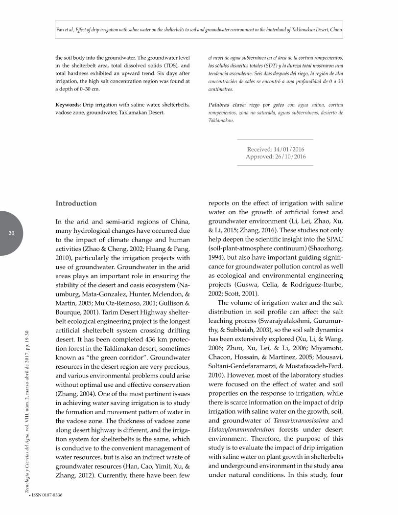
Salt temporal change Since shelterbelt plants have high tolerance to soil salinity, plant could grow normally under various irrigation systems, and soil salinity
increases from spring to autumn (Huang et al., 2015). Due to multiple repeated irrigation cycles, salts dissolved in irrigation water may increase soil salinity, resulting in a salinity level higher than that tolerated by the plant (Zhang et al., 2008), so understanding of the patterns of the salt migration and accumulation is very important. For example, the pattern in salt mi-gration of region I was studied by continuous salinity monitoring within the irrigation cycle. As shown in figure 3(b), 3d after irrigation, the total soil salinity was significantly reduced, as compared to that in figure 3(a) and there was no significant salt accumulation. Most of the salt was infiltrated with the soil water from the range defined by the dashed line in figure 3(a) (i.e. the range from the surface to 20 cm) through the vadose zone into groundwater body. As can be seen from figure 3(c), over the course of evaporation and water redistribution, the salt
Figure 2. Differences in the soil water content under different irrigation treatments.
25
Tecn
olog
ía y
Cie
ncia
s del
Agu
a, v
ol. V
III,
núm
. 2, m
arzo
-abr
il de
201
7, p
p. 1
9-30
Fan et al., Effect of drip irrigation with saline water on the shelterbelts to soil and groundwater environment in the hinterland of Taklimakan Desert, China
ISSN 0187-8336 •
ance was used to analyze the data from statisti-cal experiments, and the respective results are presented in table 2.
The comparative analysis of the above re-sults revealed no significant differences on all indicators of various treatments, except for plant height of Tamarixramosissima. This indicates that various irrigation systems have no significant effect on plant growth. The plant height differ-ence for Tamarixramosissima can be assessed us-ing the multiple comparison procedure among groups, which yields the results as shown in table 3. As can be seen, no significant difference was found between regions I and II, while there were differences found between region I and region III or region IV at the significance level of 5%. At a high significance level of 1%, there were differences between regions I and III.
gradually moved from the lower layer to the upper one in the vadose zone, and was accu-mulated in a depth range from 0~25 cm (dotted line) on day 9. Figure 3(d) shows that salt was continuously accumulated in the surface soil body at a horizontal distance of 20-140 cm from the dripper and a depth of about 20 cm.
Differences in plant growth under various irrigation volumes
With the survey method for shelterbelt tree seed-lings, ten representative plants were randomly selected for the measurement of plant height, crown width, and diameter at the ground level. These characterization parameters are used to reflect the impact of different irrigation systems on plant growth. Single-factor analysis of vari-
Figure 3. Soil salt migration process within the irrigation cycle (a) Isoline of soil electrical conductivity one day after irrigation; (b) Isoline of soil electrical conductivity three days after irrigation; (c) Isoline of soil electrical conductivity six days after
irrigation; (d) Isoline of soil electrical conductivity nine days after irrigation.
26
Tecn
olog
ía y
Cie
ncia
s del
Agu
a, v
ol. V
III,
núm
. 2, m
arzo
-abr
il de
201
7, p
p. 1
9-30
Fan et al., Effect of drip irrigation with saline water on the shelterbelts to soil and groundwater environment in the hinterland of Taklimakan Desert, China
• ISSN 0187-8336
Impact on groundwater
Groundwater level
The values of the groundwater level changes at different observation wells during each ir-rigation period were obtained by subtracting the groundwater level after irrigation from the groundwater level before irrigation (figure 4). According to the changes in the groundwater level at different observation wells, the water levels in the four groundwater observation wells in the shelterbelt area showed an upward trend. The highest water level at No. 1 observa-tion well was reached on day 10, and the highest water levels at the remaining three observation wells were reached on day 9. On the other hand, no obvious change pattern was found in the groundwater level in the observation well CK that was located in the original sands outside of the shelterbelt. According to observational data, the largest and the smallest rises of water levels were 0.022 m (No. 3 observation well) and 0.001 m (No. 1 observation well), respectively,
indicating that irrigation can raise groundwater levels, but this effect is feeble, resulting only in few centimeter changes.
Groundwater chemistry
In this study, groundwater chemistry was indi-cated by pH, TDS, total hardness and total al-kalinity (Salem, Atwia, & El-Horiny, 2015). The value of cumulative-change as relative compari-son was carried out to obtain the change values compared with the initial value, such as heavy metal accumulation (Unterbrunner et al., 2007), plant relative growth yield (Keyantash, & Dra-cup, 2002), cumulative precipitation (Alkhayri & Albahrany, 2004), etc. Figure 5 shows that the main characteristic changes in groundwater chemistry were reflected on the changes in TDS and total hardness. The changes in the above mentioned two indicators decreased within the shelterbelt area, while the changes of the same two values increased for the bare sandy land outside of shelterbelt land (the change was posi-tive). Therefore, under the influence of irrigation
Table 2. Variance analysis of the increment in plant growth with different irrigation treatments for selected plants.
Irrigation treatment
Haloxylon Tamarix
Height/cm Crown width/cmDiameter at the
ground level/mmHeight/cm Crown width/cm
Diameter at the ground level/mm
I 158.6 119.4 × 117.9 18.245 78.8 107.5 × 105.7 10.325
II 172.3 183.3 × 208.8 27.664 73.0 120.3 × 118.7 8.691
III 151.0 108.0 × 106.0 14.560 123.0 112.0 × 116.7 16.680
IV 133.2 124.6 × 121.2 23.256 123.0 181.5 × 165.5 18.744
F value 0.4150 2.2190 0.6570 10.6670 1.1720 2.6960
P value 0.7441 0.1210 0.5893 0.0019* 0.3684 0.1024
Note: * There is significant difference at p = 0.05; in the plant height, crown width, and diameter at the ground level.
Table 3. Analysis of height difference of Tamarixramosissima using the multiple comparison procedure (LSD).
Treatment Average value Significance level of 5%High significance level of
1%
I 78.8333 B B
II 73.0000 B B
III 123.0000 A A
IV 123.0000 A AB

27
Tecn
olog
ía y
Cie
ncia
s del
Agu
a, v
ol. V
III,
núm
. 2, m
arzo
-abr
il de
201
7, p
p. 1
9-30
Fan et al., Effect of drip irrigation with saline water on the shelterbelts to soil and groundwater environment in the hinterland of Taklimakan Desert, China
ISSN 0187-8336 •
projects, the groundwater environment in the local areas allowed the TDS and total hardness of groundwater in the shelterbelt area covered by the irrigation system to exhibit the significant upward trend. However, values of pH and total alkalinity showed no significant changes.
Discussion
In this study, we have designed a water-saving irrigation test at the desert shelterbelt land ir-rigated by groundwater was designed. There were 4 testing treatments have used to study the
Figure 4. Changes in groundwater level at different observation wells in the shelterbelt area.
Figure 5. Cumulative changes in each indicator of water chemistry at different observation wells in the shelterbelts area.

28
Tecn
olog
ía y
Cie
ncia
s del
Agu
a, v
ol. V
III,
núm
. 2, m
arzo
-abr
il de
201
7, p
p. 1
9-30
Fan et al., Effect of drip irrigation with saline water on the shelterbelts to soil and groundwater environment in the hinterland of Taklimakan Desert, China
• ISSN 0187-8336
effect of the distributions of different irrigation schedules to soil moisture and salt, plant growth and groundwater chemical. It was revealed that the irrigation has a relatively high impact on the surface soil moisture, but a feeble one on deep soil. The study of soil moisture in the direction perpendicular to the horizon indicates that the soil moisture varies slightly below a soil depth of 100 cm (Wang et al., 2008). With the same age of forest, the soil moisture gradually increases from surface to deep soil (Zhang et al., 2008). Other studies have shown that the distributions of the soil water content at the capillary satura-tion zone were determined by groundwater, while vegetation could affect the soil salinity, but not soil moisture (Wang et al., 2012).
The soil salt was continuously accumulated to the surface soil body at a horizontal distance of 20-140 cm from the dripper and a depth of about 20 cm. It is in agreement with the salt accumulation at the shifting aeolian sandy soil surface (Zhang, 2008), and has different tem-poral dynamics in an irrigation cycle (Zhang, 2016). In addition, some other factors also influence the spatial distribution of soil salinity such as soil spatial variability, groundwater salt content (Huang et al., 2015; Rose, Konukcu, & Gowing, 2005), because the clay soil is suitable to adsorb soluble salt ions (Brantley S L. Geol-ogy, 2008).
Some studies indicate that average soil mois-ture above 6% in shelterbelts along the Tarim Desert Highway can meet the requirement for plant growth (Unterbrunner et al., 2007). By our water-saving irrigation test, the plant growth was not abnormal, while average soil moisture above 21%, and 32% of water could be saved when the irrigation treatment in region II was used. Based on this work results, more efficient irrigation methods can be elaborated for similar applications.
Conclusions
Irrigation has relatively large impact on the water content of surface soil, but has little ef-fect on deep soil water content. In the layer
with root distribution, the soil water content of each region could be maintained at a high level. Three days after irrigation, the entire soil salin-ity was significantly decreased, as compared to that before irrigation, indicating that most salt was infiltrated with water via the range from soil surface to 30 cm entering the groundwater body. The groundwater level, TDS and total hardness exhibited an upward trend in the shelterbelt area.
The plant growth showed no significant variations under the impact of various ir-rigation treatments. Based on the analysis of variance, the response in the radial growth of Tamarixramosissima tree trunk is more sensitive to water stress. Therefore, if the statistical results obtained are verified and the height growth is-sue of Tamarixramosissima is disregarded, then at least 50% or more of water as well as the cor-responding manpower and resources could be saved when the entire area was irrigated with the irrigation system in region IV. If the above issue is considered, 32% of water could be saved if the irrigation system of region II was used.
The results in this paper can provide a very good theoretical support on the sustainability study on desert shelterbelt systems, and also show practical significance in the study of the relationship between shelterbelt irrigation volume and shelterbelt tree growth. However, the investigation on the status of shelterbelt plant growth is affected by subjective factors, including standard plant selection, judgement of observation staff, and differences in readings, and objective factors, including observation tools, micro-topography, soil heterogeneity and observation time. The results of statistical analysis can be affected to some degree. There-fore, in order to obtain more accurate data, it is necessary to strengthen the standardized opera-tion for observers, adopt a more scientific and convenient measurement instruments, increase the observation density, and increase observed sample density. Therefore, the data from a longer scientific observation is still needed for validation.
29
Tecn
olog
ía y
Cie
ncia
s del
Agu
a, v
ol. V
III,
núm
. 2, m
arzo
-abr
il de
201
7, p
p. 1
9-30
Fan et al., Effect of drip irrigation with saline water on the shelterbelts to soil and groundwater environment in the hinterland of Taklimakan Desert, China
ISSN 0187-8336 •
Acknowledgments
This study is jointly funded by National Natural Science
Foundation of China, No. 41301038, 31300449, 41471222 and
the Research Projects of the Tarim Branch of Petro China
Company Limited, No. 971014060006.
Author contributions
Jinglong Fan designed the study and analyzed the experi-
mental data, wrote and edited the paper.Yaping Wei, Xin-
wenXu andXinghu Yang provided the plan and suggestions
on writing and editing this paper. All authors have read and
approved the manuscript.
Conflicts of interest
The authors declare no conflict of interest.
References
Alkhayri, J. M., & Albahrany, A. M. (2004). Growth, water content, and proline accumulation in drought-stressed callus of date palm (J). Biologia Plantarum, 48(1), 105-108.
Alles, D. L. (2012). China’s desert. Available online: http://fire.biol.wwu.edu/trent/alles/ChinaDeserts.pdf.
APHA-AWWA-WEF (1998). Standard methods for the examination of water and wastewater (20th ed). Washington, DC: American Public Health Association.
Brantley S L. Geology (2008). Understanding soil time. Science, 321(5895), 1454-1455.
Gardner, W., & Kirkham, D. (1952). Determination of soil moisture by neutron scattering. Soil Sci., 73, 391Y401.
Gullison, J. J., & Bourque, C. (2001). Spatial prediction of tree and shrub succession in a small watershed in Northern Cape Breton Island, Nova Scotia, Canada. Ecol. Model, 137, 181-199.
Guswa, A. J., Celia, M. A., & Rodriguez-Iturbe, I. (2002). Models of soil moisture dynamics in ecohydrology: A comparative study. Water Resources Research, 38, 1-5.
Han, W., Cao, L., Yimit, H., Xu, X., & Zhang, J. (2012). Optimization of the saline groundwater irrigation system along the Tarim Desert Highway Ecological Shelterbelt Project in China. Ecological Engineering, 40(3), 108-112.
Huang, T., & Pang, Z. (2010). Changes in groundwater induced by water diversion in the Lower Tarim River, Xinjiang Uygur, NW China: Evidence from environmental isotopes and water chemistry. J. Hydrol., 387, 188-201.
Huang, Y., Wang, Y., Zhao, Y., Xu, X., Zhang, J., & Li, C. (2015). Spatiotemporal distribution of soil moisture and
salinity in the Taklimakan Desert highway shelterbelt. Water, 7(8), 4343-4361.
Institute of Soil Science, Chinese Academy of Sciences (1987). Soil Physical and Chemical Property Analysis (in Chinese). Shanghai: Shanghai Science and Technology Press, 196-233.
Keyantash, J., & Dracup, J. A. (2002). The quantification of drought: An evaluation of drought indices. Bulletin of the American Meteorological Society, 83(8), 1167-1180.
Larocque, M., Ferlatte, M., Pellerin, S., Cloutier, V., Munger, J., Paniconi, C., & Quilet, A. (2016). Chemical and botanical indicators of groundwater inflow to Sphagnum-dominated peatlands. Ecological Indicators, 64, 142-151.
Lei, J., Li, S., Fan, D., Zhou, H., Feng, G., Qiu, Y., Bo, X., Shang, L., Du, W., & Yan, Z. (2008). Classification and regionalization of the forming environment of windblown sand disasters along the Tarim Desert Highway. Chinese Sci. Bull., 53, 1-7.
Li, C., Lei, J., Zhao, Y., Xu, X., & Li, S. (2015). Effect of saline water irrigation on soil development and plant growth in the Taklimakan Desert Highway shelterbelt. Soil & Tillage Research, 146, 99-107.
Miyamoto, S., Chacon, A., Hossain, M., & Martinez, I. (2005). Soil salinity of urban turf areas irrigated with saline water: I. Spatial variability. Landscape\s&\surban Planning, 71, 233-241.
Mousavi, S. F., Soltani-Gerdefaramarzi, S., & Mostafazadeh-Fard, B. (2010). Effects of partial rootzone drying on yield, yield components, and irrigation water use efficiency of canola (Brassica napus L.). Paddy & Water Environment Journal of the International Society of Paddy & Water Environment Engineering, 8, 157-163.
Mu Oz-Reinoso, J.C. (2001). Vegetation changes and groundwater abstraction in SW Do09ana, Spain. J. Hydrol., 242, 197-209.
Naumburg, E., Mata-Gonzalez, R., Hunter, R.G., Mclendon, T., & Martin, D. W. (2005). Phreatophytic vegetation and groundwater fluctuations: A review of current research and application of ecosystem response modeling with an emphasis on Great Basin vegetation. Environ Manage, 35, 726-740.
Rose, D. A., Konukcu, F., & Gowing, J. W. (2005). Effect of water table depth on evaporation and salt accumulation from saline groundwater. Soil Research, 43(5), 565-573.
Salem, Z. E., Atwia, M. G., & El-Horiny, M. M. (2015). Hydrogeochemical analysis and evaluation of groundwater in the reclaimed small basin of Abu Mina, Egypt. Hydrogeology Journal, 23(8), 1781-1797.
Scott, H. D. (2001). Soil Physics: Agricultural and Environmental Applications. Soil Sci., 166, 717-718.
Shaozhong, K. (1994). Theory of water transport in soil-plant-atmosphere continuum and its application. Beijing: China Water & Power Press.
Sun, J., & Liu, T. (2006). The age of the Taklimakan Desert. Science, 312, 1621.

30
Tecn
olog
ía y
Cie
ncia
s del
Agu
a, v
ol. V
III,
núm
. 2, m
arzo
-abr
il de
201
7, p
p. 1
9-30
Fan et al., Effect of drip irrigation with saline water on the shelterbelts to soil and groundwater environment in the hinterland of Taklimakan Desert, China
• ISSN 0187-8336
Swarajyalakshmi, G., Gurumurthy, P., & Subbaiah, G. V. (2003). Soil salinity in south India: Problems and solutions. Journal of Crop Production, 7, 247-275.
Wells, T., & Fityus, S. (2011). Neutron soil moisture probe operation in saline environments. Soil Science, 176(12), 642-651.
Unterbrunner, R., Puschenreiter, M., Sommer, P., Wieshammer, G., Tlustos, P., Zupan, M., & Wenzel, W. (2007). Heavy metal accumulation in trees growing on contaminated sites in Central Europe. Environmental Pollution, 148(1), 107-114.
Wang, Y., Xu, X., Lei, J., Li, S., Zhou, Z., Chang, Q., Wang, L., Gu, F., Qiu, Y., & Xu, B. (2008). The dynamics variation of soil moisture of shelterbelts along the Tarim Desert highway. Chinese Science Bulletin, 53(S2), 102-108.
Wang, Y., Xu, X., Lei, J., Li, S., & Wang, X. (2010). Analysis on properties of topsoil salinity along the shelterbelts of the Tarim Desert highway (in Chinese). Arid Zone Research, 27(1), 51-56.
Wang, Z., Li, G., Li, X., Shan, S., Zhang, J., Li, S., & Fan, J. (2012). Characteristics of moisture and salinity of soil in Taklimakan Desert, China. Water Science & Technology, 66(6), 1162-70.
Xu, X., Li, B., & Wang, X. (2006). Progress in study on irrigation practice with saline groundwater on sand lands of Taklimakan Desert Hinterland. Chinese Sci. Bull., 51, 161-166.
Zhang, G. (2004). Groundwater crisis and sustainable agricultural development in north China. Arid Land Geography, 27, 437-441.
Zhang, J., Xu, X., Lei, J., Jin, Z., Li, S., Gu, F., Qiu, Y., Xu, B., Liu, S., Du, W., Yan, Z., & Wang, Y. (2008). Effect of drip-irrigation with salinity water on soil environment of the Trim Desert highway shelterbelt (in Chinese, with English abstract). Transactions of the CSAE, 24(10), 34-39.
Zhang, J., Xu, X., Lei, J., Sun, S., Fan, J., Li, S., Gu, F., Qiu, Y., & Xu, B. (2008). The salt accumulation at the shifting aeolian sandy soil surface with high salinity groundwater drip irrigation in the hinterland of the Taklimakan Desert. Science Bulletin, 53(S2):63-70.
Zhang, J., Wang, Y., Zhao, Y., Xu, X., Lei, J., & Li, S. (2016). Spatial-temporal distribution of soil salt crusts under saline drip irrigation in an artificial desert highway shelterbelt. Water, 8(2), 35, DOI: 10.3390/w8020035.
Zhao, W., & Cheng, G. (2002). Review of several problems on the study of eco-hydrological processes in arid zones. Chinese Sci. Bull., 47, 353-360.
Zhou, Z., Xu, X., Lei, J., & Li S. (2006). Ecological stability of Tarim Desert Highway shelterbelt. Chinese Science Bulletin, 51, 153-160.
Author´s institutional address
Ph.D. Jinglong Fan
Xinjiang Institute of Ecology and Geography,Chinese Academy of Sciences818 South Beijing Road, Urumqi, Xinjiang, 830011, China
Telephone: +86 (991) 7823 146Fax: +86 (991) 7885 [email protected]
BSc. Yaping Wei
Xinjiang Institute of Ecology and Geography Chinese Academy of Sciences/ University of Chinese Academy of Sciences818 South Beijing Road, Urumqi, Xinjiang, 830011, China
Telephone: +86 (991) 7823 146Fax: +86 (991) 7885 [email protected]
BSc. Xinwen Xu
Xinjiang Institute of Ecology and Geography, Chinese Academy of Sciences818 South Beijing Road, Urumqi, Xinjiang, 830011, China
Telephone: +86 (991) 7823 146Fax: +86 (991) 7885 [email protected]
MSc.Xinghu Yang
Xinjiang Institute of Ecology and Geography, Chinese Academy of Sciences818 South Beijing Road, Urumqi, Xinjiang, 830011, China
Telephone: +86 (991) 7823 146Fax: +86 (991) 7885 [email protected]
University of Chinese Academy of Sciences19A Yuquan Road, Beijing 100049, China


![Home []...o ContratOS de o Civil. de y/u Otro fehacientemente la experiencia solicitada. debars constar cargo desernpehado, periodos de tiempos laborados. de inicio de Ios mismos,](https://img.pdfslide.us/doc/110x75/60f58bee726d85268f69f286/home-o-contratos-de-o-civil-de-yu-otro-fehacientemente-la-experiencia.jpg)