Embed Size (px)
Citation preview

Edwards Air Force Base, South Base Sled Track HAER No. CA-234 (Building 0500) ^.^^
Edwards Air Force Base rrrftz/s North of Avenue B between 100th CAL
and 140th Streets East lQ-f AA/r \f Lancaster Vicinity ' ' L-HN<*-<Vj Los Angeles County /— California
PHOTOGRAPHS
WRITTEN HISTORICAL AND DESCRIPTIVE DATA
Historic American Engineering Record National Park Service
Department of the Interior San Francisco, California
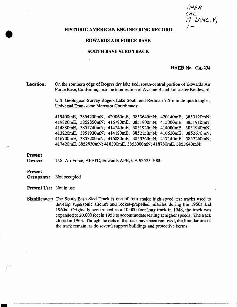
HISTORIC AMERICAN ENGINEERING RECORD
HBBZ
fl-lANC.V, I-
EDWARDS AIR FORCE BASE
SOUTH BASE SLED TRACK
HAERNo. CA-234
Location: On the southern edge of Rogers dry lake bed, south-central portion of Edwards Air Force Base, California, near the intersection of Avenue B and Lancaster Boulevard.
U.S. Geological Survey Rogers Lake South and Redman 7.5-minute quadrangles, Universal Transverse Mercator Coordinates:
419400mE, 3854200mN; 420060mE, 3853640mN; 420140mE, 3853120mN 419800mE, 3852850mN; 415790mE, 3851900mN; 415000mE, 3851910mN 414880mE, 3851740mN; 414740mE, 3851920mN; 414000mE, 3851940mN 413220mE, 3851930mN; 414120mE, 3852150mN; 416620mE, 3852670mN 416700mE, 3853200mN; 416880mE, 3853360mN; 417140mE, 3853260mN 417420mE, 3852830mN; 418300mE, 3853000mN; 418780mE, 3853640mN;
Present Owner: U.S. Air Force, AFFTC, Edwards AFB, CA 93523-5000
Present Occupants: Not occupied
Present Use: Not in use
Significance: The South Base Sled Track is one of four major high-speed test tracks used to develop supersonic aircraft and rocket-propelled missiles during the 1950s and 1960s. Originally constructed as a 10,000-foot-long track in 1948, the track was expanded to 20,000 feet in 1958 to accommodate testing at higher speeds. The track closed in 1963. Though the rails of the track have been removed, the foundations of the track remain, as do several support buildings and protective berms.

Edwards Air Force Base, South Base Sled Track HAERNo.CA-234
Page 2
PARTI. PHYSICAL CONTEXT
The South Base Sled Track (SBST) is located in the south-central portion of Edwards Air Force Base (AFB), near the southern edge of Rogers Dry Lake. The landscape in this area is relatively flat, consisting of high desert terrain and foliage (CA-234-20). The Tehachapi and San Gabriel mountain ranges are visible some 30 miles in the distance. This area is remote and generally undeveloped. A Boy Scout camp is the only active facility in the immediate area. Nearby facilities include the South Gate Guard Shack and Branch Park.
The SBST is composed of buildings, structures, and archaeological elements. It includes the existing sled track; the remains of the 10,000-foot-long sled track; and associated buildings, structures, foundations, access roads, and features.
PART 2. HISTORICAL CONTEXT
Originally known as the Free Air Test Facility, the SBST was constructed in 1948 as a 10,000-foot-long high-speed test track (Bushnell 1959) (CA-234-26). Expanded to 20,000 feet in 1958 (CA-234-27), the track was used to develop supersonic aircraft and rocket-propelled missile systems during the 1950s and 1960s. The SBST was directly related to the United State's efforts to maintain a lead in the development of rocket-powered aircraft and weapons during the Cold War era.
Testing Supersonic Aircraft for U.S. Military
Before World War I, airplanes and air-launched vehicles were seen as eccentric recreational vehicles. Although the U.S. military made little use of aircraft in World War I, it witnessed the introduction of enemy military aircraft. Following the war, the Army expanded its air wing, built airfields for pilot and bombing training, and established the Air Force branch of the Department of Defense in 1947, thoroughly integrating aircraft into the U.S. military arsenal. When the United States entered World War n, it entered a new era in air power in which aircraft could exceed speeds of more than 500 miles per hour. By the early 1940s, planes were being designed and flown to reach faster and faster speeds and were beginning to enter the lower limits of transonic flight, the little understood region between Mach 0.7 and Mach 1.3. (Mach number is the ratio of the speed of an object to the speed of sound in the medium through which it is moving. If a plane is moving at Mach 1, it is moving at the speed of sound.) By the end of World War II and during the Cold War, rocket- propelled aircraft and weapons systems dominated the race for offensive and defensive military superiority. Rocket-propelled vehicles were used for surveillance, transportation, weaponry and, by the 1960s, for reaching and exploring outer space. Many technical advances allowing American aircraft to reach supersonic air speeds were developed and tested between the mid 1940s and the early 1960s.
Edwards Air Force Base, South Base Sled Track HAER No. CA-234
Page 3
An important part of developing rocket-powered aircraft and weapons included testing the components in real-world conditions and recovering the test objects for analysis. Three methods were used to test aircraft and air-borne weapons: wind tunnel, free-flight, and captive-flight research. Wind tunnel testing was the earliest type of research conducted, but the results of such studies were limited by the lack of "real-world" data that could be collected and the problems with testing air flows between Mach 0.7 and Mach 1.2. Shock waves that occurred in wind tunnels simulating these speeds resulted in inaccurate measurements.
Free-flight testing of rocket-powered systems simulated real-world conditions but could provide only limited types of data because the test subject was usually destroyed. Furthermore, it was not always possible to ensure the test subject would land in a secured area.
In captive-flight testing, conceived during World War n, items were placed on a rail-mounted sled and the sled was propelled by rocket propulsion at high speeds (CA-234-22). Early testing focused on determining the pressures of launch, flight characteristics at transonic and supersonic speeds, and deceleration effects on pilots. While the sled traveled, it was monitored by sled- mounted, track-mounted, or camera-stand-mounted cameras and data transmitters.
Captive-flight testing presented at least two advantages over free-flight testing. First, because the test object was captive, it could easily be retrieved and analyzed at the end of the test, preventing both loss and landing in unsecured areas. Second, captive track testing allowed individual components or systems to be tested independent of other elements of the plane. This allowed the researchers to develop multiple components or systems simultaneously, rather than waiting to test a complete vehicle. Test tracks made it possible for "an enormous quantity of critically needed data" to be gathered "at comparatively low cost and with a demonstrated high level of safety" (Ball Jr. 1962:69).
North Base 2.000-Foot-Long Track
The nation's first high-speed test track was built at Edwards AFB (then Muroc Army Air Field [AAF]) in 1944 (Coleal 1960). This track, located at the present North Base, was 2,000 feet long. It was originally built to test a secret World War II weapon known as "Project 16", which was the JB-10, a tail-less flying wing pulse jet engine bomb. The project was abandoned at the end of World War II following use of the test track for several successful launches (Computer Sciences Corporation 1995).
After the war, military and industry officials met to discuss the need for different aircraft safety standards to accompany the development of jet engine technology. The establishment of the Air Crew Deceleration Project in 1946, led by Dr. Stapp, was an outgrowth of this conference (Computer Sciences Corporation 1995). The staff of the Air Crew Deceleration Project developed the parameters to be tested, and the North Base Sled Track was chosen as the site for the testing

Edwards Air Force Base, South Base Sled Track HAERNo. CA-234
Page 4
program. The only real improvement required at the 2,000-foot-long track was the installation of a hydroelectrical braking system to simulate deceleration gravity forces. In the original track configuration, sleds were considered expendable and simply ran off the track at the end of a run (Computer Sciences Corporation 1995).
Human tolerance testing began at the North Base in 1946, with testing limited to acceleration and deceleration studies. Ultimately, the results of this research brought substantial advances in the understanding of pilot stresses in a variety of simulated flight situations and initiated the development of the shoulder strap harness and V-leg strap harness. As longer and more advanced tracks were constructed, the North Base track became obsolete; it was abandoned in 1958 (Eppley 1960). Later, track from the North Base facility was salvaged and sent to Holloman AFB to help with the track expansion project (Computer Sciences Corporation 1995).
Inspired by the successes at the North Base test track, several other large testing facilities were constructed during the 1940s and 1950s. These test tracks were designed to provide a variety of types and locations for testing aircraft and weapon components, including the aspects of terminal ballistics, aerodynamics, aeroballistics, human tolerances, and ejection components. Tracks were used by both military research scientists and private contractors. As an aircraft or weapon system was being developed, the research team would use a track or a combination of tracks best suited to the research needs of the aircraft. Used in this manner, the nationwide system of military test tracks facilitated the development of high-speed aircraft and weapons systems.
By 1957, there were five major rocket propulsion sled tracks in operation. These were Edwards AFB's 10,000-foot-long (soon to be expanded to 20,000-foot-long) high-speed sled track at South Base; the 3,550-foot-long (soon to be expanded to 35,000-foot-long) Air Force Missile Development Center (AFMDC) at Holloman AFB, New Mexico; the 21,500-foot-long Supersonic Naval Ordnance Research Track (SNORT) facility and the 14,000-foot-long Baker 4 track at the Naval Ordnance Test Station, China Lake, California; and the 12,000-foot-long Hurricane Supersonic Research Site (HSRS) (Project Supersonic Missile and Rocket Track [SMART]), Hurricane Mesa, Utah. Smaller tracks also operated at Eglin AFB, Florida; Aberdeen Proving Ground, Aberdeen, Maryland; Naval Proving Ground, Dahlgren, Virginia; and Redstone Arsenal, Huntsville, Alabama (Zachringer 1957). Even with this number of testing locales there was a "great backlog of work stacked up for every track" (Zachringer 1957:96).
In 1949, Holloman AFB in New Mexico was the site of construction for a 3,550-foot-long track facility. This track was constructed as a launching and testing aid for the Snark missile (named for a mythical creature author Lewis Carroll described as part snake and part shark) (Anonymous 1953). By the late 1950s, plans were underway to expand the Holloman track to 5,000 feet. In February 1959, a new and improved 35,000-foot-long track was unveiled and soon became the first place that a mono-rail sled reached velocities greater than Mach 4 (Anonymous 1959).

Edwards Air Force Base, South Base Sled Track HAERNo.CA-234
Page 5
The Hurricane Mesa facility in Utah was constructed in 1955. The track was designed to end at the edge of a precipice so that the track could be used either as a high-speed test track for captive testing or as a free-flight test facility permitting free fall of test articles over the 1,500-foot-high cliff. This facility, sometimes called the Coleman Track, was privately operated by the Coleman Engineering Company for the Air Force's Wright Air Development Center until 1958 when management responsibility was shifted to the Air Force Flight Test Center (AFFTC) (Eppley 1960). By 1958, the facility had been renamed the Hurricane Supersonic Research Center (HSRC) and was being used for air-to-air missile testing. This unique test site was also under consideration as a free- flight launcher for larger staged missiles and space vehicles. One of the first assignments that HSRC undertook was the testing of the escape capsule for the North American X-15 rocket research vehicle (Clark 1958:24). The siting of this facility led to some unique testing opportunities, including the testing and recovery of small air-to-air missiles and counter measure tests against air-to-air missiles. Work at HSRC also progressed in the testing of top-speed capabilities for parachutes, pushing the limit to Mach 1.5 in 1958. The facility, now known as the Hurricane Mesa Test Track (HMTT), is currently the only privately owned supersonic rocket sled track in the United States.
In line with the construction of more specialized facilities, several tracks were built at nearby China Lake in the late 1940s and early 1950s. These tracks began with the construction of the LARK ramp in 1946 and a 1-mile-long moving target track built between 1946 and 1947 (JRP in prep.; Bushnell 1959). The moving target track was modified to become the Baker 4 track in 1947. The Baker 4 track was used for a variety of research, including captive-flight tests, but its usefulness was limited by its light construction (JRP in prep.). Other tracks followed, including the K-2 track, constructed primarily to conduct terminal ballistics testing, and the Six-Degree ramp, which replaced the LARK ramp in 1950. Both the Six-Degree ramp and the LARK ramp were used mostly to launch vehicles, although some captive-flight testing also was conducted.
Each of the China Lake tracks was constructed to fill a testing need; however, their utility was usually limited to specific types of research. Together, these tracks represent a rapid evolution and a steep learning curve in test track construction, culminating in the 1953 construction of SNORT, by far the most sophisticated and successful track built at China Lake. SNORT's greatest improvement over earlier China Lake tracks was its ability to accomplish the full range of testing that sled tracks could provide (JRP in prep.). SNORT is still operational and over the years has made contributions in the testing of aerothermal ballistics, fuzing, guidance control, aircraft components, projectile recovery, escape systems for aircraft and spacecraft, and atmospheric effects (Naval Air Warfare Center Public Affairs Office 1996). A description of major Cold War high- speed test tracks is provided in Table 1.
Each of the major tracks offered slight variations on sled track testing. Edwards AFB and eventually Holloman AFB were known for the length of their tracks. Hurricane Mesa allowed for a combination of captive and free flight. China Lake offered a variety of specialized tracks, as well as one multipurpose track. During the 1950s, track speed records were set at the 10,000-foot-long
Edwards Air Force Base, South Base Sled Track HAERNo.CA-234
Page 6
track at Edwards AFB and the 3,550-foot-long track at Holloman AFB. Meanwhile, North Base Track at Edwards AFB continued to play an instrumental role in aeromedical research into the effects of high-speed acceleration and deceleration through the early 1950s. Because of these differences, many testing programs used more than one track to develop different components of an aircraft or missile.
PART 3. HISTORY OF THE SOUTH BASE SLED TRACK
The following history ofMuroc AAF and sled track development at Edwards AFB is largely adapted from previous studies conducted at the SBST, which are on file with the Base Historic Preservation Officer (Earth Tech 1993, 1996).
Establishment of Edwards AFB
The need to expand and improve U.S. Army Air Corps (USAAC) airfields and equipment was recognized a decade before the beginning of World War n. Consequently, a bombing and gunnery range was laid out in the Muroc area, which was considered particularly well suited for these purposes. The remote area was mostly unsettled and afforded excellent year-round flying weather and a natural emergency landing field (the hard claypan of Muroc [Rogers] Dry Lake). Additionally, 29,000 acres east of the lake bed were already federally owned. In September 1933, a detachment of 20 men was sent from March Field, Riverside, California, to establish a tent camp in support of the new facility.
In 1940, private land, as well as 127,500 acres of federal land in and around the lakebed, was acquired to enlarge the bombing and gunnery range. The following year, a runway and water and sewage systems were constructed, and numerous buildings made up what became known as South Base.
Muroc AAF became increasingly important during World War II, when numerous bombing, reconnaissance, and transport squadrons were stationed there for training. Aircraft testing at Muroc AAF began as early as 1941 and became the primary mission of the facility following the war. The facility was redesignated Muroc AFB in 1948 and rededicated Edwards AFB in 1949. In 1952, base activities shifted to the new main base, and most of the facilities at South Base were abandoned and eventually demolished or relocated. At this time, a new runway was built leading into Rogers Dry Lake.
South Base Experimental High-Speed Track
One of the tracks that made the North Base track obsolete was the 10,000-foot-long AFFTC Experimental High-Speed Track (originally known as the Free Air Test Facility [Bushnell 1959])

Edwards Air Force Base, South Base Sled Track HAER No. CA-234
Page 7
constructed at South Base in 1948-1949. This track was constructed by Northrop Aviation Company under Contract MX-775. The total cost of the project was $448,576.69, and the first run under contractor operation occurred in early 1949 (Anonymous 1960). This track was constructed of standard 115-pound railway rails laid on continuous reinforced concrete beams (C A-234-21) and incorporated a 2,000-foot-long water brake system (Hiroshige et al. 1955; Coleal 1957).
The mission of the Experimental Track Branch at Edwards AFB was to "conduct research, development, and evaluation tests of missile and aircraft systems, munitions, special weapons and related components by means of rocket propelled test vehicles operating on tracks" (Coleal 1960:2). Major areas of testing undertaken at the track facility included ejection and jettisoning systems (CA-234-23), parachute recovery systems, human tolerances, aerodynamic flutter, structural integrity, and acceleration. Some sleds and track components were also designed to test rain erosion on aircraft. By the late 1950s, the need for a longer track at Edwards AFB was apparent. A longer track was necessary to achieve more velocity to meet the needs of new plane systems (Engram 1988). On July 24, 1958, the last sled run was made on the 10,000-foot-long track, after which it was demolished to make way for a 20,000-foot-long track.
Construction of the new track facility began on July 19, 1957. The 10,000-foot-long track was left operational while the infrastructure and support buildings for the new track were constructed. The entire facility was completed on May 13, 1959, at a cost of $3,744,981 (Anonymous 1960). Transition to the new track was smooth, with successful runs made during construction. The first 10,000 feet of new track were completed, and a test run was made on August 15,1958. The full 20,000 feet of track were first used for a test on May 13,1959. Between these two tests, additional runs were made at intermediate lengths (Air Research and Development Command 1960).
The new 20,000-foot-long track extended the speed capabilities of the facility from Mach 2 to Mach 4 (Lawrence 1959), and the track gained a reputation as the "world's fastest and straightest railway" (Stiffler 1952:60). Testing at the 2,000-foot-long deceleration track at North Base was superseded by work at the new track, and the North Base facility was abandoned in September 1958 (Stiffler 1958).
The Track Facilities Guide Book, published in 1960, provided details on the components and capabilities of the test track (Coleal 1960). This guidebook described the system of support equipment required to facilitate the mission of the test track, including "rocket propelled test vehicles capable of transporting models or full-scale test articles at transonic or supersonic speeds; instrumentation for the study and evaluation of test phenomena; braking systems for the recovery of test vehicles; and aural warning and public address systems for proper control and safety during

Edwards Air Force Base, South Base Sled Track HAER No. CA-234
Page 8
hazardous firing operations" (Coleal 1960:2) (CA-234-25). According to that same document, test programs conducted at the SBST included:
missile fuse and warhead systems tests, rain erosion tests, aircrew escape systems, parachute recovery systems, airfoil and empennage (tail assembly) flutter tests, and structural and acceleration tests.
These test programs also aided in the advancing development of:
• water brake recovery systems, • track slippers and bearing design, • shock and vibration isolation systems, and • acoustical environment study and control.
Operations and Testing. As stated by Ball Jr. (1962:71), "the only product of the entire facility [was] data". The meticulous instrumentation and tracking of test runs were accomplished through several complex systems. Sled-borne data transmission and recording systems collected data during test runs. Specific data concerning sled-borne cameras may be found in Cohen (ca. 1950). Instrumented anthropomorphic dummies were equipped with data collection systems to determine stresses particular to the human body. These dummies were designed to reproduce human proportions, weight distribution, articulations, resilience, and other characteristics that determine the forces imposed on a human in a given system, the motions the individual would make, and the terminal condition (Alderson Research Laboratories n.d.).
Coils mounted to the track generated a pulse from the passage of a sled-mounted magnet and could determine velocity with an accuracy of 0.2%. An instrumentation van was equipped for mobile adjustments to vehicles on the track. Range cameras were used, including those capable of capturing 25,600 exposures per second, and some were mounted on stands south of the track. Photographic data were transmitted to the firing blockhouse. Radio communication was maintained between the blockhouse, offices, track vehicles, and portable stations, and a public address system served the entire track complex.
While the track was in operation, continual upkeep and repairs were required, mostly to maintain the precise alignment of the rails (Anonymous 1961). Portions of the track were replaced at intervals as they became worn or damaged during test runs. In 1961, proposals were made to replace the water brake trough.
Edwards Air Force Base, South Base Sled Track HAER No. CA-234
Page 9
Operation of the test track frequently required creative means of procuring supplies. One source stated that a "well-developed ability to scrounge" was among the chief qualifications for personnel assigned to the track (Anonymous 1955). Master Sergeants Dave Smyers and George Faneuf were first to be assigned to duty at the track. Reportedly, they spent the first few months "salvaging spare parts from wrecked aircraft, shoveling sand, jury-rigging equipment, and ducking under buildings" (Earth Tech 1996:2-27). As stated by Ball Jr. (1962:75):
The matter of supply has bothered the track engineers for some time; most of the available budget has to be spent for operating hardware, leaving very little over for support equipment, buildings, and other needed accessories. This situation has developed in the track personnel a remarkable ability to scrounge, and the entire Edwards complex offers a fertile opportunity.
Several buildings were scavenged from other areas of Edwards AFB to be used at the SBST. At least one building (Bldg. 518) from the North Base deceleration track was moved to the South Base track, where it was more urgently needed (King 1956). Four buildings constructed as World War II barracks were moved to the 20,000-foot-long track. All that remains of these structures are foundations or footings. Two observation towers were also imported to the sled track (Bldgs. 505 and 515). Perhaps the most impressive relocation attempt was the successful move of the 200,000- gallon water tower, upright, across 4 miles of desert to the track site.
During a typical test run, the technical personnel were positioned at observation points behind safety barricades. A loudspeaker and siren directed personnel and provided a warning system. Other personnel were busy making last-minute checks of rockets and instrumentation. A firing alert was sounded 45 minutes before firing, and the loudspeaker and siren were used to indicate progress toward firing. Personnel worked toward the final count down, until with a roar, the rockets ignited and the sled leapt forward. If the test was a supersonic run, a sonic boom was heard that, because of proximity, was much louder that those heard when planes break the sound barrier. (Anonymous n.d.) After the run, instrumentation calibrations were processed and the data compiled. Within a day or two, the performance characteristics of the aircraft or missile were known.
By 1961, reductions began in track operations, including cut backs in the number of personnel assigned to track duty. By 1962, the track at Hurricane Mesa had closed, and track testing became focused at the AFMDC track at Holloman AFB. The decision to transfer aircraft component testing to Holloman AFB and deactivate the SBST was a financial one. Personnel at Holloman AFB wrote a proposal stating that they could absorb all the testing that was taking place at Edwards AFB and save the Air Force millions of dollars per year because they could conduct two tests simultaneously. (Engram 1988.) Having little time to prepare a counter proposal, Edwards AFB could not prove its worth to AFMDC, which reviewed both proposals and voted in favor of the Holloman AFB track. The AFFTC 20,000-foot-long track was deactivated in 1963 (Anonymous

Edwards Air Force Base, South Base Sled Track HAERNo. CA-234
Page 10
1962). Since then, rails and other components have been salvaged for use in augmenting the Holloman AFB track and for improvements at other test facilities (Earth Tech 1996).
PART 4. DESCRIPTION OF SOUTH BASE SLED TRACK
According to Original Plan
The original South Base High Speed Test Track at Edwards AFB was located near the southern edge of Rogers Dry Lake and ran roughly southwest-northeast for 10,000 feet (C A-234-26). The track was accessible via Scout Camp Road, which curves south at the end of the track. An access road paralleled the track to the south. The track could also be reached via several roads leading north from Avenue B. The track was constructed of standard 115-pound railway rails laid on continuous reinforced concrete beams, which were tied together with reinforced concrete ties every 9 feet (CA-234-21). A line of cameras was located 360 feet south of the track, along the camera road.
The beginning of the 10,000-foot-long test track (the western end), where sleds were "launched", consistedof a core of five buildings and one outlying building (CA-234-20). Buildings in the core area included a firing control building (Bldg. 502), a shop (Bldg. 501), and other storage and operations facilities. The outlying building (Bldg. 503), located at the end of a road to the west of the launch area, was a bunker for the storage of explosives; this building predates the sled track.
Another concentration of buildings was located at the halfway point of the sled track. The water tower (Bldg. 516) and well pumphouse (516A) were located north of the sled track. Immediately south of the sled track were four buildings. One of these buildings, the observation and control building (Bldg. 512), was located on the west side of a north-south access road. The remaining three buildings (Bldgs. 513,514, and 515) were located on the east side of the access road. Two buildings that appear to have been shops (Bldgs. 517 and 518) were located south of the camera road parallel to the sled track.
A water trough, which was part of the water brake system, was located between the rails and extended for the last 2,000 feet of the track. A rainfall range consisting of mounted sprinkler heads spanned 2,100 feet of track. Two buildings (Bldgs. 520 and 521) were located near the end of the sled track.
Bldg. 510, a former firehouse, was located on Scout Camp Road approximately 1 mile north of the sled track. It was used as an administrative building while the track was in use.

Edwards Air Force Base, South Base Sled Track HAER No. CA-234
Page 11
As It Changed Over Time
The 10,000-foot-long sled track was retired in 1957, and construction began on a new 20,000-foot-long track (CA-234-27). The alignment of the track remained the same, but the track was extended 10,000 feet to the west. The firing direction changed, and the terminus (east end) of the 10,000-foot-long track was made the beginning of the 20,000-foot-long track. The track was dismantled and completely replaced, but many of the buildings were reused. Several buildings were moved from other areas of the base. Bldg. 518 was moved to the South Base Sled Track from the North Base Deceleration Track. Two observation towers (Bldgs. 505 and 515) and the water tower (Bldg. 516) were imported from Main Base.
Associated with the 20,000-foot-long sled track were several operations areas, facilities, and structures (CA-234-29). Station "00" at the beginning (eastern) end of the track was used as a staging area (CA-234-28). Station "50" is located 5,000 feet from the beginning of the track and consists of a concentration of buildings along the north-south access road from Avenue B (CA-234-30). Bldg. 510, roughly 1 mile northwest on Scout Camp Road, served as the administration building for the facility. Elements of the track include the track itself, a rainfall range just west of Station "50", and a water brake area at the western end of the track.
Station "00" consisted of buildings, protective berms, fueling and electrical facilities, and several roads connecting these buildings and structures (CA-234-1). Buildings situated north of the track were support buildings and included a substation (Bldg. 522) (CA-234-11), a water tank and pump house to supply water for fire protection (Bldgs. 541 and 540), and a liquid propellant storage area with piping to the track (CA-234-2, CA-234-12). Southeast of the launching pad was the firing control block house (Bldg. 545) and associated air supply building (CA-234-14, CA-234-15). These buildings were protected by berms and connected by tunnels (CA-234-13). The motor pool and a cluster of operations buildings were located still further south. Included in this cluster of buildings were the instrumentation building (Bldg. 533), the project building (Bldg. 532), the operations office (Bldg. 531),and the maintenance building (Bldg. 530).
Station "50" was located 5,000 feet from the beginning of the 20,000-foot-long track, at what was the midpoint of the 10,000-foot-long track (CA-234-8). Bldg. 512, the observation and control building for the 10,000-foot-long track, was modified and reused as a receiving station for the 20,000-foot-long track. South of the access road, Bldgs. 517, 518, and 519 were reused as an electronic lab, a photo and supply building, and a fabrication shop, respectively. Also located within Station "50" was a static test net situated south of the sled track and east of the fabrication shop.
The track was completely replaced. The 20,000-foot-long track was constructed of heavy- duty crane rails weighing 171 pounds per yard. These rails were set at a standard railroad gauge of 56.5 inches on monolithic reinforced concrete beams (Ball Jr. 1962)(CA-234-24). The welded rail sections were anchored at both ends to reduce the effects of expansion and contraction (CA-234-6).

Edwards Air Force Base, South Base Sled Track HAER No. CA-234
Page 12
The anchors consist of massive concrete anchor blocks containing steel piles penetrating 40 feet into the ground (Ball Jr. 1962) (CA-234-7). Horizontal and vertical alignment of the track was facilitated by the placement of permanent control monuments on the south edge of the track and parallel to the track at a distance of 162 feet south.
The test track was equipped with a water brake system effective in slowing and stopping heavy sleds traveling several times the speed of sound (Ball Jr. 1962) (CA-234-25). The water brake was located in the last 6,000 feet of track (Coleal 1960). A simulated rainfall range was added to the test track. The rainfall curtain was 2,400 feet long, beginning at Station "50", and could deliver a spray of water equivalent to 8 inches of precipitation per hour (Lawrence 1959). A later modification lengthened the rainfall range to 10,000 feet, with a capacity of 17 inches of rain per hour. An underground pipe system carried water from the 200,000-gallon tank to sprinkler heads.
Some research and support structures were located parallel to the track along its entire length. Four berms with barricades (and superstructures, in some cases) used for viewing were located at fairly regular intervals along the south side of the track. Camera stands were spaced in four rows at regular intervals. The tallest stands were organized in two rows farthest from the track and were concentrated between Station "50" and the midpoint of the track (CA-234-17, C A-234-18). One row of permanent camera stands along the camera road ran parallel to the SB ST for the entire length (CA-234-15). Trackside cameras located 14 feet south of the track also spanned the entire length. Earth-covered, semi-subterranean storage bunkers were located at irregular intervals along the sled track. Some storage bunkers associated with the 10,000-foot-long track were reused. Storage bunkers were used to store solid- and liquid-propellants and miscellaneous parts.
Current Features and Appearance
Located in the south-central portion of Edwards AFB, on the southern edge of Rogers Dry Lake, the SBST is composed of buildings, structures, and archaeological elements. It includes the existing sled track; the remains of the 10,000-foot-long sled track; and associated buildings, structures, foundations, access roads, and features.
The existing sled track is the organizing element of the entire facility. The track runs northeast-southwest (roughly 80 degrees to 260 degrees) for 20,000 feet, beginning just west of where Scout Camp Road turns south. The track crosses Lancaster Boulevard, north of Avenue B. The facility measures roughly 4 miles east to west and 1 mile north to south. Although the sled track is entirely within Los Angeles County, some associated buildings and features are located just north of the county line, in Kern County.
The existing sled track can be divided into several functional areas or categories. Station "00", the eastern starting point, was the firing control and fuel delivery area. Station "50", a quarter of the distance down the track, was an instrumentation and maintenance center. A series of viewing

Edwards Air Force Base, South Base Sled Track HAER No. CA-234
Page 13
stands, protective berms, and other miscellaneous structures is located to the south of the track. Several types of camera stands used in photodocumentation of the experiments at the sled track facility were located along the rows 360 and 720 feet from the track. The rainfall range made it possible to test the effects of rain at transonic and supersonic speeds. The water brake area was integral to retrieving test sleds. Table 2 provides a summary of the individual properties, their condition, and their functional association.
Sled Track. The sled track runs northeast-southwest and is about 3 feet wide (CA-234-3). The iron rail of the track is missing, but the base and the bolt plates remain, as do associated features. The monolithic, reinforced concrete base consists of a crenelated H-shaped form 3 feet high and 6 feet, 5 5/8 inches wide; about half of the height is subterranean. The original track gauge was 4 feet, 8 inches. The steel bolt plates vary along the length of the track. Four sets of anchor fixtures are located at the eastern end of the track, and similar fixtures are located near the half way point and again at Station "200" (CA-234-9). These anchor fixtures stabilized the ends of the rails and prevented them from pulling out during the test runs. The other type of bolt plate is located in the well of the crenel and consists of two vertical bolts and a horizontal bar (CA-234-4). These were related to the sleepers that supported the rails. The sleepers were metal plates that could be finely adjusted vertically and horizontally, allowing the test engineers to ensure a straight, level test track.
Electrical distribution stations are located approximately 25 feet south of the sled track at regular intervals along the 4-mile length of the sled track (CA-234-I-1, CA-234-5). These three- walled concrete block structures have poured concrete foundations and are characterized by a circular perforation in the track side wall and associated electrical boxes (CA-234-I-2). They are in various states of repair. Other features directly associated with the track include cement pads at the eastern and western ends of the track and at several points in between (CA-234-10); target boards; benchmarks; concentrations of debris from construction, such as bolts and sleeper plates; demolition debris, such as blocks of reinforced concrete track base from the original 10,000-foot-long track; and sled crash debris, such as twisted metal, rocket casings, and other distressed vehicle parts.
Station "00". Much of Station "00" is still intact. The presence of buildings and their associated protective berms, as well as the sled track and launching pad, make this area one of the most evocative areas at the facility. This area encompasses approximately 100 acres and includes the structures and protective berms north of the track, the launch area, the firing control blockhouse, air supply building and associated berms, and the remains of Bldgs. 530 through 533 (CA-234-1).
A cement pad and loading platform are the easternmost features of the track. The loading platform consists of a small concrete ramp with deep gutters on either side, which leads up to a concrete pad with a metal bumper or bar. A sled carrier of rails located nearby presumably was used to load sleds. Access roads, trackside roads, and the camera road are all intact.

Edwards Air Force Base, South Base Sled Track HAER No. CA-234
Page 14
Several buildings and their associated protective berms remain. The firing control blockhouse (Bldg. 545) and associated air supply building are still standing and complete, although they are not maintained and have been vandalized. Bldg. 545 is a rectangular, one-story, wood-frame building with a board-formed concrete foundation and flat, built-up gravel roof with metal coping (CA-234-A-1, CA-234-A-2, CA-234-A-3, CA-234-A-4, CA-234-A-5, CA-234-A-6). This structure's interior was configured for computer equipment that is no longer present (CA-234-A-7, CA-234-A-8, CA-234-A-9). A tunnel from the firing control blockhouse leads to a stairway that surfaces near the southern edge of the sled track, but the staircase is blocked with debris (CA-234-A-10, CA-234-A-11, CA-234-A-12, CA-237-A-13). The air supply building is a rectangular structure constructed of hollow two-chamber concrete blocks. The built-up roof is lying on the ground nearby (CA-234-B-1, CA-234-B-2, CA-234-B-3).
Also south of the sled track is a viewing station (Bldg. 520) (CA-234-C-1). This rectangular structure is of concrete block with a board-formed concrete foundation (CA-234-C-2, CA-234-C-3). The roof is wood framed, built up with galvanized steel coping. The viewing station is characterized by steel-framed bullet-glass viewing windows and a bowed facade, which are intact (CA-234-C-4, CA-234-C-5). An electrical station is attached to the southwest facade.
Protective berms on the north side of the sled track shield a substation, the fire prevention water reservoir and pump station (Bldg. 540), and the liquid propellant storage facility. The substation is in ruins, but the association with the track and berm is still extant. The pump station remains standing (CA-234-D-2). It is a rectangular concrete block structure with a built-up roof (CA-234-D-1). The pump, pump mount, and power panel that are part of this building remain inside. However, all that remains of the water reservoir is a circular concrete foundation. The liquid propellant storage facility is now represented by several foundations for tanks and the remains of the delivery system. A line of supporting metal rods for the pipes, valves, holding ponds, and valve pits is associated with this system.
Protective berms in Station "00" and at other locations along the South Base Sled Track were constructed with an infrastructure of reinforced concrete and I-beams covered with earth and macadam. Though some erosion has occurred, leaving the berms with uneven surfaces with virtually no macadam, much of these berms remains.
South of the camera road were several support buildings, including the instrumentation building (Bldg. 533), project building (Bldg. 532), operation office (Bldg. 531), and maintenance building (Bldg. 530). All that remains of these structures is a series of footings.
Station "50". Station "50" is a group of buildings located 5,000 feet west of the eastern end of the sled track (CA-234-F-1). The boundaries of this area extend south about 1,000 feet from the sled track. Only one building of the original six remains standing, the (telemetering) receiving station (Bldg. 512) (CA-234-F-2). All that remain of the other buildings are footings. The receiving
Edwards Air Force Base, South Base Sled Track HAERNo. CA-234
Page 15
station is constructed of concrete blocks topped with reinforced concrete (CA-234-F-4). The roof is flat and holds HVAC equipment. Bldg. 512 is characterized by the existing bullet-glass viewing windows (CA-234-F-3). This building is the product of two phases of construction. The northern portion of the building was constructed in 1951 as an observation and control building (CA-234-F-6). A large southern addition was constructed in 1959 (CA-234-F-5). Bldg. 512 was later modified for use as a communications facility. South of Bldg. 512, across a small drainage spanned by a bridge that also houses conduit, are the foundations of three buildings. Access roads in this area are overgrown, but still functional.
Camera Stands and Viewing Towers. There are several types of camera stands along the length of the track: trackside camera stands, metric camera stands along the camera road, and manned camera towers. Trackside camera stands consist of a metal box (to protect the camera) mounted on a metal post. These are located at several points immediately along the track; in some cases, the metal box is missing.
A row of camera stands is located along the camera road, which runs parallel to the sled track, approximately 400 feet to the south (CA-234-15). The various types of camera stands along this road are about 50 feet apart. Some camera stands consist of a rectangular concrete post topped by a rectangular camera mount. A platform supported by knee braces and surrounded by an angle iron railing is located about 3 feet below the camera mount. In some cases, the platform is not continuous and is supported by vertical angle iron posts. Electrical boxes are mounted on multiple sides of the concrete post near the ground. Some of the camera stands on the west side of Lancaster Boulevard consist of a vertical, hollow steel post, approximately 7 feet tall, mounted in a concrete slab (CA-234-16). Three nobs are located on the east side. An electrical box is located on the north side of each post, near the bottom.
A row of camera towers is located along a road about 1,600 feet south of the sled track, between Station "50" and the midway point (Station "100") (CA-234-17). These stands consist of 12-foot-tall tripods constructed of angle iron, topped by a square platform with iron railings (CA-234-18). Access to the platform is provided by an attached ladder. A circular camera mount is attached, off center, to the platform.
Taller camera or viewing towers are located more sporadically. One is located next to Bldg. 502 and another west of Lancaster Boulevard, approximately 1,600 feet south of the sled track. These structures consist of a 30-foot-high tripod tower of angle iron. An access ladder is fitted with a circular cage. The hexagonal platform is of mesh surrounded by a circular safety railing, giving the structure the appearance of a crow's nest.
A tall, enclosed observation tower is located approximately 1,800 feet south of the sled track, near the western end (CA-234-J-1). This tower is constructed of galvanized angle iron, which is numbered and labeled for Edwards AFB. The access stairway has four flights of wooden steps in
Edwards Air Force Base, South Base Sled Track HAERNo.CA-234
Page 16
good condition. A viewing platform enclosed with corrugated sheet metal is reached from a wooden trap door.
Viewing Stands. There are four viewing stands consisting of berms and railroad tie "fences" or barricades roughly equally spaced along the sled track. All are composed of a berm with a partially subterranean railroad tie barricade. In some cases, there is a wooden platform to stand on, supports for some kind of roofing, or bleacher-type seating.
The VIP viewing stand located just west of Area "50" is the most elaborate (CA-234-H-1). A central dilapidated wooden staircase provides access to the viewing stand atop the berm. Two rows of upright railroad tie posts have diagonal railroad tie braces. The rows of posts are connected by railroad tie beams, which are box jointed and bolted. The structure is fronted with fencing (2- by 6-inch boards), braced by cross members (4- by 4-inch boards) at the top and bottom, which are connected to the railroad tie posts with bolt plates. The barricade is partially buried in the berm on the track side.
Another viewing stand is located about 1 mile from the western end of the sled track. Situated about 400 feet south of the track, this viewing stand consists of a berm, a railroad tie barricade, and two sets of wooden bleacher-type seats. The remaining two viewing stands consist of railroad tie barricades. One is located on a dune just south of Bldg. 502, and the other is located about 1,000 feet from the western end of the sled track.
Rainfall Range and Water Brake Area. Nothing remains of the rainfall range. The only remaining evidence of the water brake area is an isolated segment of trough located near Bldg. 502.
Administration Bldg. (510). The administration building is located approximately 1 mile north of the sled track, along Scout Camp Road and is the most removed element of the sled track. According to as-built drawings and plot plans, this building originally served as a fire station. The building was used as an administration building for the SBST.
This building is constructed of stud framing with asbestos cement sheeting and has a corrugated metal roof and concrete foundation. Bldg. 510 consists of three components: the garage with bay doors, a one-story portion that wraps around the garage, and the tower. The garage has a gabled roof, and the one-story portion that wraps around the building has a low pitched gable roof with deep projecting eaves. The tower has a flat roof with deep projecting eaves and a wooden sliding window on each facade immediately below the roof. All doors and windows are wood framed.
The eastern facade is visually dominated by the three bay doors on the garage portion of the building, although the tower and one-story wrap-around portion are visible. Two of the bay doors
( seem original, although one is covered with plywood sheeting. The north facade consists of the

Edwards Air Force Base, South Base Sled Track HAERNo.CA-234
Page 17
garage and the one-story wrap-around portion, which projects north and west from the garage. The garage is visible above the one-story wrap-around portion of the building on the western facade, and all three components of the building are visible on the southern facade. Most of the doors and windows seem original, although several are filled in.
Static Test Site. The static test site was located south of the camera road and east of Station "50". Previous studies indicate that nothing remains of the static test site (Earth Tech 1996).
Miscellaneous Structures.
Bldg. 513 - Well Pumphouse. Bldg. 513 is a well pumphouse located north of the sled track near the water tower. This rectangular building is constructed of concrete blocks and contains a pump, pump mount, and power distribution and well-monitoring panel. The foundation is concrete with a poured concrete slab floor. The poured concrete shallow shed roof is pierced in two places; there is a small square opening above the westernmost valve and a larger rectangular opening above the well pump. The eastern facade is open, and it appears that a door (or doors) has been removed. A flammable materials storage locker is mounted to the exterior north wall. The pump house is currently inoperable.
Bldg. 502 - Original Firing Control Blockhouse at Station "100". Bldg. 502 is a semisubterranean structure of reinforced concrete (CA-234-G-1, CA-234-G-3, CA-234-G-5). A heavy steel vault-style door opens onto a concrete block enclosed stairway with a reinforced concrete roof, which may be a later addition. This stairway leads to the original sliding steel entrance door (CA-234-G-2, CA-234-G-6). Characteristic features that remain include a single bullet glass window and interior electrical control panels (CA-234-G-7, CA-234-G-8). The original upper viewing is by means of a clerestory (an upper portion of a wall containing windows) at a 60-degree angle (with the aid of mirrors), but it has been in filled with cement blocks (CA-234-G-4, CA-234- G-9).
A 30-foot-high tripod viewing tower of angle iron is situated just south of the blockhouse (CA-234-G-1). The access ladder is fitted with a circular cage, and the viewing platform is a hexagonal expanded metal stage with a surrounding circular safety rail.
Bldg. 521 - Explosives Storage Bunker. Bldg. 521 is approximately 2,000 feet north of the sled track and is accessible via a narrow paved road. Its isolated location reflects its original function as a storage bunker for explosives. This earth-covered bunker is constructed of board-formed concrete. The only visible facade has a steel-framed door (CA-234-E-1). The earthen berm was covered with macadam, which is now significantly eroded (CA-234-E-2).

Edwards Air Force Base, South Base Sled Track HAERNo.CA-234
Page 18
Bldg. 516 - 200,000-Gallon Water Tower. The water tower is approximately 600 feet north of the sled track near Station "50". It was originally constructed before 1954 and moved to this location from the original site of Edwards AFB in 1955. (Anonymous ca. 1962.)
Bldg. 503 - Solid Rocket Storage Bunker. Located near Station "100", Bldg. 503 is approximately 900 feet from the sled track, along a dirt road. Real estate records indicate that this structure formerly was a P-29 igloo, built in 1953 (Earth Tech 1996). This building was used for solid propellant rocket storage (CA-234-E-5), but use in this capacity was discontinued because of its proximity to the 20,000-foot-long sled track.
This wood frame bunker was built on a concrete slab foundation, covered with earth, and sealed with macadam, which has eroded considerably (CA-234-E-4). The shiplap pine facade has double wooden doors with diagonal tongue and groove siding. A board-formed concrete loading platform projecting from this front facade is covered by a gable roof supported by metal pipes and wood posts with knee braces (CA-234-E-3).
A toppled guard shack, which appears to be associated with this bunker, lies nearby. It is of wood frame construction with shiplap siding and a tar-papered gable roof.
Unnumbered Storage Bunker. About 750 feet south of the sled track, between Station "50" and Station "100", is an unnumbered storage bunker with uncertain association. The wood-framed Quonset-hut-style storage bunker has arched wood supports (similar to Bldg. 503). It is located in a constructed trench and covered with earth; there is no evidence of macadam. The entrance is dominated by wood-post-framed double doors with horizontal tongue-in-groove siding. The interior, approach, and front facade are in good condition. The doors are in a poor state of repair, and one is in pieces.

Edwards Air Force Base, South Base Sled Track HAERNo.CA-234
Page 19
e
£
3-
a
;*1 U
2 H
1 a, <? ■a a «
■a "3 u o
'SP £
■8
■M IMP **
X 3 5
b.2 a
a * =* ft ■ © <3 '- y
sr
"3 OS
3
ON
s 2 £ 2
.1 ON
o o o
•3 *
K = * C\ J3 —
o> I
OS — —■ (S
S
"8
CO
Q
"g J 4> a a
9> 13 »*to := * W cT K 3 - - "C .<£ t> w S § ■*» -e £
? T3 3 .2P
5 s s H
%
*
"I | rf « -in | S J 8
lit1"
S o\
*2 «
8 •8 a
il &
s o •c
3 S
r-
5
1) bo
c
'I 5
tn o
SS-§
Edwards Air Force Base, South Base Sled Track HAER No. CA-234
Page 20
Table 2. Sled Track Elements - Classification.
':"!T-'i::'1 jilll^ nii^?-'
Sled track Fair
/;lil- v: \;'--V :.\:;/v;;;l§[;
Steffi ST-1 Testing - sled track
ST-2 Bldg. 545, Firing control Fair Research and F-10 building development buildings
and testing - instrumentation
ST-3 F-ll Air supply building Fair Testing - associated support
ST-4 Bldg. 540, Fire prevention F-15 water reservoir and
pumphouse
ST-5 F-16 Liquid propellant storage facility
ST-6 - Sled transport/cart
ST-7 — Concrete valve chamber, Station "00"
ST-8, 50, F-19 Camera stands and 51,53, (ST-68) towers 68
ST-9 Bldg. 520, Viewing station F-9
ST-10 Bldg. 533 Instrumentation building
ST-11 Bldg. 532 Project building
Fair (standing pump Testing - associated house, foundation of support buildings reservoir)
Poor (footings)
Fair
Fair
Good to fair
Fair
Poor (footings only)
Poor (foundation only)
Testing - storage
Testing - sled and track
Testing - infrastructure
Research and development - photographic facilities
Research and development - observation facilities
Research and development buildings
Research and development buildings

Edwards Air Force Base, South Base Sled Track HAERNo.CA-234
Page 21
Table 2. Sled Track Elements - Classification Continued.
ST-12 Bldg. 531 Operations office Poor (footings only) Research and development administration
ST-13 Bldg. 530 Maintenance building
Poor (footings only) Research and development buildings
ST-14 Bldg. 529 ~ Poor (foundation only)
Research and development buildings
ST-15 Bldg. 528 — Poor (foundation only)
Research and development buildings
ST-16 Bldg. 512, F-8
Telemetering receiving station
Fair Research and development buildings
ST-17 Bldg. 517 Instrumentation lab Poor (foundation only)
Research and development buildings
ST-18, 39
"
Wells Good to fair (various states of repair)
Testing - infrastructure
ST-19 Bldg. 513 Well pumphouse Fair (missing dooifs], east facade exposed)
Testing - infrastructure
ST-20A Bldg. 514 Electrical substation
Good (in use) Testing - infrastructure
ST-20B Bldg. 521, F-17
Explosive bunker Good Testing - storage
ST-21A Bldg. 516 Water tower Good Testing - infrastructure

Edwards Air Force Base, South Base Sled Track HAERNo.CA-234
Page 22
Table 2. Sled Track Elements - Classification Continued.
ST-21B Bldg. F-3
502, Firing control blockhouse
Good Research and development buildings and testing - instrumentation
ST-22 Bldg. 501 Test vehicle mod. and assembly shop
Poor (foundation only)
Testing - associated support buildings
ST-23, 40
Bldg. 509, F-5 (ST- 23)
Electrical substations
Fair to poor (various states of repair)
Testing - instrumentation
ST-24, 65
~ Debris, possible targets
Fair (concrete rubble)
Testing - crashes and debris
ST-25 — Pond Fair (fenced storage area)
Testing - infrastructure
ST-26, 35, 39, 45
F-2 (ST- 26)
Electrical distribution station
Fair (various states of repair, most standing)
Testing - instrumentation
ST-27 ~ Crash site near Station "50"
Fair (debris) Testing - crashes and debris
ST-28, 29,34
— Protective berms Fair (slightly eroded)
Testing - infrastructure
ST-29 ~ Master substation and protective berm
Fair (fenced substation)
Testing - instrumentation
ST-30 Bldg. F-18
503, Solid rocket storage bunker
Fair Testing - storage
ST-31 ~ Possible crash site Fair (debris) Testing - crashes and debris

Edwards Air Force Base, South Base Sled Track HAER No. CA-234
Page 23
Table 2. Sled Track Elements - Classification Continued.
uSSt. "* r '.:,r-
jprtcnption -V;
ST-32
ST-33
ST-36
ST-37
ST-38
ST-41
ST-42
ST-43
ST^4, 48, 52, 64,77
ST-46, 57
ST-47
ST-49, 61
F-14
F-14
F-13
Bldg. 518
Possible settling pond
Water valve in Station "00"
Track precision alignment monuments (concrete and metal benchmarks)
Fenced oxidation pond - Station "00"
Entrance gate
Concrete pits (various locations)
Storage tank
Machine shop
Tower footings
Prehistoric resources
Fair (earthen pit) Testing - infrastructure
Fair
Good
Testing - infrastructure
Testing - infrastructure
Fair
Fair (two steel fenceposts)
Fair (empty)
Testing - infrastructure
Testing - infrastructure
Testing - infrastructure
Poor (supports only) Testing - storage
Poor (foundation only)
Poor (footings only)
Research and development buildings
Research and development - observation
Not associated
L-shaped fenceline Poor (fenceposts) Testing - infrastructure
Possible structural remains
Fair (milled wood, cable [49], cans [61])
Testing - crashes and debris

Edwards Air Force Base, South Base Sled Track HAER No. CA-234
Page 24
Table 2. Sled Track Elements - Classification Continued.
;"''.:•- "■,":i;i"5;n";:"
F-6
■ t -„,-. ,.,-.*,,„.™;,«j„ \, '■ -W • rt ^^w, ■■,.,^.,.,-,>..^
^^^^3ffi^**aS 8w^8W>8 ;;•;•••"•;*-v-f ^ f J:-' 3ft: J*T # B ■. -■h^BKJVJilfyjg^f
;:|-^tl-4iLUVS • •. JV . A'$ rcSfSptSffiVGnS! TBJF *Jfralit.1 "V-IK™* ^■■oHasFairiw ST-54 Storage bunker in
trench Fan- Testing - storage
ST-55 Tripod Fair (possible camera or transit?)
Research and development - photographic facilities
ST-56 — Expended rocket motor
Fair Testing - crashes and debris
ST-58 ~ Trash dump Fair (military and homestead artifacts)
Testing - crashes and i debris
ST-59 Guardshack Poor (toppled, associated with bunker 503)
Testing - infrastructure
ST-60 — 10,000-foot-long track rubble
Fair Testing - track and sled, crashes and debris
ST-62 Sled track alignment jacking equipment
Poor (not located) Testing - track and sled
ST-63, 69, 72, 80
F-1 (ST- 69), F-4 (ST-80), F-7 (ST- 72)
Viewing stand with protective berm
Fair Research and development - observation
ST-66 Avenue B bridge and culvert (concrete)
Fair Testing - infrastructure
ST-67 — Unidentified building
Poor (foundation) Research and development buildings
Edwards Air Force Base, South Base Sled Track HAER No. CA-234
Page 25
Table 2. Sled Track Elements - Classification Continued.
ST-70
ST-71
ST-74
ST-75
ST-76
ST-78
ST-79
JSA-1
JSA-2
JSA-3
JSA-4
JSA-5
Bldg. 521 (formerly)
Bldg. 510
F-12
Obstacle course near Station "00*
Old well house
Fire station/administrati on building
Track rail section
Construction/decon struction area (e.g., wooden debris, metal plates)
Burned bone scatter
Section of water brake trough, near Bldg. 502
Valve pit
Fuel line remnant
Staircase to tunnel leading to Bldg. 545
Light pole
Debris scatter in drainage near Bldg. 545 (lockers, concrete rubble)
Poor (foundation and well cap)
Fair
Poor (not located)
Fair
Fair
Fair
Fair
Fair
Poor (cut down)
Fair
Not associated
Testing - infrastructure
Research and development - administration
Testing - track and sled
Testing - crashes and debris
Not associated
Testing - brake system
Testing - infrastructure
Testing - infrastructure
Testing - instrumentation and - infrastructure
Testing - infrastructure
Testing - crashes and debris

Edwards Air Force Base, South Base Sled Track HAER No. CA-234
Page 26
Table 2. Sled Track Elements - Classification Continued.
JSA-6
JSA-7
Target boards, Fair (various states numerous locations of repair)
Conduit bridge Fair between Bldgs. 512 and 517
Research and development photographic facilities
Testing - infrastructure
— = not applicable. ST numbers assigned by EarthTech 1995 (EarthTech 1996). JSA numbers assigned by Jones & Stokes Associates 1998.
Edwards Air Force Base, South Base Sled Track HAERNo.CA-234
Page 27
PART 5. SOURCES OF INFORMATION
Interviews
Two oral history interviews were conducted with three individuals who worked at the South Base Sled Track facility prior to its deactivation in 1963: Chuck Engram, and Virginia and Ernest Coleal. Following are summaries of these interviews. The oral histories were conducted according to the guidelines established in the Technical Report Legacy of Pancho Barnes Oral History Program (Terrero 1994). The interviews were recorded on audio tapes and transcribed. Tapes and transcripts of these oral history interviews are archived at the Edwards AFB Curation Center.
Charles Engram:
On March 18, 1998, an oral history was conducted with Charles "Chuck" Engram, former Chief of the Liquid Rocket Unit at the SBST from 1952 through 1962. Mr. Engram provided approximately one hour and 50 minutes worth of recollections about his career path, the operations of liquid rocket sleds at the 10,000- and 20,000-foot-long tracks, construction of the 20,000-foot- long track, unique test programs, and the decision to close the SBST in 1962. Mr. Engram's interview assisted the researchers by clarifying many aspects of how the track evolved and how that affected the testing programs, as well as how the built environment was used to achieve the mission of the Track Branch. In addition, Mr. Engram's experiences at the Rocket Lab at Edwards AFB both before and after his years at the SBST provided a unique perspective on the role of the Track Branch within both the rocket research being conducted at Edwards AFB and the role of rocket propulsion within the Cold War period. Finally, Mr. Engram shared copies of reports, documents, and photographs from his own collection that had not been found at other research venues and that may well be unique research resources. It is highly recommended that Mr. Engram be contacted for future oral history programs concerning the Rocket Lab site, the F-15 program or to discuss curation of his personal collection of historical documents. His knowledge and collected materials have made a valuable contribution to the research, evaluation, and documentation of the SBST.
Virginia and Ernest Coleal:
On March 17,1998, an oral history was conducted with Ernest Coleal, engineer at the SBST from 1950 through 1962, and his wife, Virginia, a secretary and the only woman working at the SBST from 1954 to 1958. The Coleals provided approximately 60 minutes worth of recollections about their work in sled track research and at the SBST. Mr. Coleal was among the first engineers to work at the SBST and was able to provide the interviewer with information about construction of facilities, early operation of the 10,000-foot-long track, and construction and operation of the 20,000-foot-long track. Mr. Coleal provided information on the operation of solid propellant rocket sleds; the development of slippers, water brake systems, and photographic techniques; the built environment at the SBST; and the role of the SBST in relation to other track facilities, main base

Edwards Air Force Base, South Base Sled Track HAER No. CA-234
Page 28
personnel, and contractors. Additionally, Mr. Coleal shared some impressions of work carried out at the 2,000-foot-Iong North Base Deceleration Track. Mrs. Coleal shared her unique impression of the social aspects of working at the SBST. The recollections of the Coleals assisted the researchers by clarifying how individual systems worked, how testing was accomplished, and how the built environment evolved over the years.
Bibliography
Air Research and Development Command (ARDC) 1960 Rocket Sled Design Handbook. Air Force Missile Development Center, Air Force
Flight Test Center, U.S. Naval Ordnance Test Center. January 1960.
Alderson Research Laboratories n.d. Anthropomorphic Test Dummy Mark III. New York, New York.
Anonymous 1953 Track History, History of the Engineering Laboratory Directorate Flight Test and
Development, AFFTC, November 1953. On file at Office of the Base Historian, Edwards Air Force Base, California.
1955 Edwards High Speed Rocket Sled Track Grew from Odds andEnds. Antelope Valley Press. 13 January.
ca. 1958 Retirement of the Air Research and Development Command, Air Force Flight Test Center - 2,000* Deceleration Track On file at the History Office, Edwards Air Force Base, California.
1959 Earthbound Space Track. Space Age 1(4) August.
1960 Letter to FTNH/Sgt. Eppley regarding Air Force Flight Test Center Tracks. On file at the History Office, Edwards Air Force Base, California.
1961 Rough Estimate of Cost to Realign Track. Letter dated August 7. On file at the History Office, Edwards Air Force Base, California.
1962 High Speed Sled Track to Close by June, 1963. Desert Wings. May 18.
ca. 1962 Justification of Improvements to the AFFTC High Speed Track since 1954. On file at the History Office, Edwards Air Force Base, California.

^ Edwards Air Force Base, South Base Sled Track W HAERNo.CA-234
Page 29
n.d. The High Speed Track of the Air Force Flight Test Center. On file at the History Office, Edwards Air Force Base, California.
Ball, J., Jr. 1962 Edwards: Flight Test Center of the U.S.A.F. Duell, Sloan, and Pearce. New York,
New York.
Bushnell, D. 1959 The Historical Antecedents of Modern Track Testing. Holloman Monthly News
Bulletin 2(12): 3,10.
Clark, E. 1958 Air Force Sled Track Adapted for Missile. Aviation Week. Sept 29. p. 24.
Cohen, L. ca. 1950 Sled Camera Handbook and Reference Guide. On file at the History Office, Edwards
Air Force Base, California.
I Coleal, E.
1957 Development of Air Force Flight Test Center track facilities. Paper prepared by the Air Force Flight Test Center for the Fourth Annual Supersonic Track Symposium. Air Force Flight Test Center, Edwards Air Force Base, California.
1960 Track facilities guide book. AFFTC-TM-60-2, December. Air Force Flight Test Center, Edwards Air Force Base, California. On file at the History Office, Edwards Air Force Base, California.
Computer Sciences Corporation 1995 Cultural Resources Evaluation of the North Base Complex (The Muroc Flight Test
Base and the Rocket Sled Test Track), Edwards Air Force Base, Kern County, California, Volumes I-IH.
Cummings, David 1998 Aerospace engineer at Holloman Air Force Base, California. Telephone conversation
on April 28,1998.
Earth Tech 1993 Installation restoration program: the remedial investigation/ feasibility study, South
Base Operable Unit No. 2, Edwards Air Force Base, California. Prepared for U.S. Air |~ Force, Edwards Air Force Base, California.
Edwards Air Force Base, South Base Sled Track HAER No. CA-234
Page 30
1996 Phase I Report Cultural Resources Survey of South Base High-Speed Sled Track for Remedial Investigation/Feasibility Study South Base Operable Unit 2, Edwards Air Force Base, California. Prepared for Air Force Flight Test Center, Environmental Management Office, Edwards Air Force Base, California.
Engram, C. 1988 Oral history interview with Charles Engram, former Chief of the Liquid Rocket Unit
at the South Base Sled Track. March 19,1998. Tapes and transcripts on file with the Edwards Air Force Base Historic Preservation Officer, Edwards Air Force Base, California.
Eppley, C. V. 1960 Letter to AFFTC Tracks dated October 18 regarding Hurricane Supersonic Research
Site. On file at the History Office, Edwards Air Force Base, California.
Fulton, J., and S. Cooper 1996 Full Moral and Material Strength; The Early Cold War Architectural Legacy at
HollomanAir Force Base, New Mexico (ca. 1950-1960). Holloman Air Force Base Cultural Resources Publication No. 3. Air Combat Command, U.S. Air Force.
Hiroshige, Y., B. Person, and C. T. Hurd 1955 Development of a Water Brake Recovery System. Air Force Flight Test Center,
Edwards Air Force Base, California. On file at the History Office, Edwards Air Force Base, California.
Jones & Stokes Associates, Inc. 1998 Phase II Evaluation of the South Base Sled Track at Edwards Air Force Base,
California. Final. April. (JSAA-071.) Sacramento, CA. Prepared for the U.S. Army Corps of Engineers, Sacramento District, and the Air Force Flight Test Center, Environmental Management Office, Edwards Air Force Base, CA. Contract #97-P. On file at Environmental Management Office, Edwards Air Force Base, California.
JRP In prep. Cultural Resource Study of the Snark Test Track at China Lake Naval
Weapons Station, California.
King, R. L. 1956 Historical Information Report for the Month of August, Experimental Track Branch.
On file at the History Office, Edwards Air Force Base, California.
r

Edwards Air Force Base, South Base Sled Track HAERNo.CA-234
Page 31
Lawrence, P. A. 1959 Sled and Track Photographic Instrumentation. On file at the History Office, Edwards
Air Force Base, California.
Mattson, W. D., and M. D. Tagg 1995 "We Develop Missiles, Not Air": The Legacy of Early Missile, Rocket,
Instrumentation, and Aeromedical Research Development at Holloman Air Force Base. Holloman Air Force Base Cultural Resources Publication No. 2. Air Combat Command, U.S. Air Force.
Naval Air Warfare Center Public Affairs Office 1996 China Lake History, Projects, Information. Online. Reviewed and approved for
public release on March 10, 1996. Updated January 26, 1998. Available: http://www.nawcwpns.navy.mil/clmf/. February 1998.
Stiffler, R. 1952 History of the Air Force Flight Test Center, Edwards Air Force Base, Edwards,
California. 1 July - 31 December. On file at the History Office, Edwards Air Force Base, California.
1958 History of the Air Force Flight Test Center, Edwards Air Force Base, California. 1 July - 31 December, Volume 1 Narrative. On file at the History Office, Edwards Air Force Base, California.
Stiffler, R., and C. V. Eppley 1959 History of the Air Force Flight Test Center, Edwards Air Force Base, California.
1 January - 30 June 1959, Volume 1, Narrative. On file at the History Office, Edwards AIR Force Base, CA.
ca. 1962 History of the Air Force Flight Test Center, Edwards Air Force Base, California. On file at the History Office, Edwards Air Force Base, California.
Terreo, J. 1994 Technical Report Legacy of Pancho Barnes Oral History Program. On file at Air
Force Flight Test Center/Environmental Management Office, Edwards Air Force Base, California.
Zachringer, A. 1957 Rocket Sled Experiments. Magazine article on file at the History Office, Edwards Air
Force Base, California. November 1957.

Edwards Air Force Base, South Base Sled Track HAERNo.CA-234
Page 32
Supplemental Material
Project vicinity and location maps follow this page. The project location map indicates four buildings that are proposed for demolition.
PART 6. PROJECT INFORMATION
This report has been prepared to mitigate adverse effects caused by the proposed demolition of four buildings at the South Base Sled Track facility. The buildings to be demolished are the original firing control blockhouse for the 10,000-foot-long test track (Bldg. 502), a viewing station (Bldg. 520), an explosives storage bunker (Bldg. 521), and the firing control building for the 20,000- foot-long test track (Bldg. 545). A previous study recommended the SBST as being eligible for listing in the National Register of Historic Places (NRHP) under Criteria A and C as a historic district and under Criteria Consideration G as a property having achieved significance within the last 50 years. Because these buildings are contributing elements of the South Base Sled Track historic district, their demolition will affect the integrity of the facility as a whole. As such, this document addresses the entire facility.
This project was conducted under Contract DACW05-95-D-0003/ Task Order 071 and was overseen by the Edwards AFB Historic Preservation Officer, Richard Norwood. The narrative portion of this document was prepared by Susan Lassell, Shahira Ashkar, Monte Kim, and Dana McGowan of Jones & Stokes Associates, Inc. (Sacramento, California). Photographic documentation was completed by David DeVries of Mesa Technical, Berkeley, California.

South Base Sled Track HAERNo.CA-234
Page 33
Banning
EzggH
Source: Adapted from EarthTech 1996.
Project Vicinity Map, Edwards AFB, California

18.5*
TNJ/mN 0 1,000 2,000 3,000 4,000 5.000
tot
Sourca: Adapted from USQ3 7.5'-s«ri« Redman (1992), and Rogara Lafca South (1992), California, quadrangles.
South Base Sled Track HAER No. CA-234
Page J4
Buildings Proposed for Demolition at South Base Sled Track