Embed Size (px)
DESCRIPTION
eds
Citation preview
114
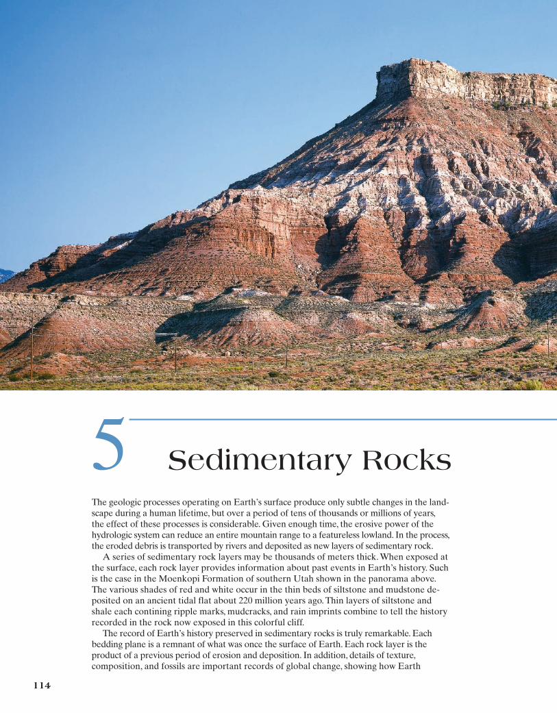
5 Sedimentary RocksThe geologic processes operating on Earth’s surface produce only subtle changes in the land-scape during a human lifetime, but over a period of tens of thousands or millions of years,the effect of these processes is considerable. Given enough time, the erosive power of the hydrologic system can reduce an entire mountain range to a featureless lowland. In the process,the eroded debris is transported by rivers and deposited as new layers of sedimentary rock.
A series of sedimentary rock layers may be thousands of meters thick. When exposed atthe surface, each rock layer provides information about past events in Earth’s history. Suchis the case in the Moenkopi Formation of southern Utah shown in the panorama above.The various shades of red and white occur in the thin beds of siltstone and mudstone de-posited on an ancient tidal flat about 220 million years ago. Thin layers of siltstone andshale each contining ripple marks, mudcracks, and rain imprints combine to tell the historyrecorded in the rock now exposed in this colorful cliff.
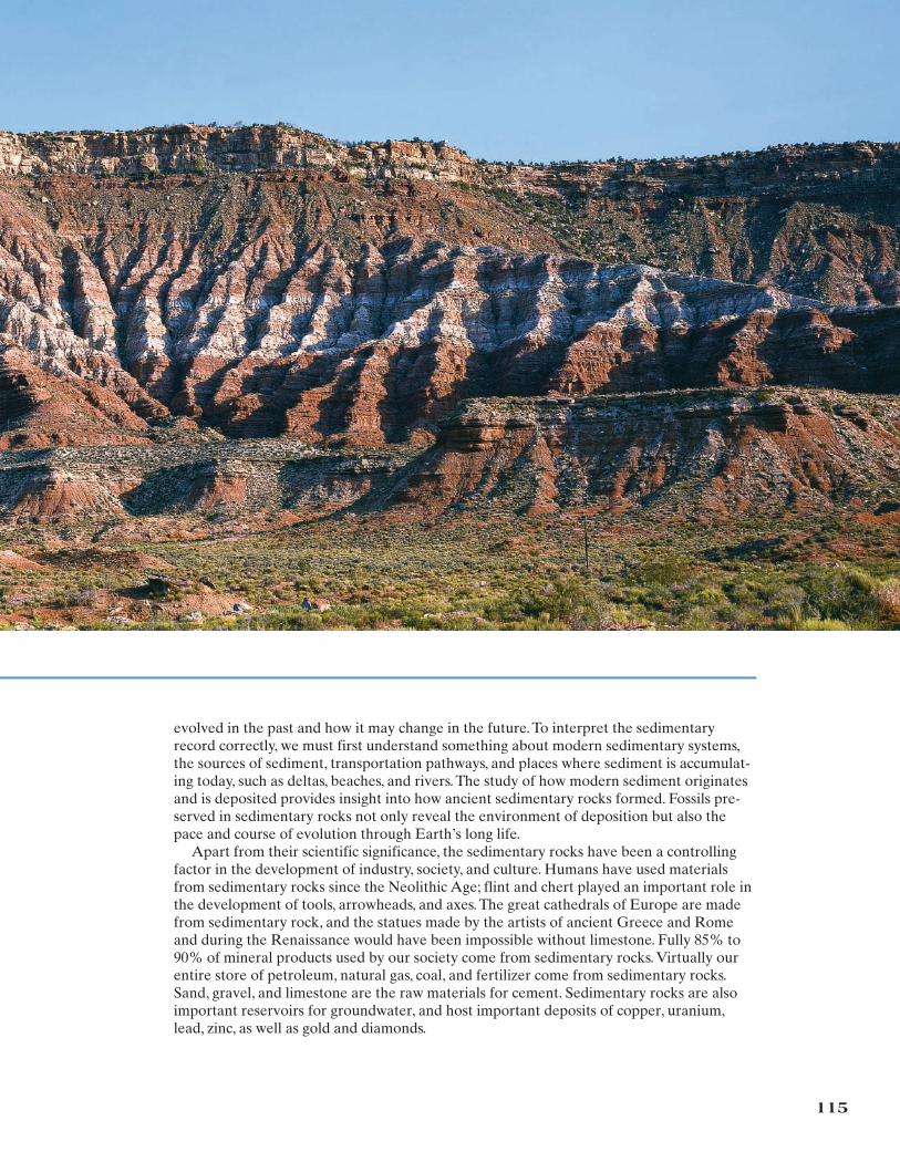
The record of Earth’s history preserved in sedimentary rocks is truly remarkable. Each bedding plane is a remnant of what was once the surface of Earth. Each rock layer is the product of a previous period of erosion and deposition. In addition, details of texture,composition, and fossils are important records of global change, showing how Earth
115
evolved in the past and how it may change in the future. To interpret the sedimentaryrecord correctly, we must first understand something about modern sedimentary systems,the sources of sediment, transportation pathways, and places where sediment is accumulat-ing today, such as deltas, beaches, and rivers. The study of how modern sediment originatesand is deposited provides insight into how ancient sedimentary rocks formed. Fossils pre-served in sedimentary rocks not only reveal the environment of deposition but also thepace and course of evolution through Earth’s long life.
Apart from their scientific significance, the sedimentary rocks have been a controllingfactor in the development of industry, society, and culture. Humans have used materialsfrom sedimentary rocks since the Neolithic Age; flint and chert played an important role inthe development of tools, arrowheads, and axes. The great cathedrals of Europe are madefrom sedimentary rock, and the statues made by the artists of ancient Greece and Romeand during the Renaissance would have been impossible without limestone. Fully 85% to90% of mineral products used by our society come from sedimentary rocks. Virtually ourentire store of petroleum, natural gas, coal, and fertilizer come from sedimentary rocks.Sand, gravel, and limestone are the raw materials for cement. Sedimentary rocks are alsoimportant reservoirs for groundwater, and host important deposits of copper, uranium,lead, zinc, as well as gold and diamonds.
THE NATURE OF SEDIMENTARY ROCKS
Sedimentary rocks form from fragments derived from other rocks and by precipitation from water. They typically occur in layers, or strata, separated one from the other by bedding planes and differences in composition.
Sedimentary rocks are probably more familiar than the other major rock types.Few people, however, are aware of the true nature and extent of sedimentaryrock bodies.
The constituents of sedimentary rocks are derived from the mechanical break-down and chemical decay of preexisting rocks. This sediment is compacted andcemented to form solid rock bodies. The original sediment can be composed ofvarious substances:
1. Fragments of other rocks and minerals, such as gravel in a river channel, sandon a beach, or mud in the ocean
2. Chemical precipitates, such as salt in a saline lake or gypsum in a shallow sea3. Organic materials formed by biochemical processes, such as vegetation in a
swamp, coral reefs, and calcium carbonate precipitated by in the ocean
Sedimentary rocks are important because they preserve a record of ancient land-scapes, climates, and mountain ranges, as well as the history of the erosion of Earth.In addition, fossils are found in abundance in sedimentary rocks younger than 600 million years and provide evidence of the evolution of life through time. Earth’sgeologic time scale was worked out using this record of sedimentary rocks and fossils.
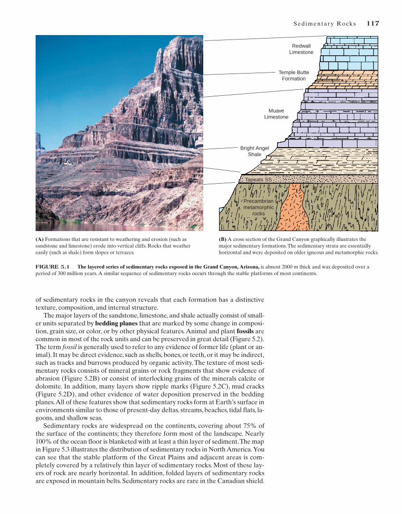
An excellent place to study the nature of sedimentary rocks is Arizona’s GrandCanyon (Figure 5.1), where many distinguishing features are well exposed. Theirmost obvious characteristic is that they occur in distinct layers, or strata (singularstratum), many of which are more than 100 m thick. Rock types that are resistantto weathering and erosion form cliffs, and nonresistant rocks erode into gentleslopes. From Figure 5.1, you should be able to recognize the major layers or for-mations in the geologic cross section shown in the diagram.The formations exposedin the Grand Canyon can be traced across much of northern Arizona and parts ofadjacent states. In fact, they cover an area of more than 250,000 km2. A close view
116
1. Sedimentary rocks form at Earth’s surface by the hydrologic system. Theirorigin involves the weathering of preexisting rock, transportation of thematerial away from the original site, deposition of the eroded material inthe sea or in some other sedimentary environment, followed by compactionand cementation.
2. Two main types of sedimentary rocks are recognized: (a) clastic rocks and(b) chemically precipitated rocks, including biochemical rocks.
3. Stratification is the most significant sedimentary structure. Other importantstructures include cross-bedding,graded bedding, ripple marks,and mud cracks.
4. The major sedimentary systems are (a) fluvial, (b) alluvial-fan, (c) eolian,(d) glacier, (e) delta, (f) shoreline, (g) organic-reef, (h) shallow-marine,(i) submarine fan, and (j) deep-marine.
5. Sedimentary rock layers can be grouped into formations, and formationscan be grouped into sequences that are bound by erosion surfaces. Theseformations and sequences form an important interpretive element in therock record.
6. Plate tectonics controls sedimentary systems by creating uplifted sourceareas, shaping depositional basins, and moving continents into different cli-mate zones.
MAJOR CONCEPTS
Sed imentary Rocks 117
of sedimentary rocks in the canyon reveals that each formation has a distinctivetexture, composition, and internal structure.
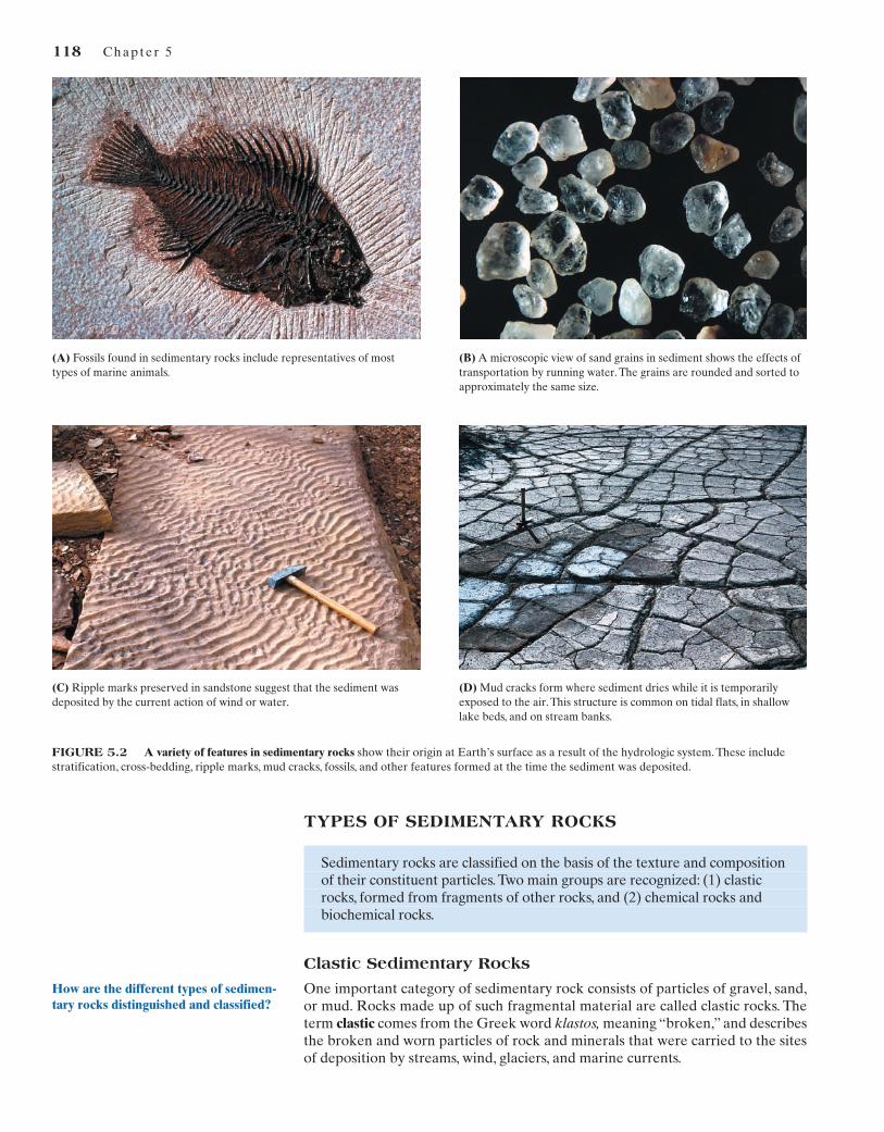
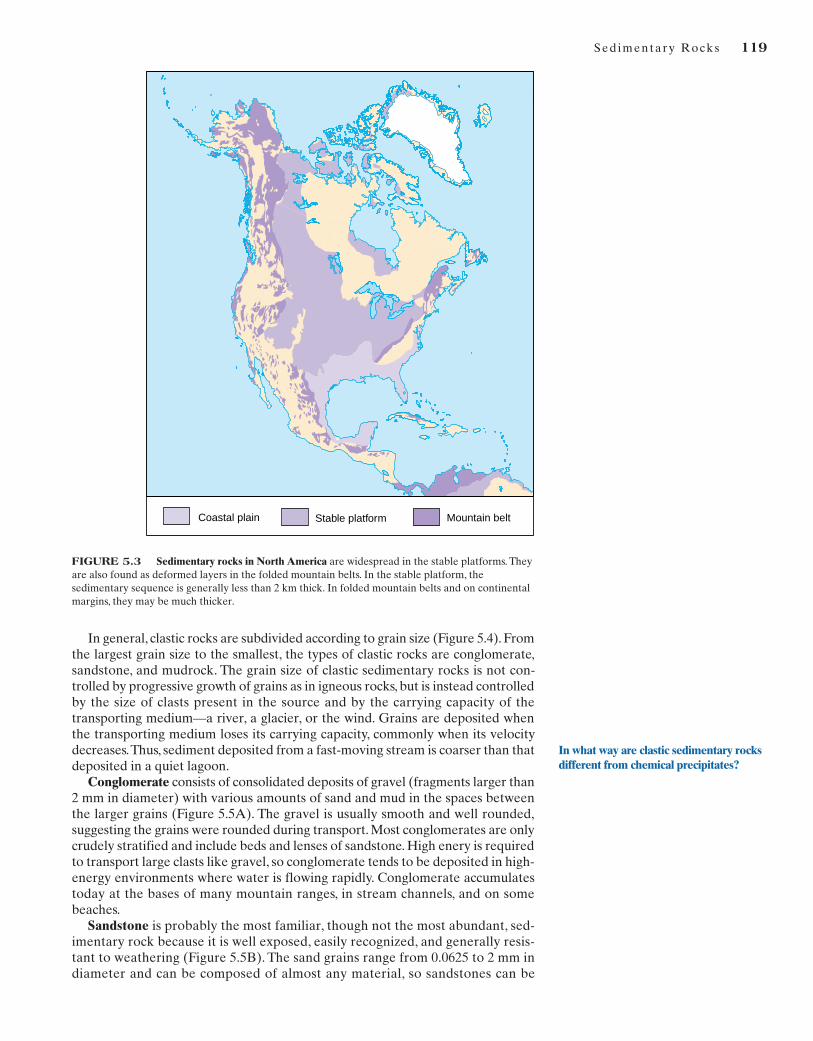
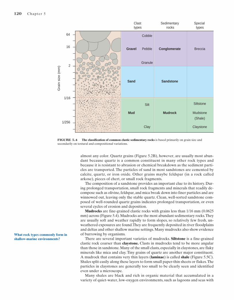
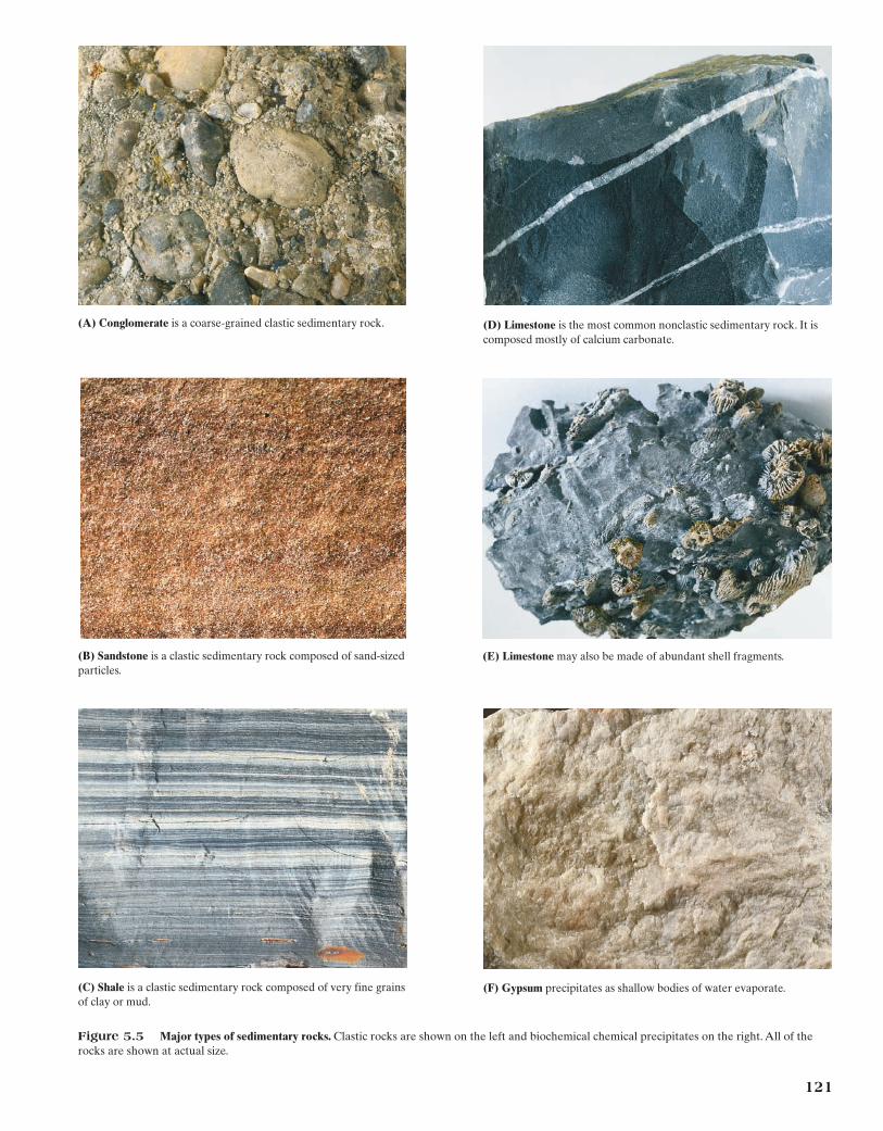
The major layers of the sandstone, limestone, and shale actually consist of small-er units separated by bedding planes that are marked by some change in composi-tion, grain size, or color, or by other physical features. Animal and plant fossils arecommon in most of the rock units and can be preserved in great detail (Figure 5.2).The term fossil is generally used to refer to any evidence of former life (plant or an-imal). It may be direct evidence, such as shells, bones, or teeth, or it may be indirect,such as tracks and burrows produced by organic activity.The texture of most sedi-mentary rocks consists of mineral grains or rock fragments that show evidence ofabrasion (Figure 5.2B) or consist of interlocking grains of the minerals calcite ordolomite. In addition, many layers show ripple marks (Figure 5.2C), mud cracks(Figure 5.2D), and other evidence of water deposition preserved in the beddingplanes.All of these features show that sedimentary rocks form at Earth’s surface inenvironments similar to those of present-day deltas, streams, beaches, tidal flats, la-goons, and shallow seas.
Sedimentary rocks are widespread on the continents, covering about 75% ofthe surface of the continents; they therefore form most of the landscape. Nearly100% of the ocean floor is blanketed with at least a thin layer of sediment.The mapin Figure 5.3 illustrates the distribution of sedimentary rocks in North America.Youcan see that the stable platform of the Great Plains and adjacent areas is com-pletely covered by a relatively thin layer of sedimentary rocks. Most of these lay-ers of rock are nearly horizontal. In addition, folded layers of sedimentary rocksare exposed in mountain belts. Sedimentary rocks are rare in the Canadian shield.
(A) Formations that are resistant to weathering and erosion (such assandstone and limestone) erode into vertical cliffs. Rocks that weathereasily (such as shale) form slopes or terraces.
(B) A cross section of the Grand Canyon graphically illustrates themajor sedimentary formations. The sedimentary strata are essentiallyhorizontal and were deposited on older igneous and metamorphic rocks.
Redwall Limestone
Temple Butte Formation
Muave Limestone
Bright Angel Shale
Tapeats SS
Precambrian metamorphic
rocks
FIGURE 5.1 The layered series of sedimentary rocks exposed in the Grand Canyon, Arizona, is almost 2000 m thick and was deposited over aperiod of 300 million years. A similar sequence of sedimentary rocks occurs through the stable platforms of most continents.
How are the different types of sedimen-tary rocks distinguished and classified?
118 Chapter 5
TYPES OF SEDIMENTARY ROCKS
Sedimentary rocks are classified on the basis of the texture and composition of their constituent particles.Two main groups are recognized: (1) clastic rocks, formed from fragments of other rocks, and (2) chemical rocks and biochemical rocks.
Clastic Sedimentary Rocks
One important category of sedimentary rock consists of particles of gravel, sand,or mud. Rocks made up of such fragmental material are called clastic rocks. Theterm clastic comes from the Greek word klastos, meaning “broken,” and describesthe broken and worn particles of rock and minerals that were carried to the sitesof deposition by streams, wind, glaciers, and marine currents.
(B) A microscopic view of sand grains in sediment shows the effects oftransportation by running water. The grains are rounded and sorted toapproximately the same size.
(C) Ripple marks preserved in sandstone suggest that the sediment wasdeposited by the current action of wind or water.
(A) Fossils found in sedimentary rocks include representatives of mosttypes of marine animals.
(D) Mud cracks form where sediment dries while it is temporarilyexposed to the air. This structure is common on tidal flats, in shallowlake beds, and on stream banks.
FIGURE 5.2 A variety of features in sedimentary rocks show their origin at Earth’s surface as a result of the hydrologic system. These includestratification, cross-bedding, ripple marks, mud cracks, fossils, and other features formed at the time the sediment was deposited.
Sed imentary Rocks 119
In general, clastic rocks are subdivided according to grain size (Figure 5.4). Fromthe largest grain size to the smallest, the types of clastic rocks are conglomerate,sandstone, and mudrock. The grain size of clastic sedimentary rocks is not con-trolled by progressive growth of grains as in igneous rocks, but is instead controlledby the size of clasts present in the source and by the carrying capacity of the transporting medium—a river, a glacier, or the wind. Grains are deposited whenthe transporting medium loses its carrying capacity, commonly when its velocitydecreases.Thus, sediment deposited from a fast-moving stream is coarser than thatdeposited in a quiet lagoon.
Conglomerate consists of consolidated deposits of gravel (fragments larger than2 mm in diameter) with various amounts of sand and mud in the spaces betweenthe larger grains (Figure 5.5A). The gravel is usually smooth and well rounded,suggesting the grains were rounded during transport. Most conglomerates are onlycrudely stratified and include beds and lenses of sandstone. High enery is requiredto transport large clasts like gravel, so conglomerate tends to be deposited in high-energy environments where water is flowing rapidly. Conglomerate accumulatestoday at the bases of many mountain ranges, in stream channels, and on somebeaches.
Sandstone is probably the most familiar, though not the most abundant, sed-imentary rock because it is well exposed, easily recognized, and generally resis-tant to weathering (Figure 5.5B). The sand grains range from 0.0625 to 2 mm indiameter and can be composed of almost any material, so sandstones can be
FIGURE 5.3 Sedimentary rocks in North America are widespread in the stable platforms. Theyare also found as deformed layers in the folded mountain belts. In the stable platform, thesedimentary sequence is generally less than 2 km thick. In folded mountain belts and on continentalmargins, they may be much thicker.
Coastal plain Stable platform Mountain belt
In what way are clastic sedimentary rocksdifferent from chemical precipitates?
120 Chapter 5
almost any color. Quartz grains (Figure 5.2B), however, are usually most abun-dant because quartz is a common constituent in many other rock types and because it is resistant to abrasion or chemical breakdown as the sediment parti-cles are transported. The particles of sand in most sandstones are cemented bycalcite, quartz, or iron oxide. Other grains maybe feldspar (in a rock calledarkose), pieces of chert, or small rock fragments.
The composition of a sandstone provides an important clue to its history. Dur-ing prolonged transportation, small rock fragments and minerals that readily de-compose such as olivine, feldspar, and mica break down into finer particles and arewinnowed out, leaving only the stable quartz. Clean, well-sorted sandstone com-posed of well-rounded quartz grains indicates prolonged transportation, or evenseveral cycles of erosion and deposition.
Mudrocks are fine-grained clastic rocks with grains less than 1/16 mm (0.0625mm) across (Figure 5.4). Mudrocks are the most abundant sedimentary rocks.Theyare usually soft and weather rapidly to form slopes, so relatively few fresh, un-weathered exposures are found.They are frequently deposited in river floodplainsand deltas and other shallow marine settings. Many mudrocks also show evidenceof burrowing by organisms.
There are several important varieties of mudrocks. Siltstone is a fine-grainedclastic rock coarser than claystone. Clasts in mudrocks tend to be more angularthan those in sandstone. Many of the small clasts, especially in claystones, are flakyminerals like mica and clay. Tiny grains of quartz are another major constituent.A mudrock that contains very thin layers (laminae) is called shale (Figure 5.5C).Shales split easily along these layers to form small paper-thin sheets or flakes.Theparticles in claystones are generally too small to be clearly seen and identifiedeven under a microscope.
Many shales are black and rich in organic material that accumulated in avariety of quiet-water, low-oxygen environments, such as lagoons and seas with
Conglomerate
Mudrock
Gravel
Clay
Silt
Granule
Pebble
Cobble
Mud
Breccia
Siltstone
Mudstone
(Shale)
Claystone
SandstoneSand
Special types
Clast types
Sedimentary rocks
Gra
insi
ze(m
m) 2
1/256
16
1/16
64
FIGURE 5.4 The classification of common clastic sedimentary rocks is based primarily on grain size andsecondarily on textural and compositional variations.
What rock types commonly form inshallow-marine environments?
121
(C) Shale is a clastic sedimentary rock composed of very fine grainsof clay or mud.
(A) Conglomerate is a coarse-grained clastic sedimentary rock.
(E) Limestone may also be made of abundant shell fragments.(B) Sandstone is a clastic sedimentary rock composed of sand-sizedparticles.
(D) Limestone is the most common nonclastic sedimentary rock. It iscomposed mostly of calcium carbonate.
(F) Gypsum precipitates as shallow bodies of water evaporate.
Figure 5.5 Major types of sedimentary rocks. Clastic rocks are shown on the left and biochemical chemical precipitates on the right. All of therocks are shown at actual size.
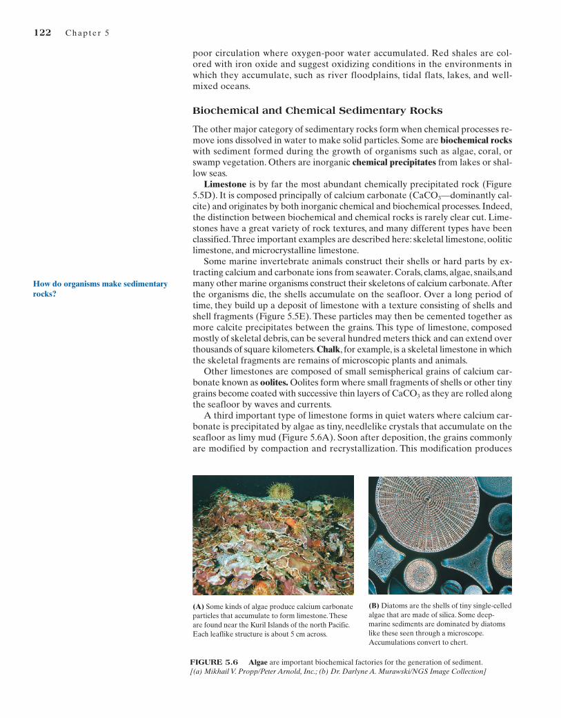
FIGURE 5.6 Algae are important biochemical factories for the generation of sediment.[(a) Mikhail V. Propp/Peter Arnold, Inc.; (b) Dr. Darlyne A. Murawski/NGS Image Collection]
122 Chapter 5
poor circulation where oxygen-poor water accumulated. Red shales are col-ored with iron oxide and suggest oxidizing conditions in the environments inwhich they accumulate, such as river floodplains, tidal flats, lakes, and well-mixed oceans.
Biochemical and Chemical Sedimentary Rocks
The other major category of sedimentary rocks form when chemical processes re-move ions dissolved in water to make solid particles. Some are biochemical rockswith sediment formed during the growth of organisms such as algae, coral, orswamp vegetation. Others are inorganic chemical precipitates from lakes or shal-low seas.
Limestone is by far the most abundant chemically precipitated rock (Figure5.5D). It is composed principally of calcium carbonate (CaCO3—dominantly cal-cite) and originates by both inorganic chemical and biochemical processes. Indeed,the distinction between biochemical and chemical rocks is rarely clear cut. Lime-stones have a great variety of rock textures, and many different types have beenclassified.Three important examples are described here: skeletal limestone, ooliticlimestone, and microcrystalline limestone.
Some marine invertebrate animals construct their shells or hard parts by ex-tracting calcium and carbonate ions from seawater. Corals, clams, algae, snails,andmany other marine organisms construct their skeletons of calcium carbonate.Afterthe organisms die, the shells accumulate on the seafloor. Over a long period oftime, they build up a deposit of limestone with a texture consisting of shells andshell fragments (Figure 5.5E). These particles may then be cemented together asmore calcite precipitates between the grains. This type of limestone, composedmostly of skeletal debris, can be several hundred meters thick and can extend overthousands of square kilometers. Chalk, for example, is a skeletal limestone in whichthe skeletal fragments are remains of microscopic plants and animals.
Other limestones are composed of small semispherical grains of calcium car-bonate known as oolites. Oolites form where small fragments of shells or other tinygrains become coated with successive thin layers of CaCO3 as they are rolled alongthe seafloor by waves and currents.
A third important type of limestone forms in quiet waters where calcium car-bonate is precipitated by algae as tiny, needlelike crystals that accumulate on theseafloor as limy mud (Figure 5.6A). Soon after deposition, the grains commonlyare modified by compaction and recrystallization. This modification produces
(A) Some kinds of algae produce calcium carbonateparticles that accumulate to form limestone. Theseare found near the Kuril Islands of the north Pacific.Each leaflike structure is about 5 cm across.
(B) Diatoms are the shells of tiny single-celledalgae that are made of silica. Some deep-marine sediments are dominated by diatomslike these seen through a microscope.Accumulations convert to chert.
How do organisms make sedimentaryrocks?
Sed imentary Rocks 123
microcrystalline limestone (or micrite), a rock with a dense, very fine-grained tex-ture (Figure 5.5D). Its individual crystals can be seen only under high magnifica-tion. Other types of carbonate grains may be cemented together by microcrystallinelimestone.
Inorganic limestone also is precipitated from springs and from the drippingwater in caves to form beautifully layered rocks called travertine.
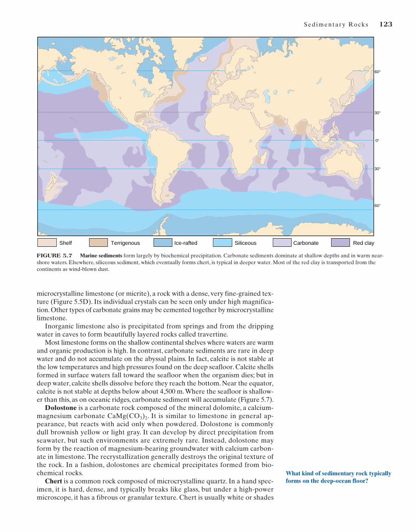
Most limestone forms on the shallow continental shelves where waters are warmand organic production is high. In contrast, carbonate sediments are rare in deepwater and do not accumulate on the abyssal plains. In fact, calcite is not stable atthe low temperatures and high pressures found on the deep seafloor. Calcite shellsformed in surface waters fall toward the seafloor when the organism dies; but indeep water, calcite shells dissolve before they reach the bottom. Near the equator,calcite is not stable at depths below about 4,500 m.Where the seafloor is shallow-er than this, as on oceanic ridges, carbonate sediment will accumulate (Figure 5.7).
Dolostone is a carbonate rock composed of the mineral dolomite, a calcium-magnesium carbonate CaMg(CO3)2. It is similar to limestone in general ap-pearance, but reacts with acid only when powdered. Dolostone is commonlydull brownish yellow or light gray. It can develop by direct precipitation fromseawater, but such environments are extremely rare. Instead, dolostone mayform by the reaction of magnesium-bearing groundwater with calcium carbon-ate in limestone. The recrystallization generally destroys the original texture ofthe rock. In a fashion, dolostones are chemical precipitates formed from bio-chemical rocks.
Chert is a common rock composed of microcrystalline quartz. In a hand spec-imen, it is hard, dense, and typically breaks like glass, but under a high-powermicroscope, it has a fibrous or granular texture. Chert is usually white or shades
30°
60°
0°
60°
30°
Shelf Siliceous Red clayCarbonateTerrigenous Ice-rafted
FIGURE 5.7 Marine sediments form largely by biochemical precipitation. Carbonate sediments dominate at shallow depths and in warm near-shore waters. Elsewhere, siliceous sediment, which eventually forms chert, is typical in deeper water. Most of the red clay is transported from thecontinents as wind-blown dust.
What kind of sedimentary rock typicallyforms on the deep-ocean floor?
124 Chapter 5
of gray, tan, green, or red. Several varieties are recognized on the basis of color,including flint (black) and jasper (red). Because it fractures to make sharp edges,it has been shaped by many ancient people to make arrowheads, spear points,and tools. Chert commonly occurs as irregular nodules in limestone or as distinctthin layers in marine sedimentary rocks. Some nodular chert precipitates frompore fluids, particularly in carbonate rocks. However, most chert probably formsbiochemically.
A distinctive type of deep-marine chert develops from deposits of siliceousshells of microscopic organisms, such as radiolaria and diatoms (Figure 5.6B).In the modern ocean, this kind of thinly bedded sediment dominates deep-ma-rine environments where these tiny shells rain onto the seafloor. Siliceous ma-rine sediment is thickest beneath regions of high biologic productivity. Com-pare the map of the biosphere (Figure 1.4) with the distribution of deep-marinechert (siliceous sediment in Figure 5.7), and you will discover that the siliceoussediment dominates in regions of high biologic productivity—continental mar-gins, in near-polar seas, and along the equator. Carbonate minerals do not ac-cumulate on the seafloor where the ocean is very deep because calcite is notstable at great depths (Figure 5.7). If the water is deep enough, a falling shellmade of carbonate is dissolved back into the seawater.
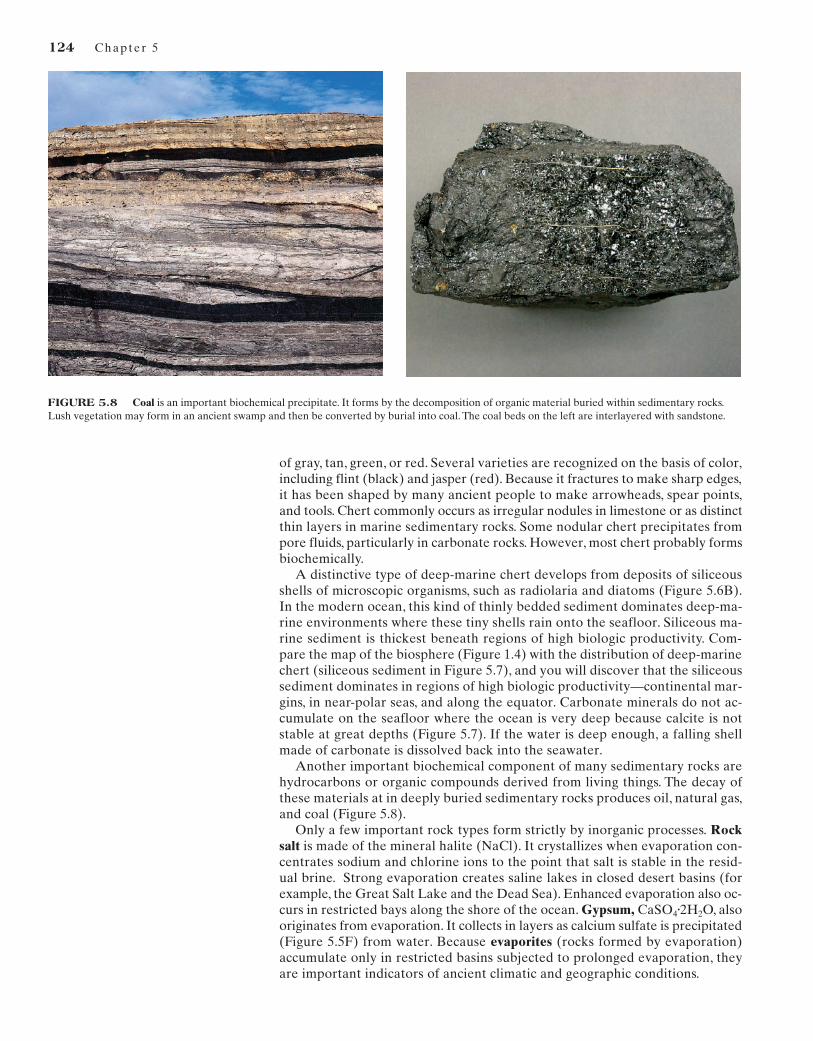
Another important biochemical component of many sedimentary rocks arehydrocarbons or organic compounds derived from living things. The decay ofthese materials at in deeply buried sedimentary rocks produces oil, natural gas,and coal (Figure 5.8).
Only a few important rock types form strictly by inorganic processes. Rocksalt is made of the mineral halite (NaCl). It crystallizes when evaporation con-centrates sodium and chlorine ions to the point that salt is stable in the resid-ual brine. Strong evaporation creates saline lakes in closed desert basins (forexample, the Great Salt Lake and the Dead Sea). Enhanced evaporation also oc-curs in restricted bays along the shore of the ocean. Gypsum, CaSO4
•2H2O, alsooriginates from evaporation. It collects in layers as calcium sulfate is precipitated(Figure 5.5F) from water. Because evaporites (rocks formed by evaporation)accumulate only in restricted basins subjected to prolonged evaporation, theyare important indicators of ancient climatic and geographic conditions.
FIGURE 5.8 Coal is an important biochemical precipitate. It forms by the decomposition of organic material buried within sedimentary rocks.Lush vegetation may form in an ancient swamp and then be converted by burial into coal. The coal beds on the left are interlayered with sandstone.
Sed imentary Rocks 125
SEDIMENTARY STRUCTURES
Sedimentary rocks commonly show layering and other structures that form as sediment is transported. The most important sedimentary structures are stratification, cross-bedding, graded bedding, ripple marks, and mud cracks.Primary sedimentary structures provide key information about the conditions under which the sediment accumulated.
Stratification
One of the most obvious characteristics of sedimentary rocks is that they occur indistinct layers expressed by changes in color, texture, and the way the differentrock units weather and erode. These layers are termed strata, or simply beds. Theplanes separating the layers are planes of stratification, or bedding planes. Strati-fication occurs on many scales and reflects the changes that occur during the for-mation of a sedimentary rock. Large-scale stratification is expressed by majorchanges in rock types (formations) (Figure 5.1). For example, cliffs of limestone orsandstone can alternate with slopes of weaker shale.
The origin of stratification is quite simple. Different layers form because ofsome change that occurs during the process of deposition. But there are manytypes of changes that occur and operate on many different scales, so the con-struction of a detailed history of sedimentary rocks presents a real challenge togeologists. Changes in weather, changes in the seasons, and changes in climateall can produce stratification in a sedimentary basin. Tectonic changes such as
WindWind
Wind
Migration of the dune
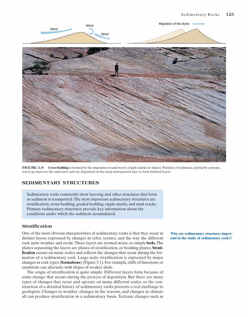
FIGURE 5.9 Cross-bedding is formed by the migration of sand waves (ripple marks or dunes). Particles of sediment, carried by currents,travel up and over the sand wave and are deposited on the steep downcurrent face to form inclined layers.
Why are sedimentary structures impor-tant in the study of sedimentary rocks?

uplift and subsidence of the continental platform, mountain building, and vol-canism all produce changes in material transported to the sea, and all can pro-duce different layers of sedimentary rock.
Cross-Bedding
Cross-bedding is a type of stratification in which the layers within a bed are inclinedat an angle to the upper and lower surfaces of the bed. The formation of cross-bedding is shown in Figure 5.9. As sand grains are moved by wind or water, theyform small ripples or large dunes. These sand waves range in scale from small rip-ples less than a centimeter high to giant sand dunes several hundred meters high.Typically, they are asymmetrical, with the gentle slope facing the moving current.As the particles migrate up and over the sand wave, they accumulate on the steepdowncurrent face and form inclined layers. The direction of flow of the ancientcurrents that formed a given set of cross-strata can be determined by measuring thedirection in which the strata are inclined.We can determine the patterns of ancientcurrent systems by mapping the direction of cross-bedding in sedimentary rocks.Moreover, the style of cross-bedding changes with the sediment supply and with theflow conditions at the depositional site.Thus, the details of an ancient environmentcan be interpreted from careful study of the type of cross-bedding.
Graded Bedding
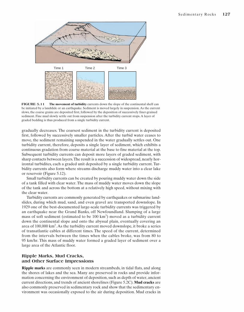
Another distinctive type of stratification, called graded bedding, displays a pro-gressive decrease in grain size upward through a bed (Figure 5.10). This type ofstratification commonly is produced on the deep-ocean floor by turbidity cur-rents, which transport sediment from the continental slope to adjacent deepocean forming bodies of rock called turbidites. A turbidity current is generatedby turbid (muddy) water, which, being denser than the surrounding clear water,sinks beneath it and moves rapidly down the continental slope (Figure 5.11).Thedenser, muddy water moves out along the bottom of the basin and can flow fora considerable distance, even along the flat surface of an abyssal floor. As a tur-bidity current moves across the flat floor of a basin, its velocity at any given point
What sedimentary structure forms froma turbidity current?
126 Chapter 5
Figure 5.10 Graded bedding is produced by turbidity currents. It occurs in widespread layers, each layer generally less than a meter thick.Slumps off the deep continental slopes commonly produce great thicknesses of graded layers, which can easily be distinguished from sedimentdeposited in most other environments.
Sed imentary Rocks 127
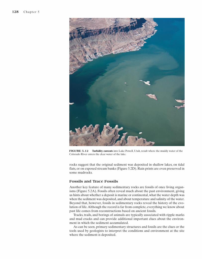
gradually decreases. The coarsest sediment in the turbidity current is depositedfirst, followed by successively smaller particles. After the turbid water ceases tomove, the sediment remaining suspended in the water gradually settles out. Oneturbidity current, therefore, deposits a single layer of sediment, which exhibits acontinuous gradation from coarse material at the base to fine material at the top.Subsequent turbidity currents can deposit more layers of graded sediment, withsharp contacts between layers.The result is a succession of widespread, nearly hor-izontal turbidites, each a graded unit deposited by a single turbidity current. Tur-bidity currents also form where streams discharge muddy water into a clear lakeor reservoir (Figure 5.12).
Small turbidity currents can be created by pouring muddy water down the sideof a tank filled with clear water. The mass of muddy water moves down the slopeof the tank and across the bottom at a relatively high speed, without mixing withthe clear water.
Turbidity currents are commonly generated by earthquakes or submarine land-slides, during which mud, sand, and even gravel are transported downslope. In1929 one of the best-documented large-scale turbidity currents was triggered byan earthquake near the Grand Banks, off Newfoundland. Slumping of a largemass of soft sediment (estimated to be 100 km3) moved as a turbidity currentdown the continental slope and onto the abyssal plain, eventually covering anarea of 100,000 km2. As the turbidity current moved downslope, it broke a seriesof transatlantic cables at different times. The speed of the current, determinedfrom the intervals between the times when the cables broke, was from 80 to 95 km/hr. This mass of muddy water formed a graded layer of sediment over alarge area of the Atlantic floor.
Ripple Marks, Mud Cracks, and Other Surface Impressions
Ripple marks are commonly seen in modern streambeds, in tidal flats, and alongthe shores of lakes and the sea. Many are preserved in rocks and provide infor-mation concerning the environment of deposition, such as depth of water, ancientcurrent directions, and trends of ancient shorelines (Figure 5.2C). Mud cracks arealso commonly preserved in sedimentary rock and show that the sedimentary en-vironment was occasionally exposed to the air during deposition. Mud cracks in
FIGURE 5.11 The movement of turbidity currents down the slope of the continental shelf canbe initiated by a landslide or an earthquake. Sediment is moved largely in suspension. As the currentslows, the coarse grains are deposited first, followed by the deposition of successively finer-grainedsediment. Fine mud slowly settle out from suspension after the turbidity current stops. A layer ofgraded bedding is thus produced from a single turbidity current.
Time 1 Time 2 Time 3
rocks suggest that the original sediment was deposited in shallow lakes, on tidalflats, or on exposed stream banks (Figure 5.2D). Rain prints are even preserved insome mudrocks.
Fossils and Trace Fossils
Another key feature of many sedimentary rocks are fossils of once living organ-isms (Figure 5.2A). Fossils often reveal much about the past environment, givingus hints about whether a deposit is marine or continental, what the water depth waswhen the sediment was deposited, and about temperature and salinity of the water.Beyond that, however, fossils in sedimentary rocks reveal the history of the evo-lution of life.Although the record is far from complete, everything we know aboutpast life comes from reconstructions based on ancient fossils.
Tracks, trails, and borings of animals are typically associated with ripple marksand mud cracks and can provide additional important clues about the environ-ment in which the sediment accumulated.
As can be seen, primary sedimentary structures and fossils are the clues or thetools used by geologists to interpret the conditions and environment at the sitewhere the sediment is deposited.
128 Chapter 5
FIGURE 5.12 Turbidity currents into Lake Powell, Utah, result where the muddy water of theColorado River enters the clear water of the lake.
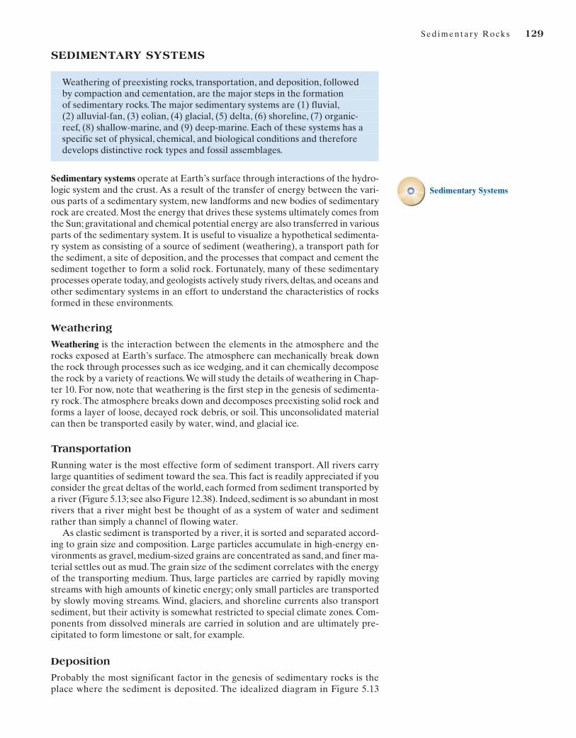
SEDIMENTARY SYSTEMS
Weathering of preexisting rocks, transportation, and deposition, followed by compaction and cementation, are the major steps in the formation of sedimentary rocks. The major sedimentary systems are (1) fluvial,(2) alluvial-fan, (3) eolian, (4) glacial, (5) delta, (6) shoreline, (7) organic-reef, (8) shallow-marine, and (9) deep-marine. Each of these systems has a specific set of physical, chemical, and biological conditions and therefore develops distinctive rock types and fossil assemblages.
Sedimentary systems operate at Earth’s surface through interactions of the hydro-logic system and the crust. As a result of the transfer of energy between the vari-ous parts of a sedimentary system, new landforms and new bodies of sedimentaryrock are created. Most the energy that drives these systems ultimately comes fromthe Sun; gravitational and chemical potential energy are also transferred in variousparts of the sedimentary system. It is useful to visualize a hypothetical sedimenta-ry system as consisting of a source of sediment (weathering), a transport path forthe sediment, a site of deposition, and the processes that compact and cement thesediment together to form a solid rock. Fortunately, many of these sedimentaryprocesses operate today, and geologists actively study rivers, deltas, and oceans andother sedimentary systems in an effort to understand the characteristics of rocksformed in these environments.
Weathering
Weathering is the interaction between the elements in the atmosphere and therocks exposed at Earth’s surface. The atmosphere can mechanically break downthe rock through processes such as ice wedging, and it can chemically decomposethe rock by a variety of reactions.We will study the details of weathering in Chap-ter 10. For now, note that weathering is the first step in the genesis of sedimenta-ry rock.The atmosphere breaks down and decomposes preexisting solid rock andforms a layer of loose, decayed rock debris, or soil. This unconsolidated materialcan then be transported easily by water, wind, and glacial ice.
Transportation
Running water is the most effective form of sediment transport. All rivers carrylarge quantities of sediment toward the sea. This fact is readily appreciated if youconsider the great deltas of the world, each formed from sediment transported bya river (Figure 5.13; see also Figure 12.38). Indeed, sediment is so abundant in mostrivers that a river might best be thought of as a system of water and sedimentrather than simply a channel of flowing water.
As clastic sediment is transported by a river, it is sorted and separated accord-ing to grain size and composition. Large particles accumulate in high-energy en-vironments as gravel, medium-sized grains are concentrated as sand, and finer ma-terial settles out as mud.The grain size of the sediment correlates with the energyof the transporting medium. Thus, large particles are carried by rapidly movingstreams with high amounts of kinetic energy; only small particles are transportedby slowly moving streams. Wind, glaciers, and shoreline currents also transportsediment, but their activity is somewhat restricted to special climate zones. Com-ponents from dissolved minerals are carried in solution and are ultimately pre-cipitated to form limestone or salt, for example.
Deposition
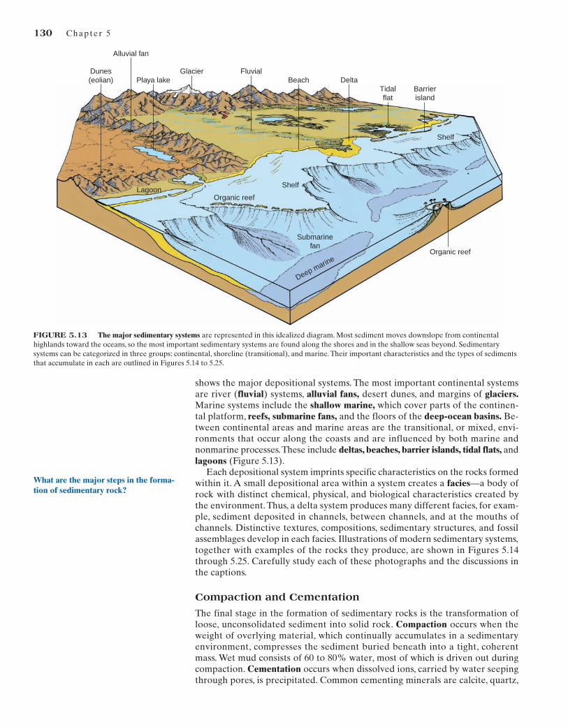
Probably the most significant factor in the genesis of sedimentary rocks is theplace where the sediment is deposited. The idealized diagram in Figure 5.13
Sed imentary Rocks 129
Sedimentary Systems
Dunes (eolian)
Alluvial fan
Playa lake Beach DeltaTidal flat
Organic reef
Organic reefLagoon
Barrier island
Shelf
Shelf
Submarine fan
Deep marine
Glacier Fluvial
FIGURE 5.13 The major sedimentary systems are represented in this idealized diagram. Most sediment moves downslope from continentalhighlands toward the oceans, so the most important sedimentary systems are found along the shores and in the shallow seas beyond. Sedimentarysystems can be categorized in three groups: continental, shoreline (transitional), and marine. Their important characteristics and the types of sedimentsthat accumulate in each are outlined in Figures 5.14 to 5.25.
130 Chapter 5
shows the major depositional systems. The most important continental systemsare river (fluvial) systems, alluvial fans, desert dunes, and margins of glaciers.Marine systems include the shallow marine, which cover parts of the continen-tal platform, reefs, submarine fans, and the floors of the deep-ocean basins. Be-tween continental areas and marine areas are the transitional, or mixed, envi-ronments that occur along the coasts and are influenced by both marine andnonmarine processes.These include deltas, beaches, barrier islands, tidal flats, andlagoons (Figure 5.13).
Each depositional system imprints specific characteristics on the rocks formedwithin it. A small depositional area within a system creates a facies—a body ofrock with distinct chemical, physical, and biological characteristics created bythe environment. Thus, a delta system produces many different facies, for exam-ple, sediment deposited in channels, between channels, and at the mouths ofchannels. Distinctive textures, compositions, sedimentary structures, and fossilassemblages develop in each facies. Illustrations of modern sedimentary systems,together with examples of the rocks they produce, are shown in Figures 5.14through 5.25. Carefully study each of these photographs and the discussions inthe captions.
Compaction and Cementation
The final stage in the formation of sedimentary rocks is the transformation ofloose, unconsolidated sediment into solid rock. Compaction occurs when theweight of overlying material, which continually accumulates in a sedimentaryenvironment, compresses the sediment buried beneath into a tight, coherentmass. Wet mud consists of 60 to 80% water, most of which is driven out duringcompaction. Cementation occurs when dissolved ions, carried by water seepingthrough pores, is precipitated. Common cementing minerals are calcite, quartz,
What are the major steps in the forma-tion of sedimentary rock?
131
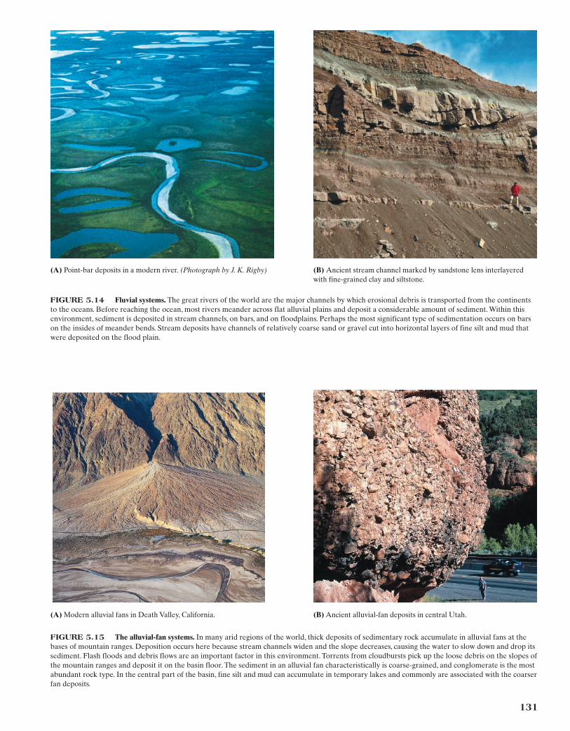
(A) Point-bar deposits in a modern river. (Photograph by J. K. Rigby) (B) Ancient stream channel marked by sandstone lens interlayeredwith fine-grained clay and siltstone.
FIGURE 5.14 Fluvial systems. The great rivers of the world are the major channels by which erosional debris is transported from the continentsto the oceans. Before reaching the ocean, most rivers meander across flat alluvial plains and deposit a considerable amount of sediment. Within thisenvironment, sediment is deposited in stream channels, on bars, and on floodplains. Perhaps the most significant type of sedimentation occurs on barson the insides of meander bends. Stream deposits have channels of relatively coarse sand or gravel cut into horizontal layers of fine silt and mud thatwere deposited on the flood plain.
(A) Modern alluvial fans in Death Valley, California. (B) Ancient alluvial-fan deposits in central Utah.
FIGURE 5.15 The alluvial-fan systems. In many arid regions of the world, thick deposits of sedimentary rock accumulate in alluvial fans at thebases of mountain ranges. Deposition occurs here because stream channels widen and the slope decreases, causing the water to slow down and drop itssediment. Flash floods and debris flows are an important factor in this environment. Torrents from cloudbursts pick up the loose debris on the slopes ofthe mountain ranges and deposit it on the basin floor. The sediment in an alluvial fan characteristically is coarse-grained, and conglomerate is the mostabundant rock type. In the central part of the basin, fine silt and mud can accumulate in temporary lakes and commonly are associated with the coarserfan deposits.
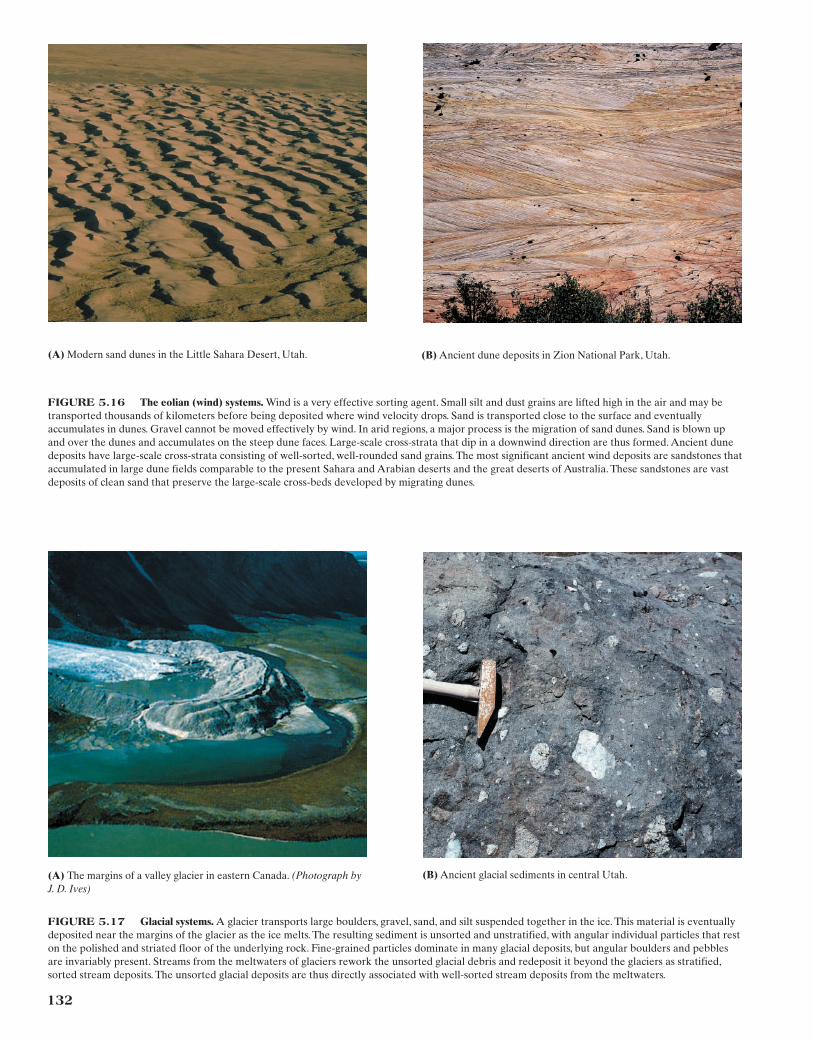
(A) Modern sand dunes in the Little Sahara Desert, Utah. (B) Ancient dune deposits in Zion National Park, Utah.
FIGURE 5.16 The eolian (wind) systems. Wind is a very effective sorting agent. Small silt and dust grains are lifted high in the air and may betransported thousands of kilometers before being deposited where wind velocity drops. Sand is transported close to the surface and eventuallyaccumulates in dunes. Gravel cannot be moved effectively by wind. In arid regions, a major process is the migration of sand dunes. Sand is blown upand over the dunes and accumulates on the steep dune faces. Large-scale cross-strata that dip in a downwind direction are thus formed. Ancient dunedeposits have large-scale cross-strata consisting of well-sorted, well-rounded sand grains. The most significant ancient wind deposits are sandstones thataccumulated in large dune fields comparable to the present Sahara and Arabian deserts and the great deserts of Australia. These sandstones are vastdeposits of clean sand that preserve the large-scale cross-beds developed by migrating dunes.
132
(A) The margins of a valley glacier in eastern Canada. (Photograph byJ. D. Ives)
(B) Ancient glacial sediments in central Utah.
FIGURE 5.17 Glacial systems. A glacier transports large boulders, gravel, sand, and silt suspended together in the ice. This material is eventuallydeposited near the margins of the glacier as the ice melts. The resulting sediment is unsorted and unstratified, with angular individual particles that reston the polished and striated floor of the underlying rock. Fine-grained particles dominate in many glacial deposits, but angular boulders and pebblesare invariably present. Streams from the meltwaters of glaciers rework the unsorted glacial debris and redeposit it beyond the glaciers as stratified,sorted stream deposits. The unsorted glacial deposits are thus directly associated with well-sorted stream deposits from the meltwaters.
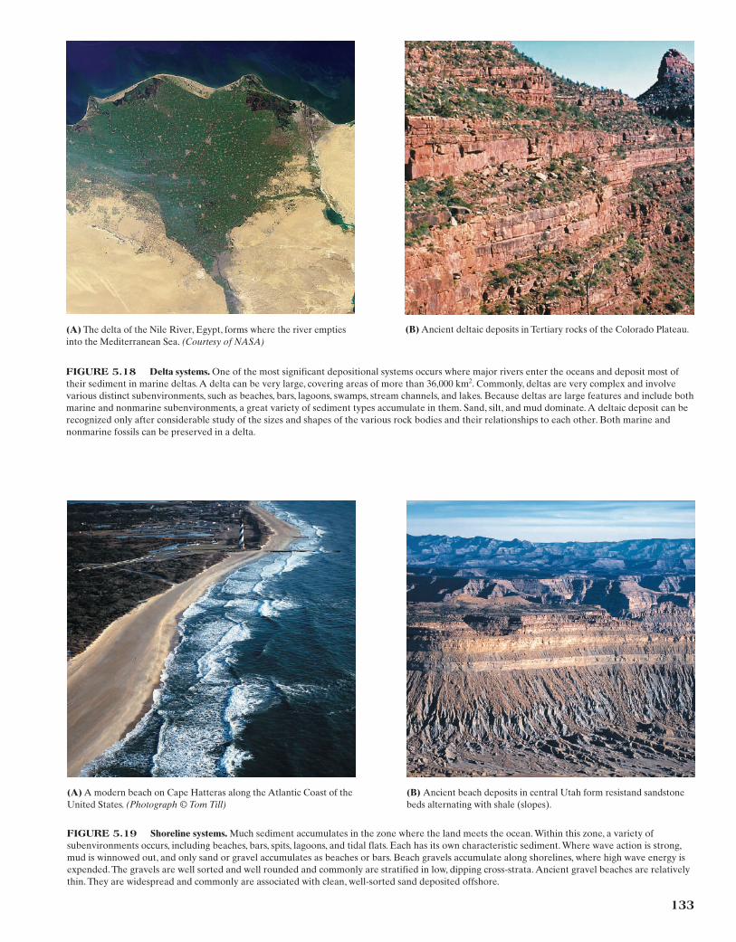
(A) The delta of the Nile River, Egypt, forms where the river emptiesinto the Mediterranean Sea. (Courtesy of NASA)
(B) Ancient deltaic deposits in Tertiary rocks of the Colorado Plateau.
FIGURE 5.18 Delta systems. One of the most significant depositional systems occurs where major rivers enter the oceans and deposit most oftheir sediment in marine deltas. A delta can be very large, covering areas of more than 36,000 km2. Commonly, deltas are very complex and involvevarious distinct subenvironments, such as beaches, bars, lagoons, swamps, stream channels, and lakes. Because deltas are large features and include bothmarine and nonmarine subenvironments, a great variety of sediment types accumulate in them. Sand, silt, and mud dominate. A deltaic deposit can berecognized only after considerable study of the sizes and shapes of the various rock bodies and their relationships to each other. Both marine andnonmarine fossils can be preserved in a delta.
(A) A modern beach on Cape Hatteras along the Atlantic Coast of theUnited States. (Photograph © Tom Till)
(B) Ancient beach deposits in central Utah form resistand sandstonebeds alternating with shale (slopes).
FIGURE 5.19 Shoreline systems. Much sediment accumulates in the zone where the land meets the ocean. Within this zone, a variety ofsubenvironments occurs, including beaches, bars, spits, lagoons, and tidal flats. Each has its own characteristic sediment. Where wave action is strong,mud is winnowed out, and only sand or gravel accumulates as beaches or bars. Beach gravels accumulate along shorelines, where high wave energy isexpended. The gravels are well sorted and well rounded and commonly are stratified in low, dipping cross-strata. Ancient gravel beaches are relativelythin. They are widespread and commonly are associated with clean, well-sorted sand deposited offshore.
133
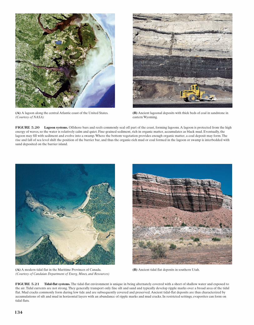
FIGURE 5.20 Lagoon systems. Offshore bars and reefs commonly seal off part of the coast, forming lagoons. A lagoon is protected from the highenergy of waves, so the water is relatively calm and quiet. Fine-grained sediment, rich in organic matter, accumulates as black mud. Eventually, thelagoon may fill with sediment and evolve into a swamp. Where the bottom vegetation provides enough organic matter, a coal deposit may form. Therise and fall of sea level shift the position of the barrier bar, and thus the organic-rich mud or coal formed in the lagoon or swamp is interbedded withsand deposited on the barrier island.
(A) A lagoon along the central Atlantic coast of the United States.(Courtesy of NASA)
(B) Ancient lagoonal deposits with thick beds of coal in sandstone ineastern Wyoming.
134
(A) A modern tidal flat in the Maritime Provinces of Canada.(Courtesy of Candaian Department of Energ, Mines, and Resources)
(B) Ancient tidal flat deposits in southern Utah.
FIGURE 5.21 Tidal-flat systems. The tidal-flat environment is unique in being alternately covered with a sheet of shallow water and exposed tothe air. Tidal currents are not strong. They generally transport only fine silt and sand and typically develop ripple marks over a broad area of the tidalflat. Mud cracks commonly form during low tide and are subsequently covered and preserved. Ancient tidal-flat deposits are thus characterized byaccumulations of silt and mud in horizontal layers with an abundance of ripple marks and mud cracks. In restricted settings, evaporites can form ontidal flats.
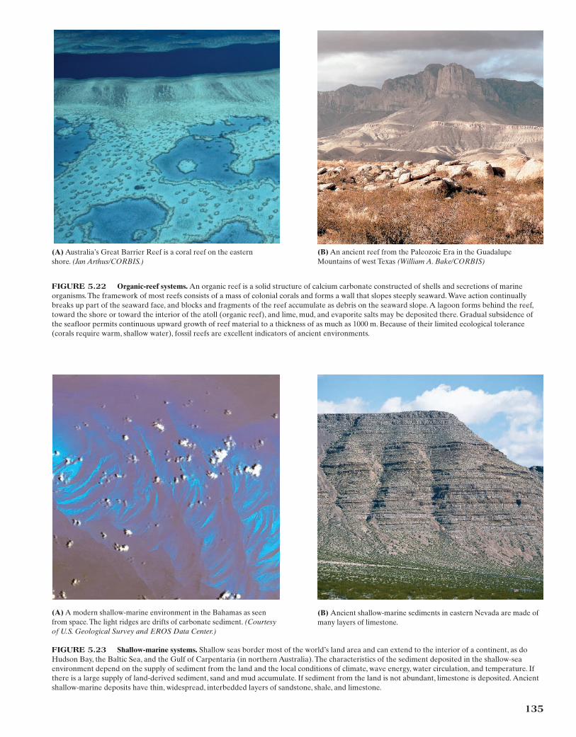
(A) Australia’s Great Barrier Reef is a coral reef on the easternshore. (Jan Arthus/CORBIS.)
(B) An ancient reef from the Paleozoic Era in the GuadalupeMountains of west Texas (William A. Bake/CORBIS)
FIGURE 5.22 Organic-reef systems. An organic reef is a solid structure of calcium carbonate constructed of shells and secretions of marineorganisms. The framework of most reefs consists of a mass of colonial corals and forms a wall that slopes steeply seaward. Wave action continuallybreaks up part of the seaward face, and blocks and fragments of the reef accumulate as debris on the seaward slope. A lagoon forms behind the reef,toward the shore or toward the interior of the atoll (organic reef), and lime, mud, and evaporite salts may be deposited there. Gradual subsidence ofthe seafloor permits continuous upward growth of reef material to a thickness of as much as 1000 m. Because of their limited ecological tolerance(corals require warm, shallow water), fossil reefs are excellent indicators of ancient environments.
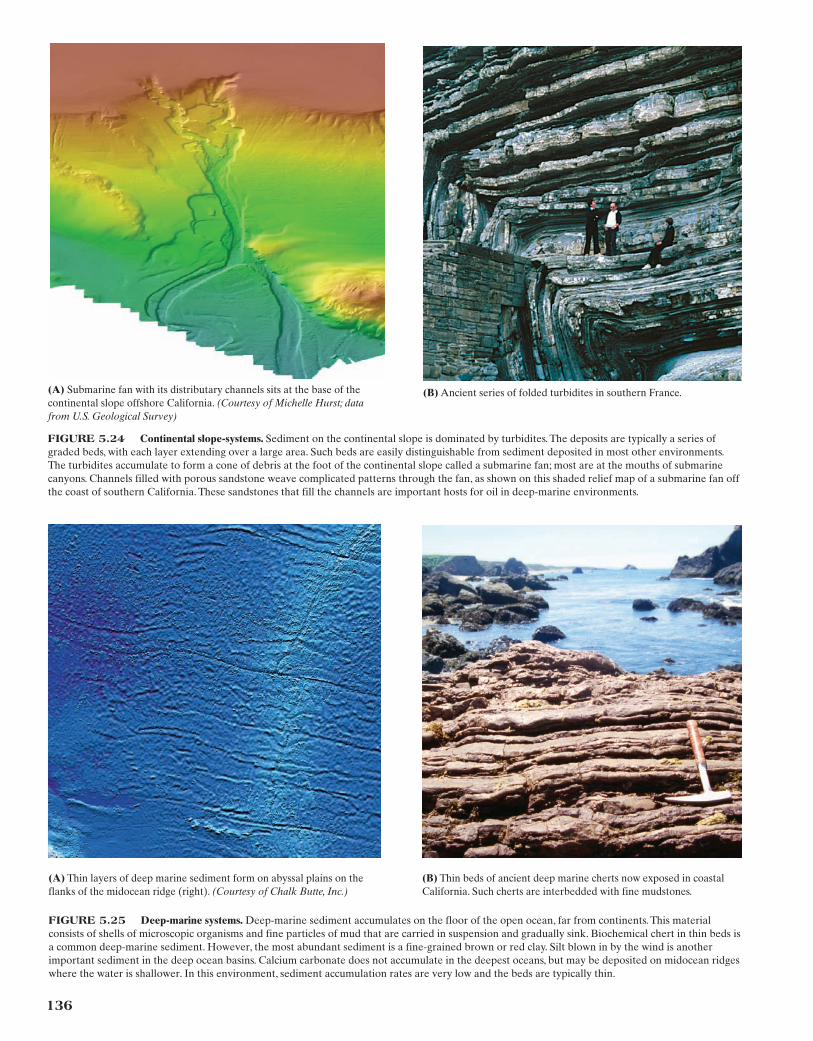
(A) A modern shallow-marine environment in the Bahamas as seenfrom space. The light ridges are drifts of carbonate sediment. (Courtesyof U.S. Geological Survey and EROS Data Center.)
(B) Ancient shallow-marine sediments in eastern Nevada are made ofmany layers of limestone.
FIGURE 5.23 Shallow-marine systems. Shallow seas border most of the world’s land area and can extend to the interior of a continent, as doHudson Bay, the Baltic Sea, and the Gulf of Carpentaria (in northern Australia). The characteristics of the sediment deposited in the shallow-seaenvironment depend on the supply of sediment from the land and the local conditions of climate, wave energy, water circulation, and temperature. Ifthere is a large supply of land-derived sediment, sand and mud accumulate. If sediment from the land is not abundant, limestone is deposited. Ancientshallow-marine deposits have thin, widespread, interbedded layers of sandstone, shale, and limestone.
135
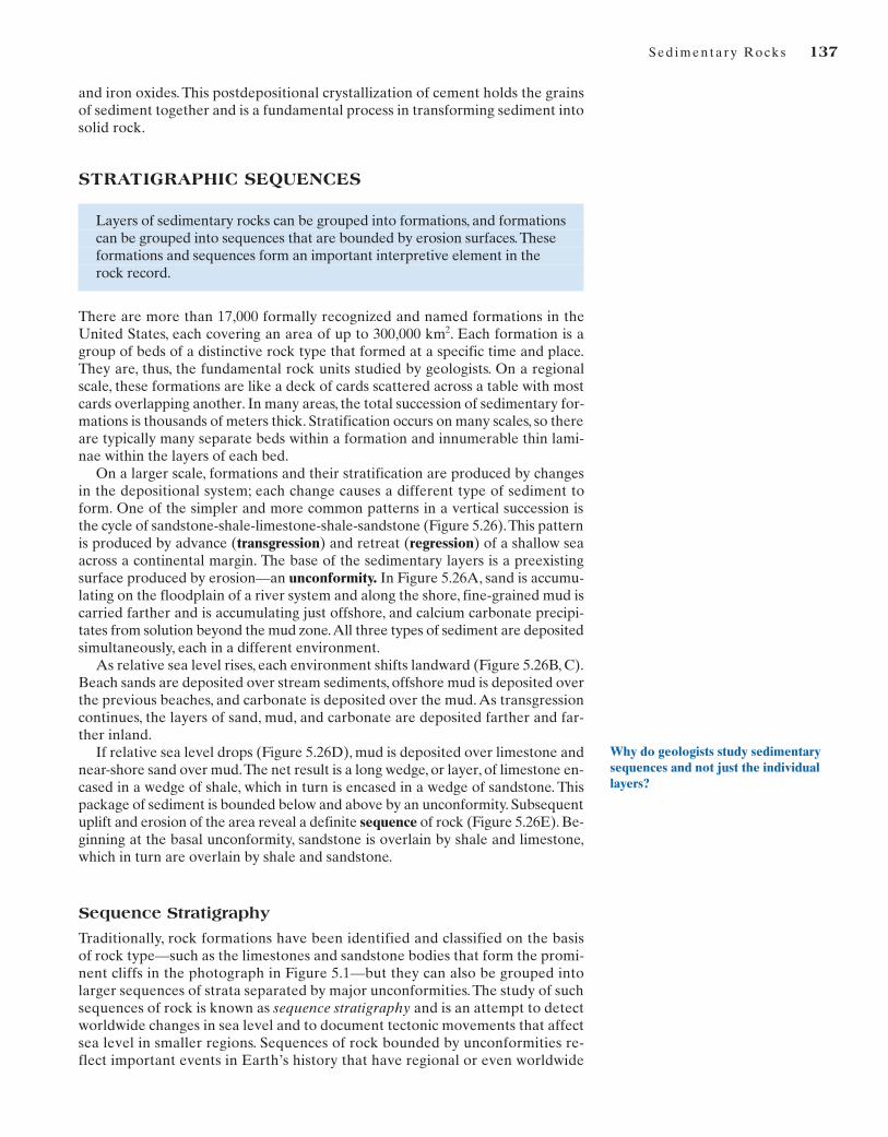
(A) Submarine fan with its distributary channels sits at the base of thecontinental slope offshore California. (Courtesy of Michelle Hurst; datafrom U.S. Geological Survey)
(B) Ancient series of folded turbidites in southern France.
FIGURE 5.24 Continental slope-systems. Sediment on the continental slope is dominated by turbidites. The deposits are typically a series ofgraded beds, with each layer extending over a large area. Such beds are easily distinguishable from sediment deposited in most other environments.The turbidites accumulate to form a cone of debris at the foot of the continental slope called a submarine fan; most are at the mouths of submarinecanyons. Channels filled with porous sandstone weave complicated patterns through the fan, as shown on this shaded relief map of a submarine fan offthe coast of southern California. These sandstones that fill the channels are important hosts for oil in deep-marine environments.
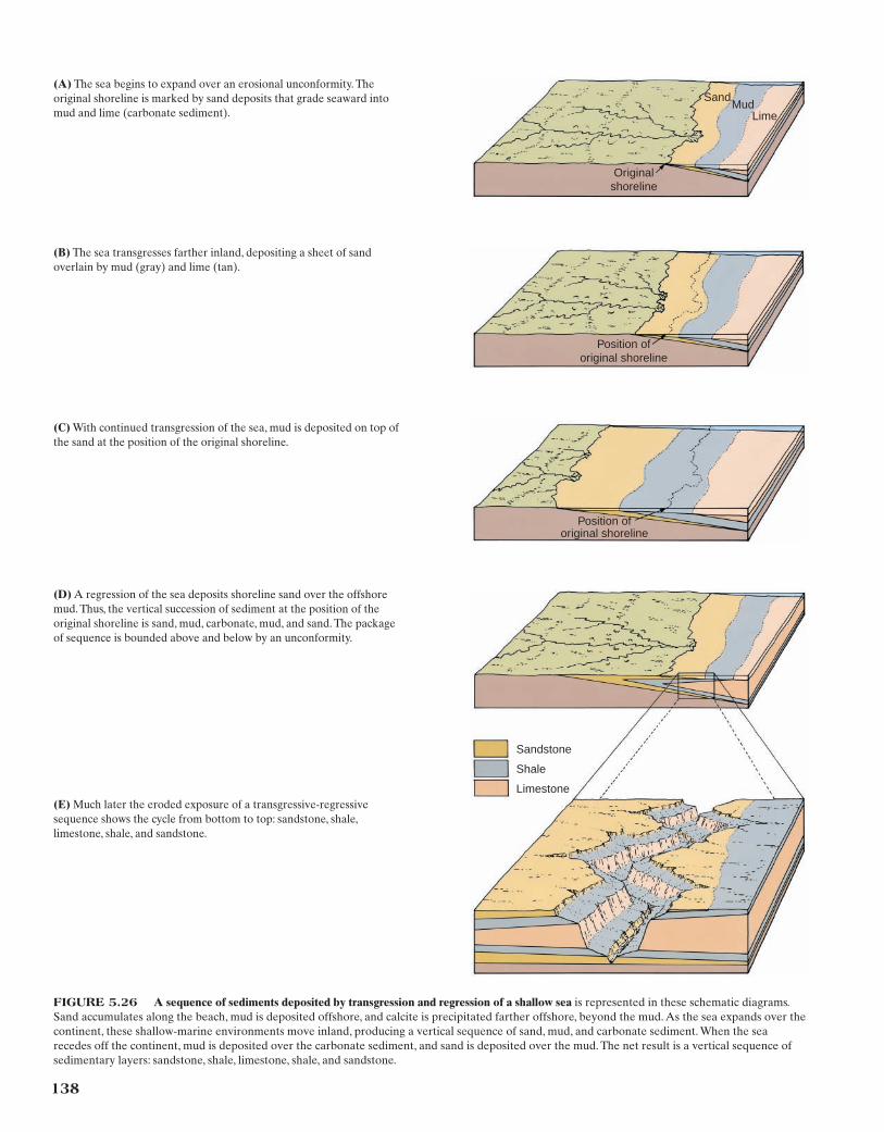
(A) Thin layers of deep marine sediment form on abyssal plains on theflanks of the midocean ridge (right). (Courtesy of Chalk Butte, Inc.)
(B) Thin beds of ancient deep marine cherts now exposed in coastalCalifornia. Such cherts are interbedded with fine mudstones.
FIGURE 5.25 Deep-marine systems. Deep-marine sediment accumulates on the floor of the open ocean, far from continents. This materialconsists of shells of microscopic organisms and fine particles of mud that are carried in suspension and gradually sink. Biochemical chert in thin beds isa common deep-marine sediment. However, the most abundant sediment is a fine-grained brown or red clay. Silt blown in by the wind is anotherimportant sediment in the deep ocean basins. Calcium carbonate does not accumulate in the deepest oceans, but may be deposited on midocean ridgeswhere the water is shallower. In this environment, sediment accumulation rates are very low and the beds are typically thin.
136
Sed imentary Rocks 137
and iron oxides. This postdepositional crystallization of cement holds the grainsof sediment together and is a fundamental process in transforming sediment intosolid rock.
STRATIGRAPHIC SEQUENCES
Layers of sedimentary rocks can be grouped into formations, and formations can be grouped into sequences that are bounded by erosion surfaces.These formations and sequences form an important interpretive element in the rock record.
There are more than 17,000 formally recognized and named formations in theUnited States, each covering an area of up to 300,000 km2. Each formation is agroup of beds of a distinctive rock type that formed at a specific time and place.They are, thus, the fundamental rock units studied by geologists. On a regionalscale, these formations are like a deck of cards scattered across a table with mostcards overlapping another. In many areas, the total succession of sedimentary for-mations is thousands of meters thick. Stratification occurs on many scales, so thereare typically many separate beds within a formation and innumerable thin lami-nae within the layers of each bed.
On a larger scale, formations and their stratification are produced by changesin the depositional system; each change causes a different type of sediment toform. One of the simpler and more common patterns in a vertical succession isthe cycle of sandstone-shale-limestone-shale-sandstone (Figure 5.26).This patternis produced by advance (transgression) and retreat (regression) of a shallow seaacross a continental margin. The base of the sedimentary layers is a preexistingsurface produced by erosion—an unconformity. In Figure 5.26A, sand is accumu-lating on the floodplain of a river system and along the shore, fine-grained mud iscarried farther and is accumulating just offshore, and calcium carbonate precipi-tates from solution beyond the mud zone.All three types of sediment are depositedsimultaneously, each in a different environment.
As relative sea level rises, each environment shifts landward (Figure 5.26B, C).Beach sands are deposited over stream sediments, offshore mud is deposited overthe previous beaches, and carbonate is deposited over the mud. As transgressioncontinues, the layers of sand, mud, and carbonate are deposited farther and far-ther inland.
If relative sea level drops (Figure 5.26D), mud is deposited over limestone andnear-shore sand over mud.The net result is a long wedge, or layer, of limestone en-cased in a wedge of shale, which in turn is encased in a wedge of sandstone. Thispackage of sediment is bounded below and above by an unconformity. Subsequentuplift and erosion of the area reveal a definite sequence of rock (Figure 5.26E). Be-ginning at the basal unconformity, sandstone is overlain by shale and limestone,which in turn are overlain by shale and sandstone.
Sequence Stratigraphy
Traditionally, rock formations have been identified and classified on the basisof rock type—such as the limestones and sandstone bodies that form the promi-nent cliffs in the photograph in Figure 5.1—but they can also be grouped intolarger sequences of strata separated by major unconformities. The study of suchsequences of rock is known as sequence stratigraphy and is an attempt to detectworldwide changes in sea level and to document tectonic movements that affectsea level in smaller regions. Sequences of rock bounded by unconformities re-flect important events in Earth’s history that have regional or even worldwide
Why do geologists study sedimentarysequences and not just the individuallayers?
138
Original shoreline
Position of original shoreline
Position of original shoreline
Sandstone
Shale
Limestone
SandMud
Lime
(B) The sea transgresses farther inland, depositing a sheet of sandoverlain by mud (gray) and lime (tan).
(D) A regression of the sea deposits shoreline sand over the offshoremud. Thus, the vertical succession of sediment at the position of theoriginal shoreline is sand, mud, carbonate, mud, and sand. The packageof sequence is bounded above and below by an unconformity.
(E) Much later the eroded exposure of a transgressive-regressivesequence shows the cycle from bottom to top: sandstone, shale,limestone, shale, and sandstone.
(C) With continued transgression of the sea, mud is deposited on top ofthe sand at the position of the original shoreline.
(A) The sea begins to expand over an erosional unconformity. Theoriginal shoreline is marked by sand deposits that grade seaward intomud and lime (carbonate sediment).
FIGURE 5.26 A sequence of sediments deposited by transgression and regression of a shallow sea is represented in these schematic diagrams.Sand accumulates along the beach, mud is deposited offshore, and calcite is precipitated farther offshore, beyond the mud. As the sea expands over thecontinent, these shallow-marine environments move inland, producing a vertical sequence of sand, mud, and carbonate sediment. When the searecedes off the continent, mud is deposited over the carbonate sediment, and sand is deposited over the mud. The net result is a vertical sequence ofsedimentary layers: sandstone, shale, limestone, shale, and sandstone.
Sed imentary Rocks 139
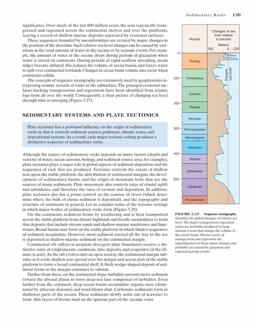
significance. Over much of the last 600 million years, the seas repeatedly trans-gressed and regressed across the continental shelves and over the platforms,leaving a record of shallow-marine deposits separated by erosional surfaces.
These sequences bounded by unconformities are created by major changes inthe position of the shoreline. Such relative sea level changes can be caused by vari-ations in the total amount of water in the oceans or by tectonic events. For exam-ple, the amount of water in the oceans drops during periods of glaciation whenwater is stored on continents. During periods of rapid seafloor spreading, oceanridges become inflated; this reduces the volume of ocean basins, and forces waterto spill over continental lowlands. Changes in ocean basin volume also occur whencontinents collide.
The concepts of sequence stratigraphy are extensively used by geophysicists in-terpreting seismic records of rocks in the subsurface. The principal erosional sur-faces marking transgressions and regressions have been identified from seismiclogs from all over the world. Consequently, a clear picture of changing sea levelthrough time is emerging (Figure 5.27).
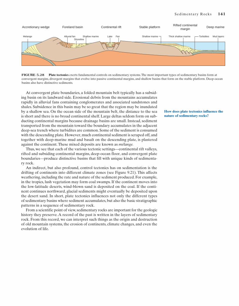
SEDIMENTARY SYSTEMS AND PLATE TECTONICS
Plate tectonics has a profound influence on the origin of sedimentary rocks in that it controls sediment sources, pathways, climate zones, and depositional systems. As a result, each major tectonic setting produces a distinctive sequence of sedimentary rocks.
Although the nature of sedimentary rocks depends on many factors (depth andvelocity of water, ocean currents, biology, and sediment source area, for example),plate tectonics plays a major role in global aspects of sediment deposition and thesequences of rock that are produced. Tectonics controls the extent of shallowseas upon the stable platform, the distribution of continental margins, the devel-opment of sedimentary basins, and the origin of mountain belts that are thesources of many sediments. Plate movement also controls rates of crustal upliftand subsidence, and therefore the rates of erosion and deposition. In addition,plate tectonics also has a prime control on the courses of rivers (which deter-mine where the bulk of clastic sediment is deposited), and the topography andstructure of continents in general. Let us consider some of the tectonic settingsin which major bodies of sedimentary rocks form (Figure 5.28).
On the continents, sediment forms by weathering and is then transportedacross the stable platform from distant highlands and locally accumulates to formthin deposits that include stream sands and shallow-marine mudstones and lime-stones. Broad basins may form on the stable platform in which thicker sequencesof sediment accumulate. However, most sediment carried all the way to the seais deposited as shallow-marine sediment on the continental margin.
Continental rift valleys at incipient divergent plate boundaries receive a dis-tinctive suite of conglomerate, sandstone, lake deposits, and evaporites (if the cli-mate is arid).As the rift evolves into an open seaway, the continental margin sub-sides as it cools; shallow seas spread over the margin and across part of the stableplatform to form a broad continental shelf.A thick wedge-shaped deposit of sed-iment forms as the margin continues to subside.
Farther from shore, on the continental slope, turbidity currents move sedimenttoward the abyssal plains to form deep-sea fans comprised of turbidites. Evenfarther from the continent, deep-ocean basins accumulate organic ooze (domi-nated by siliceous diatoms) and wind-blown dust. Carbonate sediments form inshallower parts of the oceans. These sediments slowly settle out of seawater toform thin layers of brown mud on the igneous part of the oceanic crust.
Pennsylvanian
500
Periods
Tertiary
Cretaceous
Jurassic
Permian
Triassic
Mississippian
Devonian
Silurian
Ordovician
Cambrian
Precambrian
Pre
sent
sea
leve
l
Changes of sea level relative to present
Meters350 –150
400
300
200
100
00
FIGURE 5.27 Sequence stratigraphyidentifies the global changes of relative sealevel. The major transgression-regressioncycles are probably produced by largetectonic events that change the volume ofthe ocean basins. Shorter cycles oftransgression and regression aresuperimposed on these major changes andprobably are caused by glaciation andregional tectonic events.
140
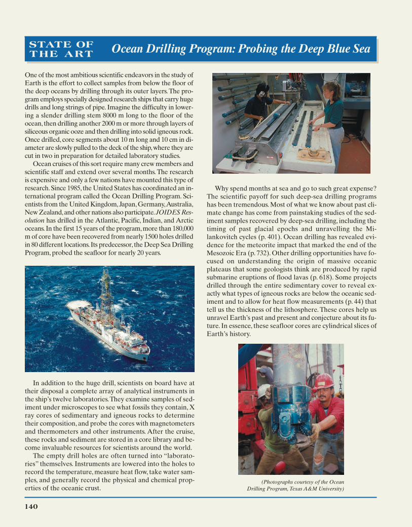
One of the most ambitious scientific endeavors in the study ofEarth is the effort to collect samples from below the floor ofthe deep oceans by drilling through its outer layers.The pro-gram employs specially designed research ships that carry hugedrills and long strings of pipe. Imagine the difficulty in lower-ing a slender drilling stem 8000 m long to the floor of theocean, then drilling another 2000 m or more through layers ofsiliceous organic ooze and then drilling into solid igneous rock.Once drilled, core segments about 10 m long and 10 cm in di-ameter are slowly pulled to the deck of the ship,where they arecut in two in preparation for detailed laboratory studies.
Ocean cruises of this sort require many crew members andscientific staff and extend over several months. The researchis expensive and only a few nations have mounted this type ofresearch.Since 1985, the United States has coordinated an in-ternational program called the Ocean Drilling Program. Sci-entists from the United Kingdom,Japan,Germany,Australia,New Zealand,and other nations also participate.JOIDES Res-olution has drilled in the Atlantic, Pacific, Indian, and Arcticoceans. In the first 15 years of the program,more than 180,000m of core have been recovered from nearly 1500 holes drilledin 80 different locations.Its predecessor, the Deep Sea DrillingProgram, probed the seafloor for nearly 20 years.
Why spend months at sea and go to such great expense?The scientific payoff for such deep-sea drilling programshas been tremendous. Most of what we know about past cli-mate change has come from painstaking studies of the sed-iment samples recovered by deep-sea drilling, including thetiming of past glacial epochs and unravelling the Mi-lankovitch cycles (p. 401). Ocean drilling has revealed evi-dence for the meteorite impact that marked the end of theMesozoic Era (p. 732). Other drilling opportunities have fo-cused on understanding the origin of massive oceanicplateaus that some geologists think are produced by rapidsubmarine eruptions of flood lavas (p. 618). Some projectsdrilled through the entire sedimentary cover to reveal ex-actly what types of igneous rocks are below the oceanic sed-iment and to allow for heat flow measurements (p. 44) thattell us the thickness of the lithosphere. These cores help usunravel Earth’s past and present and conjecture about its fu-ture. In essence, these seafloor cores are cylindrical slices ofEarth’s history.
STATE OFTHE ART Ocean Drilling Program: Probing the Deep Blue Sea
In addition to the huge drill, scientists on board have attheir disposal a complete array of analytical instruments inthe ship’s twelve laboratories.They examine samples of sed-iment under microscopes to see what fossils they contain, Xray cores of sedimentary and igneous rocks to determinetheir composition, and probe the cores with magnetometersand thermometers and other instruments. After the cruise,these rocks and sediment are stored in a core library and be-come invaluable resources for scientists around the world.
The empty drill holes are often turned into “laborato-ries” themselves. Instruments are lowered into the holes torecord the temperature, measure heat flow, take water sam-ples, and generally record the physical and chemical prop-erties of the oceanic crust.
(Photographs courtesy of the Ocean Drilling Program, Texas A&M University)
140
Sed imentary Rocks 141
At convergent plate boundaries, a folded mountain belt typically has a subsid-ing basin on its landward side. Erosional debris from the mountains accumulatesrapidly in alluvial fans containing conglomerates and associated sandstones andshales. Subsidence in this basin may be so great that the region may be inundatedby a shallow sea. On the ocean side of the mountain belt, the distance to the seais short and there is no broad continental shelf. Large deltas seldom form on sub-ducting continental margins because drainage basins are small. Instead, sedimenttransported from the mountain toward the boundary accumulates in the adjacentdeep-sea trench where turbidites are common. Some of the sediment is consumedwith the descending plate. However, much continental sediment is scraped off, andtogether with deep-marine mud and basalt on the descending plate, is plasteredagainst the continent. These mixed deposits are known as mélange.
Thus, we see that each of the various tectonic settings—continental rift valleys,rifted and subsiding continental margins, deep-ocean floor, and convergent plateboundaries—produce distinctive basins that fill with unique kinds of sedimenta-ry rock.
An indirect, but also profound, control tectonics has on sedimentation is thedrifting of continents into different climate zones (see Figure 9.21). This affectsweathering, including the rate and nature of the sediment produced. For example,in the tropics, lush vegetation may form coal swamps. If the continent moves intothe low-latitude deserts, wind-blown sand is deposited on the coal. If the conti-nent continues northward, glacial sediments might eventually be deposited uponthe desert sand. In short, plate tectonics influences not only the different types of sedimentary basins where sediment accumulates, but also the basic stratigraphicpatterns in a sequence of sedimentary rock.
From a scientific point of view, sedimentary rocks are important for the geologichistory they preserve. A record of the past is written in the layers of sedimentaryrock. From this record, we can interpret such things as the origin and destructionof old mountain systems, the erosion of continents, climate changes, and even theevolution of life.
Foreland basin Stable platform Deep marineAccretionary wedge Continental riftRifted continental
margin
Melange Alluvial fanShoreline
Shallow marine FanLake Shallow marine Thick shallow marine Turbidites Mud layers
FIGURE 5.28 Plate tectonics exerts fundamental controls on sedimentary systems. The most important types of sedimentary basins form atconvergent margins, divergent margins that evolve into passive continental margins, and shallow basins that form on the stable platform. Deep-oceanbasins also have distinctive sediments.
How does plate tectonics influence thenature of sedimentary rocks?
Slope Sys tems 142
142
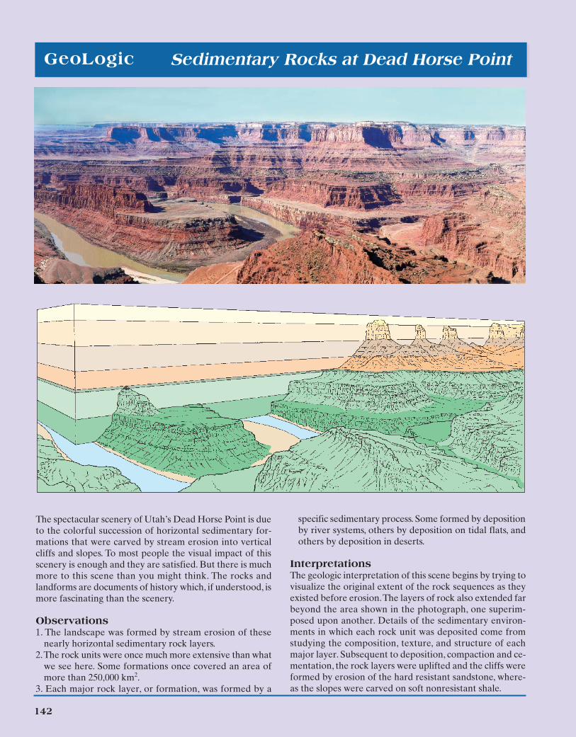
specific sedimentary process. Some formed by depositionby river systems, others by deposition on tidal flats, andothers by deposition in deserts.
InterpretationsThe geologic interpretation of this scene begins by trying tovisualize the original extent of the rock sequences as theyexisted before erosion.The layers of rock also extended farbeyond the area shown in the photograph, one superim-posed upon another. Details of the sedimentary environ-ments in which each rock unit was deposited come fromstudying the composition, texture, and structure of eachmajor layer. Subsequent to deposition, compaction and ce-mentation, the rock layers were uplifted and the cliffs wereformed by erosion of the hard resistant sandstone, where-as the slopes were carved on soft nonresistant shale.
GeoLogic Sedimentary Rocks at Dead Horse Point
The spectacular scenery of Utah’s Dead Horse Point is dueto the colorful succession of horizontal sedimentary for-mations that were carved by stream erosion into verticalcliffs and slopes. To most people the visual impact of thisscenery is enough and they are satisfied. But there is muchmore to this scene than you might think. The rocks andlandforms are documents of history which, if understood, ismore fascinating than the scenery.
Observations1. The landscape was formed by stream erosion of these
nearly horizontal sedimentary rock layers.2.The rock units were once much more extensive than what
we see here. Some formations once covered an area ofmore than 250,000 km2.
3. Each major rock layer, or formation, was formed by a
Sed imentary Rocks 143
KEY TERMS
alluvial fan (p. 130)
barrier island (p. 130)
beach (p. 130)
bed (p. 125)
bedding plane (p. 117)
biochemical rocks (p. 122)
cementation (p. 130)
chalk (p. 122)
chemical precipitate (p. 122)
chert (p. 123)
clastic (p. 118)
claystone (p. 120)
compaction (p. 130)
conglomerate (p. 119)
cross-bedding (p. 126)
deep-ocean basin (p. 130)
delta (p. 130)
dolostone (p. 123)
dune (p. 126)
eolian (p. 132)
evaporite (p. 124)
facies (p. 130)
fluvial (p. 130)
formation (p. 116)
fossil (p. 117)
glacier (p. 130)
graded bedding (p. 126)
gypsum (p. 124)
lagoon (p. 130)
lamina (p. 120)
limestone (p. 122)
mudrock (p. 120)
mud cracks (p. 127)
oolite (p. 122)
reef (p. 130)
regression (p. 137)
ripple marks (p. 127)
rock salt (p. 124)
sandstone (p. 119)
sand wave (p. 126)
sediment (p. 116)
sedimentary rock (p. 116)
sedimentary structure (p. 125)
sedimentary system (p. 129)
sequence (p. 137)
shale (p. 120)
shallow marine (p. 130)
siltstone (p. 120)
stratification (p. 125)
stratum (p. 116)
submarine fan (p. 130)
tidal flat (p. 130)
transgression (p. 137)
turbidite (p. 126)
turbidity current (p. 126)
unconformity (p. 137)
weathering (p. 129)
REVIEW QUESTIONS
1. List the characteristics that distinguish sedimentary rocksfrom igneous and metamorphic rocks.
2. What is the principal mineral in sandstone? Why does thismineral dominate?
3. What is the major difference between the various kinds ofclastic sedimentary rocks?
4. What is the principal cause of grain-size variations in clasticsediment?
5. How do limestones differ from clastic rocks?6. What is the mineral composition of limestone?7. How do evaporites form? How are they different from clas-
tic sedimentary rocks?
8. Show, by a series of sketches, the characteristics of stratifica-tion, cross-bedding, and graded bedding.
9. How could you recognize an ancient turbidity current de-posit now exposed in a mountain?
10. What rock types form in the following sedimentary systems:(a) delta, (b) lagoon, (c) alluvial fan, (d) eolian, (e) organicreef, and (f) deep marine?
11. How does plate tectonics control the character of sedimen-tary rocks deposited on a continental margin that is farfrom a modern plate boundary?
12. How does a transgression followed by a regression of thesea produce the vertical sequence sandstone, shale, lime-stone, shale, sandstone?
ADDITIONAL READINGS
Adams, A. D., W. S. MacKenzie, and C. Guilford. 1984. Atlas ofSedimentary Rocks Under the Microscope. New York: Wiley.
Blatt, H., and R.J. Tracy. 1996. Petrology: Igneous, Sedimentary,and Metamorphic. New York: Freeman.
Boggs, S. 2001. Principles of Sedimentology and Stratigraphy.Upper Saddle River, NJ: Prentice Hall.
Carozzi, A. V. 1993. Sedimentary Petrography. Englewood Cliffs,N.J.: Prentice Hall.
Open University. 1998. The Ocean Basins: Their Structure andEvolution. Oxford: Butterworth and Heinemann.
Prothero, D.R., and F. Schwab. 1996. Sedimentary Geology. NewYork: Freeman.
Reading, H. G. 1996. Sedimentary Environments: Processes, Fa-cies, and Stratigraphy. Oxford: Blackwell.
Tucker, M. E. 2001. Sedimentary Petrology. Oxford: Blackwell.
Earth’s Dynamic Systems WebsiteThe Companion Website at www.prenhall.com/hamblinprovides you with an on-line study guide and addition-
al resources for each chapter, including:
• On-line Quizzes (Chapter Review, Visualizing Geology,Quick Review, Vocabulary Flash Cards) with instant feedback
• Quantitative Problems
• Critical Thinking Exercises
• Web Resources
Earth’s Dynamic Systems CDExamine the CD that came with your text. It is designedto help you visualize and thus understand the concepts
in this chapter. It includes:
• Slide shows with more examples of sedimentary rocks andsedimentary environments
• Videos showing the formation of sedimentary structures
• A direct link to the Companion Website
MULTIMEDIA TOOLS


