Embed Size (px)
Citation preview

A ROAD MAP FOR 21st CENTURY GEOGRAPHY EDUCATIONGeography Education Research
Recommendations and Guidelines for Research in Geography Education
EditorsSarah Witham Bednarz
Susan Heffron
Niem Tu Huynh
A Report from the Geography Education Research Committee of the Road Map for 21st Century Geography Education Project

2 of 74
Road Map for 21st Century Geography Education Project
Geography Education Research
Recommendations and Guidelines for Research in Geography Education
Editors
Sarah Witham Bednarz, Susan Heffron, Niem Tu Huynh
Association of American Geographers
Washington, DC

3 of 74
Suggested citation: Bednarz, S.W., Heffron, S., & Huynh, N.T. (Eds.). (2013). A road map for 21st century geogra-phy education: Geography education research (A report from the Geography Education Research Committee of the Road Map for 21st Century Geography Education Project). Washington, DC: Association of American Geographers.
Information about the project and copies of reports are available at http://natgeoed.org/roadmap.
Copyright © 2013 by the National Geographic Society. All rights reserved.
This report was created by the Road Map for 21st Century
Geography Education Project.
Road Map for 21st Century Geography Education Project
Daniel C. Edelson, Principal Investigator Virginia M. Pitts, Project Director
The Road Map for 21st Century Geography Education Project is a collaboration between the National Geographic Society, the Association of American Geographers, the National Council for Geographic Education, and the American Geographical Society. The views expressed in the report are those of the authors and do not necessarily reflect the views of these organizations.
The Road Map for 21st Century Geography Education Project has been supported in part by the National Science Foundation under Grant No. DRL-1049437. Any opinions, findings, and conclusions or recommendations expressed in this material are those of the authors and do not necessarily reflect the views of the National Science Foundation.
The National Geographic Society is one of the world’s largest nonprofit scientific and educational organizations. Founded in 1888 to “increase and diffuse geographic knowledge,” the Society’s mission is to inspire people to care about the planet. It reaches more than 400 million people worldwide each month through its official journal, National Geographic, and other magazines; National Geographic Channel; television documentaries; music; radio; films; books; DVDs; maps; exhibitions; live events; school publishing programs; interactive media; and merchandise. National Geographic has funded more than 10,000 scientific research, conservation and exploration projects and supports an education program promoting geographic literacy.
The Association of American Geographers (AAG) is a nonprofit scientific, research, and educational society founded in 1904. Its 11,000 members from more than 60 countries share interests in the theory, methods, and practice of geography (including GIScience, geographic education, and geographic technologies). The AAG pursues its mission through its many conferences, scholarly publications, research projects, educational programs, topical specialty groups, and its extensive international network of colleagues and organizational partnerships, which encompass professionals working across public, private, and academic sectors all around the world.
The National Council for Geographic Education (NCGE) works to enhance the quality, quantity, and status of geography teaching and learning in primary, secondary, university, and informal educational settings. It develops and promotes curricular materials and two journals, fosters best practices in pedagogy and geotechnology, connects educators through online communication and through its annual conference, supports research in geographic education, recognizes exceptional supporters and teachers of geography, and collaborates with other organizations that have similar goals.
The American Geographical Society is an organization of professional geographers and other devotees of geography who share a fascination with the subject and a recognition of its importance. Most Fellows of the Society are Americans, but among them have always been a significant number of Fellows from around the world. The Society encourages activities that expand geographical knowledge, and it has a well-earned reputation for presenting and interpreting that knowledge so that it can be understood and used not just by geographers but by others as well—especially policy makers. It is the oldest nationwide geographical organization in the United States. Its priorities and programs have constantly evolved with the times, but the Society’s tradition of service to the U.S. government, business community, and nation-at-large has continued unchanged.

4 of 74
Geography Education Research Committee
Sarah Witham Bednarz, Chair Texas A&M University
Susan Heffron, Co-Chair Association of American Geographers
Niem Tu Huynh, Research Coordinator Association of American Geographers
Margaret Smith Crocco, University of Iowa
Richard A. Duschl, The Pennsylvania State University
David Lambert, University of London
Lynn S. Liben, The Pennsylvania State University
William Penuel, University of Colorado Boulder
Eui-kyung Shin, Northern Illinois University
Diana Stuart Sinton, University of Redlands
Michael Solem, Association of American Geographers
Joseph P. Stoltman, Western Michigan University
David Uttal, Northwestern University

5 of 74
Project Steering Committee
Daniel C. Edelson, Principal Investigator and Chair, Assessment Committee
Virginia M. Pitts, Project Director
Susan Heffron, Association of American Geographers and Co-Chair, Geography Education Research Committee
Doug Richardson Association of American Geographers
Jerome E. Dobson, American Geographical Society and Study Director, Public Understanding and Values Study
Kristin Alvarez National Council for Geographic Education
Joseph Kerski National Council for Geographic Education
Robert Dulli National Geographic Society
Sarah Witham Bednarz, Chair Geography Education Research Committee
Emily M. Schell, Chair Instructional Materials and Professional Development Committee
Kathleen J. Roth, Co-Chair Instructional Materials and Professional Development Committee
Richard J. Shavelson, Co-Chair Assessment Committee
Project Advisory Board
Gilbert M. Grosvenor, Chair National Geographic Society
Harm de Blij, Michigan State University
Richard G. Boehm, Texas State University-San Marcos
Barbara Chow, The William and Flora Hewlett Foundation
Jack Dangermond, Esri
Michael F. Goodchild, University of California, Santa Barbara
Brian McClendon, Google
Alexander B. Murphy, University of Oregon
M. Duane Nellis, University of Idaho
Trevor Packer, The College Board
Lee Schwartz

6 of 74
Table of Contents
Executive Summary ............................................................................ 7
Preface ............................................................................................... 10
Chapter 1: Context and Goals for the Road Map for 21st Century Geography Education Project ....................................... 16
The State of Geography Education in the United States
The Importance of Geography Education
The Need for a “Road Map” for Geography Education
Establishing a Destination: Goals for K–12 Geography Education
Describing the Destination: Effectiveness and Balance
Mapping a Bright Future
Chapter 2: Improving Research in Geography Education ................... 26
Research in Education as a Model for Geography Education
Crafting an Agenda in Geography Education
Chapter 3: Review of Geography Education Research ........................ 32
Status and Characteristics of Research in Geography Education
Research on Key Research Questions for Geography Education
Chapter 4: Building Capacity in Geography Education Research ....... 48
Strategy 1: Coordinate Research
Strategy 2: Develop Lines of Research
Examples of Lines of Research
Chapter 5: Geography Education Research Committee Recommendations .............................................................................. 56
Recommendations Focused on Charge 1
Recommendations Focused on Charge 2
Appendix A: Geography Education Research Committee Biographies ........................................................................................ 62
References .......................................................................................... 64
In the online version of this report, the icon on the lower left corner of the following pages will bring you back to this Table of Contents.

PrefaceContext and
GoalsBuilding Capacity
Research Review Appendix A References
Improving Research Recommendations
Executive Summary
7 of 74The Road Map Project | Geography Education Research Report | Executive Summary
Executive Summary
Introduction
In our rapidly changing, interdependent, and complex world, the importance of “the geographic advantage” (Hanson, 2004) and geography education is evident. Geography education provides critical preparation for civic life and careers in the 21st century. It also is es-sential for postsecondary study in a wide range of fields from marketing and environmental science to inter-national affairs and civil engineering. In the modern world, every member of society increasingly is called on to make decisions that have far-reaching consequences. Geography education helps prepare people to make these decisions.
Yet the current state of geography education in the United States is a concern. Although examples of excellence in geography education can be identified in every part of the country, they are the exception. More typically, the amount of geography instruction that stu-dents receive, the preparation of their teachers to teach geography, and the quality of instructional materials are inadequate to prepare students for the demands of the modern world.
Assessments of geographic concepts and skills confirm the failure of our educational system to provide students with an adequate understanding of geography. The 2010 National Assessment of Educational Progress (NAEP), known as “The Nation’s Report Card,” indicated that the overwhelming majority of American students are geographically illiterate (National Center for Education Statistics, 2011). It found that fewer
than 30% of American students were proficient in geography, meaning that they were able to perform at the level that is expected for their grade. More than 70% of high school graduates are not prepared to do the ordinary geographic thinking required in the course of caring for themselves and their families, making conse-quential decisions in the workplace, and participating in the democratic process.
We need better and more research before we can un-derstand even the most fundamental ways individuals develop proficiency in geography. The current state of geography education across the United States is a threat to our social, political, and economic well-being.
A Road Map for 21st Century Geography Education: Geography Education Research
The Road Map for 21st Century Geography Education Project focuses special attention on the practices of thinking geographically and doing geography, that is, the behaviors that comprise geographic inquiry and problem solving. The project adopts the learn-ing goals of the second edition of Geography for Life: National Geography Standards, Second Edition (Heffron & Downs, 2012) to provide a structure outlining what students must know and what they must be able to do to be geographically proficient.
This report focuses on two questions, posed as charges to the Geography Education Research Committee: (1) What areas of research will be most effective in im-proving geography education at a large scale? (2) What strategies and methodologies can relevant
research communities develop and adopt to maximize the cumulative impact of education research in geography?
The first question is addressed in Chapter 2. This Committee suggests two strategies to improve geography education research: (1) careful consideration of education research in related fields, including science and math-ematics education, more specifically, research in learning progressions or trajectories and related instructional inter-ventions; and (2) creation of a framework for geography education research. The framework consists of two parts: the practices of geography and four key research ques-tions. The geographic practices, which Geography for Life argues are essential to learning and thinking proficiently in geography, are:
• formulating geographic questions;
• acquiring, organizing, and analyzing geographic
information; and
• explaining and communicating geographic pat-
terns and processes.
To understand in depth how students learn each of these geographic practices, four education-related key research questions are proposed. These questions are ap-plicable to geography learners of all ages and educational backgrounds, whether they are engaged through schools or informal communities. The four key research ques-tions are: (1) How do geographic knowledge, skills, and practices develop across individuals, settings, and time? (2) How do geographic knowledge, skills, and practices develop across the different elements of geography? (3) What supports or promotes the development of geo-graphic knowledge, skills, and practices? (4) What is nec-essary to support the effective and broad implementation

PrefaceContext and
GoalsBuilding Capacity
Research Review Appendix A References
Improving Research Recommendations
Executive Summary
8 of 74The Road Map Project | Geography Education Research Report | Executive Summary
of the development of geographic knowledge, skills, and practices? Together, the practices of geography and key research questions provide an agenda and direction for geography education research.
The second question posed to the Committee, “What strategies and methodologies can relevant research com-munities develop and adopt to maximize the cumulative impact of education research in geography?” is addressed in Chapter 4. The Committee recommends connecting the relatively small community of geographers and others who conduct research in geography education with the broader community of scholars from the learning sci-ences, education, and related fields. This cooperation and collaboration will inform, assist, and enable more genera-tive activities such as developing a suite of exemplars that can be used in geography and other fields. It also will encourage studies that align to the key research questions suggested previously; are situated in a problem context; focus on the core ideas, knowledge, skills, and practices of geography; draw from research about cross-cutting themes and foundational concepts from other disciplines; and use common tasks, measures, and assessments.
Recommendations
The report concludes with 13 recommendations to improve research in geography education and, thus, to develop a more geographically proficient and liter-ate society.
The Committee’s recommendations are organized around the two key charges to the Geography Education Research Committee. A hierarchical order of recommendations is not implied as both charges are equally important. The Committee leaves it to the
individuals and groups reading and responding to this report to prioritize the recommendations.
Recommendations Focused on Charge 1
What areas of research will be most effective in improving geography education at a large scale?
Recommendation 1
The Committee recommends that geography
education researchers engage in systematic
efforts to identify learning progressions in
geography both within and across grade bands
(e.g., grades K–4, 5-8, 9-12).
Recommendation 2
The Committee recommends research that
examines the components and characteristics of
exemplary geography curricula.
Recommendation 3
The Committee recommends research to
investigate the characteristics of effective
geography teaching.
Recommendation 4
The Committee recommends research about
fieldwork and its impact on learning geography
knowledge, skills, and practices.
Recommendation 5
The Committee recommends that research about
teacher preparation in geography be conducted
with the goal of determining what is needed to
produce educators able to understand and teach
for student mastery of the content and practices
of geography.
Recommendations Focused on Charge 2
What strategies and methodologies can relevant research communities develop and adopt to maximize the cumula-tive impact of education research in geography?
Recommendation 6
The Committee recommends interdisciplinary and
multidisciplinary approaches, drawing on relevant
research results.
Recommendation 7
The Committee recommends that geography
education researchers follow established
principles for scientific research in education
(National Research Council, 2002), and that they
collect data scientifically from large samples of
students in schools, other learning environments,
and laboratory settings.
Recommendation 8
The Committee recommends researchers develop
and study exemplary programs, curricula, tasks,
measures, and assessments to build the body of
knowledge about effective geography teaching
and learning.
Recommendation 9
The Committee recommends building partnerships
with formal and informal educators to conduct
research in a range of learning contexts and
to share findings among the community of
geography education researchers.

PrefaceContext and
GoalsBuilding Capacity
Research Review Appendix A References
Improving Research Recommendations
Executive Summary
9 of 74The Road Map Project | Geography Education Research Report | Executive Summary
Recommendation 10
The Committee recommends the creation or
designation of an institution to coordinate the
implementation, dissemination, and knowledge
transfer of research results.
Recommendation 11
The Committee recommends development
of “learning research” opportunities. Pre- and
post-doctoral training programs, similar to the
National Science Foundation’s (NSF) Fostering
Interdisciplinary Research on Education (FIRE),
can prepare participants for a range of career
opportunities that promote and disseminate
geography education research.
Recommendation 12
The Committee recommends the development
and publication of a handbook that includes
online tools and exemplars and that suggests
areas in need of additional research.
Recommendation 13
The Committee recommends that the National
Assessment of Educational Progress (NAEP) Geog-
raphy assessment be conducted at more frequent
and regular intervals and that more funding for
greater analysis of the test results be provided.

The Road Map Project | Geography Education Research Report | Preface
PrefaceContext and
GoalsBuilding Capacity
Research Review Appendix A References
Improving Research Recommendations
Executive Summary
10 of 74
PrefaceThis report is a product of the Road Map for 21st Century Geography Education Project (referred to as the Road Map Project), supported in part by a grant from the National Science Foundation (NSF), Grant No. DRL-1049437. The Road Map Project was created to respond to a directive from Congress in the NSF’s fiscal year 2010 budget to “work with external partners with experience in geographic education to improve geography teaching, training, and research in our Nation’s schools” (U.S. House of Representatives, 2009, p. 767). Building on three decades of collaboration, the four national geography organizations—the National Geographic Society, the Association of American Geographers, the American Geographical Society, and the National Council for Geographic Education—re-sponded to this opportunity with a proposal to create a set of consensus reports that would create a Road Map for large-scale efforts to improve geography education over the coming decade.
The Road Map Project provides a plan for this initiative. Its goal is to learn from the experiences of earlier edu-cational improvement efforts in geography and other subjects to establish guidelines and set priorities for the future of geography education.
In planning for the Road Map Project, the collaborat-ing organizations identified four issues critical for the improvement of geography education: (1) assessment, (2) instructional materials and professional development, (3) research in geography education, and (4) public sup-port for geography education.
We have pursued these issues through the develop-ment of three consensus reports, including this one, that cover:
• assessment,
• geography education research, and
• instructional materials and professional
development.
The fourth issue of public support for geography educa-tion was the focus of a study of public understanding and values; results will be published in 2013.
Purpose and Charges of the Geography Education Research Committee
This report was created by the Geography Education Research Committee convened by the principal in-vestigator and educational partners of the Road Map Project. It represents a consensus of the members of the Geography Education Research Committee.
The report focuses on two questions, posed as charges to the Committee:
1. What areas of research will be most effective in
improving geography education at a large scale?
2. What strategies and methodologies can relevant
research communities develop and adopt to
maximize the cumulative impact of education
research in geography?
The principles for scientific research in education out-lined in the report of the National Research Council, Scientific Research in Education (2002), form the founda-tion of this report. Research in geography education must
(1) pose significant questions that can be investigated em-pirically; (2) link research to relevant theory; (3) use the most appropriate and effective methods that permit direct investigation of the research question(s); (4) provide a coherent and explicit chain of reasoning, linking evi-dence to theory, and describe procedures in a sufficiently detailed fashion to allow replication; (5) be replicable and generalizable in a range of settings and populations; and (6) embrace ideals of scholarly behavior through wide dis-semination, peer review, and public scrutiny.
Development of the Road Map Project and the Geography Education Research Report
Three committees were organized to address the key issues identified by the Road Map Project: Assessment; Geography Education Research; and Instructional Materials and Professional Development. The Chair and Co-Chair for the Geography Education Research Committee, Sarah Witham Bednarz and Susan Heffron, were selected by the four partner organizations as part of the proposal process in May 2010. A Project Steering Committee was formed in September 2010 to coordi-nate all project efforts; the Project Steering Committee was composed of representatives from the four national geography organizations, the leadership of the Geography Education Research Committee, and the leadership of the other two committees (Daniel C. Edelson and Richard J. Shavelson of the Assessment Committee, and Emily M. Schell and Kathleen J. Roth of the Instructional Materials and Professional Development Committee). This Committee was charged with selecting members for each committee that included representatives of some or all of the following groups:

The Road Map Project | Geography Education Research Report | Preface
PrefaceContext and
GoalsBuilding Capacity
Research Review Appendix A References
Improving Research Recommendations
Executive Summary
11 of 74
• academic experts in geography education,
• academic geographers,
• academic experts in education in other areas of
social and behavioral sciences and science,
• K–12 practitioners (teachers and administrators),
and
• experts in the specific foci of each commit-
tee report group (assessment, education re-
search, instructional materials, and professional
development).
Members of the Geography Education Research Committee were selected to represent a range of talents and perspectives. The Committee includes cognitive scientists, educationalists, geography educators, geogra-phers, learning scientists with research expertise in science education, and psychologists. Administrative support for the Geography Education Research Committee was pro-vided through the Association of American Geographers, which hired Niem Tu Huynh as the Committee’s research coordinator. The three Road Map committees have coordinated efforts through regular teleconferences and meetings led by Principal Investigator Daniel C. Edelson but each separate committee was empowered to make its own decisions and to exercise independent editorial judg-ment over its own product.
The Geography Education Research Committee met five times over the course of the writing process. These meetings sometimes were held in conjunction with the other two committees to allow an exchange of ideas. A timeline for development efforts follows:
January 28-29, 2011, Kickoff Meeting
(Washington, DC): Introductions to the project and to the membership of the three committees were made. The Geography Education Research Committee shared influential research in the field and brainstormed about key geography education research questions. This was followed by a review and revision of its charge.
June 16-18, 2011, Geographic Thinking Workshop
(Washington, DC): Eighteen eminent scholars from geography (academic and applied), spatial thinking, and related disciplines (geology, history, and science educa-tion) provided unique perspectives about the core ele-ments of thinking, doing, learning, and teaching geog-raphy. The Geography Education Research Committee dedicated the last day of the meeting to discussing and extracting essential themes from the presentations to lay the foundation of the report.
September 23-24, 2011, Geography Education
Research Committee Meeting (Washington, DC): The Committee vigorously discussed the areas of research likely to be most useful in improving geog-raphy education. A table of contents was drafted and Committee members were given writing assignments that would form the initial draft report to be reviewed in January 2012.
January 3-4, 2012, Geography Education Research
Committee Meeting (Washington, DC): The primary meeting goal was to review the initial draft report. A professional writer, hired to organize the writing, attended the meeting. The writer was tasked with preparing a report, which was reviewed by all Road Map Project committees from January 20 to February 3, 2012.
Suggestions from all three committees were prioritized and synthesized, in preparation for the next round of reviews. Second drafts were made available for public comment in March 2012. A review board was estab-lished to invite outside organizations in relevant fields to identify one reviewer for each report. Those review-ers were asked to provide feedback during the public comment period. Committee members were invited to comment on both sets of drafts.
April 26-27, 2012, Project Steering Committee
Meeting (Washington, DC): The Project Steering Committee meeting took place after comments were received from the public review. On the first day, the Geography Education Research Committee Chair, Co-Chair, and Research Coordinator reviewed each public comment and decided how each would be addressed. On the second day, the Project Steering Committee shared comments each had received and worked to-gether to clarify terminology and definitions to main-tain consistency across the three reports.
May 18-19, 2012, Geography Education Research
Committee Meeting (Evanston, IL): Committee members reviewed and discussed each chapter of the re-port and suggested revisions. Based on these comments, a third draft was produced and shared with Committee members for their review.
Summer 2012: As each chapter was reviewed by Committee members, changes were made, and content finalized.

The Road Map Project | Geography Education Research Report | Preface
PrefaceContext and
GoalsBuilding Capacity
Research Review Appendix A References
Improving Research Recommendations
Executive Summary
12 of 74
Organization of the Report
The report consists of five chapters. Chapter 1 provides the overall context and goals for the project. It pro-vides the definition of geography used in the Road Map Project and argues for the importance of geography education in preparing young people for the decision making required of 21st century citizens. It describes evolving views of geography education in the United States through a brief review of four efforts to reform and reconceptualize it. The chapter concludes with a description of the practices of geography as they relate to the skills and perspectives presented in Geography for Life: National Geography Standards, Second Edition (Heffron & Downs, 2012).
Chapter 2 addresses the first charge: What areas of research will be most effective in improving geography education at a large scale? The chapter outlines two strategies to enhance geography education research: (1) careful consideration of education research in related fields, including science and mathematics education; and (2) creation of a geography education research agenda based on the practices of geography outlined in Chapter 1 and organized around the following four key research questions.
1. How do geographic knowledge, skills, and
practices develop across individuals, settings,
and time?
2. How do geographic knowledge, skills, and
practices develop across the different elements
of geography?
3. What supports or promotes the development of
geographic knowledge, skills, and practices?
4. What is necessary to support the effective and
broad implementation of the development of
geographic knowledge, skills, and practices?
Chapter 3 begins by charting the direction of previ-ous geography education research. The chapter then synthesizes the literature organized around the four key research questions, summarizing what is known about how students learn and identifying gaps in the research literature.
Chapter 4 addresses the second charge: What strategies and methodologies can relevant research communities develop and adopt to maximize the cumulative impact of education research in geography? The chapter proposes two strategies to accomplish these goals: (1) organize research around a coordinated set of priorities focused on the four key research questions, and (2) identify and use attributes that characterize effective, replicable research in geography education. The chapter also suggests the development of exemplars as a method of coordinat-ing geography education research, and it describes four research projects to illustrate and communicate what the Committee considers to be key features of studies that will advance the agenda in geography education.
Finally, Chapter 5 presents a set of specific recom-mendations for researchers, educators, policy mak-ers, and funders about the actions required to further develop and expand research in geography education. The recommendations address issues identified by the Committee in previous chapters. The ultimate goal of this project is to improve learning and teaching in ge-ography and thereby develop a geographically proficient and literate society.
In this report, we do not suggest that there is a single way to conduct geography education research. However, the Committee recommendations and lines of research presented here, underpinned by the principles of scien-tific education research, provide a plan for the focused, concerted, and systematic efforts needed to enhance geography education research.
Acknowledgments
We wish to extend our appreciation to a number of people who contributed to this report. Notably, we thank the key contributors to this report, the members of the Geography Education Research Committee: Margaret Smith Crocco, Dean, College of Education, University of Iowa; Richard A. Duschl, Waterbury Chair Professor, Secondary Education, The Pennsylvania State University; David Lambert, Professor of Geography Education, Institute of Education, University of London; Lynn S. Liben, Distinguished Professor of Psychology, The Pennsylvania State University; William Penuel, Professor of Educational Psychology and Learning Sciences, University of Colorado Boulder; Eui-kyung Shin, Associate Professor, Northern Illinois University; Diana Stuart Sinton, Director of Spatial Curriculum and Research, University of Redlands; Michael Solem, Educational Affairs Director, Association of American Geographers; Joseph P. Stoltman, Professor of Geography and Science Education, Department of Geography, Western Michigan University; and David Uttal, Professor of Psychology and Education, Northwestern University. In addition we wish to acknowledge the contribution of the individuals who helped hone and edit this docu-ment: Amy Ashley, Arizona State University, and Robert
The Road Map Project | Geography Education Research Report | Preface
PrefaceContext and
GoalsBuilding Capacity
Research Review Appendix A References
Improving Research Recommendations
Executive Summary
13 of 74
S. Bednarz, Texas A&M University. Thanks go also to Joy K. Adams and Mark V. Revell, Association of American Geographers, for providing background information on careers in geography. The testimony of the geogra-phers, cognitive psychologists, and others who spoke at the June 16–17, 2011 Geographic Thinking Workshop (listed on page 15) was especially helpful, particularly that of Susan Hanson for elucidating the geographic advantage; and Roger Downs for giving us the idea of exemplars as a way to develop geography education research. The Review Board (listed on page 14) provided crucial feedback that helped us immensely in crafting the final report. In addition, we thank Simon Catling, Phil
Gersmehl, James Hauf, Joseph Kerski, Daniel Montello, and Rebecca Theobold for providing comments on the report. We also thank the other Committee chairs, co-chairs, project director, and research directors for their feedback across all three reports: Audrey Mohan, Virginia Pitts, Kathleen Roth, Emily Schell, Richard Shavelson, and Jill Wertheim. Finally, we thank Doug Richardson, Executive Director, Association of American Geographers, and Daniel C. Edelson, Vice President for Education, National Geographic Society, and princi-pal investigator for the Road Map for 21st Century Geography Education Project, for facilitating and giving us the freedom to complete a challenging project.
Sarah Witham Bednarz Chair, Geography Education Research Committee College of Geosciences, Texas A&M University
Susan Heffron Co-Chair, Geography Education Research Committee Association of American Geographers
Niem Tu Huynh Research Coordinator, Geography Education Research Committee Association of American Geographers

The Road Map Project | Geography Education Research Report | Preface
PrefaceContext and
GoalsBuilding Capacity
Research Review Appendix A References
Improving Research Recommendations
Executive Summary
14 of 74
The following organizations nominated reviewers to serve on the Review Board of the Road Map for 21st Century Geography Education Project:
American Association for the Advancement of Science (AAAS)
American Federation of Teachers (AFT)
American Geosciences Institute (AGI)
Council of State Social Studies Specialists (CS4)
National Board for Professional Teaching Standards (NBPTS)
National Council for the Social Studies (NCSS)
National Education Association (NEA)
North American Association for Environmental Education (NAAEE)
The following individuals nominated by these organizations reviewed one or more of the Road Map Project Committee reports:
Assessment Committee Report
(AGI)
(NCSS)
(AAAS)
(NBPTS)
(AFT)
(NBPTS)
(NAAEE)
Geography Education Research Committee Report
(CS4)
(AGI)
(NCSS)
(AAAS)
(AFT)
(NAAEE)
(NEA)
Instructional Materials and Professional Development Committee Report
(AAAS)
(CS4)
(NCSS)
(AFT)
(NBPTS)
(NEA)
Road Map for 21st Century Geography Education Project
Review Board
By participating in this review process, these organizations and individuals made an important contribution to the Road Map for 21st Century Geography Education Project. However, they were not asked to endorse the reports that they reviewed, so the participation of these organizations and individuals does not constitute an endorsement of the reports. While the members of the Review Board were nominated by organizations, they did not represent the views of their organizations in the review process.

The Road Map Project | Geography Education Research Report | Preface
PrefaceContext and
GoalsBuilding Capacity
Research Review Appendix A References
Improving Research Recommendations
Executive Summary
15 of 74
Workshop on Geographic ThinkingWashington, DC, June 16–17, 2011
The following invited speakers presented at a workshop on geographic thinking convened by all three com-mittees of the Road Map for 21st Century Geography Education Project in June 2011:
Thomas Baerwald National Science Foundation
Douglas Batson National Geospatial-Intelligence Agency
Scott Bell University of Saskatchewan
Sarah Brinegar U.S. Department of Justice
Roger Downs The Pennsylvania State University
Richard Duschl The Pennsylvania State University
Carol Gersmehl New York Geographic Alliance and Renaissance Charter School
Phil Gersmehl Michigan Geographic Alliance and New York Center for Geographic Learning
Patricia Gober Arizona State University
Susan Hanson Clark University
Kim Kastens Columbia University
Lynn Liben The Pennsylvania State University
Janice Monk University of Arizona
Daniel Montello University of California, Santa Barbara
Alec Murphy University of Oregon
Nora Newcombe Temple University
Jeanette Rice Rice Consulting, LLC
Peter Seixas University of British Columbia
Road Map for 21st Century Geography Education Project
Presenters

The Road Map Project | Geography Education Research Report | Chapter 1 | Context and Goals
PrefaceContext and
GoalsBuilding Capacity
Research Review Appendix A References
Improving Research Recommendations
Executive Summary
16 of 74
The State of Geography Education in the United States
This report is one of three synthesis reports on geogra-phy education from the Road Map for 21st Century Geography Education Project. The Road Map Project has been a collaborative effort of four national orga-nizations: the American Geographical Society (AGS), the Association of American Geographers (AAG), the National Council for Geographic Education (NCGE), and the National Geographic Society (NGS). These organizations share a concern that the dismal state of K–12 geography education across the United States is a threat to our country’s well-being, and by extension, the well-being of the global community. The project partners share the belief that geography education is essential for preparing the general population for careers, civic lives, and personal decision making in contemporary society. It also is essential for the preparation of specialists ca-pable of addressing critical societal issues in the areas of social welfare, economic stability, environmental health, and international relations. The Road Map Project part-ners fear that by neglecting geography education today, we are placing the welfare of future generations at risk.
While inspiring examples of highly effective geography education can be found in every part of the United States, the amount of geography instruction that the overwhelming majority of students receive, the prepa-ration of their teachers to teach geography, and the quality of their instructional materials are inadequate to prepare students for the demands of the modern world.
Assessments of geographic concepts and skills confirm the failure of our educational system in geography, indicating that the overwhelming majority of American students are geographically illiterate. The 2010 National Assessment of Educational Progress (NAEP), known as “The Nation’s Report Card,”(National Center for Education Statistics, 2011) found that fewer than 30% of American students were proficient in geography; more than 70% of students at fourth, eighth, and 12th grades were unable to perform at the level that is ex-pected for their grade (NCES, 2011, Figure 1). At 12th
grade, more than 30% of students scored below “basic,” indicating that they had not mastered even foundational geographic concepts or skills.
From the NAEP results and other data, we conclude that an overwhelming majority of high school graduates are not prepared to do the ordinary geographic reasoning that is required of everyone in our society in the course of caring for themselves and for their families, making consequential decisions in the workplace, and partici-pating in the democratic process. Furthermore, we conclude that more than 30% of high school students
Figure 1. Comparison of Results for Students in Grades 4, 8, and 12 on National Assessment of
Educational Progress (NAEP) Geography Test in 1994, 2001, and 2010
Test administrations in which accommodations were not permitted
Grade 4 Grade 8 Grade 12100%
80%
60%
40%
20%
0%
1994* 2001* 2001 2010
100%
80%
60%
40%
20%
0%
1994* 2001* 2001 2010
100%
80%
60%
40%
20%
0%
1994* 2001* 2001 2010
AdvancedProficientBasicBelow basic
Trends in NAEP Geography Achievement Resultsfor 1994, 2001, and 2010
Source: NCES, 2011
Chapter 1: Context and Goals for the Road Map for 21st Century Geography Education Project

The Road Map Project | Geography Education Research Report | Chapter 1 | Context and Goals
PrefaceContext and
GoalsBuilding Capacity
Research Review Appendix A References
Improving Research Recommendations
Executive Summary
17 of 74
are so far behind that it is unlikely they will ever reach proficiency. To compare with textual literacy, this level of geographic illiteracy is analogous to having 70% of high school graduates unable to read a newspaper edito-rial and identify the assumptions, evidence, and causal connections in its argument.
The Importance of Geography Education
K–12 geography education is critical preparation for civic life and careers in the 21st century. It also is es-sential for postsecondary study in a wide range of fields, from marketing and environmental science, to interna-tional affairs and civil engineering.
Everyone in modern society faces personal decisions that require geographic reasoning. These decisions, such as where to live and how to travel from place to place, can have an enormous impact on one’s life. We also must make decisions that have far-reaching consequenc-es, such as which products to buy and how to dispose of them. While these decisions may seem insignificant, when they are multiplied by the number of people making them each day, they have enormous cultural, economic, and environmental repercussions for other people and places. Finally, in our democratic society, we all participate in societal decision making about public health, social welfare, environmental protection, and international affairs. In this era of such global challenges as ethnic and religious conflict, growing populations in poverty, increasing competition for limited natural resources, and degradation of the environment, it is es-sential that all members of society be prepared to make these decisions. Geography education helps prepare people for these tasks.
In addition, we need to provide young people with the opportunity to develop the understanding and inter-est to pursue the geography-dependent careers that are critical to our national interests. The Geo-Literacy Coalition, a consortium of businesses including Google, CH2M HILL, Esri, and the U.S. Geospatial Intelligence Foundation, had the following to say about the importance of geography education for our nation (National Geographic, 2011):
[America’s] inattention to [geography education] stands in contrast to the demand for geographically literate individuals in the workforce. There is substan-tial demand in both the public and private sectors for people who have the ability to interpret and analyze geographic information. The number of jobs for such analysts is growing rapidly, while the supply of Americans who can fill them is not. By not preparing young people for careers that depend on geographic reasoning, we are leaving ourselves vulnerable.
In our global economy, the understanding and ana-lytical skills developed through geography education are essential to make well-reasoned decisions about where to conduct business, how to conduct business in particular locations, and how to transport materi-als and goods from one location to another. Critical business choices such as where to build facilities, how to design a supply chain, and how to market to different cultures all require geographic reasoning.
These skills are equally important for emergency preparedness, defense, intelligence, and diplomacy. In our government and military, we need individuals who understand the dynamics of specific locations well enough to prepare for and respond to emergen-cies. We need analysts who are able to track people
and events around the world and put appropriate responses forward for decision-makers. We need peo-ple who are able to operate on the ground in every kind of foreign context and can read the cultural and physical landscape appropriately.
This Road Map Project is taking place against a backdrop in which many members of the global community are renewing their commitment to geography education. In Australia, a national curriculum is being introduced for the first time. In England, geography is a component of the recently introduced English Baccalaureate. In most of the world, geography holds a higher place in the K–12 curriculum than it does in the United States. In most countries, geography is required every year through age 16, in addition to history or other social studies subjects. In fact, the United States is almost unique in its treat-ment of geography as part of a single curriculum with history, government, and economics.
The Road Map Project partners believe that we, as a society, have a responsibility to prepare all young people for their personal needs and civic responsibilities, and we have a further responsibility to prepare sufficient num-bers of young people for geography-dependent careers. We are not currently living up to those responsibilities, and we fear the consequences that our society will suffer if we continue to neglect geography education.
The Need for a “Road Map” for Geography Education
Over the past several decades, a small but dedicated community of geographers and educators has harbored concerns about the state of geography education and has worked diligently to improve geography education.

The Road Map Project | Geography Education Research Report | Chapter 1 | Context and Goals
PrefaceContext and
GoalsBuilding Capacity
Research Review Appendix A References
Improving Research Recommendations
Executive Summary
18 of 74
Their greatest success has been in establishing a firmer place for geography in K–12 education. The Elementary and Secondary Education Act (ESEA) of 2001 (January 8, 2002) recognized geography as a core academic sub-ject, and all 50 states now have K–12 standards for ge-ography. Geography has been included in the National Assessment of Educational Progress since 1994, and the College Board established an Advanced Placement exam for Human Geography in 2001.
However, these successes in improving the place of geography in the educational system have not been fol-lowed up with the levels of effort or resources necessary to bring about widespread improvement in the quality of instruction. As a result, educators and students who have had the good fortune of being impacted directly by the efforts of the geography education reform com-munity have benefited enormously, but they represent a small minority. As measured by NAEP, there has been no broad improvement in students’ learning of geogra-phy during the 17−year period of testing.
The project partners launched the Road Map Project with the goal of increasing the scale and accelerating the pace of efforts to improve geography education to meet our responsibility to prepare young people for the world they will inherit. The partners have two goals for this work:
• first and foremost, to make future efforts to
improve geography education more strategic,
focused, and coherent, so they can have greater
and more enduring impact; and
• second, to provide a rationale for establishing
requirements for geography education and allocat-
ing resources to improve geography education that
accurately reflect its importance for our society.
This work targets the three audiences that are in the best position to effect improvement in our system of public education:
1. Front-line professionals: educators, teacher
educators, developers, and researchers who
directly influence instruction, assessment,
and research;
2. Policy makers: individuals at national, state, and
local levels who establish the goals and processes
for public education; and
3. Funders: decision-makers in government and
private organizations who provide the funding to
support public education.
In planning the project, the partners identified five criti-cal issues for improving geography education:
1. preparation and professional development
of teachers,
2. instructional materials to support classroom
instruction,
3. assessment of learning outcomes and
instructional effectiveness,
4. research on teaching and learning, and
5. cultivation and maintenance of public support.
The partners divided these issues among four efforts, deciding to address the first four issues through syn-thesis reports to be developed by three committees of experts identified by the project partners:
The Instructional Materials and Professional
Development Committee considered the
current state of the instructional materials for
teaching geography and the preservice and
inservice education that teachers who are respon-
sible for geography education receive. Based on
this analysis and a review of the literature on the
design of instructional material and the design of
teacher professional development, the Committee
formulated recommendations and guidelines
for both instructional materials and professional
development that will lead to improvements in
instruction and in learning outcomes.
The Assessment Committee studied the current
state of assessment in geography and reviewed its
history. Based on their analysis of existing assess-
ment practices and a review of the literature on
assessment as a support for improving educational
outcomes, the Committee formulated guidelines
for developing assessment instruments and for
conducting assessment that will lead to improve-
ments in instruction and outcomes.
The Geography Education Research Committee
reviewed the existing education and cognitive sci-
ence research literature to identify gaps in our abil-
ity to answer significant questions about geogra-
phy education based on research. Drawing on this
analysis, the Committee formulated recommenda-
tions for research questions and approaches that
will build a knowledge base to guide improvement
efforts for geography education in the future.
For the final issue—developing and maintaining public support for geography education—the partners did not believe the existing knowledge base on public beliefs and attitudes about geography education would support the development of a synthesis report at this time. Instead, the partners initiated a pilot study of

The Road Map Project | Geography Education Research Report | Chapter 1 | Context and Goals
PrefaceContext and
GoalsBuilding Capacity
Research Review Appendix A References
Improving Research Recommendations
Executive Summary
19 of 74
public beliefs and attitudes under the direction of the American Geographical Society.
Establishing a Destination: Goals for K–12 Geography Education
The value of a road map is that it enables you to select a route to your destination. Therefore, the first step in developing our Road Map for geography education was establishing a common destination. In education, des-tinations are expressed in terms of learning outcomes, so in the case of geography education, we will be able to say that we have reached our destination when our schools make it possible for all students to achieve the learning goals for geography that we have set for them.
Because the national geography standards were devel-oped through an earlier collaboration of the project partners, they represent a logical choice of “destina-tion.” However, the members of the Road Map Project committees thought we should use this opportunity to consider alternatives as well. Therefore, as a collabora-tive effort across all three committees, we conducted an investigation into what it means to “do geography” in the 21st century and what that implies for the goals of K–12 geography education. The remainder of this chapter describes that process and its outcomes.
Establishing goals for geography education is no small challenge because geography is a broad field and it is constantly evolving. Fortunately, geographers and others have wrestled with this challenge for generations, and we were able to benefit from that work. Our investiga-tion was guided by three criteria that we believe the goals for K–12 geography education should meet. Specifically, goals for geography education should:
1. reflect the essence of geography as defined by
geographers;
2. convey the qualities of geography that capture its
distinctive benefits as a subject of study; and
3. focus on the portions of geography that have the
greatest value for students and society.
We approached the challenge of defining the goals for geography education from two perspectives—those of geographers and educators. To explore the perspec-tive of geographers, we surveyed the existing literature on the nature of geography, and we convened cur-rent thinkers and practitioners for a workshop on “geographic thinking.” At this workshop, we invited a wide variety of academic and practicing geographers, cognitive scientists, and individuals with other relevant perspectives to present on what it means “to think like a geographer” or “to do geography.” To explore the perspective of geography educators, we examined the history of efforts to conceptualize geography education during the past half century. We summarize the find-ings of these investigations below.
Geographers on Geography
We started our investigation with a review of the ways that geographers have defined geography in recent decades. While there is great diversity of opinion among geographers about where the boundaries of geography lie, there is considerable consensus about its core. Geographers engage in a range of activities related to space, place, and the dynamic interactions of agents within and across spaces and places (Baerwald, 2010; National Research Council, 1997). As described in a recent National Research Council report (NRC, 2010), geography involves:
documenting, analyzing, and explaining: 1) the lo-cation, organization, and character of physical and human phenomena on the surface of Earth; and 2) the interplay of arrangements and processes, near and far, human and environmental, that shape the evolving character of places, regions, and eco-systems (p. 10).
This report characterizes geography as being forward-thinking and essential to society for key issues includ-ing sustainability, economic stability, national security, and response to environmental change.
A consensus also has evolved in recent decades about the key themes of geography. Pattison (1964) identified geography’s core as consisting of four “traditions,” the spatial tradition, the area studies tradition, the human-land tradition, and earth science tradition. Taaffe (1974) identified three key organizers for geography: spatial organization, area studies, and human-land relationships. Contemporary geographers agree that the discipline focuses on a similar set of core ideas: spatial-ity, human-environment interaction, interconnections between places, and place-based and regional analysis (Abler, 1987; Baerwald, 2010).
Because geographers work on many of the same ques-tions and problems as specialists in other fields, they have faced the challenge of differentiating geography from those fields. Susan Hanson confronted this chal-lenge in a presidential address to the Association of American Geographers. In this presentation, Hanson (2004) described the unique aspects of geography as “the geographic advantage,” and she enumerated four aspects of this advantage:
1. Geography considers the relationships between

The Road Map Project | Geography Education Research Report | Chapter 1 | Context and Goals
PrefaceContext and
GoalsBuilding Capacity
Research Review Appendix A References
Improving Research Recommendations
Executive Summary
20 of 74
humans and environments. Because of the
traditional separation of social and physical
sciences, other disciplines tend to focus on one
or the other.
2. Geography recognizes the importance of spatial
variability. Geography offers unique methodolo-
gies for investigating the way phenomena vary
with location and explaining the place-dependen-
cy of processes.
3. Geography considers the multiple and interlock-
ing geographic scales at which processes oper-
ate. Geography also offers unique techniques for
studying phenomena and how they play out over
multiple spatial scales.
4. Geography integrates spatial and temporal analy-
sis. With its focus on spatial variability, geogra-
phy offers unique techniques for integrating the
analysis of variation over time with analysis of
variation over space. Many other disciplines have
focused on analysis of temporal variability with-
out attention to the spatial dimension.
Evolving Conceptions of the Goals of Geography Education
In addition to looking at how geographers have charac-terized geography in recent decades, we also looked at the goals that geographers and educators have articu-lated for geography education over that same period. During the past 50 years, four efforts to conceptualize the goals of geography education have had nationwide influence. In our investigations, we looked both at the ways they characterized the goals of geography educa-tion and at the influence they had. We summarize what we learned in the paragraphs that follow. Across these efforts, we observed two important trends: (1) an increase over time in their richness and clarity, and (2)
an ongoing struggle to present a balance between what it means to “understand” geography and what it means to “do” geography.
The High School Geography Project (1963 to 1971).
Today’s efforts to improve geography education have their roots in the wave of educational reform initiatives that followed the Soviet Union’s launch of the Sputnik satel-lite in 1957. One of these initiatives targeted geography education, and it set a tone that has influenced all sub-sequent geography education reform efforts. The NSF-funded High School Geography Project (HSGP) was an instructional materials development initiative with the goal of transforming high school geography (Association of American Geographers, 1966). In a reflection on the project, the project director said, “With little hesitation, teachers [who were consulted in the design of the HSGP] voiced the same litany of problems…dull textbooks, inadequately trained teachers, simple factual content… training in history not geography, lack of emphasis on geography in schools of education...” (Helburn, 1998, p. 212). HSGP attempted to address many of these concerns by creating instructional materials that engaged students and teachers in asking and answering geographic questions using data and simulations, and by building professional development opportunities around the cur-ricula. Essentially, HSGP was an attempt to reconceptual-ize geography education as the integration of geography inquiry and geographic understanding.
In practice, the long-term impact of HSGP turned out to be more a result of its ideas than its implementation. The unconventional HSGP units entered a challenging implementation environment in the late 1960s and early 1970s. The objective was to create a dynamic, participa-tory learning environment in which students observed
that geography is a conceptually rich and useful subject for daily life in their communities and the larger world. Although the units were favorably reviewed and sup-ported with teacher training, they differed significantly from existing materials and teaching practices. Further, the learning outcomes that the inquiry-based units targeted could not be assessed using conventional testing. Consequently, the HSGP was not widely adopted in American high schools. However, the project did engage a community of academic geographers in K–12 educa-tion for the first time in more than a decade, and it intro-duced a concept of the goals and methods of geography education to a new generation of educators. These two impacts helped to lay the groundwork for the next wave of reform efforts in the early 1980s.
The Guidelines for Geographic Education (1984).
The next influential effort to reconceptualize geography education began in the early 1980s following the publica-tion of A Nation at Risk: The Imperative for Educational Reform (National Commission on Excellence in Education, 1983), which, like the launch of Sputnik, trig-gered a wave of educational reform efforts across the cur-riculum. In 1984, a joint committee of the Association of American Geographers and the National Council for Geographic Education published the Guidelines for Geographic Education, which was designed to provide a clear, comprehensive set of national goals for K–12 geography education (Joint Committee on Geographic Education, 1984). The Guidelines established a concise framework for geography teaching that would be widely adopted in schools, in teacher preparation programs, and among publishers of geography texts and curriculum materials. The Guidelines described geography as consist-ing of three basic elements:

The Road Map Project | Geography Education Research Report | Chapter 1 | Context and Goals
PrefaceContext and
GoalsBuilding Capacity
Research Review Appendix A References
Improving Research Recommendations
Executive Summary
21 of 74
1. a geographic perspective (spatial and ecological
ways of viewing the world);
2. fundamental themes (Location, Place, Human
Environment Interaction, Movement, and Region);
and
3. core skills (asking geographic questions,
acquiring geographic information, presenting
geographic information, analyzing geographic
information, and developing and testing
geographic generalizations).
With these three elements, the Guidelines continued the effort begun with the HSGP to present a vision of geog-raphy that integrates knowing with being able to do.
Following the publication of the Guidelines, the Association of American Geographers, the American Geographical Society, the National Council for Geographic Education, and the National Geographic Society joined together to create the Geography Education National Implementation Project (GENIP), which aimed to translate the Guidelines into practice. During the ensuing five years, GENIP produced two additional documents to help educators to implement the Guidelines:
• K–6 Geography: Themes, Key Ideas and Learning
Opportunities (Geography Education National
Implementation Project, 1987), and
• Geography in Grades 7–12: Themes, Key Ideas and
Learning Opportunities (Geography Education
National Implementation Project, 1989).
These seminal publications extended the teaching exam-ples in the Guidelines, and they were widely distributed, increasing the influence of the Guidelines.
The impact of the Guidelines was impressive. The publication was remarkably successful in achieving widespread awareness of the five fundamental themes. Educators and curriculum developers found the five themes to be memorable, relatively easy to understand, and easy to apply in teaching geography. Thus, the themes were widely integrated into school curriculum guidelines, preservice and inservice professional devel-opment, and instructional materials produced by pub-lishers, school districts, and professional organizations through the concerted efforts of the nascent Geography Alliance network sponsored by the National Geographic Society. To this day, the five themes continue to influ-ence geography education in many school settings and teacher preparation programs.
Unlike the content themes, however, the geographic perspectives and skills in the Guidelines received scant attention. They were largely overlooked in subsequent materials development and professional development efforts. While the five themes were consistent with the general focus on knowledge of the educational reform efforts of the 1980s, the perspectives and skills in the Guidelines were not. Like the inquiry-based elements of the HSGP, integrating these perspectives and skills into educational practices would have required a larger change than most educators were comfortable making, particularly because the reform efforts of the 1970s were widely criticized at that time for an excessive focus on “process” at the expense of “content.”
The Guidelines, which had a much broader impact than the HSGP, led to a broad-based reconceptualization of the content of geography in mainstream education. However, its influence was largely limited to the concep-tion of content in terms of the five themes it presented.
The Guidelines’ depiction of geography as an integration of content, perspectives, and skills was largely overlooked.
Geography for Life: National Geography Standards
(1994). The next major effort to articulate the goals of geography education began in response to federal legislation enacted in 1989. The Goals 2000: Educate America Act (1994) was passed in response to a renewed concern about the state of education in the United States. As a result of concerted efforts by the geography education community, geography was included as one of the five core subjects in the America 2000 reform plan. This recognition resulted in funding to create a national standards document for geography. (It was in this era that the term “standards” was introduced into the educational policy lexicon.)
With funding from the U.S. Department of Education, the National Endowment for Humanities, and the National Geographic Society, the four GENIP partners launched a standards-writing project. Over two years with extensive feedback and advice from a broad range of reviewers, advisory groups, and testimony at numer-ous public hearings, a diverse group of scholars and teachers created the first set of national standards for geography. In 1994, the product of this effort was pub-lished: Geography for Life: National Geography Standards (Geography Education Standards Project, 1994).
In contrast to the 26-page Guidelines, the 1994 edition of Geography for Life was 272 pages long. Geography for Life incorporated everything in the Guidelines in some form. For example, Geography for Life retained the Guidelines’ three-part structure of perspectives, skills, and content. However, much was modified and added:

The Road Map Project | Geography Education Research Report | Chapter 1 | Context and Goals
PrefaceContext and
GoalsBuilding Capacity
Research Review Appendix A References
Improving Research Recommendations
Executive Summary
22 of 74
• The two geographic perspectives highlighted in
the Guidelines were maintained in Geography
for Life: spatial and ecological. They also were
described in significantly greater detail than they
had been in the Guidelines.
• The skills identified in Geography for Life are
an elaboration of the skills described in the
Guidelines for Geographic Education. They are:
asking geographic questions, acquiring geo-
graphic information, organizing geographic infor-
mation, analyzing geographic information, and
answering geographic questions.
• Instead of the five themes discussed in the
Guidelines, Geography for Life organized con-
tent around six essential elements (The World
in Spatial Terms, Places and Regions, Physical
Systems, Human Systems, Environment and
Society, and The Uses of Geography). These
essential elements were, in turn, made up of 18
content standards.
While Geography for Life took a large step toward presenting a picture of geography as integrating know-ing and doing through its elaborate description of perspectives and skills, the authors were restricted by the constraints imposed on national standards documents at the time. Specifically, they were permitted only to use the term “standard” to label content objectives. For that reason, neither perspectives nor skills were described as standards in Geography for Life. However, the authors incorporated the application of geographic understand-ing into these content standards in two ways. First, two of the essential elements—The World in Spatial Terms and The Uses of Geography—describe the application of knowledge and understanding as content. For example, The World in Spatial Terms includes using maps and
other geographic representations and technologies to report information from a spatial perspective; using mental maps to organize information about people, places, and environments in a spatial context; and analyzing the spatial organization of people, places, and environments on Earth’s surface. The Uses of Geography element describes the application of geography to inter-pret the past and ways to apply geography to interpret the present and plan for the future. Second, for each content standard, the authors described what students should be able to do with that standard’s content knowl-edge, implicitly reinforcing the importance of applying geographic knowledge.
Finally, Geography for Life helped to provide a well-rounded picture of modern geography by providing discussions of the nature of geographic inquiry and discussing why the study of geography is important. Geography for Life offered existential, ethical, intellectual, and practical reasons why individuals should learn geography, and the publication described how society benefits from having geographically informed citizens.
Like the Guidelines for Geographic Education a decade earlier, Geography for Life had a broad national impact on mainstream education. However Geography for Life’s impact on classroom practice was largely indirect. Its direct impact was on educational policy. The publica-tion’s six essential elements were not as widely taken up by educators and curriculum developers as were the five themes. Even today, many textbooks and professional development programs still use the five themes as a cen-tral organizing scheme. On the other hand, Geography for Life has had an impact on educational policy that exceeds any other geography education document in the past 50
years. The release of Geography for Life provided impetus for all 50 states and the District of Columbia to establish state standards for geography, and it provided a model for them to follow. Geography for Life’s content and structure were studied by the standards writers in every state, and its influence can be seen in nearly all of them.
As in previous documents, the balance between perspec-tives, skills, and knowledge that the authors of Geography for Life presented was not as influential as desired. Despite their prominence in Geography for Life, perspec-tives and skills are not nearly as well-represented in state standards as the content standards presented in the publication.
Geography for Life: National Geography Standards,
Second Edition (2012). In 2007, the members of GENIP decided it was necessary to revise the national geography standards to reflect changes in the discipline of geography and in the world. The second edition of Geography for Life: National Geography Standards (Heffron & Downs, 2012) maintained the spatial and ecological perspectives and the 18 content standards of geography, and it extended and elaborated on the geographic skills section. Reflecting an important change in the world since 1994, it incorporates geospa-tial technologies for problem-solving into many of the standards. The writing team also completely revised the concepts and performance expectations throughout the content standards based, in part, on new research in the learning and cognitive sciences. The new descriptions use consistent language for cognitive activities drawn from research in the learning sciences, and they reflect new understanding of developmental learning across the K–12 continuum.

The Road Map Project | Geography Education Research Report | Chapter 1 | Context and Goals
PrefaceContext and
GoalsBuilding Capacity
Research Review Appendix A References
Improving Research Recommendations
Executive Summary
23 of 74
The new edition continues to advance the notion that geography education should be framed around core ideas, many of which are applicable to peoples’ daily lives, as well as personal and community decision mak-ing and problem solving. This edition makes the case that being an informed citizen requires knowing the content of geography and being able to use geographic reasoning and skills.
Choosing a Destination: Geography for Life
After careful review and consideration, all three committees agreed that the second edition of Geography for Life should serve as the “destination” for the Road Map Project, because it meets all three of the criteria we had established for the goals of geography education:
• Reflect the essence of geography as defined
by geographers: In its presentation of the
content standards, Geography for Life reflects the
central elements that geographers have identified
with geography.
• Convey the qualities of geography that capture
its distinctive benefits as a subject of study: In
its depiction of the perspectives and skills and its
process-oriented content standards, Geography
for Life captures the four components of the geo-
graphic advantage.
• Focus on the portions of geography that have
the greatest value for students and society: In its
focus on the scientific aspects of geography with
practical applications, Geography for Life focuses
on the portion of geography that the committees
believe is most valuable for students to learn.1
While Geography for Life does not capture the
full diversity or richness encompassed by modern
geography, the committees think it captures the
subset that will be most valuable for students’
personal, professional, and civic lives.
Describing the Destination: Effectiveness and Balance
Across the history of efforts to reconceptualize geog-raphy education summarized above, there has been an ongoing struggle to promote the multi-faceted nature of geography as perspectives, skills, and content, which is contrary to a tendency in the educational system to focus more narrowly on content. The multi-faceted view of geography presented by the second edition of Geography for Life contrasts with the stereotypical view of geogra-phy as being about facts, in particular, the locations and names of places. While this stereotype could not be more inaccurate as a description of the field of geography, it is distressingly accurate as a description of the geography education that American students experience.
If it is successful, the Road Map Project will change this reality over the next decade by increasing the reach and effectiveness of efforts to improve geography education. Each of the committee goals is designed to address a critical implementation issue: the preparation of teach-ers, the nature of instructional materials, the design and structure of assessments, and the research base to inform educational decision making. However, the success of
all of these efforts hinges on the ability of individuals to communicate about the true nature of geography, including the geographic advantage, to key stakeholders. For that reason, we extended our consideration of the goals of geography education beyond what they should be to how they should be expressed. In doing so, we iden-tified two important issues to address: (1) the need to present a view of the different aspects of geography that is balanced and integrated; and (2) the need to clarify what it means to “do geography.”
A Balanced and Integrated View of Geography
The stereotypical view of geography as fact-based and descriptive has proven persistent, no doubt because the stereotype corresponds to the experience of most American students and teachers for generations. In prac-tice, this “understanding gap” functions as a source of resistance to any efforts to change geography education. Making a significant change to geography education will require a change in the understanding of geogra-phy by all stakeholders. Introducing new concepts of subject matter has proven to be a difficult challenge in the American educational system, but this is an occasion where the geography education community has the op-portunity to learn from the experiences of other disci-plines. For example, the backlashes that have confronted both math and science education reform efforts teach us how important it is to present reform as a process of integrating traditional and new approaches, rather than as a replacement of traditional with new.
For that reason, it is essential that we present a balanced view of geography that recognizes the importance of learning the place names, locations, and terminology
1 We characterize the geography presented by the second edition of Geography for Life as scientific because it employs methods of inquiry and standards of evidence that are associated with contemporary scientific practice. This subset of geography is sometimes referred to as the geographical sciences. By referring to this geography as scientific, we are describing its methods, not its content. Geography for Life reflects the consensus view of geographers that geography is concerned with both the social and physical worlds, and that it has a particular concern for the interactions between those worlds.

The Road Map Project | Geography Education Research Report | Chapter 1 | Context and Goals
PrefaceContext and
GoalsBuilding Capacity
Research Review Appendix A References
Improving Research Recommendations
Executive Summary
24 of 74
that have characterized geography education historically, along with understanding powerful geographic con-cepts, and being able to reason geographically. We must be careful not to present the new conception as being a rejection or abandonment of what has been valued traditionally, but rather as an enhancement that estab-lishes a better balance. This lesson applies not only to stakeholders that have been untouched by earlier reform efforts, but also to those who have invested in those reforms. For example, educators who have embraced the richer conception of content presented by Geography for Life and its precursors should see a focus on geographic reasoning as an enhancement to their efforts, rather than as a replacement of them.
To help stakeholders understand the value of this multi-faceted geography (and to motivate them to support it), it is essential that we communicate the limitations of the traditional focus of geography education on its own and the value of the additional components for learners. It is essential that we do so in terms that are meaningful to stakeholders (e.g., “college and career readiness” is the discourse of educational policy as this report is being prepared, as well as preparation for personal and civic life).
For pedagogical purposes, it also is important that we communicate the importance of integrating the differ-ent facets of geography in education, rather than teach-ing them separately. Educational research teaches us that it is ineffective to separate learning of facts, concepts, and reasoning because they need to be used together in practice. However, a traditional view, and one that would feel more comfortable to many stakeholders, would be that factual understanding should be taught
first, followed by conceptual understanding, and then reasoning skills.
Therefore, it is essential that we present a view of geography education that integrates learning of facts, concepts, skills, and reasoning at all levels from K to 12.
Geographic Practices
In reviewing the history of geography education reform, we see that the aspect of geography that has been taken up the least in schools is the application of geography understanding to answer questions or to solve prob-lems. Where the articulation of the five themes in the Guidelines led to a broader understanding of geography content among the educators who were reached by it, historically there has been no comparable broadening in the understanding of the practices of geography.
As a result, all three committees have paid special at-tention in their work to the question of how to ensure that “thinking geographically” and “doing geography” become integrated into classroom practices in the next generation of geography education reform. Over the course of our work, we identified terminology as an issue. Geography for Life uses the term skills to describe the activities that constitute the doing of geography. However, concerns were raised by how well the term skills describe the complex, goal-directed behaviors that constitute geographic practice. In the course of our research, we found an alternative in the science and mathematics education literature—the word practice has been adopted in recent years as a term for these kinds of activities we were trying to capture. In that literature, the term practice is used to describe the behaviors that com-prise scientific inquiry and problem-solving. A scientific practice is a goal-directed set of actions that contribute
to a scientific inquiry or problem-solving process. Some of the scientific practices identified in the National Research Council’s recent Framework for K–12 Science Education are asking questions, defining problems, developing and using models, constructing explanations, and engaging in argument from evidence (NRC, 2012, p. 49). Practices are shared across disciplines, but they typically are conducted in different ways across different disciplines (NRC, 2011). In this respect, discipline-spe-cific practices encode the perspectives of the discipline.
Working from the skills described in Geography for Life, we identified six categories of geographic practice. Each of these categories represents an aspect of geographic inquiry or problem-solving, and encompasses specific practices that, either independently or in combination, can achieve a reasoning goal (Table 1). More detailed de-scriptions of the practices, along with examples represent-ing how they are used by practicing geographers, ordinary people, and classroom instructors, can be found through-out the three Road Map Project committee reports.
Because it suited their goals better, the Geography Education Research Committee condensed these six categories into a smaller set. The Committee combined acquiring, organizing, and analyzing geographic infor-mation into a single category, and also combined an-swering questions and designing solutions with commu-nicating geographic information. Thus, the Committee’s three categories are:
1. Formulating geographic questions;
2. Acquiring, organizing, and analyzing geographic
information; and
3. Explaining and communicating geographic
patterns and processes.
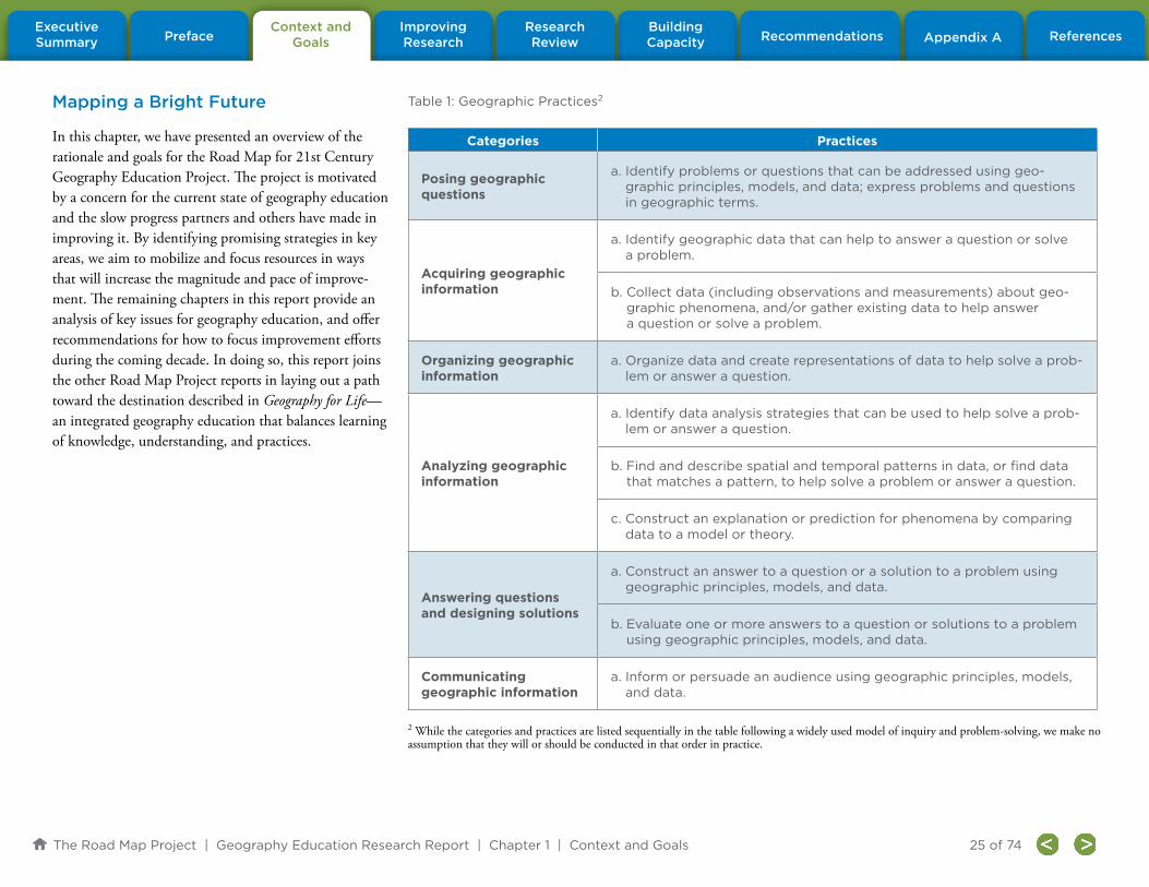
The Road Map Project | Geography Education Research Report | Chapter 1 | Context and Goals
PrefaceContext and
GoalsBuilding Capacity
Research Review Appendix A References
Improving Research Recommendations
Executive Summary
25 of 74
Mapping a Bright Future
In this chapter, we have presented an overview of the rationale and goals for the Road Map for 21st Century Geography Education Project. The project is motivated by a concern for the current state of geography education and the slow progress partners and others have made in improving it. By identifying promising strategies in key areas, we aim to mobilize and focus resources in ways that will increase the magnitude and pace of improve-ment. The remaining chapters in this report provide an analysis of key issues for geography education, and offer recommendations for how to focus improvement efforts during the coming decade. In doing so, this report joins the other Road Map Project reports in laying out a path toward the destination described in Geography for Life—an integrated geography education that balances learning of knowledge, understanding, and practices.
2 While the categories and practices are listed sequentially in the table following a widely used model of inquiry and problem-solving, we make no assumption that they will or should be conducted in that order in practice.
Table 1: Geographic Practices2
Categories Practices
Posing geographic questions
a. Identify problems or questions that can be addressed using geo-graphic principles, models, and data; express problems and questions in geographic terms.
Acquiring geographic information
a. Identify geographic data that can help to answer a question or solve a problem.
b. Collect data (including observations and measurements) about geo-graphic phenomena, and/or gather existing data to help answer a question or solve a problem.
Organizing geographic information
a. Organize data and create representations of data to help solve a prob-lem or answer a question.
Analyzing geographic information
a. Identify data analysis strategies that can be used to help solve a prob-lem or answer a question.
b. Find and describe spatial and temporal patterns in data, or find data that matches a pattern, to help solve a problem or answer a question.
c. Construct an explanation or prediction for phenomena by comparing data to a model or theory.
Answering questions and designing solutions
a. Construct an answer to a question or a solution to a problem using geographic principles, models, and data.
b. Evaluate one or more answers to a question or solutions to a problem using geographic principles, models, and data.
Communicating geographic information
a. Inform or persuade an audience using geographic principles, models, and data.

The Road Map Project | Geography Education Research Report | Chapter 2 | Improving Research in Geography Education
PrefaceContext and
GoalsBuilding Capacity
Research Review Appendix A References
Improving Research Recommendations
Executive Summary
26 of 74
Chapter 2: Improving Research in Geography Education
Chapter 1 provided the context and purposes of the Road Map Project, defined the project focus on the practices of geography, and pointed to the key role of Geography for Life: National Geography Standards, Second Edition as the project “destination” (Heffron & Downs, 2012). It also highlighted the value, power, and advan-tage of the key perspectives of geography. This chapter addresses the first charge of the Geography Education Research Committee: What areas of research will be most effective in improving geography education at a large scale? We outline two strategies: (1) careful consid-eration of education research in related fields, including science education; and (2) creation of a geography edu-cation research agenda based on the practices of geog-raphy outlined in Chapter 1 and organized around four key research questions. In the next chapter, we examine the existing research related to this proposed research agenda. Chapter 5 makes recommendations about how to operationalize ideas presented in this chapter.
Research in Education as a Model for Geography Education
This section reviews current trends in education research that geography educators can use to build synergies, capacity, and linkages with a vibrant research domain. Research in the past two decades has been especially rich in three areas: how people learn, how they learn in the context of particular disciplines, and how to translate these research findings into curricular standards and guidelines for instructional materials and for improving classroom practice.
Significant changes have occurred in how we think about and conceptualize learning in general and within specific domains. How People Learn: Brain, Mind, Experience, and School (National Research Council, 2000) provided a broad overview of what is known about learning by synthesizing research from cogni-tive, social, educational, developmental psychology, the learning sciences, neuroscience, and education. It presented three key findings: (1) preconceptions learn-ers bring to the classroom must be engaged to generate new and accurate learning, (2) competence in a subject requires a foundation of factual knowledge organized in a conceptual framework, and (3) metacognition plays a key role in learning through self-regulation. These three findings, and their implications for teaching presented in the volume, have played a significant role in shaping education and education research.
Several subsequent studies have examined learning in specific disciplines: Adding It Up: Helping Children Learn Mathematics (NRC, 2001a); How Students Learn: History, Mathematics and Science in the Classroom (NRC, 2005); Taking Science to School: Learning and Teaching Science in Grades K–8 (NRC, 2007); Learning Science in Informal Settings (NRC, 2009); and Learning Science through Computer Games and Simulations (NRC, 2011). Other studies have focused on learning that affects a range of disciplines, for example Learning to Think Spatially (NRC, 2006) described a type of thinking important in many contexts ranging from architecture to engineering to geography.
Some recent research, particularly in science education, has focused on developing domain-specific knowledge through participation in practices by concentrating on the epistemic, cognitive, social, and cultural factors that influ-ence the growth of knowledge. This research recognizes the parallels between subject-specific learning (viewed generally as the growth of knowledge) and inquiry (viewed as building new knowledge and refining existing knowledge). This approach emanates from a synthesis of ideas about the growth of knowledge and the nature of reasoning—ideas proposed by both the learning sciences and science education communities. Based on better knowledge about how children’s thinking is fundamental-ly different from adults’ and with richer understandings of expertise, representation, reflection, problem solving, and thinking, researchers in the learning sciences argue that “…students learn deeper knowledge when they en-gage in activities that are similar to the everyday activities of professionals who work in a discipline” (Sawyer, 2006, p. 4). Thus, students gain understanding from engag-ing in the practices of an academic domain. This argu-ment is supported by research on cognitive development and reasoning that demonstrates context matters; that content, learning environment, and learning goals are all important (Atran, 2002; Koslowski & Thompson, 2002; Siegal, 2002). That is, in both formal and informal con-texts, learning is linked to the domain within which the learning is taking place and depends on the acquisition of accepted representation and communication practices.
Not all education researchers agree that content knowl-edge is inherently domain-specific and must be learned

The Road Map Project | Geography Education Research Report | Chapter 2 | Improving Research in Geography Education
PrefaceContext and
GoalsBuilding Capacity
Research Review Appendix A References
Improving Research Recommendations
Executive Summary
27 of 74
in context. For example, Strand-Cary and Klahr (2008) have shown that it is possible for children to learn to design experiments, and that this strategy (the control of variables strategy) transfers to problems in different domains. In science education, research continues about whether, and how, more domain general principles can be used and applied, particularly at the earlier stages of learning. There is some evidence that certain processes are more domain-general and some more domain-spe-cific (Chi & Van Lehn, 2007).
Nonetheless, most research argues that the growth of knowledge involves both epistemic and social practices: building and refining theories and models; constructing arguments; and using specialized ways of talking, writ-ing, and representing phenomena (NRC, 2007). Taking Science to School (NRC, 2007), for example, advocates organizing learning around select conceptual knowledge frameworks and practices that, in turn, are coordinated around core ideas and learning progressions, also known as learning trajectories (Sztajn, Confrey, Wilson, & Edgington, 2012). A learning progression is defined as, “descriptions of the successively more sophisticated ways of thinking about a topic that can follow one another as children learn about and investigate a topic over a broad span of time” (NRC, 2007, p. 219).
This conceptualization of learning as both acquiring a body of knowledge and the “evidence–based, model building enterprise that continually extends, refines, and revises knowledge” (NRC, 2007, p. 2) is the culmina-tion of a decade of research examining the foundational basis for, and measurement of, disciplinary learning and is spelled out in A Framework for K–12 Science Education: Practices, Crosscutting Concepts, Core Ideas
(NRC, 2012). The framework put forth in the book or-ganizes the content of science around three dimensions: (1) practices (the cognitive, investigative and social factors involved with “doing” science); (2) crosscut-ting concepts (ideas that have wide application across a variety of subfields); and (3) core ideas. The framework emphasizes learning with core ideas and using appro-priate content-based practices, while considering the thematic features of the discipline represented by the crosscutting concepts. The framework focuses on what students must do to develop understanding of particular core ideas. In the past, the notion of doing science has been associated with the manipulation of objects and materials to engage learners with hands-on activities sometimes in ways that are isolated from disciplinary content. However, the framework embraces a shift from teaching what to teaching about how and why. This ap-proach aligns with contemporary conceptualizations of science—that science embodies the dialogic knowledge-building processes that are at the core of the discipline, namely obtaining and using principles, and evidence to develop explanations and predictions that represent the best reasoned beliefs about the world. It builds on the finding that classrooms should be knowledge-based (NRC, 2000)—specifically, what is taught (information and subject matter), why it is taught (understanding), and what constitutes competence or mastery, with an emphasis on doing with understanding.
We envision parallels, closer alignments, and linkages with these systematic approaches for geography educa-tion research, as well as an agenda that uncovers how to develop the growth of knowledge and proficiency in geography. We believe education research provides a model for this agenda. We must investigate:
1. The core ideas and skills that are potentially
domain-general and that may be needed in many
areas of geography, such as conceptions of scale,
pattern interpretation, systems, and the like.
Researchers should study whether it is possible to
teach relevant knowledge, skills, and practices in
ways that allow learners to apply what they have
learned when mastering new tasks or acquiring
new practices. Issues of transfer are especially
important here, including the transferability of
spatial thinking as well as ways to support the
integration of learning across subjects.
2. The core ideas and skills that are specific to
geography. Researchers should study what
concepts are unique or especially relevant and
appropriate to geography and how to best
develop them.
3. How to help learners build and refine informed
knowledge, perspectives, theories, and models of
geography.
4. How to support learners in thinking geographical-
ly; that is, understanding the systematic relation-
ships between and among people, places, and
environments. Additionally, we must learn how
to help learners construct arguments and think
critically through geography; that is, to engage,
“in a mode of discourse whose goal is to tease out
the relationship between ideas and the evidence”
(NRC, 2007, p. 33).
5. How to help learners to use accepted methods
to inquire about, describe, represent, and make
meaning of geographic phenomena; that is, to
engage in the practices of geography.
In addition, we see education research as tremendously relevant for geography education, especially with respect

The Road Map Project | Geography Education Research Report | Chapter 2 | Improving Research in Geography Education
PrefaceContext and
GoalsBuilding Capacity
Research Review Appendix A References
Improving Research Recommendations
Executive Summary
28 of 74
to the development and refinement of learning pro-gressions and mastery of the core ideas of geography. Geography education research should emulate the close relationships between the learning and cognitive sciences typically found in science education research. Further, to address the questions we identify below, it may well serve geography education research to adopt methods used by learning sciences researchers, such as design-based research (Cobb, Confrey, diSessa, Lehrer, & Schauble, 2003) for developing and testing curricu-lum materials and education programs intended to sup-port geography learning. A particularly productive area for geography education may be to emulate emerging research in mathematics learning trajectories that seeks to understand progressions of cognition and the instruc-tional strategies that use this understanding as a base to identify expected tendencies students are likely to follow as they develop understanding of concepts (Sztajn, Confrey, Wilson, & Edgington, 2012). In Chapter 4 we suggest lines of research that build on such link-ages. And finally, we propose concentrating research on geography’s core ideas and crosscutting themes to understand how to support students in learning the knowledge, skills, and practices of geography.
Crafting an Agenda in Geography Education
Although current education research provides a new way to conceptualize the research endeavor, it does not provide specific guidance for geography. In this section we develop a framework that proposes an agenda for geography education research. The framework consists of two parts: the practices of geography and four key research questions.
Practices of Geography
In Chapter 1 six practices of geography related to the skills and perspectives of Geography for Life were ex-plained. For planning and developing lines of research, however, the Committee thought the grain size of the six practices was too fine. Instead, from the six, three specific geographic practices essential to learning and thinking proficiently in geography were derived: (1) formulating geographic questions; (2) acquiring, organizing, and analyzing geographic information; and (3) explaining and communicating geographic patterns and processes. These practices are neither hierarchi-cal nor sequential and may be approached in multiple ways. They align with the six practices outlined in Chapter 1 (Table 1) but are broader and more compre-hensive to facilitate inquiry. Table 2 describes how each “research” practice is connected to the six Road Map Project practices.
Formulating geographic questions. To develop and ask appropriate geographic questions, one must iden-tify the geographic aspects of issues and problems and analyze them. This requires an understanding of the key ideas, concepts, principles, and perspectives of the disci-pline. Geographic questions invariably concern people, places, environments, and the connections among them. Not all issues have a geographic dimension but most do, and it is the ability to find the geographic aspects through applied knowledge and understanding that dif-ferentiates the geographic question from one asked by another discipline.
This practice corresponds to the Road Map Project practice, “pose geographic questions and problems” as shown in Table 2. The term formulate is significant because it connotes the ability to systematically under-stand and express relationships through the application of key geographic perspectives, models, and concepts.
Skills, Geography for Life Practices, Road Map ProjectPractices, Geography Education
Research Committee
Asking geographic questions Posing geographic questions Formulating geographic questions
Acquiring geographic information Acquiring geographic information
Acquiring, organizing, and analyzing geographic information
Organizing geographic information Organizing geographic information
Analyzing geographic information Analyzing geographic information
Answering geographic questions
Answering questions and designing solutions
Explaining and communicating geographic patterns and processes
Communicating geographic information
Table 2. The Practices of Geography: Geography for Life, Road Map Project Practices, and Geography
Education Research Committee Practices

The Road Map Project | Geography Education Research Report | Chapter 2 | Improving Research in Geography Education
PrefaceContext and
GoalsBuilding Capacity
Research Review Appendix A References
Improving Research Recommendations
Executive Summary
29 of 74
The focus on “where” and “why there” of geographic phenomena frames the way geography views the world and how geographic knowledge is constructed (Roberts, 2003). The focus also connects meaningfully to the fol-lowing practices of acquiring, organizing, and analyzing geographic information.
Many professions apply geography to address issues and problems. The ability—and disposition—to adopt a geographic perspective to solve problems is useful in a range of careers as well as in everyday life. The follow-ing chapter identifies a gap in the research literature concerning formulating geographic questions.
Acquiring, organizing, and analyzing geographic
information. A geographically proficient thinker answers geographic questions by using a range of tools and perspectives to acquire data, organize it (often times using maps and other spatial representations), observe, and seek meaning in the patterns of phenomena that occur in specific places, at a range of geographic and time scales. If done well, the outcome illustrates spatial and temporal patterns in the real world. This practice corresponds to the three Road Map Project practices “acquire geographic information,” “organize geographic information,” and “analyze geographic information.” This amalgam of practices includes locating and col-lecting data; observing and systematically recording information; reading and interpreting maps and other spatial representations; creating maps, graphs, and other visualizations; applying analytic strategies to find, describe, and interpret geographic patterns; and identi-fying the connections, associations, similarities, and dif-ferences in the geographic information. Often fieldwork is an essential component of this practice. Geographers understand the value of ground truthing (i.e., engaging
with the real world and collecting data in situ).
In conclusion, geographic data acquisition, organization, and analysis are practices common to many professions. Such skills have become increasingly important as the wealth of geographic data available through enhanced geospatial technologies has grown. However, little is known about how to develop learners’ proficiency to use geographic information.
Explaining and communicating geographic pat-
terns and processes. A key practice of geography is to explain —to construct, synthesize, and communicate geographic accounts at multiple and interlocking geo-graphic scales. These explanations can take the form of models or other visualization tools that can make sense of information and provide guidance for reasoned deci-sion making. Such explanations also may be rich and nuanced textual accounts or multimedia presentations. Whatever form they take, they are essential to com-municate complex issues in a democratic society. This practice corresponds to the Road Map Project practices “construct geographic answers and solutions” and “com-municate using geographic information.” The ability to offer a solution to a geographic problem, answer a geographic question, evaluate competing claims, or assess solutions to a problem using geographic concepts and models are all goals for geographic proficiency and important life and career skills. Chapter 3 provides a brief synthesis of research on this subject.
In summary, these three practices of geography correlate with those explained in Chapter 1, which are derived from the skills presented in Geography for Life. These skills form the core of the proposed research agenda—it is essential to know more about how individuals come to
learn and make meaning of the world in which they live through the knowledge, skills, and practices of geography.
Research Questions
To reach a more indepth understanding of how students learn these geographic practices, four education-related research questions are proposed, each providing an analysis of a different aspect of one or more of the prac-tices and suggestions for research. These questions are applicable to geography learners of all ages and educa-tional backgrounds, whether they are engaged through schools or informal communities (although the focus of the Road Map Project is learners K–12), including learners preparing to teach geography. The Committee believes the questions are comprehensive and inclusive yet offer clear targets for future research. As stated in the preface, geography education needs focused, concerted, systematic efforts to develop a richer research base.
This question considers three dimensions of learning: individual differences, settings, and time. Research about how individuals learn, how they learn at different times-cales (e.g., during a single session, a course, or a sequence of courses), and how they learn across significant life transitions (e.g., from school to work) is needed. Settings refer to organized activities that offer participants the opportunity to learn knowledge and skills. Some of these activities may have the express goal of promoting learn-ing (e.g., a school curriculum, a museum exhibit), but
Question 1:
How do geographic knowledge, skills, and
practices develop across individuals, settings,
and time?

The Road Map Project | Geography Education Research Report | Chapter 2 | Improving Research in Geography Education
PrefaceContext and
GoalsBuilding Capacity
Research Review Appendix A References
Improving Research Recommendations
Executive Summary
30 of 74
they may have other purposes as well. Learning in some activities may be incidental but nonetheless important for the development of proficiency. In addition, research concerning how individuals in a range of contexts and socioeconomic conditions develop the disposition to think geographically is important.
Research concerning this question should consider the knowledge and skills foundational to learning geography as well as the learning progressions in the subject. Additional research could focus on the application of geographic knowledge, skills, and practices to a purpose in a wide range of valued, consequential practices such as political decision making, land use planning, or deciding where to live.
As explained in the previous chapter, geography is a var-ied discipline encompassing both physical and social sci-ences as well as the humanities.3 Geography for Life reflects the broad nature of geography through its organization into six essential elements: The World in Spatial Terms, Places and Regions, Physical Systems, Human Systems, Environment and Society, and the Uses of Geography. The elements draw upon different intellectual traditions and vary in terms of their structure (ill-structured to structured following Spiro, Feltovich, Jacobson, & Coul-son, 1995), and therefore may demand different cognitive processes to learn.
The development of geographic knowledge, skills, and practices is affected by the element under study. Formu-lating a geographic question about a region’s economic activity, for example, requires different background knowledge and implies different approaches to problem solving than does a question about patterns of residential segregation within a city. Formulating a question that relates these two phenomena—as geographers might—requires yet other problem-solving approaches and understandings about how different kinds of systems and processes interact across different geographic and tem-poral scales. Research should illuminate the specific ways content shapes the skills, practices, and ways of thinking critical to the development of geographic proficiency in varied dimensions and applications.
Though young children may, through the course of ev-eryday activities, develop some forms of naïve geograph-ical thinking and reasoning, more sophisticated patterns of reasoning require external support. Curriculum, instructional materials, and teaching strategies, both in classrooms and in real-world settings such as through fieldwork, create the foundation for learning. Eliciting student thinking or orchestrating student discussion has proven important in addressing students’ misun-derstandings and developing their concept knowledge in other domains. Beyond the classroom, various adults may play the role of mentor and broker of opportuni-ties for field experiences. These adults also may provide
learners with access to powerful simulation and visual-ization tools.
Research about both formal and informal teaching should be designed to develop, test, and compare the efficacy of different strategies for developing proficiency in geographic thinking. Like those working in other fields, geography educators must understand how learn-ers acquire the core ideas of the discipline, what are the learning progressions in geography, and how to support and achieve them. It also is important that research focus on the development of learners’ engagement in, ability to reason with, and attitudes toward the applica-tion of geographic knowledge, skills, and practices in their daily lives.
To sustain new practices we must simultaneously intro-duce and sustain strategies to support their implemen-tation. This will require research concerning teacher preparation and professional development. Institution-alizing and supporting implementation of innovations in teacher preparation may require research about teacher knowledge and the beliefs that influence their approach to geographic learning (including their subject and pedagogical content knowledge). The Committee also sees a critical need for more research about profes-
3 This aspect of geography, while important and valued, is beyond the scope of the Road Map for 21st Century Geography Education Project.
Question 2:
How do geographic knowledge, skills, and prac-
tices develop across the different elements of
geography?
Question 3:
What supports or promotes the development of
geographic knowledge, skills, and practices?
Question 4:
What is necessary to support the effective and
broad implementation of the development of
geographic knowledge, skills, and practices?

The Road Map Project | Geography Education Research Report | Chapter 2 | Improving Research in Geography Education
PrefaceContext and
GoalsBuilding Capacity
Research Review Appendix A References
Improving Research Recommendations
Executive Summary
31 of 74
sional development, educational organizational systems, leadership practices, and the roles of intermediary organizations, such as Geographic Alliances, regarding teachers and their abilities to teach geography.
It is important that this research focuses on what en-sures effective implementation, that is, implementation that produces positive learning outcomes for young peo-
ple, and implementation that can occur at a large scale. Special attention should be paid to methods that will support adaptation and implementation in diverse cul-tural communities and among members of underrepre-sented groups. Finally, more research about the institu-tional forces and policies that shape the role and status of geography in the education system is required.
Summary
Together, the practices of geography and research questions proposed in this chapter provide an agenda and direction for geography education research. In the next chapter we outline the status of current research in geography education, with the goal of identifying gaps and suggesting priorities for such research.

The Road Map Project | Geography Education Research Report | Chapter 3 | Research Review
PrefaceContext and
GoalsBuilding Capacity
Research Review Appendix A References
Improving Research Recommendations
Executive Summary
32 of 74
Introduction
This chapter reviews the existing research literature in ge-ography education, focusing primarily on studies that are germane to the four key research questions introduced in Chapter 2:
1. How do geographic knowledge, skills, and practic-
es develop across individuals, settings, and time?
2. How do geographic knowledge, skills, and prac-
tices develop across the different elements of
geography?
3. What supports or promotes the development of
geographic knowledge, skills, and practices?
4. What is necessary to support the effective and
broad implementation of the development of geo-
graphic knowledge, skills, and practices?
This review aims to address the first charge of the Geography Education Research Committee: to identify the research that will be most effective in improving ge-ography education at a large scale and fill existing gaps in the literature. Success will be achieved when we can draw upon an empirical research foundation deep and rich enough to provide satisfactory answers to the four key re-search questions. The first step in this process will require a firm understanding of what we already know and what remains to be known to supply the geography education community with confident answers. Closing the research gap is the focus of the research agenda presented in this report. It also represents the principal challenge facing researchers acting upon our recommendations.
This chapter begins by summarizing the status of geography education research by reviewing reports assess-ing such research produced in the past 20 years. Next, we identify the existing body of research that has focused on each of the four key research questions (problems), and we highlight, when possible, any important aspect or dimension of the study that has dealt explicitly with the geographic practices of formulating geographic questions; acquiring, organizing, and analyzing geo-graphic information; and explaining and communicating geographic patterns and processes. After summarizing the characteristics of that research, we assess the extent to which it has contributed to our understanding of relevant issues stemming from the problem. Finally, we identify gaps in research that require further investigation. The conclusions of this review inform the next two chapters: Chapter 4, which offers strategies for building research capacity in geography education; and Chapter 5, which offers a series of recommendations for implementing our vision of a geography education research agenda.
Status and Characteristics of Research in Geography Education
During the past 20 years a number of reports have assessed the state of research in geography education (Table 3). These articles provide taxonomies of research topics, descriptions of research methodologies, and a broad overview of the knowledge produced by the research. In general, they share the following arguments and conclusions:
• Geography education should develop its own
learning theories while drawing on relevant theo-
ries of teaching, learning, and assessment from
cognate fields.
• The nature of questions asked by geography
education researchers must be expanded and
collaborative research should be conducted when
appropriate.
• Research in developmental psychology and cog-
nitive science offers the most relevant findings
for geography education research.
• Research methodologies must consider student
demographics more carefully.
• Curricular decisions about the learning progres-
sion of geography topics and skills should be
made on the basis of empirical data.
To summarize, these evaluations of geography education research paint a portrait of a field that is generally:
• parochial,
• inward-looking,
• disconnected from educational research in
other disciplines,
• small scale (i.e., small number of study
participants),
• asynchronous (i.e., few longitudinal studies), and
• descriptive and anecdotal, limited in quantity
(but not in quality).
Chapter 3: Review of Geography Education Research

The Road Map Project | Geography Education Research Report | Chapter 3 | Research Review
PrefaceContext and
GoalsBuilding Capacity
Research Review Appendix A References
Improving Research Recommendations
Executive Summary
33 of 74
The reports also find that prior studies:
• rarely feature a controlled experimental
design, and
• lack replication studies and interdisciplinary
approaches (Bednarz, Downs, & Vender, 2003;
Butt, 2010; Lambert, 2010).
Compared with educational research in mathematics and science, discipline-specific findings are few and consen-sus is lacking. In short, geography education research is a fragile field with few practitioners, little funding, and weak institutional support.
A variety of factors have contributed to the state of geography education research. Geography education has a history of being driven by advocacy and activities to make geography more visible, rather than being characterized by people doing and reporting research (Bednarz, 2000; Bednarz, 2004; Stoltman, 1997). Within social studies journals, geography education articles are underrepre-sented compared with articles concerning history, political science, or economics education (Segall & Helfenbein, 2008). This has led to calls for more research (Ball, 1968; Baker & Bednarz, 2003; Bednarz, 2000; Castner, 1997; Downs, 1994b; Stoltman, 1997). It is clear that geogra-phy education initiatives should be grounded in research, but a question concerning implementation remains: How should geography education move forward to develop coherent learning theories while simultaneously contrib-uting to practical education issues?
The Committee believes that the impact of geography education research will grow if it employs the same stan-dards for rigor used in other domains of educational re-search. Our strategy is to link the future research agenda
Title Editor(s)/Author(s) Year Published
The National Council for Geographic Education: The First Seventy-five Years and Beyond
J. W. Vining 1990
Research on Geography Teaching
(in Handbook of Research on Social Studies Teaching and Learning)
J. P. Stoltman 1991
A Decade of Reform in Geographic Education: Inventory and Prospect
R. S. Bednarz, J. F. Petersen 1994
Learning Geography: An Annotated Bibliography of Research Paths
A. S. Forsyth, Jr. 1995
Understanding Geographical and Environmental Education
M. Williams 1996
The First Assessment: Research in Geographic Education
R. G. Boehm, J. F. Petersen 1997
Rediscovering Geography: New Relevance for Science and Society
National Research Council
(Rediscovering Geography Committee)
1997
Geography Education
(in Geography in America at the Dawn of the 21st Century)
S. W. Bednarz, R. M. Downs, J. C. Vender
2003
Toward Building a Research Agenda for Geographic
Education (special issue of Research in Geographic Education)S. Walker 2005
Research on K–12 Geography Education
(in Handbook of Research in Social Studies Education)A. Segall, R. J. Helfenbein 2008
Perspectives on Research in Geography Education
(special issue of International Research in Geographical and Environmental Education)
G. Butt 2010
Table 3. Reports Evaluating Research in Geography Education, 1990 to 2010

The Road Map Project | Geography Education Research Report | Chapter 3 | Research Review
PrefaceContext and
GoalsBuilding Capacity
Research Review Appendix A References
Improving Research Recommendations
Executive Summary
34 of 74
in geography education with precedents established in other fields (see Chapter 2). In developing this strategy, the Committee considered the core assessments of prior geography education research in relation to standards of effective practice based on the National Research Council’s publication Scientific Research in Education (2002). Based on these criteria, future research studies in geography education should:
1. pose significant questions that can be investi-
gated empirically;
2. link research to relevant theory;
3. use the most appropriate and effective methods
that permit direct investigation of the research
question(s);
4. provide a coherent and explicit chain of reason-
ing, linking evidence to theory, and describe
procedures in a sufficiently detailed fashion to
enable replication;
5. be replicable and generalizable in a range of set-
tings and populations; and
6. embrace ideals of scholarly behavior through wide
dissemination, peer review, and public scrutiny.
Research results from studies with experimental and quasi-experimental designs build a foundation for future research. Geography education research should shape inquiry, open areas for further investigation, and sug-gest hypotheses worthy of testing and those that are not (Williams, 1996). Unfortunately, geography education research has long been undervalued (Downs, 1994a), resulting in a paucity of empirical research and longitudi-nal studies. Given the scarcity of research, it is impossible to build on common models or topics (Stoltman, 1997). Unlike other geography subfields, few researchers at the
university level work in geography education until later in their career. Because of the relatively few scholars engaged in geography education research, progress in geography education has been modest. Until research is valued and conducted rigorously, geography education reform efforts are likely to achieve little success (Downs, 1994a).
At least three issues could be addressed by the findings of research in geography education. First, high-quality instruction is founded on high-quality research that guides educational decisions (Downs, 1994b; Forsyth, 1995). Research should explicitly inform and connect to the practice of teaching because teachers or instructors, especially those without a strong geography education background, cannot be expected to make those con-nections themselves (Downs, 1994b). Second, research should provide guidance to outreach projects such as writing standards, creating teaching materials (Fox, 1997), formulating frameworks to plan geography programs for map learning (Catling, 1996), and creating assessments (Daugherty, 1996). The current literature does not inform “what,” “how,” and “when” to teach geography. Research that guides standards, curricula, and policy decisions and that reflects the current reality of geographic theory and practice is necessary (Kaufman, 2004). In other words, standards and recommendations should be based on evidence from research rather than on experience, anecdotes, and the enthusiasm of writers (Downs, 1994b). Third, data are needed to converse with certainty and credibility, about topics such as stu-dent performance and the effect of standards on student learning (Williams, 1996).
Geography education research has the potential to ad-dress many issues, ranging from teaching and learning
about maps and developing spatial abilities to learning about models of curriculum design and programs of in-struction (Bednarz, Downs, & Vender, 2003). Research is published in journals such as International Research in Geographical and Environmental Education, Journal of Geography, Journal of Geography in Higher Education, and Research in Geographic Education. Stoltman (1997) reports that curricular articles published between 1902 and 1969 in the Journal of Geography made the transi-tion from a focus on memorization to the application of geographic tools and techniques. Brown (1997) and Bednarz (2000) argue that although these articles are concerned with instructional strategies and methods, they are descriptive and applied. Where empirical re-search methods are applied (Segall & Helfenbein, 2008), authors pay little attention to many conventions of scientific education research (e.g., reliability, generaliabil-ity, random assignment of students, etc.) and make little connection with existing or past geography education research, which limits the usefulness of the research for developing cumulative knowledge (Bednarz, 2000).
Since the mid-1990s, articles concerning the processes of learning and thinking in geography have begun to appear in the literature. These studies apply educational and learning theory to geography by employing empiri-cal approaches to address research questions (Bednarz, 2000), but articles that evaluate the soundness of methodologies, methods of data collection, and limita-tions of the research are rarely found in the literature (Williams, 1996). In the English-language geography education journals listed above, articles with a teach-ing focus exceed those about learning and thinking. Criticisms of geography education research include its

The Road Map Project | Geography Education Research Report | Chapter 3 | Research Review
PrefaceContext and
GoalsBuilding Capacity
Research Review Appendix A References
Improving Research Recommendations
Executive Summary
35 of 74
lack of rigor, inability to build coherent theories, and its failure to link theory with practice (Gregg & Leinhardt, 1994; Segall & Helfenbein, 2008). Rarely do these studies generalize beyond a single classroom experience
(Downs, 1994b; Gerber, 1996; Lambert, 2010). It should be noted that some of these issues are prevalent in education research in other fields (see NRC, 2002, for a summary of factors that influence education
research); for example, real and perceived disconnects between educational research, theory, and practice (Broekkamp & van Hout-Wolters, 2007; Grossman & McDonald, 2008).
Research on Key Research Questions for Geography Education
The preceding discussion, which focused on the general characteristics of the geography education research landscape, provides a foundation for the recommenda-tions about how research should be conducted in the future (see Chapter 5).
In this section, we synthesize research that is most closely related to the four key research questions. For each question, we briefly summarize the state of knowledge and then outline what we still do not know. Recommendations for future research are made on the basis of these assessments.
Geography is an interdisciplinary subject that borrows and builds on theories from cognate fields. The follow-ing synthesis illuminates the education-research connec-tions that exist among cognitive psychology, geography, geosciences, and social studies.
Question 1
How do geographic knowledge, skills, and practices devel-op across individuals, settings, and time?
Question 2
How do geographic knowledge, skills, and practices develop across the different elements of geography?
Question 3
What supports or promotes the development of geographic knowledge, skills, and practices?
Question 4
What is necessary to support the effective and broad imple-mentation of the development of geographic knowledge, skills, and practices?
IN THIS SECTION, YOU WILL FIND A REVIEW OF LITERATURE ADDRESSING:

The Road Map Project | Geography Education Research Report | Chapter 3 | Research Review
PrefaceContext and
GoalsBuilding Capacity
Research Review Appendix A References
Improving Research Recommendations
Executive Summary
36 of 74
This question considers three dimensions of learning: individual differences, settings, and time. Individual differences include student characteristics such as socio-economic status, ethnicity, and sex. Of these, geography education studies have most frequently focused on sex-related differences. The term “sex-related” is used to refer to correlation(s) observed between gender (female or male) with a measured variable (e.g., Montello, Lovelace, Golledge, & Self, 1999). Research about how individu-als learn, about the importance of place in settings of organized activities, and about how students learn at different timescales, is reviewed in the following sections.
Individual Differences
What is known:
Student performance in geography is affected by family income, ethnicity, and gender. The National Assessment of Educational Progress (NAEP) reports that students from lower-income families (determined by eligibility for National School Lunch Program) score lower than other students in grades 4 and 8 (family income was not measured for grade 12 students). NAEP results also indicate that white students perform best. Performance gaps between white, black, and Hispanic students diminish from elementary to middle school (National Center for Education Statistics, 2011).
In the past three NAEP geography assessments (1994, 2001, and 2010) males performed better than did females at all three grade levels (NCES, 2011). On a
similar national exam, Advanced Placement Human Geography (APHG), males scored higher on multiple choice questions than did females, although females scored higher on essay responses (Monk, 2011). This trend seems to be repeated at the university level with freshmen males performing better than females on map skills and geography knowledge (Bein, Hayes, & Jones, 2009; Henrie, Aron, Nelson, & Poole, 1997). Other studies find only insignificant sex differences or find initial differences that disappear with education (e.g., LeVasseur, 1999). Sex differences in student perfor-mance have also been documented in other countries. For example, females perform better than males in teach-er-assessed and external assessments at the middle and secondary levels in the United Kingdom (Butt, 2001; Butt, Weeden, & Wood, 2004; Wood, 2002). Evidence suggests that the form of assessment affects performance. For example, females perform better on written assign-ments that are completed over multiple lessons (Butt, 2001; Butt, Weeden, & Wood, 2004).
Sex-related differences also exist with respect to spatial skills. Research in psychology and geography has found that spatial skills vary with sex (Hedges & Nowell, 1995; Linn & Petersen, 1985; Voyer, Voyer, & Bryden, 1995) and that differences in performance level change with age (Gilmartin & Patton, 1984; Linn & Petersen, 1985). Whereas males perform bet-ter on some tasks such as mental rotation and way-finding (Linn & Petersen, 1985; Montello, Lovelace, Golledge, & Self, 1999; Sorby, 2009), females do well
on others such as spatial relational tasks and loca-tion recall (Honda & Nihei, 2009; Keith, Reynolds, Roberts, Winter, & Austin, 2011). These differences, however, may not affect performance of complex spatial tasks (Bunch & Lloyd, 2002). Cognitive psy-chologists have found that both females and males can improve their performance on some types of spatial thinking tests (Uttal et al., In press). However, the links between these types of spatial thinking skills and the geography knowledge, skills, and practices de-scribed in this report have yet to be determined. Albeit small, female-male differences in spatial skills predict for success on the National Geographic Bee qualifying test (Liben, 2002). The working hypothesis linking spatial skills to mastering geography knowledge is that “better spatial skills ease map navigation, in turn increasing the appeal of maps in general, thereby moti-vating examination of atlases, in turn enhancing both factual and conceptual geographic knowledge” (Liben, 2002, p. 5).
Future research needs:
Monk (2011) argues that the role of gender in curricula, pedagogy, and student participation in geography educa-tion, especially at the K–12 level, is under researched. Studies have yet to untangle factors that explain how sex-related academic differences occur, for example, the influence of student characteristics (e.g., masculinity, sex) and scholastic disposition (e.g., ability, attitude, life experience, whether one chooses to major in geography,
How do geographic knowledge, skills, and practices develop across individuals, settings, and time?1
The Road Map Project | Geography Education Research Report | Chapter 3 | Research Review
PrefaceContext and
GoalsBuilding Capacity
Research Review Appendix A References
Improving Research Recommendations
Executive Summary
37 of 74
etc.) (Butt, Weeden, & Wood, 2004; Hardwick, Bean, Alexander, & Shelley, 2000). More evidence also is need-ed to understand how assessment methods and structures influence patterns of student performance (Butt, 2001) to address questions regarding equality of opportunity when evaluating students as well as assessment effects on students’ attainment, motivation, and self-esteem both in school and beyond. Because sex predicts performance (Liben, 2002), future research should include it as a vari-able to disaggregate performance data (Hill, Corbett, & St. Rose, 2010). Inclusion of other factors (e.g., socioeco-nomic status, race, language, culture, and other demo-graphic differences) is encouraged to assess learning across diverse demographic groups.
Studies on Formal vs. Informal Settings
What is known:
Most geography education research has focused on for-mal classroom settings at the high school and undergrad-uate levels. Some geography education research provides evidence that students’ understanding and perceptions of space (e.g., neighborhood or landscapes) are influenced by daily experience or exploration of the natural and cultural environments (Catling, Greenwood, Martin & Owens, 2010; Gillespie, 2010; Klonari, Dalaka, & Petanidou, 2011). This work is parallel to education research about informal learning that reveals the impor-tance of participation structures and the development of practices in culturally valued activities (Cole, 1996; NRC, 2009). Thus, informal learning researchers provide “broader units of analysis…these views move beyond the study of individuals alone to consider how learning occurs within enduring social groups such as families and
communities” (Bransford et al., 2006, p. 24).
Personal experiences, such as travel and use of maps, influence students’ map interpretation achievement (Rapp, Culpepper, Kirkby, & Morin, 2007) as well as geographic problem-solving performance (Wigglesworth, 2003), and such experiences have a positive impact on one’s affinity for geography as an adult (Catling, Greenwood, Martin, & Owens, 2010). Research also indicates that young people may develop geographic understandings and skills incidentally, over the course of many years (Battersby, Golledge, & Marsh, 2006).
Fieldwork is a combination of structured learning in an informal environment. Traditionally, it has been an important component of geography education, and its positive impact on learning has been documented (Boyle et al., 2007; Fuller, Edmondson, France, Higgitt, & Ratinen, 2006), particularly in learning about physi-cal systems through the collection and analysis of data (Hoalst-Pullen & Gatrell, 2011; Resler & Kolivras, 2009; Rydant, Shiplee, Smith, & Middlekauff, 2010). Fieldwork abroad also has been shown to be beneficial. Students who directly observe and experience foreign communities gain cultural understanding and human geography knowledge (Hope, 2009; Steen, 2009). Fieldwork also serves as a valuable mode of learning to evaluate theories (e.g., Central Place Theory) (Theo, 2011). Finally, student enjoyment of geography, which is linked to deeper learning (Boyle et al., 2007), is positive-ly affected by fieldwork (Kern & Carpenter, 1984).
Some environments support the learning of transfer-able skills. More specifically, through fieldwork and problem-based learning, students gain problem-solving
and teamwork skills (e.g., Andrews, Kneale, Sognez, Stewart, & Stott., 2003; Spronken-Smith, 2005), while collaborative learning settings have been shown to impart transferable skills that are useful in occupational, social, cultural, and political activities (e.g., Healey, 1992; Hindle, 1993).
Future research needs:
Studying how different contexts promote learning can help develop a better understanding of how the set-ting, formal or informal, affects geography teaching and learning. Research about how experience with informal geography translates to learning geography is becoming more important as time in the school curriculum for ge-ography declines while the focus on science, technology, engineering, and mathematics (STEM) and high-stakes testing increases. Informal settings are interesting sites for research because they must work to maintain student engagement or risk losing youth participation. As such, popular informal programs (e.g., 4-H GIS) provide valuable examples to emulate. Fruitful areas of research might investigate how geospatial technology supports geographic learning at a museum (e.g., Bloodworth & Petersen, 2011), as part of service-learning activities (Bednarz et al., 2008) or as part of a community activity (e.g., Elfin & Sheaffer, 2006; Powell, Smith, & Black, 2009; Taylor, 2009). An examination at a large scale of the inter-connectedness between these learning environ-ments also is needed (Lash & Wridt, 2002).
To understand learning in informal environments bet-ter, it is important to comprehend how teachers’ access to and use of young people’s everyday (informal) geog-raphy knowledge affects their disciplinary and school (formal) knowledge (Wridt, 1999).

The Road Map Project | Geography Education Research Report | Chapter 3 | Research Review
PrefaceContext and
GoalsBuilding Capacity
Research Review Appendix A References
Improving Research Recommendations
Executive Summary
38 of 74
More research on how fieldwork relates to student learning is needed (Fuller, Edmondson, France, Higgitt, & Ratinen, 2006). Although fieldwork is valued by teachers, most trips are excursions rather than active-learning activities based on geographical inquiry or discovery (Chew, 2008; Munday, 2008). Various con-straints, often beyond the control of the teacher (e.g., time, cost, student safety), reduce the opportunities for fieldwork (Han & Foskett, 2007; Munday, 2008). Future research should examine what conditions result in a sustainable, positive field experience that produces demonstrable inquiry and learning. Questions that could initiate a research study include: At what age can students conduct meaningful fieldwork? What type of fieldwork engages students? Studies also should examine the impact of fieldwork (real and virtual) on learning geography concepts and skills. Current research on transferable skills is primarily found in higher educa-tion and relates to career readiness (e.g., Adams, 2013; Solem, Cheung, & Schlemper, 2008), while research at the K–12 level has been silent on this topic.
Time-Related Studies
What is known:
Time-related research is divided into two categories: (1) how students learn across their life-spans and through significant life transitions (e.g., from school to work), and (2) how individuals learn at different timescales (e.g., during a single session, a course, or a sequence of courses).
Life-span learning. Life-span learning research has focused, for the most part, on map understanding. Studies tying geography learning to life transitions such
as applying geography knowledge to reading a news-paper (e.g., Gregg, Staintoon, & Leinhardt, 1998) or understanding about geography careers (e.g., LeVasseur, 1999) are rare, and their sample sizes are insufficient to draw conclusions. Research concerning when it is feasible, possible, or optimal to learn specific geography concepts is based largely on the map-use and interpreta-tion literature.
Within the field of geography, and more generally in cognitive science, there has been an interesting debate concerning how young children develop spatial knowl-edge, particularly in their ability to use maps. Two schools of thought contribute to the discussion: nativism and constructivism (Newcombe & Huttenlocher, 2000). The nativist model argues that map learning and interpretation are innate in young children and thus require little guidance (Blaut, 1991; Blaut, McCleary, & Blaut, 1970; Blaut & Stea, 1971; Landau, 1986; Stea & Blaut, 1973). The constructivist learning model sug-gests that map understanding begins at an early age, but mastery develops later in life (Liben & Downs, 1997). The developmental sequence is gradual, multifaceted, and complex (Liben & Downs, 1989; Liben & Downs, 1997), constructed from a combination of experience and formal instruction grounded in cartographic and cognitive developmental theories (Downs & Liben, 1988). Research that supports progressive learning also is found in work about the interpretation of aerial images (e.g., Kirman, 1981; Kirman & Jackson, 1993) and comparisons of children’s and adults’ map drawing abil-ity (e.g., Kirman & Goldberg, 1992).
Time-scale learning. Students need time to learn and improve their geographic knowledge, skills, and practices.
Geography-specific knowledge such as nomenclature (Salsbury, 2006), map knowledge recall (Zirkle & Ellis, 2010), and geographic concepts (Coban, Akpinar, Kucukcankurtaran, Yildiz, & Ergin, 2011; Turner & Leydon, 2012), requires one to four weeks of instruction. Even when students are given repeated instruction over several weeks, individual differences in performance exist. Some students understand the concepts quickly while others experience more difficulty (Ishikawa, 2002). In other instances, despite the allocation of sufficient time and application of appropriate instruction, some students retain misconceptions such as the notion that closely spaced contour lines represent high elevation (Clark et al., 2008). However, some studies suggest that gained knowledge is durable over time (e.g., Turner & Leydon, 2012; Zirkle & Ellis, 2010).
For problem-solving exercises, positive learning outcomes depend on allowing sufficient time for students to move through the inquiry process. Even if they are unable to formulate a viable research question, they need time to identify relevant data sources, collect the data, and analyze the data to formulate a conclusion (e.g., Yeung, 2010). In classes where teachers presented students with multiple connected problems over the course of a semes-ter or year, students began to understand how to compose geographic questions and conduct geographic analyses (Gautier & Solomon, 2005; Kulo & Bodzin, 2011).
Future research needs:
Geography education research is commonly conducted over a single lesson. Few longitudinal studies that might lead to an understanding of changes in student knowledge, skills, and practices over time exist. Future research should include studies that ask students to work

The Road Map Project | Geography Education Research Report | Chapter 3 | Research Review
PrefaceContext and
GoalsBuilding Capacity
Research Review Appendix A References
Improving Research Recommendations
Executive Summary
39 of 74
on multiple problems over the course of a semester or year so that they develop relatively sophisticated un-derstandings about formulating geographic questions and conducting geographic analyses (e.g., Kwan & So, 2008). From studying student cohort(s) in a longitudi-nal fashion, researchers can determine what sequences of instruction produce more effective learning of geograph-ic and crosscutting concepts (e.g., scale and complex
adaptive systems). Studies of APHG classes offer op-portunities for understanding how such courses prepare students for undergraduate study in geography and other fields (Gray, Hidlebrant, & Strauss, 2006; Stoltman, Blouet, Hollier, Standish, & Conrad, 2005). Also of interest are how students learn over their life-spans, and whether and how their misconceptions change. Some research suggests that even with instruction,
misconceptions are difficult to change (Clark et al., 2008). We suggest life-span research should include studies to inform what type of instruction is appropri-ate at what ages, and such research should examine how geographic learning is affected by life contexts (e.g., friendship patterns), events (e.g., migration), and transi-tions (e.g., puberty) (Downs, 1994c).

The Road Map Project | Geography Education Research Report | Chapter 3 | Research Review
PrefaceContext and
GoalsBuilding Capacity
Research Review Appendix A References
Improving Research Recommendations
Executive Summary
40 of 74
This section divides the discipline of geography into human geography and physical geography, but some themes, such as map learning, figure into both areas. As such, map learning is discussed first followed by a discussion of teaching geography in an interdisci-plinary setting.
Mapping Across Human and Physical Geography
What is known:
Mapping is an important element of both human and physical geography. For example, NAEP integrates maps into both physical and human geography questions. We know that children by the age of three develop a concept of what constitutes a map, and with age, they widen their definition (Downs & Liben, 1988). The 2010 NAEP test suggests that a majority of elemen-tary students can use a map to perform basic tasks, such as identification of major geographic features, and that they have the ability to read and draw simple maps (NCES, 2011). However, studies also report that students have misunderstandings about representation and geometric relationships (Liben & Downs, 1989). Many elementary students have difficulty understand-ing scale, size relationships, and symbolic representation (e.g., Kastens & Liben, 2007; Liben & Downs, 1989; Uttal, 1996). Performance improves with students’ cognitive development so that college students under-stand the relationship between the use of symbols on
a map and the objects they represent in the real world (Bunch, 2000; Kastens & Liben referenced in Ishikawa & Kastens, 2005), but it is a slow learning process (Liben & Downs, 1997). Students perform better when the symbols reflect real objects rather than abstract ones (DeLoache, Uttal, & Pierroutsakos, 1998). Student learning about map symbols also can be supported by explicit instruction, regardless of whether a didactic-analytic or activity-inquiry model is used. Regardless, students, especially those with little initial map knowl-edge, who made their own maps (activity-inquiry model), learned more about map reading and interpre-tation compared with students who did not make their own maps (Gregg, 1999).
Results from the 2010 NAEP test suggest students’ un-derstanding of, and ability to use, maps increases with their grade level. By grade 4, students can use latitude to locate an island; by grade 8, they can solve locational questions using latitude and longitude and interpret simple map scales; by grade 12 students are able to identify several basic map projections and interpret geographic data from more sophisticated representa-tions, such as cartograms (NCES, 2011). Research shows similar findings for mapping tasks such as route planning (e.g., Golledge, Marsh, & Battersby, 2008; Wigglesworth, 2003). It is evident that age and experi-ence lead to a higher level of problem-solving ability. An expert performs better than a novice (e.g., Anderson & Leinhardt, 2002). Difficulty in understanding
projections and coordinate systems is noted in high school and college students (Liben, 1978; Signorella & Jamison, 1978), and this difficulty is similar to the problems students experience with some Geographic Information System (GIS) operations (e.g., buffer, over-lay) (Battersby, Golledge, & Marsh, 2006).
Students can be taught strategies to improve their ability to analyze geographic variability. This process can begin in the elementary grades with support and opportunities to record and share observations (Shobe & Banis, 2010), followed by students categorizing and quantifying data for tables and graphs that facilitate interpretation (e.g., Doering & Veletsianos, 2007; Thomas, 1994). With teacher support and scaffolding, elementary school students can use the basic functions of a GIS (e.g., zoom, measure distance, query) to identify patterns (e.g., Keiper, 1999; Shin, 2007). At the high school level, studies have examined how students, by learning various ways to collect, display, and analyze spatial data, develop techniques to work with large datasets (both size and scale) (e.g., Koch & Denike, 2007). We also know that student identification of location on a map improves when they are asked to think about their rea-soning process (Kastens & Liben, 2007).
Future research needs:
Although research about children’s ability to interpret a map exists, much less work has been done regarding their ability to use a map for analysis. For example, what
How do geographic knowledge, skills, and practices develop across the different elements of geography?2

The Road Map Project | Geography Education Research Report | Chapter 3 | Research Review
PrefaceContext and
GoalsBuilding Capacity
Research Review Appendix A References
Improving Research Recommendations
Executive Summary
41 of 74
types of questions (declarative and researchable) do stu-dents generate using a map (e.g., Gregg, 1997) and what types of analytical strategies do they employ and how do these differ across student populations (e.g., Audet & Abegg, 1996; Huynh & Sharpe, 2009; Wigglesworth, 2003). Students must be taught these skills or they must acquire them in some other way. Future research might compare the map-analysis skills of novices and experts (Bunch, 2000) to discern how acquisition of content knowledge, analytical strategies, and other traits en-able novice students to become experts. How learners perform in various sizes of experimental space (e.g., desk top versus environmental size) also should be studied (Bell, 1999). Finally, the importance of learning progres-sions should be researched to determine the types of tasks that will help move students’ intermediate under-standings to a more sophisticated level.
Some researchers propose that spatial understanding follows a hierarchy of concepts, moving along a con-tinuum from primitive to complex (Golledge, Marsh, & Battersby, 2008; Marsh, Golledge, & Battersby, 2007). At present, sufficient research does not exist to evaluate the accuracy of the position of elements on this proposed continuum.
Physical Geography
What is known:
Some research points to student struggles with physi-cal geography concepts (e.g., climate and landforms) at the elementary and middle school levels (e.g., Hickey & Bein, 1996; LeVasseur, 1999), extending to students in higher education (Reinfried, 2006). For example, students hold misconceptions about Earth’s shape (e.g.,
rectangular, disc shaped) and Earth’s crust (e.g., Libarkin, Anderson, Dahl, Beilfuss, & Boone, 2005; Vosniadou & Brewer, 1992), and they also hold the misconception that north is always at the top of the page (e.g., Liben & Downs, 1997). One means to enhance students’ understanding of physical geography concepts is through the use of models or graphics (Hickey & Bein, 1996; Reinfried, 2006).
Student understanding of physical geography also is supported by use and interpretation of maps, with em-phases on the ability to read topographic maps (Clark et al., 2008; McChesney & McSweeney, 2005; Pedersen, Farrell, & McPhee, 2005; Rapp, Culpepper, Kirkby, & Morin, 2007) and on the ability to understand models of Earth’s surface (Rapp, Culpepper, Kirkby, & Morin, 2007; Reinfried, 2006).
Future research needs:
Although the literature suggests some areas of diffi-culty for students, more research is needed to examine when and in what setting students develop geographic conceptions. Future research should study promising methods to help students understand problematic ideas. Subsequent investigations, as well as research within a culturally responsive learning framework, are needed to provide support for that approach (Smith, diSessa, & Roschelle, 1994). We also need to know more about how students develop preconceptions or misconceptions, an area that has been investigated fruitfully for other subjects. Finally, research is needed on how activities complementary to instruction and textbook reading (e.g., computer modeling) can support physical geogra-phy education.
Human Geography
What is known:
Young children’s understanding of space is based on their experiences. Elementary students’ understand-ing of places and regions is centered on individuals, families, and local settings with little evidence that they understand the larger space of nation or globe (Brophy & Alleman, 2005a). Thus, daily experiences and easily observable phenomena are foundations on which young children develop knowledge, but how children develop an understanding of cause-effect relationships is not as well known (Brophy & Alleman, 2005a). At the elemen-tary level, children have little awareness of the human-environment relationship such as people’s influence on the natural environment and changing patterns of flora and fauna (Brophy & Alleman, 2005b).
A significant body of research has used mental mapping to teach geography and to learn about student percep-tions of place. Although student perception of the world may be related to their place of residence and therefore biased (e.g., Californian students are more likely to place the Pacific Ocean in the center of their mental map) (Thomas & Willinsky, 1999), explicit instruction im-proves students’ accuracy (e.g., continent size, location) (Chiodo, 1997). Such research also has focused on how mental maps can be used to teach human geography. For example, Shobe & Banis (2010) produced choropleth maps showing the perceived distribution of music genres based on composite responses.
Other forms of documenting learning, such as concept mapping (Wehry, Monroe-Ossi, Cobb, & Fountain, 2012) or journal writing (Hooey & Bailey, 2005; Warkentin, 2011), are not commonly used by researchers.
The Road Map Project | Geography Education Research Report | Chapter 3 | Research Review
PrefaceContext and
GoalsBuilding Capacity
Research Review Appendix A References
Improving Research Recommendations
Executive Summary
42 of 74
Future research needs:
Human geography is diverse, making it difficult to generalize about what supports students’ acquisition of knowledge, skills, and practices. We can learn from edu-cation researchers who design standards- and content-based research that can be translated into practice. These studies include investigations about “how and how much students are able to achieve, about how teachers conduct and learn to conduct their practice, about how to assess what students understand and are able to do” (Collins, 1998, p. 725).
Interdisciplinary Learning
What is known:
Emerging research suggests that middle school students exhibit positive learning outcomes when geography is taught in conjunction with math or reading. The interdisciplinary programs, GeoMath and GeoLiteracy, produced significant gains in students’ performance in math (Dorn et al., 2005) and reading comprehension
(Hinde et al., 2007) while students’ understanding of geography also improved.
Future research needs:
Little research in geography education is interdisciplin-ary even though many research questions require an interdisciplinary perspective. Future research should examine how an interdisciplinary learning approach, whether in a formal or informal setting, affects student performance. How best to integrate geography into math and reading (e.g., Rutherford et al., 2005), by replicat-ing the GeoMath and GeoLiteracy programs across the United States, may be a good place to begin. Additional research is needed to examine at what grade an interdis-ciplinary learning environment is most effective as well as what other subject pairings result in effective learning (Rutherford et al., 2005). For example, students in his-tory classes can use GIS tools as a resource for historical reasoning (Knowles, 2002; Radinsky, 2008). Exploring map- and GIS-learning in different content areas could help researchers understand how interdisciplinary
connections can be made and how learning spatial con-cepts and analysis skills varies by domain. More research about whether and how students make connections and how they transfer knowledge and skills within geography and to other subjects is required (Segall & Helfenbein, 2008).
Some themes are common across geography and cognate fields, fostering interdisciplinary research that informs both disciplines. For example, instruction in map reading and analysis can be informed by basic research in geography, cognitive science, and geosciences (e.g., Ishikawa & Kastens, 2005; Kastens & Ishikawa, 2006; NRC, 2006). Future research should consider overlaps between geography and cognate fields to build capacity and maximize research efforts (see Kastens & Ishikawa, 2006 for an example of how geosciences applies cogni-tive science to understand student learning). Researchers also must identify how findings improve instruction (e.g., teaching practices and materials) and increase stu-dent learning when geography is integrated with another subject (Rutherford et al., 2005).

The Road Map Project | Geography Education Research Report | Chapter 3 | Research Review
PrefaceContext and
GoalsBuilding Capacity
Research Review Appendix A References
Improving Research Recommendations
Executive Summary
43 of 74
This synthesis draws from research that explores the foundation for geography learning, both in classrooms and in real-world settings. The largest volume of geogra-phy education research can be divided into the four top-ics that this section summarizes. Each of these topics is tied to an aspect of geography. An important element of problem-based learning is interdisciplinarity, a character-istic that is strongly embedded in geography (Spronken-Smith, 2005). The collaborative learning experience is compatible with the small-group instruction such as work in laboratories and fieldwork (Spronken-Smith, 2005). The final two contexts, geospatial technology as well as engagement with geographic data, represent the tools and practices of geographers.
Problem-Based Learning
What is known:
Problem-based learning (PBL) approaches provide an authentic learning environment, but their introduc-tion at the school or university level is relatively recent (Spronken-Smith, 2005). PBL in geography usually begins with a researchable question provided by the instructor (e.g., Field, 2003; Fournier, 2002; Smith, Edwards, & Raschke, 2006). This guided inquiry approach differs from the typical method in science education where PBL (also known as inquiry learning) is more open-ended with students developing their own research question and hypothesis. Kwan and So (2008) advocate creating a holistic learning environment that
begins with students developing research questions through communicating results, thereby creating au-thentic self-directed learning. In either form, PBL offers an optimal environment to practice asking general ques-tions (Drennon, 2005). PBL can be used by geography educators to help students make a transition to open inquiry (i.e., where students develop their own research-able question) and to help them develop answerable questions (Sadeh & Zion, 2009).
Data can engage students if used effectively. With for-mal instruction, the use of data may be one way to sup-port student construction of explanations. When stu-dents collect their own data (e.g., through interviews), they can use the data to synthesize information, explain patterns, and present a conclusion at the middle school (e.g., Santelmann, Gosnell, & Meyers, 2011), high school (Kwan & So, 2008), and undergraduate levels (Pandit & Alderman, 2004; Theo, 2011). Furthermore, if students are exposed to resources that offer different views (e.g., pro versus anti), students learn to articulate and defend their positions (Oberle, 2004).
Future research needs:
Although geographers use PBL, there is little research providing evidence of its value in geography. The literature suggests positive learning outcomes, but offers little guidance about effective ways to integrate PBL. Future research should focus on what topics are best learned with PBL and when it should be introduced
into the curriculum. Additional research concerning best implementation practices and assessment methods also is required.
Collaborative Learning
What is known:
Collaborative learning is situated within a group set-ting that provides opportunities for discussion (Butt, Weeden, & Wood, 2004). Research indicates that collaborative learning by students of all ages and both genders supports their ability to analyze a map-based problem such as route-finding (Keiper, 1999; Shin, 2007; Smith, Edwards, & Raschke, 2006; Wiegand, 2003; Wigglesworth, 2003). Students perform better when working in a group (Leinhardt, Stainton, & Bausmith, 1998; Wolf, Stanton, & Gellott, 2010). These gains may be attributed to students deriving solutions by asking questions, clarifying their ideas (Wigglesworth, 2003), learning from peers (e.g., Kwan & So, 2008), and de-veloping background knowledge (e.g., Shin, 2007). The process of group discussion is one step in the practice of explaining and communicating findings.
Sufficient research about how best to support students as they attempt to explain geographic variability does not exist. Middle school students sometimes have dif-ficulty explaining their thinking processes even if they have answered a question correctly (e.g., Battersby, Golledge, & Marsh, 2006). A lack of spatial vocabulary
What supports or promotes the development of geographic knowledge, skills, and practices?3

The Road Map Project | Geography Education Research Report | Chapter 3 | Research Review
PrefaceContext and
GoalsBuilding Capacity
Research Review Appendix A References
Improving Research Recommendations
Executive Summary
44 of 74
(Marsh, Golledge, & Battersby, 2007) or knowledge of key concepts and terms may explain this difficulty (Gregg & Sekeres, 2006). Inquiries from classmates can prompt students to defend their position, an important component of explaining their thinking process. At the high school level, students often have difficulty asking thought-provoking questions of their peers (Yeung, 2010). Scaffolding can help students construct expla-nations. This process can take a variety of forms (e.g., Kwan & So, 2008; Shin, 2007; Wigglesworth, 2003).
A paucity of research exists about how to develop dif-ferent points of view and solutions to a problem. The latter, known in science education as “argumentation,” is important in moving toward educating for think-ing (Kuhn, 2005). Argumentation requires evaluating strengths and weakness of other people’s conclusions, while at the same time making one’s own position con-crete (Marttunen & Laurinen, 2001).
Future research needs:
A collaborative learning environment provides an op-portunity for discussion, thereby fostering the practice of explaining and communicating geographic patterns and processes. To move toward supporting students in this practice, geography educators can mine the science education research base. Fruitful lines of research could investigate: (a) the context and opportunities that foster discourse (e.g., argumentation is fostered when student-student interaction is permitted and encouraged), (b) how teachers support students in their development of argumentation (Chin & Osborne, 2010), (c) what type of question is important (e.g., key inquiry ques-tions) to produce a higher-quality argument (Chin & Osborne, 2010; Harper, Etkina & Lin, 2003), and (d) what type of teacher training translates to student gains.
Geospatial Technologies
What is known:
As a learning resource, geospatial technology helps students appreciate maps as representations of data and as tools for constructing geographic explanations of phenomena (Sinton & Lund, 2007). Because these technologies allow students to manipulate data and visualizations, they provide students with a potentially deeper insight into content knowledge (Bodzin, 2011; Shin, 2007; Songer, 2010) that can be built upon in subsequent lessons (Shin, 2006). Growing evidence in geography indicates that geospatial technologies support students’ visual search of patterns (Resler & Kolivras, 2009; Theo, 2011; Wigglesworth, 2003) and use of functions (e.g., query, distance measurement) to ana-lyze data (Kulo & Bodzin, 2011; Liu, Bui, Chang, & Lossman, 2010). The gains often are greater for under-represented populations (e.g., women, minority groups) at the college level (Lee & Bednarz, 2009; Rutherford & Lloyd, 2001).
Exposing students to authentic and familiar data increases their motivation and interest in data analysis (Doering & Veletsianos, 2007; Shin, 2007). Using authentic data increased students’ ability to access data, select relevant data to answer a problem, and perform functions to reach a solution. These improvements usually take place over multiple lessons that span one to several weeks (e.g., Bodzin & Cirucci, 2009; Shin, 2007). Students become less motivated and more frustrated if excess concurrent information is presented via GIS over too short a time interval (Kulo & Bodzin, 2011). Young adolescents suffer from this effect more than adults (Bunch, 2000).
Future research needs:
Geography educators and others have produced a large quantity and wide scope of research about technol-ogy and GIS. Nevertheless, the educational value of technology has not been the subject of much rigorous research (Segall & Helfenbein, 2008). What is needed most is research about how and under what condi-tions geospatial technology can be effective in improv-ing teaching and learning (Means & Penuel, 2005; Milson, DeChano, Bunch, Caito, & Qiu, 2005; Segall & Helfenbein, 2008). One way to focus is to frame future research questions around standards in Geography for Life thereby linking a measurable learning outcome to a standard or geographic skill. For example, Keiper (1999) showed which of Geography for Life’s specific skills were addressed by using GIS.
Differences between learners, such as between adults and children, also should be considered in future research (e.g., Bunch, 2000). In addition, research about how di-verse cultural communities and underrepresented groups learn to use technology is required. Differential access to technology may provide context to explaining differences or similarities observed.
Active Engagement with Data and Doing Practices of Geography
What is known:
Research concerning the practices of geography has focused, for the most part, on formulating geographic questions, often in a physical geography setting. Formulation of problem-based geographic questions arising from student fieldwork and other exercises (Bradbeer, 1996; Dori & Herscovitz, 1999; Drennon,

The Road Map Project | Geography Education Research Report | Chapter 3 | Research Review
PrefaceContext and
GoalsBuilding Capacity
Research Review Appendix A References
Improving Research Recommendations
Executive Summary
45 of 74
2005) is rare. Research suggests that formulating geo-graphic questions is difficult for students (e.g., van der Schee, 2001). We know that students are more suc-cessful in formulating questions that are connected to instructional themes or class experiments (Gautier & Solomon, 2005; Kwan & So, 2008). Students need op-portunities to test or model their geographic questions. In other words, students learn to refine their geographic questions when they have an opportunity to test their question by completing the inquiry learning cycle (Gautier & Solomon, 2005; Kwan & So, 2008; Shin,
2007). Another strategy to support the formulation of geographic questions is repeated practice in honing and focusing questions (Gautier & Solomon, 2005).
Future research needs:
Research on the three geographic practices is in short supply. Future studies could follow the scientific method by first looking at how students formulate geographic questions. Can students recognize the op-portunity to formulate a geographic question given the right stimulus and can they recognize the right context
for asking geographic questions, such as clarifying details of a GIS problem (Drennon, 2005; Keiper, 1999) or developing questions that can be answered by reading, making inferences, or interpreting a map (Gregg, 1997)? Follow-up research could explore ef-fective intervention strategies (e.g., software to scaffold tasks) to support proficiency in formulating researchable geographic questions. It also would be worthwhile to examine how teachers could learn to coach students to formulate geographic questions (van der Schee, 2001).

The Road Map Project | Geography Education Research Report | Chapter 3 | Research Review
PrefaceContext and
GoalsBuilding Capacity
Research Review Appendix A References
Improving Research Recommendations
Executive Summary
46 of 74
This section outlines a two-pronged approach to promote the effective implementation of geographic knowledge, skills, and practices. The first prong focuses on how to support teacher preparation and professional development. The Committee recognizes that insti-tutionalization and implementation of innovations in teacher preparation and inservice development requires research about the role of educational systems, leader-ship practices, and intermediary organizations. The second prong focuses on the need for research about ed-ucational organizations and policies. More specifically, what policies (geography specific or broad educational) at all geographic scales drive priorities in education and how do they affect geography education?
Preservice Teacher Preparation
What is known:
Teacher preparation in many states gives only cursory attention to geography although expectations for licen-sure differ by state. Because of their lack of geography content knowledge and misconceptions concerning geography concepts, many preservice teachers feel unprepared to teach geography (Anderson & Leinhardt, 2002; Chiodo, 1993; Diem, 1982; Reinfried, 2006; Segall, 2002; Segall & Helfenbein, 2008). Unless teachers were exposed to GIS and other technologies in their content major courses, they are unlikely to be prepared to use GIS in their classrooms (Bednarz & Audet, 1999). Walker (2001) showed that given the
chance to develop individual GIS projects based on a topic of personal interest, teachers’ geography concept knowledge improved, possibly because they were doing geography rather than learning information out of context. Preparing preservice teachers can be compli-cated by their view that geography content is descriptive and factual. In addition, many preservice teachers have little understanding of geography’s interdisciplinary nature (Alexandre, 2009; Catling, 2004; Morley, 2012) as described in the first edition of Geography for Life (Geography Education Standards Project, 1994).
Some research suggests that mental model-building strategies (Reinfried, 2006) and microteaching (Golightly, 2010) have positive effects on preservice teacher knowledge formation and development of stu-dent-centered instruction. Another method to support preservice and early career teachers is through mentor-ing (Bednarz, Bockenhauer, & Walk, 2005).
Future research needs:
The field needs research that is practice- and classroom-oriented and that addresses both pedagogical issues and teachers’ relationship with learners in the context of ge-ography. Currently, we know little about how to devel-op good geography teachers. To improve the situation, we need to understand the level of preservice teachers’ disciplinary knowledge and how teachers transform their geography knowledge into the subject matter they use in their instruction (Segall & Helfenbein, 2008).
This research should explore preservice teacher prepara-tion and the support available to early career teachers (e.g., peer-to-peer mentoring) (Bednarz, Bockenhauer, & Walk, 2005).
Inservice Professional Development
What is known:
The most typical form of professional development, the short workshop, is the least effective at improving teach-ing (Pianta, 2011). This outcome is consistent across content areas and grade levels (Tyler, 2011). Alternative programs that are geography-focused within teacher preparation are uncommon, and promoting, sustaining, and paying for new programs is challenging (Sinton & Alvarez, 2010).
We know that teachers who are engaged as learners in activities with an explicit focus on the subject mat-ter learn more (Borko, 2004). In geography, evidence from select National Geographic Alliance Network (NGAN) activities suggests that inservice teacher training improves teacher instructional practices (e.g., Cole & Ormrod, 1995; Kenreich, 2004; Ormrod & Cole, 1996), and this improvement is associated with students’ achievement on state or national assessments (e.g., NAEP) (Englert & Barley, 2003; Libbee, 2001). Although there is some evidence that teacher knowledge influences the quality of lesson planning and instruc-tion, more research on this topic is needed. Research about professional development in GIS education
What is necessary to support the effective and broad implementation of the development of geographic knowledge, skills, and practices?4

The Road Map Project | Geography Education Research Report | Chapter 3 | Research Review
PrefaceContext and
GoalsBuilding Capacity
Research Review Appendix A References
Improving Research Recommendations
Executive Summary
47 of 74
reveals similar patterns. Using an inquiry-oriented, as opposed to step-by-step, teaching approach transforms teaching practices (Baker, Palmer, & Kerski, 2009). Professional development design also should consider group-training approaches because implementation of GIS increases when several teachers from the same school learn together (Kerski, 2003).
Teacher participation in NGAN professional develop-ment programs results in fuller implementation of the Geography for Life standards (Gandy & Kruger, 2004). Participating teachers perceive themselves as possess-ing characteristics of a highly qualified teacher (Hill & Collop, 1998), making them more likely to take on a geographic advocacy role (Kenreich, 2002). Video recordings can be used to make professional develop-ment available to a larger audience. Videos of exemplary teaching have been found to be one solution to the training gap (Boehm, Brysch, Mohan, & Backler, 2012; Pianta, 2011).
Future research needs:
We need to know more about teachers’ content knowl-edge, pedagogical knowledge (e.g., sequencing, organiza-tion), pedagogical content knowledge, and the balance among the three. Future research should identify what teachers know, what they need to know, how they deploy their knowledge, and how their knowledge of geography and geography education can be promoted and support-ed. Research addressing these issues should investigate whether there is a correlation between the inclination to teach geography and the quality of instruction and how professional development affects student learning
(DeChano et al., 2005; Segall & Helfenbein, 2008). The 1994, 2001, and 2010 NAEP results offer a rich dataset that researchers can analyze to study the role of variables such as teaching time, teacher training, and parental income on student performance (Downs, 2012).
Research also should investigate teachers’ beliefs about geography and how these beliefs shape the implementa-tion of practices in geography. We know from learning theory that preconceptions and misconceptions about subject matter can interfere with effective content learning. It is important to exploit the findings of prior research to inform inservice programs. Teacher prepara-tion research should examine how best to implement the theoretical and conceptual understanding of learn-ing and effective task structures to design generative learning activities (Gregg, 1999).
Geography Education Standards, Curriculum Frameworks, and Policy
What is known:
The geography education community has made great strides. By 2002, all but one state had adopted state standards; in 1989 none had standards in geography (Anthamatten, 2004). Geography for Life standards also are frequently included in social studies or earth science courses (Segall & Helfenbein, 2008). It should be noted that the comprehensiveness, form, and quality of standards differ across states (Anthamatten, 2004; Segall & Helfenbein, 2008). Geography education is most prevalent at the middle school level (grades 6 to 9) (Anthamatten, 2004), where it often is a required
course (Grosvenor Center for Geographic Education, 2010). Inconsistencies in the implementation of Geography for Life standards also exist at the classroom level (Bednarz, 2003).
Future research needs:
Effective policy levers are needed to effect systemic change in the K–12 curriculum and in teacher prepara-tion so that, as the research base improves, recommen-dations will be implemented effectively in all 50 states. Now, the comprehensiveness and quality of geography standards differ from state to state. This inconsistency reflects the differing importance of geography in the cur-ricula of the various states (Anthamatten, 2004). Policy-oriented research is required to explain differences in the resistance to adoption of the Geography for Life standards at the national and state levels (Bednarz, 2003). Future research also should consider the role of education orga-nizational systems and intermediary organizations (e.g., Geographic Alliances) in promoting geography.
Summary
This chapter has focused on identifying promising geog-raphy education research and the research gaps within each of the four key research questions. We presented an overview, not an in-depth analysis, of the research. The Committee invites researchers to appraise the significance of prior research. The suggestions for future research garnered from the literature are not exhaustive, but are related to the four key research questions posed by the Committee and deemed to be a priority.

The Road Map Project | Geography Education Research Report | Chapter 4 | Building Capacity
PrefaceContext and
GoalsBuilding Capacity
Research Review Appendix A References
Improving Research Recommendations
Executive Summary
48 of 74
This chapter addresses the second charge for our Committee: What strategies and methodologies can relevant research communities develop and adopt to maximize the cumulative impact of education research in geography? We propose two strategies: (1) organize research around a coordinated set of priorities focused on the four key research questions introduced in Chapter 2; and (2) develop lines of research characterized by five attributes that can be adopted by researchers to build capacity and maximize the impact of geography educa-tion. In this chapter we outline these strategies and il-lustrate possible lines of research focused on the four key research questions.
Strategy 1: Coordinate Research
In the previous chapter, geography education research was characterized as unfocused, fragile, underfunded, and disconnected to other education research. We propose to reform geography education research around a focused and coordinated set of broad questions as one strategy for producing and amassing the knowledge needed to expand and build capacity in this field. The four key research questions (as discussed in Chapter 2) are:
1. How do geographic knowledge, skills, and practic-
es develop across individuals, settings, and time?
2. How do geographic knowledge, skills, and
practices develop across the different elements
of geography?
3. What supports or promotes the development of
geographic knowledge, skills, and practices?
4. What is necessary to support the effective and
broad implementation of the development of
geographic knowledge, skills, and practices?
Coordination is the key to this strategy. By concentrating on a few significant areas and working through expanded networks of researchers, the body of research will in-crease more rapidly and solidify.
One strategy for coordination is to build and use exemplars. In general, an exemplar is a widely recog-nized application of a theory, experimental results, methods and/or instruments that is core to members of a disciplinary community (Kuhn, 1970). As we apply it here, an exemplar is an agreed upon focal point for research that geography education researchers can use to develop and accumulate knowledge. Exemplars in cognitive science and education research have helped to develop knowledge of individual differences in learning (National Research Council, 2001b), compare the ef-ficacy of different teaching strategies (e.g., Savinainen & Scott, 2002), and compare different means of support-ing implementation of reforms (e.g., Rowan & Miller, 2007). Exemplar development, we suggest, should be collaborative, linking discipline-specific experts with a deep understanding of geography to cognitive and learning science specialists with expertise in assessment, measurement, and learning theories.
The development of exemplars will contribute to the accumulation of knowledge in geography education research in multiple ways. First, exemplars serve as research tools to elicit, help develop, or require the use
of geographic knowledge in practice. Such tools (an instrument, an intervention, a program, or a curricula, for example) provide ecologically valid contexts for ad-dressing the question of how people become geographi-cally proficient. Second, multiple researchers in different teams can use exemplars as guiding conceptions and as a foundation for their research. When multiple teams study the same exemplar, a common ground can be established for discussing research designs, findings, and the warrants for particular findings. In addition, encour-agement of multiple teams’ study of the same exemplar will advance the field from its current state, in which individual researchers tend to study programs they have developed but that have not been implemented widely. By studying the same exemplar across contexts and learners, researchers will gain understanding about the conditions for successful implementation of effec-tive strategies. Finally, employing exemplars will help investigators refer to and build on one another’s work in subsequent investigations. Building knowledge in a subject depends on cross-referencing the work of other scholars. New research should reference older work, and investigators should make clear arguments about how it adds to existing knowledge.
Strategy 2: Develop Lines of Research
In developing an approach to maximize the impact of research in geography, the Committee considered the following issues:
Chapter 4: Building Capacity in Geography Education Research
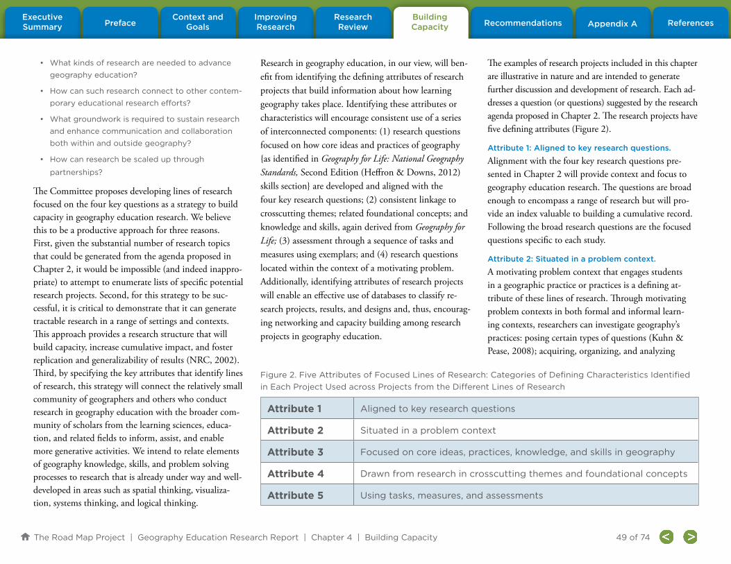
The Road Map Project | Geography Education Research Report | Chapter 4 | Building Capacity
PrefaceContext and
GoalsBuilding Capacity
Research Review Appendix A References
Improving Research Recommendations
Executive Summary
49 of 74
• What kinds of research are needed to advance
geography education?
• How can such research connect to other contem-
porary educational research efforts?
• What groundwork is required to sustain research
and enhance communication and collaboration
both within and outside geography?
• How can research be scaled up through
partnerships?
The Committee proposes developing lines of research focused on the four key questions as a strategy to build capacity in geography education research. We believe this to be a productive approach for three reasons. First, given the substantial number of research topics that could be generated from the agenda proposed in Chapter 2, it would be impossible (and indeed inappro-priate) to attempt to enumerate lists of specific potential research projects. Second, for this strategy to be suc-cessful, it is critical to demonstrate that it can generate tractable research in a range of settings and contexts. This approach provides a research structure that will build capacity, increase cumulative impact, and foster replication and generalizability of results (NRC, 2002). Third, by specifying the key attributes that identify lines of research, this strategy will connect the relatively small community of geographers and others who conduct research in geography education with the broader com-munity of scholars from the learning sciences, educa-tion, and related fields to inform, assist, and enable more generative activities. We intend to relate elements of geography knowledge, skills, and problem solving processes to research that is already under way and well-developed in areas such as spatial thinking, visualiza-tion, systems thinking, and logical thinking.
Research in geography education, in our view, will ben-efit from identifying the defining attributes of research projects that build information about how learning geography takes place. Identifying these attributes or characteristics will encourage consistent use of a series of interconnected components: (1) research questions focused on how core ideas and practices of geography {as identified in Geography for Life: National Geography Standards, Second Edition (Heffron & Downs, 2012) skills section} are developed and aligned with the four key research questions; (2) consistent linkage to crosscutting themes; related foundational concepts; and knowledge and skills, again derived from Geography for Life; (3) assessment through a sequence of tasks and measures using exemplars; and (4) research questions located within the context of a motivating problem. Additionally, identifying attributes of research projects will enable an effective use of databases to classify re-search projects, results, and designs and, thus, encourag-ing networking and capacity building among research projects in geography education.
The examples of research projects included in this chapter are illustrative in nature and are intended to generate further discussion and development of research. Each ad-dresses a question (or questions) suggested by the research agenda proposed in Chapter 2. The research projects have five defining attributes (Figure 2).
Attribute 1: Aligned to key research questions.
Alignment with the four key research questions pre-sented in Chapter 2 will provide context and focus to geography education research. The questions are broad enough to encompass a range of research but will pro-vide an index valuable to building a cumulative record. Following the broad research questions are the focused questions specific to each study.
Attribute 2: Situated in a problem context.
A motivating problem context that engages students in a geographic practice or practices is a defining at-tribute of these lines of research. Through motivating problem contexts in both formal and informal learn-ing contexts, researchers can investigate geography’s practices: posing certain types of questions (Kuhn & Pease, 2008); acquiring, organizing, and analyzing
Attribute 1 Aligned to key research questions
Attribute 2 Situated in a problem context
Attribute 3 Focused on core ideas, practices, knowledge, and skills in geography
Attribute 4 Drawn from research in crosscutting themes and foundational concepts
Attribute 5 Using tasks, measures, and assessments
Figure 2. Five Attributes of Focused Lines of Research: Categories of Defining Characteristics Identified
in Each Project Used across Projects from the Different Lines of Research

The Road Map Project | Geography Education Research Report | Chapter 4 | Building Capacity
PrefaceContext and
GoalsBuilding Capacity
Research Review Appendix A References
Improving Research Recommendations
Executive Summary
50 of 74
geographic information; and explaining and communicat-ing about geographic patterns and processes.
Attribute 3: Focused on core ideas, practices, knowl-edge, and skills in geography.
Core geographic ideas, practices, knowledge, and skills that are key to geography are central (Figure 3). The core ideas, practices, knowledge, and skills in geography are described in the Skills section of Geography for Life.
Attribute 4: Drawn from research in crosscutting themes and foundational concepts.
The themes relevant to both geography and other dis-ciplines are highlighted to make potential connections between geographic practices and education research in other fields. Such “crosscutting” themes include space, systems, scale, and change (Figure 3). The Committee rec-ognizes that it also is essential to identify the foundational concepts, and prerequisite knowledge and skills required to accomplish the sequence of tasks that comprise the geographic practices under investigation.
Attribute 5: Using tasks, measures, and assessments.
Developing sequential tasks, activities, or experimental treatments along with measures to assess each research objective is a key attribute of these lines of research. It is important that the tasks, measures, and assessments can be shared across settings with other individuals and groups of researchers. Tasks are especially relevant to the development of learning trajectories as they can both support student learning at a particular level during a lesson and foster higher levels of sophistication over time (Sztajn, Confrey, Wilson, & Edgington, 2012). For example, in research on curricular and program designs, we imagine each task, measure, and assessment will be de-signed as a coherent series of intended learning activities with the designated measures to assess the impact of the
Crosscutting Themes: (Derived from the
Essential Elements)
Core Ideas: (Derived from the 18 Standards)
Space
Scale
The World in Spatial Terms
1. Maps and other geographic representations communicate geographic
information in a spatial context.
2. Mental maps organize information about people, places, and environments in a
spatial context.
3. People, places, and environments are arranged in patterns on Earth’s surface.
4. Places have physical and human characteristics.
5. People create regions to interpret Earth’s complexity.
6. Culture and experience influence people’s perceptions of places and regions.
7. Physical processes shape the patterns of Earth’s surface.
8. Ecosystems and biomes have varied characteristics and distributions on
Earth’s surface.
9. Human populations have varied characteristics, distributions, and migration
patterns on Earth’s surface.
10. Earth’s cultures have a complex variety of characteristics and distributions.
11. Economic activities produce varied patterns and networks of interdependence
on Earth’s surface.
12. Human settlement varies by process, pattern, and function.
13. The forces of cooperation and conflict among people influence the division
and control of Earth’s surface.
14. Human actions modify the physical environment.
15. Physical systems affect human systems.
16. The meaning, use, distribution, and importance of resources change over time.
17. Geography provides insights and clues for interpreting the past.
18. Geography can help to interpret the present and plan for the future.
Places
Places and Regions
Systems
Physical Systems and Human Systems
Human-Environment Interaction
Environment and Society
Change
The Uses of Geography
Figure 3. Crosscutting Themes and Core Ideas in Geography for Life
Source: Adapted from Geography for Life (Heffron & Downs, 2012).

The Road Map Project | Geography Education Research Report | Chapter 4 | Building Capacity
PrefaceContext and
GoalsBuilding Capacity
Research Review Appendix A References
Improving Research Recommendations
Executive Summary
51 of 74
learning activities. Research possessing this supports the strategy of building capacity in geography educa-tion research through the development of exemplary tasks, measures, and assessments.
Examples of Lines of Research
The research projects described here illustrate examples of fruitful lines of research. Each description includes the attributes described above and is written to commu-nicate what we consider to be key features of research that will advance the agenda in geography education.
The illustrative research projects focus on different research questions, serve different purposes, and take place in diverse settings.
The first project, Developing Proficiency in Geographic Inquiry: Geospatial Tools in Informal Learning Settings, is related to research question 1. It describes research on geographic learning in an informal setting and addresses important questions about ways students develop profi-ciency in geography using geospatial technologies.
The second line of research described, Site Location: Why There? is an example of a curriculum unit simula-tion that investigates how learners use geographic practices to make spatial location decisions; in this instance, where to locate a landfill. The unit could be adapted to focus on site location in other contexts to explore the ways geographic knowledge, skills, and practices develop across the different elements of geog-raphy, research question 2.
The third line of research described, Contingent Pedagogies, is an example of a research and development project testing new diagnostic assessments of student
thinking. It addresses issues raised by research ques-tion 3: What supports or promotes the development of geographic knowledge, skills, and practices? Elements of this project also could address research question 4 by investigating teachers’ adoption of the innovations introduced in the project.
The fourth line of research, Using Maps in the Environ-ment, explores essential questions raised by research ques-tion 1, how individuals learn to use and interpret maps in different settings. It illustrates the important insights offered by cognitive science research into understanding how proficiencies in geographic practices develop, and it includes suggestions for instructional strategies based on the research related to research question 3.
Research Project 1. Developing Proficiency in Geographic Inquiry: Geospatial Tools in Informal Learning Settings
This line of research focuses on ways students develop proficiency in geographic inquiry augmented by the use of geospatial technologies, in this case, global position-ing systems (GPS) and online GIS. The research setting is a neighborhood youth center that runs an after-school program for secondary school aged students. Informal settings can offer an appropriate venue for multidisci-plinary or partnered projects with other researchers. A community program focused on the theme of com-munity change provides the context for the research. To focus learners’ attention on change, the researchers concentrate on two questions: Where is “downtown” and how has the downtown landscape evolved?
The researchers develop a series of tasks and activities, some technology enhanced, to allow them to observe, measure, and understand student learning and mastery
of geographic practices. To address the first ques-tion, students are encouraged to talk about their ideas of “downtown” and to decide what physical/visible and “sound” markers delimit this region. How many businesses are located on each block and what kind of businesses (stores) are present? Are there parking me-ters or parking lots? What is the density of population? How many trees are planted? How long are the blocks between intersections? What is the level of noise? This phase of the research is followed by data collection to address these questions. Students use hand-held GPS units to “mark” observations in the field, for example, a corner where it is especially noisy or where cars honk, intersections where more than three cars sit at a stoplight, or locations where people are engaged in specific types of activities. These “tagged” activities, events, and objects are transferred from the GPS devic-es to an existing digital street map. The students see the locations of their observations and begin to analyze the patterns they observe in order to define “downtown.” They overlay their information on an older map of the city (part of a digital collection) to see where boundar-ies might have shifted over time and then explain the changes they observe.
To address the second question of how the landscape of downtown evolved over time, the researchers ask students to formulate a geographic question; acquire, organize, and analyze geographic information; and develop an explanation of the patterns and processes they observe. Students use a series of pictures from the city library’s historical collection that clearly show trees in front of buildings that still stand on the city square to figure out where the photographer stood to take the his-torical photos. Students view new digital pictures taken

The Road Map Project | Geography Education Research Report | Chapter 4 | Building Capacity
PrefaceContext and
GoalsBuilding Capacity
Research Review Appendix A References
Improving Research Recommendations
Executive Summary
52 of 74
from the same vantage point, compare past and present measurements of the trees, and perform other analyses to mimic geographic practices. Their final task is to up-load the new digital pictures to HistoryPin (http://www.historypin.com) and to scale and align their photos accurately on the site’s aerial/image map (a simple form of georeferencing to an elevational perspective—in this case, the street view).
Characteristics of the line of research include:
Attribute 1: Aligned to key research questions.
The project is aligned with research question 1 and explores the following questions: What role does devel-oping explanations and geographic vocabulary play in enhancing the understanding of key concepts and prac-tices? How do learners come to understand geographies through geographic inquiry (the practice of geography)? How do learners understand the concept of translat-ing measurements from images to the real world? Does this vary by age, gender, socioeconomic status, or use of models? How do inquiry and field experiences affect geography learning?
Attribute 2: Situated in a problem context. The project explores the past and present in the local community using technologies and fieldwork.
Attribute 3: Focused on core ideas, practices, knowl-edge, and skills in geography.
The project engages all three geographic practices (for-mulating geographic questions; acquiring, organizing, and analyzing geographic information; and explaining and communicating geographic patterns and processes) and develops seven core ideas. Core ideas include: Maps and other geographic representations communicate information in a spatial context (Standard 1); People,
places, and environments are arranged in patterns on Earth’s surface (Standard 3); Places have physical and human characteristics (Standard 4); People create regions to interpret Earth’s complexity (Standard 5); Culture and experience influence people’s perceptions of places and regions (Standard 6); Human settlement varies by process, pattern, and function (Standard 12); and Geography provides insights and clues for interpreting the past (Standard 17). The knowledge and skills ad-dressed include: identify patterns in human, social, and cultural contexts; use of GPS and web-based mapping technologies; determine scale and calculate measure-ments using a combination of images and real world ob-jects; georeference a photograph onto a digital interface; and determine perspective or vantage.
Attribute 4: Drawn from research in crosscutting themes and foundational concepts.
The project examines crosscutting themes: space, places, systems, and change. It also examines these foundational concepts: density, boundaries, edges, patterns, scale, per-spective, representations, and change over time and space.
Attribute 5: Using tasks, measures, and assessments.
The activities focusing on geographic inquiry in an urban environment could be shared and replicated with other populations in different settings.
Research Project 2. Site Location: Why There?
This line of research focuses on an important geogra-phy activity—selecting an optimal location. It uses a simulation strategy to engage learners in making an in-formed decision about the best location for a landfill. Participants use a range of criteria to reach their deci-sion and are compelled to consider complex and con-tradictory information. The project explores aspects of
both research question 1 and research question 2. This simulation could be adapted to different site loca-tion tasks (e.g., the best location for a new school or a skateboard park) appropriate for younger and older learners, and it could be conducted in various con-texts, including both formal and informal educational settings. The purpose of the research is to begin to bet-ter understand the development of geographic knowl-edge, skills, and practices in individuals, settings, and time as well as across the elements of geography.
The researchers designed, piloted, refined, and stan-dardized the simulation to feature many geographic practices that can be assessed or measured, including developing, analyzing, and interpreting a map with multiple data layers; formulating geographic research questions; and developing and communicating an-swers to geographic questions. Researchers carefully established how they would measure the outcomes of the simulation and what evidence of student learning they would collect to address the research questions.
The simulation challenged learners to locate a sanitary landfill within a government jurisdiction while con-sidering multiple variables. The students were asked to work in teams, and were provided with resources to help with the analysis required for this activity. The resources included soil, topographic, hydrologic, land use, and geologic maps; a link to online Landsat images of the community; and information about government policies that inform the regulations and limitations for landfill locations as well as for the safe handling (collection, transport, and storage) of waste. The simulation gave students the opportunity to syn-thesize the information obtained from these sources

The Road Map Project | Geography Education Research Report | Chapter 4 | Building Capacity
PrefaceContext and
GoalsBuilding Capacity
Research Review Appendix A References
Improving Research Recommendations
Executive Summary
53 of 74
and to build a more sophisticated understanding of the factors that influence site location decisions, notably distance and land use patterns. A role-playing activity culminated with each team identifying a potential site for the landfill; developing a presentation using maps, satellite images, community-based data, and any other information they acquired about their site; and each team discussing the advantages and disadvantages of the location they selected.
Characteristics of the line of research include:
Attribute 1: Aligned to key research questions.
The project is aligned with research questions 1 and 2; it explores the following questions: How do students formulate geographic questions to solve a problem using geographic information? Do the questions differ when students use spatially represented data versus using narrative data? How do students use geographic representations in problem solving? How many vari-ables are manageable by students at different ages? At what level of complexity do students analyze geo-graphic information for one variable (e.g., distance)? What approaches do students use with multiple maps of different variables to solve a problem? Do these ap-proaches differ between males and females? Do these approaches differ with students in different age groups?
Attribute 2: Situated in a problem context.
The project is a role playing simulation of a site loca-tion problem.
Attribute 3: Focused on core ideas, practices, knowl-edge, and skills in geography.
The project engages all three geographic practices (for-mulating geographic questions; acquiring, organizing, and analyzing geographic information; and explaining
and communicating geographic patterns and processes) and develops four core ideas. Core ideas include: Maps and other geographic representations communicate information in a spatial context (Standard 1); People, places, and environments are arranged in patterns on Earth’s surface (Standard 3); Ecosystems and biomes have varied characteristics and distributions on Earth’s surface (Standard 8); and Physical systems affect human systems (Standard 15). The knowledge and skills de-veloped include: soil types and characteristics; variables that affect travel, including distance, road conditions, traffic controls, and the like; ideas about land use and physical landforms; how to formulate geographic ques-tions based on available information; how to identify and then construct overlay maps with different data sets to answer questions; and how to locate and investigate public documents or records.
Attribute 4: Drawn from research in crosscutting themes and foundational concepts.
The project addresses the following crosscutting themes: space, place, systems, and human-environment in-teraction. It also develops the following foundational concepts: spatial patterns and relationships, distance, location, place.
Attribute 5: Using tasks, measures, and assessments.
The simulation is a task that can be adapted for use in a range of contexts. It can be measured by “talk aloud” protocol asking students to talk through their analysis of multiple data layers and to explain their conclusions based on the data provided. Additional assessments include: analysis of a team’s presentation for key terms or procedures to identify approaches or the level of complexity of the analysis; and presenting students with a new simulation problem (for example, selecting the
location of a school) to evaluate if students can transfer knowledge or skills from the original to the new task.
Research Project 3. Contingent Pedagogies4
This line of research examines the effect of two strategies on student understanding and retention of geography knowledge: engaging learners in the geographic practices of using maps, analyzing spatial patterns, and explain-ing spatial variability; and integrating assessments into an existing curriculum. This project is an example of research focused on research question 3: What supports or promotes the development of geographic knowledge, skills, and practices? The research also is relevant to re-search question 4. Researchers and teachers co-developed assessment tools and strategies to provide teachers with insight about students’ understanding of geography content prior to being taught the curriculum, result-ing in a powerful professional development experience. This project also could explore research question 2 by comparing whether these strategies were equally effective across elements of geography content.
The context for this research was an existing physical geography curriculum featuring a unit on weathering and erosion and a unit on plate tectonics and earthquakes. Students used maps to explore the content and then an-swered a set of multiple-choice questions to help teachers assess understanding at the end of the lesson. The assess-ment component contained a number of tools to help teachers elicit and develop student understanding of core ideas. The answers to each assessment question reflected either a correct understanding of the material or a typical
4 This line of research is adapted from an ongoing project of the same name; find more information at http://ctl.sri.com/projects/display-Project.jsp?Nick=contingent

The Road Map Project | Geography Education Research Report | Chapter 4 | Building Capacity
PrefaceContext and
GoalsBuilding Capacity
Research Review Appendix A References
Improving Research Recommendations
Executive Summary
54 of 74
misconception about map representation that would lead to poor learning performance. Collecting this informa-tion was accomplished through the use of “clickers” (student response systems). The student responses were displayed, and after students saw how they had answered, the teacher asked volunteers to offer explanations for each answer. What typically followed was a rich discussion of the choices, and more often than not, without teacher intervention, the students converged toward the correct understanding of the main points in the lesson.
This quasi-experimental study was conducted in several classes in the same school district; teachers self-selected into the treatment or comparison groups. Learning gains of students in Contingent Pedagogies classes were compared with gains of students in other classes that used the same curriculum but did not have access to the innovative assessment strategies. The results of this study indicated that student scores were higher in the Contingent Pedagogies classrooms than in the other classrooms, even after controlling for baseline differences in scores. The project demonstrates that assessment can be used to improve learning as it occurs, not just as a means to evaluate it once the lesson is completed (see Black & Wiliam, 1998). The researchers’ ongoing analy-ses of classroom conversation are intended to identify what kinds of academically productive “talk moves,” (asking a student to apply and restate their own interpre-tation to someone else’s reasoning) (Resnick, Michaels, & O’Connor, 2010) contribute to student learning gains. Thus, this research increases understanding of the strategies that promote the development of geographic thinking, particularly with respect to the explanation of geographic patterns and processes.
Although the researchers did not investigate differences between the unit focused on weathering and erosion and the unit focused on plate tectonics, it would be possible to compare how the development of geographic knowledge differs between them and to analyze how the practices associated with each learning compare (research question 2). Future research might investi-gate which professional development components and district conditions are necessary to bring about greater implementation of Contingent Pedagogies, so the gains observed in the host district could be replicated else-where (research question 4).
Characteristics of the line of research include:
Attribute 1: Aligned to key research questions.
The project is aligned with research questions 3 and 4 and explores the following questions: What kinds of classroom strategies (classroom talk; formative assess-ment; using maps) contribute to student learning gains in geography? How does the development of geographic knowledge differ for supporting student understanding of plate tectonics and processes of weathering and ero-sion? Which professional development components and district conditions are necessary to support the effective and broad implementation of Contingent Pedagogies?
Attribute 2: Situated in a problem context.
The project uses map-driven exploration of physical geography and consequent class discussion.
Attribute 3: Focused on core ideas, practices, knowl-edge, and skills in geography.
The project engages all three geographic practices (formu-lating geographic questions; acquiring, organizing, and analyzing geographic information; and explaining and communicating geographic patterns and processes), and
it develops three core ideas. Core ideas include: Maps and other geographic representations communicate informa-tion in a spatial context (Standard 1); People, places, and environments are arranged in patterns on Earth’s surface (Standard 3); and Physical processes shape the patterns of Earth’s surface (Standard 7). Knowledge and skills include: the locations of mountain ranges, deep ocean trenches, ocean floor structures, earthquakes, and volca-noes occur in patterns; and maps can help locate features of Earth’s surface, including mountains and the outlines of the continents and oceans.
Attribute 4: Drawn from research in crosscutting themes and foundational concepts.
The project addresses the following crosscutting themes: space, systems. It also develops several foundational concepts: patterns and processes, scale, representations, change over time and space.
Attribute 5: Using tasks, measures, and assessments.
The classroom procedures can be replicated across projects. Objective, standards-based measures of student learning, in this case, items developed by the research team in collaboration with teachers, can be used.
Research Project 4: Using Maps in the
Environment5
This line of research focuses on the cognitive foundations needed for learners to deeply understand maps and their relationship to the real world. An essential part of map use is understanding the connection between the real, physical world and representations of it; that is, between maps and the environments they portray. Relatively little is known about how individuals link a large-scale environment they
5 This line of research draws heavily from Kastens and Liben (2007) and Kastens and Liben (2010).

The Road Map Project | Geography Education Research Report | Chapter 4 | Building Capacity
PrefaceContext and
GoalsBuilding Capacity
Research Review Appendix A References
Improving Research Recommendations
Executive Summary
55 of 74
have experienced with a map of that area. This research explores the cognitive prerequisites such as the ability of learners actually “in a space” to take the perspective needed to understand information represented on a map. Individuals must possess this skill to develop a more so-phisticated understanding of maps, an understanding that allows learners to see patterns in authentic contexts “from above” that would otherwise be invisible to someone “on the ground.” The research aligns with research question 1 (in this case, how individuals develop basic spatial skills over time). However, the research project is tied to research question 3 because it investigates the types of instruction that support the development of the cognitive skills essen-tial for children’s development of mapping skills.
The research took place in a park where learners, re-cruited from several local schools, participated in an ex-perimental treatment configured as a treasure hunt. The entire park was not visible from any single vantage point because of its large size and dense vegetation. Each re-search subject was given an 8.5 x 11 inch color printed map (large scale) of the park with a map key, north arrow, and scale bar. Vegetation was displayed in green, water in blue, and buildings in red. An introductory training was provided to explain (1) how the map was oriented from the perspective of where the child was standing; (2) the direction the child was facing, (i.e., the frame of reference was described); (3) what each item of the map key represented; and (4) the nature of the task, finding eight treasures in the terrain and mark-ing them on the map with numbered stickers. As each treasure was located, learners were instructed to mark the location on their map with a sticker and to write an explanation of the clues used to make that decision.
Finding the location of the hidden treasures varied from easy to difficult, easy locations closer to landmarks and harder locations farther from landmarks. Children were given as much time as they needed to complete the task. Adults were positioned around the park to prevent students from going out of the park boundary. After the introduction, children were invited to ask questions and then to complete the activity.
Participants’ reports of the clues they used to place the stickers on the map provided the researchers with data that they used to identify strategies that led to improved performance. They identified four categories of com-mon errors leading them to conclude that children found it difficult to acquire relevant information from their environment and to use a map to guide observa-tions and decision making. As a result of this research, a series of recommendations for instruction in field settings was proposed.
Characteristics of the line of research include:
Attribute 1: Aligned to key research questions.
The project aligned with research questions 1 and 3 and explores the following questions: How do learn-ers develop the understanding that maps represent real places? What strategies and cognitive skills do learners use to successfully navigate with a map? What instruc-tional strategies are effective in helping students map field observations?
Attribute 2: Situated in a problem context.
The project requires a search for treasure in a park setting.
Attribute 3: Focused on core ideas, practices, knowl-edge, and skills in geography.
This research project engages the geographic practice
of acquiring, organizing, and analyzing geographic information and focuses on one core idea: Maps and other geographic representations communicate infor-mation in a spatial context (Standard 1). The project develops knowledge and skills, including: understand-ing map symbols, how to interpret map symbols, scale, understanding of spatial relations, and understanding of viewing direction and viewing angle.
Attribute 4: Drawn from research in crosscutting themes and foundational concepts.
The project addresses the following crosscutting themes: space, scale. It also develops several foundational concepts: orientation, reference, representation, scale, symbols.
Attribute 5: Using tasks, measures, and assessments.
The task and measures are replicable with different pop-ulations. The method of analysis of the maps produced and self-explanations regarding why each participant placed the sticker in a particular location can serve as a model for other researchers.
Summary
In conclusion, these illustrative examples of lines of research show how research can be coordinated, in-form future studies, and build capacity for research in geography education. By identifying the characteristics of the research using the five attributes described here, geography education researchers can connect with other research projects and leverage their findings and efforts as part of a focused, research agenda.

The Road Map Project | Geography Education Research Report | Chapter 5 | Recommendations
PrefaceContext and
GoalsBuilding Capacity
Research Review Appendix A References
Improving Research Recommendations
Executive Summary
56 of 74
This chapter presents a set of specific recommendations for researchers, educators, policy makers, and funders about the actions required to further develop and expand research in geography education. The recommendations summarize and focus attention to needs identified by the Committee in previous chapters. The goal of these recommendations is to improve learning and teaching in geography to develop a geographically proficient and literate society.
The chapter is organized in response to the two key charges to the Geography Education Research Committee:
• Charge 1: What areas of research will be most ef-
fective in improving geography education at
a large scale?
• Charge 2: What strategies and methodologies
can relevant research communities develop and
adopt to maximize the cumulative impact of edu-
cation research in geography?
Recommendations concerning Charge 1 are organized around the four key research questions explained in Chapter 2. The suggested research priority is based on gaps identified in Chapter 3. Recommendations con-cerning Charge 2 are based on the overarching review of research strengths and weaknesses discussed in Chapter 3 and on the Committee’s expertise. These recom-mendations advocate for individual and community efforts that together can maximize the research efforts in geography education.
A hierarchical order of recommendations is not implied as both charges are equally important. The Committee leaves it to the individuals and groups reading and responding to this report to prioritize the recommendations.
The recommendations follow a consistent format. Each is presented in a brief statement followed by a full descrip-tion of the rationale, context, and connection to compo-nents of the report.
Recommendations Focused on Charge 1:
What areas of research will be most effective in improving geography education at a large scale?
It is clear that geography education needs a focused, systematic research agenda. The Committee suggests a long-range plan for action organized around the four key research questions posed in Chapter 2, with a focus on the structural and developmental features of learning geographic knowledge, skills, and practices. This approach will allow geography educators to align curriculum, instruction, and assessment models; to establish coherent learning sequences rooted in a richer understanding of the cognitive strategies employed by learners; and to promote effective models of teaching. Committee recommendations center on research in learning progressions, curriculum and instruction, and teacher knowledge and preparation.
Research Question 1:
How do geographic knowledge, skills, and practices develop across individuals, settings, and time?
This question focuses on how individuals learn geog-raphy at different timescales and in different contexts. The Committee recommends research in this area; it is essential that we know how individuals in a range of set-tings and socioeconomic environments gain geographic knowledge, skills, and practices. Of particular importance is research about learning among children and youth from non-dominant communities. That notwithstand-ing, the Committee sets as a priority research in learning progressions that will produce a body of evidence about optimal pathways to achieve geographic proficiency.
Recommendation 1
The Committee recommends that geography
education researchers engage in systematic
efforts to identify learning progressions in
geography both within and across grade bands
(e.g., K–4, 5-8, 9-12).
Rationale: Such a research program in geography should investigate and provide a set of learning tra-jectories that frame geography teaching and learning. The goal of developing learning progressions is to establish core geographic ideas that are coupled with using knowledge, skills, and practices. The Committee believes that empirical research that tests hypothetical learning progressions will advance our understanding of student learning and provide guidance to the design
Chapter 5: Geography Education Research Committee Recommendations

The Road Map Project | Geography Education Research Report | Chapter 5 | Recommendations
PrefaceContext and
GoalsBuilding Capacity
Research Review Appendix A References
Improving Research Recommendations
Executive Summary
57 of 74
of standards, assessments, and shared tasks and activities. Research should study whether learning progressions that function across broader month- and year-long units of time can be identified. In other education domains, notably science, studies occurring over longer units of time have provided a promising format for understand-ing the potential pathways for learning. Additionally, research could help identify the curricular and cultural contexts where such progressions might have relevance.
These learning progressions should focus on the foun-dational knowledge, skills, and experiences necessary for developing geographic competency for a range of indi-viduals and ages. Geography for Life: National Geography Standards, Second Edition (Heffron & Downs, 2012) suggests a sequence for learning, but a research base with tested methods for teaching and implementation is needed. Research to empirically identify the knowl-edge, skills, and practices appropriate at different grade levels conducive to improving geographic learning is necessary. Attention should be paid to how individuals learn in both formal and informal educational contexts. Researchers also should test how well the data on actual learning and development pathways fit hypothetical and alternate developmental models.
Further, research on learning progressions that are connected to the “grand challenges” identified by the National Research Council (2010) such as sustain-ability and natural hazards, are inherently geographic, interdisciplinary, and needed. Many of the current societal, national, and international problems require an interdisciplinary perspective to be addressed adequately. Supporting students’ development of the geographic knowledge, skills, and practices necessary to understand
these problems requires research on learning progressions in both domain-general (e.g., spatial reasoning, systems modeling, geospatial technologies) and domain-specific, interdisciplinary (e.g., watershed resources manage-ment; reading and interpreting maps and Earth images) contexts. Establishing effective learning progressions also requires research about effective curriculum design and implementation, the topic for Recommendation 2.
Research Question 2:
How do geographic knowledge, skills, and practices develop across the different elements of geography?
Developing geographic knowledge, skills, and practices varies with the aspect of geography under study. The Committee recognizes that geography includes both physical and social science content and that the ele-ments of geography play a role in the teaching/learning process, in both the traditional and emerging approaches to schooling. The field needs research that explores the ways content shapes the skills and practices critical to geographic proficiency. This is especially important to fully achieve the goals identified in Geography for Life. However, as a priority, the Committee recommends a focus on translating such research into curricula whose efficacy in advancing geographic learning for all students can be evaluated empirically.
Recommendation 2
The Committee recommends research that exam-
ines the components and characteristics of exem-
plary geography curricula.
Rationale: The Committee recognizes that students arrive at every potential educational encounter (whether in classroom, museum, family, or other contexts) with
various interests, cognitive skills, experiences, and knowledge, and we recognize that students’ individual characteristics affect how they understand and apply new material, and indeed, their motivation to do so. Although research in fields such as developmental psychology, educational psychology, cognitive psychology, and learn-ing sciences (among others) provides a rich collection of evidence on which to draw, it is not yet sufficiently well-developed in all relevant areas, nor has this research been adequately integrated into geographic curriculum design and evaluation. Well-designed, systematic research is needed to expand the understanding of cognitive foun-dations, task characteristics, and organizational condi-tions that should inform the design, implementation, and evaluation of geography curriculum across its different elements, including those that connect to geospatial technologies, physical and human systems, and human-environment interactions. Additional research is needed not only to understand the characteristics of exemplary geography curricula, but also to understand the roles of teachers in adapting and implementing core ideas of geography, including support for diverse learners.
Research Question 3:
What supports or promotes the development of geographic knowledge, skills, and practices?
This research question focuses broadly on teaching and also addresses other aspects of support systems for learn-ing, including the use of geospatial technologies and fieldwork for learning geography. The Committee places a priority on understanding the efficacies of different teaching strategies, including fieldwork and using geospa-tial technologies, to develop proficiency in geography.

The Road Map Project | Geography Education Research Report | Chapter 5 | Recommendations
PrefaceContext and
GoalsBuilding Capacity
Research Review Appendix A References
Improving Research Recommendations
Executive Summary
58 of 74
Recommendation 3
The Committee recommends research to
investigate the characteristics of effective
geography teaching.
Rationale: Policy makers and teacher educators need a richer understanding of what constitutes effective teaching of geography if the recommendations of the Road Map Project are to be implemented successfully. Teachers have the ultimate responsibility for implement-ing curricular and instructional change. We also need to understand what practices characterize or define effec-tive geography teaching and how teachers’ pedagogical decisions impact student achievement and performance. The answers to these questions will advance the field by identifying the pedagogical content knowledge teachers must have to develop geographically literate students. It also will be important to understand the instructional strategies that promote and support geography learning most effectively.
The National Geography Standards specifies content and skills in K–12 geography but does not discuss how that content should be taught. In 2006, the Geography Education National Implementation Project (GENIP) sought to create a definition of a highly qualified K–12 geography teacher in response to the No Child Left Behind Act (2002). Since that time, research connecting teacher knowledge and skills to classroom effectiveness and student achievement has become an important com-ponent of the overall school accountability movement. Research has shown:
• Teachers who have more experience (generally
around five years) perform better than novices
in producing student learning.
• Teachers who have deep content knowledge
and pedagogical content knowledge, who know
how to manage a classroom effectively, who
know their students well, and who believe that
they can succeed all contribute positively to stu-
dent learning.
• Teachers who engage in professional develop-
ment foster more ambitious teaching and learn-
ing in schools.
In sum, understanding the extent to which these teacher attributes affect geography teaching will be critical in shaping both teacher education and the licensing of future geography teachers.
Recommendation 4
The Committee recommends research about
fieldwork and its impact on learning geography
knowledge, skills, and practices.
Rationale: Geography is learned by: (1) making observations, formulating questions, and collecting data about people, places, and the environment and its dynamics; (2) analyzing the data; and then (3) explain-ing and even predicting the consequences for human and physical systems. Fieldwork, whether virtual or real, focused on human systems, physical systems, or both, offers stimulus for students to engage in research and to learn content through real-world experiences. Fieldwork has long been recognized as a fundamental component of geography, yet how the practice can be best incorpo-rated into formal and informal learning environments, and how to measure and optimize its effectiveness, is not widely understood. This is especially true with respect to geospatial and multimedia technologies that offer virtual field experiences, a practice that may
become more common and may augment, or substitute for, real-world, field-based experiences.
Research Question 4:
What is necessary to support the effective and broad imple-mentation of the development of geographic knowledge, skills, and practices?
To improve the quality and quantity of geography education in the United States, we need research about effective ways to implement change in the educational system. This includes a broad understanding of teacher preparation, professional development, and strategies for effective implementation of educational innova-tion. The Committee believes research concerning teacher preservice preparation and inservice professional development is a priority. Equally important is research regarding strategies for measuring and improving the organizational and institutional conditions necessary to support change in geography education. One model for such work could be design-based implementation research that focuses on designing and testing supports required for the scaling up of programs (Penuel, Fishman, Cheng, & Sabelli, 2011).
Recommendation 5
The Committee recommends that research about
teacher preparation in geography be conducted
with the goal of determining what is needed to
produce educators able to understand and teach
for student mastery of the content and practices
of geography.
Rationale: While research supports the assumption that teacher content knowledge has a positive effect on student learning, the relationship between teachers’

The Road Map Project | Geography Education Research Report | Chapter 5 | Recommendations
PrefaceContext and
GoalsBuilding Capacity
Research Review Appendix A References
Improving Research Recommendations
Executive Summary
59 of 74
knowledge of geography content and skills and student achievement is not fully understood. More research about the most effective means of teaching geography, with and without technology, across K–12 classrooms is required. Close attention to the content knowledge and pedagogical content knowledge necessary for effective teaching of geographic concepts, skills, and practices to foster geographic literacy is needed. Research also is needed about the optimal ways to infuse geographic concepts, content, and skills into geography and other disciplinary preservice programs. The field also must pay attention to the impact of licensure in science or social studies on teacher preparation to teach geography. This research should extend to consider inservice programs. Research also should address teachers’ beliefs about geography and how these beliefs shape the implementa-tion of practices in geography.
Recommendations Focused on Charge 2:
What strategies and methodologies can
relevant research communities develop and
adopt to maximize the cumulative impact of
education research in geography?
Building capacity in geography education research will require additional financial support beyond what is currently available. The Committee strongly believes that new investments in geography education research should be prioritized to maximize the cumulative im-pact of the research. The Committee recommends the development of interdisciplinary and multidisciplinary research communities working in a range of settings and at a variety of scales; the creation of exemplars; the establishment of research partnerships; and the
development of institutional support systems in geogra-phy education research.
Recommendation 6
The Committee recommends interdisciplinary and
multidisciplinary approaches, drawing on relevant
research results.
Rationale: Geography is an inherently interdisciplinary field, and it has the potential to catalyze interactions among various disciplines, including the humanities and the social and natural sciences. Conducting cross- or inter-disciplinary research is not easy. Researchers sometimes disagree on what research questions are most important or which methods are most appropriate. Fortunately, models of interdisciplinary cooperation can provide guidance for future work.
One example is the National Science Foundation (NSF)-funded Science of Learning Centers (SLC). NSF’s goal in establishing this program was to meet the challenges of STEM learning in the 21st century by fostering interdisciplinary science and research. The Centers bring together researchers from a variety of fields, including cognitive psychologists, education research-ers, and domain specialists (e.g., scientists, engineers, and mathematicians). Most relevant to our effort is the Spatial Intelligence and Learning Center (SILC), which has focused on the role of spatial thinking in STEM education. SILC’s cognitive psychologists, education researchers, computer scientists, geoscientists, and engineers work together on fundamental topics, such as understanding and facilitating students’ reasoning in the geosciences. SILC’s success is proof that fruitful interdis-ciplinary cooperation is possible and beneficial.
Recommendation 7
The Committee recommends that geography edu-
cation researchers follow established principles
for scientific research in education (NRC, 2002)
and that they collect data scientifically from large
samples of students in schools, other natural
learning environments, and laboratory settings.
Rationale: Collectively, geography education research lacks large-scale and longitudinal studies (see Chapter 3). This trend must be reversed. Small sample sizes compromise the statistical power of research findings and hamper our ability to generalize across settings. The Committee believes that research based on large samples collected using statistically appropriate methods will allow the findings to be fully articulated with classroom practice, and that such large-scale research will produce reliable and valid generalizations. One strategy to achieve this goal is to conduct research in collaboration with interested geography educators or teachers. This would permit researchers to conduct projects that could be rep-licated in other settings by other researchers. In addition, a variety of experimental designs to test interventions in curriculum and pedagogy should be investigated.
Recommendation 8
The Committee recommends researchers develop
and study exemplary programs, curricula, tasks,
measures, and assessments to build the body of
knowledge about effective geography teaching
and learning.
Rationale: We recommend that researchers develop and use exemplary items (exemplars) to build an understanding about how people develop geography skills (formulating geographic questions; acquiring,

The Road Map Project | Geography Education Research Report | Chapter 5 | Recommendations
PrefaceContext and
GoalsBuilding Capacity
Research Review Appendix A References
Improving Research Recommendations
Executive Summary
60 of 74
organizing, and analyzing geographic information; and explaining and communicating geographic patterns and processes). In general, an exemplar is a widely accepted application of a core disciplinary theory or method that can be used as an example or aid in solving other similar problems (Kuhn, 1970). As we mean it here, an exemplar is an agreed upon focal point for research that can be used in common to develop and accumulate knowledge. Exemplars in cognitive science and educa-tion research have helped develop our understanding of individual learning differences (NRC, 2001b), the ef-ficacy of different teaching strategies (e.g., Savinainen & Scott, 2002), and methods to support implementation of reforms (e.g., Rowan & Miller, 2007).
Recommendation 9
The Committee recommends building partner-
ships with formal and informal educators to con-
duct research in a range of learning contexts and
to share findings among the community of geog-
raphy education researchers.
Rationale: Geography education research typically in-volves small numbers of students and is rarely replicated. Furthermore, geography and other subjects have become marginalized as a result of high stakes testing and the emphasis on literacy and numeracy, making it more dif-ficult to work with teachers and administrators to collect data about teaching and learning. Compounding this problem is the educational research paradigm that treats schools, teachers, and students as research subjects rather than as research partners. Building respectful partner-ships with districts, schools, and teachers can overcome this problem. Replicable research projects can provide another potentially productive research strategy. To
contribute to the accumulation of knowledge, such re-search projects must be grounded in learning theory and they must attack problems that are of interest to a wide variety of practitioners who teach in diverse contexts.
Recommendation 10
The Committee recommends the creation or
designation of an institution to coordinate the
implementation, dissemination, and knowledge
transfer of research results.
Rationale: The ability of the Road Map Project research agenda to inform and catalyze systemic changes in U.S.-based geography education is limited by the absence of a mechanism for coordinating research activities among scholars in geography and cognate fields. Only a large well-funded organization would have the resources neces-sary to plan, monitor, and execute the research required to reach the targets set forth in this report (e.g., replicat-ing studies performed in multiple locations). Moreover, traditional publication outlets such as academic journals, while still serving an essential peer-review purpose, do not ensure that key research findings will be disseminated broadly and in a manner that informs the work of practi-tioners. What is required, therefore, is an institution that: (1) regularly considers the status of research in geography education in relation to the key questions of the research agenda; (2) assesses when sufficient amounts of empirical evidence exist to shape decision making in educational practice; (3) recommends further research in areas where knowledge remains deficient; and (4) provides models to translate research into practices that will result in improved teaching and learning (e.g., enhanced programs for preservice and inservice teacher professional develop-ment, age-appropriate instructional materials designed
to promote the learning of geographic practices, and valid assessment instruments for measuring attainment of standards-based knowledge, skills, and practices). This institution would likely take the form of a research center based at a university or academic society. It should be led by a director and an advisory committee of individuals representing the organizations and disciplines involved in the research, and it should issue independent recommen-dations for research and action. The center also should be required to build a small number of specific international collaborations and links to pursue research projects with partners in other countries.
Recommendation 11
The Committee recommends development
of “learning research” opportunities. Pre- and
post-doctoral training programs, similar to NSF’s
Fostering Interdisciplinary Research on Education
(FIRE), can prepare participants for a range
of career opportunities that will promote and
disseminate geography education research.
Rationale: To enable geographers to conduct geography education research, we need to develop their education research skills. Graduate programs in geography generally follow the linear, academic model consisting of courses and dissertation research in a specific area. Currently, only a few doctoral students in the United States focus on geography education research. We recommend that the number of geographers with the skills and interests to conduct research at a range of grade levels be expanded through formal post-doctoral programs and training op-portunities funded by public and private sources.
The Committee believes professional development related to geography education will promote the following:

The Road Map Project | Geography Education Research Report | Chapter 5 | Recommendations
PrefaceContext and
GoalsBuilding Capacity
Research Review Appendix A References
Improving Research Recommendations
Executive Summary
61 of 74
(1) give researchers and graduate students a wider and deeper perspective of geography education as it is prac-ticed; (2) provide rich contexts within which to formulate relevant research questions; and (3) improve geogra-phers’ own practice through experiences and reflection. Experiences such as serving as a reader for the Advanced Placement Human Geography examination, contributing questions for national assessments, or interning at non-profit or governmental educational agencies also can help geographers increase their understanding of, and capacity to conduct research about, geography education.
Recommendation 12
The Committee recommends the development
and publication of a handbook that includes
online tools and exemplars and that suggests
areas in need of additional research.
Rationale: Geography education is a widely recognized subfield in geography, but research in this subfield has not earned broad recognition (Bednarz, Downs, & Vender, 2003). Of the 226 universities in the United States that offer degrees in geography, 72 institutions (32%) list geography education as a program specialty (Association of American Geographers, 2010). Most of these programs focus on teacher preparation rather than research in geography education. To build capacity within the subfield, the Committee recommends publication of a research handbook. This publication will serve both as a textbook for geography education graduate programs and as a forward-looking document that will inform gradu-ate students and faculty members about how to conduct
research to drive the research agenda. To date, only two research handbooks have been published (Gerber, 2003; Williams, 1996), and both feature a distinctly Anglo-Australian perspective. In the United States, single chap-ters on research in geography education have appeared in two editions of the Handbook of Research in Social Studies Education (Levstik & Tyson, 2008; Shaver, 1991). The field requires a handbook that covers geography education research methods; questions about the use of geospatial technologies in teaching geography; connec-tions with science and social science education research; and the design of standards, assessments, instructional tasks, and activities.
Recommendation 13
The Committee recommends that the National
Assessment of Educational Progress (NAEP) Geog-
raphy assessment be conducted at more frequent
and regular intervals and that more funding for
greater analysis of the test results be provided.
Rationale: The Committee recommends that state and national efforts to evaluate learners’ geographic knowl-edge, skills, and practices should be continued, that resources should be allocated to improve and expand them, and that additional analyses of the data collected be funded. The Committee believes that the collec-tion of data through national assessments is necessary to improve research in geography education. In the 2010-2011 academic year, fewer than one-third of states required an exit exam or end-of-course assessment that contained geography-related items. NAEP assesses the
geography knowledge and skills of students in elemen-tary, middle, and high schools across the United States, but these tests have been administered so infrequently that the development of cohort and longitudinal studies is impossible. Well-designed, properly timed assess-ments can provide researchers with crucial information they need to understand how students learn geography.
The Committee also suggests partnerships with assess-ment providers such as the College Board, Educational Testing Service (ETS), and Pearson to improve geogra-phy assessments and to increase the number of geogra-phy items embedded in other subject tests, providing additional data for research.
Summary
Geography education has great potential to develop and pursue an active research agenda. Geography education can leverage research in other domains of learning as well as work in the learning sciences to design research projects to answer questions about effective teaching and learning in geography. Researchers responding to the recommendations contained in this report will require financial support if they are to make progress in a timely fashion. Research results also will inform edu-cators working in other disciplines to provide a more comprehensive understanding of teaching and learning. In conclusion, high-quality research in geography edu-cation is needed and can serve to move the understand-ing of teaching and learning geography forward.

The Road Map Project | Geography Education Research Report | Appendix A | Geography Education Research Committee Biographies
PrefaceContext and
GoalsBuilding Capacity
Research Review Appendix A References
Improving Research Recommendations
Executive Summary
62 of 74
Sarah Witham Bednarz
ChairSarah Witham Bednarz is a Professor of Geography and Associate Dean for Academic Affairs for the College of Geosciences, Texas A&M University. She holds a University Professorship for Teaching Excellence and received the Gilbert H. Grosvenor Honors
for Geographic Education from the Association of American Geographers in 2007 and the George J. Miller Award from the National Council for Geographic Education in 2005. Most recently she served on the committee that revised the National Geography Standards.
Susan Gallagher Heffron
Co-ChairSusan Gallagher Heffron serves as the Senior Project Manager for Geography Education at the Association of American Geographers (AAG). In her current role, Dr. Heffron facilitates AAG projects for K–16 education with a special interest in K–12 teachers and learners. Recent
projects include serving on the writing committee and as an editor of Geography for Life: The National Geography Standards, Second Edition. Her work includes facilitating the dissemination of research to inform classroom and online instructional strategies as well as effective teacher professional development experi-ences. Dr. Heffron previously served on the National Council for Geographic Education's Research Committee and was awarded the NCGE President's Award for her work at the AAG in support of geography education.
Niem Tu Huynh
Research CoordinatorNiem Tu Huynh is a Senior Researcher at the Association of American Geographers (AAG). Prior to joining the AAG, she was an assistant professor in the Department of Geography at Texas State University – San Marcos. In this
position, she taught undergraduate courses as well as graduate geography education and technology courses. For her technology integration in the classroom, she won the Face-to-Face Category in the 2011 Teaching with Sakai Innovation Award. Dr. Huynh also has teaching experience in high school biology (IB), science, and geography in Toronto, Ontario (Canada). Her research interests include Geography and GIS education and she remains active in the geography education community by participating as a Reader for the Advanced Placement Human Geography (2012) course and as a judge for the National Geographic Bee (2012).
Margaret Smith Crocco
Committee MemberMargaret Smith Crocco is the Dean of the College of Education at the University of Iowa. She spent almost 20 years on the faculty of Teachers College, Columbia University in New York City. Her career and family life have provided a variety of geographic experiences in
suburban, urban, and now rural communities, from New Jersey to Texas to Iowa. In 2007, she and a team of educators completed the “Teaching The Levees” project based on Spike Lee’s award winning film about Hurricane Katrina, When the Levees Broke. The curricu-lum and film have been distributed to more than 40,000 schools, colleges, and community groups nationwide through the generos-ity of the Rockefeller Foundation. At the University of Iowa, Dr. Crocco is working with professors in the College of Education and the College of Engineering on developing an interdisciplinary sustainability curriculum for undergraduates and others.
Richard A. Duschl
Committee MemberRichard A. Duschl is the Waterbury Chair Professor of Secondary Education in the College of Education, Penn State University. Twice Dr. Duschl has received the ‘JRST Award’ for the outstanding research article published in the Journal of Research in Science Teaching. From
2008 to 2011, he served as president of National Association for Research in Science Teaching (NARST). He was editor of the research journal, Science Education, for more than a decade and
editor for TC Press Ways of Knowing in Science and Math book series. More recently he has served as chair of the National Research Council committee that wrote the research synthesis report Taking Science to School: Learning and Teaching Science in Grades K–8 (National Academies Press, 2007), and he was part of the 2009 NAEP Science Framework planning committee. Dr. Duschl cur-rently co-chairs the Earth/Space Sciences writing team for the Next Generation Science Standards.
David Lambert
Committee MemberDavid Lambert is a Professor of Geography Education at the Institute of Education, University of London. He was a high school teacher for 12 years and a teacher educator for 15 years. In 2002, he became full-time chief executive of the Geographical Association (GA), with
the aim of strengthening its role and influence in national policy matters and expanding its footprint as a source of professional sup-port and leadership for teachers of geography. In 2007, he managed to combine this with a part-time professorship at the Institute of Education a post he job-shared with John Morgan. He stepped down from GA leadership in summer 2012, returning full-time to his current post. In 2010 he co-authored Teaching Geography 11-18: A Conceptual Approach (Open University Press), and in 2012 he co-edited Debates in Geography Education (Routledge). In 2011 he guest edited a special edition of The Curriculum Journal (Vol. 22, 3) on geography education. His PhD studies focused on geography and prejudice reduction in school, and he also has published work on assessment, curriculum, and citizenship.
Lynn S. Liben
Committee MemberLynn S. Liben is a Distinguished Professor of Psychology at Penn State where she also holds faculty appoint-ments in the College of Health & Human Development and in the College of Education. Her research focuses on spatial cognition, its development, and
on how individual differences in spatial cognition are relevant for science education. Illustrative is research examining children’s
Appendix A: Geography Education Research Committee Biographies

The Road Map Project | Geography Education Research Report | Appendix A | Geography Education Research Committee Biographies
PrefaceContext and
GoalsBuilding Capacity
Research Review Appendix A References
Improving Research Recommendations
Executive Summary
63 of 74
and adults’ success in identifying locations and directions on maps, and adults’ success in mapping geological data. She has used her research to help design educational programs for television, muse-ums, and classrooms. Dr. Liben is currently president-elect of the Society for Research in Child Development, former president of the Piaget Society and the Developmental Psychology Division of the American Psychological Association (APA), and past editor of Child Development and the Journal of Experimental Child Psychology. She is a fellow of APA, Association for Psychological Science (APS), Eastern Psychological Association (EPA), and American Educational Research Association (AERA); her research has been funded by National Science Foundation, National Institute of Child Health and Human Development, Office of Educational Research and Improvement (OERI) (formerly National Institute of Education), and the National Geographic Society.
William Penuel
Committee MemberWilliam Penuel is a Professor in Educational Psychology and the Learning Sciences at the University of Colorado Boulder. His research focuses on teacher learning and organizational processes that shape the implementation of educational policies, school curricula, and after-school
programs. He has designed and evaluated a number of different programs for teacher professional development in Earth science education. These programs typically involve preparing teachers to make productive adaptations of high-quality curriculum materials. He also has examined strategies for scaling and sustaining programs in science education. Dr. Penuel’s research has appeared in the American Educational Research Journal, Teachers College Record, the American Journal of Evaluation, Science Education, and the Journal of the Learning Sciences. He is currently associate editor of the Social and Institutional Analysis section at the American Educational Research Journal. Dr. Penuel holds a PhD in developmental psychol-ogy from Clark University in Worcester, Massachusetts.
Eui-kyung Shin
Committee MemberEui-kyung Shin is an Associate Professor in the Department of Literacy Education at Northern Illinois University where she teaches undergraduate and graduate cours-es in social studies education. Her research and teaching efforts have been devoted to students’ learning of geographic thinking
in social studies, especially the integration of GIS technology into K–12 classrooms. Since 2002, Dr. Shin has made numerous presenta-tions at the National Council for Geographic Education (NCGE) meetings and published articles in journals such as the Journal of Geography, The Geography Teacher, Theory and Research in Social Education, and Social Studies and the Young Learner. Her doctoral dis-sertation received the first place NCGE dissertation award in 2004. She has served on various task forces such as the dissertation award task force and K–5 spatial thinking task force in the NCGE. She also serves on the Illinois Geographic Alliance’s steering committee, and is currently serving on an editorial board for the Journal of Geography.
Diana Stuart Sinton
Committee MemberDiana Stuart Sinton is the Director of Spatial Curriculum and Research at the University of Redlands (California) where she leads LENS (LEarNing Spatially), a campus-wide initiative to integrate map-ping and spatially informed ways of think-ing into diverse academic disciplines. She
teaches Foundations of Spatial Thinking for the School of Education’s Masters in Education degree in Spatial Literacy Curriculum and Instruction. Dr. Sinton’s research interests include the roles of geospatial technologies and spatial literacy in teaching and learning. Currently she works with the European Union’s Spatial Citizenship (SPACIT) project, providing teachers with the education to support spatial thinking and citizenship activities in the classroom. Her publications include The People’s Guide to Spatial Thinking (NCGE, forthcoming) and Understanding Place: GIS and Mapping across the Curriculum (Esri Press).
Michael Solem
Committee MemberMichael Solem is the Director of Educational Affairs for the Association of American Geographers. Dr. Solem cur-rently directs the Enhancing Departments and Graduate Education in Geography (EDGE) project and the Center for Global Geography Education (CGGE) initiative,
both funded by the National Science Foundation. He currently serves as the North American coordinator of the International Network for Learning and Teaching Geography in Higher Education (INLT), is associate director of the Grosvenor Center for Geographic Education at Texas State University–San Marcos, and is treasurer for the International Geographical Union’s Commission on Geographical
Education. Dr. Solem twice received the Journal of Geography in Higher Education’s award for promoting excellence in teaching and learning for his research on faculty development and graduate educa-tion in geography.
Joseph P. Stoltman
Committee MemberJoseph P. Stoltman is a Professor of Geography and Science Education at Western Michigan University, Kalamazoo, MI. He teaches undergraduate and graduate courses in both the geography and science education programs and directs doctoral student research in Geographical
Education: Physical Geography. He was editor of 21st Century Geography: A Reference Handbook (Sage Publishing, 2012). Other service includes; co-coordinator of the Michigan Geographic Alliance and president (2009) of the National Council for Geographic Education. He served as a member of the writing team for the second edition of Geography for Life: National Geography Standards (2012), and as an item writing and review committee member for the NAEP in Geography for 2010 and 2014. Dr. Stoltman’s awards include the George J. Miller Award for Distinguished Service (NCGE), the Gilbert Grovesnor Honors in Geographic Education (AAG), and the James Park Thomson Medal of the Royal Geographical Society of Australasia (Queensland), and Distinguished Faculty Scholar at Western Michigan University.
David Uttal
Committee MemberDavid Uttal is a Professor of Psychology and of Education at Northwestern University, where he also is director of the Cognitive Division of the Psychology Department and of the Multidisciplinary Program in Education Sciences. He is a member of the leadership group of the Spatial Intelligence
and Learning Center. He is a fellow of the American Psychological Association and the Association for Psychological Science and a char-ter fellow of the Midwestern Psychological Association. Dr. Uttal’s re-search focuses on the development of symbolic and spatial cognition. His most recent work focuses on the role of spatial thinking in STEM education. His research has been funded by the Institute of Education Sciences, National Science Foundation, National Institutes of Health, and the Spencer Foundation. He earned his PhD in Developmental Psychology from the University of Michigan and completed a post-doctoral fellowship at the University of Illinois.

The Road Map Project | Geography Education Research Report | References
PrefaceContext and
GoalsBuilding Capacity
Research Review Appendix A References
Improving Research Recommendations
Executive Summary
64 of 74
Abler, R. F. (1987). What shall we say? To whom shall we speak? Annals of the Association of American Geographers, 77(4), 511–524.
Adams, J. K. (2013). Switching sectors: Transitioning into and among business, government, and non-profit careers. In M. Solem, K. Foote, & J. Monk (Eds.), Practicing geography: Careers for enhancing society and the environment (pp. 27–40). Boston, MA: Pearson.
Alexandre, F. (2009). Epistemological awareness and geographical education in Portugal: The practice of newly qualified teachers. International Research in Geographical and Environmental Education, 18(4), 253–259.
Anderson, K. C., & Leinhardt, G. (2002). Maps as rep-resentations: Expert novice comparison of projection un-derstanding. Cognition and Instruction, 20(3), 283–321.
Andrews, J., Kneale, P., Sognez, W., Stewart, M. & Stott, T. (2003). Carrying out pedagogic research into the constructive alignment of fieldwork. Planet, Special Issue 5, 51–52.
Anthamatten, P. (2004). State geography standards in 2004. Journal of Geography, 103(4), 182–184.
Association of American Geographers. (1966). High School Geography Project: Geography in an Urban Age. New York, NY: Macmillan.
Association of American Geographers. (2010). Guide to geography programs in the Americas 2009-2010. Washington, DC: Author.
Atran, S. (2002). Modular and cultural factors in biologi-cal understanding: An experimental approach to the cognitive basis of science. In P. Carruthers, S. P. Stich, & M. Siegal (Eds.), The cognitive basis of science (pp. 41–72). Cambridge, UK: Cambridge University Press.
Audet, R. H., & Abegg, G. L. (1996). Geographic infor-mation systems: Implications for problem solving. Journal of Research in Science Teaching, 33(1), 21–45.
Baerwald, T. J. (2010). Prospects for geography as an interdisciplinary discipline. Annals of the Association of American Geographers, 100(3), 493–501.
Baker, T. R., & Bednarz, S. W. (2003). Lessons learned from reviewing research in GIS education. Journal of Geography, 102(6), 231–233.
Baker, T. R., Palmer, A. M., Kerski, J. J. (2009). A national survey to examine teacher professional develop-ment and implementation of desktop GIS. Journal of Geography, 108(4-5), 174–185.
Ball, J. M. (1968). A bibliography for geographic educa-tion. Geography Curriculum Project Publication No. 2. Athens, GA: University of Georgia.
Battersby, S. E., Golledge, R., & Marsh, M. (2006). Incidental learning of geospatial concepts across grade levels: Map overlay. Journal of Geography, 105(4), 139–146.
Bednarz, R. S., & Petersen, J. F. (Eds.). (1994). A decade of reform in geographic education: Inventory and prospect. Indiana, PA: National Council for Geographic Education.
Bednarz, S. W. (2000). Geography education research in the Journal of Geography 1988–1997. International Research in Geographical and Environmental Education, 9(2), 128–140.
Bednarz, S. W. (2003). Nine years on: Examining imple-mentation of the National Geography Standards. Journal of Geography, 102(3), 99–109.
Bednarz, S. W. (2004). Geographic information systems: A tool to support geography and environmental educa-tion? GeoJournal, 60(2), 191–199.
Bednarz, S. W., & Audet, R. H. (1999). The status of GIS technology in teacher preparation programs. Journal of Geography, 98(2), 60–67.
Bednarz, S. W., Bockenhauer, M. S., Walk, F. H. (2005). Mentoring: A new approach to geography teacher prepa-ration. Journal of Geography, 104(3), 105–112.
Bednarz, S. W., Chalkley, B., Fletcher, S., Hay, I., Le Heron, E., Mohan, A., & Trafford, J. (2008). Community engagement for student learning in geog-raphy. Journal of Geography in Higher Education, 32(1), 87–100.
Bednarz, S. W., Downs, R. M., & Vender, J. C. (2003). Geography education. In G. L. Gaile & C. J. Willmott (Eds.), Geography in America: At the dawn of the 21st century (pp. 679–690). Oxford, UK: Oxford University Press.
References
The Road Map Project | Geography Education Research Report | References
PrefaceContext and
GoalsBuilding Capacity
Research Review Appendix A References
Improving Research Recommendations
Executive Summary
65 of 74
Bein, F. L., Hayes, J. J., & Jones, T. G. (2009). Fifteen year follow-up geography skills test administered in Indiana, 1987 and 2002. Journal of Geography, 108(1), 30–36.
Bell, S. (1999). Children’s comprehension of spatial loca-tion in different spaces. Research in Geographic Education, 1(2), 94–117.
Black, P., & Wiliam, D. (1998). Inside the black box: Raising standards through classroom assessment. Kappan (Phi Delta Kappan) Professional Journal, October, 139–148.
Blaut, J. M. (1991). Natural mapping. Transactions of the Institute of British Geographers, 16(1), 55–74.
Blaut, J. M., McCleary, G. S. J., & Blaut, A. S. (1970). Environmental mapping in young children. Environment and Behavior, 2(3), 335–349.
Blaut, J. M., & Stea, D. (1971). Studies in geo-graphic learning. Annals of the Association of American Geographers, 61(2), 387–393.
Bloodworth, G., & Petersen, N. J. (2011). Developing visualization tools for geographic literacy in a museum exhibit: An interdisciplinary collaboration. Journal of Geography, 110(4), 137–147.
Boehm, R. G., Brysch, C. P., Mohan, A., & Backler, A. (2012). A new pathway: Video-based professional development in geography. Journal of Geography, 111(2), 41–53.
Boehm, R. G., & Petersen, J. F. (Eds.). (1997). The first assessment: Research in geographic education. San Marcos, TX: The Gilbert M. Grosvenor Center for Geographic Education.
Bodzin, A. (2011). The implementation of a geospa-tial information technology (GIT)-supported land use change curriculum with urban middle school learners to promote spatial thinking. Journal of Research in Science Teaching, 48(3), 281–300.
Bodzin, A., & Cirucci, L. (2009). Integrating geospatial technologies to examine urban land use change: A design partnership. Journal of Geography, 108(4-5), 186–197.
Borko, H. (2004). Professional development and teacher learning: Mapping the terrain. Educational Researcher, 33(8), 3–15.
Boyle, A., Maguire, S., Martin, A., Milsom, C., Nash, R., Rawlinson, S., Turner, A., Wurthmann, S., & Conchie, S. (2007). Fieldwork is good: The student perception and the affective domain. Journal of Geography in Higher Education, 31(2), 299–317.
Bradbeer, J. (1996). Problem-based learning and fieldwork: A better method of preparation? Journal of Geography in Higher Education, 20(1), 11–18.
Bransford, J., Barron , B., Pea, R., Meltzoff, A., Kuhl, P., Bell, P., Stevens, R., Schwartz, D., Vye, N., Reeves, B., Roschelle, J., & Sabelli, N. (2006). Foundations and opportunities for an interdisciplinary science of learn-ing. In K. Sawyer (Ed.), The Cambridge handbook of the learning sciences (pp. 19–34). New York, NY: Cambridge University Press.
Broekkamp, H., & van Hout-Wolters, B. (2007). The gap between educational research and practice: A litera-ture review, symposium, and questionnaire. Educational Research and Evaluation: An International Journal on Theory and Practice, 13(3), 203–220.
Brophy, J., & Alleman, J. (2005a). Primary grade students’ knowledge and thinking about transportation. Theory and Research in Social Education, 33(2), 218–243.
Brophy, J., & Alleman, J. (2005b). Children's thinking about cultural universals. Mahwah, NJ: Erlbaum.
Brown, L. A. (1997). The GeoEd research agenda: What it is, what it might be, what...? In R. G. Boehm, & J. F. Petersen (Eds.), The first assessment: Research in geographic education (pp. 239–247). San Marcos, TX: The Gilbert M. Grosvenor Center for Geographic Education.
Bunch, R. L. (2000). GIS and the acquisition of spatial information: Differences among adults and young adoles-cents. Research in Geographic Education, 2(2), 67–97.
Bunch, R. L., & Lloyd, R. (2002). Are sex differences im-portant for complex spatial tasks? Research in Geographic Education, 4(1&2), 43–62.
Butt, G. (2001). Closing the gender gap in geography. Teaching Geography, 26(3), 145–147.
Butt, G. (Ed.). (2010). Guest editorial and introduction to the special forum: Perspectives on research in geogra-phy education. International Research in Geographical and Environmental Education, 19(2), 79–125.

The Road Map Project | Geography Education Research Report | References
PrefaceContext and
GoalsBuilding Capacity
Research Review Appendix A References
Improving Research Recommendations
Executive Summary
66 of 74
Butt, G., Weeden, P., & Wood, P. (2004). Boys’ under-achievement in geography: An issue of ability, attitude or assessment? International Research in Geographical and Environmental Education, 13(4), 329–347.
Castner, H. W. (1997). Modifying our view of geogra-phy in light of research in spatial development. In R. G. Boehm & J. F. Petersen (Eds.), The first assessment: Research in geographic education (pp. 54–67). San Marcos, TX: The Gilbert M. Grosvenor Center for Geographic Education.
Catling, S. (1996). Technical interest in curriculum de-velopment: A programme of map skills. In M. Williams (Ed.), Understanding geographical and environmental education (pp. 93–111). London, UK: Cassell.
Catling, S. (2004). An understanding of geography: The perspectives of English primary trainee teachers. Geojournal, 60(2), 149–158.
Catling, S., Greenwood, R., Martin, F., Owens, P. (2010). Formative experiences of primary geography educators. International Research in Geographical and Environmental Education, 19(4), 341–350.
Chew, E. (2008). Views, values, and perceptions in geographical fieldwork in Singapore schools. International Research in Geographical and Environmental Education, 17(4), 307–329.
Chi, M., & Van Lehn, K. (2007). Domain-specific and domain-independent interactive behaviors in Andes. In R. Luckin, K. Koedinger & J. Greer (Eds.), Proceedings of the 2007 Conference on Artificial Intelligence in Education: Building technology rich learning contexts that work (pp. 548–550). Amsterdam, The Netherlands: IOS Press.
Chin, C., & Osborne, J. (2010). Students’ questions and discursive interaction: Their impact on argumentation during collaborative group discussions in science. Journal of Research in Science Teaching, 47(7), 883–908.
Chiodo, J. J. (1993). Mental maps: Preservice teach-ers' awareness of the world. Journal of Geography, 92(3), 110–117.
Chiodo, J. J. (1997). Improving the cognitive develop-ment of students’ mental maps of the world. Journal of Geography, 96(3), 153–163.
Clark, D., Reynolds, S., Lemanowski, V., Stiles, T., Yasar, S., Proctor, S., Lewis, E., Stromfors, C., & Corkins, J. (2008). University students’ conceptualization and inter-pretation of topographic maps. International Journal of Science Education, 30(3), 375–406.
Coban, G. U., Akpinar, E., Kucukcankurtaran, E., Yildiz, E., & Ergin, E. (2011). Elementary school students' wa-ter awareness. International Research in Geographical and Environmental Education, 20(1), 65–83.
Cobb, P. A., Confrey, J., diSessa, A. A., Lehrer, R., & Schauble, L. (2003). Design experiments in educational research. Educational Researcher, 32(1), 9–13.
Cole, D. B., & Ormrod, J. E. (1995). Effectiveness of teaching pedagogical content knowledge through sum-mer geography institutes. Journal of Geography, 47(1), 427–433.
Cole, M. (1996). Cultural psychology: A once and future discipline. Cambridge, MA: Belknap Press.
Collins, A. (1998). National science education standards: A political document. Journal of Research in Science Teaching, 35(7), 711–727.
Daugherty, R. (1996). Assessment in geographical education: A review of research. In M. Williams (Ed.), Understanding geographical and environmental education (pp. 242–250). London, UK: Cassell.
DeChano, L. M., Bockenhauer, M., Caito, J., Hruska, L., Klein, P., & Newton, A. (2005). Professional develop-ment and student achievement in geography: A research agenda. Research in Geographic Education, 7, 74–86.
DeLoache, J. S., Uttal, D., & Pierroutsakos, S. L. (1998). The development of early symbolization: Educational implications. Learning & Instruction, 8(4), 325–339.
Diem, R. A. (1982). Measurements of social studies content knowledge in pre-service elementary education majors. Journal of Social Studies Research, 6(1), 8–12.
Doering, A., & Veletsianos, G. (2007). An investigation of the use of real-time, authentic geospatial data in the K-12 classroom. Journal of Geography, 106(6), 217–225.
Dori, Y. J., & Herscovitz, O. (1999). Question-posing capability as an alternative evaluation method: Analysis of an environmental case study. Journal of Research in Science Teaching, 36(4), 411–430.
Dorn, R. I., Douglass, J., Ekiss, G. O., Trapido-lurie, B., Comeaux, M., Mings, R., Eden, R., Davis, C., Hinde, E., & Ramakrishna, B. (2005). Learning geog-raphy promotes learning math: Results and implications of Arizona's GeoMath grade K-8 program. Journal of Geography, 104(4), 151–159.

The Road Map Project | Geography Education Research Report | References
PrefaceContext and
GoalsBuilding Capacity
Research Review Appendix A References
Improving Research Recommendations
Executive Summary
67 of 74
Downs, R. M. (1994a). The need for research in geogra-phy education: It would be nice to have some data. In R. G. Boehm & J. Petersen (Eds.), A decade of reform in geo-graphic education: Inventory and prospect (pp. 127–133). Washington, DC: National Council for Geographic Education.
Downs, R. M. (1994b). The need for research in geog-raphy education: It would be nice to have some data. Journal of Geography, 93(1), 57–60.
Downs, R. M. (1994c). Being and becoming a geogra-pher: An agenda for geography education. Annals of the Association of American Geographers, 84(2), 175–191.
Downs, R. M. (2012). The NAEP geography report 2010: What will we do next? Journal of Geography, 111(1), 39–40.
Downs, R. M., & Liben, L. S. (1988). Through a map darkly: Understanding maps as representations. The Genetic Epistemologist, 16, 11–18.
Drennon, C. (2005). Teaching geographic informa-tion systems in a problem-based learning environ-ment. Journal of Geography in Higher Education, 29(3), 385–402.
Elfin, J., & Sheaffer, A. (2006). Service-based learning in watershed-based initiatives: Keys to education for sustain-ability in geography? Journal of Geography, 105(1), 33–44.
Englert, K., & Barley, Z. (2003). National Geographic Society Alliance study. Journal of Geography, 102(2), 80–89.
Field, J. (2003). A two-week guided inquiry project for an undergraduate geomorphology course. Journal of Geoscience Education, 51(2), 255–261.
Forsyth, A. S. Jr. (1995). Learning geography: An anno-tated bibliography of research paths. Indiana, PA: National Council for Geographic Education.
Fournier, E. J., (2002). World regional geography and problem-based learning: Using collaborative learning groups in an introductory-level world geography course. The Journal of General Education, 51(4), 293–305.
Fox, M. (1997). Hope of a ripple effect: A Canadian per-spective on geography in the curriculum. In R. G. Boehm & J. F. Petersen (Eds.), The first assessment: Research in geographic education (pp. 191–200). San Marcos, TX: The Gilbert M. Grosvenor Center for Geographic Education.
Fuller, I., Edmondson, S., France, D., Higgitt, D., & Ratinen, I. (2006). International perspectives on the ef-fectiveness of geography fieldwork for learning. Journal of Geography in Higher Education, 30(1), 89–101.
Gandy, S. K., & Kruger, D. P. (2004). An assessment of influences on the implementation of the national geogra-phy standards. Journal of Geography, 103(4), 161–170.
Gautier, C., & Solomon, R. (2005). A preliminary study of students' asking quantitative scientific questions for inquiry-based climate model experiments. Journal of Geoscience Education, 53(4), 432–443.
Geography Education National Implementation Project. (1987). K-6 geography: Themes, key ideas and learning op-portunities. Washington, DC.
Geography Education National Implementation Project. (1989). Geography in grades 7-12: Themes, key ideas and learning opportunities. Washington, DC.
Geography Education Standards Project. (1994). Geography for life: National geography standards. Washington, DC: National Geographic Research and Exploration.
Gerber, R. (1996). Interpretive approaches to geo-graphical and environmental education research. In M. Williams (Ed.), Understanding geographical and environ-mental education (pp. 12–25). New York, NY: Cassell.
Gerber, R. (Ed). (2003). International handbook on geo-graphical education. Dordrecht, The Netherlands: Kluwer Academic Publishers.
Gillespie, C. A. (2010). How culture constructs our sense of neighborhood: Mental maps and children's percep-tions of place. Journal of Geography, 109(1), 18–29.
Gilmartin, P. P., & Patton, J. C. (1984). Comparing the sexes on spatial abilities: Map-use skills. Annals of the Association of American Geographers, 74(4), 605–619.
Goals 2000: Educate America Act, Pub. L. No. 103–227, (1994).
Golightly, A. (2010). Microteaching to assist geography teacher-trainees in facilitating learner-centered instruc-tion. Journal of Geography, 109(6), 233–242.
Golledge, R., Marsh, M., & Battersby, S. (2008). A conceptual framework for facilitating geospatial thinking. Annals of the Association of American Geographers, 98(2), 285–308.

The Road Map Project | Geography Education Research Report | References
PrefaceContext and
GoalsBuilding Capacity
Research Review Appendix A References
Improving Research Recommendations
Executive Summary
68 of 74
Gray, T. P. Jr., Hildebrant, B. S., & Strauss, T. R. (2006). Advanced Placement Human Geography: The first five years. Journal of Geography, 105(3), 99–107.
Gregg, M. (1997). Problem posing from maps: Utilizing understanding. Journal of Geography, 96(5), 250–256.
Gregg, M. (1999). Mapping success: Reversing the Matthew Effect. Research in Geographic Education, 1(2), 118–135.
Gregg, M., & Leinhardt, G. (1994). Mapping outgeogra-phy: An example of epistemology and education. Review of Educational Research, 64(2), 311–361.
Gregg, M., & Sekeres, D. C. (2006). My word! Vocabulary and geography learning. Journal of Geography, 105(2), 53–58.
Gregg, M., Staintoon, C., & Leinhardt, G. (1998). Where is geography? Analysing geography in newspa-pers and social studies textbooks. International Research in Geographical and Environmental Education, 7(3), 219–237.
Grossman, P., & McDonald, M. (2008). Back to the future: Directions for research in teaching and teacher education. American Educational Research Journal, 45(1), 184–205.
Grosvenor Center for Geographic Education.(2010). State middle school and high school geography requirements. San Marcos, TX: Grosvenor Center for Geographic Education.
Han, L-F., & Foskett, N. H. (2007). Objectives and constraints in geographical fieldwork: Teachers’ attitudes
and perspectives in senior high schools in Taiwan. International Research in Geographical and Environmental Education, 16(1), 5–20.
Hanson, S. (2004). Who are “we”? An important ques-tion for geography’s future. Annals of the Association of American Geographers, 94(4), 715–722.
Hardwick, S. W., Bean, L. L., Alexander, K. A., & Shelley, F. M. (2000). Gender vs. sex differences: Factors affecting performance in geographic education. Journal of Geography, 99(6), 238–244.
Harper, K. A., Etkina, E., & Lin, Y. (2003). Encouraging and analyzing student questions in a large physics course: Meaningful patterns for instructors. Journal of Research in Science Teaching, 40(8), 776–791.
Healey, M. (1992). Curriculum development and "en-terprise": Group work, resource-based learning and the incorporation of transferable skills into a first year practi-cal course. Journal of Geography in Higher Education, 16(1), 7–14.
Hedges, L. V., & Nowell, A. (1995). Sex differences in mental test scores, variability, and numbers of high-scor-ing individuals. Science, 269, 41–45.
Heffron, S. G., & Downs, R. M. (Eds.) (2012). Geography for life: National geography standards (2nd ed.). Washington, DC: National Council for Geographic Education.
Helburn, N. (1998). The High School Geography Project: A retrospective view. The Social Studies, 89(5), 212–218.
Henrie, R. L., Aron, R. H., Nelson, B. D., & Poole, D. A. (1997). Gender-related knowledge variations within geography. Sex Roles, 36(9/10), 605–623.
Hickey, G. M., & Bein, F. L. (1996). Students' learn-ing difficulties in geography and teachers' interven-tions: Teaching cases from K-12 classrooms. Journal of Geography, 95(3), 118–125.
Hill, A. D., & Collop, E. L. (1998). Valuing profes-sional development in the creation of the best geogra-phy teachers. International Research in Geographical and Environmental Education, 7(2), 142–145.
Hill, C., Corbett, C., & St. Rose, A. (2010). Why so few? Women in science, technology, engineering, and mathemat-ics. Washington, DC: American Association of University Women (AAUW). Retrieved from http://www.aauw.org/learn/research/whysofew.cfm
Hinde, E. R., Popp, S. E. O., Dorn, R. I., Ekiss, G. O., Mater, M., Smith, C. B., & Libbee, M. (2007). The integration of literacy and geography: The Arizona GeoLiteracy program’s effect on reading comprehension. Theory and Research in Social Education, 35(3), 343–365.
Hindle, B. P. (1993). The "project": Putting student-controlled, small-group work and transferable skills at the core of a geography course. Journal of Geography in Higher Education, 17(1), 11–20.
Hoalst-Pullen, N., & Gatrell, J. D. (2011). Collaborative learning and interinstitutional partnerships: An oppor-tunity for integrative fieldwork in geography. Journal of Geography, 110(6), 252–263.

The Road Map Project | Geography Education Research Report | References
PrefaceContext and
GoalsBuilding Capacity
Research Review Appendix A References
Improving Research Recommendations
Executive Summary
69 of 74
Honda, A., & Nihei, Y. (2009). Sex differences in object location memory: The female advantage of immediate detection of changes. Learning and Individual Differences, 19(2), 234–237.
Hooey, C. A., & Bailey, T. J. (2005). Journal writing and the development of spatial skills. Journal of Geography, 104(6), 257–261.
Hope, M. (2009). The importance of direct experience: A philosophical defence of fieldwork in human geog-raphy. Journal of Geography in Higher Education, 33(2), 169–182.
Huynh, N. T., & Sharpe, B. (2009). The role of geospa-tial reasoning in effective GIS problem solving: K-16 education levels. Geomatica, 63(2), 119–128.
Ishikawa, T. (2002). Spatial knowledge acquisition in the environment: The integration of separately learned places and the development of metric knowledge (Doctoral disser-tation). Retrieved from ProQuest Dissertations & Theses (PQDT).
Ishikawa, T., & Kastens, K. A. (2005). Why some stu-dents have trouble with maps and other spatial represen-tations. Journal of Geoscience Education, 53(2), 184–197.
Joint Committee on Geographic Education. (1984). Guidelines for Geographic Education. Washington, DC: Association of American Geographers and National Council for Geographic Education.
Kastens, K. A., & Ishikawa, T. (2006). Spatial thinking in the geosciences and cognitive sciences: A crossdisciplinary
look at the intersection of the two fields. In C. A. Manduca & D. W. Mogk (Eds.), Earth and mind: How geologists think and learn about the Earth. Special Paper 413 presented at the meeting of the Geological Society of America, Denver, CO (pp. 53–76).
Kastens, K. A., & Liben, L. S. (2007). Eliciting self-explanation improves children’s performance on a field-based map skills task. Cognition and Instruction, 25(1), 45–74.
Kastens, K. A., & Liben, L. S. (2010). Children’s strate-gies and difficulties while using a map to record loca-tions in an outdoor environment. International Research in Geographical and Environmental Education, 19(4), 315–340.
Kaufman, M. M. (2004). Using spatial-temporal primi-tives to improve geographic skills for preservice teachers. Journal of Geography, 103(4), 171–181.
Keiper, T. A. (1999). GIS for elementary students: An inquiry into a new approach to learning geography. Journal of Geography, 98(2), 47–59.
Keith, T. Z., Reynolds, M. R., Roberts, L. G., Winter, A. L., & Austin, C. A. (2011). Sex differences in la-tent cognitive abilities ages 5 to 17: Evidence from the Differential Ability Scales (2nd ed.). Intelligence, 39, 389–404.
Kenreich, T. W. (2002). Professional development becomes political: Geography’s Corps of teacher leaders. Theory and Research in Social Education, 30(3), 381–400.
Kenreich, T. W. (2004). Beliefs, classroom practices, and professional development activities of teacher consultants. Journal of Geography, 103(4), 153–160.
Kern, E., & Carpenter, J. (1984). Enhancement of student values, interests and attitudes in earth science through a field-orientated approach. Journal of Geological Education, 32(5), 299–305.
Kerski, J. J. (2003). The implementation and effective-ness of geographic information systems technology and methods in secondary education. Journal of Geography, 98(2), 47–59.
Kirman, J. M., (1981). Use of band 5 black-and-white Landsat images in the elementary grades. Journal of Geography, 80(6), 224–228.
Kirman, J. M., & Goldberg, J. (1992). Grade six chil-dren’s perception of a map symbol. Journal of Geography, 91(1), 38–40.
Kirman, J. M., & Jackson, C. (1993). Grade 6 children’s ability to use a Landsat digital data computer program. Journal of Geography, 92(6), 254–262.
Klonari, A., Dalaka, A., & Petanidou, T. (2011). How evident is the apparent? Students’ and teachers’ percep-tions of the terraced landscape. International Research in Geographical and Environmental Education, 20(1), 5–20.
Knowles, A. K. (Ed.). (2002). Past time, past place: GIS for history. Redlands, CA: ESRI Press.
Koch, T., & Denike, K. (2007). Aaron’s solution, in-structor’s problem: Teaching surface analysis using GIS. Journal of Geography, 106(2), 69–77.

The Road Map Project | Geography Education Research Report | References
PrefaceContext and
GoalsBuilding Capacity
Research Review Appendix A References
Improving Research Recommendations
Executive Summary
70 of 74
Koslowski, B. & Thompson, S. (2002). Theorizing is im-portant, and collateral information constrains how well it is done. In P. Carruthers, S. P. Stich, & M. Siegal (Eds.), The cognitive basis of science (pp. 171–192). Cambridge, UK: Cambridge University Press.
Kuhn, D. (2005). Education for thinking. Cambridge, MA: Harvard University Press.
Kuhn, D., & Pease, M. (2008). What needs to develop in the development of inquiry skills? Cognition and Instruction, 26(4), 512–559.
Kuhn, T. S. (1970). The structure of scientific revolutions (2nd ed.). Chicago, IL: The University of Chicago Press.
Kulo, V. A., & Bodzin, A. M. (2011). Integrating geospa-tial technologies in an energy unit. Journal of Geography, 110(6), 239–251.
Kwan, T., & So, M. (2008). Environmental learning using a problem-based approach in the field: A case study of a Hong Kong school. International Research in Geographical and Environmental Education, 17(2), 93–113.
Lambert, D. (2010). Geography education research and why it matters. International Research in Geographical and Environmental Education, 19(2), 83–86.
Landau, B. (1986). Early map use as an unlearned ability. Cognition, 22(3), 201–223.
Lash, J., & Wridt, P. (2002). Geography, culture and knowing: Hybridity and the production of social and cultural knowledge. In R. Gerber & M. Williams (Eds.), Geography, culture and education (pp. 159–173).
Dordrecth, The Netherlands: Kluwer Academic Publishers, GeoJournal Library Series.
Lee, J., & Bednarz, R. (2009). Effect of GIS learn-ing on spatial thinking. Journal of Geography in Higher Education, 33(2), 183–198.
Leinhardt, G., Stainton, C., & Merriman Bausmith, J. (1998). Constructing maps collaboratively. Journal of Geography, 97(1), 19–30.
LeVasseur, M. L. (1999). Students' knowledge of geogra-phy and geography careers. Journal of Geography, 98(6), 265–271.
Levstik, L. S. & Tyson, C. A. (Eds.). (2008). Handbook of research in social studies education. New York, NY: Routledge.
Libarkin, J. C., Anderson, S. W., Dahl, J., Beilfuss, M., & Boone, W. (2005). Qualitative analysis of college stu-dents’ ideas about the Earth: Interviews and open-ended questionnaires. Journal of Geoscience Education, 53(1), 17–26.
Libbee, M. (2001). Assessment as a diagnostic tool. Journal of Geography, 100(4), 175–178.
Liben, L. S. (1978). Performance on Piagetian spatial tasks as a function of sex, field dependence, and training. Merrill-Palmer Quarterly, 24, 97–110.
Liben, L. S. (2002). The drama of sex differences in academic achievement: And the show goes on. Issues in Education, 8(1), 65–75.
Liben, L. S. & Downs, R. M. (1989). Understanding maps as symbols: The development of map concepts in
children. In H. W. Reese (Ed.), Advances in child devel-opment and behavior, (pp. 145–201). New York, NY: Academic Press.
Liben, L. S., & Downs, R. M. (1997). Can-ism and can’tianism: A straw child. Annals of the Association of American Geographers, 87(1), 159–167.
Linn, M. C., & Petersen, A. C. (1985). Emergence and characterization of sex differences in spatial ability: A meta-analysis. Child Development, 56(6), 1479–1498.
Liu, Y., Bui, E. N., Chang, C-H., Lossman, H. G. (2010). PBL-GIS in secondary geography education: Does it result in higher-order learning outcomes? Journal of Geography, 109(4), 150–158.
Marsh, M., Golledge, R., & Battersby, S. E. (2007). Geospatial concept understanding and recognition in G6-college students: A preliminary argument for minimal GIS. Annals of the Association of American Geographers, 97(4), 696–712.
Marttunen, M., & Laurinen, L. (2001). Learning of ar-gumentation skills in networked and face-to-face environ-ments. Instructional Science, 29(2), 127–153.
McChesney, R., & McSweeney, K. (2005). Topographic maps: Rediscovering an accessible data source for land cover change research. Journal of Geography, 104(4), 161–178.
Means, B., & Penuel, W. R. (2005). Research to support scaling up technology-based educational innovations. In C. Dede, J. P. Honan & L. C. Peters (Eds.), Scaling up success: Lessons from technology-based educational improve-ment (pp. 176–197). San Francisco, CA: Jossey-Bass.

The Road Map Project | Geography Education Research Report | References
PrefaceContext and
GoalsBuilding Capacity
Research Review Appendix A References
Improving Research Recommendations
Executive Summary
71 of 74
Milson, A. J., DeChano, L. M., Bunch, R. L., Caito, J., & Qiu, X. (2005). GIS in K-12 education: Pedagogical tool or weapon of mass distraction? Research in Geographic Education, 7, 62–73.
Monk, J. (2011). Politics and priorities: Placing gen-der in geographic education. International Research in Geographical and Environmental Education, 20(3), 169–174.
Montello, D. R., Lovelace, K. L., Golledge, R. G., & Self, C. M. (1999). Sex-related differences and similari-ties in geographic and environmental spatial abilities. Annals of the Association of American Geographers, 89(3), 515–534.
Morley, E. (2012). English primary trainee teach-ers’ perceptions of geography. International Research in Geographical and Environmental Education, 21(2), 123–137.
Munday, P. (2008). Teacher perceptions of the role and value of excursions in years 7-10 geography education in Victoria, Australia. International Research in Geographical and Environmental Education, 17(2), 146–169.
National Center for Education Statistics. (2011). The nation’s report card: Geography 2010. Washington, DC: Institute of Education Sciences, U.S. Department of Education.
National Commission on Excellence in Education. (1983). A Nation at risk. The Imperative for education reform. Washington, DC: U.S. Government Printing Office.
National Geographic. (2011). Geo-literacy coalition responds to 2010 National Assessment of Geography
Education with call to action [Press release]. Retrieved from http://press.nationalgeographic.com/2011/07/19/geo-literacy-coalition-responds-to-2010-national-assess-ment-of-geography-education-with-call-to-action/
National Research Council. (1997). Rediscovering geog-raphy: New relevance for science and society. Washington, DC: The National Academies Press.
National Research Council. (2000). How people learn: Brain, mind, experience, and school (Expanded Definition). Washington, DC: The National Academies Press.
National Research Council. (2001a). Adding it up: Helping children learn mathematics. Washington, DC: The National Academies Press.
National Research Council. (2001b). Knowing what students know. Washington, DC: The National Academies Press.
National Research Council. (2002). Scientific research in education. Washington, DC: The National Academies Press.
National Research Council. (2005). How students learn: History, mathematics and science in the classroom. Washington, DC: The National Academies Press.
National Research Council. (2006). Learning to think spatially: GIS as a support system in the K-12 curriculum. Washington, DC: The National Academies Press.
National Research Council. (2007). Taking science to school: Learning and teaching science in grades K-8. Washington, DC: The National Academies Press.
National Research Council. (2009). Learning science in informal environments: People, places, and pursuits. Washington, DC: The National Academies Press.
National Research Council. (2010). Understanding the changing planet: Strategic directions for the geographical sci-ences. Washington, DC: The National Academies Press.
National Research Council. (2011). Learning science through computer games and simulations. Washington, DC: The National Academies Press.
National Research Council. (2012). A framework for K-12 science education: Practices, crosscutting concepts, and core Ideas. Washington, DC: The National Academies Press.
Newcombe, N., & Huttenlocher, J. (2000). Making sense: The development of spatial representation and reasoning. Cambridge, MA: MIT Press.
No Child Left Behind Act of 2001, Pub. L. No. 107-110, 115 Stat. 1425 (2002).
Oberle, A. P. (2004). Understanding public land manage-ment through role playing. Journal of Geography, 103(5), 199–210.
Ormrod, J. E., & Cole, D. B. (1996). Teaching content knowledge and pedagogical content knowledge: A model from geographic education. Journal of Teacher Education, 47(1), 37–42.
Pandit, K, & Alderman, D. (2004). Border crossings in the classroom: The international student interview as a strategy for promoting intercultural understanding. Journal of Geography, 103(3), 127–136.

The Road Map Project | Geography Education Research Report | References
PrefaceContext and
GoalsBuilding Capacity
Research Review Appendix A References
Improving Research Recommendations
Executive Summary
72 of 74
Pattison, W. D. (1964). The four traditions of geography. Journal of Geography, 63(5), 211–216.
Pedersen, P., Farrell, P., & McPhee, E. (2005). Paper versus pixel: Effectiveness of paper versus electronic maps to teach map reading skills in an introductory physical geography course. Journal of Geography, 104(5), 195–202.
Penuel, W. R., Fishman, B. J., Cheng, B., & Sabelli, N. (2011). Organizing research and development at the intersection of learning, implementation, and design. Educational Researcher, 40(7), 331–337.
Pianta, R. C. (2011). Teaching children well, new evidence-based approaches to professional development and training. Washington, DC: Center for American Progress.
Powell, P., Smith, M., & Black, L. (2009). Involving youth in community emergency preparedness: Impacts of a multistate initiative. Journal of Youth Development, 4(4), 6–21.
Radinsky, J. (2008). A GIS learning environment to teach historical understanding. In A. J. Milson & M. Alibrandi (Eds.), Digital geography: Geospatial technologies in the social studies classroom (pp. 99–117). New York, NY: IAP.
Rapp, D. N., Culpepper, S. A., Kirkby, K., & Morin, P. (2007). Fostering students’ comprehension of topograph-ic maps. Journal of Geoscience Education, 55(1), 5–16.
Reinfried, S. (2006). Conceptual change in physi-cal geography and environmental sciences through mental model building: The example of groundwater. International Research in Geographical and Environmental Education, 15(1), 41–61.
Resler, L. M., & Kolivras, K. M. (2009). A field-based technique for teaching about habitat fragmentation and edge effects. Journal of Geography, 108(4-5), 210–218.
Resnick, L. B., Michaels, S., & O’Connor, M. (2010). How (well-structured) talk builds the mind. In D. D. Preiss & R. J. Sternberg (Eds.), Innovations in educational psychology: Perspectives on learning, teaching, and human development (pp. 163–194). New York, NY: Springer Publishing Company.
Roberts, M. (2003). Learning through enquiry: Making sense of geography in the key stage 3 classroom. Sheffield, UK: Geographical Association.
Rowan, B., & Miller, R. J. (2007). Organizational strate-gies for promoting instructional change: Implementing dynamics in schools working with comprehensive school reform providers. American Educational Research Journal, 44(2), 252–297.
Rutherford, D. J., Brand, O., Conrad, A., Grode, E., Milson, A. J., Moore, Z. A., Springer, C., Tuason, J. A, & Zech, J. (2005). Geography in an interdisciplinary environment: Developing research paths. Research in Geographic Education, 7, 48–61.
Rutherford. D. J., & Lloyd, W. J. (2001). Assessing a computer-aided instructional strategy in a world geog-raphy course. Journal of Geography in Higher Education, 25(3), 341–355.
Rydant, A. L., Shiplee, B. A., Smith, J. P., & Middlekauff, B. D. (2010). Applying sequential field-work skills across two international field courses. Journal of Geography, 109(6), 221–232.
Sadeh, I., & Zion, M. (2009). The development of dynamic inquiry performances within an open inquiry setting: A comparison to guided inquiry setting. Journal of Research in Science Teaching, 46(10), 1137–1160.
Salsbury, D. E. (2006). Comparing teacher-directed and computer-assisted instruction of elementary geographic place vocabulary. Journal of Geography, 105(4), 147–154.
Santelmann, M., Gosnell, H., & Meyers, M. (2011). Connecting children to the land: Place-based educa-tion in the Muddy Creek Watershed, Oregon. Journal of Geography, 110(3), 91–106.
Savinainen, A., & Scott, P. (2002). The Force Concept Inventory: A tool for monitoring student learning. Physics Education, 37(1), 45–52.
Sawyer, R. K. (Ed.). (2006). The Cambridge handbook of the learning sciences. New York, NY: Cambridge University Press.
Segall, A. (2002). What do prospective social stud-ies teachers in the U.S. know about Canada? Michigan Journal of Social Studies, 14(1), 7–10.
Segall, A., & Helfenbein, R. J. (2008). Research on K-12 geography education. In L. S. Levstik, & C. A. Tyson (Eds.), Handbook of research in social studies education (pp. 259–283). New York, NY: Routledge.
Shaver, J. P. (Ed.) (1991). Handbook of research on social studies teaching and learning. New York, NY: Macmillan.

The Road Map Project | Geography Education Research Report | References
PrefaceContext and
GoalsBuilding Capacity
Research Review Appendix A References
Improving Research Recommendations
Executive Summary
73 of 74
Shin, E-k. (2006). Using Geographic Information System (GIS) to improve fourth graders' geographic content knowledge and map skills. Journal of Geography, 105(3), 109–120.
Shin, E-k. (2007). Using Geographic Information System (GIS) technology to enhance elementary students' geographic understanding. Theory and Research in Social Education, 35(2), 231–255.
Shobe, H., & Banis, D. (2010). Music regions and mental maps: Teaching cultural geography. Journal of Geography, 109(2), 87–96.
Siegal, M. (2002). The science of childhood. In P. Carruthers, S. P., Stich, & M. Siegal, (Eds.), The cogni-tive basis of science (pp. 300–315). Cambridge, UK: Cambridge University Press.
Signorella, M. L., & Jamison, W. (1978). Sex differ-ences in the correlations among field dependence, spatial ability, sex role orientation and performance on Piaget's water-level task. Developmental Psychology, 14(6), 689–690.
Sinton, D. S. & Alvarez, K. J. (2010, September). Activities to promote and develop spatial literacy. Paper pre-sented at the 2010 National Conference on Geographic Education, Savannah, GA.
Sinton, D. S. & Lund, J. J. (2007). Understanding place: GIS and mapping across the curriculum. Redlands, CA: Esri Press.
Smith, J. M., Edwards, P. M., & Raschke, J. (2006). Using technology and inquiry to improve student un-derstanding of watershed concepts. Journal of Geography, 105(6), 249–258.
Smith, J. P. III, diSessa, A. A., & Roschelle, J. (1994). Misconceptions reconceived: A constructivist analysis of knowledge in transition. The Journal of the Learning Sciences, 3(2), 115–163.
Solem, M., Cheung, I., & Schlemper, M. B. (2008). Skills in professional geography: An assessment of work-force needs and expectations. The Professional Geographer, 60(3), 356–373.
Songer, L. C. (2010). Using web-based GIS in introduc-tory human geography. Journal of Geography in Higher Education, 34(3), 401–417.
Sorby, S. A. (2009). Educational research in developing 3-D spatial skills for engineering students. International Journal of Science Education, 31(3), 459–480.
Spiro, R. J., Feltovich, P. J., Jacobson, M. I., & Coulson, R. L. (1995). Cognitive flexibility, constructivism, and hypertext: Random access instruction for advanced knowledge acquisition in ill-structured domains. In L. P. Steffe & J. E. Gale (Eds.), Constructivism in educa-tion (pp. 85–107). Mahwah, NJ: Lawrence Erlbaum Associates.
Spronken-Smith, R. (2005). Implementing a problem-based learning approach for teaching research methods in geography. Journal of Geography in Higher Education, 29(2), 203–221.
Stea, D., & Blaut, J. M. (1973). Some preliminary observations on spatial learning in school children. In R. M. Downs & D. Stea (Eds.), Image and environment (pp. 226–234). Chicago, IL: Aldine Publishing Company.
Steen, O. I. (2009). International field studies in Norwegian teacher training courses: Perspectives and experiences. International Research in Geographical and Environmental Education, 18(3), 199–209.
Stoltman, J. P. (1991). Research on geography teaching. In J. P. Shaver (Ed.), Handbook of research on social studies teaching and learning (pp. 437–447). New York, NY: Macmillan Publishing Co.
Stoltman, J. P. (1997). Geography curriculum and instruction research since 1950 in the United States. In R. G. Boehm & J. Petersen (Eds.), The first assess-ment: Research in geographic education (pp. 131–170). San Marcos, TX: The Gilbert M. Grosvenor Center for Geographic Education.
Stoltman, J. P., Blouet, B., Hollier, S., Standish, A., & Conrad, A. (2005). Research opportunities with Advanced Placement Human Geography. Research in Geographic Education, 7, 5–20.
Strand-Cary, M., & Klahr, D. (2008). Developing elementary science skills: Instructional effectiveness and path independence. Cognitive Development, 23(4), 488–511.
Sztajn, P., Confrey, J., Wilson, P. H., & Edgington, C. (2012). Learning trajectory based instruction: Toward a theory of teaching. Educational Researcher, 41(5), 147–156.
Taffe, E. J. (1974). The spatial view in context. Annals of the Association of American Geographers, 64(1), 1–16.

The Road Map Project | Geography Education Research Report | References
PrefaceContext and
GoalsBuilding Capacity
Research Review Appendix A References
Improving Research Recommendations
Executive Summary
74 of 74
Taylor, M. J. (2009). Student learning in Guatemala: An untenured faculty perspective on international service learning and public good. Journal of Geography, 108(3), 132–140.
Theo, L. (2011). Simplifying central place theory using GIS and GPS. Journal of Geography, 110(1), 16–26.
Thomas, L., & Willinsky, J. (1999). Grounds for imagin-ing a Pacific community: Mapping across boundaries and great divides. Journal of Geography, 98(1), 1–13.
Thomas, R. (1994). Data maps and correlation: Tools for inquiry across disciplines. Journal of Geography, 93(6), 279–284.
Turner, S., & Leydon, J. (2012). Improving geographic literacy among first-year undergraduate students: Testing the effectiveness of online quizzes. Journal of Geography, 111(2), 54–66.
Tyler, J. H. (2011). Developing high quality evaluation systems for high school teachers. Washington, DC: Center for American Progress.
U.S. House of Representatives. (2009). Departments of Transportation and Housing and Urban Development and related agencies Appropriations Act, 2010. Conference report to accompany H.R. 3288. Retrieved from http://www.gpo.gov/fdsys/pkg/CRPT-111hrpt366/pdf/CRPT-111hrpt366.pdf
Uttal, D. H. (1996). Angles and distances: Children’s and adults’ reconstructions and scaling of spatial configura-tions. Child Development, 67(6), 2763–2779.
Uttal, D. H., Meadow, N. G., Tipton, E., Hand, L. L., Alden, A. R., Warren, C., & Newcombe, N. S. (in press). The malleability of spatial skills: A meta-analysis of train-ing studies. Psychological Bulletin.
van der Schee, J. (2001). How to train students to formulate good research questions? International Research in Geographical and Environmental Education, 10(3), 245–259.
Vining, J. W. (1990). The National Council for Geographic Education: The first seventy-five years and beyond. Indiana, PA: National Council for Geographic Education.
Vosniadou, S., & Brewer, W. F. (1992). Mental models of the Earth: A study of conceptual change in childhood. Cognitive Psychology, 24(4), 535–585.
Voyer, D., Voyer, S., & Bryden, M. P. (1995). Magnitude of sex differences in spatial abilities: A meta-analysis and consideration of critical variables. Psychological Bulletin, 117(2), 250–270.
Walker, S. (2001). Geography tools as education tech-nology in preservice teacher education. Research in Geographic Education, 3(1&2), 51–69.
Walker, S. (Ed.). (2005). Toward building a research agenda for geographic education. Research in Geographic Education, 7, 1–118.
Warkentin, T. (2011). Cultivating urban naturalists: Teaching experiential, place-based learning through nature journaling in Central Park. Journal of Geography, 110(6), 227–238.
Wehry, S., Monroe-Ossi, H., Cobb, S., & Fountain, C. (2012). Concept mapping strategies: Content, tools, and assessment for human geography. Journal of Geography, 111(3), 83–92.
Wiegand, P. (2003). School students' understanding of choropleth maps: Evidence from collaborative mapmak-ing using GIS. Journal of Geography, 102(6), 234–242.
Wigglesworth, J. C. (2003). What is the best route? Route-finding strategies of middle school students using GIS. Journal of Geography, 102(6), 282–291.
Williams, M. (Ed.). (1996). Understanding geographical and environmental education. London, UK: Cassell.
Wolf, J., Stanton, M., & Gellott, L. (2010). Critical thinking in physical geography: Linking concepts of content and applicability. Journal of Geography, 109(2), 43–53.
Wood, P. (2002). Closing the gender gap in geography: Update 1. Teaching Geography, 27(1), 41–43.
Wridt, P. (1999). The worlds of girls and boys: Geographic experience and informal learning opportuni-ties. Journal of Geography, 98(6), 253–264.
Yeung, S. (2010). Problem-based learning for promot-ing student learning in high school geography. Journal of Geography, 109(5), 190–200.
Zirkle, D. M., & Ellis, A. K. (2010). Effects of spaced repetition on long-term map knowledge recall. Journal of Geography, 109(5), 201–206.