Embed Size (px)
Citation preview
EDITHVALE AND BONBEACH LEVEL CROSSING REMOVAL PROJECTS
ENVIRONMENT EFFECTS STATEMENT
EES TECHNICAL REPORT F Land Use Impact Assessment
LXRA-LX31-00-PA-EES-0005 Revision: 0
February 2018

Limitations – This document has been prepared by the AECOM-GHD Joint Venture ABN 57 194 323 595 (JV) for LXRA and may only be used and relied on by LXRA for the agreed purpose as expressly stated within this document. The JV disclaims responsibility to any person other than LXRA arising in connection with this document. The JV also excludes implied warranties and conditions, to the extent legally permissible. No section or element of this document may be removed from this document, reproduced, electronically stored or transmitted in any form without the written permission of an authorised officer of the JV team. This document has been prepared based on LXRA’s description of its requirements and the JV’s experience, having regard to assumptions that the JV can reasonably be expected to make in accordance with sound professional principles. The JV may also have relied upon information provided by LXRA and other third parties to prepare this document, which may not have been verified by the JV. The opinions, conclusions and any recommendations in this report are based on site conditions encountered and information reviewed at the date of preparation of this document. Site conditions may change after the date of this document. The JV does not accept responsibility arising from, or in connection with, any change to the site conditions or to account for events or changes occurring subsequent to the date that this document was prepared.
iii | LXRA-LX31-00-PA-EES-0005 Revision 0 | Land Use Impact Assessment
Document Control
Release
Revision Date Released Release Status Comment
0 25/01/2018 ISSUED FOR USE Final Report

LXRA-LX31-00-PA-EES-0005 Revision 0 | Land Use Impact Assessment | v
Table of Contents Executive summary ................................................................................................................................................ vii
Abbreviations ............................................................................................................................................................ x
1 Introduction ................................................................................................................................................... 1
1.1 Purpose .............................................................................................................................................. 1
1.2 Why understanding land use is important .......................................................................................... 1
1.3 Project description.............................................................................................................................. 1
1.4 Project areas ...................................................................................................................................... 3
2 Scoping Requirements .................................................................................................................................. 8
3 Legislation, policy and guidelines .................................................................................................................. 9
3.1 Relevant legislation ............................................................................................................................ 9
3.2 Planning schemes ............................................................................................................................ 10
3.3 Planning scheme amendments ........................................................................................................ 23
4 Method ........................................................................................................................................................ 25
4.1 Existing conditions assessment ....................................................................................................... 26
4.2 Risk assessment .............................................................................................................................. 27
4.3 Impact assessment .......................................................................................................................... 27
4.4 Environmental Performance Requirements ..................................................................................... 28
4.5 Linkage to other technical reports .................................................................................................... 28
5 Existing conditions ....................................................................................................................................... 29
5.1 Regional Context.............................................................................................................................. 29
5.2 Edithvale project .............................................................................................................................. 33
5.3 Bonbeach project ............................................................................................................................. 35
5.4 Temporary construction and laydown areas .................................................................................... 37
6 Risk assessment ......................................................................................................................................... 38
7 Impact assessment ..................................................................................................................................... 39
7.1 Edithvale project impact assessment ............................................................................................... 39
7.2 Bonbeach project impact assessment.............................................................................................. 42
7.3 Temporary construction and laydown areas impact assessment ..................................................... 45
8 Environmental Performance Requirements ................................................................................................. 47
9 Conclusion .................................................................................................................................................. 48
10 References .................................................................................................................................................. 49
vi | LXRA-LX31-00-PA-EES-0005 Revision 0 | Land Use Impact Assessment
Table Index Table 1 Primary legislation and associated information .................................................................................. 9
Table 2 Edithvale zone requirements ............................................................................................................ 20
Table 3 Edithvale overlay requirements ........................................................................................................ 21
Table 4 Bonbeach zone requirements .......................................................................................................... 21
Table 5 Bonbeach overlay requirements ...................................................................................................... 22
Table 6 Construction and operation risks ...................................................................................................... 38
Table 7 Edithvale and Bonbeach Environmental Performance Requirements .............................................. 47
Figure Index
Figure 1 Edithvale project area ........................................................................................................................ 4
Figure 2 Bonbeach project area ....................................................................................................................... 5
Figure 3 Edithvale – Study area and land use map .......................................................................................... 6
Figure 4 Bonbeach – Study area and land use map ........................................................................................ 7
Figure 5 City of Kingston Strategic Land Use Framework Plan...................................................................... 13
Figure 6 City of Kingston Foreshore Framework Plan .................................................................................... 15
Figure 7 City of Kingston Environment, Wetlands and Waterways Framework Plan ..................................... 17
Figure 8 City of Kingston Transport and Access Framework Plan ................................................................. 18
Figure 9 Overview of impact and risk assessment process............................................................................ 25
Figure 10 Kingston Residential Strategy Update 2014 – Residential Planning Framework Planning
Area 8 and 9 .................................................................................................................................... 32
Appendices Appendix A – Planning Zones
Appendix B – Planning Overlays
Appendix C – Risk assessment
LXRA-LX31-00-PA-EES-0005 Revision 0 | Land Use Impact Assessment | vii
Executive summary The Victorian Government is removing 50 of Melbourne’s most dangerous and congested level
crossings. The Edithvale Road, Edithvale and Station Street/Bondi Road, Bonbeach level
crossing removal projects were referred to the Minister for Planning who decided an
Environment Effects Statement was required.
The report addresses the potential impacts to land use resulting from the construction or
operation of the project. Other potential impacts including visual, social and business related
aspects are covered in other impact assessments, in particular:
EES Technical Report G Traffic
EES Technical Report H Noise and Vibration
EES Technical Report I Air Quality
EES Technical Report J Landscape and Visual
EES Technical Report K Business
EES Technical Report L Social
Land use context
The projects are proposed to be constructed within a well-established part of metropolitan
Melbourne that includes the Frankston rail line, long-established residential areas, shopping and
commercial centres, parks and reserves, and community and recreational facilities.
The proposed construction of rail trenches, the redevelopment of two train stations together with
associated infrastructure required for the removal of the Edithvale and Bonbeach level
crossings would be undertaken primarily within the existing rail corridor.
Existing conditions
The study areas for this assessment have considered the Edithvale Road, Edithvale Level
Crossing Removal Project and the Station Street/Bondi Road, Bonbeach Level Crossing
Removal Project separately, and have considered land use within 500 metres of major civil
works associated with each project.
Similar to other middle-ring suburban areas in metropolitan Melbourne, land use within the
study areas are established and predominantly residential areas developed in the post war era
(1950s-60s onwards) that are now subject to varying degrees of infill development, tending
towards higher residential densities along arterial and major roads.
Residential land use within the study areas is generally within the General Residential 2 Zone
and General Residential 3 Zone, however some mixed use developments and residential land
uses exist within the Commercial 1 Zone.
The study areas also include commercial and retail premises that largely front Nepean Highway,
and include cafés, small shops, and personal and professional services. Primarily, commercial
and retail uses are contained within land zoned Commercial 1 Zone, however there is a small
area of land within the Mixed Use Zone.
There are a number of schools which are located within the study areas, primarily zoned Public
Use Zone 2 – Education, with the exception of one school zoned which is within the General
Residential 2 Zone. Community facilities are generally zoned General Residential Zone 2 within
the study area, with the exception of the Bonbeach Life Saving Club and the facilities located
within Regents Park, which are all located within the Public Park and Recreation Zone.
viii | LXRA-LX31-00-PA-EES-0005 Revision 0 | Land Use Impact Assessment
The study areas also include public open space and recreation facilities, generally zoned Public
Park and Recreation Zone. These areas include the Port Phillip foreshore and part of Port
Phillip Bay, but exclude Beeson Reserve, which is zoned General Residential Zone 2 and the
Rossdale Golf Club, which is zoned Special Use Zone 1 – Golf Courses.
Land within the Frankston rail corridor is zoned Public Use Zone 4 – Transport, except for
where it crosses Edithvale Road, where it is zoned Road Zone Category 1.
The project areas are wholly located within the municipality of Kingston.
Method
The method for undertaking the land use impact assessment includes:
Review of the relevant legislative and policy framework for the study areas, including the
Kingston Planning Scheme.
Site inspections of the study areas.
Consultation with the City of Kingston to inform the assessment of existing conditions,
future strategic directions and likely future land uses within the study areas.
An assessment of the planned (known) land use impacts together with the risk of
additional (uncertain) land use impacts that the project would or may have on land use
within the study areas.
The identification of relevant measures to avoid or manage potential impacts on land use.
Impact assessment
Land use impacts for temporary construction and laydown sites have not been assessed as
these sites are yet to be identified. General principles to be observed to aid the selection of
suitable sites have, however, been proposed.
Elsewhere the land use impacts identified in association with the construction of the projects
were considered to be negligible and temporary in duration.
The project does not propose the acquisition of private land.
Land use impacts arising from construction would be addressed through implementing relevant
Environmental Performance Requirements and through standard construction management
practices, an environmental management plan and compliance with industry standards.
Land use impacts during operation of the project were considered to be negligible and
accordingly no project specific management and mitigation measures were recommended
beyond standard compliance with regulatory requirements.
The proposed grade separations are consistent with, supported by and implement relevant
State and Local Government planning policy.

LXRA-LX31-00-PA-EES-0005 Revision 0 | Land Use Impact Assessment | ix
Environmental Performance Requirements
The following Environmental Performance Requirements are recommended for the Edithvale
and Bonbeach projects:
EPR ID Environmental Performance Requirement Stage
EPR_LP1 Land use (construction)
The construction approach should:
a. avoid or minimise impacts to existing land uses on private and public land (including public open space) from temporary works and permanent structures as far as practicable
b. reduce the disruption to the extent practicable to current users of public and council land resulting from temporary occupation
c. include opportunities to implement landscaping enhancement.
Construction
EPR_UD1 Urban Design Guidelines
Design projects in accordance with the LXRA Urban Design
Framework and project specific Urban Design Guidelines.
The Urban Design Guidelines must consider:
a. identity
b. connectivity and wayfinding
c. urban integration
d. resilience and sustainability
e. amenity
f. vibrancy
g. safety
h. accessibility
Seek the advice of the LXRA Urban Design Advisory Panel
(chaired by the Office of the Victorian Government Architect,
and includes officers of Kingston City Council) during the
preparation of detailed design to ensure an appropriate
response to the LXRA Urban Design Framework.
Construction
Refer to Section 8 of this report and Chapter 12 of the Environmental Management Framework
for further information.
x | LXRA-LX31-00-PA-EES-0005 Revision 0 | Land Use Impact Assessment
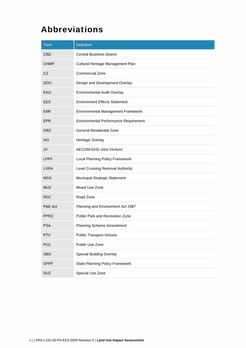
Abbreviations Term Definition
CBD Central Business District
CHMP Cultural Heritage Management Plan
CZ Commercial Zone
DDO Design and Development Overlay
EAO Environmental Audit Overlay
EES Environment Effects Statement
EMF Environmental Management Framework
EPR Environmental Performance Requirement
GRZ General Residential Zone
HO Heritage Overlay
JV AECOM-GHD Joint Venture
LPPF Local Planning Policy Framework
LXRA Level Crossing Removal Authority
MSS Municipal Strategic Statement
MUZ Mixed Use Zone
RDZ Road Zone
P&E Act Planning and Environment Act 1987
PPRZ Public Park and Recreation Zone
PSA Planning Scheme Amendment
PTV Public Transport Victoria
PUZ Public Use Zone
SBO Special Building Overlay
SPPF State Planning Policy Framework
SUZ Special Use Zone
LXRA-LX31-00-PA-EES-0005 Revision 0 | Land Use Impact Assessment | 1
1 Introduction 1.1 Purpose
The Victorian Government is removing 50 of Melbourne’s most dangerous and congested level crossings, including the level crossings at Edithvale Road, Edithvale (Edithvale) and Station Street/Bondi Road, Bonbeach (Bonbeach).
The level crossing removal projects have three core objectives. To provide:
improved productivity from more reliable and efficient transport networks
better connected, liveable and thriving communities
safer communities.
The Edithvale and Bonbeach level crossing removal projects were referred to the Minister for Planning on 9 March 2017. On 5 April 2017, the Minister issued a decision determining that an Environment Effects Statement (EES) is required for the projects due to the potential for a range of significant environmental effects.
The purpose of this report is to provide a land use impact assessment and to develop management measures for potential impacts to inform the development of a robust environmental management framework for the projects.
1.2 Why understanding land use is important
Land use impacts occur when a project has an effect on the form, function, amenity or appearance of the existing urban environment and/or the character of a place or location. Land use impacts may include:
a permanent use inconsistent with existing or future land uses or land use policies
a temporary use inconsistent with existing or future land uses or land use policies.
1.3 Project description
1.3.1 Overview
Edithvale
The Level Crossing Removal Authority (LXRA) proposes to remove the level crossing by lowering the Frankston railway line into a trench under Edithvale Road while maintaining Edithvale Road at the current road level. The trench would be located between Lochiel Avenue and Berry Avenue. It would be up to 1300 metres in length and 14 metres wide at its narrowest point, widening to up to 24 metres (including pile widths) at the new Edithvale station platforms.
The rail track would be approximately eight metres below ground level, and sit above the trench base slab and infrastructure to collect and divert rain water from the trench. The maximum depth of the excavation would be 15 metres. Pile depths would be a maximum of 24 metres at the deepest point of the trench.
Barriers, fencing and screening would be erected along the trench at road level to prevent unauthorised access by vehicles or people. Decking above the rail trench would provide for the new station building, car parking and a new substation required to ensure sufficient power is available for passenger services on the Frankston railway line. New pedestrian bridges would be constructed to retain pedestrian access across the railway line. A new station is to be constructed with lift, ramp and stair access to the below-ground train platforms.
2 | LXRA-LX31-00-PA-EES-0005 Revision 0 | Land Use Impact Assessment
Bonbeach
LXRA proposes to remove the level crossing by lowering the Frankston railway line into a trench
under Bondi Road while maintaining Bondi Road at the current road level. The trench would be
located between Golden Avenue and The Glade. It would be up to 1200 metres in length and
14 metres wide at its narrowest point, widening to up to 24 metres (including pile widths) at the
new Bonbeach station platforms.
The rail track would be approximately eight metres below ground level, and sit above the trench
base slab and infrastructure to collect and divert rain water from the trench. The maximum
depth of the excavation would be 15 metres. Pile depths would be a maximum of 24 metres at
the deepest point of the trench.
Barriers, fencing and screening would be erected along the trench at road level to prevent
access by vehicles or people. Decking above the rail trench would provide for the new station
building and car parking. New pedestrian bridges would be constructed to retain pedestrian
access across the railway line. A new station building would be constructed with lift, ramp and
stair access to the below-ground train platforms.
1.3.2 Construction
The key construction activities for the project include:
site establishment including:
o clearing of vegetation and ground levelling
o establishment of site fencing, staff facilities and temporary construction areas
protection and/or relocation of utility services
excavation for piling, foundations and the rail trench
on site waste management including removal, management and appropriate disposal of
excavated soil, rock, stormwater and groundwater
transport of spoil, excavated material and groundwater offsite
demolition of existing stations and removal of existing rail and road infrastructure
construction of bridge/deck structures to support Edithvale Road and Station Street/Bondi
Road where they cross the railway line
construction of base slab and waterproofing, including stormwater tanks
construction of new station infrastructure including platforms and buildings
construction of pedestrian overpasses and decking over the rail trench
installation and commissioning of new rail infrastructure including ballast, overhead line
equipment and rail.
Construction is expected to be completed within an 18 month period.
LXRA-LX31-00-PA-EES-0005 Revision 0 | Land Use Impact Assessment | 3
1.3.3 Operations and maintenance
Following the construction of each project, the key operation and maintenance phase activities
would include:
operation – monitoring, controlling and operation of the projects in accordance with the
rail and road network requirements
maintenance – routine inspection and monitoring of the condition of the projects, planned
routine maintenance and refurbishment work, and unplanned intervention and repair of
any assets.
Operation and maintenance activities would be undertaken by the relevant network operator
and would be consistent with existing practices and subject to the evolving operational demands
of the road and rail networks.
1.4 Project areas
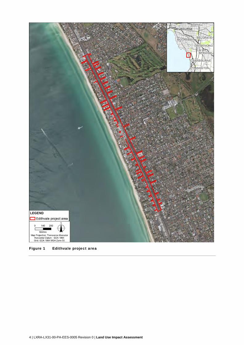
1.4.1 Edithvale
The Edithvale Road, Edithvale level crossing project area (the Edithvale project area) extends
from Lincoln Parade, Aspendale to Chelsea Road, Chelsea. It includes the rail corridor and all
of Station Street and Nepean Highway to the east and west of the rail corridor, and small
sections of adjacent road reserves. Refer to Figure 1.
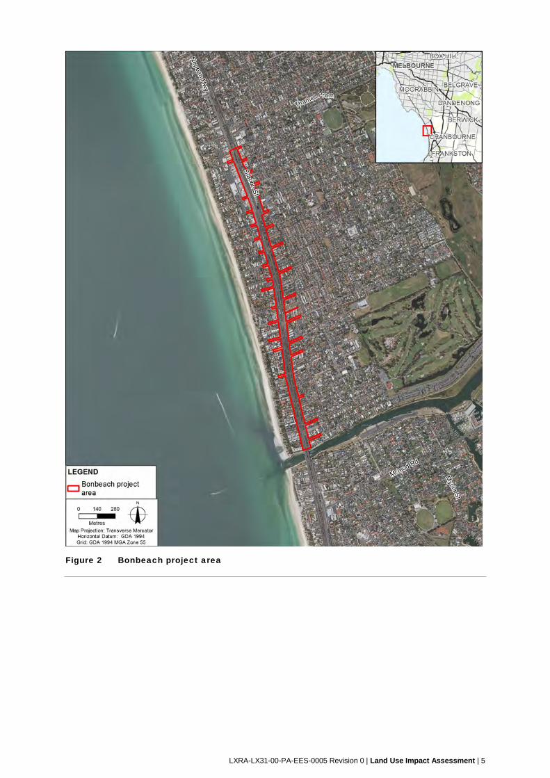
1.4.2 Bonbeach
The Station Street/Bondi Road, Bonbeach level crossing removal project area (the Bonbeach
project area) extends from Chelsea Road, Chelsea to Patterson River, Bonbeach. It includes
the rail corridor and all of Station Street and Nepean Highway located to the east and west of
the rail corridor, and small sections of adjacent road reserves. Refer to Figure 2.
1.4.3 Temporary construction areas
Specific and temporary construction areas are likely to be required however are still being
explored with relevant parties.
These areas would be used for site offices, storing materials, plant and equipment, parking for
construction works and construction traffic standby.
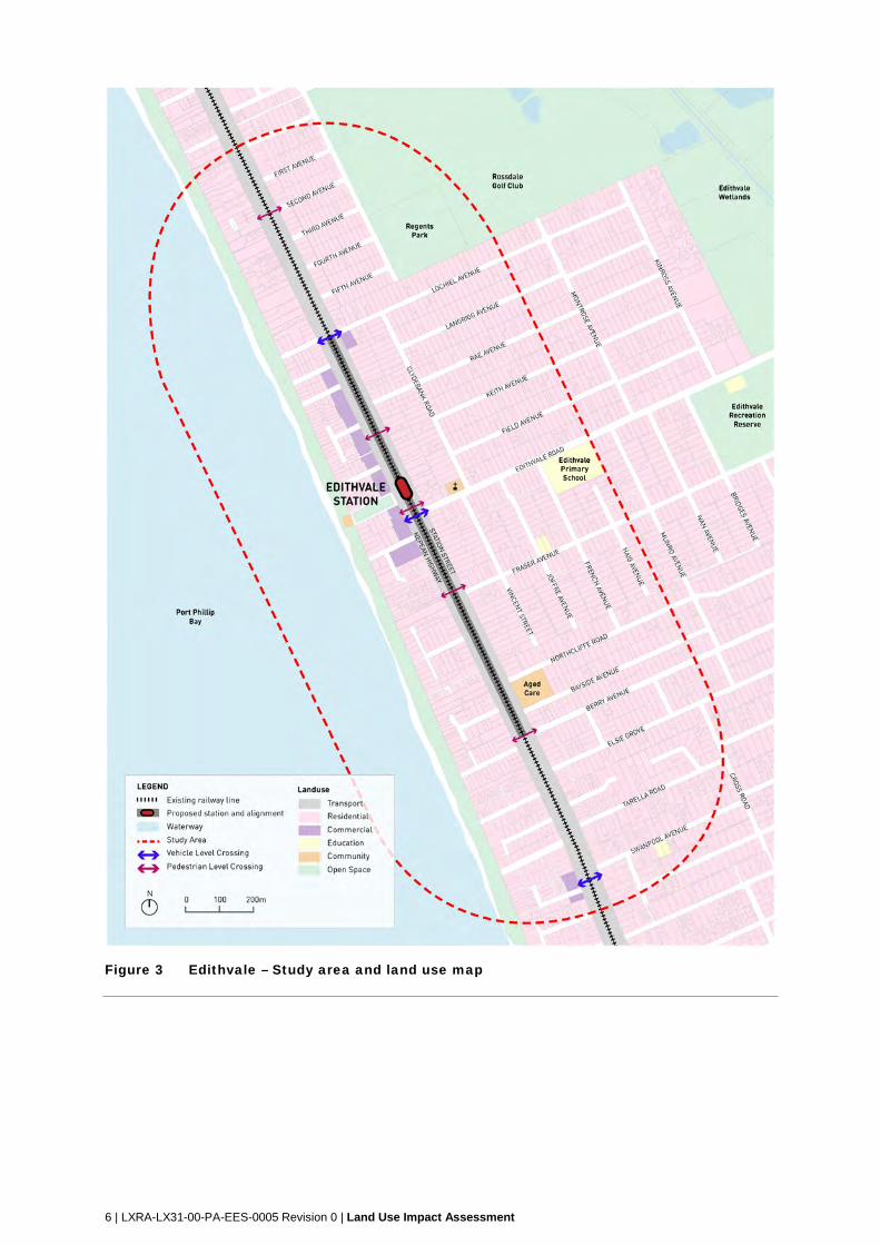
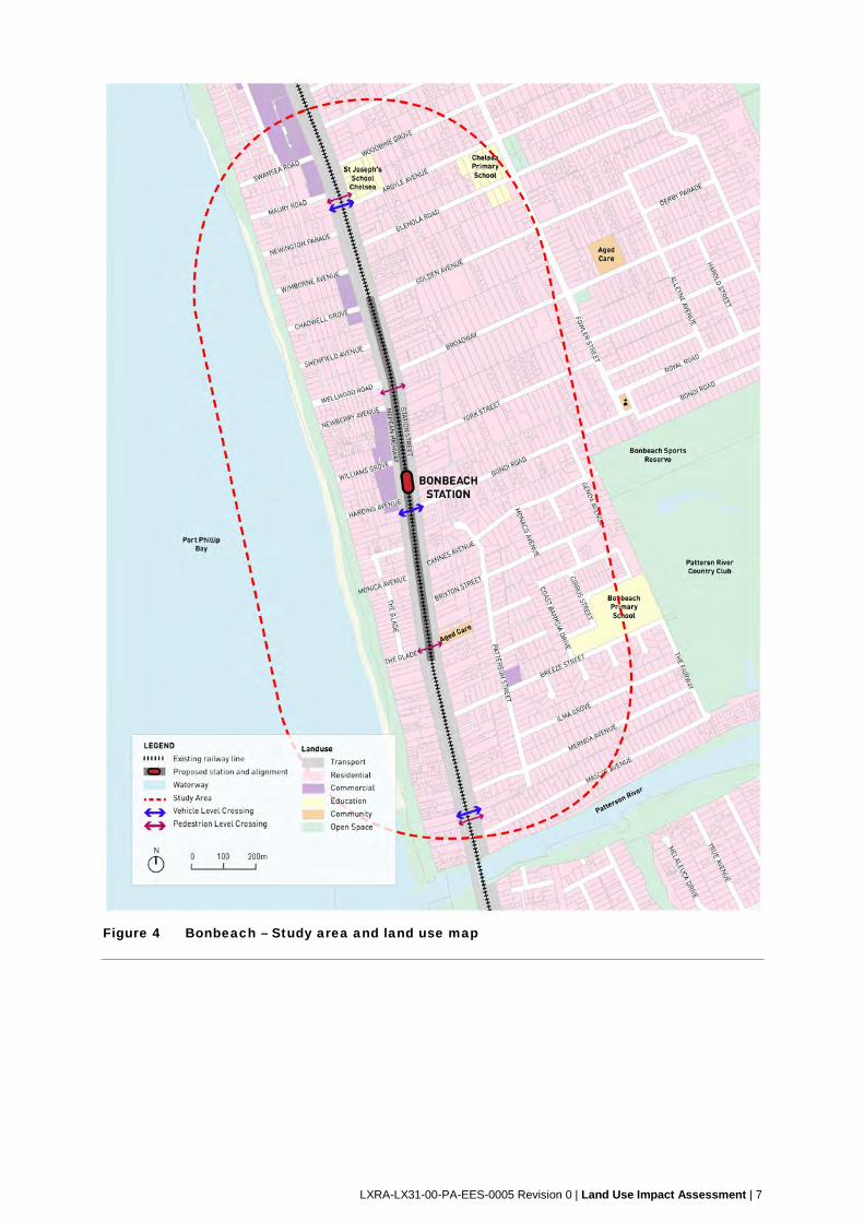
1.4.4 Study area
For the purpose of this assessment, study areas were defined as land within 500 metres of the
limit of major civil works for both the Edithvale project and the Bonbeach project, and includes:
Edithvale Study Area (refer Figure 3).
Bonbeach Study Area (refer Figure 4).
Beyond these study areas, it is anticipated that the effect of the projects on land use will be
negligible.
4 | LXRA-LX31-00-PA-EES-0005 Revision 0 | Land Use Impact Assessment
Figure 1 Edithvale project area
LXRA-LX31-00-PA-EES-0005 Revision 0 | Land Use Impact Assessment | 5
Figure 2 Bonbeach project area
6 | LXRA-LX31-00-PA-EES-0005 Revision 0 | Land Use Impact Assessment
Figure 3 Edithvale – Study area and land use map
LXRA-LX31-00-PA-EES-0005 Revision 0 | Land Use Impact Assessment | 7
Figure 4 Bonbeach – Study area and land use map
8 | LXRA-LX31-00-PA-EES-0005 Revision 0 | Land Use Impact Assessment
2 Scoping Requirements In order to meet statutory requirements, protect environmental values and sustain stakeholder
confidence, the EES would include an Environmental Management Framework (EMF). The
EMF would provide a transparent framework with clear accountabilities for managing and
monitoring environmental effects and hazards associated with the construction and operational
phases of the projects.
Section 3.3 states ‘the project description should canvass:
‘contextual information on the project, including its relationship to statutory policies, plans
and strategies; and
existing and planned land uses within and in the vicinity of the proposed project’.
Section 3.5 of the Scoping Requirements (issued September 2017), states ‘Environmental
Performance Requirements (EPRs) should be clearly described in the EMF’ and that ‘the EMF
must outline how potential adverse effects on…land uses,…open space, built form and
neighbourhood character will be avoided, minimised or mitigated’.
LXRA-LX31-00-PA-EES-0005 Revision 0 | Land Use Impact Assessment | 9
3 Legislation, policy and guidelines 3.1 Relevant legislation
Table 1 summarises the relevant primary legislation that applies to the project as well as the
implications and required approvals.
Table 1 Primary legislation and associated information
Legislation/policy Purpose Implications for this project Approvals required
State
Coastal
Management Act
1995
Establishes a framework
for the strategic
management and
planning of the Victorian
coast and coastal crown
land.
Use and development of Crown
Land within 200 metres of the
high water mark will require a
permit under the Act.
Yes
Environment
Effects Act 1978
Establishes an
administrative process
under which the Minister
for Planning may require
the proponent of a
project to prepare an
EES.
The Minister considers that the
projects 'could reasonably be
considered to have or to be
capable of having a significant
effect on the environment', and
has therefore requested that an
EES be prepared.
N/A
Major Transport
Projects
Facilitation Act
2009
Provides an assessment
framework and facilitates
the delivery of major
transport projects in
Victoria.
The Edithvale project and the
Bonbeach project have been
individually declared under the
Act, which will facilitate the
delivery of the projects.
N/A
Planning and
Environment Act
1987
Establishes the
legislative framework for
the use and
development of land in
Victoria. The Act is the
primary mechanism by
which land use and
development is
permitted, controlled or
prohibited, and it sets
out the structure and
administration of the
planning system in
Victoria.
The land in the project areas are
subject to the requirements of
the Kingston Planning Scheme.
Ordinarily, some aspects of the
use and development of the
project would require planning
permits.
The projects will be regulated by
the Act via Incorporated
Documents, which will be
inserted into the Kingston
Planning Scheme via a Planning
Scheme Amendment.
The Incorporated Documents for
each project would make the
Minister for Planning the
Responsible Authority for the
purpose of the projects, and will
allow the use and development
of the projects without needing
to seek planning permits.
Yes
10 | LXRA-LX31-00-PA-EES-0005 Revision 0 | Land Use Impact Assessment
Legislation/policy Purpose Implications for this project Approvals required
Transport
Integration Act
2010
Provides a legislative
framework for transport in
Victoria. The Act seeks to
integrate land use and
transport planning and
decision-making by
applying the framework to
land use agencies whose
decisions can significantly
impact on transport.
The Act requires
agencies, including the
Department of Economic
Development, Jobs,
Transport and Resources
and planning authorities,
to consider the potential
impact of land use
planning proposals on
transport.
The Act sets out the objectives
and principles for decision
making where proposals are
likely to significantly impact
transport. These objectives and
principles include integrated
decision making, transparency,
the precautionary principle and
consideration of the transport
system user perspective.
The projects address the key
transport system objectives and
decision making principles and
will have a positive impact on the
transport system.
No
3.2 Planning schemes
The Planning and Environment Act 1987 (P&E Act) is the primary legislative framework for the
regulation of land use and development in Victoria.
The P&E Act provides the framework for planning schemes, which contain State and Local
Government policy together with a suite of zone, overlay and particular provisions that apply to
each municipal area in Victoria. The projects are affected by the provisions of the Kingston
Planning Scheme (the Scheme) which controls the use and development of land within the
municipality. Relevant sections of the Scheme are identified below.
3.2.1 State Planning Policy Framework
The State Planning Policy Framework (SPPF) seeks to ensure that planning decisions in Victoria
are consistent with, and are supported by, the objectives of planning in Victoria as set out in
Section 4 of the P&E Act. The SPPF sets out Victorian State policy which needs to be
considered by all planning authorities, and are fostered through appropriate land use and
development planning policies and provides a context for spatial planning and decision making in
Victoria.
Policies contained within the SPPF apply to all land in Victoria and must be taken into account by planning authorities when preparing planning scheme amendments, or considering applications to use and develop land. Key State policy areas applicable to the projects include:
Clause 11 – Settlement
Clause 12 – Environment and landscape values
Clause 13 – Environmental risks
Clause 14 – Natural resource management
Clause 15 – Built environment and heritage
Clause 18 – Transport.
LXRA-LX31-00-PA-EES-0005 Revision 0 | Land Use Impact Assessment | 11
A summary of the relevant policies is provided below.
3.2.1.1 Clause 11 – Settlement
Clause 11 (Settlement) recognises that the role of planning is to anticipate and respond to the needs
of existing and future communities through the provision of zoned and serviced land for housing,
employment, recreation and open space, commercial and community facilities and infrastructure
and, as far as practicable, contribute towards liveability, accessibility, safety, economic viability and
the integration of land use and transport. Planning should also facilitate sustainable development
that takes full advantage of existing settlement patterns, activity centres and investment in transport.
Clause 11.06 (Metropolitan Melbourne) policy guidelines stipulates that in considering the policy
objectives and strategies for metropolitan Melbourne, planning must consider Plan Melbourne
2017-2050: Metropolitan Planning Strategy.
3.2.1.2 Clause 12 – Environmental and Landscape Values
Clause 12 (Environmental and Landscape Values) recognises that planning should help to
protect the health of ecological systems and the biodiversity they support and conserve areas
with identified environmental and landscape values. Planning must implement the
environmental principles of ecologically sustainable development and should protect sites and
features of nature conservation, biodiversity, geological or landscape value. Planning must
consider and properly manage impacts on and the potential removal of native vegetation, and
sites of particular environmental significance (e.g. Ramsar wetlands).
3.2.1.3 Clause 13 – Environmental Risks
Clause 13 (Environmental Risks) recognises that planning should adopt a best practice
environmental management and risk management approach which aims to avoid or minimise
environmental degradation and hazards. Planning should identify and manage the potential for the
environment, an environmental changes, to impact upon the economic, environmental or social
well-being of society. This includes floodplain management, noise abatement and air quality.
3.2.1.4 Clause 15 – Built Environment and Heritage
Clause 15 (Built Environment and Heritage) recognises that planning should ensure all new
land use and development appropriately responds to its landscape, valued built form and
cultural context, and protect places and sites with significant heritage, architectural, aesthetic,
scientific and cultural value. This includes matters of safety, functionality, urban character,
sustainability, heritage and Aboriginal cultural heritage.
3.2.1.5 Clause 18 – Transport
Clause 18 (Transport) recognises that planning should ensure an integrated and sustainable
transport system that provides access to social and economic opportunities, facilitates
economic prosperity, contributes to environmental sustainability, coordinates reliable and
efficient movements of people and goods, and is safe.
3.2.2 Local Planning Policy Framework
The Local Planning Policy Framework (LPPF) of the Scheme provides the local context and
planning policies specific to the City of Kingston, and is comprised of two components, the
Municipal Strategic Statement (MSS) and local planning policies. The MSS provides the
context, policies and strategic basis for the application of planning controls (for example, zones
and overlays) and the local policies provide policy statements of intent or expectation for an
area outlines how land use and development within the municipality of the City of Kingston are
to be considered.
The following clauses within the LPPF for the City of Kingston are relevant to the projects.
12 | LXRA-LX31-00-PA-EES-0005 Revision 0 | Land Use Impact Assessment
3.2.2.1 Land use
Clause 21 (MSS) seeks to provide a clear vision and direction for what land use planning
should achieve in the City of Kingston.
Clause 21.03 (Land Use Challenges for the New Millennium) recognises key land use
issues which are likely to challenge Kingston’s future growth and development, including
protecting and enhancing ecological values.
Clause 21.04 (Vision) recognises that Kingston’s vision for future land use planning and
development is expressed around a number of key land use themes, including:
o retail and commercial land use
o environment, wetlands and waterways
o transport, movement and access
o heritage.
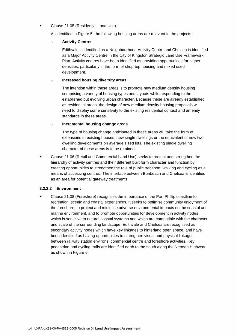
The Strategic Land Use Framework Plan (Figure 5) identifies the areas surrounding the projects
as areas of incremental and increased housing diversity within a foreshore/residential environs
area. Chelsea is identified as areas for promotion of residential renewal and increased housing
diversity.
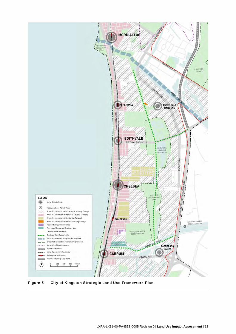
LXRA-LX31-00-PA-EES-0005 Revision 0 | Land Use Impact Assessment | 13
Figure 5 City of Kingston Strategic Land Use Framework Plan
14 | LXRA-LX31-00-PA-EES-0005 Revision 0 | Land Use Impact Assessment
Clause 21.05 (Residential Land Use)
As identified in Figure 5, the following housing areas are relevant to the projects:
o Activity Centres
Edithvale is identified as a Neighbourhood Activity Centre and Chelsea is identified
as a Major Activity Centre in the City of Kingston Strategic Land Use Framework
Plan. Activity centres have been identified as providing opportunities for higher
densities, particularly in the form of shop-top housing and mixed used
development.
o Increased housing diversity areas
The intention within these areas is to promote new medium density housing
comprising a variety of housing types and layouts while responding to the
established but evolving urban character. Because these are already established
as residential areas, the design of new medium density housing proposals will
need to display some sensitivity to the existing residential context and amenity
standards in these areas.
o Incremental housing change areas
The type of housing change anticipated in these areas will take the form of
extensions to existing houses, new single dwellings or the equivalent of new two
dwelling developments on average sized lots. The existing single dwelling
character of these areas is to be retained.
Clause 21.06 (Retail and Commercial Land Use) seeks to protect and strengthen the
hierarchy of activity centres and their different built form character and function by
creating opportunities to strengthen the role of public transport, walking and cycling as a
means of accessing centres. The interface between Bonbeach and Chelsea is identified
as an area for potential gateway treatments.
3.2.2.2 Environment
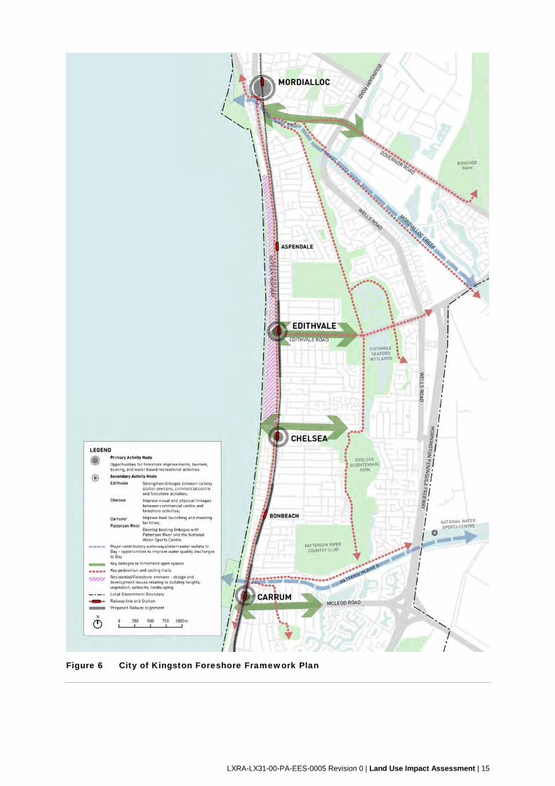
Clause 21.08 (Foreshore) recognises the importance of the Port Phillip coastline to
recreation, scenic and coastal experiences. It seeks to optimise community enjoyment of
the foreshore, to protect and minimise adverse environmental impacts on the coastal and
marine environment, and to promote opportunities for development in activity nodes
which is sensitive to natural coastal systems and which are compatible with the character
and scale of the surrounding landscape. Edithvale and Chelsea are recognised as
secondary activity nodes which have key linkages to hinterland open space, and have
been identified as having opportunities to strengthen visual and physical linkages
between railway station environs, commercial centre and foreshore activities. Key
pedestrian and cycling trails are identified north to the south along the Nepean Highway
as shown in Figure 6.
LXRA-LX31-00-PA-EES-0005 Revision 0 | Land Use Impact Assessment | 15
Figure 6 City of Kingston Foreshore Framework Plan
16 | LXRA-LX31-00-PA-EES-0005 Revision 0 | Land Use Impact Assessment
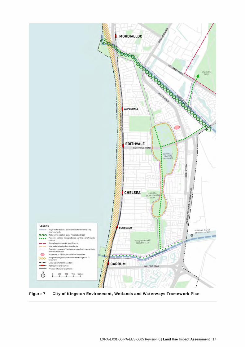
Clause 21.09 (Environment Wetlands and Waterways) acknowledges that the
environmental landscape of the City of Kingston is recognised for its diversity and
significance in both a local and regional context, and specifically seeks to protect the
physical and habitat diversity of the Edithvale-Seaford wetlands to recognise its role as
an internationally significant wetland area and to maintain the diversity of flora and fauna
habitats within Kingston. The Environment, Wetlands and Waterways Framework Plan
(Figure 7) identifies the Edithvale-Seaford Wetlands as a site of identified environmental
significance and identifies the foreshore between the Nepean Highway and Port Phillip
Bay as an area for indigenous vegetation enhancement adjacent to the foreshore. The
Patterson River is identified as an area for the potential creation of habitat corridors,
improvements to natural landscapes and the protection of significant remnant vegetation.
3.2.2.3 Transport
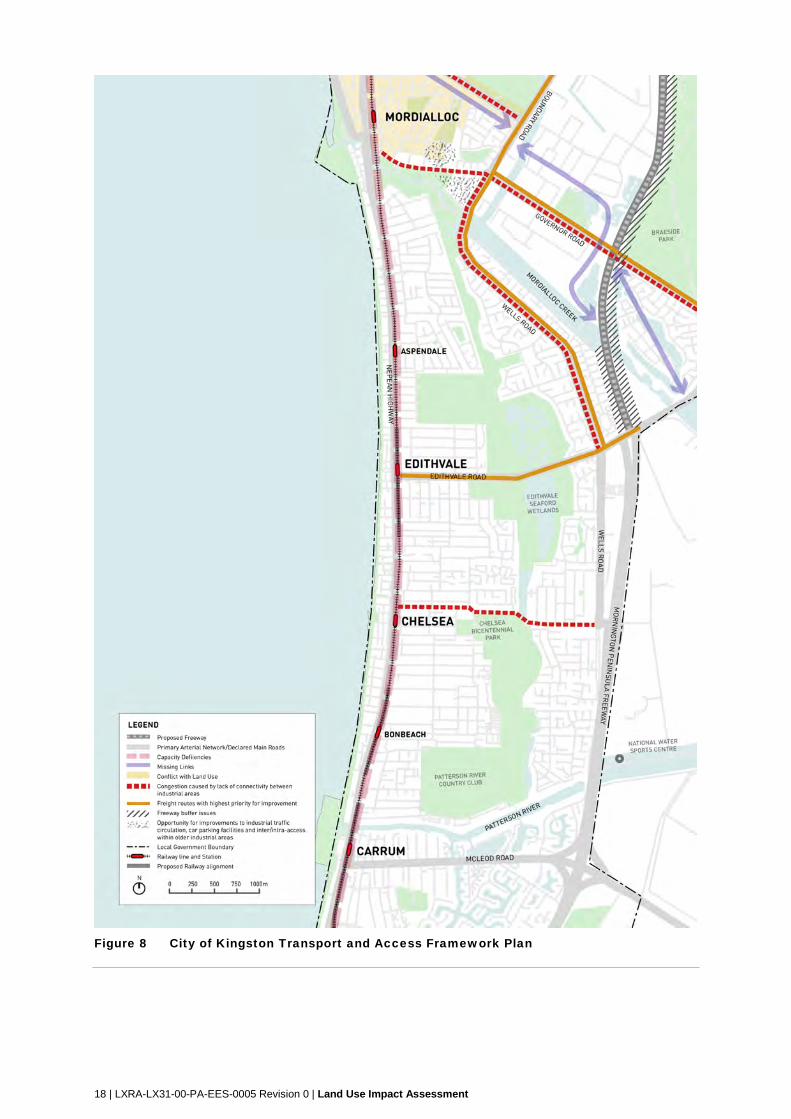
Clause 21.12 (Transport, Movement and Access) recognises the importance of a
balanced transport network based on public transport, road, pedestrian and cycle
systems in providing access for people to jobs and services, and goods to market. The
Transport and Access Framework Plan (Figure 8) identifies Edithvale Road as a freight
capacity route with highest priority for improvement and the Nepean Highway as a
Declared Main Road with capacity deficiencies.
3.2.2.4 Built environment and heritage
Clause 21.13 (Heritage) recognises the wide ranging heritage assets found within
Kingston and seeks to identify, protect and enhance places of cultural heritage value.
Clause 22.16 (Heritage Policy) seeks to identify, protect, conserve and manage places or
elements of cultural heritage significance within Kingston.
LXRA-LX31-00-PA-EES-0005 Revision 0 | Land Use Impact Assessment | 17
Figure 7 City of Kingston Environment, Wetlands and Waterways Framework Plan
18 | LXRA-LX31-00-PA-EES-0005 Revision 0 | Land Use Impact Assessment
Figure 8 City of Kingston Transport and Access Framework Plan
LXRA-LX31-00-PA-EES-0005 Revision 0 | Land Use Impact Assessment | 19
3.2.3 Planning approval
The P&E Act establishes a framework for the use, development and conservation of land in
Victoria. This Act provides for the preparation and administration of planning schemes which
control the use and development of land, and the process of considering land use and
development proposals.
It is envisioned that the development and use of land for both the Edithvale project and
Bonbeach project would be facilitated by separate Incorporated Documents within the Scheme.
The Incorporated Document for each project would be inserted into the Scheme by the Minister
for Planning via separate Planning Scheme Amendments (PSAs).
The effect of the Incorporated Documents would be to remove the requirement for the projects
to seek planning permits, subject to various requirements, including matters to be undertaken to
the satisfaction of either the Minister for Planning or other approving authorities, contained
within the relevant Incorporated Document.
Draft PSAs will be exhibited with the EES to allow the community to provide submissions and
feedback. The Minister's assessment of the EES report will inform the consideration of the
PSAs.
3.2.4 Land use definitions
The projects are comprised of a number of land use and development components, some of
which ordinarily would require a planning permit under the Scheme.
The activities included in the projects are defined as ‘Minor Utility Installation’, ‘Railway’,
‘Railway Station’ and ‘Road.’ The following land use definitions are relevant to the projects:
Minor Utility Installation is a land use defined in the Scheme as ‘land used for a utility
installation comprising any of the following: a) sewerage or water mains; b) storm or flood water
drains or retarding basins; d) gas mains providing gas directly to consumers; e) power lines
designed to operate at less than 220,000 volts; f) a sewage treatment plant, and any associated
disposal works, required to serve a neighbourhood; g) a pumping station required to serve a
neighbourhood; or h) an electrical sub-station designed to operate at no more than 66,000 volts.
It includes any associated flow measurement device or a structure to gauge waterway flow.’
Railway is a land use that is not defined in the Scheme, the P&E Act or the Interpretation of
Legislation Act 1984, accordingly, the term has its ordinary meaning.
Dictionary definitions of ‘Railway’ include associated infrastructure (e.g. ‘the entire equipment,
rolling stock, buildings, property, and system of tracks’).
The meaning of railway and rail infrastructure in the Rail Management Act 1996 provides some
guidance as it includes ‘railway track, railway track sidings, associated track structures and
works (such as cuttings, tunnels, bridges, stations, platforms, excavations, land fill, track support
earthworks and drainage works), over-track structures, under-track structures, service roads,
signalling systems, rolling stock control systems, communications systems, notices and signs,
overhead electrical power supply systems and associated buildings, depots, yards, plant,
machinery and equipment.’
Railway Station is a land use defined in the Scheme as ‘land used to assemble and distribute
goods or passengers and includes facilities to park and manoeuvre vehicles. It may include the
selling of good, drinks and other convenience goods and services.’
Road is a land use defined in the P&E Act and includes ‘highway, street, lane, footway, square,
court, alley or right of way, whether a thoroughfare or not and whether accessible to the public
generally or not.’
20 | LXRA-LX31-00-PA-EES-0005 Revision 0 | Land Use Impact Assessment
3.2.5 Planning zones
The project areas encompass a range of zones as shown in the project area zoning maps at
Appendix A. An analysis of the zoning requirements are found in Sections 3.2.7 and 3.2.8 of this
report.
As identified in these sections, the projects require a number of planning approvals.
3.2.6 Planning overlays
The project areas encompass a range of overlays as shown in the project area overlay maps at
Appendix B. An analysis of the overlay requirements are found in Sections 3.2.7 and 3.2.8.
As identified in these sections, the projects require a number of planning approvals.
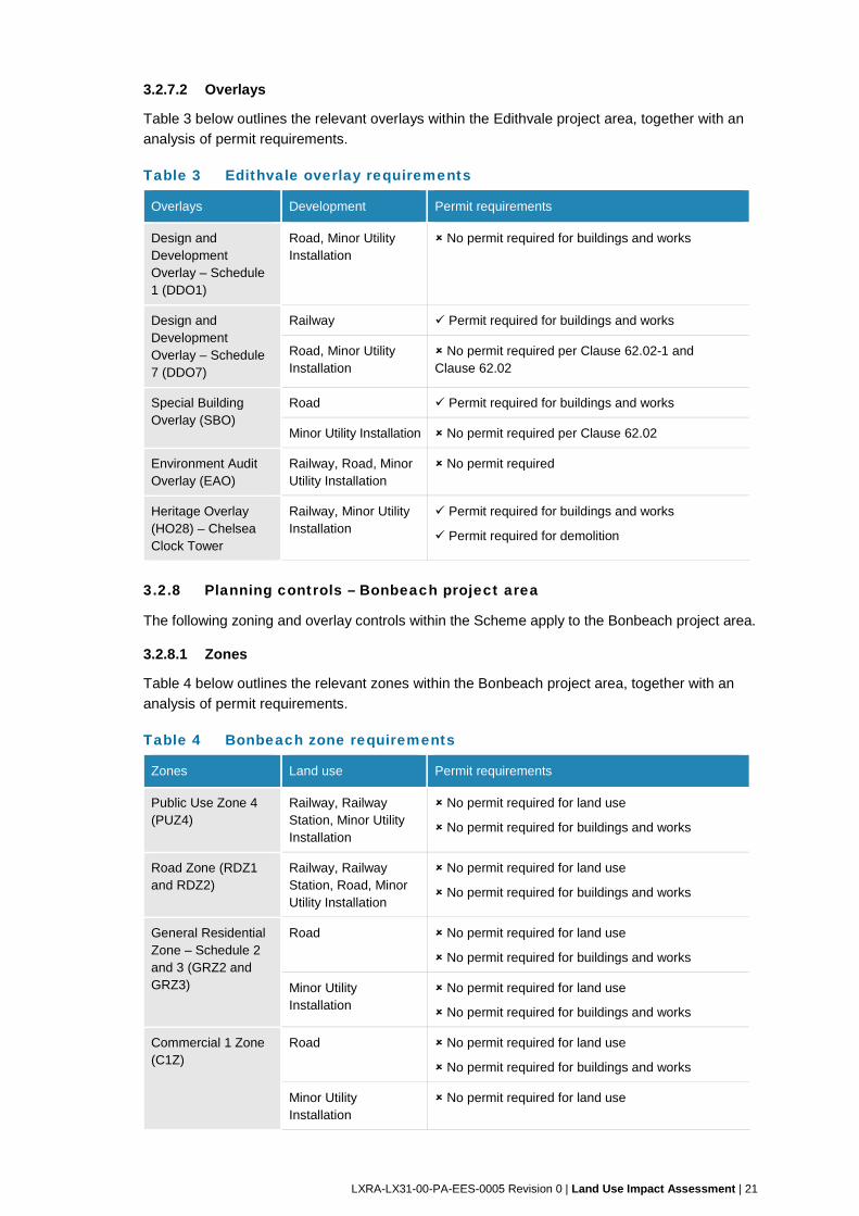
3.2.7 Planning controls – Edithvale project area
The following zone and overlay controls within the Scheme apply to the Edithvale project area.
3.2.7.1 Zones
Table 2 below outlines the relevant zones within the Edithvale project area, together with an
analysis of permit requirements.
Table 2 Edithvale zone requirements
Zone Land use Permit requirements
Public Use Zone 4
(PUZ4)
Railway, Railway
Station, Road, Minor
Utility Installation
No permit required for land use
No permit required for buildings and works
Road Zone (RDZ1
and RDZ2)
Railway, Road, Minor
Utility Installation
No permit required for land use
No permit required for buildings and works
General Residential
Zone – Schedule 2
and 3 (GRZ2 and
GRZ3)
Road No permit required for land use
No permit required for buildings and works
Minor Utility
Installation
No permit required for land use
No permit required for buildings and works
Commercial 1 Zone
(C1Z)
Road No permit required for land use
No permit required for buildings and works
Minor Utility
Installation
No permit required for land use
Buildings and works exempt per cl. 62.02-1
Mixed Use Zone
(MUZ)
Road No permit required for land use
No permit required for buildings and works
Minor Utility
Installation
No permit required for land use
No permit required for buildings and works
LXRA-LX31-00-PA-EES-0005 Revision 0 | Land Use Impact Assessment | 21
3.2.7.2 Overlays
Table 3 below outlines the relevant overlays within the Edithvale project area, together with an
analysis of permit requirements.
Table 3 Edithvale overlay requirements
Overlays Development Permit requirements
Design and Development Overlay – Schedule 1 (DDO1)
Road, Minor Utility Installation
No permit required for buildings and works
Design and Development Overlay – Schedule 7 (DDO7)
Railway Permit required for buildings and works
Road, Minor Utility Installation
No permit required per Clause 62.02-1 and Clause 62.02
Special Building Overlay (SBO)
Road Permit required for buildings and works
Minor Utility Installation No permit required per Clause 62.02
Environment Audit Overlay (EAO)
Railway, Road, Minor Utility Installation
No permit required
Heritage Overlay (HO28) – Chelsea Clock Tower
Railway, Minor Utility Installation
Permit required for buildings and works
Permit required for demolition
3.2.8 Planning controls – Bonbeach project area
The following zoning and overlay controls within the Scheme apply to the Bonbeach project area.
3.2.8.1 Zones
Table 4 below outlines the relevant zones within the Bonbeach project area, together with an
analysis of permit requirements.
Table 4 Bonbeach zone requirements
Zones Land use Permit requirements
Public Use Zone 4 (PUZ4)
Railway, Railway Station, Minor Utility Installation
No permit required for land use
No permit required for buildings and works
Road Zone (RDZ1 and RDZ2)
Railway, Railway Station, Road, Minor Utility Installation
No permit required for land use
No permit required for buildings and works
General Residential Zone – Schedule 2 and 3 (GRZ2 and GRZ3)
Road No permit required for land use
No permit required for buildings and works
Minor Utility Installation
No permit required for land use
No permit required for buildings and works
Commercial 1 Zone (C1Z)
Road No permit required for land use
No permit required for buildings and works
Minor Utility Installation
No permit required for land use
22 | LXRA-LX31-00-PA-EES-0005 Revision 0 | Land Use Impact Assessment
Zones Land use Permit requirements
Buildings and works exempt per cl. 62.02-1
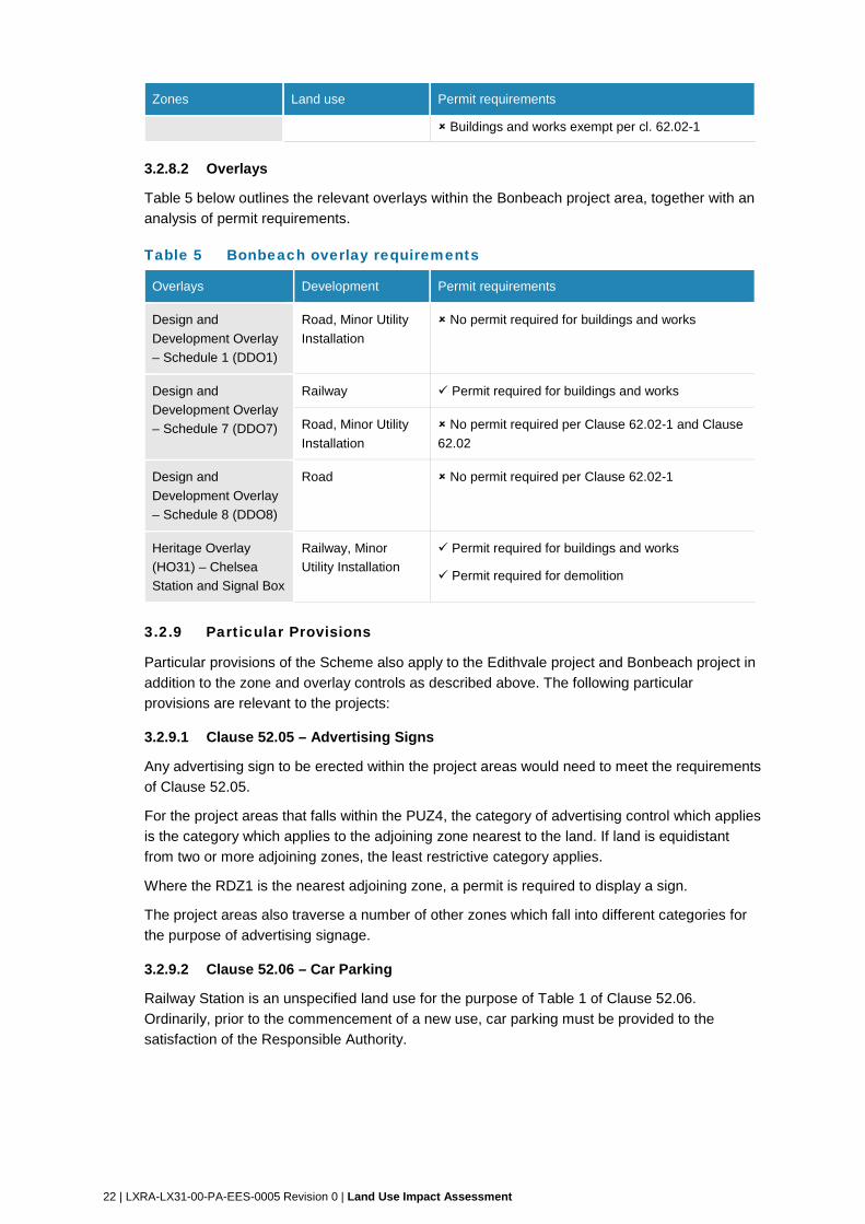
3.2.8.2 Overlays
Table 5 below outlines the relevant overlays within the Bonbeach project area, together with an
analysis of permit requirements.
Table 5 Bonbeach overlay requirements
Overlays Development Permit requirements
Design and
Development Overlay
– Schedule 1 (DDO1)
Road, Minor Utility
Installation
No permit required for buildings and works
Design and
Development Overlay
– Schedule 7 (DDO7)
Railway Permit required for buildings and works
Road, Minor Utility
Installation
No permit required per Clause 62.02-1 and Clause
62.02
Design and
Development Overlay
– Schedule 8 (DDO8)
Road No permit required per Clause 62.02-1
Heritage Overlay
(HO31) – Chelsea
Station and Signal Box
Railway, Minor
Utility Installation
Permit required for buildings and works
Permit required for demolition
3.2.9 Particular Provisions
Particular provisions of the Scheme also apply to the Edithvale project and Bonbeach project in
addition to the zone and overlay controls as described above. The following particular
provisions are relevant to the projects:
3.2.9.1 Clause 52.05 – Advertising Signs
Any advertising sign to be erected within the project areas would need to meet the requirements
of Clause 52.05.
For the project areas that falls within the PUZ4, the category of advertising control which applies
is the category which applies to the adjoining zone nearest to the land. If land is equidistant
from two or more adjoining zones, the least restrictive category applies.
Where the RDZ1 is the nearest adjoining zone, a permit is required to display a sign.
The project areas also traverse a number of other zones which fall into different categories for
the purpose of advertising signage.
3.2.9.2 Clause 52.06 – Car Parking
Railway Station is an unspecified land use for the purpose of Table 1 of Clause 52.06.
Ordinarily, prior to the commencement of a new use, car parking must be provided to the
satisfaction of the Responsible Authority.
LXRA-LX31-00-PA-EES-0005 Revision 0 | Land Use Impact Assessment | 23
3.2.9.3 Clause 52.17 – Native Vegetation
A permit is required to remove, destroy or lop native vegetation, including dead native
vegetation. An application to remove, destroy or lop native vegetation must be classified as one
of the following risk-based pathways: low, moderate or high, as defined in the Permitted clearing
of native vegetation - Biodiversity assessment guidelines. This does not apply:
if the table to Clause 52.17-7 specifically states that a permit is not required
to the removal, destruction or lopping of native vegetation specified in the schedule to this
clause
to an area specified in the schedule to this clause.
3.2.9.4 Clause 52.29 – Land Adjacent to a Road Zone Category 1, or a Public Acquisition Overlay for a Category 1 Road
The project area includes various roads zoned RDZ1. Where the project proposes the creation
or alteration of access to a RDZ1, a planning permit would ordinarily be required for the creation
and alteration of access pursuant to Clause 52.29 and would ordinarily be referred to the Roads
Corporation (VicRoads) as a determining Referral Authority.
3.2.9.5 Clause 52.36 – Integrated Public Transport Planning
A planning permit application must be referred to Public Transport Victoria (PTV) for comment if
the proposal includes any alteration or development of public transport infrastructure.
The projects involve the alteration and development of public transport infrastructure and would
ordinarily be referred to PTV.
3.3 Planning scheme amendments
The Scheme is able to be amended by way of a Planning Scheme Amendment (PSA).
A Scheme can only be changed with the approval of the Minister for Planning.
Relevant PSAs that may impact on the projects have been identified and the impact discussed
below.
3.3.1 Recent amendments to the Scheme
3.3.1.1 Amendment C147 – Rossdale Golf Course (part)
This amendment rezoned a small portion of land at the south eastern corner of that site from a
Special Use Zone 1 – Golf Course to a General Residential 3 Zone to allow for residential use.
The Amendment also applied an Environmental Audit Overlay to the subject land.
Concurrent to the amendment was a planning permit application (permit application number
KP15/480) for the subdivision of the land into two lots and the removal of native vegetation.
This amendment reflects a small change in land use within the study area from recreation to
residential. The amendment was gazetted on 24 January 2017 and forms part of the Scheme.
24 | LXRA-LX31-00-PA-EES-0005 Revision 0 | Land Use Impact Assessment
3.3.2 Proposed amendments to the Scheme
3.3.2.1 Amendment C132 – Implementation of part of the recommendation of the Kingston Planning Scheme Review 2012
Amendment C132 seeks to replace the existing Municipal Strategic Statement (MSS) at Clause
21 of the Scheme with a new format MSS and seeks to amend Clause 22 of the LPPF, in
accordance with part of the recommendations of the Kingston Planning Scheme Review 2012.
The proposed changes are generally policy neutral and relate to the removal, rewording and
revising of existing content.
Clause 21 of the Scheme will be updated to draw upon and provide consistency with the SPPF.
Additionally, the MSS and LPPF will be updated to remove redundant references currently in
the Scheme, including the removal of Clause 22.02 (Springvale Industrial Park Area Policy),
Clause 22.06 (South Road Industrial Gateway) and Clause 22.08 (Park View Industrial Estate).
The proposed Amendment also updates policy references, overviews, data and content within
the LPPF that have been identified in the Kingston Planning Scheme Review 2012 as requiring
revision or removal. These changes have been made to ensure that the Scheme is clearly
worded and concise and will reflect the most up to date statistics for the municipality.
Clause 21.12 (Transport Movement and Access) is relevant to the project and proposed to be
deleted from the Scheme by Amendment C132.
The changes proposed by Amendment C132 do not materially change the analysis of the
relevant local policy framework as set out in 3.2.2 of this report.
Amendment C132 has been adopted by Council and was submitted to the Minister for Planning
for approval on 28 July 2017.
LXRA-LX31-00-PA-EES-0005 Revision 0 | Land Use Impact Assessment | 25
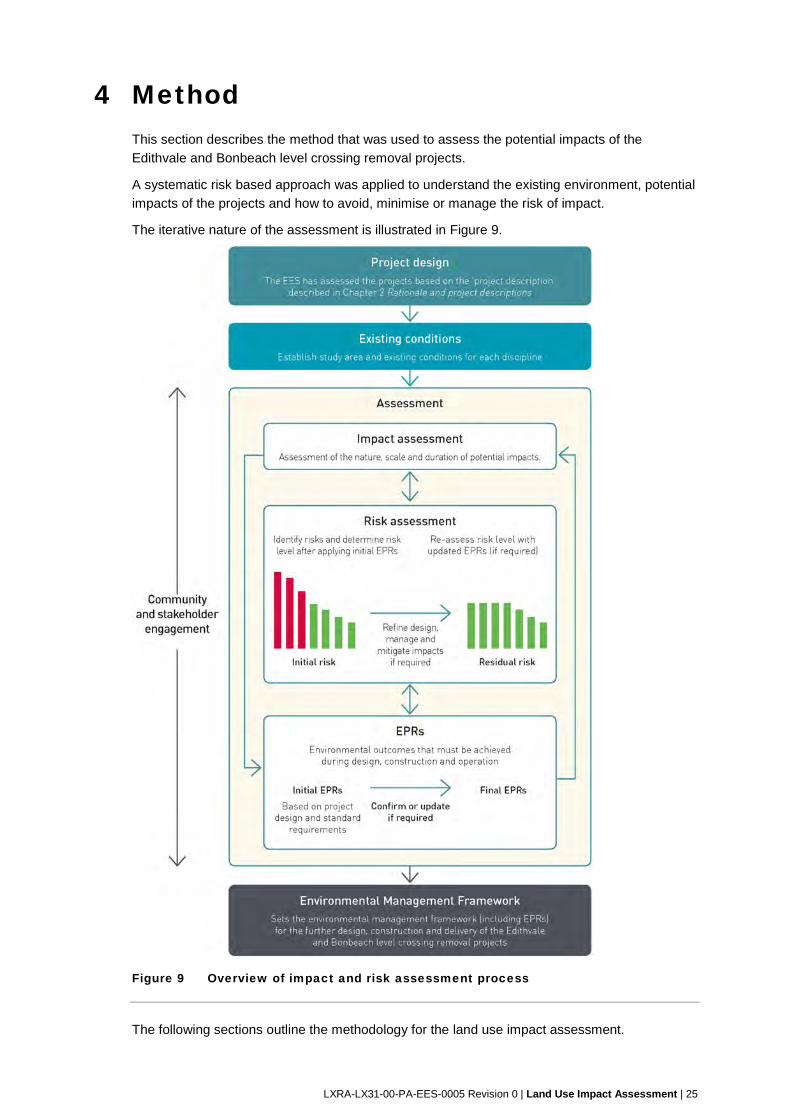
4 Method This section describes the method that was used to assess the potential impacts of the
Edithvale and Bonbeach level crossing removal projects.
A systematic risk based approach was applied to understand the existing environment, potential
impacts of the projects and how to avoid, minimise or manage the risk of impact.
The iterative nature of the assessment is illustrated in Figure 9.
Figure 9 Overview of impact and risk assessment process
The following sections outline the methodology for the land use impact assessment.
26 | LXRA-LX31-00-PA-EES-0005 Revision 0 | Land Use Impact Assessment
4.1 Existing conditions assessment
This existing conditions assessment sets a baseline of current land use within the study areas,
and provides for the assessment of any potential impacts of the projects to land use.
4.1.1 Establish existing conditions
The study areas (refer to Figure 3 and Figure 4) include a summary of existing conditions. The
purpose of the existing conditions review is to identify and describe current land uses in and
around the study areas.
4.1.2 Desktop assessment and baseline data review
A detailed desktop assessment was undertaken drawing from various publicly available state
and local government reports and literature, land use planning databases to understand the
existing conditions within the study areas. The following baseline data was reviewed as part of
the desktop assessment:
the legislative framework which applies to land contained in and around the study area,
including:
o Plan Melbourne 2017-2050.
o State and local government strategic planning policy to identify where the proposed
works would impact on strategic plans and land use plans identified by the City of
Kingston.
the Scheme, and particularly:
o the SPPF and LPPF.
o zones, overlays and relevant particular provisions.
current strategic planning work and future PSA amendments being considered by the
State and the City of Kingston.
publicly accessible aerial imagery.
4.1.3 Site visit and consultation
In addition, the following activities were undertaken:
site visits were conducted on 28 June 2017 and 29 August 2017 to observe and identify
existing and proposed land uses and development within the Study Areas. The site visit
was conducted on foot and by car.
consultation with relevant State and local government agencies was also undertaken for
this assessment. The outcomes of this consultation informed the assessment of existing
and likely future land use in the study areas.
LXRA-LX31-00-PA-EES-0005 Revision 0 | Land Use Impact Assessment | 27
4.2 Risk assessment
A risk-based approach is integral to the EES as required by Section 3 of the Scoping
Requirements for the EES.
The risk management approach adopted for the Edithvale and Bonbeach EES is consistent with
AS/NZS ISO 31000:2009 Risk Management Process and involves the following steps:
establishment of the context of the risk assessment – this identifies the boundaries of the
projects including the project definition, the duration of construction and operation, the
design and environmental controls that would be in place (initial Environmental
Performance Requirements (EPRs) – refer to Section 8), and the location of the projects
risk identification – identification of risk pathways by specialists in each relevant discipline
area
risk analysis – assessment of risk for each risk pathway, whereby risk is a combination of:
o the likelihood of an event and its associated consequences occurring
o the magnitude of potential consequences of the event.
risk evaluation – review key risks posed by the projects to focus effort in terms of impact
assessment and mitigation.
risk treatment – identification of additional management and mitigation where required to
reduce risk levels where possible.
An initial risk assessment was undertaken to assess potential risks to the environment arising
from the implementation of the projects. Where risks were minor or above, further mitigation was
explored. Risks were re-assessed to determine the residual risk based on further mitigation.
A more detailed description of each step in the risk assessment process is provided in EES
Attachment II Environmental Risk Report.
This technical report describes the risks associated with the projects on land use.
4.3 Impact assessment
The impact assessment has assessed the planned (known) land use impacts and the risk of
additional (uncertain) land use impacts that the projects would or may have on land use within
the study areas.
In order to provide an assessment of the potential impact of the projects on the land use within
the study areas, the following tasks have been undertaken:
assessment of the potential implications for existing and likely future land uses, as a
result of the projects, including consideration of:
o land use requirements during the construction of the projects
o land use requirements during the operation of the projects
o consistency with existing or future land use policy and planning framework (such
as zonings, overlays or structure plans)
o potential constraints on or changes to existing or likely future land use on adjacent
sites
o amenity impacts of the construction or operation of the projects where they relate
to land use
identification of measures to avoid or manage potential impacts on land use.
28 | LXRA-LX31-00-PA-EES-0005 Revision 0 | Land Use Impact Assessment
4.4 Environmental Performance Requirements
The environmental outcomes that must be achieved during design, construction and operation
of the projects are referred to throughout the EES as Environmental Performance Requirements
(EPRs). EPRs must be achieved regardless of the construction methodology or design solutions
adopted. Measures identified in this EES to avoid or minimise environmental impacts have
formed part of the recommended EPRs for the projects.
The development of a final set of EPRs for the project has been iterative.
4.4.1 Initial EPRs
Environmental performance requirements were identified to inform the assessment of initial risk
ratings (where appropriate). These initial EPRs were based on compliance with legislation and
standard requirements that are typically incorporated into the delivery of construction contracts
for rail projects.
4.4.2 Confirm or update EPRs
The risk assessment either confirmed that these EPRs were adequate or identified the need for
further refinement.
EPRs were updated or new EPRs were developed for any initial risk that could not be
appropriately managed by standard requirements. The risk and impact assessment processes
confirmed the effectiveness of new or updated EPRs to determine the residual risk rating.
4.4.3 Final EPRs
The EPRs recommended for the projects are outlined in Section 8 of this report and are
included in the EES Environmental Management Framework.
The EPRs are applicable to the final design, construction approach and operation and provide
certainty regarding the environmental performance of the projects.
4.5 Linkage to other technical reports
The land use impact assessment should be read in conjunction with other relevant technical
reports forming part of the EES. Other impacts relating to amenity, noise, air quality, vibration
and visual impact have been considered in detail in other technical reports.
The outcomes of the land use impact assessment were used as inputs to:
EES Technical Report L Social
This report also considered:
EES Technical Report G Traffic
EES Technical Report H Noise and Vibration
EES Technical Report I Air Quality
EES Technical Report J Landscape and Visual
EES Technical Report K Business
EES Technical Report L Social
Where relevant to land use, other technical reports are considered and referenced.
LXRA-LX31-00-PA-EES-0005 Revision 0 | Land Use Impact Assessment | 29
5 Existing conditions 5.1 Regional Context
This section describes the existing land use within the project study area and situates this
description within a broader regional context.
5.1.1 Regional land use context
The projects are located wholly within the municipality of Kingston on the Frankston rail corridor.
The projects are located south of the suburb of Aspendale and north of the suburb of Carrum,
are separated from each other by the suburb of Chelsea. The projects are located proximate to
the Port Phillip Bay foreshore.
A description of the regional land use context for the Frankston rail corridor is as follows:
5.1.1.1 Land use
The Frankston rail corridor is a rail transport corridor which contains the Frankston rail line and
associated infrastructure. The railway provides passenger connectivity between Frankston and
the Central Business District of Melbourne. It is collocated with the Pakenham and Cranbourne
lines between Flinders Street Railway Station and Caulfield Railway Station. The Frankston rail
line then branches southwards at Caulfield Junction (located immediately to the southeast of
Caulfield Railway Station) where it continues within a separate alignment towards Frankston
Railway Station.
The rail corridor also provides for occasional rail freight movements.
Commuter access to the Frankston rail line is provided via 32 railway stations interspersed
along the rail line. The stations are located within the rail corridor and are characterised by
commuter car parking, station buildings and facilities, and a range of service levels.
Rail infrastructure to provide for the safe and efficient operation of the railway is located within
the rail corridor and includes electrical substations, signalling and power equipment, train
stabling and maintenance facilities, maintenance and rail access points, staff and driver
facilities.
The rail corridor also traverses Mordialloc Creek, Patterson River and Kananook Creek via a
series of rail bridges. The rail corridor is also traversed by a number of roads and pedestrian
and cyclist access points, which comprise the various level crossings along the Frankston rail
line.
The zoning of the rail corridor is primarily Public Use Zone 4 – Transport (PUZ4) which is
consistent with the historic and existing land use as a railway. Where the rail corridor traverses
arterial roads the corridor is zoned Road Zone Category 1 (RDZ1); where the corridor traverses
major local roads, the corridor is zoned Road Zone Category 2 (RDZ2); where the corridor
traverses the Patterson River the corridor is zoned both PUZ4 and Public Park and Recreation
Zone (PPRZ).
The rail corridor contains a variety of overlays that reflect more localised conditions and reflect,
for example, the existence of buildings of heritage value within the rail corridor, local
hydrological and cross-flow conditions, areas of environmental significance, wildfire sensitivity
and building height controls.
Land uses adjacent and proximate to the Frankston rail corridor are varied and predominantly
characterised by residential dwelling typologies and diverse retail and commercial uses. Major
activity centres located along the corridor running north to south, include Caulfield, Glenhuntly,
30 | LXRA-LX31-00-PA-EES-0005 Revision 0 | Land Use Impact Assessment
Bentleigh, Moorabbin, Southland/Cheltenham, Mentone, Mordialloc, Chelsea and Frankston. A
number of smaller Neighbourhood Activity Centres are located along the corridor and are
generally clustered around train station precincts, while further mixed use and commercial
centres are located along key arterial roads that intersect with the rail corridor.
Moorabbin Airport is located to the east of the rail corridor. The Monash and Dandenong
National Employment and Innovation Clusters are major commercial and industrial employment
nodes and are also located nearby.
The corridor traverses or runs proximate to a mix of informal public open spaces and
recreational land uses including parklands, narrow linear reserves, sport fields, playgrounds,
creek and riverine environs, golf courses, marinas, and the Port Phillip Bay and Port Phillip Bay
foreshore.
5.1.2 Relevant State policies and strategies
5.1.2.1 Plan Melbourne 2017-2050
Plan Melbourne 2017-2050 (Plan Melbourne) is a State Government policy framework that sets
out the long term strategic plan for metropolitan Melbourne. Plan Melbourne addresses some of
the fundamental challenges that the city is facing and seeks to plan for and manage
Melbourne’s future growth in population and employment.
Plan Melbourne includes seven outcomes which aim to drive Melbourne as a competitive,
liveable and sustainable city. The project is supported by, and is consistent with, Outcome 3:
Melbourne has an integrated transport system that connects people to jobs and services and
goods to market.
The project is also supported by, and is consistent with, the following policies which further
develop Outcome 3:
Policy 3.1.1: Create a metro-style rail system with ‘turn up and go’ frequency and
reliability, which includes the delivery of separated road and rail crossings.
Policy 3.1.2: Provide high-quality public transport access to job-rich areas by enhancing
access to activity centres along the Frankston rail corridor, the Monash National
Employment and Innovation Cluster, the Dandenong National Employment and
Innovation Cluster, and to the wider metropolitan Melbourne.
Policy 3.1.3: Improve arterial road connections across Melbourne for all road users,
including by removal of level crossings.
5.1.2.2 Public Transport Victoria Network Development Plan (2012)
The PTV Network Development Plan is a development plan for Melbourne’s train system needs
to evolve to meet the needs of the city and of train passengers in the short, medium and long
term. The Plan is intended to inform government in its process of policy formulation and PTV
recognises that government will set its priorities accordingly.
The Plan is designed to:
expand the capacity of the existing network to meet the growing needs of the city;
redesign train services to maximise opportunities for seamless coordination with buses
and trams, and
extend the network to areas currently not served by metropolitan rail.
The Plan charts the way for transforming Melbourne’s rail network into a metro-style system,
which is characterised by a number items including grade separated crossings.
LXRA-LX31-00-PA-EES-0005 Revision 0 | Land Use Impact Assessment | 31
5.1.3 Relevant local policies and strategies
5.1.3.1 City of Kingston Retail/Commercial Development Strategy 2006
This policy was developed to help guide future direction of retail, commercial and office
investment in the City of Kingston. The policy identifies public transport access and quality as
an important factor in commercial area development and that where possible, opportunities to
increase public transport mode share should be maximised. The Strategy supports the role and
function of activity centres such as Edithvale.
5.1.3.2 Prosperous Kingston – A Framework for Economic Sustainability (2016)
This policy recognises that the prosperity of the Kingston community is tied to the ability of the
local economy to prosper and generate sustainable development. Access to a high quality
integrated transport system that meets the needs of businesses and residents is seen as vital in
maintaining and improving the economic prosperity of the municipality.
5.1.3.3 Kingston Housing Strategy (2000) and Kingston Neighbourhood Character Study (2000)
Kingston is currently preparing a new Kingston Housing Strategy and Kingston Neighbourhood
Character Study. Consultation with Council’s planning department has indicated that future
policy for the study areas is likely to be consistent with current policy for the area, however
studies are still ongoing.
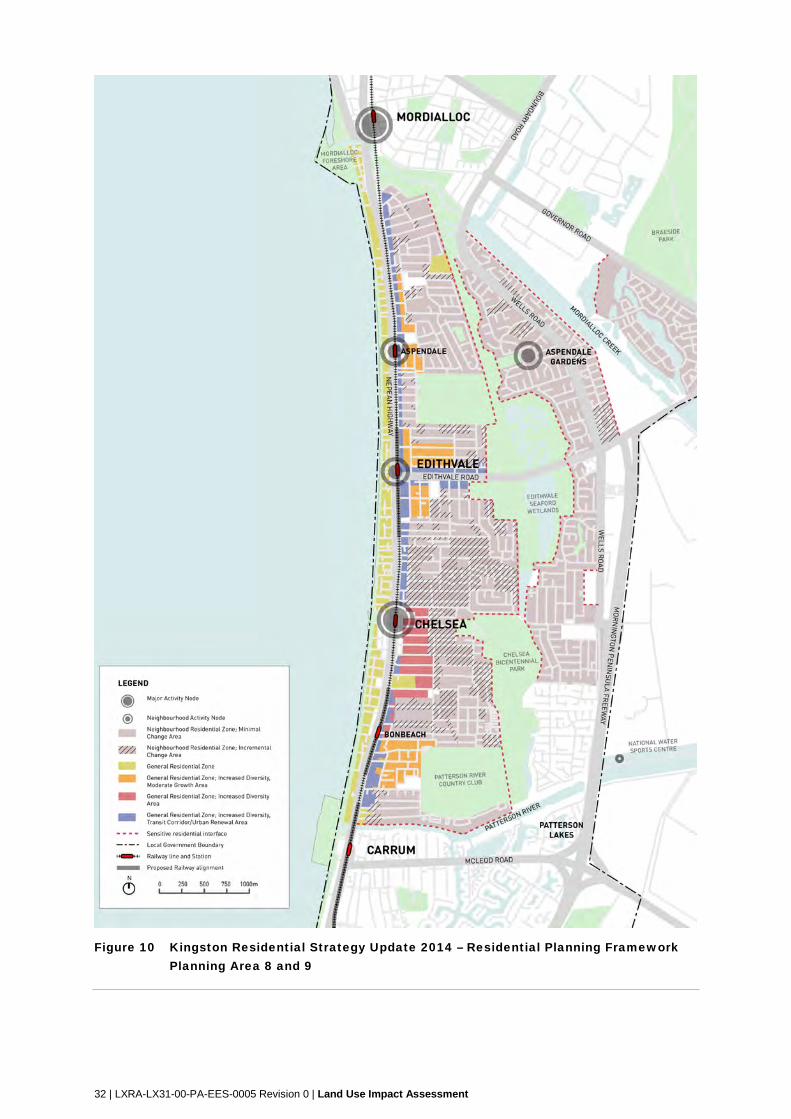
The Kingston Residential Strategy Update 2014 policy is an update to the Kingston Residential
Strategy 2000 which was prepared to address residential development within Kingston. The
Strategy update was prepared to assist in managing the planning and regulatory aspects of
residential development in the municipality and aims ‘to promote and facilitate increased local
housing diversity to meet the changing housing needs of the community and increased
liveability within an integrated planning framework’.
The strategy proposes that ‘in areas serviced by rail, opportunities exist to increase population
density to maximise patronage levels and reduce potential environmental impacts’.
The strategy proposes that there will be residential consolidation and increased densities within
the Edithvale Neighbourhood Activity Centre, along major arterial roads such as Nepean
Highway and close to public transportation (close to Edithvale and Bonbeach Train Stations).
Planning Area Residential Frameworks within the strategy address residential land use issues
at localised sites.
The following ‘Planning Areas’ are relevant for the purpose of this report:
Planning Area 8 (Aspendale, Aspendale Gardens and Edithvale).
Planning Area 9 (Chelsea, Chelsea Heights and Bonbeach).
Planning Areas 8 and 9 are shown on Figure 10 below.
The strategy has informed Clause 21.05 (Residential Land Use) of the Scheme which is
discussed in Section 5.3.1.
32 | LXRA-LX31-00-PA-EES-0005 Revision 0 | Land Use Impact Assessment
Figure 10 Kingston Residential Strategy Update 2014 – Residential Planning Framework Planning Area 8 and 9
LXRA-LX31-00-PA-EES-0005 Revision 0 | Land Use Impact Assessment | 33
5.1.3.4 Kingston Open Space Strategy (2012)
The Kingston Open Space Strategy (2012) provides an analysis of open space within the
municipality of Kingston and provides recommendations in relation to the management and
maintenance of the Kingston open space resource and the vision for the future of these areas.
This strategy is relevant to recreation and open space land use.
5.2 Edithvale project
5.2.1 Land Use
Existing land use within the Edithvale study area is described below and shown in the Edithvale
study area and land use map at Figure 3.
5.2.1.1 Railway
The Frankston rail line runs the full length of the Edithvale study area and is located between
Nepean Highway (a major state arterial road) and Station Street. It has two tracks which run the
full length and sits roughly at grade with the adjacent roads.
Edithvale Station is located to the north of Edithvale Road, it has side platforms which are
accessed from Nepean Highway and Station Street and access between the platforms is by the
pedestrian level crossing at Edithvale Road. The station contains 34 car parking spaces to the
south of Edithvale Road and five bike racks.
There are eight pedestrian level crossings within the study area located at:
Birdwood Street, Second Avenue, Lochiel Avenue, Aspendale
Edithvale shops (Between Denman and Sinclair Avenue)
Edithvale Station (Edithvale Road)
Fraser and Berry Avenue, Edithvale
Swanpool Avenue, Chelsea.
There are three level crossings within the study area are located at:
Lochiel Avenue, Aspendale
Edithvale Road, Edithvale
Swanpool Avenue, Chelsea.
Land within the rail corridor is zoned PUZ4, except for where it crosses Edithvale Road, where it
is zoned RDZ1.
5.2.1.2 Major roads
Major Roads within the study area include Nepean Highway and Edithvale Road, which are
both arterial roads and zoned RDZ1.
More than 12,000 vehicles per day use the level crossing between Edithvale Road and Nepean
Highway.
The Nepean Highway at Edithvale is an important arterial road forming part of the Nepean
Corridor which runs from Frankston to St Kilda.
Edithvale Road runs from the Nepean Highway to Wells Road, where it becomes Springvale
Road. It is a major east-west connector to employment and services for Edithvale and
surrounding local areas.
34 | LXRA-LX31-00-PA-EES-0005 Revision 0 | Land Use Impact Assessment
5.2.1.3 Commercial
The Edithvale Neighbourhood Centre is located in the Edithvale study area and is anchored by
the Edithvale Station. The Centre is located between larger activity centres including Chelsea to
the south and Mordialloc to the north.
The west side of Nepean Highway forms a continuous, albeit one sided ‘high street’
environment for the Neighbourhood Centre, with active street frontages of retail shops and
providing some overhead canopies and weather protection.
The Centre provides a local supermarket and smaller tenancies comprising cafés, small shops,
and personal and professional services.
Commercial land use is generally contained within the Commercial 1 Zone (C1Z) and centred
around but opposite Edithvale Station. Out of centre commercial development within the study
area includes a small strip of shops on Nepean Highway within the C1Z, north of Kelvin Grove
and a service station within the General Residential Zone 2 (GRZ2), on the corner of Station
Street and Lochiel Avenue.
5.2.1.4 Residential
Residential lands uses are located east of the railway line, west of the railway line between the
commercial strip and the beach and further north and south along the western side of the
Nepean Highway.
Lots are generally between 500-700 square metres in size, developed in the post war era
(1950’s to 1960’s). There has been some recent subdivision and redevelopment of up to four
storey, especially along Station Street and Nepean Highway, increasing the amount of medium
density housing in the area. Beyond this, the study area retains a predominantly low rise and
low density residential character.
Residential land use within the study area is largely found within the GRZ2, however some
mixed use developments and residential exist within the C1Z.
5.2.1.5 Education
Edithvale Primary School sits approximately 500 metres east of Edithvale Station and services
a local catchment. The school is zoned Public Use Zone 2 – Education (PUZ2).
A local preschool is located within the GRZ2 on Fraser Avenue.
5.2.1.6 Open space
The study area includes a number open space and recreational amenities, including Edithvale
Beach and the Port Phillip foreshore. Approximately 600metres north-east of the station,
Regents Park provides passive and recreational facilities for the local area. Abutting Regents
Park, the Rossdale Golf Club provides additional recreational facilities in the area. Beeson
Reserve is located adjacent to Edithvale Station and forms an important open space link
between the station and the foreshore and lifesaving club.
Parks and the Port Phillip foreshore within the study area are generally zoned PPRZ with the
exception of Beeson Reserve which is zoned GRZ2. The Rossdale Golf Club is zoned Special
Use Zone 1 - Golf Courses (SUZ1).
LXRA-LX31-00-PA-EES-0005 Revision 0 | Land Use Impact Assessment | 35
5.2.1.7 Community
The following community facilities are located with the study area:
two aged care facilities (256-260 Station Street and 10-12 Northcliffe Road, Edithvale)
facilities at Regents Park (600 metres north-east of Edithvale Station):
o Aspendale Tennis club
o sports pavilion
o Edithvale Scout Group
Edithvale preschool (29 Fraser Avenue, Edithvale)
Chelsea Childcare Centre (10 Swanpool Avenue, Chelsea)
Edithvale Life Saving Club – Including a community room and café (approximately 170 metres west of Edithvale Station)
Uniting Church in Australia Chelsea (approximately 100 metres east of Edithvale Station).
Community facilities are generally zoned GRZ2 within the study area, with the exception of the Life Saving Club and the facilities located Regents Park which are located within the PPRZ.
5.2.2 Likely future development patterns
Consultation with the City of Kingston planning department has indicated that the current development trends within the Edithvale study area are likely to continue in to the future, that is, moderate increased density, particularly along arterial roads and close to public transport. Within the study area, updates to local planning strategies and the Kingston Planning Scheme are likely to be generally policy neutral.
5.3 Bonbeach project
5.3.1 Land Use
Existing land use within the Bonbeach study area is described below and shown in the Edithvale study area and land use map at Figure 4.
5.3.1.1 Railway
The Frankston rail line runs the full length of the Bonbeach study area and sits between Nepean Highway and Station Street It has two tracks which run the full length and sits roughly at grade with the adjacent roads.
Bonbeach Station is located to the north of Bondi Road, Bonbeach, it has side platforms which are accessed from Nepean Highway and Station Street and access between the platforms is by the pedestrian level crossing at Bondi Road. The station contains 35 car parking spaces to the south of Bondi Road along Station Street and 11 bicycle racks.
There are six pedestrian level crossings within the study area located at:
Argyle Avenue, Chelsea
Golden Avenue, Wellwood Road, Bondi Road, The Glade, Mascot Avenue, Bonbeach.
There are three level crossings within the study area located at:
Argyle Avenue, Chelsea
Station Street, Bonbeach
Mascot Avenue, Bonbeach.
Land within the rail corridor is zoned PUZ4.
36 | LXRA-LX31-00-PA-EES-0005 Revision 0 | Land Use Impact Assessment
5.3.1.2 Major Roads
Nepean Highway is the only road within the study area which is VicRoads controlled and zoned RDZ1.
The Nepean Highway at Edithvale is an important arterial road forming part of the Nepean Corridor which runs from Frankston to St Kilda and carries over 135,000 people per day.
5.3.1.3 Commercial
A limited number of commercial uses sit opposite the Station on the western side of the Nepean Highway. Local services and uses include cafés, small shops, and personal and professional services. There are a number of vacant tenancies or commercial premises no longer being used for retail or services.
A small amount of retail activity exists within residential areas on the corner of Breese Street and Patterson Street, Bonbeach, however this is limited to corner store type shops.
Commercial land use within the study area is confined to the C1Z.
5.3.1.4 Residential
Other than the limited commercial land uses opposite the Station on the western side of the Nepean Highway, the land use within the study area is predominately residential.
Lots are a variety of sizes, and generally have been developed in the post war era (1950’s to 1960’s). There is a mix of low rise and low density housing and townhouse developments. There has been some recent subdivision and redevelopment and intensification of housing in the area, especially along Station Street and Nepean Highway, but a low lying coastal residential character is largely retained.
Residential land use within the study area is largely found within the GRZ2, however some mixed use developments exist within the C1Z.
5.3.1.1 Education
Three schools fall within the study area:
Bonbeach Primary School (29-63 Breeze Street, Bonbeach)
Chelsea Primary School (34-44 Argyle Street, Chelsea)
St Joseph’s School Chelsea (362 Station Street, Chelsea).
Bonbeach Primary and Chelsea Primary are located within the PUZ2 – Education whilst St Joseph’s School is located within the GRZ2.
5.3.1.5 Open space
The study area includes the Port Phillip foreshore with a number of beaches within immediate walking distance of the Station. Additionally, the area has few smaller, local level open spaces.
Open space within the study area is generally zoned PPRZ.
There are a number of large open space areas close to Bonbeach, however they fall outside the study area to the east.
5.3.1.6 Community
There are a number of community facilities located in the local area. South of the station, along Station Street, is Bonbeach Residential Care and Nursing Home, located in the GRZ2.
Bonbeach Preschool is adjacent to the Bonbeach Primary School at 29-63 Breeze Street, Bonbeach and zoned PUZ 2 – Education.
Bonbeach Life Saving Club, south-west of the Station, is a key community focal point and includes a community room and café. The Club is located within the PPRZ.
LXRA-LX31-00-PA-EES-0005 Revision 0 | Land Use Impact Assessment | 37
5.3.2 Likely future development patterns
Consultation with the City of Kingston planning department has indicated that the current
development trends within the Edithvale study area are likely to continue in to the future, that is,
moderate increased density, particularly along arterial roads and close to public transport.
Within the study area, updates to local planning strategies and the Kingston Planning Scheme
are likely to be generally policy neutral.
5.4 Temporary construction and laydown areas
The construction of the projects would require the use of temporary construction and laydown
areas. No sites have yet been identified and accordingly an assessment of relevant local
existing conditions is not possible at this time.
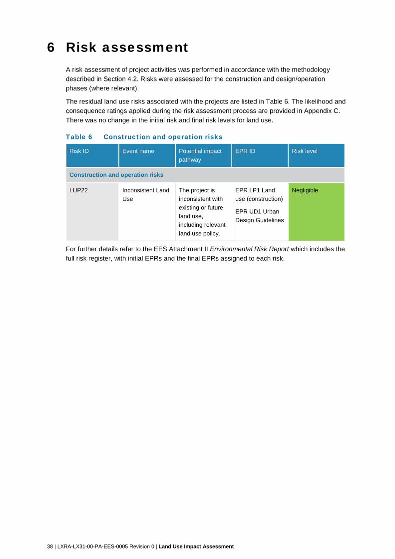
38 | LXRA-LX31-00-PA-EES-0005 Revision 0 | Land Use Impact Assessment
6 Risk assessment A risk assessment of project activities was performed in accordance with the methodology
described in Section 4.2. Risks were assessed for the construction and design/operation
phases (where relevant).
The residual land use risks associated with the projects are listed in Table 6. The likelihood and
consequence ratings applied during the risk assessment process are provided in Appendix C.
There was no change in the initial risk and final risk levels for land use.
Table 6 Construction and operation risks
Risk ID Event name Potential impact
pathway
EPR ID Risk level
Construction and operation risks
LUP22 Inconsistent Land
Use
The project is
inconsistent with
existing or future
land use,
including relevant
land use policy.
EPR LP1 Land
use (construction)
EPR UD1 Urban
Design Guidelines
Negligible
For further details refer to the EES Attachment II Environmental Risk Report which includes the
full risk register, with initial EPRs and the final EPRs assigned to each risk.
LXRA-LX31-00-PA-EES-0005 Revision 0 | Land Use Impact Assessment | 39
7 Impact assessment 7.1 Edithvale project impact assessment
Land use impacts during construction are generally temporary in duration and limited in nature,
and are associated with activities that can be inconsistent with established land use. Uses can
relate to the temporary occupation of roads or land for the purpose of and during construction.
Potential land use impacts during construction are identified in Section 7.1.1 below.
Land use impacts during the operation of the Edithvale project are considered to be negligible.
The use and development of rail infrastructure within an established rail corridor, zoned for the
purposes of transport infrastructure is consistent with the established land use and identified
land use policies. Potential land use impacts during operation are discussed in Section 7.1.2
below.
Land use impacts for temporary construction and laydown sites have not been assessed as
these sites are yet to be identified.
7.1.1 Construction impacts
7.1.1.1 Land Use
During construction, the Edithvale project is anticipated to result in a number of temporary
changes to existing land uses, including:
temporary occupation of road reserves for non-traffic purposes (construction)
relocation and construction of minor utility installations
temporary construction and laydown areas.
The construction of the Edithvale project would result in changes to existing land uses, which is
temporarily inconsistent with the existing land use (risk LUP22). This impact is considered
negligible and is discussed below.
Use of rail
During construction, rail services will be disrupted from time to time. This is not inconsistent with
the land use of the rail corridor. Impacts of service disruption to the users of the passenger rail
system has been considered in EES Technical Report L Social.
Use of roads
The primary purpose of a road is to provide for access for vehicles, pedestrians and cyclists.
The construction methodology proposed for the project will require the temporary use of some
road reserves. During periods of construction, the road will be used in manner inconsistent with
the established land use and is a land use impact. As this occupancy is also temporary, and as
alternate access will be made available, this impact is considered to be negligible.
The Edithvale project would also be constructed to:
avoid or minimise impacts to existing land uses on private and public land (including
public open space) from temporary works and permanent structures as far as practicable
reduce the disruption to the extent practicable to current users of public land resulting
from temporary occupation
include opportunities to implement landscaping enhancement
40 | LXRA-LX31-00-PA-EES-0005 Revision 0 | Land Use Impact Assessment
ensure the projects and any associated development make a positive contribution to the
structure and function of the adjoining land and local area and meet the requirements of LXRA's Urban Design Framework and Guidelines for the projects (EPR_LP1 and
EPR_UD1).
These mitigations will maintain a negligible impact.
No further land use mitigation measures are considered required or recommended.
Utilities
The construction of the Edithvale project will require the relocation of existing utility services
such as water, gas, sewerage and telecommunications. The relocation of utilities is required to
allow the project to be constructed in a safe and efficient manner. The relocation of existing
utility services is not generally inconsistent with existing land uses (either within or adjacent to
the rail corridor). Utility services are commonly located underground within road reserves, the
rail corridor and on occasion, private land. Carefully considered, the construction of the project
need not result in a change to or an impact on a land use, and consequently its impact is
considered to be negligible.
The Edithvale project would also be constructed to:
avoid or minimise impacts to existing land uses on private and public land (including
public open space) from temporary works and permanent structures as far as practicable
reduce the disruption to the extent practicable to current users of public land resulting
from temporary occupation
include opportunities to implement landscaping enhancement
ensure the projects and any associated development make a positive contribution to the
structure and function of the adjoining land and local area and meet the requirements of
LXRA's Urban Design Framework and Guidelines for the projects (EPR_LP1 and
EPR_UD1).
These mitigations will maintain a negligible impact.
No other land use mitigation measures are considered required or recommended.
Temporary construction and laydown areas
Refer Section 7.3 of this Report.
Amenity Impacts
During the construction period there may be amenity impacts that include accessibility, air
quality, noise and vibration and an increase in construction traffic. The detail of these potential
amenity impacts together with any relevant mitigation measures have been assessed more
specifically within the EES technical reports listed in Section 4.5.
The potential amenity impacts are not expected to impact on land uses and as such can be
considered to be negligible.
No land use mitigation measures are considered required or recommended.
LXRA-LX31-00-PA-EES-0005 Revision 0 | Land Use Impact Assessment | 41
7.1.2 Operational impacts
7.1.2.1 Strategic planning policy
The land use of the Edithvale project is consistent with, and supported by, the SPPF and LPPF
in the Scheme (risk LUP22), and particularly:
Plan Melbourne - Policy 3.1.1 - The improved rail frequency and reliability resulting from
the project is consistent with the policy of creating a metro-style rail system. The project is
consistent with and supported by Policy 3.1.2 by enhancing access to activity centres
along the Frankston rail corridor and Policy 3.1.3 by improving the efficiency and safety of
the arterial road network.
LPPF - Clause 21.05 Residential land use – The Scheme identifies Edithvale as a
Neighbourhood Activity Centre and an area for promotion of increased housing diversity
proximate to transport infrastructure. The improved rail, road, bicycle and pedestrian
access resulting from the project would support increasing residential densities in this
area and is consistent with the policy.
LPPF - Clause 21.12 Transport, movement and access – The Scheme seeks to protect
and enhance the amenity of Kingston’s residential areas and other sensitive land uses
though appropriate management of transport networks. The project supports this
objective by the improving the efficiency of existing rail and road infrastructure on land
that is dedicated for transport purposes.
The project is considered to be consistent with the intended and strategic directions considered
for the land use in the Edithvale study area and implements the identified policies as above.
No mitigation measures are considered required or recommended.
7.1.2.2 Land Use
Rail corridor and infrastructure
The Edithvale project is consistent with, and supported by, existing and future land use (risk
LUP22).
The Edithvale project will operate within the Frankston rail corridor, which is consistent with the
existing land use. The Edithvale project will operate within land zoned PUZ4 or RDZ1 and is
wholly consistent with the purpose of the zones. The impact to existing land use is therefore
considered negligible.
The Edithvale project would be designed and constructed to:
avoid or minimise impacts to existing land uses on private and public land (including
public open space) from temporary works and permanent structures as far as practicable
reduce the disruption to the extent practicable to current users of public resulting from
temporary occupation
include opportunities to implement landscaping enhancement
ensure the projects and any associated development make a positive contribution to the
structure and function of the adjoining land and local area and meet the requirements of
LXRA's Urban Design Framework and Guidelines for the projects (EPR_LP1 and
EPR_UD1).
These mitigations will maintain a negligible impact.
No other mitigation measures are considered required or recommended.
42 | LXRA-LX31-00-PA-EES-0005 Revision 0 | Land Use Impact Assessment
Substation
The construction of the Edithvale project also requires the construction of a substation to
support the safe and efficient operation of the rail service. The location of minor rail
infrastructure utilities within the rail corridor is consistent with the existing and future land use of
the rail corridor and its impact from a land use perspective is considered to be negligible.
The Edithvale project would also be constructed to:
avoid or minimise impacts to existing land uses on private and public land (including
public open space) from temporary works and permanent structures as far as practicable
reduce the disruption to the extent practicable to current users of public land resulting
from temporary occupation
include opportunities to implement landscaping enhancement
ensure the projects and any associated development make a positive contribution to the
structure and function of the adjoining land and local area and meet the requirements of
LXRA's Urban Design Framework and Guidelines for the projects (EPR_LP1 and
EPR_UD1).
These mitigations will maintain a negligible impact.
No other land use mitigation measures are considered required or recommended.
Amenity Impacts
During the operation of the Edithvale project there may be amenity impacts that include air
quality, noise and vibration. The detail of these potential amenity impacts together with any
relevant mitigation measures have been assessed more specifically within the EES technical
reports listed in Section 4.5.
Within this context, the potential amenity impacts are not expected to impact on land uses and
as such can be considered to be negligible.
No land use mitigation measures are considered required or recommended.
7.2 Bonbeach project impact assessment
Land use impacts during construction are generally temporary in duration and limited in nature,
and are associated with activities that can be inconsistent with established land use. Uses can
relate to the temporary occupation of roads or land for the purpose of and during construction.
Potential land use impacts during construction are identified in Section 7.2.1 below.
Land use impacts during the operation of the Bonbeach project are considered to be negligible.
The use and development of rail infrastructure within an established rail corridor, zoned for the
purposes of transport infrastructure is consistent with the established land use and identified
land use policies. Potential land use impacts during operation are discussed in Section 7.2.2
below.
Land use impacts for temporary construction and laydown sites have not been assessed as
these sites are yet to be identified.
LXRA-LX31-00-PA-EES-0005 Revision 0 | Land Use Impact Assessment | 43
7.2.1 Construction impacts
7.2.1.1 Land Use
During construction, the Bonbeach project is anticipated to result in a number of temporary
changes to existing land uses, including:
temporary occupation of road reserves for non-traffic purposes (construction)
relocation and construction of minor utility installation
temporary construction and laydown areas.
The construction of the Bonbeach project would result in changes to existing land uses, which is
temporarily inconsistent with the existing land use (risk LUP22). This impact is considered
negligible and is discussed below.
Use of rail
During construction, rail services will be disrupted from time to time. This is not inconsistent with
the land use of the rail corridor.
Use of roads
The primary purpose of a road is to provide for access for vehicles, pedestrians and cyclists.
The construction methodology proposed for the project will require the temporary use of some
road reserves. During periods of construction, the road will be used in manner inconsistent with
the established land use and is a land use impact. As this occupancy is also temporary, and as
alternate access will be made available, this impact is considered to be negligible.
The Bonbeach project would also be constructed to:
avoid or minimise impacts to existing land uses on private and public land (including
public open space) from temporary works and permanent structures as far as practicable
reduce the disruption to the extent practicable to current users of public land resulting
from temporary occupation
include opportunities to implement landscaping enhancement
ensure the projects and any associated development make a positive contribution to the
structure and function of the adjoining land and local area and meet the requirements of
LXRA's Urban Design Framework and Guidelines for the projects (EPR_LP1 and
EPR_UD1).
These mitigations will maintain a negligible impact.
No further land use mitigation measures are considered required or recommended.
Utilities
The construction of the Bonbeach project will require the relocation of existing utility services
such as water, gas, sewerage and telecommunications. The relocation of utilities is required to
allow the project to be constructed in a safe and efficient manner. The relocation of existing
utility services is not generally inconsistent with existing land uses (either within or adjacent to
the rail corridor). Utility services are commonly located underground within road reserves, the
rail corridor and on occasion, private land. Carefully considered, the construction of the project
need not result in a change to or an impact on a land use, and consequently its impact is
considered to be negligible.
44 | LXRA-LX31-00-PA-EES-0005 Revision 0 | Land Use Impact Assessment
The Bonbeach project would also be constructed to:
avoid or minimise impacts to existing land uses on private and public land (including public open space) from temporary works and permanent structures as far as practicable
reduce the disruption to the extent practicable to current users of public land resulting from temporary occupation
include opportunities to implement landscaping enhancement
ensure the projects and any associated development make a positive contribution to the structure and function of the adjoining land and local area and meet the requirements of LXRA's Urban Design Framework and Guidelines for the projects (EPR_LP1 and EPR_UD1).
These mitigations will maintain a negligible impact.
No other land use mitigation measures are considered required or recommended.
Amenity Impacts
During the construction period there may be amenity impacts that include accessibility, air quality, noise and vibration and an increase in construction traffic. The detail of these potential amenity impacts together with any relevant mitigation measures have been assessed more specifically within the EES technical reports listed in Section 4.5.
The potential amenity impacts are not expected to impact on land uses and as such can be considered to be negligible.
No land use mitigation measures are considered required or recommended.
Temporary construction and laydown areas
Refer Section 7.3 of this Report.
7.2.2 Operational impacts
7.2.2.1 Strategic Planning Policy Support
The land use of the Bonbeach project is consistent with, and supported by, the SPPF and LPPF in the Scheme (risk LUP22), and particularly:
Plan Melbourne (Policy 3.1.1) – The improved rail frequency and reliability resulting from the project is consistent with the policy of creating a metro-style rail system. The Bonbeach project is consistent with and supported by Policy 3.1.2 by enhancing access to activity centres along the Frankston rail corridor and Policy 3.1.3 by improving the efficiency and safety of the arterial road network.
LPPF (Clause 21.05 Residential land use) – The Scheme identifies Bonbeach as an area for promotion of increased housing diversity proximate to transport infrastructure. The improved rail, road, bicycle and pedestrian access resulting from the project would support increasing residential densities in this area and is consistent with the policy.
LPPF (Clause 21.12 Transport, movement and access) – The Scheme seeks to protect and enhance the amenity of Kingston’s residential areas and other sensitive land uses though appropriate management of transport networks. The project supports this objective by the improving the efficiency of existing rail and road infrastructure on land that is dedicated for transport purposes.
The project is considered to be consistent with the intended and strategic directions considered for the land use in the Bonbeach study area.
No mitigation measures are considered required or recommended.
LXRA-LX31-00-PA-EES-0005 Revision 0 | Land Use Impact Assessment | 45
7.2.2.2 Land Use
The Bonbeach project is consistent with, and supported by, existing and future land use in the
Scheme (risk LUP22).
The Bonbeach project will operate within the Frankston rail corridor, which is consistent with the
existing land use. The project will operate within land zoned PUZ 4 – Transport (the rail corridor)
and is wholly consistent with the purpose of the zones. The impact to existing land use is
therefore considered negligible as the project would be entirely consistent with existing land
use.
Impacts resulting from the operation of the Bonbeach project unrelated to land use have been
considered in the EES technical reports listed in Section 4.5.
The Bonbeach project would be designed and constructed to:
avoid or minimise impacts to existing land uses on private and public land (including
public open space) from temporary works and permanent structures as far as practicable
reduce the disruption to the extent practicable to current users of public land resulting
from temporary occupation
include opportunities to implement landscaping enhancement
ensure the projects and any associated development make a positive contribution to the
structure and function of the adjoining land and local area and meet the requirements of LXRA's Urban Design Framework and Guidelines for the projects (EPR_LP1 and
EPR_UD1).
These mitigations will maintain a negligible impact.
No other mitigation measures are considered required or recommended.
Amenity Impacts
During the operation of the Bonbeach project there may be amenity impacts that include air
quality, noise and vibration. The detail of these potential amenity impacts together with any
relevant mitigation measures have been assessed more specifically within the EES technical
reports listed in Section 4.5.
Within this context, the potential amenity impacts are not expected to impact on land uses and
as such can be considered to be negligible.
No land use mitigation measures are considered required or recommended.
7.3 Temporary construction and laydown areas impact assessment
The construction phase of the projects would require the temporary use of land for site offices
and construction laydown areas. To date, no site offices and construction laydown areas have
been identified.
Suitable sites are still being explored with relevant parties and accordingly site specific
assessment of impacts is not possible at this time.
However, the following paragraphs discuss potential settings for these areas and matters likely
to require consideration and management to minimise and manage impacts.
46 | LXRA-LX31-00-PA-EES-0005 Revision 0 | Land Use Impact Assessment
The following options are likely to exist for temporary site offices and construction laydown:
existing industrial land in the area that would be leased for the duration of the
construction of the projects
rural land
land used for existing passive or active recreational purposes.
If sites on land zoned for industrial purposes are identified, it is unlikely that the projects will
result in an inconsistent land use, however LXRA may still need to seek planning approval to
use the land.
The use of rural land, or land currently used as public open space for passive or active
recreation could result in temporary land uses that are inconsistent with the land use policies
and controls affecting the land. LXRA would seek planning approval for the temporary use of
the land.
The sites considered for this purpose should be selected and managed to minimise land use
conflict, site area, impact to existing land uses within and adjacent to the identified areas and be
reinstated to enable previous land uses to recommence.
Planning approval under any scenario would require an assessment of the potential effects
appropriate to the identified site, consultation with potentially affected parties including key
stakeholders, landowners, land users and neighbouring/nearby residents, and include specific
conditions that the project would need to meet to manage any potential impacts and with regard
to reinstatement of the previous land use.
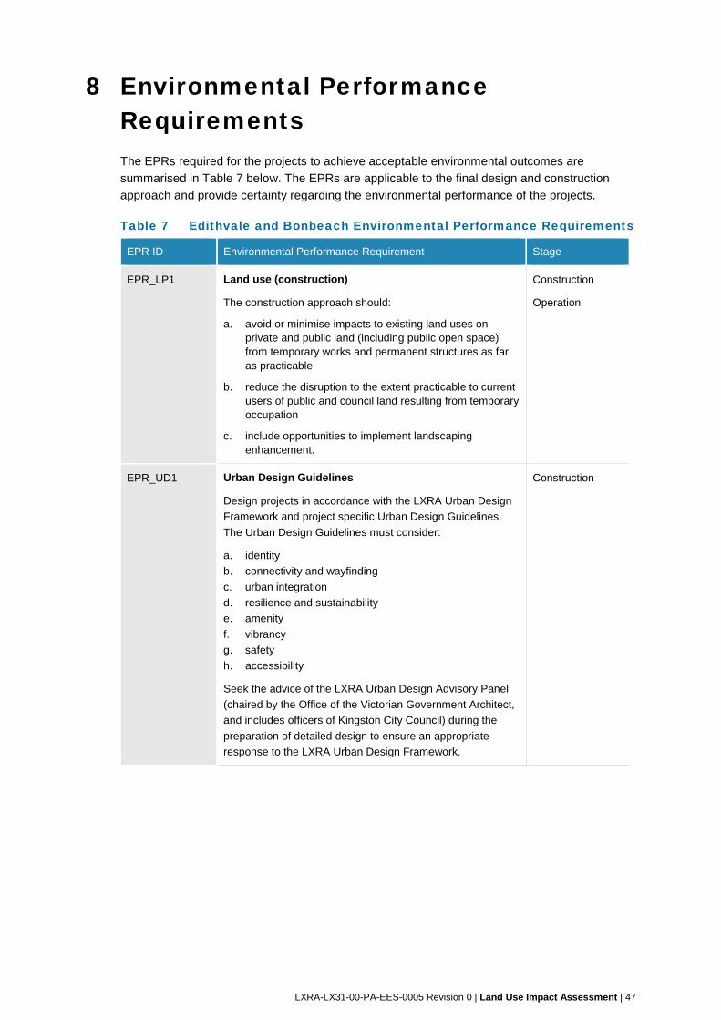
LXRA-LX31-00-PA-EES-0005 Revision 0 | Land Use Impact Assessment | 47
8 Environmental Performance Requirements The EPRs required for the projects to achieve acceptable environmental outcomes are
summarised in Table 7 below. The EPRs are applicable to the final design and construction
approach and provide certainty regarding the environmental performance of the projects.
Table 7 Edithvale and Bonbeach Environmental Performance Requirements
EPR ID Environmental Performance Requirement Stage
EPR_LP1 Land use (construction)
The construction approach should:
a. avoid or minimise impacts to existing land uses on private and public land (including public open space) from temporary works and permanent structures as far as practicable
b. reduce the disruption to the extent practicable to current users of public and council land resulting from temporary occupation
c. include opportunities to implement landscaping enhancement.
Construction
Operation
EPR_UD1 Urban Design Guidelines
Design projects in accordance with the LXRA Urban Design
Framework and project specific Urban Design Guidelines.
The Urban Design Guidelines must consider:
a. identity
b. connectivity and wayfinding
c. urban integration
d. resilience and sustainability
e. amenity
f. vibrancy
g. safety
h. accessibility
Seek the advice of the LXRA Urban Design Advisory Panel
(chaired by the Office of the Victorian Government Architect,
and includes officers of Kingston City Council) during the
preparation of detailed design to ensure an appropriate
response to the LXRA Urban Design Framework.
Construction
48 | LXRA-LX31-00-PA-EES-0005 Revision 0 | Land Use Impact Assessment
9 Conclusion A land use impact assessment has been undertaken for the project to determine the impacts of
the project on land use, and to identify management and mitigation options where appropriate in
order to reduce potential risks of the project.
Existing conditions
The project is proposed to be constructed within the Frankston rail corridor, in established areas
within Edithvale, Chelsea and Bonbeach. These areas contain well-established residential
areas, shopping and commercial centres, parks and reserves, and community and recreational
facilities.
Impact assessment
Land use impact has been assessed during both the construction and operation of the project.
Land use impacts are primarily associated with the construction period and are temporary in
duration, contained in effect and are considered negligible.
Land use impacts during construction would also be addressed through the identified EPRs,
standard construction management practices, and compliance with statutory regulations and
standards.
Land use impacts for temporary construction and laydown areas have not been assessed as
these sites have yet to be identified. Land use impacts associated with the temporary
construction and laydown areas would be addressed through the relevant EPR.
The project is consistent with the existing land use of the rail corridor, and is both consistent
with, supported by and implements the identified State and local government land use policies.
These policies support the current and future land use of the project area as a transport
corridor. Land use impacts during operation of the project are considered negligible.
The impact assessment identified the following benefits for land use that may be associated
with the chosen design solutions for the projects:
no property acquisition is required to facilitate the design
consistent with State and local planning policy
complimentary to existing and potential future surrounding land uses.
Residual risk
This assessment has considered impacts of the project to land use within the study areas
during construction and operation. Identified risks during construction are considered to be
negligible and identified risks during operation are also considered to be negligible. The relevant
EPRs set out parameters for construction methodology to reduce the identified impacts on land
use. The residual risk is therefore considered to be negligible.
As noted above, land use impacts for temporary site office and construction laydown areas
have not been assessed at this time, however an EPR has been developed to guide the
selection and operation of temporary site and laydown areas.
LXRA-LX31-00-PA-EES-0005 Revision 0 | Land Use Impact Assessment | 49
10 References Charter Keck Cramer, City of Kingston, Hansen Partnership (2006). Retail/Commercial
Development Strategy
City of Kingston (2007). Kingston Neighbourhood Character Guidelines
City of Kingston (2012a). Kingston Planning Scheme Review 2010 - 2012
City of Kingston (2012b) Open Space Strategy
City of Kingston (2014). Draft Kingston Residential Strategy Update
City of Kingston (2016). Prosperous Kingston – A Framework for Economic Sustainability
DELWP Planning Maps online. Administered by the Department of Environment, Land, Water
and Planning. Available at http://services.land.vic.gov.au/maps/pmo.jsp
DELWP Planning Schemes online. Administered by the Department of Environment, Land,
Water and Planning. Available at http://planning-schemes.delwp.vic.gov.au/
Public Transport Victoria (2012), Network Development Plan – Metropolitan Rail
The State of Victoria, Department of Environment, Land, Water and Planning (2017) Plan
Melbourne 2017 – 2050: Metropolitan Planning
LXRA-LX31-00-PA-EES-0005 Revision 0 | Land Use Impact Assessment
Appendix A – Planning Zones
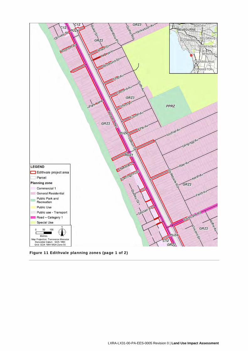
LXRA-LX31-00-PA-EES-0005 Revision 0 | Land Use Impact Assessment
Figure 11 Edithvale planning zones (page 1 of 2)
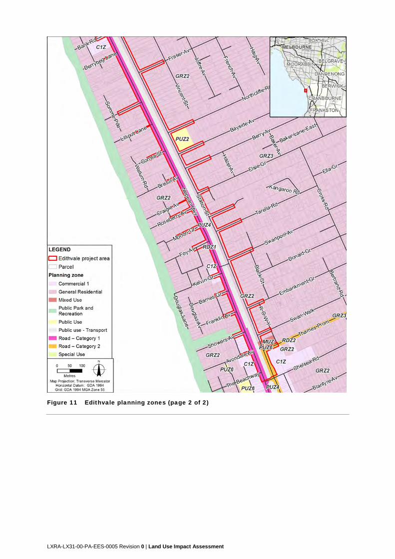
LXRA-LX31-00-PA-EES-0005 Revision 0 | Land Use Impact Assessment
Figure 11 Edithvale planning zones (page 2 of 2)
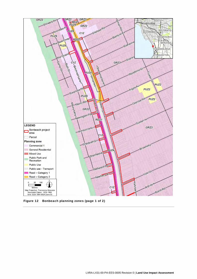
LXRA-LX31-00-PA-EES-0005 Revision 0 | Land Use Impact Assessment
Figure 12 Bonbeach planning zones (page 1 of 2)
LXRA-LX31-00-PA-EES-0005 Revision 0 | Land Use Impact Assessment
Figure 12 Bonbeach planning zones (page 2 of 2)

LXRA-LX31-00-PA-EES-0005 Revision 0 | Land Use Impact Assessment
Appendix B – Planning Overlays
LXRA-LX31-00-PA-EES-0005 Revision 0 | Land Use Impact Assessment
Figure 13 Edithvale planning overlays (page 1 of 2)
LXRA-LX31-00-PA-EES-0005 Revision 0 | Land Use Impact Assessment
Figure 13 Edithvale planning overlays (page 2 of 2)
LXRA-LX31-00-PA-EES-0005 Revision 0 | Land Use Impact Assessment
Figure 14 Bonbeach planning overlays (page 1 of 2)
LXRA-LX31-00-PA-EES-0005 Revision 0 | Land Use Impact Assessment
Figure 14 Bonbeach planning overlays (page 2 of 2)

LXRA-LX31-00-PA-EES-0005 Revision 0 | Land Use Impact Assessment
Appendix C – Risk assessment
LXRA-LX31-00-PA-EES-0005 Revision 0 | Land Use Impact Assessment
Table C1 Guide to quantification of likelihood
Qualitative descriptions Probability over a given time
period
Basis
A. Certain 1 (or 0.999, 99.9%) Certain, or as near to as makes no
difference
B. Almost certain 0.2 – 0.9 One or more incidents of a similar
nature has occurred here
C. Highly probable 0.1 A previous incident of a similar
nature has occurred here
D. Possible 0.01 Could have occurred already
without intervention
E. Unlikely 0.001 Recorded recently elsewhere
F. Very unlikely 1 x 10⁻⁴ It has happened elsewhere
G. Highly improbable 1 x 10⁻⁵ Published information exists, but in
a slightly different context
H. Almost impossible 1 X 10⁻⁶ No published information on a
similar case
Source: Bowden, A.R., Lane, M.R. and Martin, J.H., 2001, Triple Bottom Line Risk Management – Enhancing Profit,
Environmental Performance and Community Benefit, Wiley and Sons, New York, 314 pp.
Tab
le C
2 C
onse
quen
ce t
able
use
d fo
r la
nd u
se r
isk
asse
ssm
ent
Qu
alit
ativ
e d
escr
ipto
r N
eg
ligib
le
Min
or
Mo
de
rate
M
ajo
r E
xtre
me
Co
ns
eq
uen
ce
d
es
cri
pti
on
M
inim
al,
if
an
y im
pa
ct
for
so
me
co
mm
un
itie
s.
Po
ten
tia
lly
so
me
im
pa
ct
for
a s
ma
ll n
um
be
r (<
10
) o
f in
div
idu
als
Lo
w le
vel
imp
act
for
so
me
co
mm
un
itie
s,
or
hig
h i
mp
ac
t fo
r a
sm
all
n
um
ber
(<
10)
of
ind
ivid
ua
ls
Hig
h l
eve
l o
f im
pac
t fo
r s
om
e c
om
mu
nit
ies
, o
r m
od
erat
e im
pac
t fo
r c
om
mu
nit
ies
are
a-w
ide
Hig
h l
eve
l o
f im
pac
t fo
r c
om
mu
nit
ies
are
a-w
ide
Hig
h l
eve
l o
f im
pa
ct
Sta
te-w
ide
0.1
0.3
13
10
30
10
03
00
10
00
SO
CIA
L
La
nd
Us
e P
lan
nin
g
Ne
glig
ible
imp
act
on
exi
stin
g a
nd p
ote
ntia
l
futu
re la
nd u
ses.
La
nd
use
cha
ng
es
cons
iste
nt
with
pla
nnin
g
po
licie
s an
d z
on
ing
.
Min
or
imp
act
on
exi
stin
g
an
d p
ote
ntia
l fu
ture
lan
d
use
s.
La
nd
use
cha
ng
es r
esul
t in
min
or
inco
nsis
tenc
y w
ith
loca
l or
Sta
te p
lan
nin
g
po
licie
s an
d z
on
ing
.
Mo
de
rate
impa
ct o
n
exi
stin
g a
nd p
ote
ntia
l
futu
re la
nd u
ses.
La
nd
use
cha
ng
es r
esul
t in
sig
nific
an
t inc
ons
iste
ncy
with
loca
l pla
nn
ing
po
licie
s
an
d z
on
ing
.
Ma
jor
imp
act
on
exi
stin
g
an
d p
ote
ntia
l fu
ture
lan
d
use
s.
La
nd
use
cha
ng
es r
esul
t in
sig
nific
an
t inc
ons
iste
ncy
with
Sta
te p
lan
nin
g p
olic
ies
an
d z
on
ing
.
Ca
tast
rop
hic
an
d
pe
rman
en
t im
pa
ct o
n
exi
stin
g a
nd p
ote
ntia
l
futu
re la
nd u
ses.
La
nd
use
cha
ng
es r
esul
t in
com
ple
te in
con
sist
ency
with
loca
l or
Sta
te p
lann
ing
po
licie
s an
d z
on
ing
.
SO
CIA
L
Am
en
ity
(Tra
ffic
/ ai
r /
no
ise
/
od
ou
r /
vis
ua
l im
pac
ts)
Sh
ort
te
rm im
pac
ts t
hat
alte
r p
erc
ep
tion
of
are
a a
s
a h
igh
am
eni
ty p
lace
to li
ve
/ vi
sit.
Sh
ort
te
rm (
mo
nth
s)
loca
lise
d im
pact
s th
at
alte
r
pe
rcep
tion
of a
rea
as
a
hig
h a
men
ity p
lace
to
live
/
visi
t.
Me
diu
m t
erm
(1
-2 y
ea
rs)
reg
iona
l im
pact
s th
at
alte
r
pe
rcep
tion
of a
rea
as
a
hig
h a
men
ity p
lace
to
live
/
visi
t.
Co
mm
unity
pe
rcep
tion
tha
t
the
are
a is
sig
nific
an
tly
da
mag
ed
.
Co
mm
unity
pe
rcep
tion
tha
t
the
are
a h
as
exp
eri
enc
ed
ma
jor
dam
age
.
Re
gio
n s
till s
een
as
att
ract
ive
pla
ce t
o li
ve.
Re
gio
n n
ot l
oca
lly s
ee
n a
s
att
ract
ive
pla
ce t
o li
ve.
Re
gio
n n
ot
wid
ely
se
en
as
att
ract
ive
pla
ce t
o li
ve.
Are
a lo
ses
app
eal
as
resi
den
tial a
rea
.
Re
cove
ry >
2 y
rs.
Are
a is
a p
lace
to
be
avo
ide
d.
Re
cove
ry,
if at
all,
>1
0 y
rs.
LXRA-LX31-00-PA-EES-0005 Revision 0 | Land Use Impact Assessment
Qu
alit
ativ
e d
escr
ipto
r N
eg
ligib
le
Min
or
Mo
de
rate
M
ajo
r E
xtre
me
SO
CIA
L
No
n-A
bo
rig
inal
Her
itag
e
No
me
asu
rab
le a
ltera
tion
s
to e
xist
ing
na
tura
l an
d
hu
man
pro
cess
es a
lre
ady
imp
actin
g o
n h
erit
age
site
s.
De
tect
ab
le im
pa
ct t
o S
tate
o
r C
om
mo
nw
ea
lth
sig
nific
an
t site
with
he
ritag
e
valu
es
larg
ely
inta
ct.
OR
Pa
rtia
l re
duc
tion
in h
eri
tag
e
valu
e in
trin
sic
to n
on
-Sta
te
/ C
om
mo
nw
ea
lth s
ign
ifica
nt
site
.
Pa
rtia
l re
duc
tion
in h
eri
tag
e
valu
e in
trin
sic
to S
tate
or
Co
mm
onw
ea
lth s
igni
fica
nt
site
.
OR
Su
bst
antia
l red
uct
ion
in
he
rita
ge
va
lue
intr
insi
c to
no
n-S
tate
/ C
omm
on
we
alth
sig
nific
an
t site
.
Su
bst
antia
l red
uct
ion
in
he
rita
ge
va
lue
intr
insi
c to
S
tate
or
Co
mm
on
we
alth
si
gni
fica
nt s
ite.
OR
Co
mp
lete
loss
of h
erit
ag
e
valu
e in
trin
sic
to n
on
-
Sta
te/C
omm
onw
ea
lth
sig
nific
an
t site
.
Co
mp
lete
loss
of h
erit
ag
e
valu
e in
trin
sic
to S
tate
or
Co
mm
onw
ea
lth s
igni
fica
nt
site
.
SO
CIA
L
Ab
ori
gin
al H
erit
age
No
impa
ct o
n A
bo
rigi
nal
cultu
ral h
eri
tag
e s
ites.
De
stru
ctio
n o
f a p
lace
(s)
an
d/o
r a
ssoc
iate
d c
ultu
ral
valu
es
in a
de
teri
ora
ted
con
ditio
n w
ith a
hig
h
de
gre
e o
f dis
turb
ance
evi
de
nt a
nd
som
e c
ultu
ral
he
rita
ge
rem
ain
ing
.
De
stru
ctio
n o
f a c
om
mo
n
occ
urr
enc
e p
lace
(s)
an
d/o
r
ass
oci
ate
d cu
ltura
l va
lue
s
A p
lace
with
a li
mite
d
ran
ge
of
cultu
ral h
eri
tag
e
ma
teria
ls a
nd a
pla
ce in
fair
to
go
od c
on
ditio
n w
ith
som
e d
egre
e o
f
dis
turb
anc
e e
vid
ent
.
De
stru
ctio
n o
f a r
are
occ
urr
enc
e p
lace
(s)
an
d/o
r
ass
oci
ate
d cu
ltura
l va
lue
s.
A p
lace
with
a la
rge
nu
mbe
r a
nd d
ive
rse
ra
ng
e
of
cultu
ral m
ate
rials
. A
pla
ce w
ith s
tra
tifie
d
de
pos
its a
nd/o
r su
rfa
ce
spa
tial p
atte
rnin
g t
hat
refle
cts
the
wa
y in
wh
ich
the
cu
ltura
l ma
teri
als
we
re
de
pos
ited
.
De
stru
ctio
n o
f pla
ce(s
)
an
d/o
r a
ssoc
iate
d c
ultu
ral
valu
es
of
exc
ep
tion
al
valu
e.
A p
lace
ide
ntif
ied
by
Ab
ori
gin
al V
icto
ria
and
/ o
r
cultu
ral v
alu
es id
en
tifie
d b
y
Tra
diti
on
al O
wn
ers
of
exc
ep
tion
al v
alu
e th
at t
he
de
stru
ctio
n w
ou
ld b
e
cata
stro
phic
.
LXRA-LX31-00-PA-EES-0005 Revision 0 | Land Use Impact Assessment
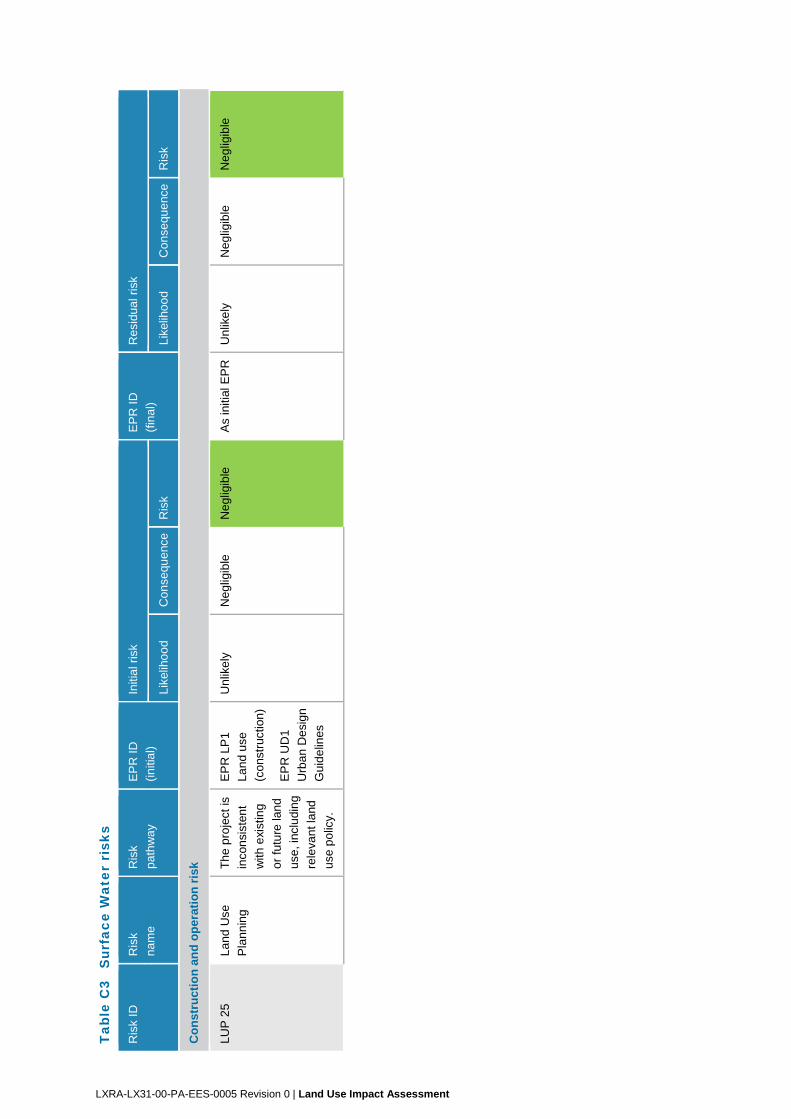
Tab
le C
3 S
urfa
ce W
ater
ris
ks
Ris
k ID
R
isk
na
me
Ris
k
pa
thw
ay
EP
R I
D
(in
itia
l)
Initi
al r
isk
EP
R I
D
(fin
al)
Re
sidu
al r
isk
Lik
elih
oo
d C
on
sequ
enc
e R
isk
Lik
elih
oo
d C
on
sequ
enc
e R
isk
Co
nst
ruct
ion
an
d o
per
atio
n r
isk
LU
P 2
5 L
an
d U
se
Pla
nn
ing
Th
e p
roje
ct is
inco
nsi
sten
t
with
exi
stin
g
or
futu
re la
nd
use
, inc
ludi
ng
rele
van
t la
nd
use
po
licy.
EP
R L
P1
La
nd
use
(co
nstr
uctio
n)
EP
R U
D1
Urb
an
De
sig
n
Gu
ide
lines
Un
like
lyN
eg
ligib
le
Ne
glig
ible
A
s in
itial
EP
R
Un
like
ly
Ne
glig
ible
N
eg
ligib
le
LXRA-LX31-00-PA-EES-0005 Revision 0 | Land Use Impact Assessment