Embed Size (px)
Citation preview
FINAL ENVIRONMENTAL IMPACT STATEMENT AND FINAL SECTION 4(f) AND 6(f) EVALUATIONS SR 520 BRIDGE REPLACEMENT AND HOV PROGRAM May 2011
SR 520, I-5 to Medina: Bridge Replacement and HOV Project
Ecosystems Discipline Report Addendum and Errata

SR 520, I-5 to Medina: Bridge Replacement and HOV Project
Final Environmental Impact Statement and Final Section 4(f) and 6(f) Evaluations
Ecosystems Discipline Report Addendum and Errata
Prepared for
Washington State Department of Transportation Federal Highway Administration
Consultant Team
Parametrix, Inc. CH2M HILL
HDR Engineering, Inc. Parsons Brinckerhoff
ICF Jones & Stokes Confluence Environmental Company, Inc.
Michael Minor and Associates PRR, Inc.
Critigen
May 2011

SR 520, I-5 to Medina: Bridge Replacement and HOV Project | Final EIS and Final Section 4(f) and 6(f) Evaluations
Contents Introduction ....................................................................................................................................................... 1
What is the purpose of this addendum? ........................................................................................... 1
What key issues were identified in the public, agency, and tribal comments on the SDEIS? ................................................................................................................................................ 1
What are the key points of this addendum?..................................................................................... 3
What is the SR 520, I-5 to Medina: Bridge Replacement and HOV Project? ................................ 8
What is the Preferred Alternative? .................................................................................................... 9
When will the project be built?......................................................................................................... 10
Are pontoons being constructed as part of this project?............................................................... 14
Wetlands ........................................................................................................................................................... 14
Affected Environment ....................................................................................................................... 14
Potential Effects .................................................................................................................................. 15
Mitigation ............................................................................................................................................ 35
Fish and Aquatic Resources .......................................................................................................................... 42
Affected Environment ....................................................................................................................... 42
Potential Effects .................................................................................................................................. 43
Mitigation ............................................................................................................................................ 78
Wildlife and Habitat ...................................................................................................................................... 83
Affected Environment ....................................................................................................................... 83
Potential Effects .................................................................................................................................. 83
Mitigation .......................................................................................................................................... 109
References ...................................................................................................................................................... 110
Attachments 1 Errata
List of Exhibits
1 Key Elements and Potential Effects on Ecosystems of the Preferred Alternative (Update to Exhibit 1-1 of the 2009 Discipline Report)
2 Preferred Alternative Project Elements
3 Preferred Alternative and Comparison to SDEIS Options
4 Preferred Alternative Construction Stages and Durations
5 Geographic Areas Along SR 520
6 Summary of Construction Effects on Wetlands by Option (Update to Exhibit 2-10 of the 2009
Discipline Report)
FEIS_ECOS_DRA_SUDS_26APR11 iii
SR 520, I-5 to Medina: Bridge Replacement and HOV Project | Final EIS and Final Section 4(f) and 6(f) Evaluations
7 Summary of Construction Effects on Wetland Buffers by Option (Update to Exhibit 2-10 of the 2009 Discipline Report)
8a Construction Effects on Wetlands and Buffers in the Portage Bay Area (Update to Exhibit 2-11a of the 2009 Discipline Report)
8b Construction Effects on Wetlands and Buffers in the West Approach Area (Update to Exhibit 2-11b of the 2009 Discipline Report)
9 Wetland and Buffer Construction Effects by Geographic Area (Update to Exhibit 2-12 of the 2009 Discipline Report)
10 Summary of Operational Effects on Wetlands by Option (Update to Exhibit 2-13 of the 2009 Discipline Report)
11 Summary of Operational Effects on Buffers by Option (Update to Exhibit 2-13 of the 2009 Discipline Report)
12a Operational Effects on Wetlands and Buffers in the Portage Bay Area (Update to Exhibit 2-14a of the 2009 Discipline Report)
12b Operational Effects on Wetlands and Buffers in the West Approach Area (Update to Exhibit 2-14b of the 2009 Discipline Report)
13 Wetland and Buffer Operational Effects by Geographic Area (Update to Exhibit 2-17 of the 2009 Discipline Report)
14 Approximate Height from the High Water Level to the Underside of Various Portions of the Bridge Structures, by Option (Update to Exhibit 2-16 of the 2009 Discipline Report)
15 Methodology Differences Between the NRTWG, Final EIS, and SDEIS
16 Wetland Mitigation Site Locations
17 Location of Affected Basins within WRIA 8
18 Open-water Shading from Construction Work Bridges, for the Preferred Alternatives and SDEIS Options (Update to Exhibit 3-9 of the 2009 Discipline Report)
19a Construction Effects of the Preferred Alternative on Aquatic Habitat (Update to Exhibit 3-10 of the 2009 Discipline Report)
19b Operational Effects of the Preferred Alternative on Aquatic Habitat (Update to Exhibit 3-10 of the 2009 Discipline Report)
20 Estimated Number of Support Piles and Associated Lakebed Occupied for the Construction Work Bridges and Falsework, for the Preferred Alternative and SDEIS Options (Update to Exhibit 3-11 of the 2009 Discipline Report)
FEIS_ECOS_DRA_SUDS_26APR11 iv
SR 520, I-5 to Medina: Bridge Replacement and HOV Project | Final EIS and Final Section 4(f) and 6(f) Evaluations
21 Potential Construction Effects of the Project on Federally ESA-Listed Fish Species in the Study Area
22 Summary Comparison of Construction Effects of the Preferred Alternative and the SDEIS Options
23 Total Area (acres) of Over-water Structure that Would Cause Operation Shading Effects (Update to Exhibit 3-17 of the 2009 Discipline Report)
24 Estimated Numbers of In-water Concrete Columns/Shafts for Portions of the Proposed Bridges and Area of Aquatic Substrate Occupied (Update to Exhibit 3-18 of the 2009 Discipline Report)
25 Net Change in Pollutant Loading from Post-Project Pollution-Generating Impervious Surface Areas (Update to Exhibit 3-20 of the Discipline Report)
26 Potential Operational Effects of the Project on Federally ESA-Listed Fish Species in the Study Area
27 Summary Comparison of Operational Effects of the Preferred Alternative and the SDEIS Options
28 Aquatic Mitigation Site Locations
29 Vegetation Removal from Construction by Cover and Habitat Type for each Option (Update to Exhibit 4-5 of the 2009 Discipline Report)
30 Construction Effects of the Preferred Alternative on Cover Type (Update to Exhibit 4-6 of the 2009 Discipline Report)
31 Construction Effects of the Preferred Alternative on Cover Type in the Eastside Area Update to Exhibit 4-7 of the 2009 Discipline Report)
32 Shading from Construction by Cover and Habitat Type for each Option (Update to Exhibit 4-9 of the 2009 Discipline Report)
33 Potential Construction Effects of the Project on Federally ESA-Listed Wildlife Species in the Study Area
34 Vegetation Removal from Operation by Cover and Habitat Type for each Option (Update to Exhibit 4-13 of the 2009 Discipline Report)
35 Operational Effects of the Preferred Alternative on Cover Type (Update to Exhibit 4-14 of the 2009 Discipline Report)
36 Operational Effects of the Preferred Alternative on Cover Type in the Eastside Area (Update to Exhibit 4-15 of the 2009 Discipline Report)
FEIS_ECOS_DRA_SUDS_26APR11 v
SR 520, I-5 to Medina: Bridge Replacement and HOV Project | Final EIS and Final Section 4(f) and 6(f) Evaluations
37 Shading from Operation by Cover and Habitat Type for each Option (Update to Exhibit 4-17 of the 2009 Discipline Report)
38 Summary of Effects from Operation of the Project on Wildlife and Habitat (Update to Exhibit 4-21 of the 2009 Discipline Report)
FEIS_ECOS_DRA_SUDS_26APR11 vi
I-5
SR 520, I-5 to Medina: Bridge Replacement and HOV Project | Final EIS and Final Section 4(f) and 6(f) Evaluations
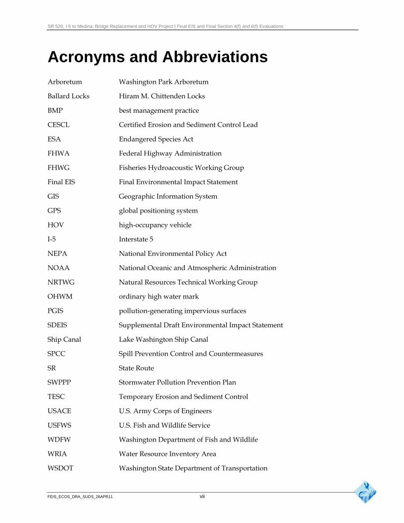
Acronyms and Abbreviations Arboretum Washington Park Arboretum
Ballard Locks Hiram M. Chittenden Locks
BMP best management practice
CESCL Certified Erosion and Sediment Control Lead
ESA Endangered Species Act
FHWA Federal Highway Administration
FHWG Fisheries Hydroacoustic Working Group
Final EIS Final Environmental Impact Statement
GIS Geographic Information System
GPS global positioning system
HOV high-occupancy vehicle
Interstate 5
NEPA National Environmental Policy Act
NOAA National Oceanic and Atmospheric Administration
NRTWG Natural Resources Technical Working Group
OHWM ordinary high water mark
PGIS pollution-generating impervious surfaces
SDEIS Supplemental Draft Environmental Impact Statement
Ship Canal Lake Washington Ship Canal
SPCC Spill Prevention Control and Countermeasures
SR State Route
SWPPP Stormwater Pollution Prevention Plan
TESC Temporary Erosion and Sediment Control
USACE U.S. Army Corps of Engineers
USFWS U.S. Fish and Wildlife Service
WDFW Washington Department of Fish and Wildlife
WRIA Water Resource Inventory Area
WSDOT Washington State Department of Transportation
FEIS_ECOS_DRA_SUDS_26APR11 vii

SR 520, I-5 to Medina: Bridge Replacement and HOV Project | Final EIS and Final Section 4(f) and 6(f) Evaluations
Introduction
What is the purpose of this addendum?
This addendum to the State Route (SR) 520, I-5 to Medina: Bridge Replacement and High-Occupancy Vehicle (HOV) Project Supplemental Draft Environmental Impact Statement (SDEIS) Ecosystems Discipline Report (Washington State Department of Transportation [WSDOT] 2009a) presents the environmental consequences of the Preferred Alternative, compares its effects on the design options A, K, and L, and reflects additional analyses that resulted from the public, agency, and tribal comments received on the SDEIS; these analyses are shown in the context of the Preferred Alternative. Additional design information has become available since the publication of the SDEIS. This design information has been used to develop the Preferred Alternative; however, many of the design changes would also be applicable to the SDEIS Options A, K, and L if they were identified as the Preferred Alternative.
The information contained in the 2009 Ecosystems Discipline Report (WSDOT 2009a) is still pertinent to the Preferred Alternative and its effects, except where this addendum specifically updates it. The discussion below supplements the 2009 Ecosystems Discipline Report and provides comparisons using new text, and new or updated exhibits, where appropriate. New exhibits updated to reflect the Preferred Alternative have been cross-referenced by page numbers and exhibit numbers to related text and exhibits contained within the 2009 Ecosystems Discipline Report. Where an addendum exhibit updates or adds new data and/or different potential effects on an exhibit contained in the Ecosystems Discipline Report, the exhibit name is followed by “update to Exhibit ##” in parentheses.
New information used in the analysis of potential effects includes the Description of Alternatives Discipline Report Addendum (WSDOT 2011a), Construction Techniques and Activities Discipline Report Addendum and Errata (WSDOT 2011b), Water Resources Discipline Report Addendum and Errata (WSDOT 2011c), and the Noise Discipline Report Addendum and Errata (WSDOT 2011d). New information, the Conceptual Wetland Mitigation Report (WSDOT 2011e), and the Conceptual Aquatic Mitigation Plan (WSDOT 2011f) were used in determining mitigation measures.
An errata sheet is attached to this addendum (Attachment 1) to show corrections to the 2009 Ecosystems Discipline Report that do not constitute new findings or analysis.
What key issues were identified in the public, agency, and tribal comments on the SDEIS?
Key issues identified in public comments and addressed in this addendum include:
FEIS_ECOS_DRA_SUDS_26APR11 1
SR 520, I-5 to Medina: Bridge Replacement and HOV Project | Final EIS and Final Section 4(f) and 6(f) Evaluations
Wetlands
Requests to clarify potential effects from shading
Requests to increase bridge height to offset shading effects
Requests to provide additional mitigation information
Recommendations to provide mitigation onsite, if possible, and within the Union Bay area
Requests that effects on the Washington Park Arboretum (Arboretum) be mitigated in the Arboretum to the extent feasible
Request that WSDOT should work more collaboratively with agencies and tribes
Aquatic Resources
Requests to more thoroughly address construction effects on adult salmon
Requests to provide more information to assess the extent that high water temperature in the Lake Washington Ship Canal (Ship Canal) influences adult salmon and how the SR 520, I-5 to Medina project would affect salmonid migration
Requests to include more discussion concerning the risk of predation associated with in-water and over-water structures
Requests to consider reducing or eliminating nighttime lighting on water surfaces to minimize effects on salmonids
Requests to minimize aquatic effects associated with the bridge maintenance facility
Concerns that pile-driving and associated noise would have substantial negative effects on fish species
Requests to reduce shading effects on aquatic resources
Wildlife
Requests to minimize pile-driving and construction near the Broadmoor eagle pair nest site
Concerns that construction and operation would negatively affect the wildlife and habitat in the Arboretum
Requests to mitigate permanent loss of wildlife habitat even though it is not required by regulation
Requests to include the Union Bay Natural Area in the analysis, even if only to state that there is no effect
FEIS_ECOS_DRA_SUDS_26APR11 2
SR 520, I-5 to Medina: Bridge Replacement and HOV Project | Final EIS and Final Section 4(f) and 6(f) Evaluations
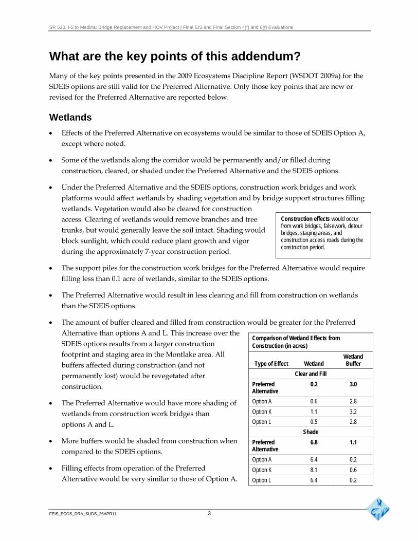
What are the key points of this addendum?
Many of the key points presented in the 2009 Ecosystems Discipline Report (WSDOT 2009a) for the SDEIS options are still valid for the Preferred Alternative. Only those key points that are new or revised for the Preferred Alternative are reported below.
Wetlands
Effects of the Preferred Alternative on ecosystems would be similar to those of SDEIS Option A, except where noted.
Some of the wetlands along the corridor would be permanently and/or filled during construction, cleared, or shaded under the Preferred Alternative and the SDEIS options.
Under the Preferred Alternative and the SDEIS options, construction work bridges and work platforms would affect wetlands by shading vegetation and by bridge support structures filling wetlands. Vegetation would also be cleared for construction access. Clearing of wetlands would remove branches and tree Construction effects would occur
from work bridges, falsework, detour trunks, but would generally leave the soil intact. Shading would bridges, staging areas, and block sunlight, which could reduce plant growth and vigor construction access roads during the
construction period. during the approximately 7-year construction period.
The support piles for the construction work bridges for the Preferred Alternative would require filling less than 0.1 acre of wetlands, similar to the SDEIS options.
The Preferred Alternative would result in less clearing and fill from construction on wetlands than the SDEIS options.
The amount of buffer cleared and filled from construction would be greater for the Preferred Alternative than options A and L. This increase over the SDEIS options results from a larger construction footprint and staging area in the Montlake area. All buffers affected during construction (and not permanently lost) would be revegetated after construction.
The Preferred Alternative would have more shading of wetlands from construction work bridges than options A and L.
More buffers would be shaded from construction when compared to the SDEIS options.
Filling effects from operation of the Preferred Alternative would be very similar to those of Option A.
Comparison of Wetland Effects from Construction (in acres)
Type of Effect Wetland Wetland Buffer
Clear and Fill
Preferred Alternative
0.2 3.0
Option A 0.6 2.8
Option K 1.1 3.2
Option L 0.5 2.8
Shade
Preferred Alternative
6.8 1.1
Option A 6.4 0.2
Option K 8.1 0.6
Option L 6.4 0.2
FEIS_ECOS_DRA_SUDS_26APR11 3
SR 520, I-5 to Medina: Bridge Replacement and HOV Project | Final EIS and Final Section 4(f) and 6(f) Evaluations
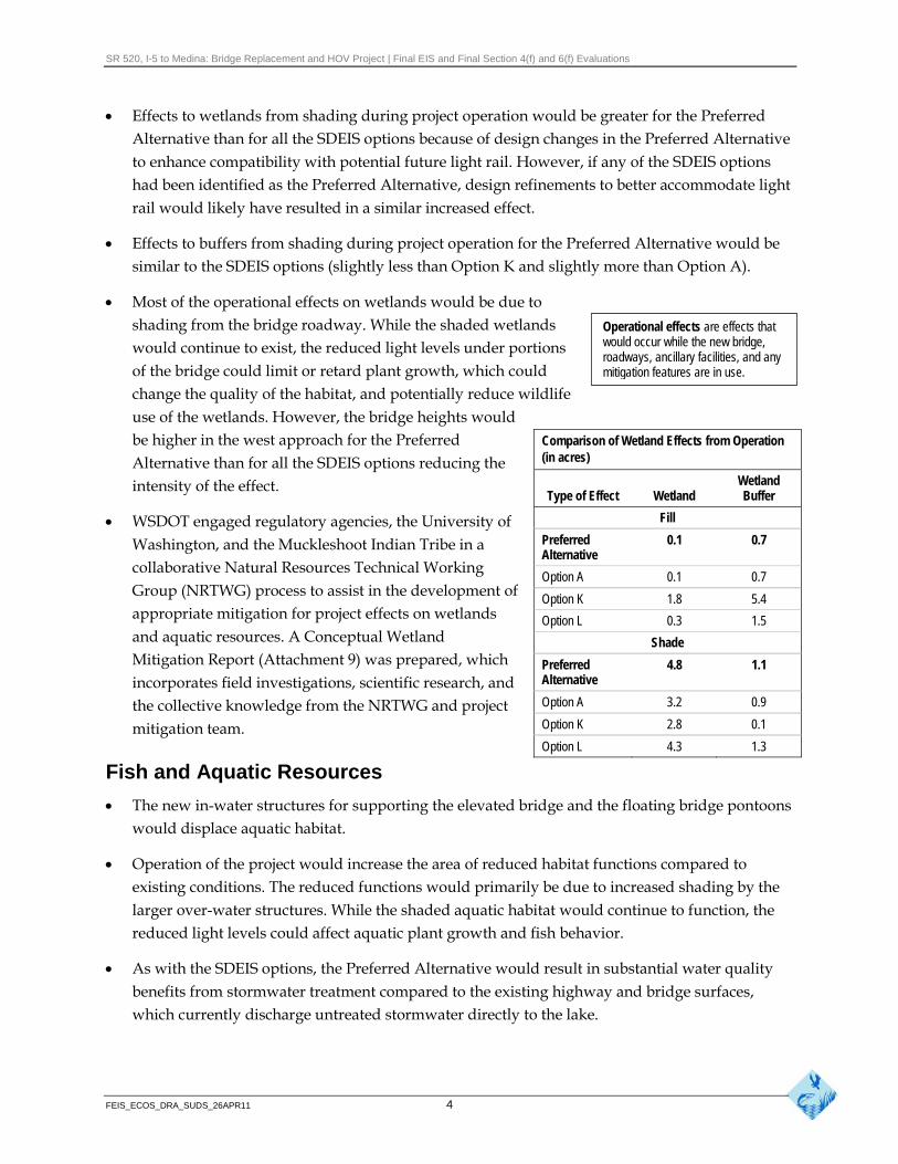
Effects to wetlands from shading during project operation would be greater for the Preferred Alternative than for all the SDEIS options because of design changes in the Preferred Alternative to enhance compatibility with potential future light rail. However, if any of the SDEIS options had been identified as the Preferred Alternative, design refinements to better accommodate light rail would likely have resulted in a similar increased effect.
Effects to buffers from shading during project operation for the Preferred Alternative would be similar to the SDEIS options (slightly less than Option K and slightly more than Option A).
Most of the operational effects on wetlands would be due to shading from the bridge roadway. While the shaded wetlands Operational effects are effects that
would occur while the new bridge,would continue to exist, the reduced light levels under portions roadways, ancillary facilities, and any
of the bridge could limit or retard plant growth, which could mitigation features are in use.
change the quality of the habitat, and potentially reduce wildlife use of the wetlands. However, the bridge heights would be higher in the west approach for the Preferred Alternative than for all the SDEIS options reducing the intensity of the effect.
WSDOT engaged regulatory agencies, the University of Washington, and the Muckleshoot Indian Tribe in a collaborative Natural Resources Technical Working Group (NRTWG) process to assist in the development of appropriate mitigation for project effects on wetlands and aquatic resources. A Conceptual Wetland Mitigation Report (Attachment 9) was prepared, which incorporates field investigations, scientific research, and the collective knowledge from the NRTWG and project mitigation team.
Comparison of Wetland Effects from Operation (in acres)
Type of Effect Wetland Wetland Buffer
Fill
Preferred Alternative
0.1 0.7
Option A 0.1 0.7
Option K 1.8 5.4
Option L 0.3 1.5
Shade
Preferred Alternative
4.8 1.1
Option A 3.2 0.9
Option K 2.8 0.1
Option L 4.3 1.3
Fish and Aquatic Resources
The new in-water structures for supporting the elevated bridge and the floating bridge pontoons would displace aquatic habitat.
Operation of the project would increase the area of reduced habitat functions compared to existing conditions. The reduced functions would primarily be due to increased shading by the larger over-water structures. While the shaded aquatic habitat would continue to function, the reduced light levels could affect aquatic plant growth and fish behavior.
As with the SDEIS options, the Preferred Alternative would result in substantial water quality benefits from stormwater treatment compared to the existing highway and bridge surfaces, which currently discharge untreated stormwater directly to the lake.
FEIS_ECOS_DRA_SUDS_26APR11 4
SR 520, I-5 to Medina: Bridge Replacement and HOV Project | Final EIS and Final Section 4(f) and 6(f) Evaluations
Most of the proposed bridge structures for the Preferred Alternative would be similar in height or higher than the existing bridge structures. The higher sections would partially offset the potential shading effects of the wider structures, while the effects would likely be substantially greater for those sections that remain at about the same height as the existing structures because of the increased roadway width.
Shading over shallow, nearshore habitats, including Portage Bay, Union Bay, and the Arboretum, would likely have greater potential effects than shading in the deeper, open lake environment. The nearshore generally provides areas of greater habitat complexity to support a diverse biological community. Therefore, increased shading in these areas would have a greater potential to affect a variety of species, such as altering fish behavior or habitat use. However, shading could also reduce the densities of invasive aquatic vegetation, which could result in slight improvements to water quality conditions and fish habitat use.
Both the permanent and construction structures would require pile-driving and other in-water construction activities. Pile-driving could affect nearby fish behavior or potentially cause fish mortality from the high sound pressure levels from impact pile-driving hammers. Appropriate and available construction best management practices (BMPs) would be used to minimize the effects of pile-driving. These BMPs have been demonstrated through a project-specific test pile study to substantially reduce pile-driving sound levels in the aquatic environment. Fish habitat could also be affected by temporary increases in turbidity and shade; moreover, habitat would be lost due to pile placement for construction work structures.
Construction of the maintenance facility may increase groundwater drawdown, which may reduce upwelling in the sockeye spawning habitat area. Effects on upwelling pressure may affect sockeye spawning habitat.
Implementing erosion and sediment control measures, spill prevention plans, and other BMPs would minimize construction effects. After construction of the project, the temporarily affected aquatic habitat areas would be restored or would recover naturally.
In cooperation with resource agencies, WSDOT is developing plans for habitat construction, improvements, or restoration to mitigate the effects of bridge construction, the increased width of shoreline and open-water crossings, and direct physical effects from construction activities. A mitigation report has been included as an attachment to the Final Environmental Impact Statement (EIS). In addition, a detailed mitigation plan will be submitted with permit applications for the SR 520, I-5 to Medina project.
Based on existing data, it is not expected that the longer and deeper pontoon bridge section of the Preferred Alternative would substantially alter the lake circulation patterns or limnological processes relative to existing conditions.
FEIS_ECOS_DRA_SUDS_26APR11 5
SR 520, I-5 to Medina: Bridge Replacement and HOV Project | Final EIS and Final Section 4(f) and 6(f) Evaluations
The decrease in the number of in-water support columns and increased spacing between the columns in the Preferred Alternative compared to existing conditions are expected to reduce predator fish habitat and predation on juvenile salmon.
The Preferred Alternative, like the SDEIS options, is not expected to measurably affect adult salmon.
Wildlife and Habitat
The Preferred Alternative would affect wildlife habitat and potential wildlife use by permanently removing vegetation, increasing shading, and reducing barriers to animal movement. Specific effects on wildlife would vary throughout the corridor.
The new roadway would displace some high-quality wildlife habitat principally wetlands and forested uplands in the project corridor. The roadway would reduce cover, nesting, and foraging habitat for some species.
The Preferred Alternative would include taller concrete traffic barriers treated with noise-absorptive material and quieter concrete pavement, along with other innovative noise reduction strategies that would reduce disturbance in the adjacent habitats. Noise from construction activities and pile-driving could potentially affect bird species, including nesting (the most sensitive life cycle) bald eagles near the Arboretum. However, the closest known bald eagle nest would be more than 900 feet from the construction corridor and noise levels would be close to background levels at this distance. In addition, bald eagles regularly forage and roost in proximity to the SR 520 corridor, especially in the winter, and do not seem to be affected by existing noise from SR 520.
Transport of the pontoons is not likely to affect marine wildlife found in the waters of the outer Washington coast, the Strait of Juan de Fuca, and Puget Sound.
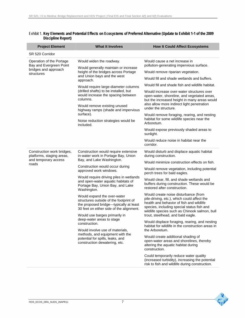
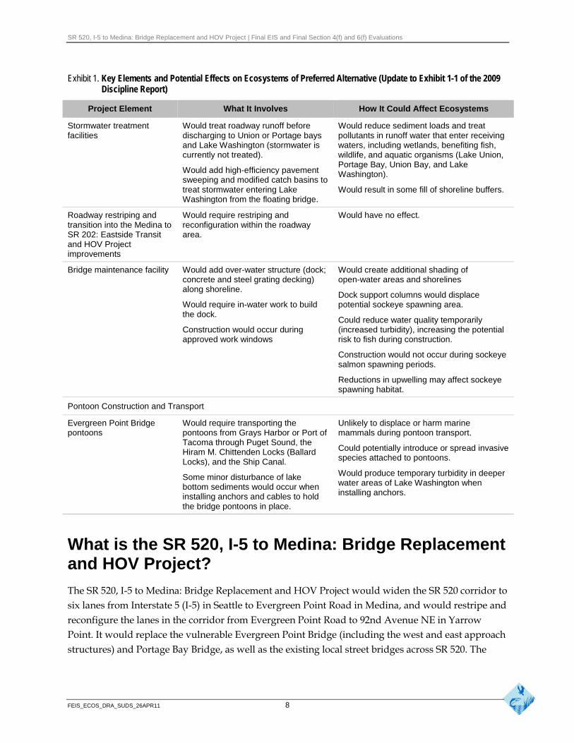
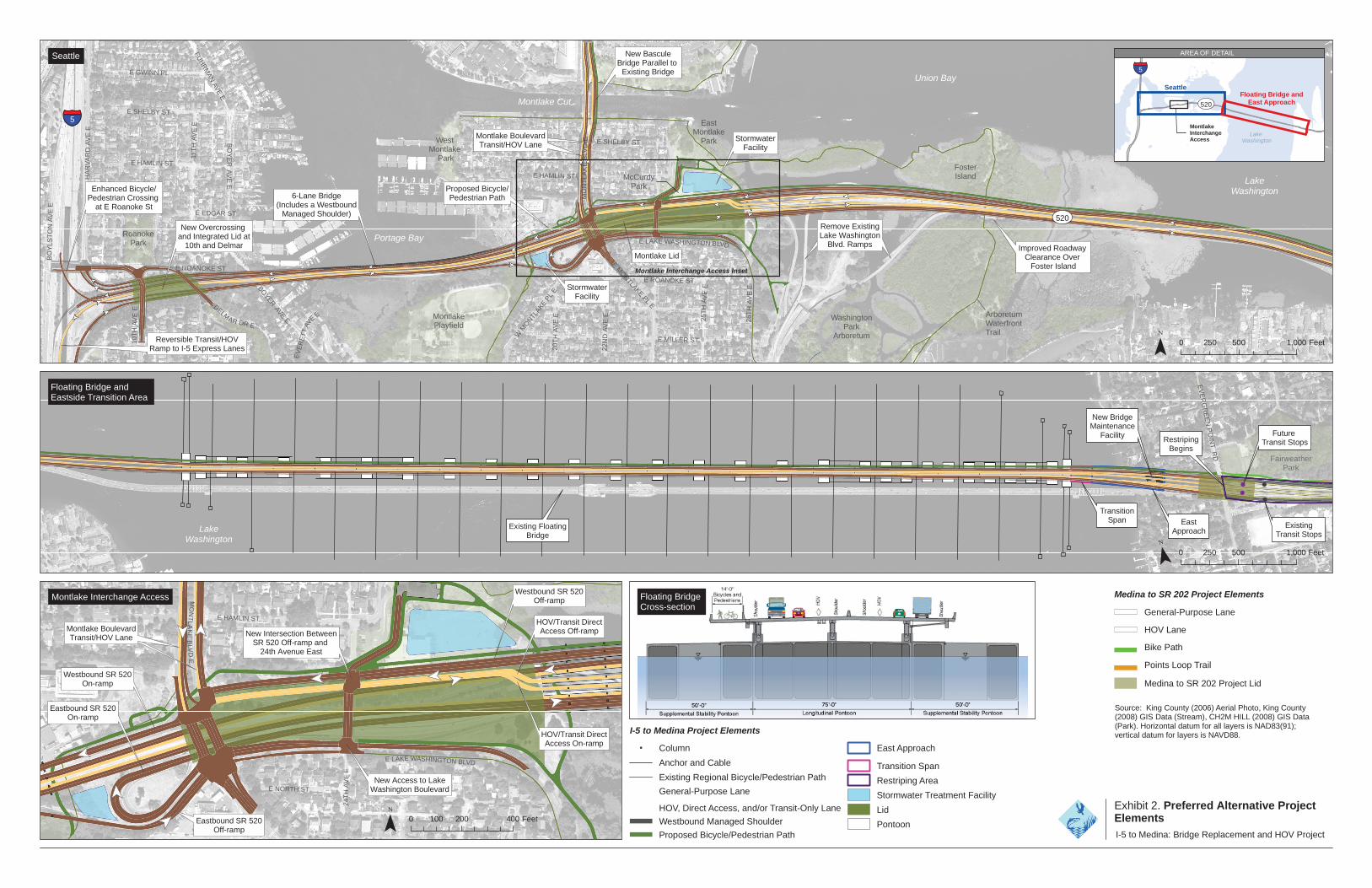
The key elements of the Preferred Alternative with the potential to affect ecosystem resources in the study area are summarized in Exhibit 1.
FEIS_ECOS_DRA_SUDS_26APR11 6
SR 520, I-5 to Medina: Bridge Replacement and HOV Project | Final EIS and Final Section 4(f) and 6(f) Evaluations
Exhibit 1. Key Elements and Potential Effects on Ecosystems of Preferred Alternative (Update to Exhibit 1-1 of the 2009 Discipline Report)
Project Element What It Involves How It Could Affect Ecosystems
SR 520 Corridor
Operation of the Portage Bay and Evergreen Point bridges and approach structures
Would widen the roadway.
Would generally maintain or increase height of the bridges across Portage and Union bays and the west approach.
Would require large-diameter columns (drilled shafts) to be installed, but would increase the spacing between columns.
Would remove existing unused highway ramps (shade and impervious surface).
Noise reduction strategies would be included.
Would cause a net increase in pollution-generating impervious surface.
Would remove riparian vegetation.
Would fill and shade wetlands and buffers.
Would fill and shade fish and wildlife habitat.
Would increase over-water structures over open-water, shoreline, and vegetated areas, but the increased height in many areas would also allow more indirect light penetration under the structure.
Would remove foraging, rearing, and nesting habitat for some wildlife species near the Arboretum.
Would expose previously shaded areas to sunlight.
Would reduce noise in habitat near the corridor.
Construction work bridges, platforms, staging areas, and temporary access roads
Construction would require extensive in-water work in Portage Bay, Union Bay, and Lake Washington.
Construction would occur during approved work windows.
Would require driving piles in wetlands and open-water aquatic habitats of Portage Bay, Union Bay, and Lake Washington.
Would expand the over-water structures outside of the footprint of the proposed bridge—typically at least 30 feet on either side of the alignment.
Would use barges primarily in deep-water areas to stage construction.
Would involve use of materials, methods, and equipment with the potential for spills, leaks, and construction dewatering, etc.
Would disturb and displace aquatic habitat during construction.
Would minimize construction effects on fish.
Would remove vegetation, including potential perch trees for bald eagles.
Would clear, fill, and shade wetlands and buffers during construction. These would be restored after construction.
Would create noise disturbance (from pile-driving, etc.), which could affect the health and behavior of fish and wildlife species, including special status fish and wildlife species such as Chinook salmon, bull trout, steelhead, and bald eagle.
Would displace foraging, rearing, and nesting habitat for wildlife in the construction areas in the Arboretum.
Would create additional shading of open-water areas and shorelines, thereby altering the aquatic habitat during construction.
Could temporarily reduce water quality (increased turbidity), increasing the potential risk to fish and wildlife during construction.
FEIS_ECOS_DRA_SUDS_26APR11 7
SR 520, I-5 to Medina: Bridge Replacement and HOV Project | Final EIS and Final Section 4(f) and 6(f) Evaluations
Exhibit 1. Key Elements and Potential Effects on Ecosystems of Preferred Alternative (Update to Exhibit 1-1 of the 2009 Discipline Report)
Project Element What It Involves How It Could Affect Ecosystems
Stormwater treatment facilities
Would treat roadway runoff before discharging to Union or Portage bays and Lake Washington (stormwater is currently not treated).
Would add high-efficiency pavement sweeping and modified catch basins to treat stormwater entering Lake Washington from the floating bridge.
Would reduce sediment loads and treat pollutants in runoff water that enter receiving waters, including wetlands, benefiting fish, wildlife, and aquatic organisms (Lake Union, Portage Bay, Union Bay, and Lake Washington).
Would result in some fill of shoreline buffers.
Roadway restriping and Would require restriping and Would have no effect. transition into the Medina to reconfiguration within the roadway SR 202: Eastside Transit area. and HOV Project improvements
Bridge maintenance facility Would add over-water structure (dock; concrete and steel grating decking) along shoreline.
Would require in-water work to build the dock.
Construction would occur during approved work windows
Pontoon Construction and Transport
Would create additional shading of open-water areas and shorelines
Dock support columns would displace potential sockeye spawning area.
Could reduce water quality temporarily (increased turbidity), increasing the potential risk to fish during construction.
Construction would not occur during sockeye salmon spawning periods.
Reductions in upwelling may affect sockeye spawning habitat.
Evergreen Point Bridge pontoons
Would require transporting the pontoons from Grays Harbor or Port of Tacoma through Puget Sound, the Hiram M. Chittenden Locks (Ballard Locks), and the Ship Canal.
Some minor disturbance of lake bottom sediments would occur when installing anchors and cables to hold the bridge pontoons in place.
Unlikely to displace or harm marine mammals during pontoon transport.
Could potentially introduce or spread invasive species attached to pontoons.
Would produce temporary turbidity in deeper water areas of Lake Washington when installing anchors.
What is the SR 520, I-5 to Medina: Bridge Replacement and HOV Project?
The SR 520, I-5 to Medina: Bridge Replacement and HOV Project would widen the SR 520 corridor to six lanes from Interstate 5 (I-5) in Seattle to Evergreen Point Road in Medina, and would restripe and reconfigure the lanes in the corridor from Evergreen Point Road to 92nd Avenue NE in Yarrow Point. It would replace the vulnerable Evergreen Point Bridge (including the west and east approach structures) and Portage Bay Bridge, as well as the existing local street bridges across SR 520. The
FEIS_ECOS_DRA_SUDS_26APR11 8

SR 520, I-5 to Medina: Bridge Replacement and HOV Project | Final EIS and Final Section 4(f) and 6(f) Evaluations
project would complete the regional HOV lane system across SR 520, as called for in regional and local transportation plans.
What is the Preferred Alternative?
The new SR 520 corridor would be six lanes wide (two 11-foot-wide outer general-purpose lanes and one 12-foot-wide inside HOV lane in each direction), with 4-foot-wide inside shoulders and 10-foot-wide outside shoulders across the floating bridge. The typical roadway cross-section across the floating bridge would be approximately 116 feet wide, compared to the existing width of 60 feet. In response to community interests expressed during public review of the January 2010 SDEIS, the SR 520 corridor between I-5 and the Montlake interchange would operate as a boulevard or parkway with a posted speed limit of 45 miles per hour and median planting across the Portage Bay Bridge. To support the boulevard concept, the width of the inside shoulders in this section of SR 520 would be narrowed from 4 feet to 2 feet, and the width of the outside shoulders would be reduced from 10 feet to 8 feet. Exhibit 2 highlights the major components of the Preferred Alternative.
The Preferred Alternative would include the following elements:
An enhanced bicycle/pedestrian crossing adjacent to the East Roanoke Street bridge over I-5
Reversible transit/HOV ramp to the I-5 express lanes, southbound in the morning and northbound in the evening
New undercrossings and an integrated lid at 10th Avenue East and Delmar Drive East
A six-lane Portage Bay Bridge with a 14-foot-wide westbound managed shoulder that would be used as an auxiliary lane during peak commute hours
An improved urban interchange at Montlake Boulevard integrated with a 1,400-foot-long lid configured for transit, pedestrian, and community connectivity
A new bascule bridge across the Montlake Cut that provides additional capacity for transit/HOV, bicycles, and pedestrians
Improved bridge clearance over Foster Island and the Arboretum Waterfront Trail
A new west approach bridge configured to be compatible with future high-capacity transit (including light rail)
A new floating bridge with two general-purpose lanes, and one HOV lane in each direction
A new 14-foot-wide bicycle/pedestrian path with scenic pull-outs along the north side of the new Evergreen Point Bridge (west approach, floating span, and east approach), connecting regional trails on both sides of Lake Washington
A new bridge maintenance facility and dock located underneath the east approach of the Evergreen Point Bridge
FEIS_ECOS_DRA_SUDS_26APR11 9
SR 520, I-5 to Medina: Bridge Replacement and HOV Project | Final EIS and Final Section 4(f) and 6(f) Evaluations
Re-striped and reconfigured roadway between the east approach and 92nd Avenue NE, tying in to improvements made by the SR 520, Medina to SR 202: Eastside Transit and HOV Project
Design features that would also provide noise reduction including reduced speed limit on Portage Bay Bridge, 4-foot concrete traffic barriers, and noise absorptive materials applied to the inside of the 4-foot traffic barriers and lid portals. Quieter concrete pavement would also be used for the new SR 520 main line, and noise walls where recommended by the noise analysis and approved by affected property owners would be included in the design
Basic and enhanced stormwater treatment facilities
Exhibit 3 summarizes the Preferred Alternative design compared to the existing corridor elements, and compares the Preferred Alternative to design options A, K, and L as described in the SDEIS. For a more detailed description of the Preferred Alternative, see the Description of Alternatives Discipline Report Addendum (WSDOT 2011a).
When will the project be built?
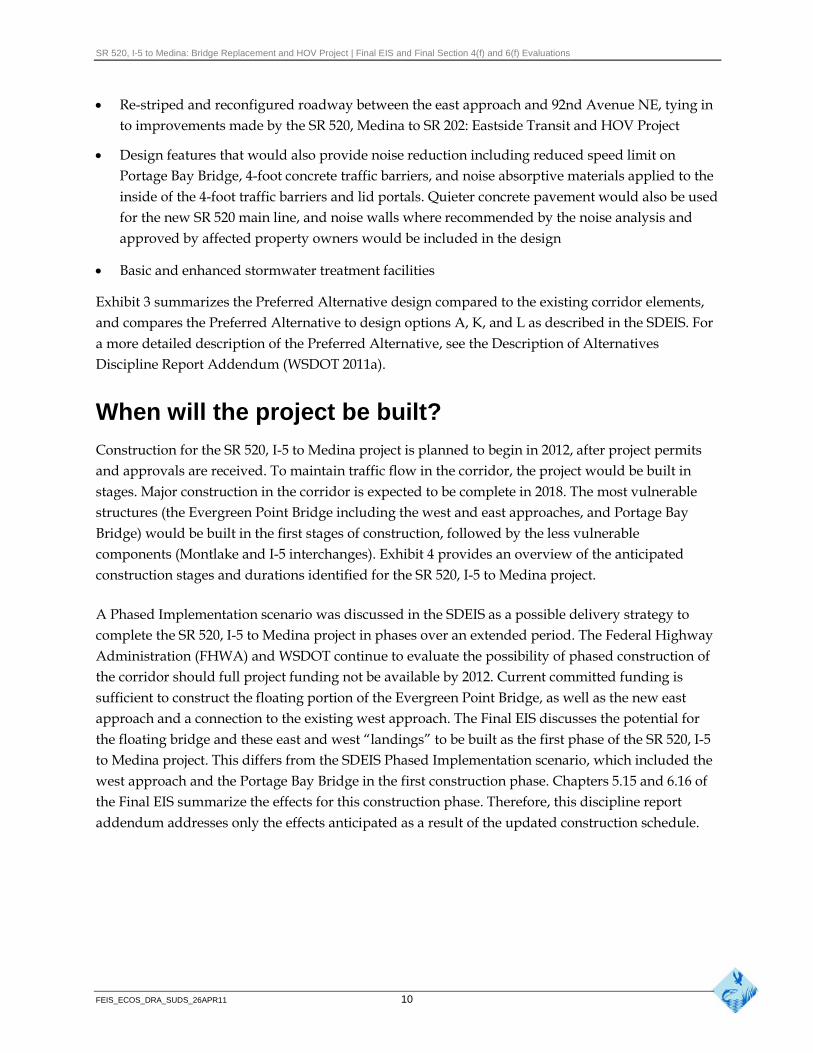
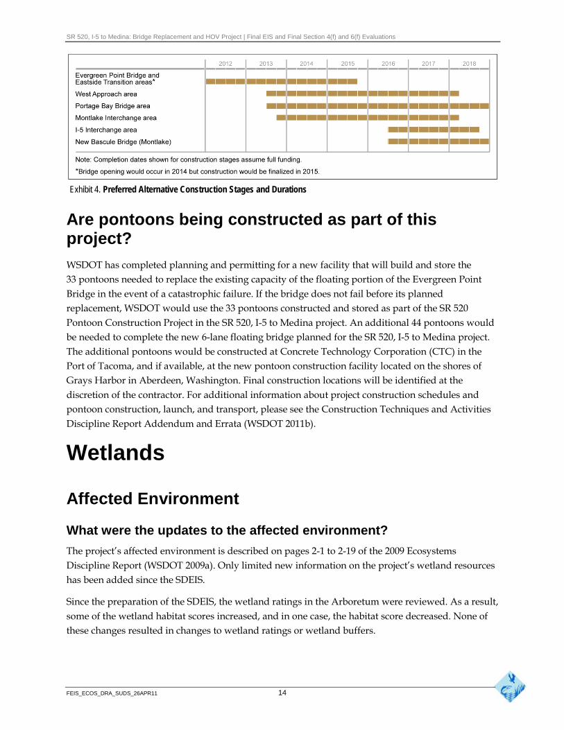
Construction for the SR 520, I-5 to Medina project is planned to begin in 2012, after project permits and approvals are received. To maintain traffic flow in the corridor, the project would be built in stages. Major construction in the corridor is expected to be complete in 2018. The most vulnerable structures (the Evergreen Point Bridge including the west and east approaches, and Portage Bay Bridge) would be built in the first stages of construction, followed by the less vulnerable components (Montlake and I-5 interchanges). Exhibit 4 provides an overview of the anticipated construction stages and durations identified for the SR 520, I-5 to Medina project.
A Phased Implementation scenario was discussed in the SDEIS as a possible delivery strategy to complete the SR 520, I-5 to Medina project in phases over an extended period. The Federal Highway Administration (FHWA) and WSDOT continue to evaluate the possibility of phased construction of the corridor should full project funding not be available by 2012. Current committed funding is sufficient to construct the floating portion of the Evergreen Point Bridge, as well as the new east approach and a connection to the existing west approach. The Final EIS discusses the potential for the floating bridge and these east and west “landings” to be built as the first phase of the SR 520, I-5 to Medina project. This differs from the SDEIS Phased Implementation scenario, which included the west approach and the Portage Bay Bridge in the first construction phase. Chapters 5.15 and 6.16 of the Final EIS summarize the effects for this construction phase. Therefore, this discipline report addendum addresses only the effects anticipated as a result of the updated construction schedule.
FEIS_ECOS_DRA_SUDS_26APR11 10
Enhanced Bicycle/ Pedestrian Crossing
at E Roanoke St
§̈¦5
UV520
Lake Washington
Portage Bay
Montlake Cut
Union Bay
West Montlake
Park
Montlake Playfield
East Montlake
Park
Washington Park
Arboretum
McCurdy Park
Arboretum Waterfront Trail
Foster Island
Roanoke Park
Proposed Bicycle/ Pedestrian Path
Stormwater Facility
Stormwater Facility
Montlake Lid
6-Lane Bridge (Includes a Westbound
Managed Shoulder)
New Bascule Bridge Parallel to
Existing Bridge
Montlake Boulevard Transit/HOV Lane
Remove Existing Lake Washington
Blvd. Ramps
Montlake Interchange Access Inset
Reversible Transit/HOV Ramp to I-5 Express Lanes
New Overcrossing and Integrated Lid at
10th and Delmar Improved Roadway Clearance Over
Foster Island
DELMAR DR E
BOYER
AVEE
E HAMLIN ST
E ROANOKE ST
E EDGAR ST
25T
H A
VE
E
FUH
RM
AN
AVE
E
E SHELBY ST
E HAMLIN ST
WM
ON
TLAKE
PLE
EM
ONTLAKE
PLE
20
TH
AV
E E
E ROANOKE ST
22
ND
AV
E E
EV
ER
ET
TAV
EE
HA
RV
AR
D A
VE
E
E MILLER ST10
TH
AV
E E
11T
H A
VE
E
26T
H A
VE
E
E LAKE WASHINGTON BLVD
E SHELBY ST
E GWINN PL
MO
NT
LA
KE
BL V
D E
BO
YL
ST
ON
AV
E E
BO
YE
R A
VE
E
I-5 to Medina: Bridge Replacement and HOV Project
Exhibit 2. Preferred Alternative Project Elements
I-5 to Medina Project Elements
! Column
Anchor and Cable
Existing Regional Bicycle/Pedestrian Path
General-Purpose Lane
HOV, Direct Access, and/or Transit-Only Lane
Westbound Managed Shoulder
Proposed Bicycle/Pedestrian Path
East Approach
Transition Span
Restriping Area
Stormwater Treatment Facility
Lid
Pontoon
¯ 0 500 1,000 250 Feet
Seattle
Lake Washington
EV
ER
GR
EE
NP
OIN
T R
D
Fairweather Park
New Bridge Maintenance
Facility Restriping Begins
Transition Span East
Approach
Future Transit Stops
Existing Transit Stops
Existing Floating Bridge
¯ Medina to SR 202 Project Elements
General-Purpose Lane
HOV Lane
Bike Path
Points Loop Trail
Medina to SR 202 Project Lid
Lake Washington
UV520
§̈¦5
Seattle Floating Bridge and
East Approach
Montlake Interchange Access
AREA OF DETAIL
Source: King County (2006) Aerial Photo, King County (2008) GIS Data (Stream), CH2M HILL (2008) GIS Data (Park). Horizontal datum for all layers is NAD83(91); vertical datum for layers is NAVD88.
Westbound SR 520 On-ramp
Eastbound SR 520 Off-ramp
Eastbound SR 520 On-ramp
Westbound SR 520 Off-ramp
HOV/Transit Direct Access Off-ramp
HOV/Transit Direct Access On-ramp
New Access to Lake Washington Boulevard
New Intersection Between SR 520 Off-ramp and
24th Avenue East
Montlake Boulevard Transit/HOV Lane
24T
HA
VE
E
MO
NT
LA
KE
BLV
D E
E HAMLIN ST
E NORTH ST
E LAKE WASHINGTON BLVD
Montlake Interchange Access
Floating Bridge and Eastside Transition Area
0 500 1,000 250 Feet
¯ 0 200 400 100 Feet
Floating Bridge Cross-section

SR 520, I-5 to Medina: Bridge Replacement and HOV Project | Final EIS and Final Section 4(f) and 6(f) Evaluations
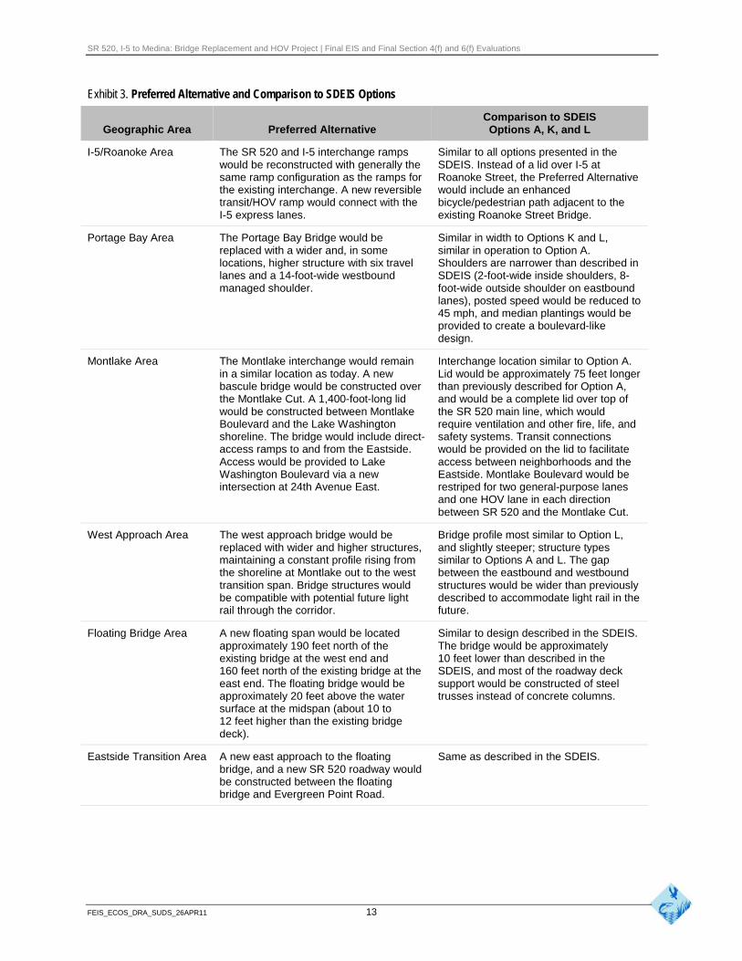
Exhibit 3. Preferred Alternative and Comparison to SDEIS Options
Geographic Area Preferred Alternative
I-5/Roanoke Area The SR 520 and I-5 interchange ramps would be reconstructed with generally the same ramp configuration as the ramps for the existing interchange. A new reversible transit/HOV ramp would connect with the I-5 express lanes.
Comparison to SDEIS Options A, K, and L
Similar to all options presented in the SDEIS. Instead of a lid over I-5 at Roanoke Street, the Preferred Alternative would include an enhanced bicycle/pedestrian path adjacent to the existing Roanoke Street Bridge.
Portage Bay Area The Portage Bay Bridge would be replaced with a wider and, in some locations, higher structure with six travel lanes and a 14-foot-wide westbound managed shoulder.
Similar in width to Options K and L, similar in operation to Option A. Shoulders are narrower than described in SDEIS (2-foot-wide inside shoulders, 8-foot-wide outside shoulder on eastbound lanes), posted speed would be reduced to 45 mph, and median plantings would be provided to create a boulevard-like design.
Montlake Area The Montlake interchange would remain in a similar location as today. A new bascule bridge would be constructed over the Montlake Cut. A 1,400-foot-long lid would be constructed between Montlake Boulevard and the Lake Washington shoreline. The bridge would include direct-access ramps to and from the Eastside. Access would be provided to Lake Washington Boulevard via a new intersection at 24th Avenue East.
Interchange location similar to Option A. Lid would be approximately 75 feet longer than previously described for Option A, and would be a complete lid over top of the SR 520 main line, which would require ventilation and other fire, life, and safety systems. Transit connections would be provided on the lid to facilitate access between neighborhoods and the Eastside. Montlake Boulevard would be restriped for two general-purpose lanes and one HOV lane in each direction between SR 520 and the Montlake Cut.
West Approach Area The west approach bridge would be replaced with wider and higher structures, maintaining a constant profile rising from the shoreline at Montlake out to the west transition span. Bridge structures would be compatible with potential future light rail through the corridor.
Bridge profile most similar to Option L, and slightly steeper; structure types similar to Options A and L. The gap between the eastbound and westbound structures would be wider than previously described to accommodate light rail in the future.
Floating Bridge Area A new floating span would be located Similar to design described in the SDEIS. approximately 190 feet north of the The bridge would be approximately existing bridge at the west end and 10 feet lower than described in the 160 feet north of the existing bridge at the SDEIS, and most of the roadway deck east end. The floating bridge would be support would be constructed of steel approximately 20 feet above the water trusses instead of concrete columns. surface at the midspan (about 10 to 12 feet higher than the existing bridge deck).
Eastside Transition Area A new east approach to the floating Same as described in the SDEIS. bridge, and a new SR 520 roadway would be constructed between the floating bridge and Evergreen Point Road.
FEIS_ECOS_DRA_SUDS_26APR11 13
SR 520, I-5 to Medina: Bridge Replacement and HOV Project | Final EIS and Final Section 4(f) and 6(f) Evaluations
Exhibit 4. Preferred Alternative Construction Stages and Durations
Are pontoons being constructed as part of this project?
WSDOT has completed planning and permitting for a new facility that will build and store the 33 pontoons needed to replace the existing capacity of the floating portion of the Evergreen Point Bridge in the event of a catastrophic failure. If the bridge does not fail before its planned replacement, WSDOT would use the 33 pontoons constructed and stored as part of the SR 520 Pontoon Construction Project in the SR 520, I-5 to Medina project. An additional 44 pontoons would be needed to complete the new 6-lane floating bridge planned for the SR 520, I-5 to Medina project. The additional pontoons would be constructed at Concrete Technology Corporation (CTC) in the Port of Tacoma, and if available, at the new pontoon construction facility located on the shores of Grays Harbor in Aberdeen, Washington. Final construction locations will be identified at the discretion of the contractor. For additional information about project construction schedules and pontoon construction, launch, and transport, please see the Construction Techniques and Activities Discipline Report Addendum and Errata (WSDOT 2011b).
Wetlands
Affected Environment
What were the updates to the affected environment?
The project’s affected environment is described on pages 2-1 to 2-19 of the 2009 Ecosystems Discipline Report (WSDOT 2009a). Only limited new information on the project’s wetland resources has been added since the SDEIS.
Since the preparation of the SDEIS, the wetland ratings in the Arboretum were reviewed. As a result, some of the wetland habitat scores increased, and in one case, the habitat score decreased. None of these changes resulted in changes to wetland ratings or wetland buffers.
FEIS_ECOS_DRA_SUDS_26APR11 14
SR 520, I-5 to Medina: Bridge Replacement and HOV Project | Final EIS and Final Section 4(f) and 6(f) Evaluations
Potential Effects
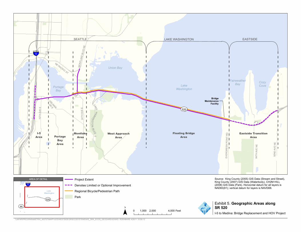
The 2009 Ecosystems Discipline Report (WSDOT 2009a) provides a detailed discussion of wetland effects from the No Build Alternative and Options A, K, and L (see pages 2-19 to 2-47 of the 2009 Ecosystems Discipline Report). The discussion below supplements the 2009 Ecosystems Discipline Report and discloses the effects of the Preferred Alternative, comparing it with the SDEIS options using new text and new or updated exhibits where appropriate. Similar to the SDEIS, the project is described in sections: I-5 area, Portage Bay area, Montlake area, west approach area, floating bridge area, and Eastside transition area (Exhibit 5).
What were the methods used to evaluate the potential effects and howhave they changed since publication of the SDEIS?
The potential effects of the Preferred Alternative were evaluated using the same methods as those used to evaluate the No Build Alternative and the SDEIS options (see pages 2-19 to 2-20 of the 2009 Ecosystems Discipline Report). The same methods were used so that the Preferred Alternative could be compared to the SDEIS options.
For both the SDEIS and the Final EIS, Geographic Information System (GIS) analysts calculated the physical effects of the proposed project by overlaying the construction and operation areas onto the surveyed wetland boundaries and designated buffers to determine the extent and location of clearing and filling resulting from the project. The analysts also calculated the area of wetland and buffer that would be shaded by elevated roadway (bridges and approach structures).
For the NRTWG and in later permit applications, a more refined analysis was performed than was done for the Final EIS. The NRTWG analysis considered the specific requirements of individual regulatory agencies and input from the Muckleshoot Indian Tribe.
The differences in effects between the Final EIS and the NRTWG are solely due to differences in analysis methods and not as a result of design changes made for the Preferred Alternative. In other words, if Options A, K, and L had been analyzed using the same methods as the Preferred Alternative in the NRTWG, the reported effects would have shown the same patterns of change. In the mitigation section, it was necessary to report the analysis of construction and operation effects using the methods from the NRTWG for two reasons: 1) mitigation commitments have been more fully defined in response to agency requests for greater detail, and 2) the Conceptual Wetland Mitigation Report (Attachment 9 to the Final EIS) is based on the NRTWG effects analysis for permitting purposes. The inclusion of both the Final EIS and NRTWG effects analysis in the report allows readers to compare the Preferred Alternative with the SDEIS options as well as understand the basis on which mitigation was calculated. More information regarding the differences in analysis is provided later in this section.
FEIS_ECOS_DRA_SUDS_26APR11 15
5
10TH
AVE E
DELMAR
DR E
24TH
AVE E
NE PACIFIC ST MO
NTLA
KEBL
VDNE
EVER
GREE
N PO
INT R
D
84TH
AVE N
E
92ND
AVE N
E
LAKE WASHINGTONBLVD E
5
LakeWashington
520
99
AREA OF DETAIL
SEATTLE LAKE WASHINGTON EASTSIDE
PortBay
age
Union Bay
FairweatBay
her CozyLake Cove
Washingt
I-5Area PortageBayMontlakeArea
on
Bridge Maintenance
Facility
520
West ApproachArea Floating Bridge Area
Eastside TransitiArea
on
Area
Project Extent Denotes Limited or Optional Improvement Regional Bicycle/Pedestrian Path Park
Source: King County (2005) GIS Data (Stream and Street),King County (2007) GIS Data (Waterbody), CH2M HILL (2008) GIS Data (Park). Horizontal datum for all layers isNAD83(91); vertical datum for layers is NAVD88.
0 1,000 2,000 4,000 Feet
Exhibit 5. Geographic Areas along SR 520 I-5 to Medina: Bridge Replacement and HOV Project
\\JAFAR\PROJ\PARAMETRIX_400707\MAPFILES\WESTSIDE\DR\ECOSYSTEMS\WS_DRA_ECOS_GEOGAREAS.MXD RGRABARE 4/26/11 10:56:12
SR 520, I-5 to Medina: Bridge Replacement and HOV Project | Final EIS and Final Section 4(f) and 6(f) Evaluations
The ordinary high water mark (OHWM) of Lake Washington was estimated using the following: U.S. Army Corps of Engineers (USACE) Lake Washington normal high maximum surface elevation of 18.72 feet, existing surveyed data, aerial photo interpretation, and the 2006 King County data when the other two sources were not available in a specific location.
How would construction of the project affect wetlands?
Preferred Alternative
To safely construct the Preferred Alternative, WSDOT would build construction work bridges in Portage Bay and Union Bay to maintain traffic in the project corridor during construction. Some work would be conducted from barges; however, barges generally would be used in deeper water and would not affect wetlands. Construction work bridges would generally be 30 feet wide, 5 to 10 feet above the high water elevation, and located on both the north and south sides of the bridge. The work bridges would remain in place for a combined duration of approximately 7 years. For additional discussion about construction sequencing, see the Construction Techniques and Activities Discipline Report Addendum and Errata (WSDOT 2011b).
Construction work bridges and construction activities would result in clearing, shading, and filling of wetlands during the construction period. Because the construction work bridges would be in place for more than two growing seasons, clearing, filling, and shading from construction activities would be considered long-term temporary, but not permanent, effects. Shading may affect the species composition and growth rates of vegetation, depending on the height of the structure, but would not likely eliminate vegetation. These effects would cease after the structures are removed. Many of the emergent and aquatic bed wetland areas would recolonize once they are no longer shaded. In those locations where clearing of vegetation occurs prior to construction of work bridges and then is shaded during the construction period, the effects are counted as shading to be consistent with the effects analysis presented in the SDEIS and the 2009 Ecosystems Discipline Report (WSDOT 2009a). Areas that would be cleared but not later shaded would be counted as a clearing effect. This approach prevents double counting of effects. Refer to pages 2-20 to 2-22 in the 2009 Ecosystems Discipline Report for further detail regarding these effects.
Refer to page 2-21 of the 2009 Ecosystems Discipline Report (WSDOT 2009a) and the Wetland Vegetation Response to Shade Special Study Technical Memorandum (WSDOT 2009b) for information regarding shading. In addition, since the publication of the SDEIS, WSDOT has worked with the agencies and the Muckleshoot Indian Tribe through the NRTWG to evaluate the effects of shade on wetlands. The intensity of permanent shade based on bridge height has been incorporated into the following operation effects analysis and associated mitigation. Refer to the Wetland Mitigation section of this addendum for details.
Construction activities would result in approximately 0.2 acre of cleared wetlands and 3.0 acres of cleared buffer. Of the 0.2 acre of cleared wetlands, 0.1 acre would be Category II, less than 0.1 acre Category III, and 0.1 acre would be Category IV wetlands. The affected wetlands would be Wetlands PBS-1A, LWN-1, LWN-2, LWS-4, LWS-4A, and LWS-5. Approximately 0.1 acre of this
FEIS_ECOS_DRA_SUDS_26APR11 17
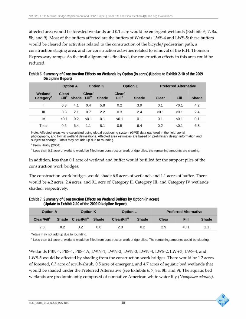
SR 520, I-5 to Medina: Bridge Replacement and HOV Project | Final EIS and Final Section 4(f) and 6(f) Evaluations
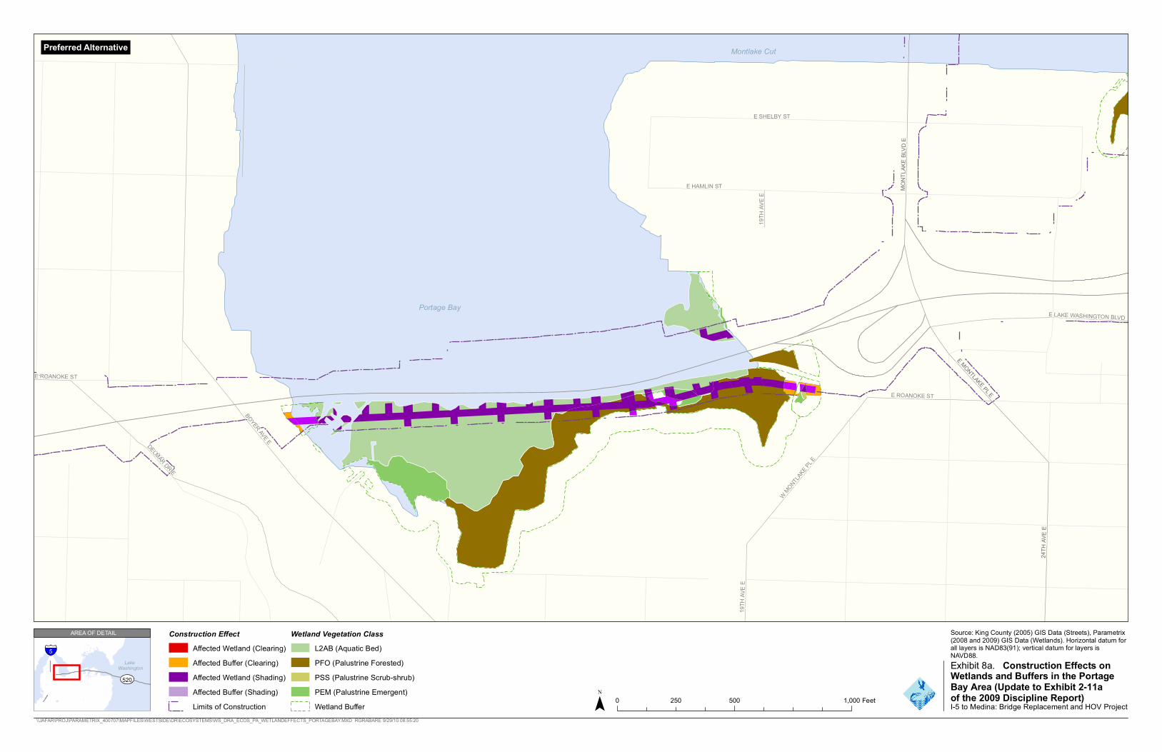
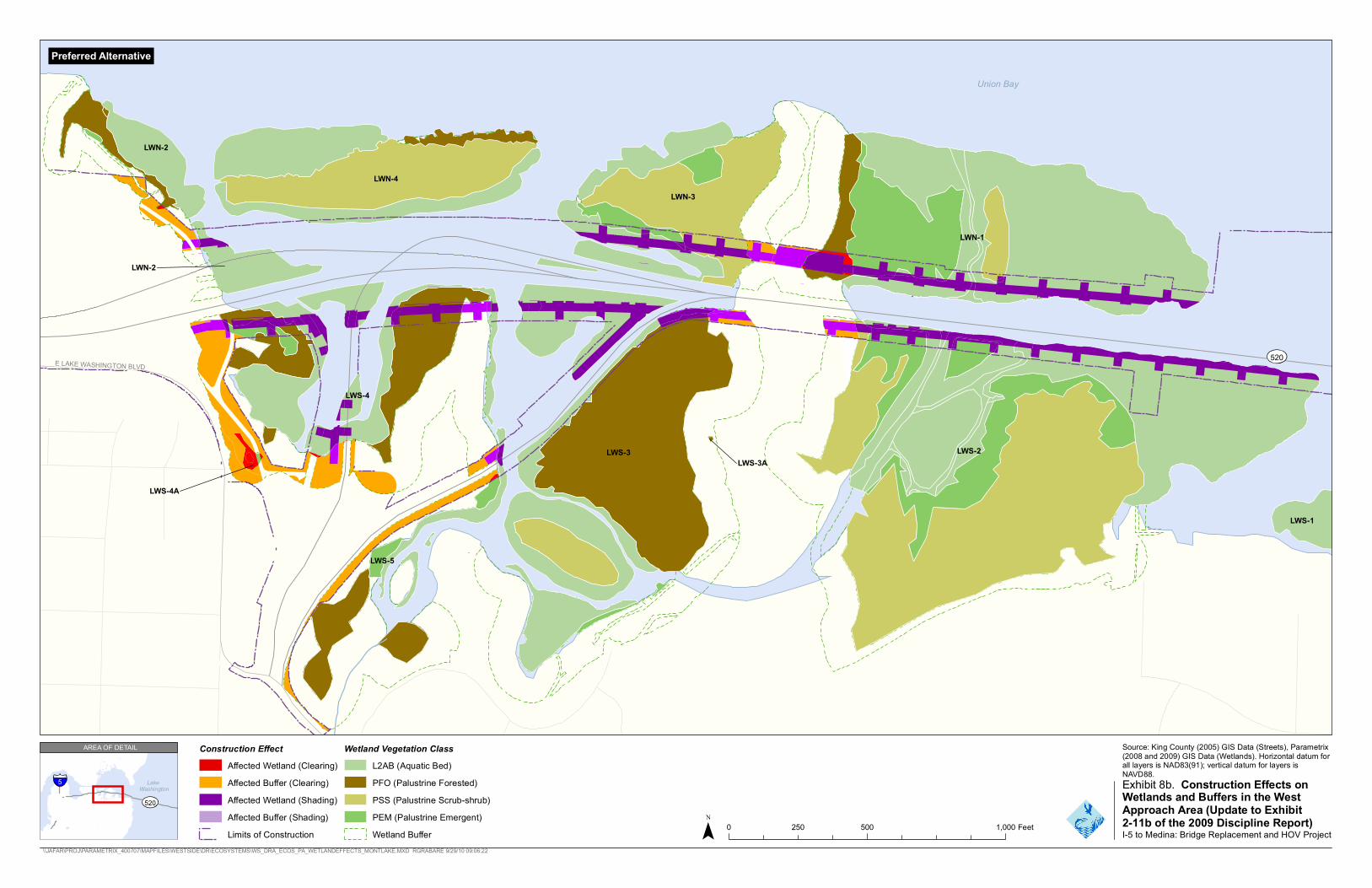
affected area would be forested wetlands and 0.1 acre would be emergent wetlands (Exhibits 6, 7, 8a, 8b, and 9). Most of the buffers affected are the buffers of Wetlands LWS-4 and LWS-5; these buffers would be cleared for activities related to the construction of the bicycle/pedestrian path, a construction staging area, and for construction activities related to removal of the R.H. Thomson Expressway ramps. As the trail alignment is finalized, the construction effects in this area could be reduced.
Exhibit 6. Summary of Construction Effects on Wetlands by Option (in acres) (Update to Exhibit 2-10 of the 2009 Discipline Report)
Option A Option K Option L Preferred Alternative
Wetland Categorya
Clear/ Fillb Shade
Clear/ Fillb Shade
Clear/ Fillb Shade Clear Fill Shade
II 0.3 4.1 0.4 5.8 0.2 3.9 0.1 <0.1 4.2
III 0.3 2.1 0.7 2.2 0.3 2.4 <0.1 <0.1 2.4
IV <0.1 0.2 <0.1 0.1 <0.1 0.1 0.1 <0.1 0.1
Total 0.6 6.4 1.1 8.1 0.5 6.4 0.2 <0.1 6.8
Note: Affected areas were calculated using global positioning system (GPS) data gathered in the field, aerial photography, and formal wetland delineations. Affected area estimates are based on preliminary design information and subject to change. Totals may not add up due to rounding. a From Hruby (2004). b Less than 0.1 acre of wetland would be filled from construction work bridge piles; the remaining amounts are clearing.
In addition, less than 0.1 acre of wetland and buffer would be filled for the support piles of the construction work bridges.
The construction work bridges would shade 6.8 acres of wetlands and 1.1 acres of buffer. There would be 4.2 acres, 2.4 acres, and 0.1 acre of Category II, Category III, and Category IV wetlands shaded, respectively.
Exhibit 7. Summary of Construction Effects on Wetland Buffers by Option (in acres) (Update to Exhibit 2-10 of the 2009 Discipline Report)
Option A Option K Option L Preferred Alternative
Clear/Filla Shade Clear/Filla Shade Clear/Filla Shade Clear Fill Shade
2.8 0.2 3.2 0.6 2.8 0.2 2.9 <0.1 1.1
Totals may not add up due to rounding. a Less than 0.1 acre of wetland would be filled from construction work bridge piles. The remaining amounts would be clearing.
Wetlands PBN-1, PBS-1, PBS-1A, LWN-1, LWN-2, LWN-3, LWN-4, LWS-2, LWS-3, LWS-4, and LWS-5 would be affected by shading from the construction work bridges. There would be 1.2 acres of forested, 0.3 acre of scrub-shrub, 0.5 acre of emergent, and 4.7 acres of aquatic bed wetlands that would be shaded under the Preferred Alternative (see Exhibits 6, 7, 8a, 8b, and 9). The aquatic bed wetlands are predominantly composed of nonnative American white water lily (Nymphaea odorata).
FEIS_ECOS_DRA_SUDS_26APR11 18
S E AT T L E
M E D I N A
19T H
AVE E
BOYER AVE E
E LAKE WASHINGTON BLVD
E ROANOKE ST
W MONTLAKE PL E
1 9TH
A VE E
E ROANOKE ST
DELMAR DR E
MONT
LAKE
BLV D
E
24TH
AVE E
E MONTLAKE PL E
Montlake Cut
E SHELBY ST
E HAMLIN ST
Portage Bay
Preferred Alternative
Source: King County (2005) GIS Data (Streets), Parametrix(2008 and 2009) GIS Data (Wetlands). Horizontal datum for all layers is NAD83(91); vertical datum for layers isNAVD88.
I-5 to Medina: Bridge Replacement and HOV Project \\JAFAR\PROJ\PARAMETRIX_400707\MAPFILES\WESTSIDE\DR\ECOSYSTEMS\WS_DRA_ECOS_PA_WETLANDEFFECTS_PORTAGEBAY.MXD RGRABARE 9/29/10 08:55:20
LakeWashington
520
AREA OF DETAIL Construction Effect Wetland Vegetation Class Affected Wetland (Clearing) L2AB (Aquatic Bed)Affected Buffer (Clearing) PFO (Palustrine Forested) Exhibit 8a. Construction Effects onAffected Wetland (Shading) PSS (Palustrine Scrub-shrub) Wetlands and Buffers in the Portage
PEM (Palustrine Emergent) Bay Area (Update to Exhibit 2-11aAffected Buffer (Shading) 0 250 500 1,000 Feet of the 2009 Discipline Report)
Limits of Construction Wetland Buffer
5

S E AT T L E
M E D I N A
E LAKE WASHINGTON BLVD
Union Bay
LWN-2
LWN-4 LWN-3
LWN-1
LWN-2
520
LWS-4
LWS-3 LWS-3A
LWS-2
LWS-4A
LWS-1
LWS-5
Preferred Alternative
Source: King County (2005) GIS Data (Streets), Parametrix(2008 and 2009) GIS Data (Wetlands). Horizontal datum for all layers is NAD83(91); vertical datum for layers isNAVD88.
I-5 to Medina: Bridge Replacement and HOV Project \\JAFAR\PROJ\PARAMETRIX_400707\MAPFILES\WESTSIDE\DR\ECOSYSTEMS\WS_DRA_ECOS_PA_WETLANDEFFECTS_MONTLAKE.MXD RGRABARE 9/29/10 09:06:22
5 LakeWashington
520
AREA OF DETAIL Construction Effect Wetland Vegetation Class Affected Wetland (Clearing) L2AB (Aquatic Bed)Affected Buffer (Clearing) PFO (Palustrine Forested) Exhibit 8b. Construction Effects on Affected Wetland (Shading) PSS (Palustrine Scrub-shrub) Wetlands and Buffers in the West
Approach Area (Update to ExhibitAffected Buffer (Shading) PEM (Palustrine Emergent) 0 250 500 1,000 Feet 2-11b of the 2009 Discipline Report)
Limits of Construction Wetland Buffer

SR 520, I-5 to Medina: Bridge Replacement and HOV Project | Final EIS and Final Section 4(f) and 6(f) Evaluations
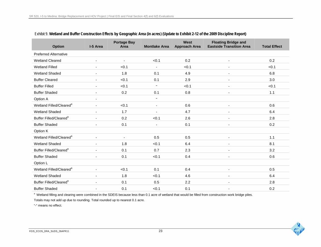
Exhibit 9. Wetland and Buffer Construction Effects by Geographic Area (in acres) (Update to Exhibit 2-12 of the 2009 Discipline Report)
Option I-5 Area Portage Bay
Area Montlake Area West
Approach Area Floating Bridge and
Eastside Transition Area Total Effect
Preferred Alternative
Wetland Cleared - - <0.1 0.2 - 0.2
Wetland Filled - <0.1 - <0.1 - <0.1
Wetland Shaded - 1.8 0.1 4.9 - 6.8
Buffer Cleared - <0.1 0.1 2.9 - 3.0
Buffer Filled - <0.1 - <0.1 - <0.1
Buffer Shaded - 0.2 0.1 0.8 - 1.1
Option A - -
Wetland Filled/Cleareda - <0.1 - 0.6 - 0.6
Wetland Shaded - 1.7 - 4.7 - 6.4
Buffer Filled/Cleareda - 0.2 <0.1 2.6 - 2.8
Buffer Shaded - 0.1 - 0.1 - 0.2
Option K
Wetland Filled/Cleareda - - 0.5 0.5 - 1.1
Wetland Shaded - 1.8 <0.1 6.4 - 8.1
Buffer Filled/Cleareda - 0.1 0.7 2.3 - 3.2
Buffer Shaded - 0.1 <0.1 0.4 - 0.6
Option L
Wetland Filled/Cleareda - <0.1 0.1 0.4 - 0.5
Wetland Shaded - 1.8 <0.1 4.6 - 6.4
Buffer Filled/Cleareda - 0.1 0.5 2.2 - 2.8
Buffer Shaded - 0.1 <0.1 0.1 - 0.2 a Wetland filling and clearing were combined in the SDEIS because less than 0.1 acre of wetland that would be filled from construction work bridge piles.
Totals may not add up due to rounding. Total rounded up to nearest 0.1 acre.
“-“ means no effect.
FEIS_ECOS_DRA_SUDS_26APR11 23
SR 520, I-5 to Medina: Bridge Replacement and HOV Project | Final EIS and Final Section 4(f) and 6(f) Evaluations
Pontoon Construction and Transport
Ten supplemental stability pontoons and 33 longitudinal and cross-pontoons would be constructed as part of the SR 520 Pontoon Construction Project. Forty-four additional supplemental stability pontoons could be constructed at CTC in the Port of Tacoma and/or at the pontoon construction facility in Grays Harbor. There are no wetlands at the Port of Tacoma facilities; therefore, no wetlands would be affected during pontoon construction. The effects to wetlands at the Grays Harbor facility occurred during site development and are discussed in the SR 520 Pontoon Construction Project Final EIS (WSDOT 2010a). While it is possible that launching pontoons at the Grays Harbor facility may cause wave action, propeller wash, and increased suspended sediment to affect estuarine emergent wetlands along the shoreline near the casting basin launch channel, pontoon launches would occur infrequently for short duration and effects would likely be negligible. No effects on wetlands are associated with pontoon transport, because there are no wetlands along the transport route.
For additional information about project construction schedules and pontoon construction, launch, and transport, please see the Construction Techniques and Activities Discipline Report Addendum and Errata (WSDOT 2011b).
How do the construction effects on wetlands compare to the SDEIS options?
The total construction effects on wetlands from the Preferred Alternative are similar to Option A. However, there is less clearing and more shade in the Preferred Alternative than in Option A. The Preferred Alternative would shade 0.4 acre more wetlands than Options A and L, but less than Option K (see Exhibit 9 and Exhibit 15). The increase in shading is due to the shift of the alignment south in Union Bay (west of Foster Island) to accommodate potential future light rail. The shift south pushed the alignment over wetlands, whereas in the SDEIS more of the bridges were over open water. However, if any of the SDEIS options were identified as the Preferred Alternative, design refinements to better accommodate light rail would likely result in a similar increased effect.
Clearing and fill effects on wetland buffers from the Preferred Alternative were similar to the SDEIS options. There would be 0.2 acre more buffer cleared than Options A and L and 0.2 acre less than Option K. Shading effects would be 0.5 acre more than Option K, and 0.9 acre more than Options A and L. Similar to effects on wetlands, this increase is due primarily to the shift of the alignment south in Union Bay.
How would operation of the project affect wetlands?
Preferred Alternative
The Preferred Alternative would have permanent effects on wetlands by permanently filling and shading some wetlands.
FEIS_ECOS_DRA_SUDS_26APR11 24

SR 520, I-5 to Medina: Bridge Replacement and HOV Project | Final EIS and Final Section 4(f) and 6(f) Evaluations
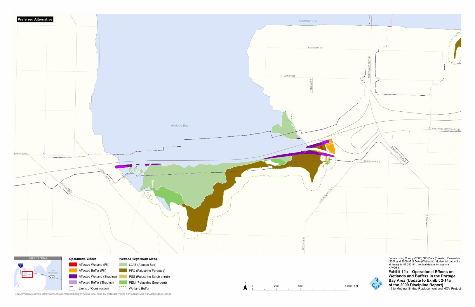
The Preferred Alternative would directly fill approximately 0.1 acre of wetland, primarily in the west approach area. This effect would include less than 0.1 acre each of forested, scrub-shrub, emergent, and aquatic bed wetlands. The affected wetlands would be PBS-1, LWN-1, LWN-2, LWN-3, LWS-2, LWS-3, LWS-4, and LWS-4A (Exhibits 10, 11, 12a, 12b, and 13).
The Preferred Alternative would affect Category II, III, and IV wetlands equally. In addition, the Preferred Alternative would fill 0.7 acre of buffer.
Fill in wetland is mainly from bridge support structures, such as columns, and from a small section of the bicycle/pedestrian path, which is located on the west shoreline of Union Bay. Most of the filling of buffers is from a stormwater treatment facility just east of Portage Bay and the bicycle/pedestrian path.
The Preferred Alternative would shade approximately 4.8 acres of wetlands. Aquatic bed wetlands would be most affected (3.9 acres), principally within the west approach area. Of the remaining acres, approximately 0.7 acre of forested wetlands, 0.2 acre of scrub-shrub wetlands, and less than 0.1 acre of emergent wetlands would be affected by shade. The shaded wetlands would be PBN-1, PBS-1, LWN-1, LWN-2, LWN-3, LWS-2, LWS-3, and LWS-4. Approximately 2.4, 2.4, and less than 0.1 acre of Category II, III, and IV wetlands, respectively, would be shaded under the Preferred Alternative. Approximately 1.1 acre of buffer would be permanently shaded (see Exhibits 10, 11, 12a, 12b, and 13).
Exhibit 10. Summary of Operational Effects on Wetlands by Option (in acres) (Update to Exhibit 2-13 of the 2009 Discipline Report)
Option A Option K Option L Preferred Alternative
Wetland Categorya Fill Shade Fill Shade Fill Shade Fill Shade
II < 0.1 0.7 0.5 1.5 < 0.1 1.9 < 0.1 2.4
III 0.1 2.1 1.2 1.4 0.2 2.4 < 0.1 2.4
IV < 0.1 0.3 0.1 < 0.1 0.1 < 0.1 < 0.1 < 0.1
Total 0.1 3.2 1.8 2.8 0.3 4.3 0.1 4.8
Note: Affected areas were calculated using GPS data gathered in the field, aerial photography, and formal wetland delineations. Affected area estimates are based on preliminary design information and subject to change. Totals may not add up due to rounding.
a From Hruby (2004).
FEIS_ECOS_DRA_SUDS_26APR11 25
SR 520, I-5 to Medina: Bridge Replacement and HOV Project | Final EIS and Final Section 4(f) and 6(f) Evaluations
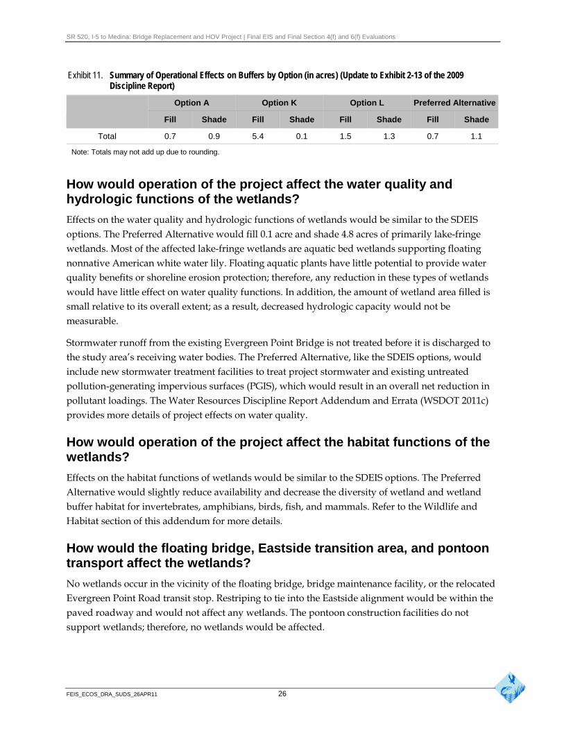
Exhibit 11. Summary of Operational Effects on Buffers by Option (in acres) (Update to Exhibit 2-13 of the 2009 Discipline Report)
Option A Option K Option L Preferred Alternative
Fill Shade Fill Shade Fill Shade Fill Shade
Total 0.7 0.9 5.4 0.1 1.5 1.3 0.7 1.1
Note: Totals may not add up due to rounding.
How would operation of the project affect the water quality and hydrologic functions of the wetlands?
Effects on the water quality and hydrologic functions of wetlands would be similar to the SDEIS options. The Preferred Alternative would fill 0.1 acre and shade 4.8 acres of primarily lake-fringe wetlands. Most of the affected lake-fringe wetlands are aquatic bed wetlands supporting floating nonnative American white water lily. Floating aquatic plants have little potential to provide water quality benefits or shoreline erosion protection; therefore, any reduction in these types of wetlands would have little effect on water quality functions. In addition, the amount of wetland area filled is small relative to its overall extent; as a result, decreased hydrologic capacity would not be measurable.
Stormwater runoff from the existing Evergreen Point Bridge is not treated before it is discharged to the study area’s receiving water bodies. The Preferred Alternative, like the SDEIS options, would include new stormwater treatment facilities to treat project stormwater and existing untreated pollution-generating impervious surfaces (PGIS), which would result in an overall net reduction in pollutant loadings. The Water Resources Discipline Report Addendum and Errata (WSDOT 2011c) provides more details of project effects on water quality.
How would operation of the project affect the habitat functions of the wetlands?
Effects on the habitat functions of wetlands would be similar to the SDEIS options. The Preferred Alternative would slightly reduce availability and decrease the diversity of wetland and wetland buffer habitat for invertebrates, amphibians, birds, fish, and mammals. Refer to the Wildlife and Habitat section of this addendum for more details.
How would the floating bridge, Eastside transition area, and pontoon transport affect the wetlands?
No wetlands occur in the vicinity of the floating bridge, bridge maintenance facility, or the relocated Evergreen Point Road transit stop. Restriping to tie into the Eastside alignment would be within the paved roadway and would not affect any wetlands. The pontoon construction facilities do not support wetlands; therefore, no wetlands would be affected.
FEIS_ECOS_DRA_SUDS_26APR11 26
S E AT T L E
M E D I N A
19T H
AVE E
BOYER AVE E
E LAKE WASHINGTON BLVD
E ROANOKE ST
W MONTLAKE PL E
1 9TH
A VE E
E ROANOKE ST
DELMAR DR E
MONT
LAKE
BLV D
E
24TH
AVE E
E MONTLAKE PL E
Montlake Cut
E SHELBY ST
E HAMLIN ST
Portage Bay
Preferred Alternative
Source: King County (2005) GIS Data (Streets), Parametrix(2008 and 2009) GIS Data (Wetlands). Horizontal datum for all layers is NAD83(91); vertical datum for layers isNAVD88.
I-5 to Medina: Bridge Replacement and HOV Project \\JAFAR\PROJ\PARAMETRIX_400707\MAPFILES\WESTSIDE\DR\ECOSYSTEMS\WS_DRA_ECOS_PA_WETLANDEFFECTS_PORTAGEBAY.MXD RGRABARE 9/29/10 08:55:20
LakeWashington
520
AREA OF DETAIL Operational Effect Wetland Vegetation Class Affected Wetland (Fill) L2AB (Aquatic Bed)Affected Buffer (Fill) PFO (Palustrine Forested) Exhibit 12a. Operational Effects onAffected Wetland (Shading) PSS (Palustrine Scrub-shrub) Wetlands and Buffers in the Portage
PEM (Palustrine Emergent) Bay Area (Update to Exhibit 2-14aAffected Buffer (Shading) 0 250 500 1,000 Feet of the 2009 Discipline Report)
Limits of Construction Wetland Buffer
5


S E AT T L E
M E D I N A
E LAKE WASHINGTON BLVD
Union Bay
LWN-2
LWN-4 LWN-3
LWN-1
LWN-2
520
LWS-4
LWS-3 LWS-3A
LWS-2
LWS-4A
LWS-1
LWS-5
Preferred Alternative
Source: King County (2005) GIS Data (Streets), Parametrix(2008 and 2009) GIS Data (Wetlands). Horizontal datum for all layers is NAD83(91); vertical datum for layers isNAVD88.
I-5 to Medina: Bridge Replacement and HOV Project \\JAFAR\PROJ\PARAMETRIX_400707\MAPFILES\WESTSIDE\DR\ECOSYSTEMS\WS_DRA_ECOS_PA_WETLANDEFFECTS_MONTLAKE.MXD RGRABARE 9/29/10 09:06:22
5 LakeWashington
520
AREA OF DETAIL Operational Effect Wetland Vegetation Class Affected Wetland (Fill) L2AB (Aquatic Bed)Affected Buffer (Fill) PFO (Palustrine Forested) Exhibit 12b. Operational Effects on Affected Wetland (Shading) PSS (Palustrine Scrub-shrub) Wetlands and Buffers in the West
Approach Area (Update to ExhibitAffected Buffer (Shading) PEM (Palustrine Emergent) 0 250 500 1,000 Feet 2-14b of the 2009 Discipline Report)
Limits of Construction Wetland Buffer

SR 520, I-5 to Medina: Bridge Replacement and HOV Project | Final EIS and Final Section 4(f) and 6(f) Evaluations
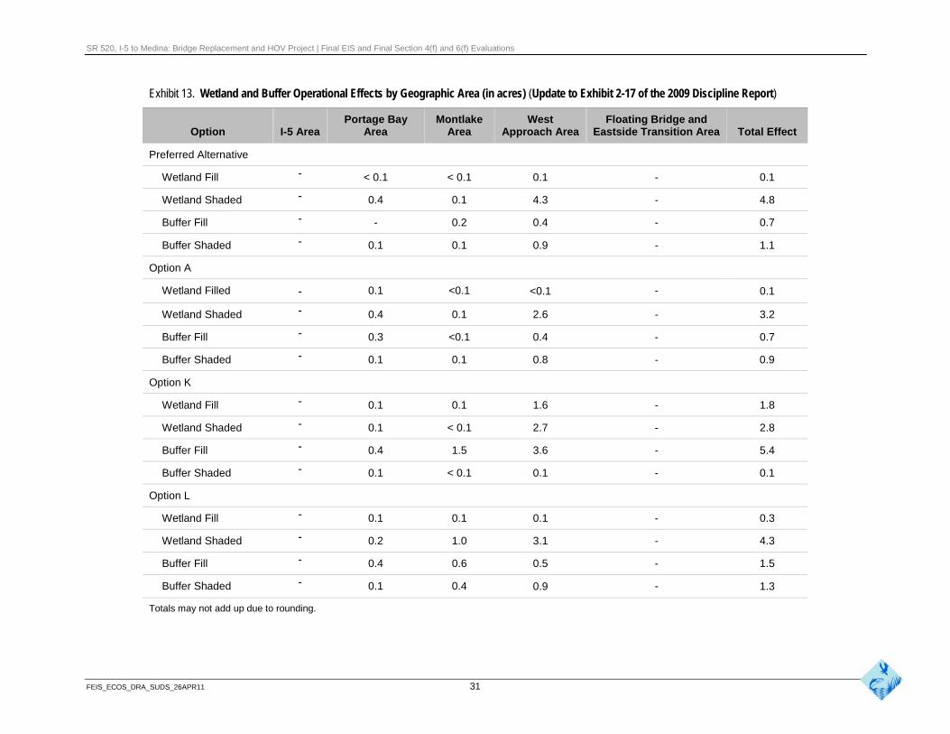
Exhibit 13. Wetland and Buffer Operational Effects by Geographic Area (in acres) (Update to Exhibit 2-17 of the 2009 Discipline Report)
Option I-5 Area Portage Bay
Area Montlake
Area West
Approach Area Floating Bridge and
Eastside Transition Area Total Effect
Preferred Alternative
Wetland Fill - < 0.1 < 0.1 0.1 - 0.1
Wetland Shaded - 0.4 0.1 4.3 - 4.8
Buffer Fill - - 0.2 0.4 - 0.7
Buffer Shaded - 0.1 0.1 0.9 - 1.1
Option A
Wetland Filled - 0.1 <0.1 <0.1 - 0.1
Wetland Shaded - 0.4 0.1 2.6 - 3.2
Buffer Fill - 0.3 <0.1 0.4 - 0.7
Buffer Shaded - 0.1 0.1 0.8 - 0.9
Option K
Wetland Fill - 0.1 0.1 1.6 - 1.8
Wetland Shaded - 0.1 < 0.1 2.7 - 2.8
Buffer Fill - 0.4 1.5 3.6 - 5.4
Buffer Shaded - 0.1 < 0.1 0.1 - 0.1
Option L
Wetland Fill - 0.1 0.1 0.1 - 0.3
Wetland Shaded - 0.2 1.0 3.1 - 4.3
Buffer Fill - 0.4 0.6 0.5 - 1.5
Buffer Shaded - 0.1 0.4 0.9 - 1.3
Totals may not add up due to rounding.
FEIS_ECOS_DRA_SUDS_26APR11 31
SR 520, I-5 to Medina: Bridge Replacement and HOV Project | Final EIS and Final Section 4(f) and 6(f) Evaluations
How do the operational effects on wetlands compare to the SDEIS options?
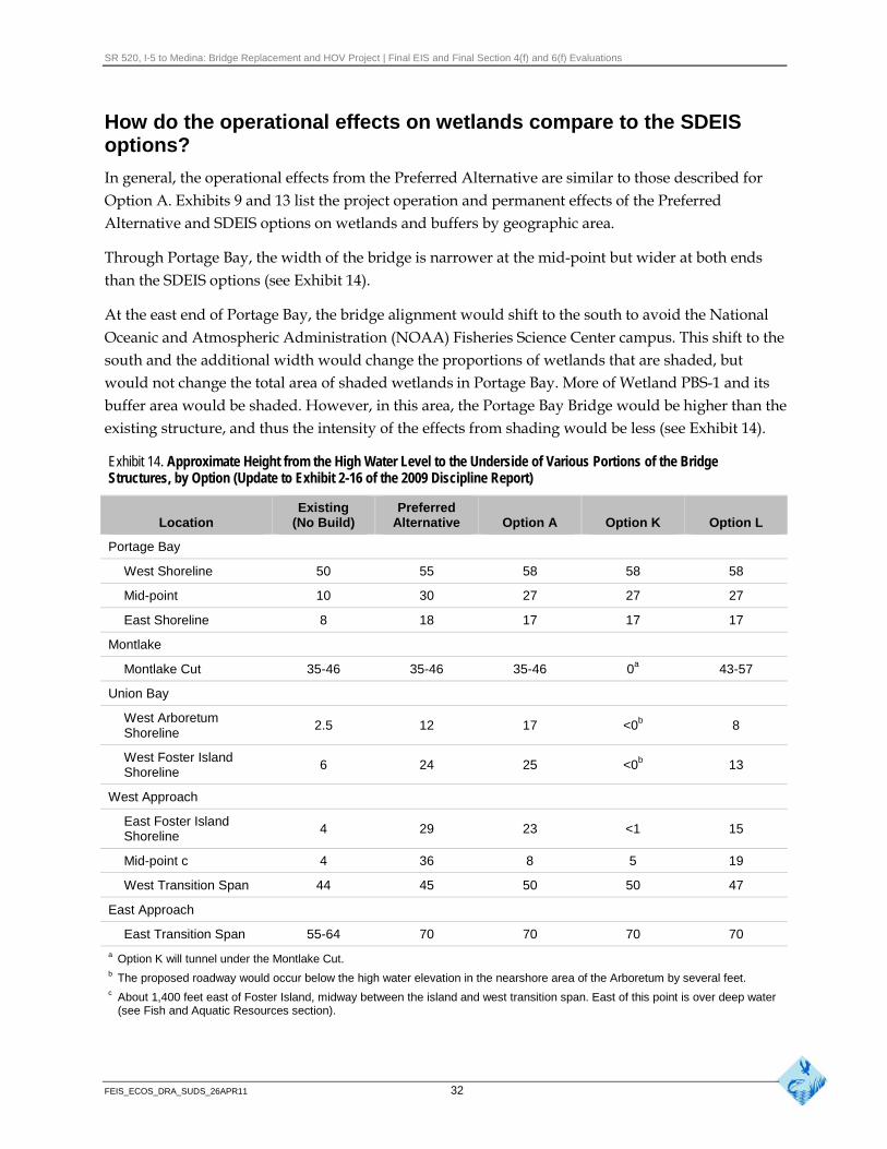
In general, the operational effects from the Preferred Alternative are similar to those described for Option A. Exhibits 9 and 13 list the project operation and permanent effects of the Preferred Alternative and SDEIS options on wetlands and buffers by geographic area.
Through Portage Bay, the width of the bridge is narrower at the mid-point but wider at both ends than the SDEIS options (see Exhibit 14).
At the east end of Portage Bay, the bridge alignment would shift to the south to avoid the National Oceanic and Atmospheric Administration (NOAA) Fisheries Science Center campus. This shift to the south and the additional width would change the proportions of wetlands that are shaded, but would not change the total area of shaded wetlands in Portage Bay. More of Wetland PBS-1 and its buffer area would be shaded. However, in this area, the Portage Bay Bridge would be higher than the existing structure, and thus the intensity of the effects from shading would be less (see Exhibit 14).
Exhibit 14. Approximate Height from the High Water Level to the Underside of Various Portions of the Bridge Structures, by Option (Update to Exhibit 2-16 of the 2009 Discipline Report)
Location Existing
(No Build) Preferred
Alternative Option A Option K Option L
Portage Bay
West Shoreline 50 55 58 58 58
Mid-point 10 30 27 27 27
East Shoreline 8 18 17 17 17
Montlake
Montlake Cut 35-46 35-46 35-46 0a 43-57
Union Bay
West Arboretum Shoreline
2.5 12 17 <0b 8
West Foster Island Shoreline
6 24 25 <0b 13
West Approach
East Foster Island Shoreline
4 29 23 <1 15
Mid-point c 4 36 8 5 19
West Transition Span 44 45 50 50 47
East Approach
East Transition Span 55-64 70 70 70 70
a Option K will tunnel under the Montlake Cut. b The proposed roadway would occur below the high water elevation in the nearshore area of the Arboretum by several feet. c About 1,400 feet east of Foster Island, midway between the island and west transition span. East of this point is over deep water
(see Fish and Aquatic Resources section).
FEIS_ECOS_DRA_SUDS_26APR11 32
SR 520, I-5 to Medina: Bridge Replacement and HOV Project | Final EIS and Final Section 4(f) and 6(f) Evaluations
In the Montlake area, the Preferred Alternative is in a similar location as Option A; for this reason, effects on wetlands and their buffers are similar to Option A.
In the west approach area, the bridge generally would be higher, but similar in design to Option A. The profile would be at a constant 0.7 percent grade, increasing from 12 feet above the water surface at the Montlake shoreline up to 48 feet at the west transition span of the floating bridge. The bottom of the bridge would be about 12 to 24 feet above the water through the Arboretum. The bridge would remain elevated over Foster Island, and be 24 feet high on the west shoreline and 28 feet high on the east shoreline (see Exhibit 14).
The intensity of the shade would vary based on the height of the bridge. An initial discussion of shade effects is presented on page 2-21 in the 2009 Discipline Report. Additional information from the Final Wetland Vegetation Response to Shade Special Study Technical Memorandum (WSDOT 2009b) was presented at the NRTWG meetings. WSDOT also conducted field trips with the resource agencies to the Evergreen Point Bridge in Union Bay and the I-90 Bridge in Mercer Slough to observe existing conditions. This information was used to assess the effects of shading on wetlands.
The intensity of shading of wetlands is expected to decrease as the structure increases in height. Those areas that are shaded by bridges over 24 feet would likely experience minimal changes in total vegetation cover except near the middle of the bridges (WSDOT 2009b). On the south side of the bridges, full sun and partial shade would extend northward under the bridges. Under the higher bridges, reflective and diffuse light would likely be sufficient to support plant growth. However, a change in vegetation composition could occur in some locations because of the reduced light. These considerations were not quantified in the effects analysis but are qualitatively described for the Final EIS; the entire area under the bridges were counted as shaded for the quantitative comparison of the Preferred Alternative to the SDEIS options.
The bridge structure through Union Bay (west of Foster Island) would be wider than today (Exhibit 12b). The gap between the eastbound and westbound structures would be wider for the Preferred Alternative than previously described to potentially accommodate light rail in the future. The accommodation of light rail pushed the bridge structure farther south, which resulted in more shading of wetlands than all the SDEIS options. Specifically, more forested and aquatic bed wetlands (Wetlands LWS-3 and LWS-4) in Union Bay would be shaded. However, if any of the SDEIS options were identified as the Preferred Alternative, design refinements to better accommodate light rail would likely result in a similar increased effect.
As with the SDEIS options, the existing Lake Washington Boulevard ramps and the R.H. Thomson Expressway ramps would be removed.
FEIS_ECOS_DRA_SUDS_26APR11 33
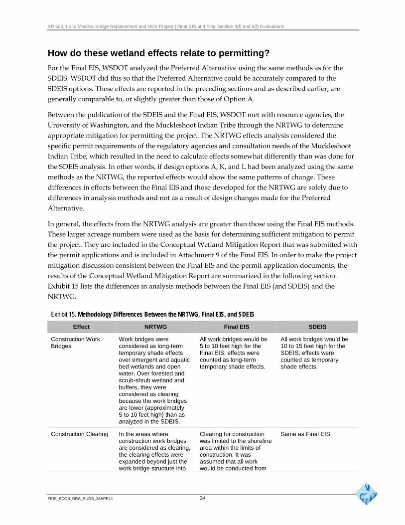
SR 520, I-5 to Medina: Bridge Replacement and HOV Project | Final EIS and Final Section 4(f) and 6(f) Evaluations
How do these wetland effects relate to permitting?
For the Final EIS, WSDOT analyzed the Preferred Alternative using the same methods as for the SDEIS. WSDOT did this so that the Preferred Alternative could be accurately compared to the SDEIS options. These effects are reported in the preceding sections and as described earlier, are generally comparable to, or slightly greater than those of Option A.
Between the publication of the SDEIS and the Final EIS, WSDOT met with resource agencies, the University of Washington, and the Muckleshoot Indian Tribe through the NRTWG to determine appropriate mitigation for permitting the project. The NRTWG effects analysis considered the specific permit requirements of the regulatory agencies and consultation needs of the Muckleshoot Indian Tribe, which resulted in the need to calculate effects somewhat differently than was done for the SDEIS analysis. In other words, if design options A, K, and L had been analyzed using the same methods as the NRTWG, the reported effects would show the same patterns of change. These differences in effects between the Final EIS and those developed for the NRTWG are solely due to differences in analysis methods and not as a result of design changes made for the Preferred Alternative.
In general, the effects from the NRTWG analysis are greater than those using the Final EIS methods. These larger acreage numbers were used as the basis for determining sufficient mitigation to permit the project. They are included in the Conceptual Wetland Mitigation Report that was submitted with the permit applications and is included in Attachment 9 of the Final EIS. In order to make the project mitigation discussion consistent between the Final EIS and the permit application documents, the results of the Conceptual Wetland Mitigation Report are summarized in the following section. Exhibit 15 lists the differences in analysis methods between the Final EIS (and SDEIS) and the NRTWG.
Exhibit 15. Methodology Differences Between the NRTWG, Final EIS, and SDEIS
Effect NRTWG Final EIS SDEIS
Construction Work Work bridges were All work bridges would be All work bridges would be Bridges considered as long-term 5 to 10 feet high for the 10 to 15 feet high for the
temporary shade effects Final EIS; effects were SDEIS; effects were over emergent and aquatic counted as long-term counted as temporary bed wetlands and open temporary shade effects. shade effects. water. Over forested and scrub-shrub wetland and buffers, they were considered as clearing because the work bridges are lower (approximately 5 to 10 feet high) than as analyzed in the SDEIS.
Construction Clearing In the areas where Clearing for construction Same as Final EIS construction work bridges was limited to the shoreline are considered as clearing, area within the limits of the clearing effects were construction. It was expanded beyond just the assumed that all work work bridge structure into would be conducted from
FEIS_ECOS_DRA_SUDS_26APR11 34
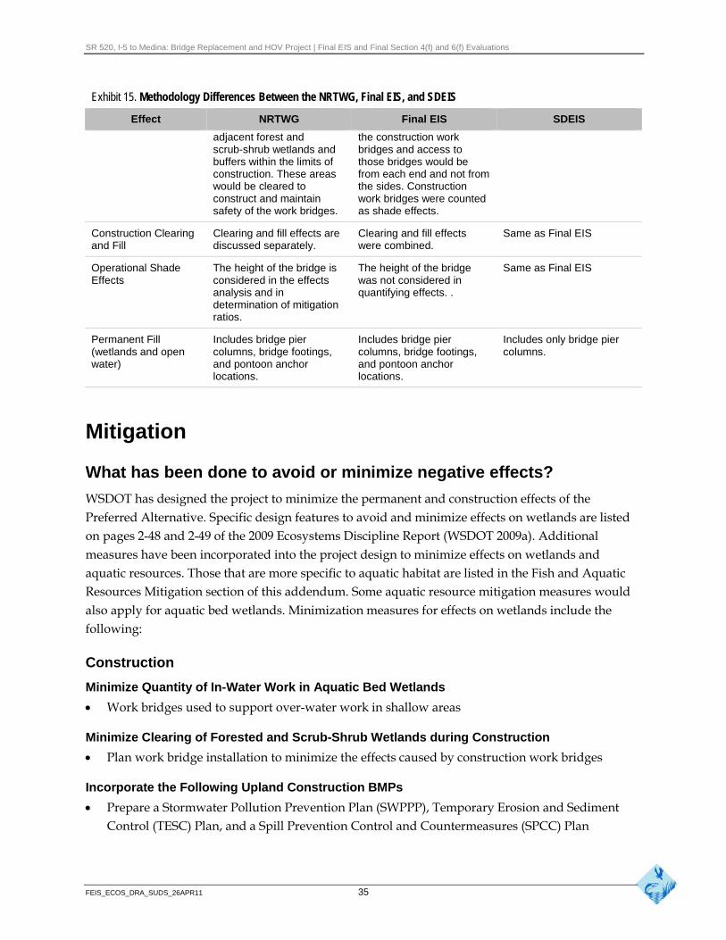
SR 520, I-5 to Medina: Bridge Replacement and HOV Project | Final EIS and Final Section 4(f) and 6(f) Evaluations
Exhibit 15. Methodology Differences Between the NRTWG, Final EIS, and SDEIS
Effect NRTWG Final EIS SDEIS
adjacent forest and scrub-shrub wetlands and buffers within the limits of construction. These areas would be cleared to construct and maintain safety of the work bridges.
the construction work bridges and access to those bridges would be from each end and not from the sides. Construction work bridges were counted as shade effects.
Construction Clearing and Fill
Clearing and fill effects are discussed separately.
Clearing and fill effects were combined.
Same as Final EIS
Operational Shade Effects
The height of the bridge is considered in the effects
The height of the bridge was not considered in
Same as Final EIS
analysis and in determination of mitigation ratios.
quantifying effects. .
Permanent Fill (wetlands and open water)
Includes bridge pier columns, bridge footings, and pontoon anchor locations.
Includes bridge pier columns, bridge footings, and pontoon anchor locations.
Includes only bridge pier columns.
Mitigation
What has been done to avoid or minimize negative effects?
WSDOT has designed the project to minimize the permanent and construction effects of the Preferred Alternative. Specific design features to avoid and minimize effects on wetlands are listed on pages 2-48 and 2-49 of the 2009 Ecosystems Discipline Report (WSDOT 2009a). Additional measures have been incorporated into the project design to minimize effects on wetlands and aquatic resources. Those that are more specific to aquatic habitat are listed in the Fish and Aquatic Resources Mitigation section of this addendum. Some aquatic resource mitigation measures would also apply for aquatic bed wetlands. Minimization measures for effects on wetlands include the following:
Construction
Minimize Quantity of In-Water Work in Aquatic Bed Wetlands
Work bridges used to support over-water work in shallow areas
Minimize Clearing of Forested and Scrub-Shrub Wetlands during Construction
Plan work bridge installation to minimize the effects caused by construction work bridges
Incorporate the Following Upland Construction BMPs
Prepare a Stormwater Pollution Prevention Plan (SWPPP), Temporary Erosion and Sediment Control (TESC) Plan, and a Spill Prevention Control and Countermeasures (SPCC) Plan
FEIS_ECOS_DRA_SUDS_26APR11 35
SR 520, I-5 to Medina: Bridge Replacement and HOV Project | Final EIS and Final Section 4(f) and 6(f) Evaluations
Ensure a Certified Erosion and Sediment Control Lead (CESCL) is consulted and be onsite during construction activities
Clearly define construction limits with stakes and high visibility fence before beginning ground-disturbing activities
Minimize vegetation and soil disturbance to the extent possible
Avoid or reduce adverse effects on critical areas during project construction, including shoreline buffers; these measures would include clearing, grading, and stormwater management
Protect designated sensitive areas, including the shoreline, with a silt fence and remove the entire fence when construction is completed
Control all stormwater discharges from construction sites and ensure discharge water quality standards are met
Implement appropriate cover and catchment measures to cover/contain work areas, debris, and staging areas
Use construction water treatment systems to treat water before discharging to receiving water bodies
Operation
Minimize Filling of Wetlands by Reducing In-Water Structure
Increase span length and column spacing from existing condition
Use mudline footings for structure foundations (reduces in-water structure)
Minimize Shading Effects on Wetlands
Bridge height increased compared to existing condition and to SDEIS designs
Bridge width minimized by minimizing number of lanes and shoulder widths in Portage Bay and portions of the west approach
Minimize Water Quality Effects on Aquatic Bed Wetlands by Collecting and Treating Stormwater Prior to Discharge
Use enhanced stormwater treatment where possible
Minimize Effects on Shoreline Wetlands by Locating Outfalls at or near Existing Outfalls
Discharge future outfalls above the OHWM
Dissipate energy above the OHWM
Conduct revegetation between outfalls and water
FEIS_ECOS_DRA_SUDS_26APR11 36
SR 520, I-5 to Medina: Bridge Replacement and HOV Project | Final EIS and Final Section 4(f) and 6(f) Evaluations
What mitigation is proposed to compensate for project effects?
Approach to Mitigation
WSDOT engaged regulatory agencies in collaborative technical working groups to assist in the development of appropriate mitigation for project effects. Project mitigation was discussed in detail during the NRTWG meetings held from June to October 2010, which comprised federal, state, and local regulatory agencies, the University of Washington, and the Muckleshoot Indian Tribe. The goal of the meetings was to identify the sites that would be the best candidates for mitigating the types and amount of project effects. Mitigation sites underwent detailed analysis prior to inclusion in the wetland mitigation plans. The wetland mitigation plans incorporate field investigations, scientific research, and the collective knowledge from the NRTWG and the project mitigation team.
An Initial Wetland Mitigation Report was prepared in the fall of 2009 (WSDOT 2009f), and was included in Attachment 9 of the SDEIS (WSDOT 2010b). Comments were received and incorporated into the Conceptual Wetland Mitigation Report for permit submittals in April 2011. This conceptual plan is attached to the Final EIS (Attachment 9) and is part of the permit applications. Project mitigation is summarized in Sections 5 and 6 of the Final EIS.
The effects acreage quantities reported below are those developed for the NRTWG and reported in the Conceptual Wetland Mitigation Report. All mitigation estimates are based on these quantities. They differ from those reported above in some instances.
As described above, these quantities were calculated using methods different from those used for the effects analysis conducted to compare National Environmental Policy Act (NEPA) alternatives and options as reported in Exhibit 15. The two reasons for the primary difference between the mitigation quantities reported in the SDEIS Ecosystems Discipline Report (WSDOT 2009a, pages 2-50 to 2-52) and those in this addendum are as follows:
There was an increased refinement of the construction methods, resulting in more precise quantification of effects and required mitigation for the Preferred Alternative; and
Mitigation ratios for both construction and operation shade effects were not previously available but were established in the NRTWG for the Preferred Alternative.
In the SDEIS Ecosystems Discipline Report (WSDOT 2009a) no construction or shade mitigation was reported.
Construction Mitigation
Unavoidable construction effects of the project would result from the temporary structures necessary to construct the permanent replacement bridge. These construction effects would be largely long term, greater than one growing season, due to the length of the construction process. The construction effects include approximately 0.2 acre of long-term temporary fill in wetlands. Although the final configuration of the construction work bridge piles would be determined by the
FEIS_ECOS_DRA_SUDS_26APR11 37
SR 520, I-5 to Medina: Bridge Replacement and HOV Project | Final EIS and Final Section 4(f) and 6(f) Evaluations
contractor, all of this long-term temporary fill would be assumed to occur in Category II wetlands (the highest category wetland in the vicinity).
Construction of the project would result in 2.8 acres of clearing (Table 1, Conceptual Wetland Mitigation Report, Attachment 9 of the Final EIS). Of these 2.8 acres, 1.1 acres would be in Category II wetlands, 1.7 acres would be in Category III wetlands, and less than 0.1 acre would be category IV wetlands. The structures necessary to construct the replacement bridge would also result in 5.3 acres of shading. These 5.3 acres include 3.5 acres in Category II wetlands, 1.7 acres in Category III wetlands, and 0.1 acre in Category IV wetlands.
WSDOT would restore forested and scrub-shrub wetland areas that were cleared for construction according to mitigation ratios agreed to at the NRTWG meetings. These ratios were derived by using standard ratios in the joint guidance (Ecology et al. 2006) plus modifiers agreed to by the agencies with jurisdiction over wetlands. Long-term temporary shading effects resulting from the approximately 7-year construction period, depending on location, would be mitigated at offsite replacement sites identified in the following section.
Operation Mitigation
The SR 520, I-5 to Medina project would result in permanent, long-term effects on wetlands and buffers. The project would permanently fill approximately0.3 acre of wetlands in the study area. This approximately 0.3 acre includes 0.1 acre of fill in Category II wetland, 0.2 acre of fill in Category III wetlands, and less than 0.1 acre of fill in Category IV (Table 1, Conceptual Wetland Mitigation Report, Attachment 9 of the Final EIS). Shading from the project would result in 4.9 acres of permanent effects on wetlands in the study area. These 4.9 acres of shading would be split approximately equally between Category II wetlands and Category III wetlands. Approximately 0.60 acre of existing ramps would be removed and allowed to restore naturally to partially offset operation shade effects, resulting in a net shade effect of 4.3 acres and a net total effect of 4.6 acres. Permanent effects on buffers include approximately 1.9 acre of permanent fill and 0.8 acre of permanent shading in wetland buffers. The fill effect would be primarily from buffer restoration activities.
The Conceptual Wetland Mitigation Report provides an in-depth examination of mitigation sequencing, site selection, site characteristics, mitigation goals and acreage, construction activities, performance monitoring, and long-term protection of the sites. The goal of the compensatory mitigation would be to achieve no net loss of wetland area or function.
Mitigation Site Summary
The SR 520, I-5 to Medina project will provide compensatory mitigation for all the project wetland effects in five locations. Four of the locations are onsite or in proximity to the project, and one is located several miles from the project but in the same watershed (Exhibit 16). These sites are briefly described below.
FEIS_ECOS_DRA_SUDS_26APR11 38
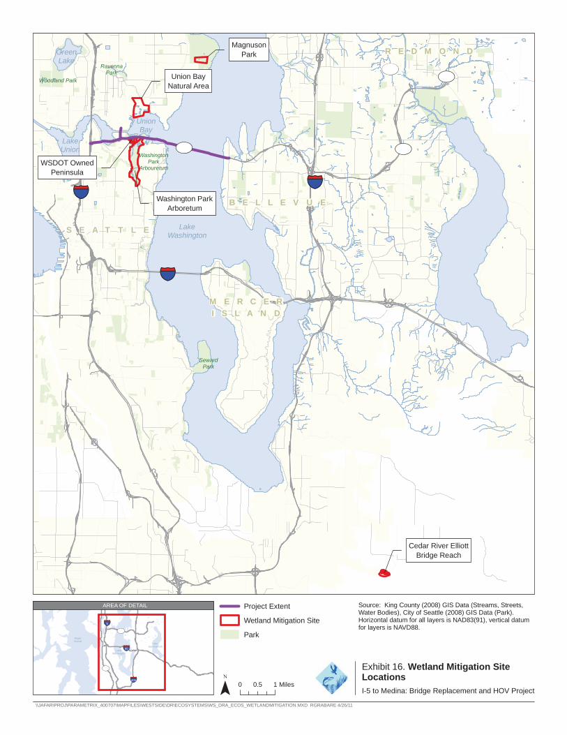
Magnuson R E D M O N DGreen Park
Lake Ravenna
908 Park VUnion Bay U202 Woodland Park UV
Natural Area
Union Bay
Lake Union 520 520 UV UVWashington
Park Arbouretum
WSDOT Owned Peninsula
5§̈¦405
Washington Park B E L L E V U E Arboretum
Lake
§̈¦
S E A T T L E Washington
90
M E R C E R
I S L A N D
Seward Park
§̈¦
Cedar River Elliott Bridge Reach
AREA OF DETAIL Project Extent Source: King County (2008) GIS Data (Streams, Streets, Water Bodies), City of Seattle (2008) GIS Data (Park).
Wetland Mitigation Site Horizontal datum for all layers is NAD83(91), vertical datum for layers is NAVD88.§̈¦5
Puget Sound
Lake
520 UV Park
§̈¦
§̈¦90
Washington
99 Exhibit 16. Wetland Mitigation Site UVLocations 405
Sammamish
Lake
¯ 0 1 Miles 0.5 I-5 to Medina: Bridge Replacement and HOV Project
\\JAFAR\PROJ\PARAMETRIX_400707\MAPFILES\WESTSIDE\DR\ECOSYSTEMS\WS_DRA_ECOS_WETLANDMITIGATION.MXD RGRABARE 4/26/11
SR 520, I-5 to Medina: Bridge Replacement and HOV Project | Final EIS and Final Section 4(f) and 6(f) Evaluations
How would vegetation removal and shading from project operation affect City of Seattle shoreline habitat?
The shoreline of Lake Washington is protected by the City of Seattle Shoreline Master program (CSC 23.60). A portion of the overall wildlife habitat in the study area encompasses the City’s shoreline habitat. Of this area, approximately 1.0 acre of City of Seattle-designated shoreline habitat would be permanently removed and 0.6 acre would be permanently shaded by the Preferred Alternative.
How would changes in water quality during project operation affect wildlife and habitat?
The Preferred Alternative would include stormwater treatment facilities to treat and remove pollutants from the roadway and associated structures. Similar to the SDEIS options, sediment loads to receiving water bodies, including wetlands, would be reduced from existing conditions with the Preferred Alternative.
The Water Resources Discipline Report Addendum and Errata (WSDOT 2011c) provides updated information regarding the anticipated effects on water quality within specific basins.
How would project operation cause disturbances to wildlife?
Highway noise disturbs wildlife and can affect species distribution and behavior. Noise levels in the general area are predicted to be lower under the Preferred Alternative than existing conditions and in some locations, may be slightly higher than described for the SDEIS options. Consequently, noise disturbance to wildlife would be the same as outlined in the 2009 Ecosystems Discipline Report (pages 4-48 and 4-59) and likely slightly lower than under existing conditions. In addition, refer to the Noise Discipline Report Addendum and Errata (WSDOT 2011d) for more details regarding noise effects from the Preferred Alternative.
How would project operation result in barriers or obstructions to wildlife movement?
Throughout most of the Seattle area, the roadway would be higher above the water than the existing bridges, and would be higher through Union Bay out to the west transition span than with the SDEIS options. Effects on wildlife would be similar to the SDEIS options. Elevating the roadway (especially through the Foster Island area) could positively or negatively affect waterfowl and shorebirds, depending on their flight patterns and behavior. Refer to pages 4-60 and 4-61 in the 2009 Ecosystems Discipline Report (WSDOT 2009a) for more information.
The portion of the highway that crosses Foster Island would be adjacent to forested passerine bird habitat similar to existing conditions. However, the bridges would be elevated approximately 24 to 28 feet high above the western and eastern shorelines and could influence foraging behavior in this area.
FEIS_ECOS_DRA_SUDS_26APR11 40
SR 520, I-5 to Medina: Bridge Replacement and HOV Project | Final EIS and Final Section 4(f) and 6(f) Evaluations
For terrestrial wildlife, passage between the north and south portions of Foster Island would improve under the Preferred Alternative, similar to Options A and L. Under existing conditions, SR 520’s at-grade roadway and adjacent fencing are barriers to wildlife movement.
The upland area is mostly a grass field with a few scattered large trees. Elevations extend from the waterline to approximately 12 feet above lake level.
The northern portion of the peninsula is approximately 4 acres from which wetlands could be created by excavating the site. The southern portion has been reported to include the old Miller Street Landfill (see the 2009 Hazardous Materials Discipline Report [WSDOT 2009c]). The actual acreage of wetland creation will be determined by the extent and contents of the landfill. Additional subsurface testing of this replacement site will be done before the site’s final design. Additional wetland enhancement would be accomplished by shrub and tree planting along the shoreline.
Union Bay Natural Area Mitigation Site
The Union Bay Natural Area is owned and managed by the University of Washington. It is directly north across Union Bay from the SR 520, I-5 to Medina project. WSDOT and the University have discussed partnering on restoration opportunities within this site. After discussions, three potential mitigation areas have been identified that are consistent with the long-term management plans of the Union Bay Natural Area. They include a linear area adjacent to the University Slough, the Union Bay shoreline, and the large center pond area. Nearly 6 acres of wetland would be created east of the University Slough by excavating uplands in these three areas. These uplands reside on top of the Montlake Landfill, which was capped with up to 3 feet of topsoil after closure (see the 2009 Hazardous Materials Discipline Report for more information).
At the University Slough site, fill would be removed from an existing parking lot to near the lake level. This area would be vegetated with wetland emergent and shrub species. Also along the University Slough but farther to the north, upland areas would be excavated to create seasonal wetlands. On the Union Bay shoreline, an old berm would be removed and the area would be planted with trees and shrubs. In addition, an area near the central pond would involve excavating the top layer of fill and then planting with emergent vegetation, shrubs, and trees.
Magnuson Park
Magnuson Park is owned by the City of Seattle and managed by Seattle Parks and Recreation. The site is approximately 2.5 miles north of SR 520 near the Lake Washington shoreline. The proposed mitigation concept has been developed in consultation with the City of Seattle and will be consistent with the Magnuson Park Master Plan.
The site would be graded to harvest additional water from nearby areas and offsite facilities establishing new seasonally and permanently inundated wetland areas and to extend the hydroperiods of existing wetlands. The onsite existing compacted soil would be replaced with topsoil conducive to native plant growth to increase wetland functions such as water storage and water quality improvements. Non-native species would be removed and replanting with native
FEIS_ECOS_DRA_SUDS_26APR11 41
SR 520, I-5 to Medina: Bridge Replacement and HOV Project | Final EIS and Final Section 4(f) and 6(f) Evaluations
species, retaining clumps of native trees. The wetlands would be located farther from Beach Drive and major trails to provide a wider and more densely planted buffer with more vertical structure to increase wildlife use in the wetland and buffer.
Lake Washington Boulevard Ramps
In addition, the three Lake Washington Boulevard ramps would be removed, which would offset some of the wetland shading by exposing previously shaded areas. These ramps are mainly over upland or open-water areas, as opposed to vegetated wetlands, but their removal would expose approximately 0.6 acre of open water. It is expected that the adjacent aquatic bed wetlands would regrow and expand into these areas. In addition, 18 support columns would be removed, which would expose approximately less than 0.1 acre of aquatic substrate.
Offsite Mitigation Opportunities
Cedar River Floodplain Mitigation Site
WSDOT would develop a floodplain restoration site along the Cedar River on land owned by King County. The restored floodplain would contain both wetland and aquatic habitat restoration opportunities. The site previously contained several residential properties, including houses, driveways, outbuildings, and other features. These structures and underlying old fill would be removed. Certain areas would be excavated and planted to create wetlands, riparian habitat, and back-channel habitat. Details on the aquatic habitat restoration opportunities at this site are provided in the Fish and Aquatic Resources section of this addendum.
What negative effects would remain after mitigation?
The mitigation proposed is intended to fully mitigate for project effects on wetlands.
Fish and Aquatic Resources
Affected Environment
What were the updates to the affected environment?
Updates were made to the affected environment for fish and aquatic resources since preparation of the SDEIS analysis. Pages 3-1 to 3-26 of the 2009 Ecosystems Discipline Report (WSDOT 2009a) describe the affected environment.
With the adoption of the Preferred Alternative, specific features of the Lake Washington area are no longer a part of the affected environment. The Preferred Alternative reduced the overall project footprint, which removed the University Slough basin from the water resources affected by project construction and operation. This revision resulted because the impervious surface north of the intersection of NE Pacific Street and Montlake Boulevard NE would no longer be changed.
FEIS_ECOS_DRA_SUDS_26APR11 42
SR 520, I-5 to Medina: Bridge Replacement and HOV Project | Final EIS and Final Section 4(f) and 6(f) Evaluations
Exhibit 17 was updated to reflect this change. Updated information regarding water quality is described in the Water Resources Discipline Report Addendum and Errata (WSDOT 2011c).
Additional geotechnical surveys documented offshore groundwater upwelling forces in the east approach area (see Geology and Soils Discipline Report Addendum and Errata [WSDOT 2011g]). This information resulted in changing the bridge support structures to include mudline footings that are supported by multiple drilled shafts, instead of individual drilled shaft/column structures. This change would result in substantially greater benthic substrate effects than previously disclosed in the SDEIS. The footings are located in an area that has substrate and groundwater upwelling conditions suitable to support spawning sockeye salmon. In addition, construction of the maintenance facility may increase groundwater draw down, resulting in effects on upwelling in the sockeye spawning habitat. The draw down is expected to be relatively minor, however, and not preclude or substantially degrade the quality of sockeye spawning habitat. Additional information about the upwelling is provided in the Geology and Soils Discipline Report Addendum and Errata (WSDOT 2011g).
At the request of resource agencies and the Muckleshoot Indian Limnology refers to the biological,
Tribe, a review of the limnological characteristics in the lake was chemical, and physical conditions that affect the productivity of a water conducted to assess whether the deeper draft of the floating bridge body.
pontoons could have some effects on circulation patterns in the immediate vicinity and in the overall limnological processes in the lake. More information regarding limnology is included in this section.
The Washington Department of Fish and Wildlife (WDFW) Priority Habitats and Species database was reviewed since the publication of the SDEIS to determine if there had been any changes to the habitat classification and fish distributions in the study area and vicinity (WDFW 2010). There were no updates to the Priority Habitats and Species database and no other updates to the affected environment for fish and aquatic resources since preparation of the SDEIS analysis.
Potential Effects
The 2009 Ecosystems Discipline Report (WSDOT 2009a) provides a detailed discussion of effects of the No Build Alternative and Options A, K, and L (see pages 3-26 to 3-72) on fish and aquatic resources. The discussion below supplements the 2009 Ecosystems Discipline Report and compares the effects of the Preferred Alternative with the SDEIS options using new text, and new or updated exhibits where appropriate.
What were the methods used to evaluate the potential effects and howhave they changed since publication of the SDEIS?
The potential effects of the Preferred Alternative were evaluated using similar methods for evaluating the potential effects of the No Build Alternative and Options A, K, and L (see pages 3-26 to 3-27 of the Ecosystems Discipline Report). Since the SDEIS was published, more information has
FEIS_ECOS_DRA_SUDS_26APR11 43
SR 520, I-5 to Medina: Bridge Replacement and HOV Project | Final EIS and Final Section 4(f) and 6(f) Evaluations
been developed on how the project (regardless of alterative or design option) could affect fish and aquatic resources in the study area. This information includes the results of the pile-driving test project, additional bridge lighting analyses, a review of potential lake circulation and limnological effects of the deeper floating bridge, and additional construction sequencing information.
For the construction sequencing, GIS analysts calculated the area of open-water habitat that would be shaded by the elevated roadway (bridges and approach structures), and work bridges as the project would be sequentially built for the Preferred Alternative. This approach is similar to the analysis used for the options addressed in the SDEIS.
As described in the Wetlands section, WSDOT engaged regulatory agencies, the University of Washington, and the Muckleshoot Indian Tribe in the collaborative NRTWG process to assist in identification and refinement of effect mechanisms on aquatic resources and the development of appropriate mitigation measures. Information from the NRTWG is incorporated into this addendum as appropriate.
How would construction of the project affect fish and aquatic resources?
Preferred Alternative
Overall project construction activities, locations, durations, and methods would be similar for all of the SDEIS options and the Preferred Alternative. The total construction period would be approximately 7 years. As with the SDEIS options, the Preferred Alternative would build new structures and/or maintain existing structures within the shoreline and open-water habitats that support various fish species throughout much of the Seattle study area and Lake Washington. The types of effects are similar to the SDEIS options described on pages 3-27 to 3-57 of the 2009 Ecosystems Discipline Report (WSDOT 2009a). The primary differences between the Preferred Alternative and the SDEIS options occur in the Seattle study area, which extends from the I-5 interchange to the floating portion of the Evergreen Point Bridge.
All in-water construction activities, like pile-driving, would occur during project specific work windows approved by the regulatory agencies. WSDOT has coordinated with the regulatory agencies and the Muckleshoot Indian Tribe to establish site and project specific in-water work windows to minimize the potential for project activities to affect juvenile or adult salmonids.
Seattle
The Preferred Alternative requires similar construction work bridges as described for the SDEIS options, extending along both sides of the bridge alignment. However, construction methods were refined after publication of the SDEIS, resulting in a change in assumptions for work bridge heights. For the SDEIS, work bridges were assumed to be approximately 10 to 15 feet above the water surface; for the Preferred Alternative work bridges are assumed to generally be 5 to 10 feet above the water surface. These construction work bridges would typically be in place for an estimated 2 to 5 years depending on location.
FEIS_ECOS_DRA_SUDS_26APR11 44
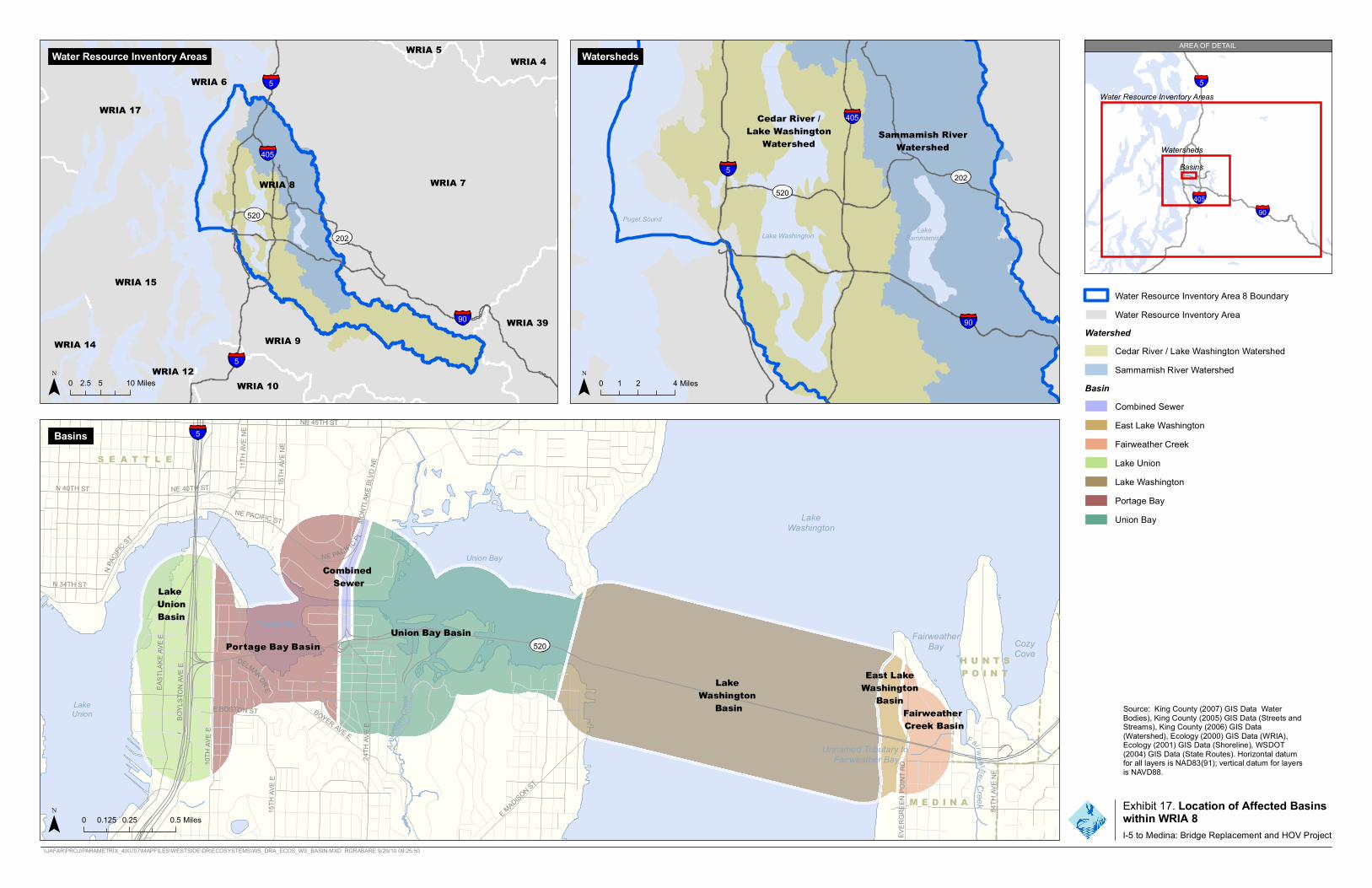
A R R O WP O I N T
NE 40TH ST
84TH
AVE N
E
DELMAR DR E
BOSTON ST BOYER AV E E
15TH
AVE E
BOY L
STON
AVE E
N 40TH ST
E MADISON ST
10TH
AVE E
EAST
L AKE
AVE E
24TH
A VE E
1 5T H
AVE N
E
NE 45TH ST
11T H
AVE N
E
NE PACIFIC PL
MO
NTLA
KE BL
VD NE
N 34TH ST
N PAC
IFIC
ST
NE PACIFIC ST
RDPO
INT
E VE R
GREE
N
Arbo
ret
um Cr
eek
Fairwea ther
90
AREA OF DETAILWater Resource Inventory Areas WRIA 5 WRIA 4 Watersheds
WRIA 6 5
WRIA 17
405
WRIA 8 WRIA 7
520
202
WRIA 15
WRIA 14 WRIA 12 5
WRIA 9
WRIA 10
90 WRIA 39
5 Water Resource Inventory Areas
Watersheds Basins
405
0 2.5 5 10 Miles
Basins 5
S E A T T L E
Combined
LakeWashington
Union Bay
Cedar River / 405Lake Washington Sammamish RiverWatershed Watershed
5 202
520
Puget Sound LakeLake Washington Sammamish
90
SewerLakeUnionBasin YPortage Bay
Portage Bay Basin Union Bay Basin Fairweat
Bay her Cozy
Cove520
LakeUnion E
East LakeLake WashingtonWashington BasinBasin
H U N T S
P O I N T
FairweatherCreek Basin
Unnamed Tributary toFai ther Bayrwea
0 0.125 0.25 0.5 Miles
Water Resource Inventory Area 8 BoundaryWater Resource Inventory Area
Watershed
0 1 2 4 Miles
Cedar River / Lake Washington Watershed Sammamish River Watershed
Basin Combined Sewer East Lake Washington Fairweather Creek Lake Union Lake Washington Portage BayUnion Bay
Source: King County (2007) GIS Data WaterBodies), King County (2005) GIS Data (Streets andStreams), King County (2006) GIS Data(Watershed), Ecology (2000) GIS Data (WRIA),Ecology (2001) GIS Data (Shoreline), WSDOT(2004) GIS Data (State Routes). Horizontal datumfor all layers is NAD83(91); vertical datum for layersis NAVD88.
M E D I N A
Creek Exhibit 17. Location of Affected Basins within WRIA 8 I-5 to Medina: Bridge Replacement and HOV Project
\\JAFAR\PROJ\PARAMETRIX_400707\MAPFILES\WESTSIDE\DR\ECOSYSTEMS\WS_DRA_ECOS_WS_BASIN.MXD RGRABARE 9/29/10 09:25:50

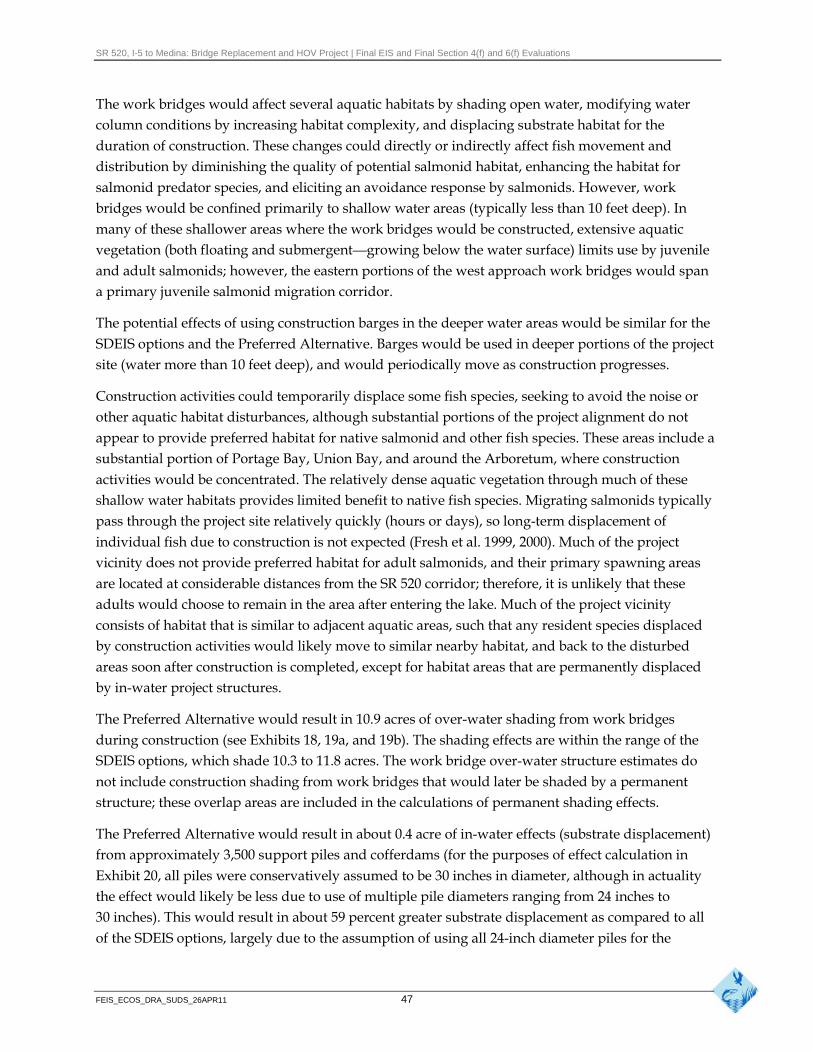
SR 520, I-5 to Medina: Bridge Replacement and HOV Project | Final EIS and Final Section 4(f) and 6(f) Evaluations
The work bridges would affect several aquatic habitats by shading open water, modifying water column conditions by increasing habitat complexity, and displacing substrate habitat for the duration of construction. These changes could directly or indirectly affect fish movement and distribution by diminishing the quality of potential salmonid habitat, enhancing the habitat for salmonid predator species, and eliciting an avoidance response by salmonids. However, work bridges would be confined primarily to shallow water areas (typically less than 10 feet deep). In many of these shallower areas where the work bridges would be constructed, extensive aquatic vegetation (both floating and submergent—growing below the water surface) limits use by juvenile and adult salmonids; however, the eastern portions of the west approach work bridges would span a primary juvenile salmonid migration corridor.
The potential effects of using construction barges in the deeper water areas would be similar for the SDEIS options and the Preferred Alternative. Barges would be used in deeper portions of the project site (water more than 10 feet deep), and would periodically move as construction progresses.
Construction activities could temporarily displace some fish species, seeking to avoid the noise or other aquatic habitat disturbances, although substantial portions of the project alignment do not appear to provide preferred habitat for native salmonid and other fish species. These areas include a substantial portion of Portage Bay, Union Bay, and around the Arboretum, where construction activities would be concentrated. The relatively dense aquatic vegetation through much of these shallow water habitats provides limited benefit to native fish species. Migrating salmonids typically pass through the project site relatively quickly (hours or days), so long-term displacement of individual fish due to construction is not expected (Fresh et al. 1999, 2000). Much of the project vicinity does not provide preferred habitat for adult salmonids, and their primary spawning areas are located at considerable distances from the SR 520 corridor; therefore, it is unlikely that these adults would choose to remain in the area after entering the lake. Much of the project vicinity consists of habitat that is similar to adjacent aquatic areas, such that any resident species displaced by construction activities would likely move to similar nearby habitat, and back to the disturbed areas soon after construction is completed, except for habitat areas that are permanently displaced by in-water project structures.
The Preferred Alternative would result in 10.9 acres of over-water shading from work bridges during construction (see Exhibits 18, 19a, and 19b). The shading effects are within the range of the SDEIS options, which shade 10.3 to 11.8 acres. The work bridge over-water structure estimates do not include construction shading from work bridges that would later be shaded by a permanent structure; these overlap areas are included in the calculations of permanent shading effects.
The Preferred Alternative would result in about 0.4 acre of in-water effects (substrate displacement) from approximately 3,500 support piles and cofferdams (for the purposes of effect calculation in Exhibit 20, all piles were conservatively assumed to be 30 inches in diameter, although in actuality the effect would likely be less due to use of multiple pile diameters ranging from 24 inches to 30 inches). This would result in about 59 percent greater substrate displacement as compared to all of the SDEIS options, largely due to the assumption of using all 24-inch diameter piles for the
FEIS_ECOS_DRA_SUDS_26APR11 47
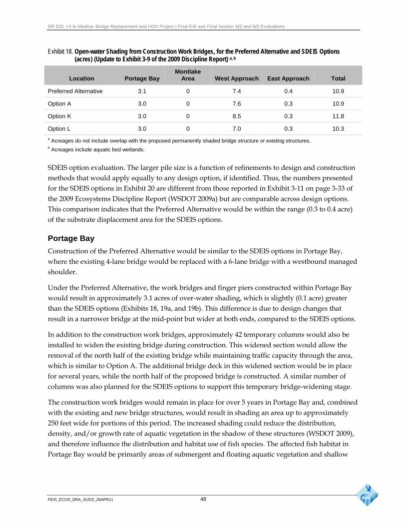
SR 520, I-5 to Medina: Bridge Replacement and HOV Project | Final EIS and Final Section 4(f) and 6(f) Evaluations
Exhibit 18. Open-water Shading from Construction Work Bridges, for the Preferred Alternative and SDEIS Options (acres) (Update to Exhibit 3-9 of the 2009 Discipline Report) a, b
Montlake Location Portage Bay Area West Approach East Approach Total
Preferred Alternative 3.1 0 7.4 0.4 10.9
Option A 3.0 0 7.6 0.3 10.9
Option K 3.0 0 8.5 0.3 11.8
Option L 3.0 0 7.0 0.3 10.3
a Acreages do not include overlap with the proposed permanently shaded bridge structure or existing structures. b Acreages include aquatic bed wetlands.
SDEIS option evaluation. The larger pile size is a function of refinements to design and construction methods that would apply equally to any design option, if identified. Thus, the numbers presented for the SDEIS options in Exhibit 20 are different from those reported in Exhibit 3-11 on page 3-33 of the 2009 Ecosystems Discipline Report (WSDOT 2009a) but are comparable across design options. This comparison indicates that the Preferred Alternative would be within the range (0.3 to 0.4 acre) of the substrate displacement area for the SDEIS options.
Portage Bay
Construction of the Preferred Alternative would be similar to the SDEIS options in Portage Bay, where the existing 4-lane bridge would be replaced with a 6-lane bridge with a westbound managed shoulder.
Under the Preferred Alternative, the work bridges and finger piers constructed within Portage Bay would result in approximately 3.1 acres of over-water shading, which is slightly (0.1 acre) greater than the SDEIS options (Exhibits 18, 19a, and 19b). This difference is due to design changes that result in a narrower bridge at the mid-point but wider at both ends, compared to the SDEIS options.
In addition to the construction work bridges, approximately 42 temporary columns would also be installed to widen the existing bridge during construction. This widened section would allow the removal of the north half of the existing bridge while maintaining traffic capacity through the area, which is similar to Option A. The additional bridge deck in this widened section would be in place for several years, while the north half of the proposed bridge is constructed. A similar number of columns was also planned for the SDEIS options to support this temporary bridge-widening stage.
The construction work bridges would remain in place for over 5 years in Portage Bay and, combined with the existing and new bridge structures, would result in shading an area up to approximately 250 feet wide for portions of this period. The increased shading could reduce the distribution, density, and/or growth rate of aquatic vegetation in the shadow of these structures (WSDOT 2009), and therefore influence the distribution and habitat use of fish species. The affected fish habitat in Portage Bay would be primarily areas of submergent and floating aquatic vegetation and shallow
FEIS_ECOS_DRA_SUDS_26APR11 48
SR 520, I-5 to Medina: Bridge Replacement and HOV Project | Final EIS and Final Section 4(f) and 6(f) Evaluations
open water. These areas are not considered good or preferred habitat for salmonids, but likely provide suitable habitat for juvenile salmonid predator species, such as smallmouth bass, yellow perch, and northern pikeminnow. Therefore, construction activities in these areas are not expected to substantially or directly affect salmonid species. Effects on aquatic habitat from construction would cease once the construction work bridges and the existing bridge are removed.
The Preferred Alternative would require about 850 hollow steel piles to support the work bridges in Portage Bay, or about 100 more than the SDEIS options. The work bridge piles would occupy about 6,250 square feet of substrate, or at least 2,550 more square feet than the SDEIS options. The affected habitat is not considered preferred or suitable habitat for salmonid species, and the dense vegetation likely limits the habitat use by other fish species.
The Preferred Alternative would also require an additional 400 hollow steel piles to support falsework for constructing the architectural treatment on the Portage Bay replacement bridge, or about 100 more piles than and SDEIS options. The work bridge and falsework support pile requirements represent a design refinement made since publication of the SDEIS, and result in more piles than disclosed in the SDEIS. The falsework piles would occupy a total of about 2,000 square feet of substrate, based on 30-inch-diameter piles. All work bridges, finger piers, and falsework structures would be removed after completion of the new Portage Bay Bridge and removal of the existing bridge.
In Portage Bay, and in other project waters, the pile-driving activities would use a vibratory hammer as often as practicable to minimize in-water noise levels. However, some impact pile-driving would be required for all work bridge piles in order to achieve adequate depth and load-bearing capacities. These piles would later be removed with a vibratory hammer. Exceptionally stubborn piles that cannot be removed would be cut off 2 feet below the mudline. Pile-driving production estimates vary, but based on the results of the test-pile program conducted in the study area (WSDOT 2010c), it is estimated that each pile-driving crew could install a maximum of 8 piles a day, with an average of 500 pile-driving strikes required for each pile in Portage Bay, Union Bay, and the west approach. However, due to the more consolidated sediments found in the east approach area, it is assumed that up to 1,000 pile-driving strikes might be required for each pile in that area. To optimize the use of the in-water work windows, several pile-driving crews would likely be working at the same time, including multiple locations within Portage Bay. Therefore, the maximum extent of pile-driving on any particular day could average between 8,000 and 16,000 pile strikes for the entire study area. Pile-driving sound waves radiate in all
directions, but diminish in intensity It is likely that pile-driving activities would have the greatest (attenuate) as the wave spreads over a
larger area. Waves are also attenuated potential to injure fish due to the increased sound pressures or blocked by encountering obstructions
caused by the impact hammer striking the pile. If severe enough, such as shallow water or land masses. Therefore, potential effects on fish these sound pressure waves can injure or kill fish. WSDOT, in diminish with distance and their location
coordination with FHWA and the Services, participated in the relative to obstructions.
Fisheries Hydroacoustic Working Group and has agreed to use noise thresholds for injury to fish (FHWG 2008).
FEIS_ECOS_DRA_SUDS_26APR11 49
SR 520, I-5 to Medina: Bridge Replacement and HOV Project | Final EIS and Final Section 4(f) and 6(f) Evaluations
Using noise attenuation BMPs, the range of potential injury for juvenile and subadult/adult salmonids is approximately 3 feet for a single pile strike (WSDOT 2010c). The distance of potential for injury from cumulative pile strikes for juvenile and adult salmonids remaining in close proximity for an entire day of pile-driving was about 7 feet. Behavioral effects, based on a conservative 150 dB threshold, would extend for approximately 72 feet in most areas, but could be up to 446 feet near the west transition span. Sound levels would differ at different sites due to different geotechnical conditions, vegetation density, and water depth. In addition to minimizing effects from pile-driving noise using sound-reducing BMPs, the work bridges would be constructed in relatively shallow water (generally less than 10 feet deep) where aquatic vegetation typically grows. The relatively dense aquatic vegetation beds found in most of the proposed pile-driving areas are expected to limit the use of this habitat by salmonids and other anadromous fish.
Since publication of the SDEIS, design refinements were made and construction assumptions modified in the Portage Bay Bridge area. For the Preferred Alternative and the SDEIS options, the Portage Bay Bridge would construct mudline footings for the three westerly in-water pier bents. The footings would be constructed inside of cofferdams measuring about 130 feet by 40 feet, each. These three cofferdams would occupy a total area of about 0.4 acre of substrate habitat. The SDEIS evaluated 14 smaller (about 37 feet by 37 feet) footings (two per bent), for the 7 western bridge bents, with each footing supporting 2 bridge columns. The new footing design and the three large cofferdams now described in this Final EIS would occupy a similar combined area as the smaller cofferdams described in the SDEIS, but the larger cofferdams would substantially decrease the extent and duration of in-water work to install and subsequently remove them.
Montlake Area
In the Montlake area, the Preferred Alternative would be similar to Option A, consisting of building a new bascule bridge across the Montlake Cut. These activities would primarily be limited to upland and over-water work. Any in-water work (such as the placement of structures) would occur from barges.
To reduce the potential effects of construction activities on vessel traffic, the bridge would be constructed one leaf at a time, so that half the bridge could remain open through some of the 4-month over-water construction period. Construction barges would likely only be located in the Montlake Cut during actual bridge assembly work.
West Approach Area
As in Portage Bay, the Preferred Alternative would be sequentially constructed in the west approach area, with the proposed bridge overlapping with the location of the existing bridge. In-water construction would occur from construction work bridges in shallow water areas (less than 20 feet deep), where construction staging from barges is not practicable. The construction activities and the potential effects would be similar to those described for Option A.
FEIS_ECOS_DRA_SUDS_26APR11 50
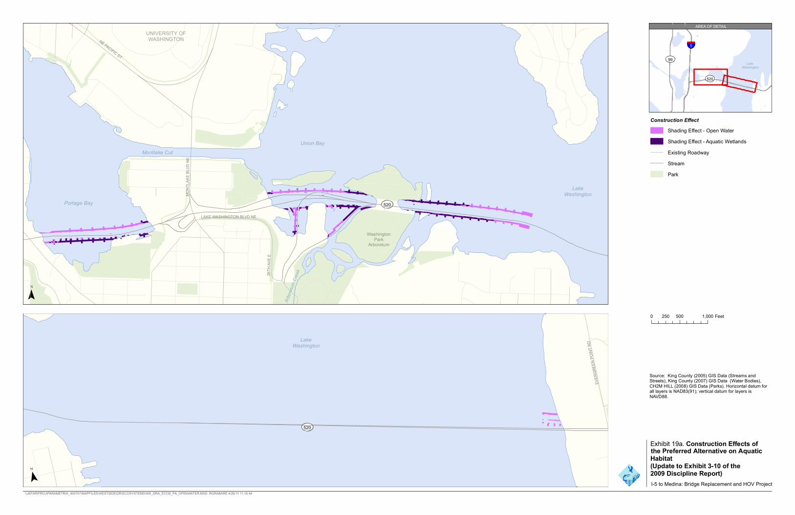
E LYNN ST
15TH
AVE
N
520
Washington Park
Arboretum
Lake Washington
Portage Bay
Union Bay
Montlake Cut
26TH
AV
E E
NE PACIFIC ST
MO
NTL
AK
EB
LVD
NE
LAKE WASHINGTON BLVD NE
UNIVERSITY OF WASHINGTON
Arbo
retu
mC
reek
520
Lake Washington
EVE
RG
RE
EN
POIN
TR
D
Lake Washington
520
5
99
AREA OF DETAIL
Construction Effect
Shading Effect - Open Water
Shading Effect - Aquatic Wetlands
Existing Roadway
Stream
Park
0 500 1,000250 Feet
Source: King County (2005) GIS Data (Streams and Streets), King County (2007) GIS Data (Water Bodies), CH2M HILL (2008) GIS Data (Parks). Horizontal datum for all layers is NAD83(91); vertical datum for layers is NAVD88.
Exhibit 19a. Construction Effects of the Preferred Alternative on Aquatic Habitat (Update to Exhibit 3-10 of the 2009 Discipline Report) I-5 to Medina: Bridge Replacement and HOV Project
\\JAFAR\PROJ\PARAMETRIX_400707\MAPFILES\WESTSIDE\DR\ECOSYSTEMS\WS_DRA_ECOS_PA_OPENWATER.MXD RGRABARE 4/26/11 11:16:44

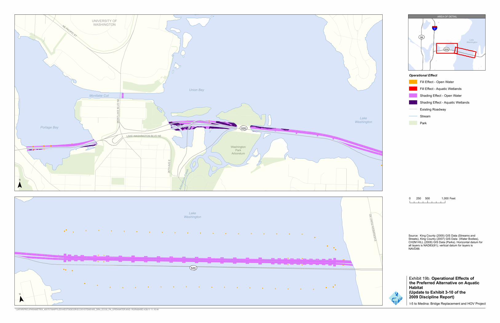
E LYNN ST
15TH
AVE
N
26TH
AV
E E
NE PACIFIC ST
Arbo
retu
mC
reek
EVE
RG
RE
EN
POIN
TR
D
MO
TA
KB
LLV
DN
NE
E
Portage Bay 520
LAKE WASHINGTON BLVD NE
Washington Park
Arboretum
AREA OF DETAIL
UNIVERSITY OF WASHINGTON
5
99 Lake
Washington
520
Union Bay
Montlake Cut
Lake Washington
Operational Effect
Fill Effect - Open Water
Fill Effect - Aquatic Wetlands
Shading Effect - Open Water
Shading Effect - Aquatic Wetlands
Existing Roadway
Stream
Park
0 250 500 1,000 Feet
Lake Washington
Source: King County (2005) GIS Data (Streams and Streets), King County (2007) GIS Data (Water Bodies), CH2M HILL (2008) GIS Data (Parks). Horizontal datum for all layers is NAD83(91); vertical datum for layers is NAVD88.
520
Exhibit 19b. Operational Effects ofthe Preferred Alternative on Aquatic Habitat (Update to Exhibit 3-10 of the 2009 Discipline Report) I-5 to Medina: Bridge Replacement and HOV Project
\\JAFAR\PROJ\PARAMETRIX_400707\MAPFILES\WESTSIDE\DR\ECOSYSTEMS\WS_DRA_ECOS_PA_OPENWATER.MXD RGRABARE 4/26/11 11:16:44

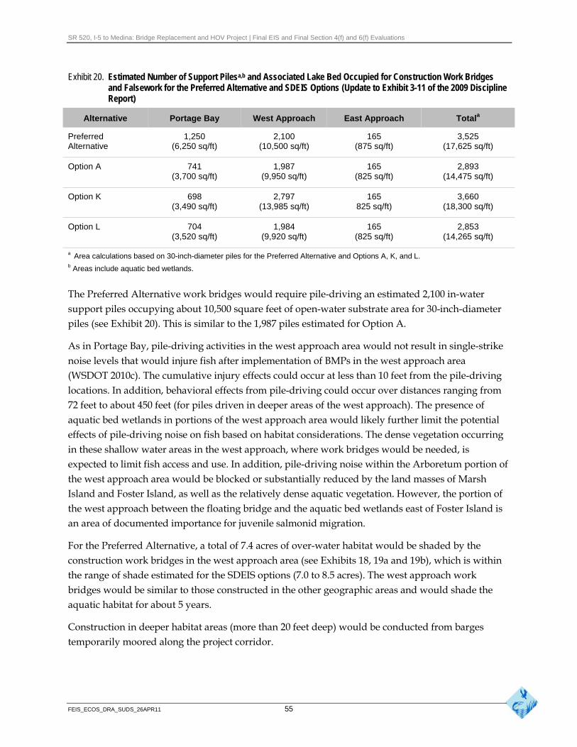
SR 520, I-5 to Medina: Bridge Replacement and HOV Project | Final EIS and Final Section 4(f) and 6(f) Evaluations
Exhibit 20. Estimated Number of Support Pilesa,b and Associated Lake Bed Occupied for Construction Work Bridges and Falsework for the Preferred Alternative and SDEIS Options (Update to Exhibit 3-11 of the 2009 Discipline Report)
Alternative Portage Bay West Approach East Approach Totala
Preferred Alternative
1,250 (6,250 sq/ft)
2,100 (10,500 sq/ft)
165 (875 sq/ft)
3,525 (17,625 sq/ft)
Option A 741 (3,700 sq/ft)
1,987 (9,950 sq/ft)
165 (825 sq/ft)
2,893 (14,475 sq/ft)
Option K 698 (3,490 sq/ft)
2,797 (13,985 sq/ft)
165 825 sq/ft)
3,660 (18,300 sq/ft)
Option L 704 (3,520 sq/ft)
1,984 (9,920 sq/ft)
165 (825 sq/ft)
2,853 (14,265 sq/ft)
a Area calculations based on 30-inch-diameter piles for the Preferred Alternative and Options A, K, and L. b Areas include aquatic bed wetlands.
The Preferred Alternative work bridges would require pile-driving an estimated 2,100 in-water support piles occupying about 10,500 square feet of open-water substrate area for 30-inch-diameter piles (see Exhibit 20). This is similar to the 1,987 piles estimated for Option A.
As in Portage Bay, pile-driving activities in the west approach area would not result in single-strike noise levels that would injure fish after implementation of BMPs in the west approach area (WSDOT 2010c). The cumulative injury effects could occur at less than 10 feet from the pile-driving locations. In addition, behavioral effects from pile-driving could occur over distances ranging from 72 feet to about 450 feet (for piles driven in deeper areas of the west approach). The presence of aquatic bed wetlands in portions of the west approach area would likely further limit the potential effects of pile-driving noise on fish based on habitat considerations. The dense vegetation occurring in these shallow water areas in the west approach, where work bridges would be needed, is expected to limit fish access and use. In addition, pile-driving noise within the Arboretum portion of the west approach area would be blocked or substantially reduced by the land masses of Marsh Island and Foster Island, as well as the relatively dense aquatic vegetation. However, the portion of the west approach between the floating bridge and the aquatic bed wetlands east of Foster Island is an area of documented importance for juvenile salmonid migration.
For the Preferred Alternative, a total of 7.4 acres of over-water habitat would be shaded by the construction work bridges in the west approach area (see Exhibits 18, 19a and 19b), which is within the range of shade estimated for the SDEIS options (7.0 to 8.5 acres). The west approach work bridges would be similar to those constructed in the other geographic areas and would shade the aquatic habitat for about 5 years.
Construction in deeper habitat areas (more than 20 feet deep) would be conducted from barges temporarily moored along the project corridor.
FEIS_ECOS_DRA_SUDS_26APR11 55
SR 520, I-5 to Medina: Bridge Replacement and HOV Project | Final EIS and Final Section 4(f) and 6(f) Evaluations
Lake Washington Area
The floating portion of the Evergreen Point Bridge is the same for the Preferred Alternative and the SDEIS options. Construction on the lake would take place from barges and boats and would include connecting the longitudinal pontoons together to complete the 6-lane floating bridge.
Since publication of the SDEIS, the floating bridge design has been refined, and four additional fluke anchors were added to secure the bridge, for a total of 58 anchors. The additional fluke anchors would result in additional disturbance of the lakebed substrate and the organisms living in them during anchor deployment compared to the SDEIS design. These anchors would require approximately 2,500 square feet of substrate disturbance for each anchor. Within the affected area, organisms might die or disperse to adjacent areas during construction. However, the anchors would typically be set below the mudline, so the substrate habitat would recover over time. Water quality in the immediate vicinity of the in-water construction activities could become turbid, although such turbidity would probably not reduce lake productivity or directly harm fish and invertebrates.
If pile-driving is used in shallow water areas (typically less than 20 feet deep) to install temporary or permanent pile anchors near the east approach, underwater sound levels resulting from pile-driving could result in injury or mortality to fish occurring in the area. However, such activities would occur during the approved in-water construction windows, and sound-reducing BMPs would minimize the effects of increased sound levels (as discussed above).
Once traffic shifts to the new floating bridge, the existing floating bridge would be dismantled and pontoon sections towed away and reused for other purposes or demolished and recycled at an undetermined location approved for such activities. However, there would be a period of 12 to 16 months when two bridge structures would be simultaneously floating in Lake Washington.
East Approach Area
The Preferred Alternative is similar to the SDEIS design in the east approach area. Construction would take place from work bridges and barges. Additional geotechnical studies in the area since the SDEIS found unsuitable lake bed substrate and upwelling along the shoreline, which resulted in a design change of the east approach bridge footings (see Geology and Soils Discipline Report Addendum and Errata [WSDOT 2011g]). Therefore, for the Preferred Alternative, a 9,500-squarefoot cofferdam would be installed to construct the two mudline footings to support the substructure and superstructure of the east approach, with one footing for each of the separated structures for the eastbound and westbound traffic. This design change would also likely apply to the SDEIS options if they were constructed. All other construction activities are similar to those described in the SDEIS.
The construction process would require the same number of work bridge and falsework support piles (about 165) as described in the SDEIS. The work bridge and falsework would occupy approximately 825 square feet of lakebed, which is assumed to be sockeye spawning habitat. In-water construction activities would occur during project-specific approved in-water construction windows, which would minimize the effects on sockeye spawning activities and other salmonid uses of the area. Construction of the Preferred Alternative would shade approximately 0.4 acre of
FEIS_ECOS_DRA_SUDS_26APR11 56
SR 520, I-5 to Medina: Bridge Replacement and HOV Project | Final EIS and Final Section 4(f) and 6(f) Evaluations
open-water habitat from the work bridges, and additional areas would be shaded by the temporary barges anchored during construction (see Exhibits 18, 19a, and 19b).
Unlike other project areas, where specific pile-driving evaluations have been conducted, no data are available for the east approach area. Therefore, using conservative assumptions, pile-driving activities in the east approach area could result in single-strike noise levels that injure fish within about 16 feet of each installed pile (WSDOT 2010c). In addition, some injuries could occur to fish from the cumulative effects of multiple pile strikes, within about 1,800 feet of each installed pile (assuming the maximum of 5,000 pile strikes per day occurs). Behavioral effects on fish may result within about 7,000 feet of each installed pile. However, the number of piles to be installed is much less than in other areas (165), and this represents less than 5 percent of the total number of temporary piles to be installed within the project corridor.
Bridge Maintenance Facility
The construction activities in the east approach area also include construction of a bridge maintenance facility under the east approach structure. This facility is the same as described in the SDEIS, except for the elimination of the dock wave barrier.
The facility would still be built into the hillside under the east approach bridge structure and construction activities would include excavation and embankment work, retaining wall construction, dewatering, and roadway paving. Construction and operation of the maintenance facility would require draw down of ground water on the hillside, which could reduce upwelling pressures offshore in Lake Washington. Upwelling is associated with sockeye spawning activity and reductions in upwelling pressure may affect sockeye spawning. Appropriate sediment-control BMPs would be implemented to prevent the discharge of sediment from the disturbed construction areas into Lake Washington. All work activities would comply with the necessary water quality requirements.
Under the Preferred Alternative, the maintenance facility dock would be constructed in a similar manner as described for the SDEIS options. The dock would extend approximately 100 feet offshore to moor maintenance vessels. However, the wave barrier is not part of the Preferred Alternative and would also be removed from the SDEIS option designs, if identified. Eliminating the wave barrier is expected to reduce the potential effects on fish, particularly with regard to the migration behavior of juvenile fish in the area. The modified T-shaped dock would be supported on four 3-foot-diameter concrete columns, with textured concrete and grated steel decking, providing mooring space for two maintenance vessels. Construction techniques associated with the dock are similar to in-water techniques previously described in the 2009 Ecosystems Discipline Report (WSDOT 2009a) for other fixed portions of the bridge.
Eastside Transition Area
Activities for the Preferred Alternative are the same as described in the SDEIS for the Eastside transition area. These activities are not expected to affect either fish or aquatic habitat.
FEIS_ECOS_DRA_SUDS_26APR11 57
SR 520, I-5 to Medina: Bridge Replacement and HOV Project | Final EIS and Final Section 4(f) and 6(f) Evaluations
How would in-water construction activities affect fish and aquatic resources?
In-water construction activities are described on pages 3-47 to 3-52 of the 2009 Ecosystems Discipline Report (WSDOT 2009a). As with the SDEIS options, the Preferred Alternative would include substantial in-water pile-driving activities to construct work bridges in shallow-water areas that are not accessible by barge. The underwater sound levels generated during pile-driving activities could disturb or alter the behavior and habitat of fish and other aquatic species and, in some instances, cause injury or mortality. As described above, sound-reducing BMPs are applied during impact pile-driving; sound levels are predicted to exceed thresholds for potential injury immediately adjacent to the pile-driving activity. Thresholds for potential behavioral disturbances are exceeded out to greater distances (as noted above for the project resource areas) away from the pile-driving activity. Sound levels differ at different sites due to different geotechnical conditions and water depth and the availability of representative data for predicting sound levels.
Specific in-water construction periods would also be established through the project permitting process to minimize the potential effects of pile-driving and other in-water construction activities on juvenile and adult salmonid species (see Construction Techniques and Activities Discipline Report Addendum and Errata [WSDOT 2011b] for additional discussion).
Despite the minimization measures planned for the pile-driving activities in the study area, the total number of work bridge piles needed and the overall duration of pile-driving activity would likely have some negative effects on fish and other aquatic organisms in the immediate vicinity of pile-driving. This is particularly the case with juvenile fish that are more apt to occupy shallow-water areas for predator protection. However, the aquatic vegetation would still restrict their use of substantial portions of the study area.
Adult salmonids migrating through the study area to their spawning grounds could be affected by in-water construction activities, particularly pile-driving. Elevated in-water noise levels from construction activities could be an additional stressor on adult fish, potentially affecting fish migration behavior (timing and routes) and pre-spawning mortality. However, based on the relatively fast migration times of adult salmonids through the Ship Canal, the generally unfavorable habitat conditions in the shallow-water areas where pile-driving would occur, and the use of sound-reducing BMPs, construction activities would have minor effects on adult salmonids.
Most fish hold upstream from the Locks for a short period before migrating through the Ship Canal and into Lake Washington; however, sockeye salmon generally move beyond the Locks quickly (USACE and City of Seattle 2008). Newell and Quinn (2005) found that tagged adult sockeye spent an average of 6 days swimming through the relatively warm water (about 18ºC) of the Ship Canal. After entering the lake, 92 percent of the fish detections occurred in water between 9 ºC and 11ºC, corresponding to depths of 18 to 30 meters. While about 50 percent of the detected fish migrated past the Evergreen Point Bridge, and remained south of the bridge, between 34 and 42 percent swam under the bridge more than once. The maximum number of times that tagged fish migrated under
FEIS_ECOS_DRA_SUDS_26APR11 58
SR 520, I-5 to Medina: Bridge Replacement and HOV Project | Final EIS and Final Section 4(f) and 6(f) Evaluations
the bridge was 9 and 14 times in 2003 and 2004, respectively. These data suggest that adult sockeye tend to avoid the shallow water areas of the lake, typically occur in preferred water temperatures at depth, and migrate freely under the bridge.
In addition to the pile-driving activities, in-water construction would also include installing four temporary cofferdams (three in Portage Bay and one in the east approach area) to isolate some work areas from the aquatic environment and minimize the overall effects. Detailed descriptions of the cofferdam construction process are included in the SDEIS. While the cofferdams are intended to minimize biological and water quality effects from construction, some effects would occur during their installation and the subsequent process of pumping the water out from inside the cofferdam. This de-watering process could result in stranded fish within the enclosure. To minimize such effects, WSDOT fish handling and exclusion protocols (WSDOT 2009d), and any additional measures specified in the environmental permits for the project, will be implemented.
In-water construction activities might generate some turbidity plumes from disturbance of the bottom sediments. Increased turbidity could occur during installation of the work bridge piles, although turbidity would be more likely during removal of the work bridge support piles. Some BMPs implemented for other construction concerns may also cause turbidity. For example, bubble curtains and cofferdams may disturb sediment and increase turbidity levels even though they are intended to minimize construction effects.
Increased turbidity can alter the behavior of aquatic species, impair their ability to hunt and forage, and in severe cases cause physical injuries, such as gill abrasion in fish. However, the relatively calm and protected waters in Portage Bay and the Arboretum area would be unlikely to cause substantial dispersion of suspended sediment from construction, thereby limiting the overall potential to affect aquatic species or habitat conditions. In addition, these areas are unlikely to provide preferred or suitable adult salmonid habitat.
The anchor depths would also likely limit potential effects because fewer species typically occur in the deeper areas of the lake. Monitoring during the recent test-pile program showed that turbidity standards for Washington State water quality were not exceeded at 150 feet from pile-driving or pile-removal activities.
Standard construction BMPs are expected to minimize other short-term construction effects, including spills of hazardous materials. All pollutants would be handled to avoid contaminating surface water in the study area. Materials that modify pH, such as cement, cement grindings, and cement saw cutting, would be managed or isolated to minimize the spread of these materials by surface water runoff or other means of entering the area waterways. An SPCC Plan will be developed before beginning work.
How would construction lighting affect fish and aquatic habitat?
Lighting associated with nighttime highway construction could affect the distribution and behavior of fish, depending on intensity and proximity to the water. This nighttime construction lighting
FEIS_ECOS_DRA_SUDS_26APR11 59
SR 520, I-5 to Medina: Bridge Replacement and HOV Project | Final EIS and Final Section 4(f) and 6(f) Evaluations
could potentially cause increased predation on some fish species, including juvenile salmonid species. These effects would likely be greater in shallow-water areas where the most extensive construction activities would occur. The construction lighting would also likely affect the entire water column in these shallow areas, although the extensive aquatic vegetation beds in these same areas likely limit fish use.
Construction lighting could also be concentrated in congested work areas, resulting in spatially and temporally variable effects as the construction progresses. These work areas are expected to be lit at a distance of about 200 feet or less at any construction location. It is anticipated that construction lighting would only be used during hours of actual construction. In addition, construction lighting would vary depending on seasonal day length and other construction sequencing factors throughout construction and demolition of the project. It is expected that construction lighting would be used to a greater extent between late summer and early spring, due to the shortened daylight periods. Fish expected in the study area during this portion of the year generally do not include juvenile salmonids. Therefore, substantial effects from construction lighting would be minimal, and the effects from construction lighting for the Preferred Alternative are similar to the SDEIS options.
In addition to the construction lighting, a portion of the west approach span and a portion of the floating span in the vicinity of the west navigation channel would have temporary roadway illumination for the interim connection bridge between the existing west approach and the replaced floating bridge section. This interim lighting is expected to be in place for approximately 18 months, and would be similar to existing lighting and the SDEIS options.
BMPs will be implemented to reduce potential effects on fish. Specific BMPs that apply to lighting include shielding the lights with visors, louvers, shields, or screens to minimize light spillage; directing the lights away from the water whenever practical; and minimizing the use of lights in areas other than the immediate work zones, when lighting is not needed for safety.
How would demolition of existing structures affect fish and aquaticresources?
A discussion of the proposed demolition process is provided in the SDEIS and the 2009 Ecosystems Discipline Report (WSDOT 2009a); this process was updated for the Final EIS. For the Preferred Alternative this process would be similar to the SDEIS options. The demolition of existing structures involves breaking, crushing, and cutting structures for disposal. Demolition debris would be disposed of consistent with federal, state, and local laws and ordinances.
Over-water demolition would require special precautions to prevent debris or concrete-laden water from entering Lake Washington. Standard over-water and in-water construction and demolition BMPs, as described in a concrete containment and disposal plan, would be implemented in accordance with environmental regulatory permit requirements. Therefore, this process would likely have limited potential to affect either fish or aquatic habitat in the area. In-water structures
FEIS_ECOS_DRA_SUDS_26APR11 60
SR 520, I-5 to Medina: Bridge Replacement and HOV Project | Final EIS and Final Section 4(f) and 6(f) Evaluations
would be completely extracted or cut off as close to the mudline as possible, leaving foundations intact.
Pontoon Construction and Transport
Because the additional pontoons would be constructed at existing and operating facilities, the potential effects of pontoon construction, outfitting, and towing would be similar to those discussed in the SDEIS. No other changes to the pontoon construction and transport process have occurred since publication of the SDEIS. Additional information about pontoon construction and the pontoon construction schedule is presented in the Construction Techniques and Activities Discipline Report Addendum and Errata (WSDOT 2011b).
How may towing operations associated with pontoon transport affect aquatic habitat and fish?
The pontoon construction sites are located within industrial waterfront areas, adjacent to shipping channels, where similar operations regularly occur. Thus, tugboat operations associated with transport of the supplemental stability pontoons would not measurably alter existing conditions and would have a minimal effect on aquatic habitat compared to existing vessel traffic.
The transport of the pontoons to Lake Washington is not expected to measurably affect fish. Key habitats for many of these species are generally below the water surface or close to shore and well away from the areas directly affected by the transport process. While some individuals or species may use the surface waters in the shipping lanes, the transport of pontoons would not represent a substantial increase over the number of ships (potentially several thousand per year) that travel through the Strait of Juan de Fuca, the outer coast, Puget Sound, or the Ship Canal. Therefore, the risk of collisions or injury to any of these species would be negligible.
How would fish stranding or entrainment be avoided at the pontoon construction sites?
The CTC and Grays Harbor pontoon construction sites could potentially entrain fish during draining of the facilities. However, WSDOT would limit the need to handle fish by allowing water (and fish) to exit the basin without pumping, to the maximum extent possible. Appropriate fish handling and exclusion protocols (WSDOT 2009d) would be implemented to remove fish prior to pumping out the remaining water in the casting basin, and any additional measures specified in the environmental permits for the project, thereby substantially reducing injury or mortality.
How could pontoon storage affect fish or aquatic resources?
Pontoon storage activities would be the same for the Preferred Alternative as they were for the SDEIS options. Any pontoons stored in water for a period would provide a hard structure in an aquatic environment that could serve as habitat for invertebrates. WSDOT would monitor the pontoons for aquatic species growth, particularly invasive species. If necessary, WSDOT would clean the pontoons prior to towing to prevent the transport of invasive species. No substantial
FEIS_ECOS_DRA_SUDS_26APR11 61
SR 520, I-5 to Medina: Bridge Replacement and HOV Project | Final EIS and Final Section 4(f) and 6(f) Evaluations
aquatic species growth would likely occur during towing, and any incidental marine fouling organisms would die and decompose once the pontoons are towed into the freshwater lake environment.
How would project construction affect federally and state listed fish species?
SR 520 Corridor
The above sections described the potential construction effects on fish resources, including the habitat of Endangered Species Act-(ESA-) listed fish species. These effects include direct behavioral disturbances from construction activities, as well as indirect effects from construction-related habitat alterations. Based on these potential effects, the project has the potential to negatively affect individual fish in the Lake Washington watershed (including the ESA-listed Chinook salmon, steelhead, and bull trout) by altering a portion of their rearing and migration habitat during construction (see Exhibit 21). These changes could result in reduced survival or growth of some ESA-listed fish. However, current analysis indicates that the project is not expected to negatively affect overall salmonid populations or evolutionarily significant units in the watershed. There would be no substantial differences between the Preferred Alternative and the SDEIS options regarding the effects of construction on ESA-listed fish species.
There are no state-listed fish species in the SR 520 corridor.
Pontoon Construction and Transport
Pontoon construction and transport activities may affect ESA-listed fish species, including boccacio, yelloweye rockfish, canary rockfish, green sturgeon, and eulachon (Exhibit 21). Construction activities would occur at existing facilities permitted for such uses, and established shipping lanes would be used to transport the pontoons to Lake Washington. However, draining of the casting basin facilities at either of the potential supplemental stability pontoon construction sites could affect various life stages of listed-fish species (Exhibit 21).
How do the construction effects on fish and aquatic resources compare to the SDEIS options?
Exhibit 22 summarizes the construction effects of the Preferred Alternative and Options A, K, and L on fish and aquatic resources. Exhibit 22 also lists the quantifiable effects (those effects that could be estimated as measurable quantities, e.g., acres).
FEIS_ECOS_DRA_SUDS_26APR11 62
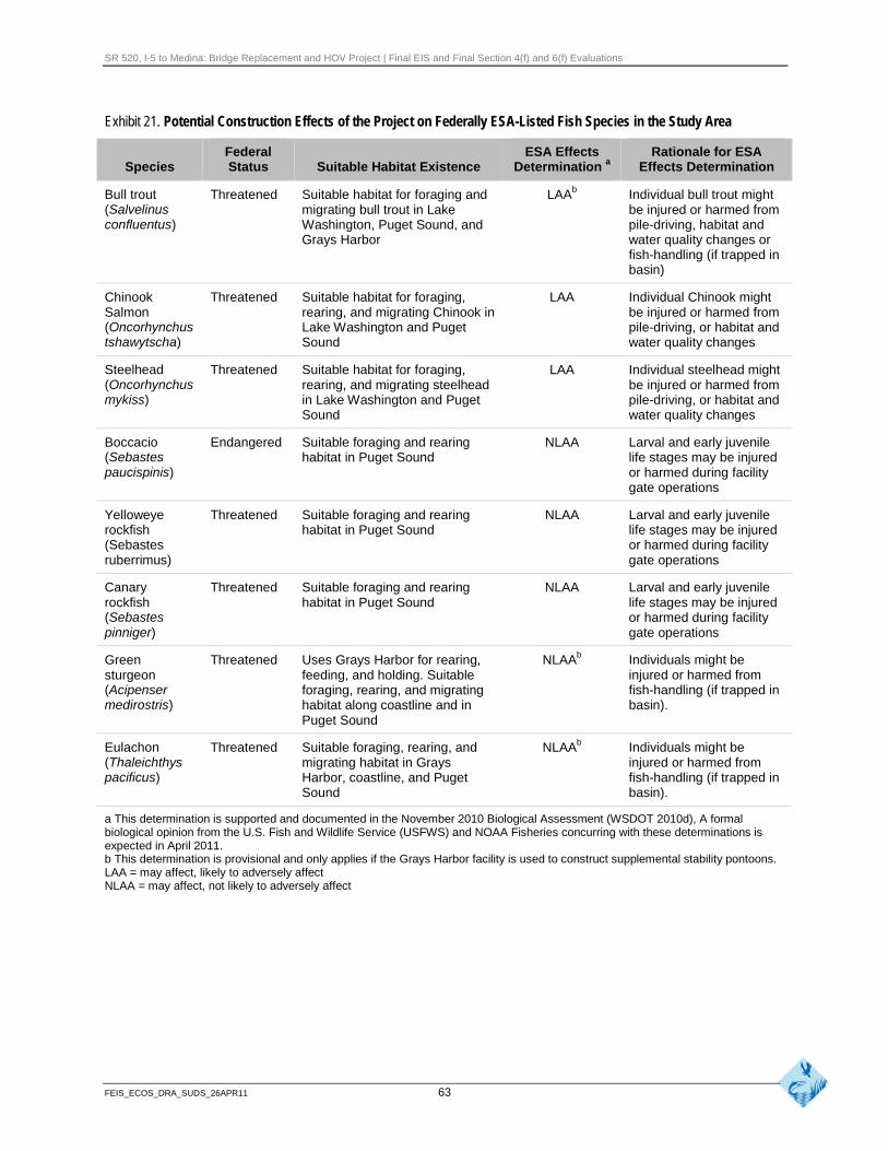
SR 520, I-5 to Medina: Bridge Replacement and HOV Project | Final EIS and Final Section 4(f) and 6(f) Evaluations
Exhibit 21. Potential Construction Effects of the Project on Federally ESA-Listed Fish Species in the Study Area
Federal ESA Effects Rationale for ESA Species Status Suitable Habitat Existence Determination a Effects Determination
Bull trout (Salvelinus confluentus)
Threatened Suitable habitat for foraging and migrating bull trout in Lake Washington, Puget Sound, and Grays Harbor
LAAb Individual bull trout might be injured or harmed from pile-driving, habitat and water quality changes or fish-handling (if trapped in basin)
Chinook Salmon (Oncorhynchus tshawytscha)
Threatened Suitable habitat for foraging, rearing, and migrating Chinook in Lake Washington and Puget Sound
LAA Individual Chinook might be injured or harmed from pile-driving, or habitat and water quality changes
Steelhead (Oncorhynchus mykiss)
Threatened Suitable habitat for foraging, rearing, and migrating steelhead in Lake Washington and Puget Sound
LAA Individual steelhead might be injured or harmed from pile-driving, or habitat and water quality changes
Boccacio (Sebastes paucispinis)
Endangered Suitable foraging and rearing habitat in Puget Sound
NLAA Larval and early juvenile life stages may be injured or harmed during facility gate operations
Yelloweye rockfish (Sebastes ruberrimus)
Threatened Suitable foraging and rearing habitat in Puget Sound
NLAA Larval and early juvenile life stages may be injured or harmed during facility gate operations
Canary rockfish (Sebastes pinniger)
Threatened Suitable foraging and rearing habitat in Puget Sound
NLAA Larval and early juvenile life stages may be injured or harmed during facility gate operations
Green sturgeon (Acipenser medirostris)
Threatened Uses Grays Harbor for rearing, feeding, and holding. Suitable foraging, rearing, and migrating habitat along coastline and in Puget Sound
NLAAb Individuals might be injured or harmed from fish-handling (if trapped in basin).
Eulachon (Thaleichthys pacificus)
Threatened Suitable foraging, rearing, and migrating habitat in Grays Harbor, coastline, and Puget Sound
NLAAb Individuals might be injured or harmed from fish-handling (if trapped in basin).
a This determination is supported and documented in the November 2010 Biological Assessment (WSDOT 2010d), A formal biological opinion from the U.S. Fish and Wildlife Service (USFWS) and NOAA Fisheries concurring with these determinations is expected in April 2011. b This determination is provisional and only applies if the Grays Harbor facility is used to construct supplemental stability pontoons. LAA = may affect, likely to adversely affect NLAA = may affect, not likely to adversely affect
FEIS_ECOS_DRA_SUDS_26APR11 63
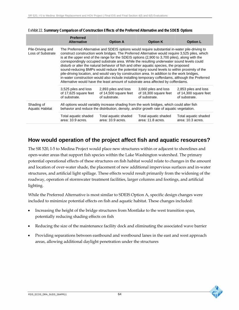
SR 520, I-5 to Medina: Bridge Replacement and HOV Project | Final EIS and Final Section 4(f) and 6(f) Evaluations
Exhibit 22. Summary Comparison of Construction Effects of the Preferred Alternative and the SDEIS Options
Preferred Alternative Option A Option K Option L
Pile-Driving and Loss of Substrate
The Preferred Alternative and SDEIS options would require substantial in-water pile-driving to construct construction work bridges. The Preferred Alternative would require 3,525 piles, which is at the upper end of the range for the SDEIS options (2,900 to 3,700 piles), along with the correspondingly occupied substrate area. While the resulting underwater sound levels could disturb or alter the natural behavior of fish and other aquatic species, the proposed sound-reducing BMPs would reduce the potential injury sound levels to within proximity of the pile-driving location, and would vary by construction area. In addition to the work bridges, in-water construction would also include installing temporary cofferdams, although the Preferred Alternative would have the least amount of substrate area affected by cofferdams.
3,525 piles and loss of 17,625 square feet of substrate.
2,893 piles and loss of 14,500 square feet of substrate.
3,660 piles and loss of 18,300 square feet of substrate.
2,853 piles and loss of 14,300 square feet of substrate.
Shading of Aquatic Habitat
All options would variably increase shading from the work bridges, which could alter fish behavior and reduce the distribution, density, and/or growth rate of aquatic vegetation.
Total aquatic shaded area: 10.9 acres.
Total aquatic shaded area: 10.9 acres.
Total aquatic shaded area: 11.8 acres.
Total aquatic shaded area: 10.3 acres.
How would operation of the project affect fish and aquatic resources?
The SR 520, I-5 to Medina Project would place new structures within or adjacent to shorelines and open-water areas that support fish species within the Lake Washington watershed. The primary potential operational effects of these structures on fish habitat would relate to changes in the amount and location of over-water shade, the placement of new additional impervious surfaces and in-water structures, and artificial light spillage. These effects would result primarily from the widening of the roadway, operation of stormwater treatment facilities, larger columns and footings, and artificial lighting.
While the Preferred Alternative is most similar to SDEIS Option A, specific design changes were included to minimize potential effects on fish and aquatic habitat. These changes included:
Increasing the height of the bridge structures from Montlake to the west transition span, potentially reducing shading effects on fish
Reducing the size of the maintenance facility dock and eliminating the associated wave barrier
Providing separations between eastbound and westbound lanes in the east and west approach areas, allowing additional daylight penetration under the structures
FEIS_ECOS_DRA_SUDS_26APR11 64
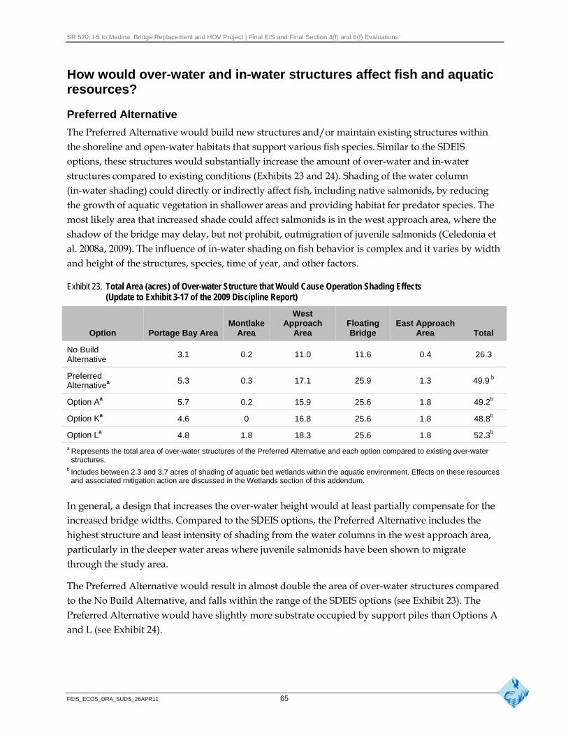
SR 520, I-5 to Medina: Bridge Replacement and HOV Project | Final EIS and Final Section 4(f) and 6(f) Evaluations
How would over-water and in-water structures affect fish and aquaticresources?
Preferred Alternative
The Preferred Alternative would build new structures and/or maintain existing structures within the shoreline and open-water habitats that support various fish species. Similar to the SDEIS options, these structures would substantially increase the amount of over-water and in-water structures compared to existing conditions (Exhibits 23 and 24). Shading of the water column (in-water shading) could directly or indirectly affect fish, including native salmonids, by reducing the growth of aquatic vegetation in shallower areas and providing habitat for predator species. The most likely area that increased shade could affect salmonids is in the west approach area, where the shadow of the bridge may delay, but not prohibit, outmigration of juvenile salmonids (Celedonia et al. 2008a, 2009). The influence of in-water shading on fish behavior is complex and it varies by width and height of the structures, species, time of year, and other factors.
Exhibit 23. Total Area (acres) of Over-water Structure that Would Cause Operation Shading Effects (Update to Exhibit 3-17 of the 2009 Discipline Report)
West
Option Portage Bay Area Montlake
Area Approach
Area Floating Bridge
East Approach Area Total
No Build Alternative
3.1 0.2 11.0 11.6 0.4 26.3
Preferred Alternativea 5.3 0.3 17.1 25.9 1.3 49.9 b
Option Aa 5.7 0.2 15.9 25.6 1.8 49.2b
Option Ka 4.6 0 16.8 25.6 1.8 48.8b
Option La 4.8 1.8 18.3 25.6 1.8 52.3b
a Represents the total area of over-water structures of the Preferred Alternative and each option compared to existing over-water structures.
b Includes between 2.3 and 3.7 acres of shading of aquatic bed wetlands within the aquatic environment. Effects on these resources and associated mitigation action are discussed in the Wetlands section of this addendum.
In general, a design that increases the over-water height would at least partially compensate for the increased bridge widths. Compared to the SDEIS options, the Preferred Alternative includes the highest structure and least intensity of shading from the water columns in the west approach area, particularly in the deeper water areas where juvenile salmonids have been shown to migrate through the study area.
The Preferred Alternative would result in almost double the area of over-water structures compared to the No Build Alternative, and falls within the range of the SDEIS options (see Exhibit 23). The Preferred Alternative would have slightly more substrate occupied by support piles than Options A and L (see Exhibit 24).
FEIS_ECOS_DRA_SUDS_26APR11 65
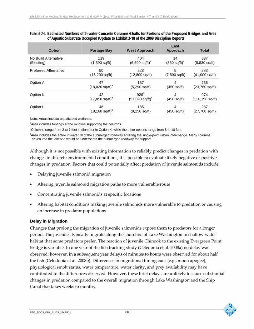
SR 520, I-5 to Medina: Bridge Replacement and HOV Project | Final EIS and Final Section 4(f) and 6(f) Evaluations
Exhibit 24. Estimated Numbers of In-water Concrete Columns/Shafts for Portions of the Proposed Bridges and Area of Aquatic Substrate Occupied (Update to Exhibit 3-18 of the 2009 Discipline Report)
East Option Portage Bay West Approach Approach Total
No Build Alternative 119 404 14 537 (Existing) (1,890 sq/ft) (6,590 sq/ft)a (350 sq/ft)a (8,830 sq/ft)
Preferred Alternative 50 228 5 283 (15,200 sq/ft) (12,800 sq/ft) (7,800 sq/ft) (41,000 sq/ft)
Option A 47 (18,020 sq/ft)a
187 (5,290 sq/ft)
4 (450 sq/ft)
238 (23,760 sq/ft)
Option K 42 (17,850 sq/ft)a
928b
(97,890 sq/ft)c 4
(450 sq/ft) 974
(116,190 sq/ft)
Option L 48 (18,160 sq/ft)a
185 (9,150 sq/ft)
4 (450 sq/ft)
237 (27,760 sq/ft)
Note: Areas include aquatic bed wetlands. aArea includes footings at the mudline supporting the columns. bColumns range from 2 to 7 feet in diameter in Option K, while the other options range from 6 to 10 feet. cArea includes the entire in-water fill of the submerged roadway entering the single-point urban interchange. Many columns
driven into the lakebed would be underneath the submerged roadway for support.
Although it is not possible with existing information to reliably predict changes in predation with changes in discrete environmental conditions, it is possible to evaluate likely negative or positive changes in predation. Factors that could potentially affect predation of juvenile salmonids include:
Delaying juvenile salmonid migration
Altering juvenile salmonid migration paths to more vulnerable route
Concentrating juvenile salmonids at specific locations
Altering habitat conditions making juvenile salmonids more vulnerable to predation or causing an increase in predator populations
Delay in Migration
Changes that prolong the migration of juvenile salmonids expose them to predators for a longer period. The juveniles typically migrate along the shoreline of Lake Washington in shallow-water habitat that some predators prefer. The reaction of juvenile Chinook to the existing Evergreen Point Bridge is variable. In one year of the fish tracking study (Celedonia et al. 2008a) no delay was observed; however, in a subsequent year delays of minutes to hours were observed for about half the fish (Celedonia et al. 2008b). Differences in migrational timing cues (e.g., moon apogee), physiological smolt status, water temperature, water clarity, and prey availability may have contributed to the differences observed. However, these brief delays are unlikely to cause substantial changes in predation compared to the overall migration through Lake Washington and the Ship Canal that takes weeks to months.
FEIS_ECOS_DRA_SUDS_26APR11 66
SR 520, I-5 to Medina: Bridge Replacement and HOV Project | Final EIS and Final Section 4(f) and 6(f) Evaluations
Altered Migration Paths
Altering the migration path of juvenile salmon may make them more or less vulnerable to predation. Juvenile salmon tend to select migration routes that provide some refuge from predation such as shallow water. However, actively migrating juvenile salmonids tend to use much more of the available habitat. Available information indicates that the existing Evergreen Point Bridge does not substantially alter migration paths for juvenile salmonids. However, Celedonia et al. (2008b, 2009) observed modifications in tagged fish behavior near the bridge where some tagged fish paused or moved along the edge of the bridge before eventually passing under it. This back-and-forth movement under the existing bridge and their general movement away from the shoreline indicate that juvenile salmon do react to the bridge.
Concentration of Juvenile Salmonids
Concentration of juvenile salmon at a particular location during migration has the potential to attract predators and increase predation rates. Juvenile salmon, particularly Chinook, may potentially congregate as they encounter physical obstacles such as docks and bridges. Although recent tracking (Celedonia et al. 2008a, 2008b, 2009) did not show concentrations of juvenile Chinook at any specific location near the existing bridge, some fish do use the bridge as structural cover. Celedonia et al. (2009) found that 65 percent of the tagged Chinook delayed for an average of 10 minutes near the existing bridge. Juveniles also tended to spend more time at night near bridge lights than in the areas between lights. However, no evidence indicated that the fish were sufficiently concentrated to attract predators. In addition, tracking data from Celedonia (2009) indicated that the abundance of two primary salmonid predators, smallmouth bass and northern pikeminnow, were comparable at the bridge site to four reference sites located away from the bridge, suggesting that abundances are not elevated near the bridge.
Altered Habitat Conditions
The new Evergreen Point Bridge would produce general in-water habitat conditions similar to existing conditions. The new bridge would be higher above the water in places, supported by fewer but larger columns. The net result would be incremental changes to the lake’s habitat where the juvenile salmon migrate under the bridge. Reduced shading and the increased height of the bridge is likely to decrease the reaction of juvenile salmon to the bridge in the west approach area. In conclusion, because the existing bridge appears to cause only brief migration delays and no substantial predation, the minor changes associated with the increased height and width of the new structure would not likely increase predation. This conclusion assumes that the existing bridge and its support columns would be removed to the lake’s mudline, leaving no structures that would affect predators or juvenile salmon.
Portage Bay
The Preferred Alternative would result in about 5.3 acres of over-water bridge deck for the Portage Bay Bridge, which is about 2.2 acres more than the existing conditions and within the range (4.6 to 5.7 acres) estimated for the SDEIS options (see Exhibit 23).
FEIS_ECOS_DRA_SUDS_26APR11 67
SR 520, I-5 to Medina: Bridge Replacement and HOV Project | Final EIS and Final Section 4(f) and 6(f) Evaluations
The proposed Portage Bay Bridge would have a minimum width of approximately 105 feet and be at least 40 feet wider than the existing bridge. The Portage Bay Bridge deck (road grade) would be approximately the same height as the existing roadway on the western half of the bridge, but approximately 10 feet higher on the eastern half than the existing bridge (typically between 18 and 24 feet above the water). As a result, the eastern portion of the proposed bridge would cast less intense shadows on the water surface and have less potential effects on fish (see Exhibit 14).
The 50 permanent columns of the Preferred Alternative would replace the 89 in-water columns currently supporting the Portage Bay Bridge. This is a slight increase from the number of columns identified for the SDEIS options (42 to 48), due primarily to increasing the number of columns at each support pier from 4 to 5. The mudline footings constructed in Portage Bay to support the tallest portions of the proposed bridge would occur at the three westernmost in-water piers. Each footing would be supported by 10 drilled shafts and provide support for five permanent bridge columns. By comparison, the SDEIS options have more footings (14 total), but are smaller (typically 37 by 37 feet) and support two columns each. The Preferred Alternative would result in about 0.1 acre less combined total area occupied by the footings than for the SDEIS options.
The Preferred Alternative would have less than half the number of in-water columns as the existing bridge, but a substantially greater overall footprint due to the larger column diameters and the three mudline footings (Exhibit 24). The substrate displacement for the Preferred Alternative would be less than the SDEIS options.
Montlake Area
The Preferred Alternative would include a new bascule bridge across the Montlake Cut, constructed perpendicular to the Montlake Cut and parallel to the existing bridge. While the existing bridge has a grated deck, the deck design of the new bascule bridge has not been finalized. A grated deck would result in greater light penetration under the structure than a solid concrete deck, resulting in a less defined shadow on the water surface, which could affect the migration rate of juvenile salmonids passing through the Montlake Cut. However, the overall height of the bridge (40 to 50 feet) would minimize the intensity of the shaded area. Overall, the new bascule bridge would result in 1.8 acres of additional shading, similar to SDEIS Option A.
West Approach Area
For the Preferred Alternative, the proposed bridge would be higher above the water throughout much of the west approach than the existing bridge or the SDEIS options. Combined with the fewer (but larger) in-water columns, the higher bridge would allow greater amounts of light under the bridge, effectively reducing the intensity of the overall shaded area and the shade edge. These reductions in shade intensity would minimize the effects of shade on fish and other aquatic species compared to the SDEIS options and existing conditions.
The west approach would be approximately 57 feet wider than the existing bridge. The new bridge would be up to 32 feet higher than the existing bridge, with the greatest difference in the area east of
FEIS_ECOS_DRA_SUDS_26APR11 68

SR 520, I-5 to Medina: Bridge Replacement and HOV Project | Final EIS and Final Section 4(f) and 6(f) Evaluations
Foster Island, which is a primary migration route of juvenile salmonids. The west approach would also have a higher profile than the SDEIS options. The increased height and wider spacing between the eastbound and westbound bridge structures would reduce the shading effects from the wider bridge. For the Preferred Alternative the distance between the bridge structures ranges between 7 and 20 feet, whereas the SDEIS options structures were generally less than 10 feet apart.
Under the Preferred Alternative, the west approach would result in nearly half the number of support columns in the water compared to existing conditions (see Exhibit 24). In addition, the spacing between the support columns would typically increase between 50 and 100 percent, which would substantially increase the open habitat area between the structures and thereby minimize the potential for predators to use the structures to ambush juvenile salmonids.
The height and shade variables, the reduced number of in-water structures, and the increased spacing between in-water structures would reduce overall habitat complexity per unit area and would likely decrease the predation rates along the migratory corridor.
Lake Washington
For the Preferred Alternative, the floating portion of the Evergreen Point Bridge would be the same as the SDEIS options. It would be built over deep open-water habitat where bridge columns are not feasible and it would be anchored in place between 160 and 190 feet north of the existing bridge. The roadway above the pontoons would be supported by concrete columns and steel trusses, and the new bridge structure would be approximately 13 feet higher and approximately twice as wide as the existing floating bridge. The Preferred Alternative roadway height is about 10 feet lower than the SDEIS options, but this reduction is not expected to substantially affect fish because only the superstructure would be different. The area of the floating bridge would be about 25.9 acres, which is similar to the SDEIS options (see Exhibit 23).
Fish react to the presence of over-water and in-water structures. Fish are expected to react similarly to the proposed bridge as to the existing bridge. The increased draft from the pontoons and the areas between the supplemental stability pontoons could affect fish use of the area near the bridge.
Celedonia et al. (2008a, 2009) recently evaluated the migratory behavior of juvenile Chinook salmon along the western shoreline of the lake. They found that fish that were rearing and not actively migrating appeared to selectively choose to reside in areas near the bridge for prolonged periods, typically within about 65 feet of the bridge edge. These fish may have been using the shadow or the bridge structure as cover. Only one salmonid species (Chinook salmon) was studied but other variables could be evaluated, including fish origin (hatchery versus naturally spawned fish), seasonal effects (early season migration versus late season migration), and migration path location (fish were released only near the west approach). Despite the potential unknowns, this study represents the best available science on juvenile salmon outmigration in the study area.
The existing Evergreen Point Bridge impedes the movement of wind-driven Lake Washington surface water. The force of northerly or southerly winds tends to increase the height of the water
FEIS_ECOS_DRA_SUDS_26APR11 69
SR 520, I-5 to Medina: Bridge Replacement and HOV Project | Final EIS and Final Section 4(f) and 6(f) Evaluations
slightly on the upwind side of the floating bridge, thus forcing a small movement of water under and around the ends of the bridge. However, calculated velocities of this water movement, even under the worst-case scenario of a 100-year design storm, would not be of a sufficient magnitude to substantially affect fish migration (WSDOT 2009e).
The new floating portion of the bridge would be about 132 feet longer than the existing floating span, and the depth (draft) of the new pontoons would increase to 14 to 18 feet. However, based on the relatively small magnitude of the increase and considering the overall lake volume, the increased size of the new pontoon structures would not be expected to substantially decrease the flow of wind-driven water past the floating bridge from the existing condition. The increased draft, in combination with the variable spacing of the supplemental stability pontoons along the longitudinal pontoons, could result in localized circulation patterns. The variable spacing would produce periodic recesses along the face of the pontoons, which would substantially increase the migration distance if fish followed the face of the pontoons. However, these recesses could also provide additional deepwater forage habitat for fish using the edge of the pontoons as cover.
East Approach Area
The design of the east approach has been refined since the publication of the SDEIS. For the Preferred Alternative the five in-water columns would be supported by two mudline footings rather than each of the bridge columns supported by individual drilled shaft foundations. This design would displace about 7,800 square feet of substrate, compared to 450 square feet described in the SDEIS, and would likely increase the loss of sockeye spawning habitat in this area.
The new east approach would be higher for the Preferred Alternative and the SDEIS options than the existing structure by approximately 13 feet along the majority of its length. However, the Preferred Alternative structure would cover a slightly wider area than the SDEIS options, because there would be a wider gap between the eastbound and westbound lanes. While this gap would increase the overall width of the east approach, it would allow greater light penetration, potentially decreasing the shading effects. It is not expected that the 70-foot high bridge structure would shade the areas such that it would affect the spawning of sockeye salmon, even if appropriate spawning conditions were present. The east approach would result in 1.3 acres of over-water shade for the Preferred Alternative compared to 1.8 acres for the SDEIS options (see Exhibits 23 and 24).
Bridge Maintenance Facility
The bridge maintenance facility would be located under the east approach and would consist of an upland facility and a dock extending approximately 100 feet offshore. The maintenance facility dock would add over-water structure in the shallow nearshore environment, which could affect the migration and rearing behavior of juvenile salmonids. It could also create habitat for smallmouth bass and other predators of juvenile salmonids. There would also be a small loss of bottom habitat from the support columns.
FEIS_ECOS_DRA_SUDS_26APR11 70
SR 520, I-5 to Medina: Bridge Replacement and HOV Project | Final EIS and Final Section 4(f) and 6(f) Evaluations
The modified T-shaped dock design includes a 10-foot-wide main stem extending about 100 feet from the shoreline. The modified T-portion would be approximately 50 feet long (north-south direction). This design change would apply to the SDEIS options as well as the Preferred Alternative and would reduce the width of the main stem dock from 14 to 10 feet. The dock would still be supported by four columns, set between 40 and 50 feet apart. Three 3-foot-diameter columns would be supported by 5- or 6-foot-diameter drilled shafts, while the fourth column would be 4 feet in diameter and supported by a 7-foot-diameter drilled shaft.
Based on input from resource agencies, the dock designed for the Preferred Alternative eliminated the use of a wave barrier to provide protection for the maintenance vessels, including the potential effects of such a structure on aquatic habitat. The wave barrier for the SDEIS options was located on the south side of the outer end of the dock. Although the wave barrier did not extend to the lake bottom, the changes in hydrodynamic flow patterns were expected to cause some redistribution of substrate material in the immediate area, and alter the size and intensity of waves along a portion of the shoreline. Changes in substrate characteristics could have positively or negatively altered the suitability of the area for use by beach spawning sockeye. By eliminating the wave barrier, the refined dock design would likely have fewer effects on spawning habitat, although the drilled support shafts could occupy about 35 square feet of substrate that is assumed to provide existing spawning habitat. It is assumed that this dock design would be the same for any of the SDEIS options, if they were identified as the Preferred Alternative.
The refined main stem dock design slopes downward from about 6 feet above the normal high lake elevation (18.7 feet [North American Vertical Datum 88]) at the shoreline to about 0.7 feet above this elevation at the mooring dock. This configuration is different from the dock design for the SDEIS options, which consisted of a level main stem dock at about 28 feet above the water surface, and a lower mooring dock at the normal low lake elevation (16.7 feet).
The refined dock design eliminates all but two luminaires (overhead light stanchion) on the maintenance dock, compared to the design described in the SDEIS. The other luminaires would be replaced with low-level path lighting to minimize the amount of incident light reaching the water surface. The two remaining luminaires would be on the far end of the dock, about 100 feet from shore, and at the shoreline.
Eastside Transition Area
As with the SDEIS options, the Preferred Alternative would have no operational effects on aquatic habitat in the Eastside transition area.
How would operational lighting affect fish?
As with the SDEIS options, the Preferred Alternative would have roadway luminaires on only portions of the fixed bridge structures and safety lighting on the maintenance facility dock under the east approach, but no highway luminaires on the floating bridge. Similar to the other options, the Preferred Alternative would include highway lighting only as required by WSDOT and FHWA
FEIS_ECOS_DRA_SUDS_26APR11 71
SR 520, I-5 to Medina: Bridge Replacement and HOV Project | Final EIS and Final Section 4(f) and 6(f) Evaluations
roadway safety guidelines. This would include luminaires across Portage Bay and the Arboretum portions of the project alignment, which is a substantial reduction compared to existing lights that extend across the entire bridge. Continuous pedestrian lighting would be provided across the entire structure for the proposed pedestrian/bicycle path. All of the proposed highway luminaires would be shielded and the bulbs would be 250 watts, as compared to the WSDOT standard of 400-watt bulbs. Therefore, the proposed condition would maintain or reduce the potential effects on fish and other aquatic species from operational lighting.
The lights on over-water structures could affect the distribution of juvenile salmonids and potential predators, although the generally higher elevation of most of the bridge compared to existing conditions would further reduce the amount of artificial light reaching the water. If predators were attracted to the maintenance facility dock and the additional lighting also attracted juvenile salmonids, the rate of predation of these salmonids could increase compared to existing conditions. However, design refinements to the Preferred Alternative yielded fewer overhead luminaires compared to design described in the SDEIS.
How would operation of the project affect water quality?
The Major Lakes Monitoring Program conducted by King County includes several stations within the study area (King County 2010). Analyses of dissolved oxygen, phosphorus, temperature, and pH data from three of these monitoring stations are presented in the Water Resources Discipline Report Addendum and Errata (WSDOT 2011c), because they occur near a primary salmonid migration corridor in Lake Washington and in the Ship Canal.
At all three monitoring stations, dissolved oxygen, phosphorus, temperature, and pH failed to comply with water quality standards established for salmonid spawning, rearing, and migration at least some of the time over the multi-year monitoring period. While this result indicates that the overall water quality of Lake Washington shows some level of impairment, the proposed project is not likely to contribute to these pollutant exceedances because highway runoff is not a source of biochemical oxygen demand (the term for substances that decrease dissolved oxygen), phosphorus, or pH. Similarly, highway runoff is unlikely to detectably increase in surface water temperatures in Portage Bay, the Montlake Cut, or Lake Washington (see the Water Resources Discipline Report Addendum and Errata [WSDOT 2011c]).
The long-term record (1964 to 1998) of inter-annual temperature changes in Lake Washington has been analyzed by Arhonditsis et al. (2004). They found that the lake has been experiencing a warming trend for this 34-year period leading to an increase of 1.5°C weighted over the lake surface (0 to 10 meters below the water surface). Although it is unclear if the trend is continuing, maximum temperatures have exceeded state standards since the 1998 peak used in the 2004 analysis (see the Water Resources Discipline Report Addendum and Errata [WSDOT 2011c]).
Stormwater that runs off the SR 520 highway within the project vicinity is currently not treated before it is discharged into Lake Washington, Lake Union, and Portage Bay. As with the SDEIS options, the Preferred Alternative would treat all stormwater from new and replaced impervious
FEIS_ECOS_DRA_SUDS_26APR11 72
SR 520, I-5 to Medina: Bridge Replacement and HOV Project | Final EIS and Final Section 4(f) and 6(f) Evaluations
surfaces before being discharged into these water bodies. The Preferred Alternative would be designed in accordance with the 2008 Highway Runoff Manual (WSDOT 2008), and WSDOT would provide enhanced stormwater treatment, where feasible and practical.
Two design scenarios for the Preferred Alternative were analyzed to determine if the pattern of precipitation (such as high winds blowing water under lids) would increase the amount of pollutants washed off roadways and other PGIS into adjacent water bodies. Lid Scenario 1 includes the entire SR 520 roadway but does not include the areas under SR 520 that are associated with the landscaped lids at 10th Avenue East and Delmar Drive East and in the Montlake area. Lid Scenario 2 includes both the SR 520 roadway areas and the areas under the two lids, to the extent that rain falling at an angle of 30 degrees would be able to wash pollutants off these surfaces and into the stormwater conveyance and treatment system. Either Lid Scenario 1 or Lid Scenario 2 would treat more PGIS after construction than existing conditions but less than the SDEIS options (Exhibit 25). Additional information is presented in the Water Resources Discipline Report Addendum and Errata (WSDOT 2011c).
The differences in pollutant loading of the Preferred Alternative scenarios from the No Build Alternative are described below and listed in Exhibit 25.
The net pollution reductions reported in Exhibit 25 would be achieved primarily as a consequence of the project adding stormwater treatment facilities for a large amount of existing pavement that currently goes untreated. This reduction is greater than the
What are pollution-generating increase in pollutant loads resulting from the creation of new PGIS impervious surfaces (PGIS)?
by the project. (Because stormwater treatment systems are all less Impervious surfaces are structures that than 100 percent effective in removing pollutants, adding new prevent rain from naturally penetrating
into the soil (such as sidewalks and PGIS will always increase the pollutant load for each acre added.) road surfaces). Pollution-generating
surfaces are those that have pollutants, This project would achieve an overall net reduction by treating such as grease and oil from
automobiles. sufficient acreage of untreated stormwater on existing PGIS to offset the increased pollutant load associated with the new PGIS.
The patterns of net changes in pollutants loads were generally the same for the Preferred Alternative as for the three SDEIS options. For the total study area, the Preferred Alternative and the three SDEIS options show a predicted net reduction for all five stormwater pollutants compared with the No Build Alternative. The differences in net reduction between the Preferred Alternative and SDEIS options are slight, with either Option A, K, or L showing the greatest reduction in pollutant load for each evaluated pollutant. Overall, the Preferred Alternative had a somewhat lower net reduction in pollutant load for total suspended solids, total and dissolved zinc, and total copper than any of the SDEIS options. This is because the SDEIS options treated more existing PGIS than is currently untreated. project-wide, the net reduction in dissolved copper was essentially the same for the Preferred Alternative and the three SDEIS options.
FEIS_ECOS_DRA_SUDS_26APR11 73
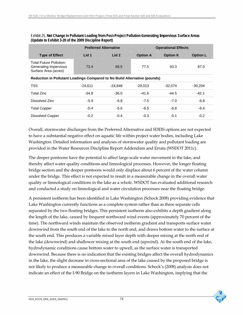
SR 520, I-5 to Medina: Bridge Replacement and HOV Project | Final EIS and Final Section 4(f) and 6(f) Evaluations
Exhibit 25. Net Change in Pollutant Loading from Post-Project Pollution-Generating Impervious Surface Areas (Update to Exhibit 3-20 of the 2009 Discipline Report)
Preferred Alternative Operational Effects
Type of Effect Lid 1 Lid 2 Option A Option K Option L
Total Future Pollution-Generating Impervious Surface Area (acres)
73.4 68.5 77.5 93.3 87.0
Reduction in Pollutant Loadings Compared to No Build Alternative (pounds)
TSS -24,611 -24,848 -29,013 -32,074 -30,204
Total Zinc -34.8 -36.0 -41.6 -44.5 -42.1
Dissolved Zinc -5.9 -6.8 -7.5 -7.0 -6.8
Total Copper -5.4 -5.6 -6.5 -6.8 -6.4
Dissolved Copper -0.2 -0.4 -0.3 -0.1 -0.2
Overall, stormwater discharges from the Preferred Alternative and SDEIS options are not expected to have a substantial negative effect on aquatic life within project water bodies, including Lake Washington. Detailed information and analyses of stormwater quality and pollutant loading are provided in the Water Resources Discipline Report Addendum and Errata (WSDOT 2011c).
The deeper pontoons have the potential to affect large-scale water movement in the lake, and thereby affect water quality conditions and limnological processes. However, the longer floating bridge section and the deeper pontoons would only displace about 6 percent of the water column under the bridge. This effect is not expected to result in a measurable change in the overall water quality or limnological conditions in the lake as a whole. WSDOT has evaluated additional research and conducted a study on limnological and water circulation processes near the floating bridge.
A persistent isotherm has been identified in Lake Washington (Schock 2008) providing evidence that Lake Washington currently functions as a complete system rather than as three separate cells separated by the two floating bridges. This persistent isotherm also exhibits a depth gradient along the length of the lake, caused by frequent northward wind events (approximately 70 percent of the time). The northward winds maintain the observed isotherm gradient and transports surface water downwind from the south end of the lake to the north end, and draws bottom water to the surface at the south end. This produces a variable mixed layer depth with deeper mixing at the north end of the lake (downwind) and shallower mixing at the south end (upwind). At the south end of the lake, hydrodynamic conditions cause bottom water to upwell, as the surface water is transported downwind. Because there is no indication that the existing bridges affect the overall hydrodynamics in the lake, the slight decrease in cross-sectional area of the lake caused by the proposed bridge is not likely to produce a measurable change in overall conditions. Schock’s (2008) analysis does not indicate an effect of the I-90 Bridge on the isotherm layers in Lake Washington, implying that the
FEIS_ECOS_DRA_SUDS_26APR11 74
SR 520, I-5 to Medina: Bridge Replacement and HOV Project | Final EIS and Final Section 4(f) and 6(f) Evaluations
Evergreen Point Bridge is not restricting circulation or producing mixing of surface and deeper layers.
The small increase in shading due to the larger proposed bridge is unlikely to result in a detectable change in primary production in Lake Washington. The predicted negligible reductions in algal productivity based on the reduction in light associated with bridge shading is, in part, based on the pattern of mixing in Lake Washington. During the summer, Lake Washington stratifies into two layers based on temperature differences and then mixes in the late fall/early winter. This pattern of mixing ensures that nutrients and algae are well distributed over time. Coupled with the seasonal and long-term changes in temperature and cloud cover, the variation in chlorophyll a levels (a measure of algal mass and therefore productivity) is much greater than any reduction in photosynthesis that would result from shading from the new bridge, and as such, would be undetectable over the life-span of the bridge.
The changes in pontoon depth, bridge width, and operational procedures are not likely to measurably change the abundance of salmonid prey resources in the lake, or otherwise affect the food web throughout the greater lake ecosystem, although some changes could occur in the immediate vicinity of the bridge. However, even if changes occur and are negative, it is unlikely that fish would remain in the area for a long enough time to affect their overall growth or survival, given the generally high productivity over the entire lake. In addition, it does not appear that existing prey availability limits the growth or survival of juvenile salmonids in Lake Washington because some of the highest recorded juvenile sockeye growth rates have been observed in the lake since the existing bridge was constructed (Eggers 1978; Edmondson 1994). Koehler et al. (2006) also found that Lake Washington Chinook salmon exhibited exceptional growth compared with Chinook salmon from other studies. Celedonia et al. (2009) observed that tagged juvenile Chinook tended to stay near the surface of the lake and away from the immediate shoreline as they passed the Evergreen Point Bridge, where zooplankton is the basic prey resource for these fish.
In the context of the limnological processes occurring in Lake Washington, the replacement bridge would replicate the physical and habitat conditions of the existing bridge at a slightly larger scale. The small increase in the floating bridge length, together with the increased pontoon depth to about 21 to 29 feet, is not expected to change limnological conditions to an appreciable degree from existing conditions. The increased bridge dimensions are small compared to the overall size of the lake and the cross-sectional area of the lake at the bridge location.
In response to tribal concerns regarding lake circulation, WSDOT conducted a follow-up study on this topic with regional experts on Lake Washington limnology and fisheries. This study provided more information on the potential effects on lake circulation from the deeper, longer, and wider floating bridge. The study found that predicted effects on mixing of the surface and subsurface water layers are small compared to other natural processes, especially upwelling. These effects are not expected to change water temperatures in the surface layers nor influence salmonid temperature dependent processes, including juvenile growth rates, adult energy depletion, or juvenile competition with other planktivores.
FEIS_ECOS_DRA_SUDS_26APR11 75
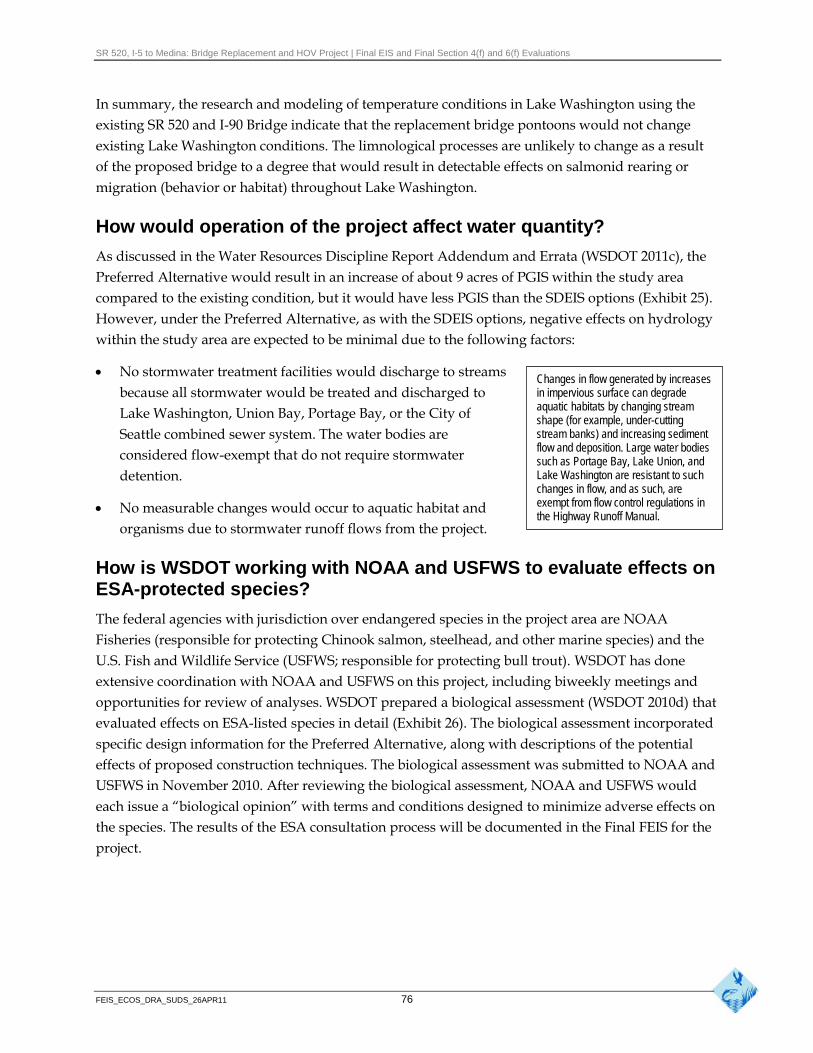
SR 520, I-5 to Medina: Bridge Replacement and HOV Project | Final EIS and Final Section 4(f) and 6(f) Evaluations
In summary, the research and modeling of temperature conditions in Lake Washington using the existing SR 520 and I-90 Bridge indicate that the replacement bridge pontoons would not change existing Lake Washington conditions. The limnological processes are unlikely to change as a result of the proposed bridge to a degree that would result in detectable effects on salmonid rearing or migration (behavior or habitat) throughout Lake Washington.
How would operation of the project affect water quantity?
As discussed in the Water Resources Discipline Report Addendum and Errata (WSDOT 2011c), the Preferred Alternative would result in an increase of about 9 acres of PGIS within the study area compared to the existing condition, but it would have less PGIS than the SDEIS options (Exhibit 25). However, under the Preferred Alternative, as with the SDEIS options, negative effects on hydrology within the study area are expected to be minimal due to the following factors:
No stormwater treatment facilities would discharge to streams Changes in flow generated by increases
because all stormwater would be treated and discharged to in impervious surface can degrade aquatic habitats by changing stream Lake Washington, Union Bay, Portage Bay, or the City of shape (for example, under-cutting
Seattle combined sewer system. The water bodies are stream banks) and increasing sediment flow and deposition. Large water bodies considered flow-exempt that do not require stormwater such as Portage Bay, Lake Union, and
detention. Lake Washington are resistant to such changes in flow, and as such, are exempt from flow control regulations in No measurable changes would occur to aquatic habitat and the Highway Runoff Manual.
organisms due to stormwater runoff flows from the project.
How is WSDOT working with NOAA and USFWS to evaluate effects on ESA-protected species?
The federal agencies with jurisdiction over endangered species in the project area are NOAA Fisheries (responsible for protecting Chinook salmon, steelhead, and other marine species) and the U.S. Fish and Wildlife Service (USFWS; responsible for protecting bull trout). WSDOT has done extensive coordination with NOAA and USFWS on this project, including biweekly meetings and opportunities for review of analyses. WSDOT prepared a biological assessment (WSDOT 2010d) that evaluated effects on ESA-listed species in detail (Exhibit 26). The biological assessment incorporated specific design information for the Preferred Alternative, along with descriptions of the potential effects of proposed construction techniques. The biological assessment was submitted to NOAA and USFWS in November 2010. After reviewing the biological assessment, NOAA and USFWS would each issue a “biological opinion” with terms and conditions designed to minimize adverse effects on the species. The results of the ESA consultation process will be documented in the Final FEIS for the project.
FEIS_ECOS_DRA_SUDS_26APR11 76

SR 520, I-5 to Medina: Bridge Replacement and HOV Project | Final EIS and Final Section 4(f) and 6(f) Evaluations
Exhibit 26. Potential Operational Effects of the Project on Federally ESA-Listed Fish Species in the Study Area
Federal ESA Effects Rationale for ESA Species Status Suitable Habitat Existence Determinationa Effects Determination
Bull trout Threatened Suitable habitat for foraging and LAA Individual bull trout might (Salvelinus migrating bull trout in Lake be injured or harmed by confluentus) Washington and Puget Sound habitat or water quality
changes.
Chinook Threatened Suitable habitat for foraging, LAA Individual Chinook might Salmon rearing, and migrating Chinook be injured or harmed by (Oncorhynchus in Lake Washington and Puget habitat or water quality tshawytscha) Sound changes.
Steelhead Threatened Suitable habitat for foraging, LAA Individual steelhead (Oncorhynchus rearing, and migrating steelhead might be injured or mykiss) in Lake Washington and Puget harmed by habitat or
Sound water quality changes.
a This determination is supported and documented in the November 2010 Biological Assessment (WSDOT 2010d). A formal biological opinion from USFWS and NOAA Fisheries concurring with these determinations is expected in April 2011. LAA = may affect, likely to adversely affect
How do the operational effects on fish and aquatic resources compare to the SDEIS options?
Exhibit 27 summarizes the project operation and permanent effects of the Preferred Alternative and the SDEIS options on fish and aquatic resources.
Exhibit 27. Summary Comparison of Operational Effects of the Preferred Alternative and the SDEIS Options
Preferred Alternative Option A Option K Option L
The Preferred Alternative and SDEIS options would result in overall water quality improvements based on providing some level of stormwater treatment to all stormwater for the project roadways. In contrast, there is only limited stormwater treatment under existing conditions.
The Preferred Alternative and SDEIS options would reduce fish habitat functions, primarily due to increased shading by the larger over-water structures. Compared to the existing structures, the proposed over-water structures are about twice as wide for the Preferred Alternative and SDEIS options, but would be substantially higher than the existing bridge. The Preferred Alternative is within the range of over-water shading identified for the SDEIS options.
The Preferred Alternative has Option A would result in Option K would result in Option L would result in a similar amount of over- more shading through 4.6 acres of shading 4.8 acres of shading water shading in Portage Portage Bay – 5.7 acres; through Portage Bay, but through Portage Bay. Bay – 5.3 acres, and the more than the Preferred would be below the Option L would be higher highest profile from Montlake Alternative and the other high-water elevation east than Option K, but lower through the west approach. SDEIS options. of the Montlake shoreline, than Option A through the
and much lower than the west approach. other options through Union Bay and east of Foster Island.
The Preferred Alternative Option A would fill Option K would fill Option L would fill would have a total in-water fill approximately approximately approximately of 41,000 square feet with 24,000 square feet of 117,000 square feet of 28,000 square feet of less in Portage Bay but more substrate. substrate. substrate. in the west approach and east approach than Option A.
FEIS_ECOS_DRA_SUDS_26APR11 77
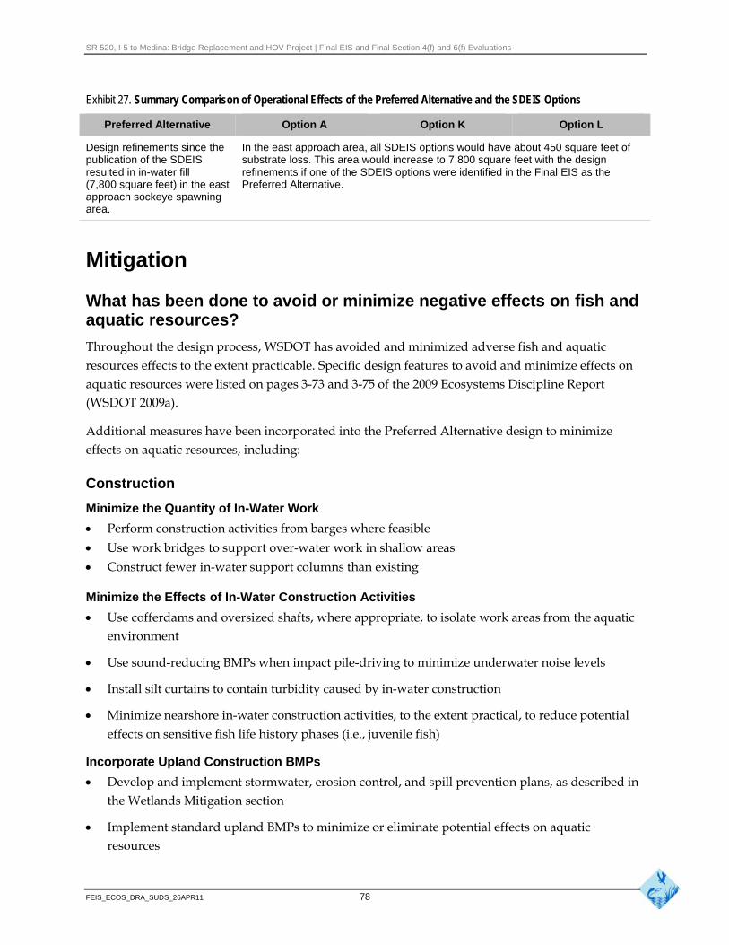
SR 520, I-5 to Medina: Bridge Replacement and HOV Project | Final EIS and Final Section 4(f) and 6(f) Evaluations
Exhibit 27. Summary Comparison of Operational Effects of the Preferred Alternative and the SDEIS Options
Preferred Alternative Option A Option K Option L
Design refinements since the In the east approach area, all SDEIS options would have about 450 square feet of publication of the SDEIS substrate loss. This area would increase to 7,800 square feet with the design resulted in in-water fill refinements if one of the SDEIS options were identified in the Final EIS as the (7,800 square feet) in the east Preferred Alternative. approach sockeye spawning area.
Mitigation
What has been done to avoid or minimize negative effects on fish and aquatic resources?
Throughout the design process, WSDOT has avoided and minimized adverse fish and aquatic resources effects to the extent practicable. Specific design features to avoid and minimize effects on aquatic resources were listed on pages 3-73 and 3-75 of the 2009 Ecosystems Discipline Report (WSDOT 2009a).
Additional measures have been incorporated into the Preferred Alternative design to minimize effects on aquatic resources, including:
Construction
Minimize the Quantity of In-Water Work
Perform construction activities from barges where feasible
Use work bridges to support over-water work in shallow areas
Construct fewer in-water support columns than existing
Minimize the Effects of In-Water Construction Activities
Use cofferdams and oversized shafts, where appropriate, to isolate work areas from the aquatic environment
Use sound-reducing BMPs when impact pile-driving to minimize underwater noise levels
Install silt curtains to contain turbidity caused by in-water construction
Minimize nearshore in-water construction activities, to the extent practical, to reduce potential effects on sensitive fish life history phases (i.e., juvenile fish)
Incorporate Upland Construction BMPs
Develop and implement stormwater, erosion control, and spill prevention plans, as described in the Wetlands Mitigation section
Implement standard upland BMPs to minimize or eliminate potential effects on aquatic resources
FEIS_ECOS_DRA_SUDS_26APR11 78
SR 520, I-5 to Medina: Bridge Replacement and HOV Project | Final EIS and Final Section 4(f) and 6(f) Evaluations
Operation
Minimize In-Water Fill by Reducing In-Water Structure
Minimize the number and size of in-water bridge support columns
Increase span length and column spacing from existing condition
Use mudline footings for structure foundations (reduces in-water structure)
Minimize Shading Effects on Open Water Habitat
Increase the height of the bridge structures compared to existing condition, and to SDEIS designs
Reduce the overall width of the over-water structures by minimizing number of lanes and shoulder widths in Portage Bay and portions of the west approach
Remove any unneeded over-water structures as soon as possible
A gap has been added between eastbound and westbound lanes of the west approach
Minimize Water Quality Effects on Aquatic Habitat
Collect and treat stormwater from new and replaced PGIS
Use enhanced stormwater treatment where possible
Minimize Lighting Effects on Aquatic Habitat
Cut-off light fixtures with shielding will be used when fixtures are adjacent to water
Lights will be placed on the center median whenever possible to limit light spillage
Nighttime lighting on water surfaces will be avoided or minimized where feasible
What would be done to mitigate negative effects that could not be avoided or minimized?
To fully compensate for project effects on aquatic resources, WSDOT engaged regulatory agencies and the Muckleshoot Indian Tribe in collaborative technical working groups to assist in the development of appropriate aquatic mitigation for project effects, and conducted a rigorous screening exercise to determine suitable sites to offset aquatic effects. A preliminary screening exercise for aquatic sites, documented in the Initial Aquatic Mitigation Report (WSDOT 2009g), consisted of a three-part process that screened all the potential parcels within the geographic study area (a large portion of the Lake Washington basin) down to a manageable number that still provided the types and quantity of aquatic functional lift to adequately compensate for the estimated effects of the project on aquatic resources. Seven sites were selected and ranked by potential to benefit aquatic resources. This Initial Aquatic Mitigation Report was prepared and submitted for agency review in October 2009.
Project mitigation was discussed in detail during the NRTWG meetings held from June to October 2010, which comprised regulatory agencies, the University of Washington, and the Muckleshoot Indian Tribe. The goal of the meetings was to review the sites proposed in the initial plan and to
FEIS_ECOS_DRA_SUDS_26APR11 79
SR 520, I-5 to Medina: Bridge Replacement and HOV Project | Final EIS and Final Section 4(f) and 6(f) Evaluations
identify additional sites that would appropriately mitigate for the types and amount of project effects. These sites underwent detailed analysis prior to inclusion in the Conceptual Aquatic Mitigation Plan (WSDOT 2011f). WSDOT is also coordinating with the tribe to develop appropriate mitigation measures for effects to tribal fishing. These measures will be documented in a separate agreement with the Muckleshoot Indian Tribe.
Comments on the initial plan were received and incorporated into the Conceptual Aquatic Mitigation Plan (WSDOT 2011f) for permit submittals in February 2011. This plan is attached to the Final EIS and is part of the permit applications. Project mitigation is summarized in Sections 5 and 6 of the Final EIS.
Compensatory mitigation is a component of the Preferred Alternative and the SDEIS options. Compensatory mitigation will be used to compensate for effects on fish and other aquatic resources from the increased in-water and over-water structures. The goal of the compensatory mitigation will be to achieve no net decrease in habitat function that affects fish survival.
WSDOT would conduct specific mitigation activities at several locations within the Water Resource Inventory Area (WRIA) 8 watershed, because the different types of potential project effects on fish and aquatic resources would occur in several distinct habitat types and fish life history stages (for example, outmigrating juvenile salmon versus shoreline spawning adults). The highly urbanized environment within the study area and Lake Washington, in general, influences the potential need for this type of mitigation strategy, which limits the number and sizes of available replacement sites along the lake. This approach had several advantages:
Multiple replacement sites would be designed to focus on enhancing and/or providing specific categories of aquatic functions and values affected by the project (for example, shoreline habitat functions).
Mitigation sites would be selected based on the life history requirements of important aquatic species (for example, salmonid migration) that may be affected by bridge construction and operation. Mitigation design compensates for these potential effects by improving previously identified limiting factors for these species.
Maintenance, monitoring, and adaptive management techniques would be tailored to the specific replacement site, based on the specific project objectives.
Several mitigation projects would be developed, including habitat restoration projects within Lake Washington, the Cedar River, and Bear Creek (see Exhibit 28). Although the specific fisheries
FEIS_ECOS_DRA_SUDS_26APR11 80
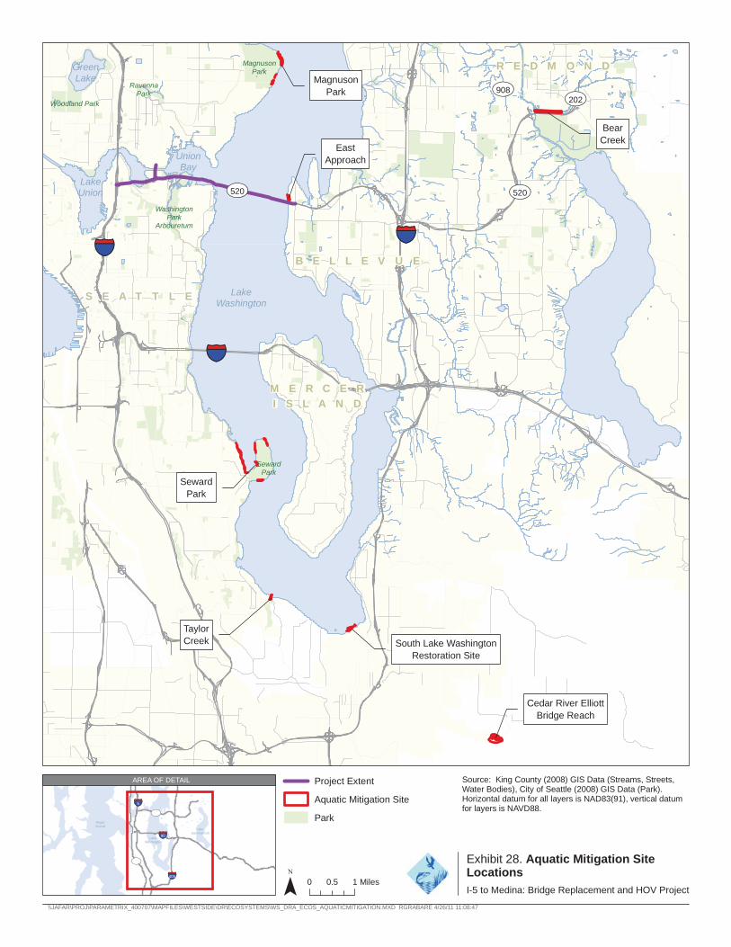
Green Lake
Woodland Park
Ravenna Park
Magnuson Park
Magnuson Park UV908
R E
UV202
D M O N D
Bear
East Creek
Union Bay
Approach
Lake Union UV520 UV520
Washington Park
Arbouretum
405
B E L L E V U E
Lake
§̈¦5
S E A T T L E
§̈¦
Washington
90
M E R C E R
I S L A N D
Seward Park
Seward Park
§̈¦
Taylor Creek South Lake Washington
Restoration Site
Cedar River Elliott Bridge Reach
AREA OF DETAIL Project Extent Source: King County (2008) GIS Data (Streams, Streets, Water Bodies), City of Seattle (2008) GIS Data (Park).
Aquatic Mitigation Site Horizontal datum for all layers is NAD83(91), vertical datum for layers is NAVD88.§̈¦5
Puget Sound
Lake
520 UV Park
§̈¦
§̈¦90
Washington
99 Exhibit 28. Aquatic Mitigation Site UVLocations 405
Sammamish
Lake
¯ 0 1 Miles 0.5 I-5 to Medina: Bridge Replacement and HOV Project
\\JAFAR\PROJ\PARAMETRIX_400707\MAPFILES\WESTSIDE\DR\ECOSYSTEMS\WS_DRA_ECOS_AQUATICMITIGATION.MXD RGRABARE 4/26/11 11:08:47
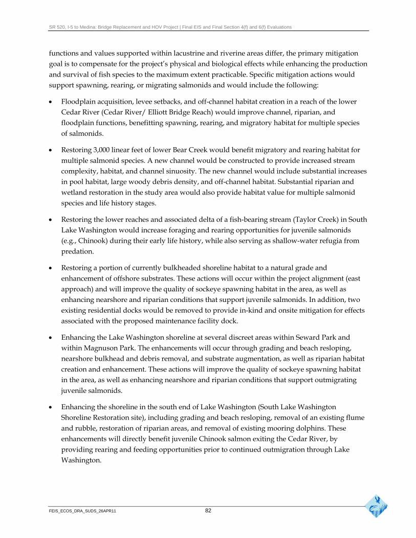
SR 520, I-5 to Medina: Bridge Replacement and HOV Project | Final EIS and Final Section 4(f) and 6(f) Evaluations
functions and values supported within lacustrine and riverine areas differ, the primary mitigation goal is to compensate for the project’s physical and biological effects while enhancing the production and survival of fish species to the maximum extent practicable. Specific mitigation actions would support spawning, rearing, or migrating salmonids and would include the following:
Floodplain acquisition, levee setbacks, and off-channel habitat creation in a reach of the lower Cedar River (Cedar River/ Elliott Bridge Reach) would improve channel, riparian, and floodplain functions, benefitting spawning, rearing, and migratory habitat for multiple species of salmonids.
Restoring 3,000 linear feet of lower Bear Creek would benefit migratory and rearing habitat for multiple salmonid species. A new channel would be constructed to provide increased stream complexity, habitat, and channel sinuosity. The new channel would include substantial increases in pool habitat, large woody debris density, and off-channel habitat. Substantial riparian and wetland restoration in the study area would also provide habitat value for multiple salmonid species and life history stages.
Restoring the lower reaches and associated delta of a fish-bearing stream (Taylor Creek) in South Lake Washington would increase foraging and rearing opportunities for juvenile salmonids (e.g., Chinook) during their early life history, while also serving as shallow-water refugia from predation.
Restoring a portion of currently bulkheaded shoreline habitat to a natural grade and enhancement of offshore substrates. These actions will occur within the project alignment (east approach) and will improve the quality of sockeye spawning habitat in the area, as well as enhancing nearshore and riparian conditions that support juvenile salmonids. In addition, two existing residential docks would be removed to provide in-kind and onsite mitigation for effects associated with the proposed maintenance facility dock.
Enhancing the Lake Washington shoreline at several discreet areas within Seward Park and within Magnuson Park. The enhancements will occur through grading and beach resloping, nearshore bulkhead and debris removal, and substrate augmentation, as well as riparian habitat creation and enhancement. These actions will improve the quality of sockeye spawning habitat in the area, as well as enhancing nearshore and riparian conditions that support outmigrating juvenile salmonids.
Enhancing the shoreline in the south end of Lake Washington (South Lake Washington Shoreline Restoration site), including grading and beach resloping, removal of an existing flume and rubble, restoration of riparian areas, and removal of existing mooring dolphins. These enhancements will directly benefit juvenile Chinook salmon exiting the Cedar River, by providing rearing and feeding opportunities prior to continued outmigration through Lake Washington.
FEIS_ECOS_DRA_SUDS_26APR11 82
SR 520, I-5 to Medina: Bridge Replacement and HOV Project | Final EIS and Final Section 4(f) and 6(f) Evaluations
What negative effects would remain after mitigation?
The mitigation approach is specifically designed to fully mitigate for all the negative effects of the project on aquatic resources.
Wildlife and Habitat
Affected Environment
What were the updates to the affected environment?
The WDFW Priority Habitats and Species database was reviewed since the publication of the SDEIS to determine if there have been any changes to the habitat associations and distribution of wildlife in the study area and vicinity (WDFW 2010). There were no updates to the Priority Habitats and Species database and no other updates to the affected environment for wildlife and habitat since preparation of the SDEIS analysis. Pages 4-1 to 4-19 of the 2009 Ecosystems Discipline Report (WSDOT 2009a) describe the affected environment.
The City of Seattle has developed standards for fish and wildlife habitat conservation areas within their shoreline management zone. Within the project corridor there is shoreline habitat, which is a type of fish and wildlife habitat conservation area (Seattle Municipal Code 25.09.200). The shoreline habitat has a 100-foot buffer landward from the OHWM.
On May 21 and 22, 2010, scientists, students, and volunteers attempted to inventory as many species as they could find in the Arboretum, concentrating their efforts on Foster Island (called a BioBlitz). The area they studied includes portions of the study area but also extends farther south. The BioBlitz was organized by the Washington Nature Mapping Program and the University of Washington Arboretum Foundation. The group counted plants, lichen, fungi, invertebrates, spiders, birds, mammals, amphibians, and reptiles. They counted numerous common species in addition to bald eagles, which are protected federally, and great blue heron, which is a state monitor species. Species numbers and additional data can be found on the NatureMapping Program Web site. Many of the observed species were previously identified in the 2009 Ecosystems Discipline Report (WSDOT 2009a).
Potential Effects
The Wildlife and Habitat section of the 2009 Ecosystems Discipline Report discusses in detail the effects of the No Build Alternative and Options A, K, and L (WSDOT 2009a, see pages 4-20 to 4-64). The discussion below supplements the Wildlife and Habitat section of the Ecosystems Discipline Report and compares the effects of the Preferred Alternative with the No Build Alternative and SDEIS options.
FEIS_ECOS_DRA_SUDS_26APR11 83
SR 520, I-5 to Medina: Bridge Replacement and HOV Project | Final EIS and Final Section 4(f) and 6(f) Evaluations
What were the methods used to evaluate the potential effects and howhave they changed since publication of the SDEIS?
The potential effects of the Preferred Alternative were evaluated using the same methods as those used to evaluate the potential effects of the No Build Alternative and SDEIS options (see page 4-20 of the 2009 Ecosystems Discipline Report). GIS analysts calculated the physical effects of the project by overlaying the construction and operation areas onto wildlife habitat cover types (Parks and Other Protected Areas, Open Water, and Urban Matrix) to determine the extent and location of clearing, filling, and shading under the Preferred Alternative. In addition, potential effects on shoreline habitat as defined by the City of Seattle were included.
How would construction of the project affect wildlife and habitat?
Preferred Alternative
Construction activity for the Preferred Alternative could affect wildlife and habitat in the following ways:
Clearing and shading vegetation for staging areas, construction work bridges, access roads, and other construction-specific areas
Sound and visual disturbances from noise and associated construction activity
How would vegetation clearing and shading during construction affect wildlife and habitat?
Construction activities and work areas that may affect wildlife and wildlife habitat would include construction work bridges, finger piers that extend from the work bridges to the support piles, falsework, staging areas, and construction access roads.
For the Preferred Alternative, 14.4 acres of vegetation would be cleared for construction activities. Most of this area, 9.5 acres, would be in the Urban Matrix cover type, and 4.9 acres would be cleared in the Parks and Other Protected Areas cover type (see Exhibits 29, 30, and 31). These habitat areas would not be available for use by wildlife during the construction activities.
In addition to clearing, vegetation would also be shaded by work bridges during construction. In Portage Bay and the west approach area, the north and south construction work bridges would be in place for a combined duration of approximately 5 years.
For the Preferred Alternative, 7.8 acres of vegetation would be shaded with a little more than half of this area being wetlands (see Exhibits 31 and 32). Please refer to page 2-21 of the 2009 Ecosystems Discipline Report (WSDOT 2009a) and to the Wetlands section of this addendum for more information regarding wetland shading effects.
FEIS_ECOS_DRA_SUDS_26APR11 84
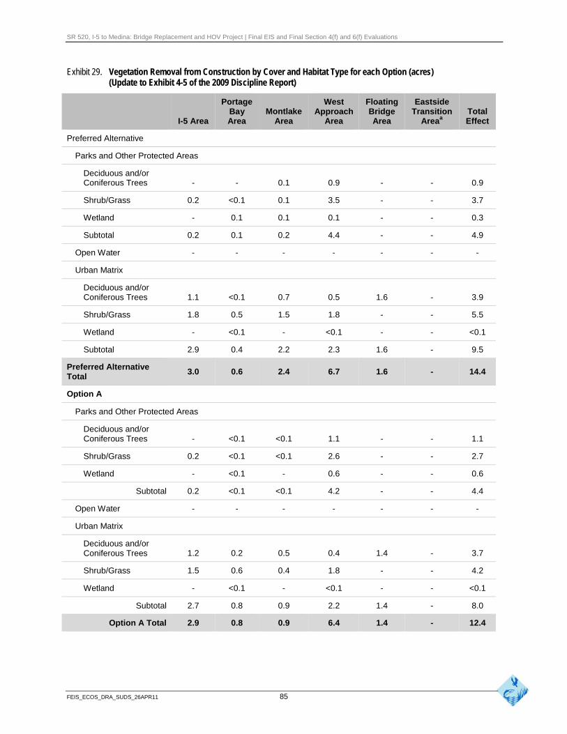
SR 520, I-5 to Medina: Bridge Replacement and HOV Project | Final EIS and Final Section 4(f) and 6(f) Evaluations
Exhibit 29. Vegetation Removal from Construction by Cover and Habitat Type for each Option (acres) (Update to Exhibit 4-5 of the 2009 Discipline Report)
Portage West Floating Eastside Bay Montlake Approach Bridge Transition Total
I-5 Area Area Area Area Area Areaa Effect
Preferred Alternative
Parks and Other Protected Areas
Deciduous and/or Coniferous Trees - - 0.1 0.9 - - 0.9
Shrub/Grass 0.2 <0.1 0.1 3.5 - - 3.7
Wetland - 0.1 0.1 0.1 - - 0.3
Subtotal 0.2 0.1 0.2 4.4 - - 4.9
Open Water - - - - - - -
Urban Matrix
Deciduous and/or Coniferous Trees 1.1 <0.1 0.7 0.5 1.6 - 3.9
Shrub/Grass 1.8 0.5 1.5 1.8 - - 5.5
Wetland - <0.1 - <0.1 - - <0.1
Subtotal 2.9 0.4 2.2 2.3 1.6 - 9.5
Preferred Alternative Total
3.0 0.6 2.4 6.7 1.6 - 14.4
Option A
Parks and Other Protected Areas
Deciduous and/or Coniferous Trees - <0.1 <0.1 1.1 - - 1.1
Shrub/Grass 0.2 <0.1 <0.1 2.6 - - 2.7
Wetland - <0.1 - 0.6 - - 0.6
Subtotal 0.2 <0.1 <0.1 4.2 - - 4.4
Open Water - - - - - - -
Urban Matrix
Deciduous and/or Coniferous Trees 1.2 0.2 0.5 0.4 1.4 - 3.7
Shrub/Grass 1.5 0.6 0.4 1.8 - - 4.2
Wetland - <0.1 - <0.1 - - <0.1
Subtotal 2.7 0.8 0.9 2.2 1.4 - 8.0
Option A Total 2.9 0.8 0.9 6.4 1.4 - 12.4
FEIS_ECOS_DRA_SUDS_26APR11 85
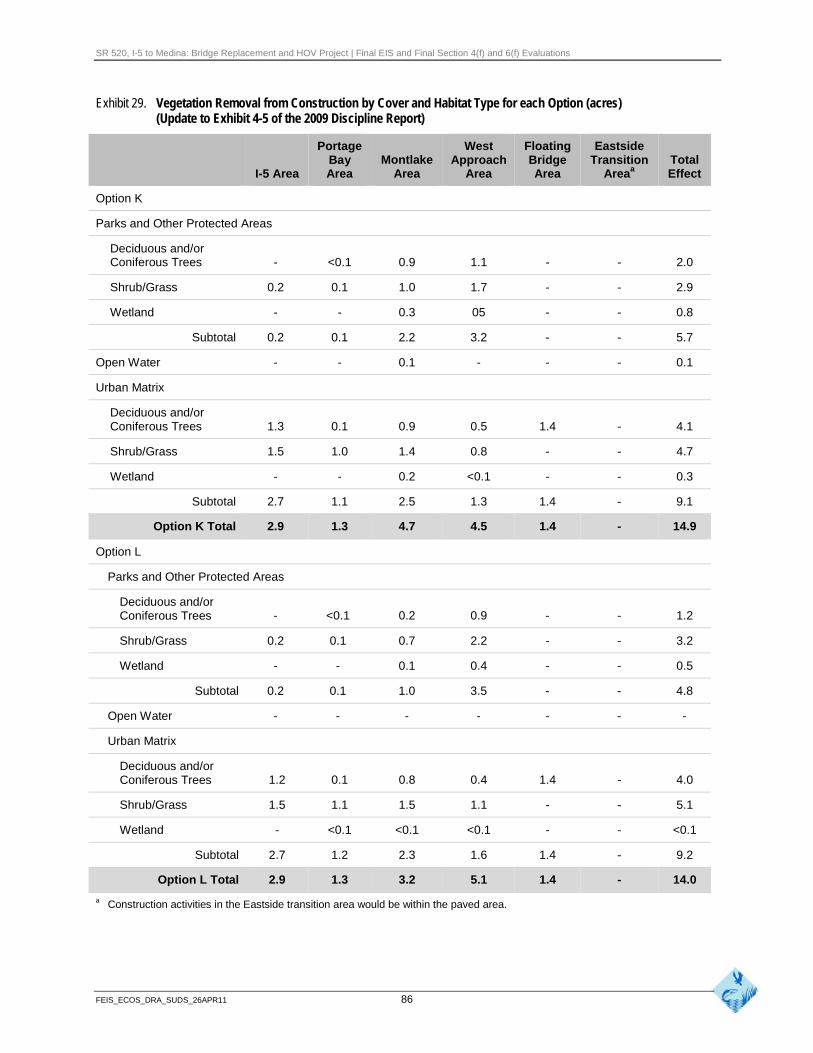
SR 520, I-5 to Medina: Bridge Replacement and HOV Project | Final EIS and Final Section 4(f) and 6(f) Evaluations
Exhibit 29. Vegetation Removal from Construction by Cover and Habitat Type for each Option (acres) (Update to Exhibit 4-5 of the 2009 Discipline Report)
Portage West Floating Eastside Bay Montlake Approach Bridge Transition Total
I-5 Area Area Area Area Area Areaa Effect
Option K
Parks and Other Protected Areas
Deciduous and/or Coniferous Trees - <0.1 0.9 1.1 - - 2.0
Shrub/Grass 0.2 0.1 1.0 1.7 - - 2.9
Wetland - - 0.3 05 - - 0.8
Subtotal 0.2 0.1 2.2 3.2 - - 5.7
Open Water - - 0.1 - - - 0.1
Urban Matrix
Deciduous and/or Coniferous Trees 1.3 0.1 0.9 0.5 1.4 - 4.1
Shrub/Grass 1.5 1.0 1.4 0.8 - - 4.7
Wetland - - 0.2 <0.1 - - 0.3
Subtotal 2.7 1.1 2.5 1.3 1.4 - 9.1
Option K Total 2.9 1.3 4.7 4.5 1.4 - 14.9
Option L
Parks and Other Protected Areas
Deciduous and/or Coniferous Trees - <0.1 0.2 0.9 - - 1.2
Shrub/Grass 0.2 0.1 0.7 2.2 - - 3.2
Wetland - - 0.1 0.4 - - 0.5
Subtotal 0.2 0.1 1.0 3.5 - - 4.8
Open Water - - - - - - -
Urban Matrix
Deciduous and/or Coniferous Trees 1.2 0.1 0.8 0.4 1.4 - 4.0
Shrub/Grass 1.5 1.1 1.5 1.1 - - 5.1
Wetland - <0.1 <0.1 <0.1 - - <0.1
Subtotal 2.7 1.2 2.3 1.6 1.4 - 9.2
Option L Total 2.9 1.3 3.2 5.1 1.4 - 14.0
a Construction activities in the Eastside transition area would be within the paved area.
FEIS_ECOS_DRA_SUDS_26APR11 86
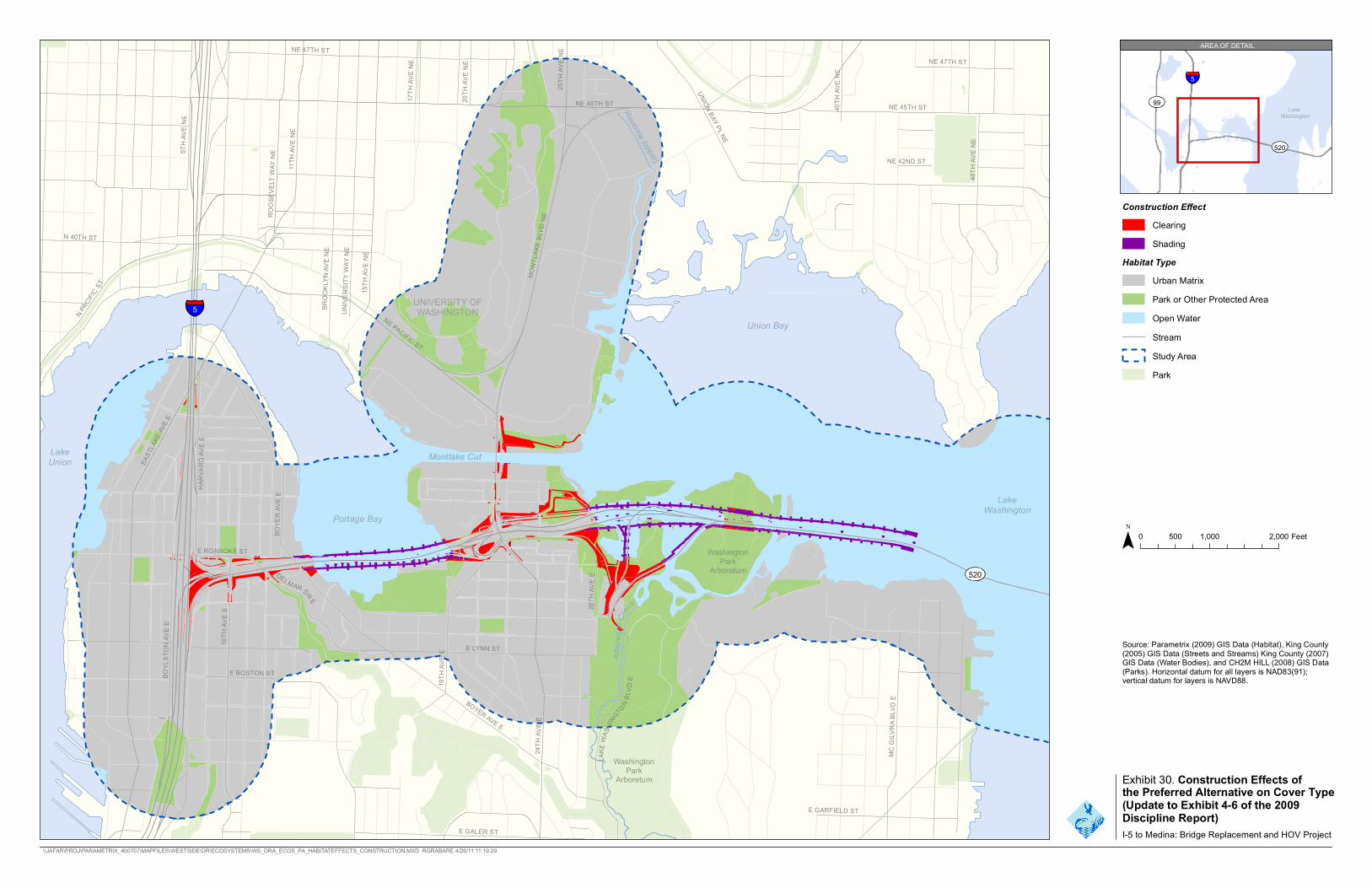
E LYNN ST
MC G
ILVRA
BLV
D E
BROO
KLYN
AVE
NE
BOYE
R AV
E E
UNIVE
RSITY
WAY
NE
48TH
AVE
NE
E GARFIELD ST
UNION BAY PL NE
NE 47TH ST
NE 45TH ST 40TH
AVE
NE
20TH
AVE
NE
17TH
AVE
NE
26TH
AVE
E
NE 47TH ST
5TH A
VE N
E
E GALER ST
10TH
AVE
E
BOYER AVE E
HARV
ARD A
VE E
DELMAR DR E
BOYL
STON
AVE E
E ROANOKE ST 24
TH AV
E E
15TH
AVE
NE
NE 45TH ST
NE PACIFIC ST
MONT
LAKE
BLV
D NE
11TH
AVE
NE
25TH
AVE
NE
ROOS
EVEL
T WAY
NE
EAST
LAKE
AVE E
E BOSTON ST
19TH
AVE
E
LAKE
WAS
HINGTON B
LVD
E
N PACIFI
C ST
N 40TH ST
Arbo
re tum
Creek
Ravenna (upper)
99
NE 42ND ST
5 UNIVERSITY OFWASHINGTON
Union Bay
LakeUnion Montlake Cut
LakeWashington
Portage Bay
WashingtPark
on Arboretum
WashingtPark
on
Arboretum
Construction Effect Clearing
Shading
Habitat TypeUrban Matrix Park or Other Protected Area Open Water Stream Study AreaPark
0 500 1,000 2,000 Feet
Source: Parametrix (2009) GIS Data (Habitat), King County(2005) GIS Data (Streets and Streams) King County (2007)GIS Data (Water Bodies), and CH2M HILL (2008) GIS Data(Parks). Horizontal datum for all layers is NAD83(91);vertical datum for layers is NAVD88.
5
LakeWashington
520
AREA OF DETAIL
Exhibit 30. Construction Effects ofthe Preferred Alternative on Cover Type(Update to Exhibit 4-6 of the 2009Discipline Report)I-5 to Medina: Bridge Replacement and HOV Project
\\JAFAR\PROJ\PARAMETRIX_400707\MAPFILES\WESTSIDE\DR\ECOSYSTEMS\WS_DRA_ECOS_PA_HABITATEFFECTS_CONSTRUCTION.MXD RGRABARE 4/26/11 11:19:29
520

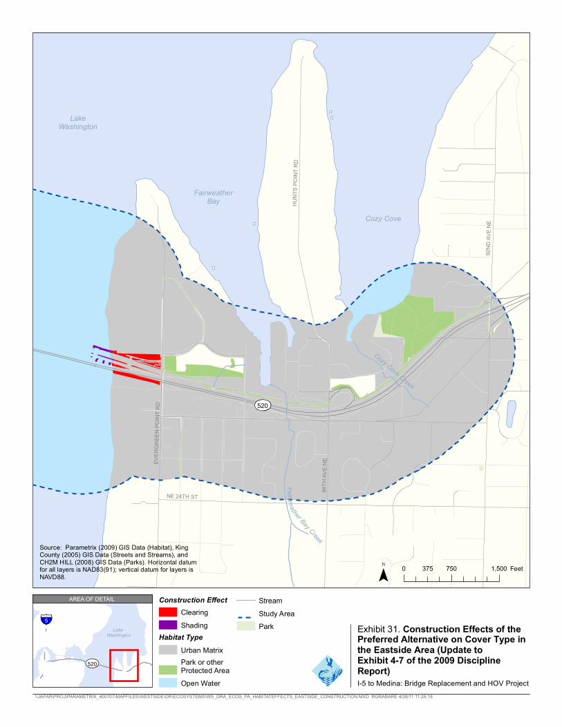
520
LakeWashington
FairweatherBay
Cozy Cove
EVER
GREE
N PO
INT R
D
NE 24TH ST
84TH
AVE N
E
HUNT
S POI
NT R
D
92ND
AVE N
E
Fa irwea ther Bay Creek
Cozy Cove Creek
Source: Parametrix (2009) GIS Data (Habitat), KingCounty (2005) GIS Data (Streets and Streams), andCH2M HILL (2008) GIS Data (Parks). Horizontal datumfor all layers is NAD83(91); vertical datum for layers is 0 375 750 1,500 FeetNAVD88.
LakeWashington
520
5
AREA OF DETAIL
I-5 to Medina: Bridge Replacement and HOV Project \\JAFAR\PROJ\PARAMETRIX_400707\MAPFILES\WESTSIDE\DR\ECOSYSTEMS\WS_DRA_ECOS_PA_HABITATEFFECTS_EASTSIDE_CONSTRUCTION.MXD RGRABARE 4/26/11 11:26:18
Construction Effect Stream Clearing Study Area
Shading Park Exhibit 31. Construction Effects of theHabitat Type Preferred Alternative on Cover Type in
Urban Matrix the Eastside Area (Update to Park or other Exhibit 4-7 of the 2009 DisciplineProtected Area Report)Open Water

SR 520, I-5 to Medina: Bridge Replacement and HOV Project | Final EIS and Final Section 4(f) and 6(f) Evaluations
Exhibit 32. Shading from Construction by Cover and Habitat Type for each Option (acres) (Update to Exhibit 4-9 of the 2009 Discipline Report)
Area, Cover Type, and Preferred Habitat Type Alternative Option A Option K Option L
Parks and Other Protected Areas
Deciduous and/or 0.7 - 0.3 0.1
Coniferous Trees
Shrub/Grass 0.2 - 0.3 <0.1
Wetland 1.3 0.8 2.1 1.2
Subtotal 2.2 0.8 2.4 1.2
Open Water (wetland) 4.7 5.2 5.6 4.7
Urban Matrix
Deciduous and/or 0.2 - <0.1 <0.1
Coniferous Trees
Shrub/Grass 0.1 - <0.1 <0.1
Wetland 0.6 0.4 0.5 0.5
Subtotal 0.9 0.4 0.6 0.5
Total 7.8 6.4 8.7 6.6
In the Lake Washington area, approximately 1.6 acres of trees in the Urban Matrix cover type would be removed along the east shoreline of Lake Washington for construction of the bridge maintenance facility and east approach (see Exhibits 29 and 31).
There would be no effects on wildlife habitat in the Eastside transition area because construction would be limited to the previously constructed and paved areas. It is assumed that the Medina to SR 202 project would be constructed prior to the SR 520, I-5 to Medina project. No vegetated wildlife habitat would be affected by the project as a result of the construction or transport of pontoons.
How would vegetation removal and shading from project construction affect City of Seattle shoreline habitat?
The shoreline of Lake Washington is protected by the City of Seattle Shoreline Master program (CSC 23.60). A portion of the overall wildlife habitat in the study area encompasses the City’s shoreline habitat. Approximately 2.6 acres of vegetation would be removed and 0.2 acre would be shaded within the shoreline habitat zone of Portage Bay and Union Bay during construction. This shoreline habitat would be disturbed for approximately 5 years and would reduce the available area for those species that use the aquatic-terrestrial shoreline habitat. Not all shoreline would be disturbed for this entire time, as construction would not be occurring in all areas for the entire construction period.
FEIS_ECOS_DRA_SUDS_26APR11 90
SR 520, I-5 to Medina: Bridge Replacement and HOV Project | Final EIS and Final Section 4(f) and 6(f) Evaluations
How would construction-related water quality effects affect wildlifeand habitat?
Construction-related water quality effects from the Preferred Alternative would be similar to those of the SDEIS options. These potential effects would be minimized by using BMPs to meet state water quality standards during construction. Refer to pages 4-36 and 4-37 in the 2009 Ecosystems Discipline Report (WSDOT 2009a) for details. In addition, effects on water quality from the Preferred Alternative are discussed in the Water Resources Discipline Report Addendum and Errata (WSDOT 2011c).
How would noise and other project construction activities affect wildlife and habitat?
The terms “construction noise” and “general construction” refer to the use of all heavy equipment, except pile-driving, during the construction of bridges, additional lanes, lids, interchanges, ramps, tunnels, and traffic turnarounds. Pile-driving is discussed separately because of the relatively high noise levels that it would produce.
Noise and other disturbances from construction activities could occur over approximately 7 years during the entire construction period for the Preferred Alternative. In general, most wildlife species found in areas adjacent to the project site are already adapted to urban conditions and highway noise. However, loud construction activities could displace some animals or discourage them from using adjacent habitats. Noise levels from construction are expected to be similar to the SDEIS options. Refer to pages 4-37 to 4-43 in the 2009 Ecosystems Discipline Report (WSDOT 2009a) for details.
The average noise levels near wildlife habitat along SR 520 (within 100 feet) would increase during general construction. Noise levels would decrease with distance from the construction area; in most cases, noise levels at distances of 750 to 1,000 feet from areas of active construction would be similar to existing noise levels. Noise from construction could cause wildlife to avoid this area during construction. See the Noise Discipline Report Addendum and Errata (WSDOT 2011d) for more details on construction noise.
Some birds, such as Canada geese and cliff swallows, have been known to build nests on the existing bridge. Construction of a new bridge and removal of existing structures could disrupt active nests of these species, which are protected under the Migratory Bird Treaty Act. To protect nesting birds from harm, WSDOT may position exclusion devices and remove nest material before the beginning of the nesting season to prevent swallows or geese from nesting on the bridge during construction.
Federally Listed Species and Federal Species of Concern
Vegetation clearing for construction work bridges of the Preferred Alternative, as well as the SDEIS options, would involve removing several large trees near the Arboretum, some of which may be suitable for bald eagle nesting. Additionally, project construction would require the removal of the two sculptures on either side of the existing Evergreen Point Bridge that bald eagles often use for
FEIS_ECOS_DRA_SUDS_26APR11 91
SR 520, I-5 to Medina: Bridge Replacement and HOV Project | Final EIS and Final Section 4(f) and 6(f) Evaluations
perching. However, most suitable bald eagle nesting and perching trees within the project vicinity would not be affected by project construction.
Noise from general construction activities could affect bald eagles, particularly the pair in the Broadmoor area. Pile-driving would generate the most noise and is expected to have the greatest potential to disturb nesting or foraging eagles. The response of individual eagles to noise disturbance would depend on the timing and intensity of the noise, the degree to which the birds are accustomed to such disturbance, and other factors.
Noise levels from construction activities are not expected to disturb the eagles currently nesting in the Broadmoor area. Management guidelines developed by the USFWS (2007) recommend that construction activities should take place at least 660 feet from active bald eagle nests. WDFW management recommendations for bald eagles discourage activities that generate loud noises within 800 feet of active bald eagle nests during the breeding season (Watson and Rodrick 2004). All three nest sites in the Broadmoor area are at least 900 feet from the pile-driving and construction work bridge areas.
Bald eagles are most sensitive to disturbance at nest sites between early February and mid-April, while the period of lowest sensitivity extends from mid-July through late January (Stinson et al. 2007). Most pile-driving would occur from September through January and is therefore not expected to affect nesting bald eagles. Noise from these activities could be audible at all three of the nest sites within the Broadmoor area when adults are establishing territories and beginning incubation. The response of the Broadmoor eagle pair to pile-driving noise cannot be predicted with certainty.
Construction noise and pile-driving may affect foraging peregrine falcons at Portage and Union bays. The birds would likely avoid portions of the bays near construction and pile-driving activities. However, other foraging habitat that the birds are known to use would remain, but overall effects on the birds are expected to be negligible.
State-listed and Other State Priority Species
Similar to the SDEIS options, noise from construction activities and pile-driving would likely temporarily displace state-listed and priority species (western grebe, common loon, great blue heron, cavity-nesting ducks, band-tailed pigeon, and pileated woodpecker). According to the Priority Habitats and Species data (WDFW 2010), none of these species is reported to nest in the Seattle portion of the study area; consequently, construction disturbance would not be likely to affect nesting success.
Lighting
Lighting associated with nighttime highway construction could also disturb wildlife. Such disturbance is expected to be greatest in areas where existing light levels are relatively low and in areas with minimal vegetation or other structures that can block the light. Wildlife would likely move away from areas of bright nighttime construction lighting.
FEIS_ECOS_DRA_SUDS_26APR11 92
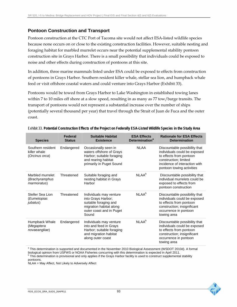
SR 520, I-5 to Medina: Bridge Replacement and HOV Project | Final EIS and Final Section 4(f) and 6(f) Evaluations
Pontoon Construction and Transport
Pontoon construction at the CTC Port of Tacoma site would not affect ESA-listed wildlife species because none occurs on or close to the existing construction facilities. However, suitable nesting and foraging habitat for marbled murrelet occurs near the potential supplemental stability pontoon construction site in Grays Harbor. There is a small possibility that individuals could be exposed to noise and other effects during construction of pontoons at this site.
In addition, three marine mammals listed under ESA could be exposed to effects from construction of pontoons in Grays Harbor. Southern resident killer whale, stellar sea lion, and humpback whale feed or visit offshore coastal waters and could venture into Grays Harbor (Exhibit 33).
Pontoons would be towed from Grays Harbor to Lake Washington in established towing lanes within 7 to 10 miles off shore at a slow speed, resulting in as many as 77 tow/barge transits. The transport of pontoons would not represent a substantial increase over the number of ships (potentially several thousand per year) that travel through the Strait of Juan de Fuca and the outer coast.
Exhibit 33. Potential Construction Effects of the Project on Federally ESA-Listed Wildlife Species in the Study Area
Federal Suitable Habitat ESA Effects Rationale for ESA Effects Species Status Existence Determinationa Determination
Southern resident killer whale (Orcinus orca)
Endangered Occasionally seen in waters offshore of Grays Harbor; suitable foraging and rearing habitat primarily in Puget Sound
NLAA Discountable possibility that individuals could be exposed to effects from pontoon construction; limited incidence of interaction with pontoon towing activities
Marbled murrelet (Brachyramphus marmoratus)
Threatened Suitable foraging and nesting habitat in Grays Harbor
NLAAb Discountable possibility that individual murrelets could be exposed to effects from pontoon construction
Steller Sea Lion (Eumetopias jubatus)
Threatened Individuals may venture into Grays Harbor; suitable foraging and migration habitat along outer coast and in Puget Sound
NLAAb Discountable possibility that individuals could be exposed to effects from pontoon construction; insignificant occurrence in pontoon towing area
Humpback Whale (Megaptera novaeangliae)
Endangered Individuals may venture into and feed in Grays Harbor; suitable foraging and migration habitat along outer coast
NLAAb Discountable possibility that individuals could be exposed to effects from pontoon construction; insignificant occurrence in pontoon towing area
a This determination is supported and documented in the November 2010 Biological Assessment (WSDOT 2010d). A formal biological opinion from USFWS or NOAA Fisheries concurring with this determination is expected in April 2011.b This determination is provisional and only applies if the Grays Harbor facility is used to construct supplemental stability pontoons. NLAA = May Affect, Not Likely to Adversely Affect
FEIS_ECOS_DRA_SUDS_26APR11 93
SR 520, I-5 to Medina: Bridge Replacement and HOV Project | Final EIS and Final Section 4(f) and 6(f) Evaluations
Several federally protected wildlife species may occur in marine waters along the pontoon transport route as described in the 2009 Ecosystems Discipline Report (WSDOT 2009a). Key habitat elements for many of these species are generally close to shore and well away from the shipping lanes where pontoon transport would occur. Some individuals may use areas farther offshore, primarily for foraging. However, pontoon towing activities are not expected to affect ESA-listed species that could occur along or within the towing routes (shipping lanes). Increased ship traffic associated with pontoon transport would not be expected to result in a noticeable increase in the amount of noise and disturbance to these species. The risk of collisions with any of these species would be negligible. All the ESA-listed birds and marine mammals can fly or swim quickly away from any oncoming vessels except leatherback sea turtles, which are slow swimmers. Given the rarity of this species in Washington waters, the likelihood of a leatherback sea turtle encounter is low.
In the unlikely event of an interaction, any disturbance would be short-term and localized, with no lasting effects. Vessel strikes of marine mammals are extremely unlikely because the barge-sized vessels are slow-moving, follow a predictable course, do not target marine mammals, and should be easily detected and avoided by marine mammals. Potential effects from vessel strikes are therefore discountable.
Pontoon transport is not likely to adversely affect southern resident killer whales or their critical habitat. The vessel traffic associated with pontoon transport is minor in comparison to overall shipping traffic in the whales’ habitat area and will not result in measureable decreases in availability of prey.
No state-listed wildlife or marine mammals are expected to occur in the pontoon construction and transport area.
How do the construction effects on wildlife and habitat compare to the SDEIS options? Both clearing and shade from construction activities are similar to the effects disclosed in the SDEIS. The Preferred Alternative has more clearing of wildlife habitat than Option A but approximately the same as Options K and L. The Preferred Alternative has more shading than Options A and L but less than Option K (see Exhibits 29 to 32). Wildlife that currently may be using this habitat would be displaced from these areas during construction. Areas cleared or shaded during construction would be revegetated at the end of the project. There would be no substantial differences between the Preferred Alternative and the SDEIS options regarding the effects of construction activities (including pontoon transport) on federally protected wildlife species.
How would operation of the project affect wildlife and habitat? The project has the potential to affect habitat and/or wildlife in the following ways:
Vegetation used by wildlife affected by removal, shading, and changes in hydrology
Water quality effects from increased stormwater treatment
Changes in obstructions to animal movement
FEIS_ECOS_DRA_SUDS_26APR11 94
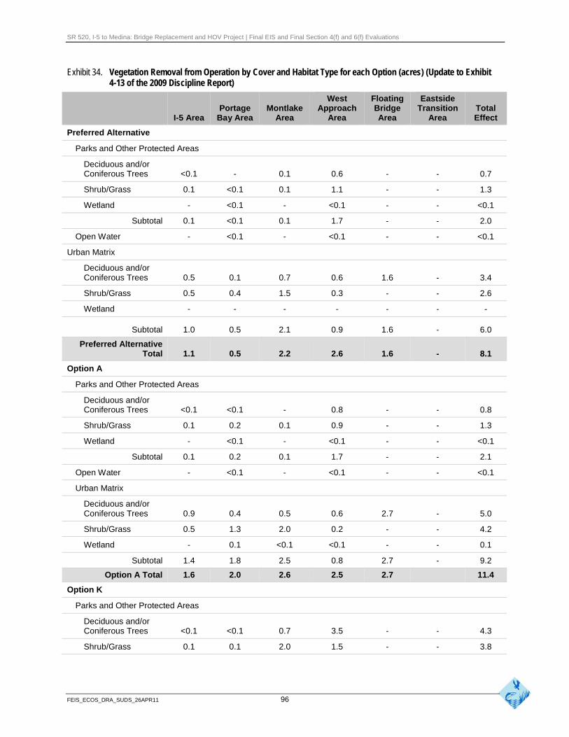
SR 520, I-5 to Medina: Bridge Replacement and HOV Project | Final EIS and Final Section 4(f) and 6(f) Evaluations
Exhibit 34. Vegetation Removal from Operation by Cover and Habitat Type for each Option (acres) (Update to Exhibit 4-13 of the 2009 Discipline Report)
West Floating Eastside Portage Montlake Approach Bridge Transition Total
I-5 Area Bay Area Area Area Area Area Effect
Preferred Alternative
Parks and Other Protected Areas
Deciduous and/or Coniferous Trees <0.1
Shrub/Grass 0.1
Wetland -
Subtotal 0.1
Open Water -
Urban Matrix
Deciduous and/or Coniferous Trees 0.5
Shrub/Grass 0.5
Wetland -
-
<0.1
<0.1
<0.1
<0.1
0.1
0.4
-
0.1
0.1
-
0.1
-
0.7
1.5
-
0.6
1.1
<0.1
1.7
<0.1
0.6
0.3
-
-
-
-
-
-
1.6
-
-
-
-
-
-
-
-
-
-
0.7
1.3
<0.1
2.0
<0.1
3.4
2.6
-
Subtotal 1.0
Preferred Alternative Total 1.1
Option A
Parks and Other Protected Areas
Deciduous and/or Coniferous Trees <0.1
Shrub/Grass 0.1
Wetland -
Subtotal 0.1
Open Water -
Urban Matrix
Deciduous and/or Coniferous Trees 0.9
Shrub/Grass 0.5
Wetland -
Subtotal 1.4
0.5
0.5
<0.1
0.2
<0.1
0.2
<0.1
0.4
1.3
0.1
1.8
2.1
2.2
-
0.1
-
0.1
-
0.5
2.0
<0.1
2.5
0.9
2.6
0.8
0.9
<0.1
1.7
<0.1
0.6
0.2
<0.1
0.8
1.6
1.6
-
-
-
-
-
2.7
-
-
2.7
-
-
-
-
-
-
-
-
-
-
-
6.0
8.1
0.8
1.3
<0.1
2.1
<0.1
5.0
4.2
0.1
9.2
Option A Total 1.6 2.0 2.6 2.5 2.7 11.4
Option K
Parks and Other Protected Areas
Deciduous and/or Coniferous Trees <0.1 <0.1 0.7 3.5 - - 4.3
Shrub/Grass 0.1 0.1 2.0 1.5 - - 3.8
FEIS_ECOS_DRA_SUDS_26APR11 96
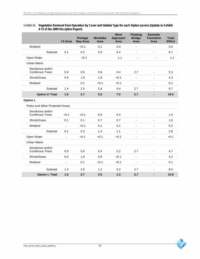
SR 520, I-5 to Medina: Bridge Replacement and HOV Project | Final EIS and Final Section 4(f) and 6(f) Evaluations
Exhibit 34. Vegetation Removal from Operation by Cover and Habitat Type for each Option (acres) (Update to Exhibit 4-13 of the 2009 Discipline Report)
West Floating Eastside Portage Montlake Approach Bridge Transition Total
I-5 Area Bay Area Area Area Area Area Effect
Wetland - <0.1 0.1 0.4 - - 0.6
Subtotal 0.1 0.2 2.9 5.4 - - 8.7
Open Water - <0.1 1.1 - - 1.1
Urban Matrix
Deciduous and/or Coniferous Trees 0.9 0.5 0.8 0.4 2.7 - 5.3
Shrub/Grass 0.5 1.9 1.8 <0.1 - - 4.3
Wetland - 0.1 <0.1 <0.1 - - 0.1
Subtotal 1.4 2.5 2.6 0.4 2.7 - 9.7
Option K Total 1.6 2.7 5.5 7.0 2.7 - 19.5
Option L
Parks and Other Protected Areas
Deciduous and/or Coniferous Trees <0.1 <0.1 0.6 0.4 - - 1.0
Shrub/Grass 0.1 0.1 0.7 0.7 - - 1.6
Wetland - <0.1 0.1 0.1 - - 0.2
Subtotal 0.1 0.2 1.4 1.1 - - 2.8
Open Water - <0.1 <0.1 <0.1 - - <0.1
Urban Matrix
Deciduous and/or Coniferous Trees 0.9 0.6 0.4 0.2 2.7 - 4.7
Shrub/Grass 0.5 1.9 0.8 <0.1 - - 3.2
Wetland - 0.1 <0.1 <0.1 - - 0.1
Subtotal 1.4 2.5 1.2 0.2 2.7 - 8.0
Option L Total 1.6 2.7 2.5 1.3 2.7 - 10.8
FEIS_ECOS_DRA_SUDS_26APR11 97

SR 520, I-5 to Medina: Bridge Replacement and HOV Project | Final EIS and Final Section 4(f) and 6(f) Evaluations
How would vegetation removal and shading from project operation affect City of Seattle shoreline habitat?
The shoreline of Lake Washington is protected by the City of Seattle Shoreline Master program (CSC 23.60). A portion of the overall wildlife habitat in the study area encompasses the City’s shoreline habitat. Of this area, approximately 1.0 acre of City of Seattle-designated shoreline habitat would be permanently removed and 0.6 acre would be permanently shaded by the Preferred Alternative.
How would changes in water quality during project operation affect wildlife and habitat?
The Preferred Alternative would include stormwater treatment facilities to treat and remove pollutants from the roadway and associated structures. Similar to the SDEIS options, sediment loads to receiving water bodies, including wetlands, would be reduced from existing conditions with the Preferred Alternative.
The Water Resources Discipline Report Addendum and Errata (WSDOT 2011c) provides updated information regarding the anticipated effects on water quality within specific basins.
How would project operation cause disturbances to wildlife?
Highway noise disturbs wildlife and can affect species distribution and behavior. Noise levels in the general area are predicted to be lower under the Preferred Alternative than existing conditions and in some locations, may be slightly higher than described for the SDEIS options. Consequently, noise disturbance to wildlife would be the same as outlined in the 2009 Ecosystems Discipline Report (pages 4-48 and 4-59) and likely slightly lower than under existing conditions. In addition, refer to the Noise Discipline Report Addendum and Errata (WSDOT 2011d) for more details regarding noise effects from the Preferred Alternative.
How would project operation result in barriers or obstructions to wildlife movement?
Throughout most of the Seattle area, the roadway would be higher above the water than the existing bridges, and would be higher through Union Bay out to the west transition span than with the SDEIS options. Effects on wildlife would be similar to the SDEIS options. Elevating the roadway (especially through the Foster Island area) could positively or negatively affect waterfowl and shorebirds, depending on their flight patterns and behavior. Refer to pages 4-60 and 4-61 in the 2009 Ecosystems Discipline Report (WSDOT 2009a) for more information.
The portion of the highway that crosses Foster Island would be adjacent to forested passerine bird habitat similar to existing conditions. However, the bridges would be elevated approximately 24 to 28 feet high above the western and eastern shorelines and could influence foraging behavior in this area.
FEIS_ECOS_DRA_SUDS_26APR11 98
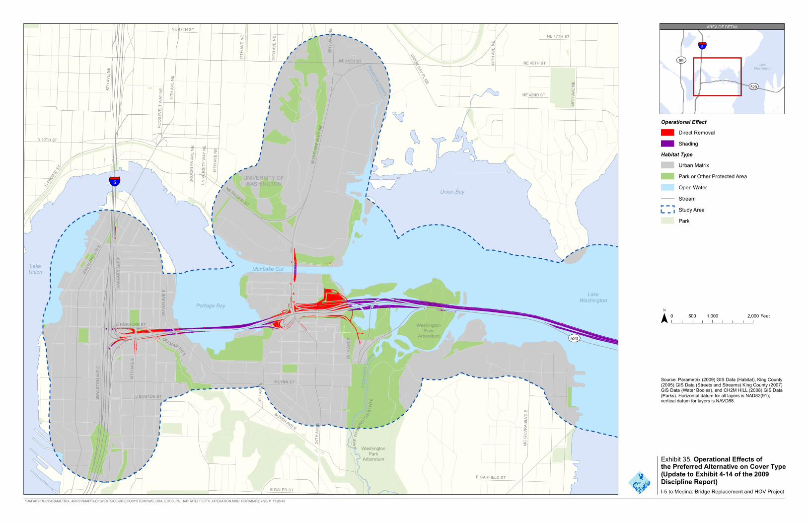
E LYNN ST
MC G
ILVRA
BLV
D E
BROO
KLYN
AVE
NE
BOYE
R AV
E E
UNIVE
RSITY
WAY
NE
48TH
AVE
NE
E GARFIELD ST
UNION BAY PL NE
NE 47TH ST
NE 45TH ST 40TH
AVE
NE
20TH
AVE
NE
17TH
AVE
NE
26TH
AVE
E
NE 47TH ST
5TH A
VE N
E
E GALER ST
10TH
AVE
E
BOYER AVE E
HARV
ARD A
VE E
DELMAR DR E
BOYL
STON
AVE E
E ROANOKE ST 24
TH AV
E E
15TH
AVE
NE
NE 45TH ST
NE PACIFIC ST
MONT
LAKE
BLV
D NE
11TH
AVE
NE
25TH
AVE
NE
ROOS
EVEL
T WAY
NE
EAST
LAKE
AVE E
E BOSTON ST
19TH
AVE
E
LAKE
WAS
HINGTON B
LVD
E
N PACIFI
C ST
N 40TH ST
Arbo
re tum
Creek
Ravenna (upper)
99
NE 42ND ST
5 UNIVERSITY OFWASHINGTON
Union Bay
LakeUnion Montlake Cut
LakeWashington
Portage Bay
WashingtPark
on Arboretum
WashingtPark
on
Arboretum
Operational Effect Direct Removal Shading
Habitat TypeUrban Matrix Park or Other Protected Area Open Water Stream Study AreaPark
0 500 1,000 2,000 Feet
Source: Parametrix (2009) GIS Data (Habitat), King County(2005) GIS Data (Streets and Streams) King County (2007)GIS Data (Water Bodies), and CH2M HILL (2008) GIS Data(Parks). Horizontal datum for all layers is NAD83(91);vertical datum for layers is NAVD88.
5
LakeWashington
520
AREA OF DETAIL
Exhibit 35. Operational Effects ofthe Preferred Alternative on Cover Type(Update to Exhibit 4-14 of the 2009Discipline Report)I-5 to Medina: Bridge Replacement and HOV Project
\\JAFAR\PROJ\PARAMETRIX_400707\MAPFILES\WESTSIDE\DR\ECOSYSTEMS\WS_DRA_ECOS_PA_HABITATEFFECTS_OPERATION.MXD RGRABARE 4/26/11 11:28:48
520


520
LakeWashington
FairweatherBay
Cozy Cove
EVER
GREE
N PO
INT R
D
NE 24TH ST
84TH
AVE N
E
HUNT
S POI
NT R
D
92ND
AVE N
E
Fa irwea ther Bay Creek
Cozy Cove Creek
Source: Parametrix (2009) GIS Data (Habitat), KingCounty (2005) GIS Data (Streets and Streams), andCH2M HILL (2008) GIS Data (Parks). Horizontal datumfor all layers is NAD83(91); vertical datum for layers is 0 375 750 1,500 FeetNAVD88.
LakeWashington
520
5
AREA OF DETAIL
I-5 to Medina: Bridge Replacement and HOV Project \\JAFAR\PROJ\PARAMETRIX_400707\MAPFILES\WESTSIDE\DR\ECOSYSTEMS\WS_DRA_ECOS_PA_HABITATEFFECTS_EASTSIDE_OPERATION.MXD RGRABARE 4/26/11 11:27:34
Operational Effect Stream Direct Removal Study Area
Shading Park Exhibit 36. Operational Effects of theHabitat Type Preferred Alternative on Cover Type in
Urban Matrix the Eastside Area (Update to Park or other Exhibit 4-15 of the 2009 DisciplineProtected Area Report)Open Water
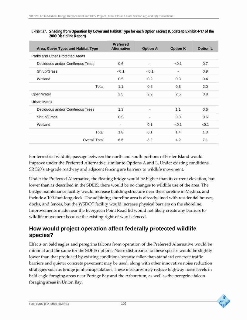
SR 520, I-5 to Medina: Bridge Replacement and HOV Project | Final EIS and Final Section 4(f) and 6(f) Evaluations
Exhibit 37. Shading from Operation by Cover and Habitat Type for each Option (acres) (Update to Exhibit 4-17 of the 2009 Discipline Report)
Preferred Area, Cover Type, and Habitat Type Alternative Option A Option K Option L
Parks and Other Protected Areas
Deciduous and/or Coniferous Trees 0.6 - <0.1 0.7
Shrub/Grass <0.1 <0.1 - 0.9
Wetland 0.5 0.2 0.3 0.4
Total 1.1 0.2 0.3 2.0
Open Water 3.5 2.9 2.5 3.8
Urban Matrix
Deciduous and/or Coniferous Trees 1.3 - 1.1 0.6
Shrub/Grass 0.5 - 0.3 0.6
Wetland - 0.1 <0.1 <0.1
Total 1.8 0.1 1.4 1.3
Overall Total 6.5 3.2 4.2 7.1
For terrestrial wildlife, passage between the north and south portions of Foster Island would improve under the Preferred Alternative, similar to Options A and L. Under existing conditions, SR 520’s at-grade roadway and adjacent fencing are barriers to wildlife movement.
Under the Preferred Alternative, the floating bridge would be higher than its current elevation, but lower than as described in the SDEIS; there would be no changes to wildlife use of the area. The bridge maintenance facility would increase building structure near the shoreline in Medina, and include a 100-foot-long dock. The adjoining shoreline area is already lined with residential houses, docks, and fences, but the WSDOT facility would increase physical barriers on the shoreline. Improvements made near the Evergreen Point Road lid would not likely create any barriers to wildlife movement because the existing right-of-way is fenced.
How would project operation affect federally protected wildlife species?
Effects on bald eagles and peregrine falcons from operation of the Preferred Alternative would be minimal and the same for the SDEIS options. Noise disturbance to these species would be slightly lower than that produced by existing conditions because taller-than-standard concrete traffic barriers and quieter concrete pavement may be used, along with other innovative noise reduction strategies such as bridge joint encapsulation. These measures may reduce highway noise levels in bald eagle foraging areas near Portage Bay and the Arboretum, as well as the peregrine falcon foraging areas in Union Bay.
FEIS_ECOS_DRA_SUDS_26APR11 102
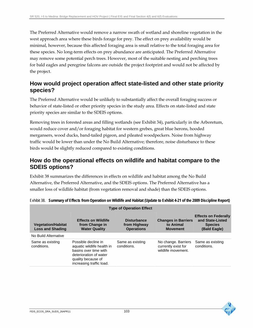
SR 520, I-5 to Medina: Bridge Replacement and HOV Project | Final EIS and Final Section 4(f) and 6(f) Evaluations
The Preferred Alternative would remove a narrow swath of wetland and shoreline vegetation in the west approach area where these birds forage for prey. The effect on prey availability would be minimal, however, because this affected foraging area is small relative to the total foraging area for these species. No long-term effects on prey abundance are anticipated. The Preferred Alternative may remove some potential perch trees. However, most of the suitable nesting and perching trees for bald eagles and peregrine falcons are outside the project footprint and would not be affected by the project.
How would project operation affect state-listed and other state priority species?
The Preferred Alternative would be unlikely to substantially affect the overall foraging success or behavior of state-listed or other priority species in the study area. Effects on state-listed and state priority species are similar to the SDEIS options.
Removing trees in forested areas and filling wetlands (see Exhibit 34), particularly in the Arboretum, would reduce cover and/or foraging habitat for western grebes, great blue herons, hooded mergansers, wood ducks, band-tailed pigeon, and pileated woodpeckers. Noise from highway traffic would be lower than under the No Build Alternative; therefore, noise disturbance to these birds would be slightly reduced compared to existing conditions.
How do the operational effects on wildlife and habitat compare to the SDEIS options?
Exhibit 38 summarizes the differences in effects on wildlife and habitat among the No Build Alternative, the Preferred Alternative, and the SDEIS options. The Preferred Alternative has a smaller loss of wildlife habitat (from vegetation removal and shade) than the SDEIS options.
Exhibit 38. Summary of Effects from Operation on Wildlife and Habitat (Update to Exhibit 4-21 of the 2009 Discipline Report)
Type of Operation Effect
Vegetation/Habitat Loss and Shading
Effects on Wildlife from Change in Water Quality
Disturbance from Highway
Operations
Changes in Barriers to Animal Movement
Effects on Federally and State-Listed
Species (Bald Eagle)
No Build Alternative
Same as existing conditions.
Possible decline in aquatic wildlife health in basins over time with
Same as existing conditions.
No change. Barriers currently exist for wildlife movement.
Same as existing conditions.
deterioration of water quality because of increasing traffic load.
FEIS_ECOS_DRA_SUDS_26APR11 103
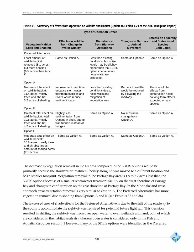
SR 520, I-5 to Medina: Bridge Replacement and HOV Project | Final EIS and Final Section 4(f) and 6(f) Evaluations
Exhibit 38. Summary of Effects from Operation on Wildlife and Habitat (Update to Exhibit 4-21 of the 2009 Discipline Report)
Type of Operation Effect
Effects on Federally
Vegetation/Habitat Loss and Shading
Effects on Wildlife from Change in Water Quality
Disturbance from Highway
Operations
Changes in Barriers to Animal Movement
and State-Listed Species
(Bald Eagle)
Preferred Alternative
Least amount of wildlife habitat removed (8.1 acres), but more shading (6.5 acres) than A or K.
Same as Option A. Less than existing conditions, but noise levels may be slightly higher than the SDEIS options because no noise walls are proposed.
Same as Option A. Same as Option A.
Option A
Moderate total effect on wildlife habitat: 11.4 acres, mostly trees and shrubs; 3.2 acres of shading.
Improvement over time because stormwater treatment facilities and BMPs would reduce sediment loads.
Less than existing conditions due to noise walls and mitigation of vegetation loss.
Barriers to wildlife would be reduced by elevating the roadway.
There would be effects from construction noise; no long-term effects expected on any species.
Option K
Greatest total effect on Slightly less Same as Option A. No substantial Same as Option A. wildlife habitat: total sedimentation from change from 19.5 acres, mostly Options A and L due to Option A. trees and shrubs; twin tunnels instead of 4.2 acres of shading. bridges.
Option L
Moderate total effect on Same as Option A. Same as Option A. Same as Option A. Same as Option A. wildlife habitat: 10.8 acres, mostly trees and shrubs; largest amount of shaded acres (7.1 acres).
The decrease in vegetation removal in the I-5 area compared to the SDEIS options would be primarily because the stormwater treatment facility along I-5 was moved to a different location and has a smaller footprint. Vegetation removal in the Portage Bay area is 1.5 to 2.2 acres less than the SDEIS options because of a smaller stormwater treatment facility on the west shoreline of Portage Bay and changes in configuration on the east shoreline of Portage Bay. In the Montlake and west approach areas vegetation removal is very similar to Option A. The Preferred Alternative has more vegetation removal due to shading than Options A and K (see Exhibits 32 and 36).
The increased area of shade effects for the Preferred Alternative is due to the shift of the roadway to the south to accommodate the right-of-way required for potential future light rail. This decision resulted in shifting the right-of-way from over open water to over wetlands and land, both of which are considered in the habitat analysis (whereas open water is considered only in the Fish and Aquatic Resources section). However, if any of the SDEIS options were identified as the Preferred
FEIS_ECOS_DRA_SUDS_26APR11 104
SR 520, I-5 to Medina: Bridge Replacement and HOV Project | Final EIS and Final Section 4(f) and 6(f) Evaluations
Alternative, design refinements to better accommodate light rail for those designs would likely also result in a similar increased effect.
Mitigation
What has been done to avoid or minimize negative effects on wildlife and habitat?
WSDOT has worked with regulatory agencies, the University of Washington, and the Muckleshoot Indian Tribe through the NRTWG to determine appropriate mitigation measures. WSDOT would use the following measures to avoid or minimize effects on wildlife and habitat:
Limit construction clearing to minimal area needed
Follow BMPs and other safety measures to minimize erosion and sedimentation and to minimize the risk of spilling contaminants
Minimize pile-driving near the Broadmoor eagle nest site during the early part of the bald eagle nesting season when the birds are most sensitive to disturbance
Avoid or minimize effects on the beaver lodge near Foster Island during construction, if possible, but its proximity to the proposed bridge columns and construction piles may preclude its avoidance
Minimize effects of towing pontoons using approved navigation channels
What would be done to mitigate negative effects that could not be avoided or minimized?
Construction Mitigation
Replant affected areas with native vegetation.
Plant native shade-tolerant vegetation in areas under the elevated roadway and ramps, where feasible and practical.
Position exclusion devices before the beginning of the nesting season to prevent swallows and Canada geese from nesting on portions of the bridge that would be under construction. These devices would remain in place in construction areas and would be monitored for effectiveness during the nesting season.
Operation Mitigation
WSDOT has coordinated with the City of Seattle and the Arboretum in developing a planting strategy to offset operation effects on regulated shoreline habitat. Many shoreline areas of Union Bay
FEIS_ECOS_DRA_SUDS_26APR11 105
SR 520, I-5 to Medina: Bridge Replacement and HOV Project | Final EIS and Final Section 4(f) and 6(f) Evaluations
and the Montlake Playfield are not fully vegetated and/or contain invasive species. Some of these areas could be replanted with native trees and shrubs and the invasive species removed.
What negative effects would remain after mitigation?
The project will re-establish approximately 9.6 acres of wetlands that will also be wildlife habitat. An additional 24.5 acres of wetland and 30.0 acres of upland buffer habitat will be enhanced within the wetland mitigation areas for the project. This mitigation would increase the overall wildlife habitat functions in the area. See Section 5 of the Conceptual Wetland Mitigation Report (Attachment 9) for additional details.
References Arhonditsis, G.B., M.T. Brett, C.L. DeGasperi, and D.E. Schindler. 2004. Effects of climatic variability on the thermal properties of Lake Washington. Limnology and Oceanography 49:256-270.
Celedonia, M.T., R.A. Tabor, S. Sanders, S. Damm, D.W. Lantz, T.M. Lee, Z. Li, J. Pratt, B.E. Price, and L. Seyda. 2008a. Movement and Habitat Use of Chinook Salmon Smolts, Northern Pikeminnow, and Smallmouth Bass near the SR 520 Bridge: 2007 Acoustic Tracking Study. U.S. Fish and Wildlife Service, Western Washington Fish and Wildlife Office, Lacey, WA.
Celedonia, M.T., R.A. Tabor, S. Sanders, D.W. Lantz, and I. Grettenberger. 2008b. Movement and Habitat Use of Juvenile Chinook Salmon and Two Predatory Fishes in Lake Washington and the Lake Washington Ship Canal: 2004–05 Acoustic Tracking Studies. U.S. Fish and Wildlife Service, Western Washington Fish and Wildlife Office, Lacey, WA.
Celedonia, M.T., R.A. Tabor, S. Sanders, S. Damm, D.W. Lantz, T.M. Lee, Z. Li, B.E. Price, W. Gale, and K. Ostrand. 2009. Unpublished Draft Report—Movement and Habitat Use of Chinook Salmon Smolts, Northern Pikeminnow, and Smallmouth Bass near the SR 520 Bridge: 2008 Acoustic Tracking Study. U.S. Fish and Wildlife Service, Western Washington Fish and Wildlife Office, Lacey, WA.
Ecology, USACE Seattle District, and USEPA Region 10. 2006. Wetland Mitigation in Washington State: Part 1: Agency Policies and Guidance. Washington State Department of Ecology Publication #06-06-011a. Olympia, WA.
Edmondson, W.T. 1994. Sixty Years of Lake Washington: a Curriculum Vitae. Lake and Reservoir Management 10:75–84.
Eggers, D.M. 1978. Limnetic Feeding Behavior of Juvenile Sockeye Salmon in Lake Washington and Predator Avoidance. Limnology and Oceanography. 23: 1114-1125.
Fisheries Hydroacoustic Working Group (FHWG). 2008. Memorandum: Agreement in Principle for Interim Criteria for Injury to Fish from Pile Driving Activities. http://www.wsdot.wa.gov/NR/rdonlyres/4019ED62-B403-489C-AF055F4713D663C9/0/BA_InterimCriteriaAgree.pdf. June 2008.
FEIS_ECOS_DRA_SUDS_26APR11 106
SR 520, I-5 to Medina: Bridge Replacement and HOV Project | Final EIS and Final Section 4(f) and 6(f) Evaluations
Fresh, K.L., E. Warner, R. Tabor, and D. Houck. 1999. Migratory Behavior of Adult Chinook Salmon Spawning in the Lake Washington Watershed in 1998 as Determined with Ultrasonic Telemetry. Progress report, National Marine Fisheries Service, Seattle, WA.
Fresh, K.L., E. Warner, R. Tabor, and D. Houck. 2000. Migratory Behavior of Adult Chinook Salmon Spawning in the Lake Washington Watershed in 1998 and 1999 as Determined by Ultrasonic Telemetry. Unpublished report. http://dnr.metrokc.gov/wtd/fish/.
Hruby, T. 2004. Washington State Wetland Rating System for Western Washington—Revised. Washington State Department of Ecology Publication # 04-06-025. Olympia, WA.
King County. 2010. King County major lakes monitoring data. http://green.kingcounty.gov/lakes/Map.aspx. Seattle, WA. Accessed September 20, 2010.
Koehler, M.E., K.L. Fresh, D.A. Beauchamp, J.R. Cordell, C.A. Simenstad, and D.E. Seiler. 2006. Diet and Bioenergetics of Lake-rearing Juvenile Chinook Salmon in Lake Washington. Transactions of the American Fisheries Society 135:1580–1591.
Newell, J.C., and T.P. Quinn. 2005. Behavioral thermoregulation by maturing adult sockeye salmon (Oncorhynchus nerka) in a stratified lake prior to spawning. Canadian Journal of Zoology 83: 1232-1239.
Schock, K.A. 2008. An Analysis of a Persistent Isotherm Tilt during Early-Spring and its Effect on the Diatom Bloom: Lake Washington, Seattle, WA. Dissertation, University of Washington, Seattle, WA. 163 p. + appendices. http://green.kingcounty.gov/lakes/reports/Isotherm-tilt-lake-washingtonreport.aspx.
Stinson, D.W., J.W. Watson, and Kelly R. McAllister. 2007. Washington State Status Report for the Bald Eagle. Washington Department of Fish and Wildlife, Olympia, WA.
U.S. Army Corps of Engineers (USACE) and City of Seattle. 2008. Synthesis of Salmon Research and Monitoring, Investigations Conducted in the Western Lake Washington Basin. December 31, 2008. Seattle, WA.
U.S. Fish and Wildlife Service (USFWS). 2007. National Bald Eagle Management Guidelines. United States Fish and Wildlife Service, Washington, D.C.
Watson, J.W. and E.A. Rodrick. 2004. Bald Eagle. Pages 9-1 through 9-15 in: E. Larsen, J.M. Azerrad, N. Nordstrom, editors. Management Recommendations for Washington’s Priority Species, Volume IV: Birds. Washington Department of Fish and Wildlife, Olympia, WA.
Washington Department of Fish and Wildlife (WDFW). 2010. Priority Habitats and Species Data. Olympia, WA.
Washington State Department of Transportation (WSDOT). 2008. Highway Runoff Manual. Publication M31-16. June 2008.
FEIS_ECOS_DRA_SUDS_26APR11 107

SR 520, I-5 to Medina: Bridge Replacement and HOV Project | Final EIS and Final Section 4(f) and 6(f) Evaluations
WSDOT. 2009a. Ecosystems Discipline Report. SR 520, I-5 to Medina Bridge: Replacement and HOV
Project. Supplemental Draft Environmental Impact Statement and Section 4(f)/6(f) Evaluation. SR 520 Bridge Replacement and HOV Program. WSDOT, Olympia, WA. December 2009.
WSDOT. 2009b. Final Wetland Vegetation Response to Shade Special Study Technical Memorandum. SR 520, I-5 to Medina: Bridge Replacement and HOV Project. Prepared for WSDOT, Olympia, WA.
WSDOT. 2009c. Hazardous Materials Discipline Report. SR 520, I-5 to Medina: Bridge Replacement and
HOV Project. Supplemental Draft Environmental Impact Statement and Section 4(f)/6(f) Evaluation. SR 520 Bridge Replacement and HOV Program. WSDOT, Olympia, WA. December 2009.
WSDOT. 2009d. WSDOT Fish Exclusion Protocols and Standards. http: //www.wsdot.wa.gov/NR/rdonlyres/6832EEA1-9B77-42C3-9F68BE28C561B298/0/BA_FishHandling.pdf.
WSDOT. 2009e. Limnological Processes White Paper. I-5 to Medina: Bridge Replacement and HOV
Project, SR 520 Bridge Replacement and HOV Program. WSDOT, Olympia, WA.
WSDOT. 2009f. Initial Wetland Mitigation Report. I-5 to Medina: Bridge Replacement and HOV
Project, SR 520 Bridge Replacement and HOV Program. WSDOT, Olympia, WA. October 2009.
WSDOT. 2009g. Initial Aquatic Mitigation Report. I-5 to Medina: Bridge Replacement and HOV
Project, SR 520 Bridge Replacement and HOV Program. WSDOT, Olympia, WA. October 2009.
WSDOT. 2010a. SR 520, Pontoon Construction Project Final Environmental Impact Statement. SR 520 Bridge Replacement and HOV Program. WSDOT, Olympia, WA. December 2010.
WSDOT. 2010b. SR 520, I-5 to Medina: Bridge Replacement and HOV Project Supplemental Draft Environmental Impact Statement and Section 4(f)/6(f) Evaluation. SR 520 Bridge Replacement and HOV Program. WSDOT, Olympia, WA. January 2010.
WSDOT. 2010c. Underwater Sound Levels Associated with Driving Steel Piles for the State Route 520 Bridge Replacement and HOV Project Pile Installation Test Program. http://www.wsdot.wa.gov/NR/rdonlyres/E12A70C2-7A11-4F83-A37B6C1D4F22694B/0/SR520PileHydroacousticRpt.pdf. Prepared by Illingworth & Rodkin, Inc. for Washington State Department of Transportation, SR 520 Bridge Replacement and HOV Project, Seattle, WA. March 2010.
WSDOT. 2010d. Biological Assessment, SR 520, I-5 to Medina: Bridge Replacement and HOV Project. November 2010.
WSDOT. 2011a. Description of Alternatives Discipline Report Addendum. SR 520, I-5 to Medina: Bridge Replacement and HOV Project. WSDOT, Olympia, WA.
WSDOT. 2011b. Construction Techniques and Activities Discipline Report Addendum and Errata. SR 520, I-5 to Medina: Bridge Replacement and HOV Project. WSDOT, Olympia, WA.
FEIS_ECOS_DRA_SUDS_26APR11 108
SR 520, I-5 to Medina: Bridge Replacement and HOV Project | Final EIS and Final Section 4(f) and 6(f) Evaluations
WSDOT. 2011c. Water Resources Discipline Report Addendum and Errata. SR 520, I-5 to Medina: Bridge Replacement and HOV Project. WSDOT, Olympia, WA.
WSDOT. 2011d. Noise Discipline Report Addendum and Errata. SR 520, I-5 to Medina: Bridge Replacement and HOV Project. WSDOT, Olympia, WA.
WSDOT. 2011e. Conceptual Wetland Mitigation Report. SR 520, I-5 to Medina: Bridge Replacement and
HOV Project. WSDOT, Olympia, WA. April 2011.
WSDOT. 2011f. Conceptual Aquatic Mitigation Plan. SR 520, I-5 to Medina: Bridge Replacement and HOV Project. WSDOT, Olympia, WA. April 2011.
WSDOT. 2011g. Geology and Soils Discipline Report Addendum and Errata. SR 520, I-5 to Medina: Bridge
Replacement and HOV Project. WSDOT, Olympia, WA.
FEIS_ECOS_DRA_SUDS_26APR11 109


Attachment 1
Errata

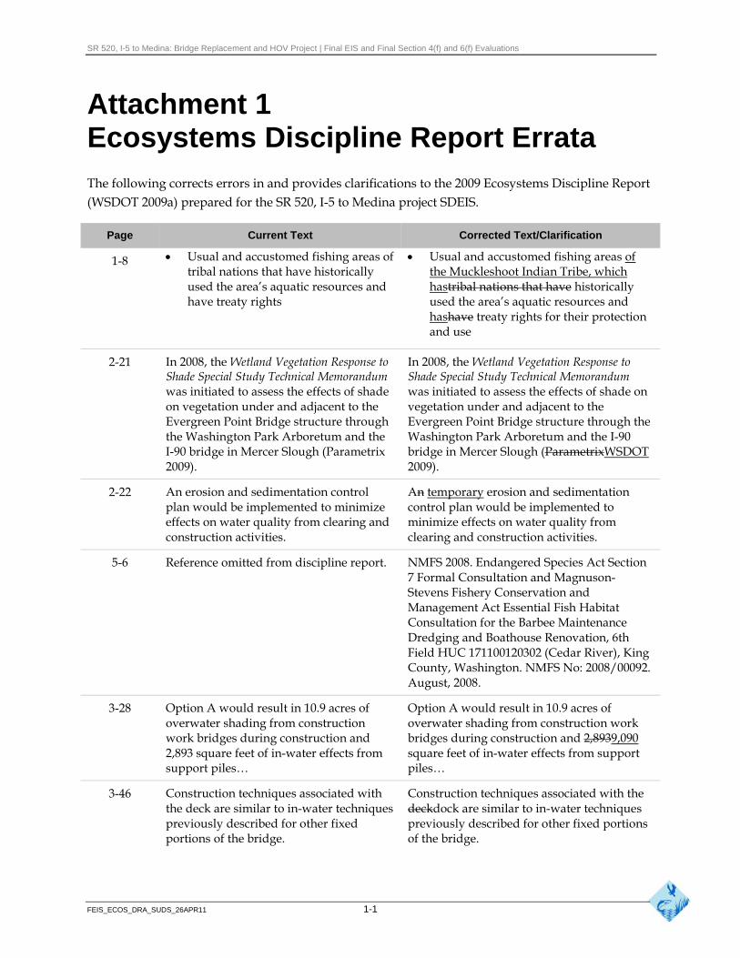
SR 520, I-5 to Medina: Bridge Replacement and HOV Project | Final EIS and Final Section 4(f) and 6(f) Evaluations
Attachment 1 Ecosystems Discipline Report Errata The following corrects errors in and provides clarifications to the 2009 Ecosystems Discipline Report (WSDOT 2009a) prepared for the SR 520, I-5 to Medina project SDEIS.
Page Current Text Corrected Text/Clarification
1-8 Usual and accustomed fishing areas of tribal nations that have historically used the area’s aquatic resources and have treaty rights
Usual and accustomed fishing areas of the Muckleshoot Indian Tribe, which hastribal nations that have historically used the area’s aquatic resources and hashave treaty rights for their protection and use
2-21
2-22
In 2008, the Wetland Vegetation Response to Shade Special Study Technical Memorandum was initiated to assess the effects of shade on vegetation under and adjacent to the Evergreen Point Bridge structure through the Washington Park Arboretum and the I-90 bridge in Mercer Slough (Parametrix 2009).
An erosion and sedimentation control plan would be implemented to minimize effects on water quality from clearing and construction activities.
In 2008, the Wetland Vegetation Response to Shade Special Study Technical Memorandum was initiated to assess the effects of shade on vegetation under and adjacent to the Evergreen Point Bridge structure through the Washington Park Arboretum and the I-90 bridge in Mercer Slough (ParametrixWSDOT 2009).
An temporary erosion and sedimentation control plan would be implemented to minimize effects on water quality from clearing and construction activities.
5-6 Reference omitted from discipline report. NMFS 2008. Endangered Species Act Section 7 Formal Consultation and Magnuson-Stevens Fishery Conservation and Management Act Essential Fish Habitat Consultation for the Barbee Maintenance Dredging and Boathouse Renovation, 6th Field HUC 171100120302 (Cedar River), King County, Washington. NMFS No: 2008/00092. August, 2008.
3-28 Option A would result in 10.9 acres of overwater shading from construction work bridges during construction and 2,893 square feet of in-water effects from support piles…
Option A would result in 10.9 acres of overwater shading from construction work bridges during construction and 2,8939,090 square feet of in-water effects from support piles…
3-46 Construction techniques associated with the deck are similar to in-water techniques previously described for other fixed portions of the bridge.
Construction techniques associated with the deckdock are similar to in-water techniques previously described for other fixed portions of the bridge.
FEIS_ECOS_DRA_SUDS_26APR11 1-1
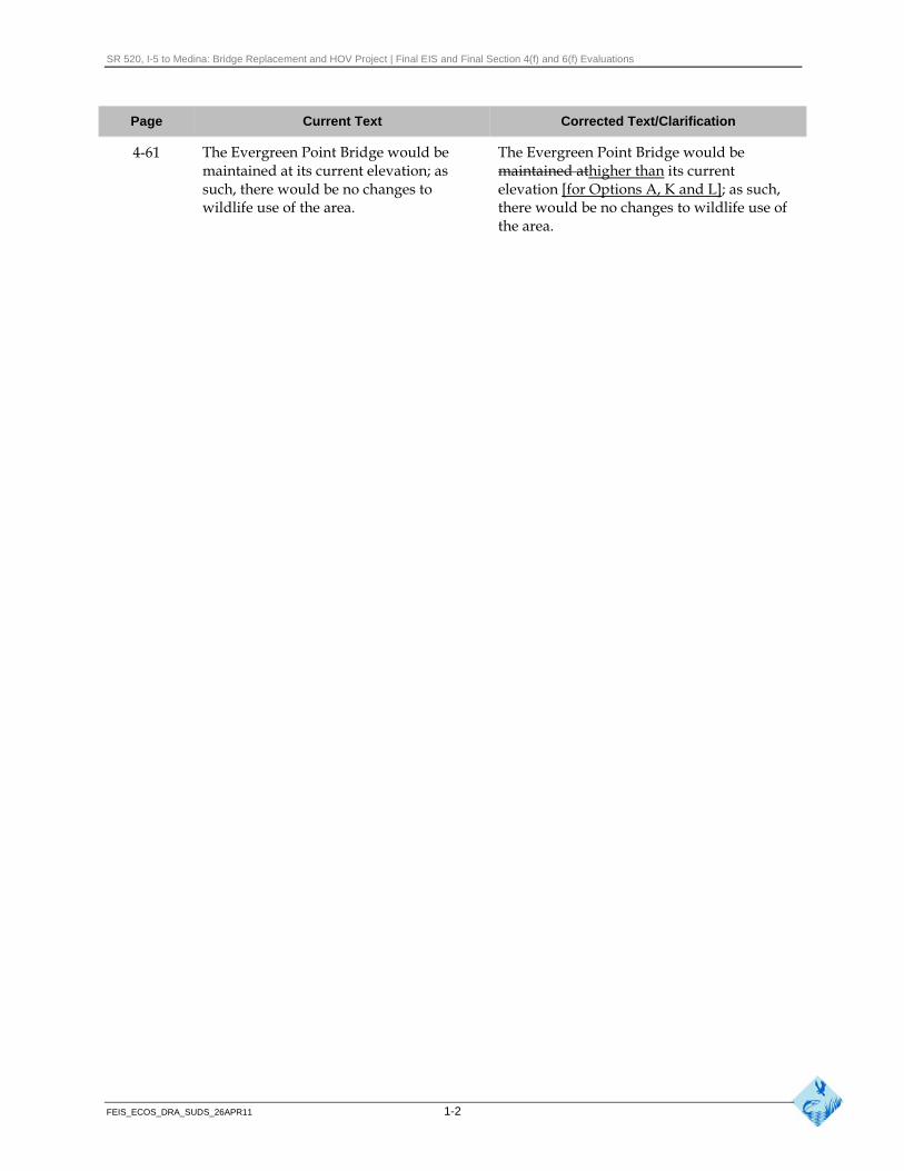
SR 520, I-5 to Medina: Bridge Replacement and HOV Project | Final EIS and Final Section 4(f) and 6(f) Evaluations
Page Current Text Corrected Text/Clarification
4-61 The Evergreen Point Bridge would be maintained at its current elevation; as such, there would be no changes to wildlife use of the area.
The Evergreen Point Bridge would be maintained athigher than its current elevation [for Options A, K and L]; as such, there would be no changes to wildlife use of the area.
FEIS_ECOS_DRA_SUDS_26APR11 1-2


![ICF-M770L/M770S/M770SL - Kazenice.kaze.com/sony_icf-m770sl_svm.pdf · ICF-M770L/M770S/M770SL no mark: common (): ICF-M770L []: ICF-M770S 〈〈 〉〉: ICF-M770SL AM IF ADJUSTMENT](https://img.pdfslide.us/doc/110x75/5f05960a7e708231d413b21e/icf-m770lm770sm770sl-icf-m770lm770sm770sl-no-mark-common-icf-m770l-.jpg)