Embed Size (px)
Citation preview
1
MAB-UNESCO Dení Rayn PhD
Status Report
Ecosystem integrity and community participation related to water
availability within and around Calakmul Biosphere Reserve
Prepared by Dení Rayn PhD1
2009
1Contact details: [email protected]
2
Front cover photo: Panoramic view of Calakmul Biosphere Reserve from Structure II in Calakmul archeological
site (by Dení Rayn)
Table of contents
Abstract.................................................................................................................. .3
Intro………………………………………………………………………………..4
Study site…………………………………………………………………………..5
Vegetation…………………………………………………………………………7
Fauna………………………………………………………………………………10
Waterholes………………………………………………………………………...11
Socio-demographic and economic profile………………………………………12
Objectives………………………………………………………………………….13
Methods……………………………………………………………………………13
Results....…………………………………………………………………………...14
Conclusions and recommendations......................................................................35
Future work.............................................................................................................37
References…………………………………………………………………………38
Annexes……………………………………………………………………………39

3
ABSTRACT
Calakmul Region is part of the second largest area of tropical forests in North America, the
Maya Forest. It was decreed as a reserve in 1989 . In 1993 the reserve was included in the
international web of the programme "Man the Biosphere" of UNESCO. In Calakmul
permanent water holes tend to be located in bigger numbers surrounding settlements (ejidos).
As a result, individuals of species such as Tapir, White-lipped Peccary and Jaguar, must go
outside the limits of the reserve to get water. We collected data already available from the
reserve and academic institutions in order to be integrated; we monitored selected water holes
within and adjacent to Calakmul Biosphere Reserve and visited adjacent ejidos to interview
local people and to explore the possibility of community participation in proposals such as
voluntary reserves. In all communities visited favorable conditions were found for the
implementation of internal regulations that would allow to protect waterholes and fauna
within the ejidos.

4
Introduction
Due to the karstic nature of Yucatan´s peninsula, the soil gets saturated with water during
rain season forming water holes or “aguadas” in the lower regions. During dry season these
water holes are the main source of water to fauna (Aranda, 1990, Aranda,1994, Hernández-
Huerta et al 2000, Naranjo, 2001; García_Gil 2003). Permanent water holes tend to be
located in bigger numbers surrounding settlements (ejidos) (S. Calmé, pers. com). As a
result, individuals of species such as Tapir, White-lipped Peccary and Jaguar, must go
outside the limits of the reserve to get water (March 1994, Hernández-Huerta et al 2000,
Escalona-Segura et al 2002, García –Escalona 2003, García-Gil 2003, Martínez-Kú
2007).There are some studies on the relation between water holes and fauna (García-
Escalona, 2003; Mandujano and Gallina, 1995; Vaughan y Weiss, 1999, Martínez-Kú 2007).
Martínez_Kú (2007) data sustains that areas with water holes have more diversity of mid-size
mammals during dry season while there is no significant difference during rainy season. He
also reports that human activities in the waterhole area can have an impact on the habitat.
However, more information is necessary to understand how this works.
When planning the reserve’s boundaries, the location of villages and land use by local
inhabitants were not taken into account, in particular because the region was barely being
settled at the time the reserve was decreed (1989). Since then, the population grew from 3,000
to more than 25,000 people. The location of areas of special importance for biodiversity
conservation was not considered either. The poor design of the core areas (Galindo-Leal
1999) has resulted in the southern core area being located adjacent to several villages without
any buffer zone in between and as a consequence, it is very vulnerable to slash and burn
agriculture, as well as poaching and wildlife trafficking.
Forest cover declined in Calakmul region from 1974 to 2000 both within and outside the
reserve, with a peak in forest loss in the total interior and the external buffer from 1986 to

5
1990, improving considerably from 1990- 2000. The net change in forest cover from 1974-
2000 was -0.70 in the external buffer and -0.34 within the reserve. (Rayn-Villalba, 2006).
Study site
Calakmul is part of the second largest area of tropical forests in North America, the Maya
Forest. It is located in the 19o 12' 00" and 17o 48' 39" N and 90 29' and 89o 09' 39" W,
southeast of the state of Campeche bordered to the north by Hopelchén municipality, to the
west by Escárcega and Candelaria municipalities, to the south by Guatemala and Belice, and
to the east by the state of Quintana Roo. The altitude range is 260 to 360 above sea level.
According to Köppen, modified by García (1973), the climate is warm sub-humid (Aw), with
the mean annual temperature of 270 C and a low of 180 C. The average annual rainfall in the
area is 750 mm (Arriaga et al. 2000). Calakmul municipality extension is 13,839.11 Km2
representing 24.34% of Campeche State (Gobierno de estado de Campeche, 2000).
Calakmul
6
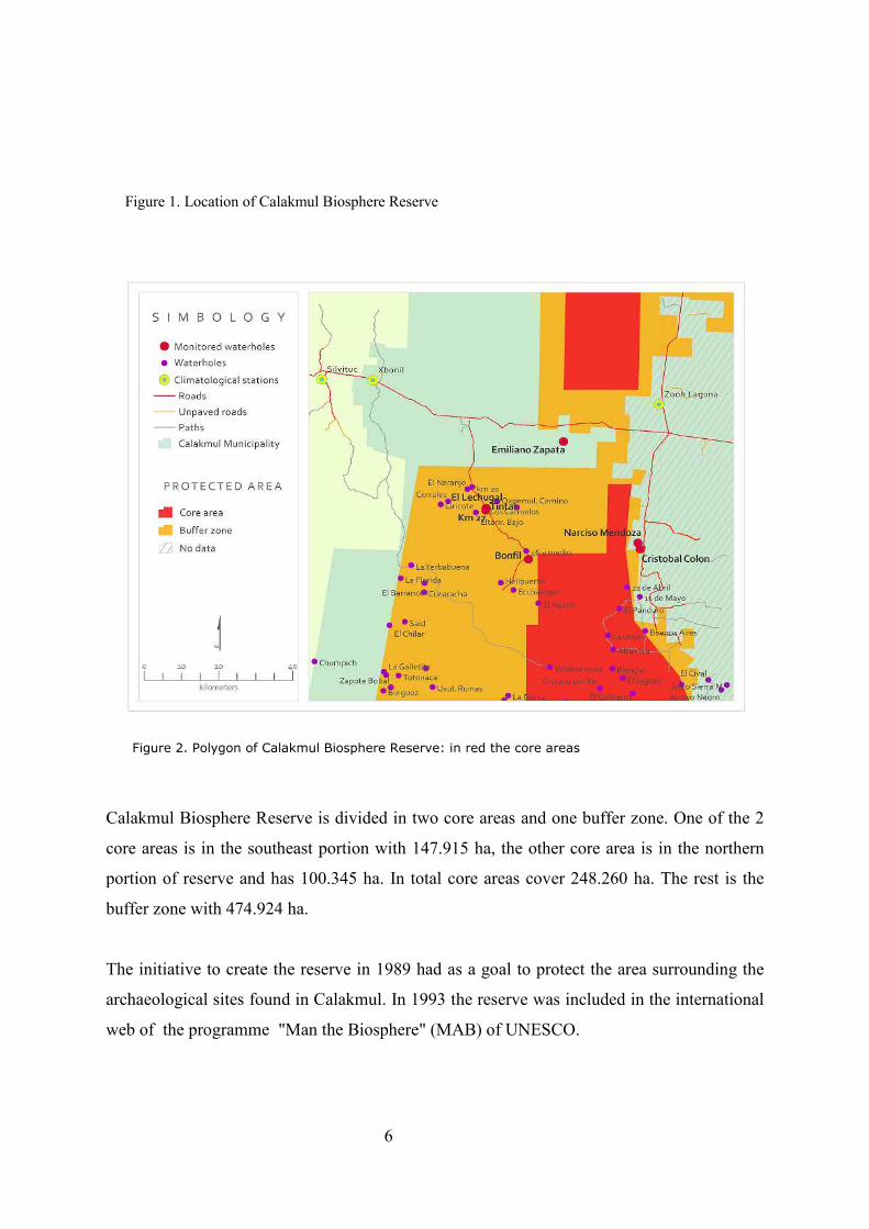
Figure 1. Location of Calakmul Biosphere Reserve
Figure 2. Polygon of Calakmul Biosphere Reserve: in red the core areas
Calakmul Biosphere Reserve is divided in two core areas and one buffer zone. One of the 2
core areas is in the southeast portion with 147.915 ha, the other core area is in the northern
portion of reserve and has 100.345 ha. In total core areas cover 248.260 ha. The rest is the
buffer zone with 474.924 ha.
The initiative to create the reserve in 1989 had as a goal to protect the area surrounding the
archaeological sites found in Calakmul. In 1993 the reserve was included in the international
web of the programme "Man the Biosphere" (MAB) of UNESCO.
7
Calakmul Reserve is part of the mesoamerican corridor where there is a flow of species from
the Yucatán Biotic Province, the Itsmo of Tehuantepec and the Guatemalan Petén.
There are around 86 mammal species in Calakmul of which 18 are included in the Norma
Oficial Mexicana de Ecología 059 (NOM-059-ECOL/1994), which determines species with
some degree of threat. Also five of the six species of felis in México live in Calakmul: jaguar
(Panthera onca), puma (Puma concolor), ocelote (Leopardus pardalis), tigrillo (Leopardus
wiedii) and leoncillo (Herpailurus yagouaroundi). More than 230 avian species have been
registered for the reserve, and between 3 y 5 million migratory birds come to spend the
winter every year.
Other important species of fauna that find refuge in Calakmul are: jabirú (Jabiru mycteria),
frogs Similisca cyanosticta, black vulture (Sarcoramphus papa), Eagles (Spizaetus ornatus),
tucans, parrots, six species of marsupials and 2 primates (alouatta palliata and Ateles
geoffroyi).
Futhermore, Calakmul is the only place in the American continent where the Canellaceae
family (flora) can be found.
Calakmul Reserve is a federal reserve; funding is provided by CONANP (Comisión Nacional
de Áreas Naturales Protegidas) and the Fondo Mexicano para la Conservación. Presently the
reserve has 19 people as staff: 1 Director, 1 vice Director, 1 General Coordinator , 2 special
technicians, 2 operative managers, 12 rangers. There are 3 annual programmes: the first
regarding preservation of landraised (or criollo) maize germoplasm and the other 2
promote sustainable activities and development of infrastructure in the communities.
Vegetation
According to Martínez and Galindo (2002) the ecosystems present in Calakmul include:
• Subtropical and subtropical dry broadleaf forest
• Tropical and subtropical grasslands, savannas, and shrublands
• Flooded grasslands and savannas

8
• Wetlands
• Riparian vegetation
• Secondary vegetation
Figure 3. Vegetation in Calakmul Biosphere Reserve
Change in vegetation in Calakmul Biosphere Reserve
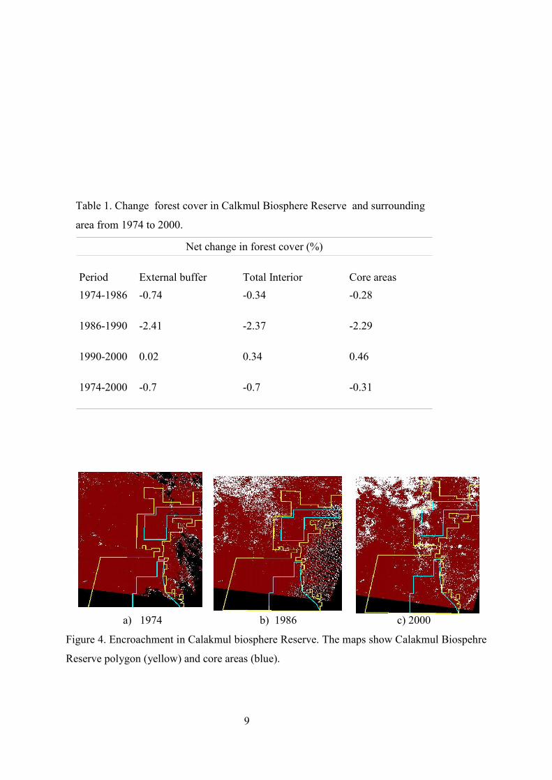
In Rayn-Villalba (2006) it was found that although the loss of vegetation cover slowed down
after the reserve was decreed in 1989, the poor reserve design has facilitated significant
impacts on flora and fauna, including the increase in deforestation in core areas. This was
exacerbated by the lack of clear definition of the uses of each part of the reserve. Table 1
figure 3 a,b,c
9
Table 1. Change forest cover in Calkmul Biosphere Reserve and surrounding
area from 1974 to 2000.
Net change in forest cover (%)
Period
External buffer
Total Interior
Core areas
1974-1986
-0.74 -0.34 -0.28
1986-1990
-2.41 -2.37 -2.29
1990-2000
0.02 0.34 0.46
1974-2000
-0.7 -0.7 -0.31
a) 1974 b) 1986 c) 2000
Figure 4. Encroachment in Calakmul biosphere Reserve. The maps show Calakmul Biospehre
Reserve polygon (yellow) and core areas (blue).

10
It was also found that the loss in forest cover was lower in the centre of the reserve regardless
of whether it was part of a core area or not. Population and road density by 2000 were also
lower in the center. This supported the idea that isolation from the edge provides protection.
Fauna
There are 75 species of reptiles and 18 species of amphibians in the reserve, which represents
70 percent of the amphibians found in the Yucatan Peninsula. Thirty-five of the species of
reptiles and 5 species of amphibians are considered threatened, in danger, rare, or in need of
special protection according to the Official Registry of Mexican Ecology. 31 species of fish
have been identified, most prominent of which is the family Chichilidae, represented by eight
species. Up to the year 2000, inventories of butterflies had documented 380 species, although
the total number is estimated at 500 (Pozo et al. 2001).
Herpetofauna
There are 18 amphibian species reported in Calkmul area (Pozo de la Tijera, 1988), which
represents 75% of the species found in Yucatán Peninsula. All the species belong to the
Order Anura, with 6 families represented; Bufonidae with 2 species, Rhinophrynidae with
one, Hylidae with two, Leptodactylidae with two, Mycrohylidae with two, and Ranidae also
with two.
There are 59 reptile species reported (Calderón, 1999) representing almost 32% of the 182
species in Yucatán Peninsula. Three Orders are represented; Crocodilya with one species
(Crocodylus moreletii) from the Crocodylidae family; Testudines, with five species from the
Bataguridae, Kinosternidae and Emydidae families, and Squamata with two Suborders Sauria
and Serpentes and 13 families.
Thirty-five of the species of reptiles and 5 species of amphibians are considered threatened,
in danger, rare, or in need of special protection according to the NOM-ECOL-059-2001
Ornitofauna

11
More than 350 avian species have been identified in Calakmul region, representing 62
families, 53% are whole year residents, 18% winter residents, 2% summer residents, 6%
transient, 2% altitudinal migrants, and 15% vagrants (Berlanga et al 2000; Semarnat, 1999).
Approximately one third of them are common to the Neotropical forests of Central and South
America; 9 species are endemic for Mesoamérica, 32 are threatened, including the king
vulture (Sarcoramphus papa), the hawk eagle (Spizaetus tyrannus), the ocellated turkey
(Agriocharis ocellata), and the royal duck (Cairina moschta), the latter being in danger of
extinction accoding to Nom-Ecol-59 (Instituto Nacional de Ecologia 1999).
Mastofauna.
There are 94 species of wild mammals registered in Calakmul, with 26 families and 9 orders
represented (Ceballos et al 2002, Cervantes et al, 1994; Semarnat, 1999, Ramírez et al,
1986). There are 47 species of Quiroptera, 15 species of Rodents and 16 species of
Carnivore. Felids are among the most notable, with five of the six species in Mexico present
in the reserve: the jaguar (Panthera onca), puma (Puma concolor), ocelot (Leopardus
pardalis), margay (Leopardus wiedii), and the jaguarondi (Herpaolurus yagouaroundi). Also
found in the region are six of the eight marsupials of Mexico, Marmosa canescens and
Didelphis marsupialis among them. Present as well in Calakmul are the howler monkey
(Alouatta pigra) and the spider monkey (Ateles geoffroyi) in danger of extinction and found
in the Yucatan Peninsula, Guatemala, and Belize. Other threatened species include the
anteater (Tamandua mexicana), the white-lipped peccary (Tajassu pecari), and the tapir
(Tapirus bairdii) (CONABIO 1998; Instituto Nacional de Ecologia 1999). Also present are
the Yucatán brown brocket deer (Mazama pandora), which is endemic to Mexico and the
white-tailed deer (Odocoileus virginianus).
Waterholes
The hydraulic system in Calakmul region has an important role in the distribution and
dynamics of flora and fauna populations. Water quality is poor due to excess in calcium
sulfates, so it is not drinkable for humans (Martínez-Kú 2007), so the main available source of
drinking water is rain stored in water holes (García-Gil, 2003). These water holes are swamp
like areas originated by erosion and sedimentation processes, together with a weather regime
in which precipitation and evaporation are in equilibrium. Vegetation consists mainly in
herbs and shrubs adapted to extreme conditions of flooding and drought, and keep humid

12
conditions in dry months. In Calakmul due to meteorological factors, soil permeability and
land use, many water holes dry up completely (García-Gil, 2003). García-Gil, 2003 registered
1,353 water holes in Calakmul Biosphere Reserve, of which 485 are in the south section of
the reserve and 868 in the north. Puc Cabrera (2008) found that water holes are of great
important for avian assembles, especially during dry season. They provide refuge, feeding and
nesting sites; its depth is associated with avian species richness. Martínez_Kú (2007) data
sustains that areas with water holes have more diversity of mid-size mammals during dry
season.
However, water holes in the north section are smaller and shallower thus more prone to dry
up. This implies that species move to the south during dry months. Moreover, permanent
water holes tend to be located in bigger numbers surrounding settlements (ejidos) (S. Calmé,
pers. com). As a result, individuals of species such as Tapir, White-lipped Peccary (Martínez-
Kú 2007, Rafael Reyna, 2005) and Jaguar, must go outside the limits of the reserve to get
water (March 1994, Hernandez-Huerta et al 2000, Escalona-Segura et al 2002, García-Gil
2003).
Socio-demographic and economic profile
There are 84 ejidos (communal land) with an estimate population of 25 thousand inhabitants
in Calakmul municipality; 30 of these ejidos are adjacent to Calakmul Biosphere Reserve.
Communities are rural, Xpujil being the largest settlement with a population of 1,213
inhabitants. There are approximately 3,000 inhabitants living inside the polygon (Pérez-
Espinoza pers. Com). The main human activities are agriculture and cattle (87%), with only
13% of the activities related to tourism, transport, commerce and construction, INEGI 2002
The main access is the federal highway No. 186 from Escárcega to Chetumal (west-east);
which divides the northern core area and the buffer area. There is another road from
Hopelchén (north-south) to Xpujil. This road cuts through the southern core area, and there
are other minor roads to Zoh Laguna and the archeological site within Calakmul. Most ejidos
are connected by smaller paved and unpaved roads INEGI 2002
Infrastructure and services in Calakmul are inadequate, the water is scarce in the region and
during dry season (November-June) the situation is critical (Steadman 1997, Morales y
Magaña 2001).

13
Current threats:
• Forest fires
• Population growth
• Conflict between the reserve and the population
• Illegal hunting
• Agriculture (slash and burn) and cattle
• Highways and roads
• Tourist infrastructure
• Faulty design of the polygon
• Lack of synergy and coordination between institutions and civil associations
Objectives
• To assess ecosystem integrity in relation to water availability in Calakmul Biosphere
Reserve and adjacent ejidos.
• To create alternative proposals for water management in Calakmul region, with
emphasis on community participation (i.e. voluntary reserves within adjacent ejidos)
Methods
• Data already available was collected from governmental and academic institutions in
order to be integrated.
• Selected water holes within and adjacent to Calakmul Biosphere Reserve were
monitored (direct observation, measurements and photographs).

14
• Visits to adjacent ejidos to interview local people to explore the possibility of
community participation in proposals such as voluntary reserves were carried out.
Interviews were based on a questionnaire.
Results
Precipitation
The region's basin is an important factor in precipitation trends, with summer conditions
diminishing precipitation in the region.. Summer rains are less than 60 mm during the
driest month, and the wind coming from the southeast finds the central plains resulting in
a perennial cloudiness on the west part of the Yucatán Peninsula. Due to the orography,
the hills would get more rain during summer and the rivers and streams will increase
thanks to the water sliding from the top. The percentage precipitation during winter is 5-
10 % (SEMARNAT, 1999). There are 3 climatological stations in the area:
Silvituc (Champotón),X-Bonil (Champotón) and Zoh-Laguna (Hopelchén). Annual media
calculated with data from the above stations for the years 1953 to 2007 is 1030.7 mm, for
wet season it is 700.8 mm and 85.3 for dry season. Graphs from the data available were
produced (Figures 6-8).
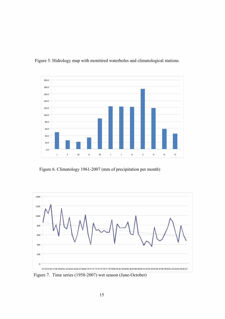
15
Figure 5. Hidrology map with monitired waterholes and climatological stations.
Figure 6. Climatology 1961-2007 (mm of precipitation per month)
Figure 7. Time series (1958-2007) wet season (June-October)
53 545556 5758 596061 626364 6566 676869 707172 7374 757677 787980 8182 838485 868788 8990 919293 949596 9798 990001 020304 0506 07
0
200
400
600
800
1000
1200
1400
J F M A M J J A S O N D
0.0
20.0
40.0
60.0
80.0
100.0
120.0
140.0
160.0
180.0
200.0
16
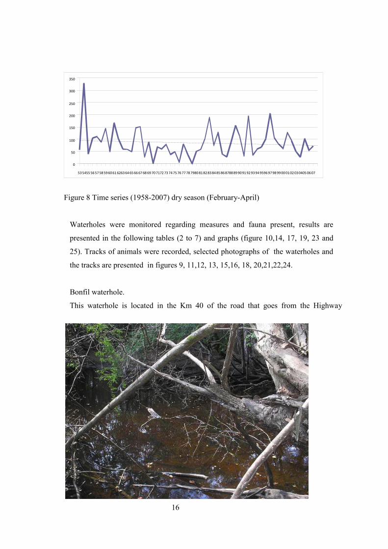
Figure 8 Time series (1958-2007) dry season (February-April)
Waterholes were monitored regarding measures and fauna present, results are
presented in the following tables (2 to 7) and graphs (figure 10,14, 17, 19, 23 and
25). Tracks of animals were recorded, selected photographs of the waterholes and
the tracks are presented in figures 9, 11,12, 13, 15,16, 18, 20,21,22,24.
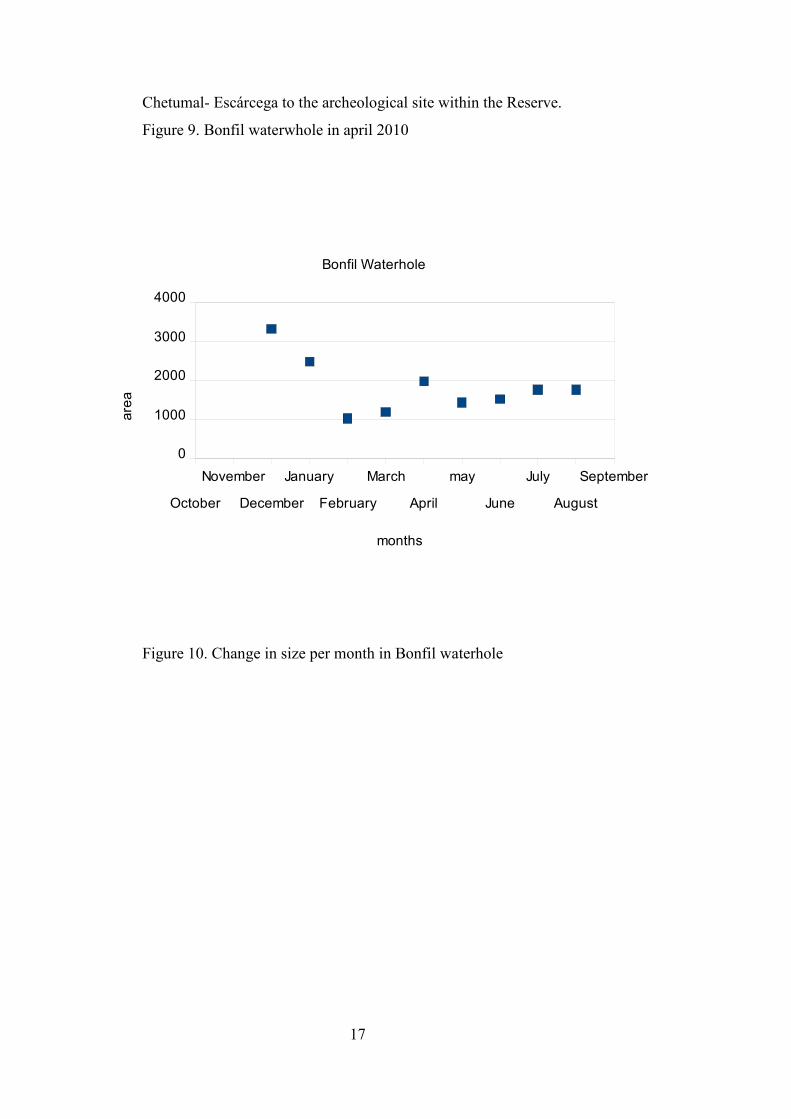
Bonfil waterhole.
This waterhole is located in the Km 40 of the road that goes from the Highway
53545556575859606162636465666768697071727374757677787980818283848586878889909192939495969798990001020304050607
0
50
100
150
200
250
300
350
17
Chetumal- Escárcega to the archeological site within the Reserve.
Figure 9. Bonfil waterwhole in april 2010
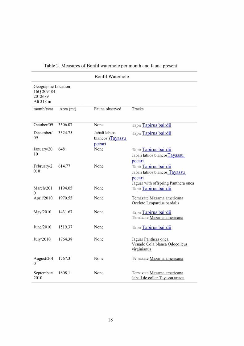
Figure 10. Change in size per month in Bonfil waterhole
October
November
December
January
February
March
April
may
June
July
August
September
0
1000
2000
3000
4000
Bonfil Waterhole
months
area
18
Table 2. Measures of Bonfil waterhole per month and fauna present
Bonfil Waterhole
Geographic Location 16Q 209484 2012689 Alt 318 m
month/year Area (mt) Fauna observed Tracks
October/09 3506.07 None Tapir Tapirus bairdii
December/09
3324.75 Jabalí labios blancos )Tayassu pecari
Tapir Tapirus bairdii
January/2010
648 None Tapir Tapirus bairdii Jabali labios blancosTayassu pecari
February/2010
614.77 None Tapir Tapirus bairdii Jabali labios blancos Tayassu pecari Jaguar with offspring Panthera onca
March/2010
1194.05 None Tapir Tapirus bairdii
April/2010 1970.55 None Temazate Mazama americana Ocelote Leopardus pardalis
May/2010 1431.67 None Tapir Tapirus bairdii Temazate Mazama americana
June/2010
1519.37 None Tapir Tapirus bairdii
July/2010 1764.38 None Jaguar Panthera onca, Venado Cola blanca Odocoileus virginianus
August/2010
1767.3 None Temazate Mazama americana
September/2010
1808.1 None Temazate Mazama americana Jabalí de collar Tayassu tajacu
19
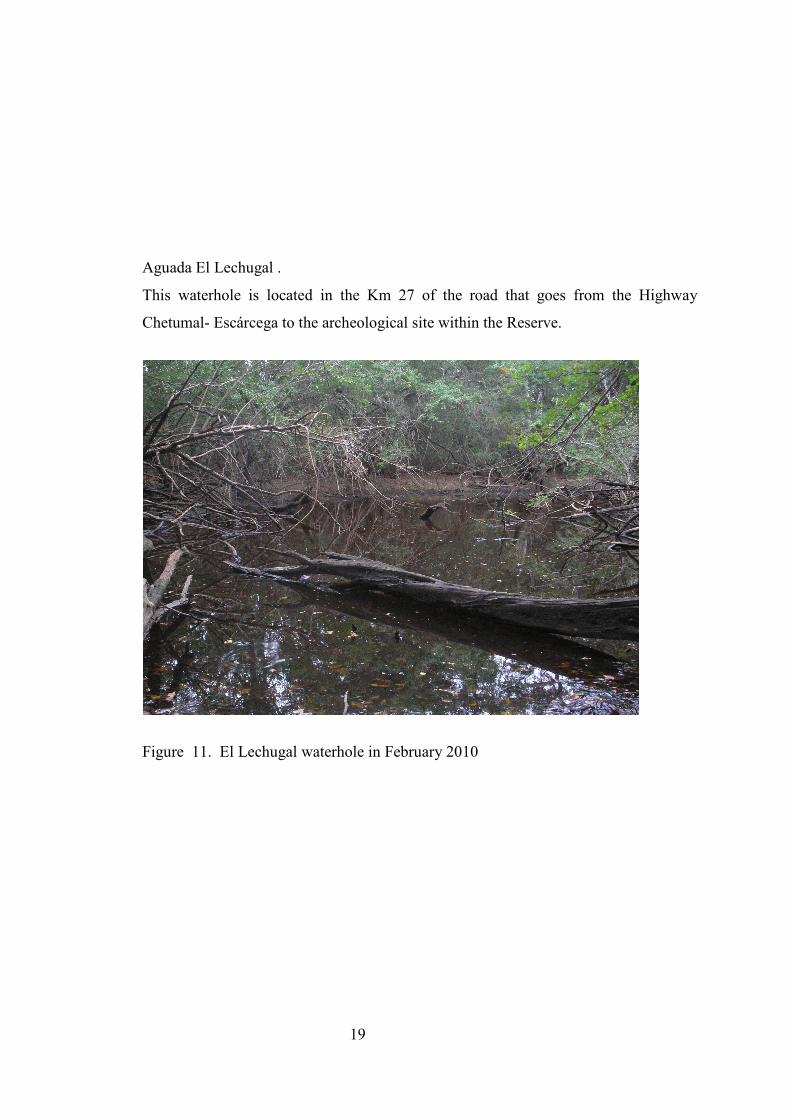
Aguada El Lechugal .
This waterhole is located in the Km 27 of the road that goes from the Highway
Chetumal- Escárcega to the archeological site within the Reserve.
Figure 11. El Lechugal waterhole in February 2010

20
Figure 12. Odocoileus virginianus footprints in El Lechugal waterhole
Figure 13. Tayasu tajacu footprints in El Lechugal waterhole

21
Figure 14. Change in size per month in El Lechugal waterhole
October
November
December
January
February
March
April
may
June
July
August
September
0
500
1000
1500
2000
Km 27 El Lechugal Waterhole
months
area

22
Table 3. Measures of El Lechugal waterhole per month and fauna present
Km 27 /El Lechugal Waterhole
Geographic Location 16Q 0198064 2026855 ALT 223 m month/year Area
(mt) Fauna observed Tracks
October/09 804.3 Crocodylus moreletti Venado cola blanca Odocoileus virginianus
December/09
755.74 Crocodylus moreletti
Jaguar Panthera onca
January/2010
648 Crocodylus moreletti Jabalí de collar Tayassu tajacu
Venado cola blanca Odocoileus virginianus Jaguar Panthera onca
February/2010
614.77 Crocodylus moreletti Venado cola blanca Odocoileus virginianus Jabalí de collar Tayassu tajacu Jaguar Panthera onca
March/2010 594.55 Crocodylus moreletti Tejón Nasua narica Jabalí de collar Tayassu tajacu
April/2010 341.91 Crocodylus moreletti Venado cola blanca Odocoileus virginianus
Jabalí de collar Tayassu tajacu
May/2010 573.19 Crocodylus moreletti Pavo ocelado Meleagris ocellata
Venado cola blanca Odocoileus virginianus
June/2010 608.93 Crocodylus moreletti Pavo ocelado Meleagris ocellata
July/2010 1536 Crocodylus moreletti Jabali Labios blancos Tayassu pecari
August/2010
448 Crocodylus moreletti Jabali Labios blancos Tayassu pecari Venado cola blanca Odocoileus virginianus
September/2010
418.11 Venado cola blanca Odocoileus virginianus Crocodylus moreletti Allouatta palliata
23
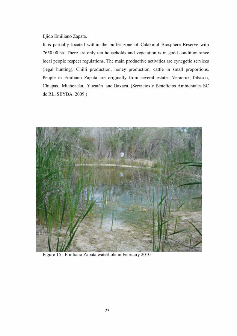
Ejido Emiliano Zapata.
It is partially located within the buffer zone of Calakmul Biosphere Reserve with
7650.00 ha. There are only ten households and vegetation is in good condition since
local people respect regulations. The main productive activities are cynegetic services
(legal hunting), Chilli production, honey production, cattle in small proportions.
People in Emiliano Zapata are originally from several estates: Veracruz, Tabasco,
Chiapas, Michoacán, Yucatán and Oaxaca. (Servicios y Beneficios Ambientales SC
de RL, SEYBA. 2009.)
Figure 15 . Emiliano Zapata waterhole in February 2010
24
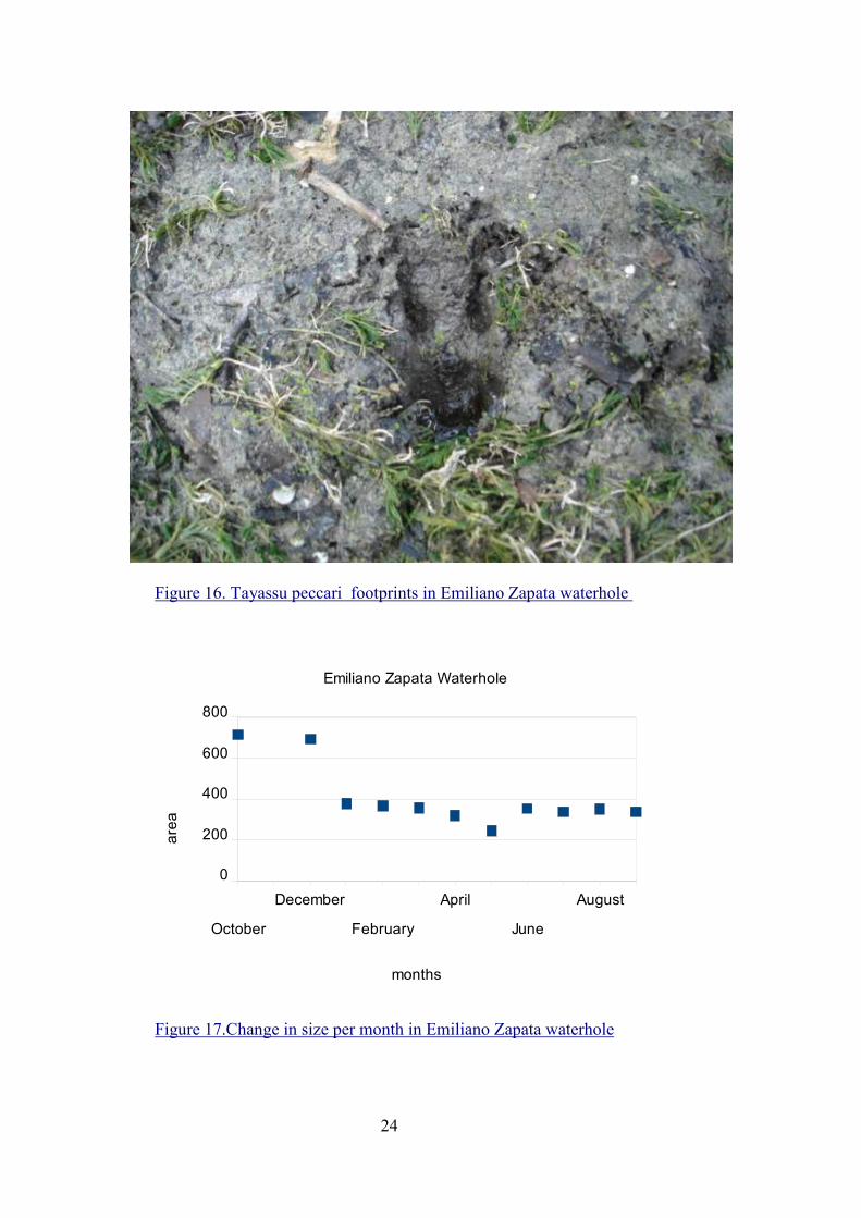
Figure 16. Tayassu peccari footprints in Emiliano Zapata waterhole
Figure 17.Change in size per month in Emiliano Zapata waterhole
October
December
February
April
June
August
0
200
400
600
800
Emiliano Zapata Waterhole
months
area
25
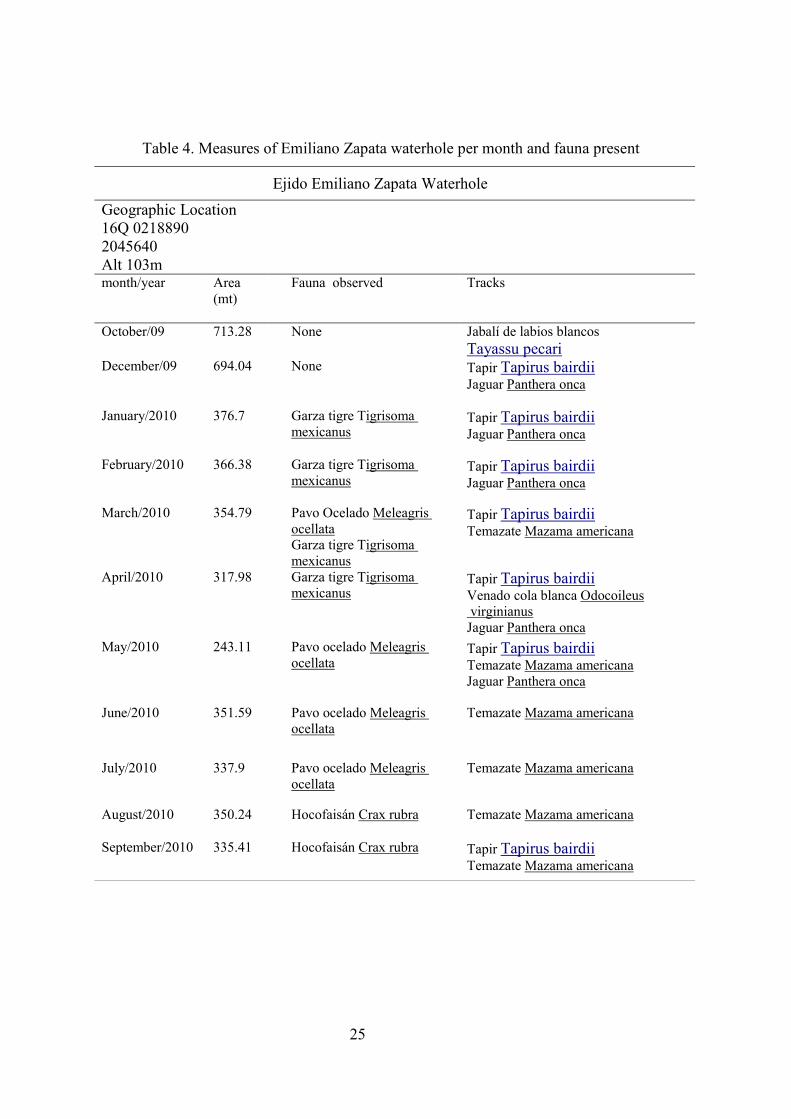
Table 4. Measures of Emiliano Zapata waterhole per month and fauna present
Ejido Emiliano Zapata Waterhole
Geographic Location 16Q 0218890 2045640 Alt 103m month/year Area
(mt)
Fauna observed Tracks
October/09 713.28 None Jabalí de labios blancos Tayassu pecari
December/09 694.04 None Tapir Tapirus bairdii Jaguar Panthera onca
January/2010 376.7 Garza tigre Tigrisoma mexicanus
Tapir Tapirus bairdii Jaguar Panthera onca
February/2010 366.38 Garza tigre Tigrisoma mexicanus
Tapir Tapirus bairdii Jaguar Panthera onca
March/2010 354.79 Pavo Ocelado Meleagris ocellata Garza tigre Tigrisoma mexicanus
Tapir Tapirus bairdii Temazate Mazama americana
April/2010 317.98 Garza tigre Tigrisoma mexicanus
Tapir Tapirus bairdii Venado cola blanca Odocoileus virginianus Jaguar Panthera onca
May/2010 243.11 Pavo ocelado Meleagris ocellata
Tapir Tapirus bairdii Temazate Mazama americana Jaguar Panthera onca
June/2010
351.59 Pavo ocelado Meleagris ocellata
Temazate Mazama americana
July/2010 337.9 Pavo ocelado Meleagris ocellata
Temazate Mazama americana
August/2010 350.24 Hocofaisán Crax rubra Temazate Mazama americana
September/2010 335.41 Hocofaisán Crax rubra Tapir Tapirus bairdii Temazate Mazama americana
26
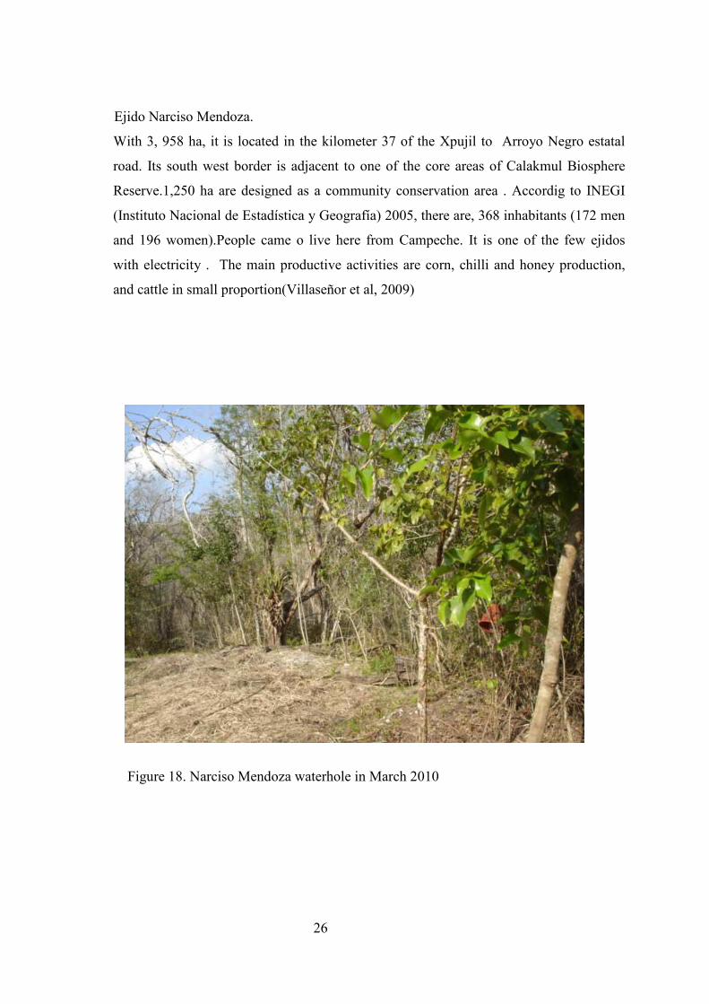
Ejido Narciso Mendoza.
With 3, 958 ha, it is located in the kilometer 37 of the Xpujil to Arroyo Negro estatal
road. Its south west border is adjacent to one of the core areas of Calakmul Biosphere
Reserve.1,250 ha are designed as a community conservation area . Accordig to INEGI
(Instituto Nacional de Estadística y Geografía) 2005, there are, 368 inhabitants (172 men
and 196 women).People came o live here from Campeche. It is one of the few ejidos
with electricity . The main productive activities are corn, chilli and honey production,
and cattle in small proportion(Villaseñor et al, 2009)
Figure 18. Narciso Mendoza waterhole in March 2010
27
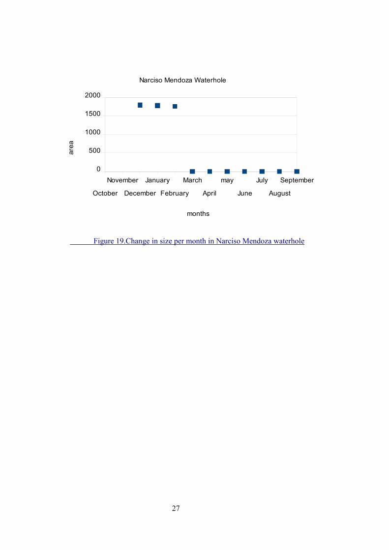
Figure 19.Change in size per month in Narciso Mendoza waterhole
October
November
December
January
February
March
April
may
June
July
August
September
0
500
1000
1500
2000
Narciso Mendoza Waterhole
months
area
28
Table 5. Measures of Narciso Mendoza waterhole per month and fauna present
Ejido Narciso Mendoza Waterhole
Geographic Location 16Q 0238920 2017216 month/year
X (mt) side a
Fauna observed Tracks
October/09
No data
No data No data
December/09
1790.43
None Tapir Tapirus bairdii
January/2010
1782.46
Tapir Tapirus bairdii Tapir Tapirus bairdii
February/2010
176103
Tapir Tapirus bairdii Tapir Tapirus bairdii
March/2010
dry
None None
April/2010
dry
None None
May/2010
dry
None None
June/2010
dry
None None
July/2010 dry None
None
August /2010
dry None None
September/2010
dry None None
Ejido Cristobal Colon
With a surface of 14,681 km2 , this communiy is located 36 km. South from Xpujil.
Access is through the Chetumal- Escárcega highway. It is adyacent to the Calakmul
Biosphere Reserve, 3 km from one of the core areas, and is part of the Mesoamerican
Corridor. It limits with Narciso Mendoza. The main productive activities are corn, chilli
and honey production, and cattle in small proportion.
There are 300 inhabitants and vegetation is in good condition (Pérez Espinoza F. pers.
29
Com 2010). Funding members came from several estates like in most ejidos
around: Veracruz, Tabasco, Chiapas, Michoacán, Yucatán and Oaxaca
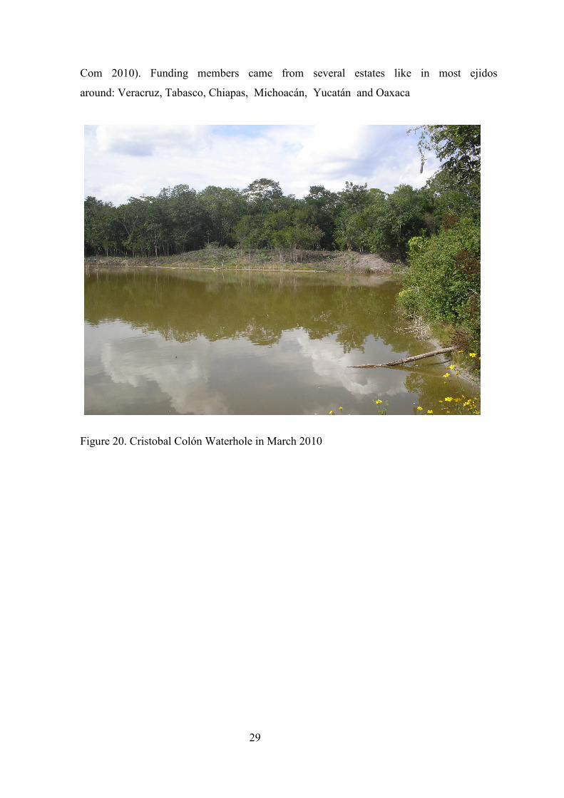
Figure 20. Cristobal Colón Waterhole in March 2010

30
Figure 21. Ocelote Leopardus pardalis footprints in Cristobal Colón waterhole
Figure 22. Procyon lotor fooprints in Cristóbal Colón waterhole
31
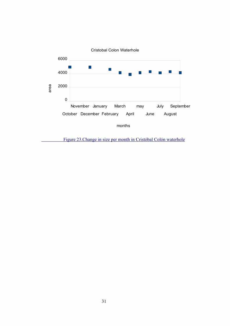
Figure 23.Change in size per month in Cristóbal Colón waterhole
October
November
December
January
February
March
April
may
June
July
August
September
0
2000
4000
6000
Cristobal Colon Waterhole
months
area
32
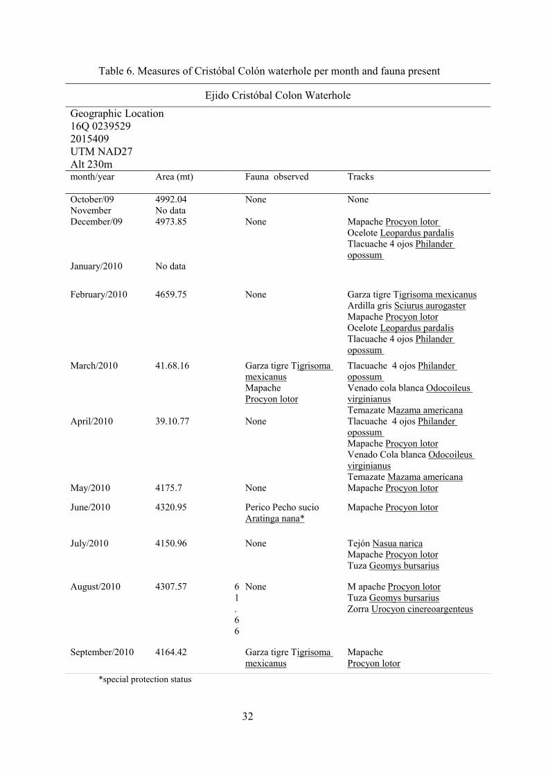
Table 6. Measures of Cristóbal Colón waterhole per month and fauna present
Ejido Cristóbal Colon Waterhole
Geographic Location 16Q 0239529 2015409 UTM NAD27 Alt 230m month/year Area (mt)
Fauna observed Tracks
October/09 4992.04 None None November No data December/09 4973.85 None Mapache Procyon lotor
Ocelote Leopardus pardalis Tlacuache 4 ojos Philander opossum
January/2010 No data
February/2010 4659.75 None Garza tigre Tigrisoma mexicanus Ardilla gris Sciurus aurogaster Mapache Procyon lotor Ocelote Leopardus pardalis Tlacuache 4 ojos Philander opossum
March/2010 41.68.16 Garza tigre Tigrisoma mexicanus Mapache Procyon lotor
Tlacuache 4 ojos Philander opossum Venado cola blanca Odocoileus virginianus Temazate Mazama americana
April/2010 39.10.77 None Tlacuache 4 ojos Philander opossum Mapache Procyon lotor Venado Cola blanca Odocoileus virginianus Temazate Mazama americana
May/2010 4175.7 None Mapache Procyon lotor
June/2010 4320.95 Perico Pecho sucio Aratinga nana*
Mapache Procyon lotor
July/2010 4150.96 None Tejón Nasua narica Mapache Procyon lotor Tuza Geomys bursarius
August/2010 4307.57 61.66
None M apache Procyon lotor Tuza Geomys bursarius Zorra Urocyon cinereoargenteus
September/2010 4164.42 Garza tigre Tigrisoma mexicanus
Mapache Procyon lotor
*special protection status
33
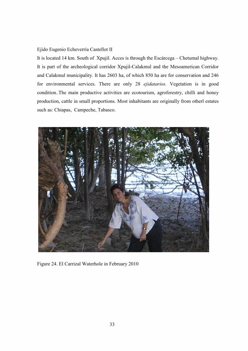
Ejido Eugenio Echeverría Castellot II
It is located 14 km. South of Xpujil. Acces is through the Escárcega – Chetumal highway.
It is part of the archeological corridor Xpujil-Calakmul and the Mesoamerican Corridor
and Calakmul municipality. It has 2603 ha, of which 850 ha are for conservation and 246
for environmental services. There are only 28 ejidatarios. Vegetation is in good
condition..The main productive activities are ecotourism, agroforestry, chilli and honey
production, cattle in small proportions. Most inhabitants are originally from otherl estates
such as: Chiapas, Campeche, Tabasco.
Figure 24. El Carrizal Waterhole in February 2010
34
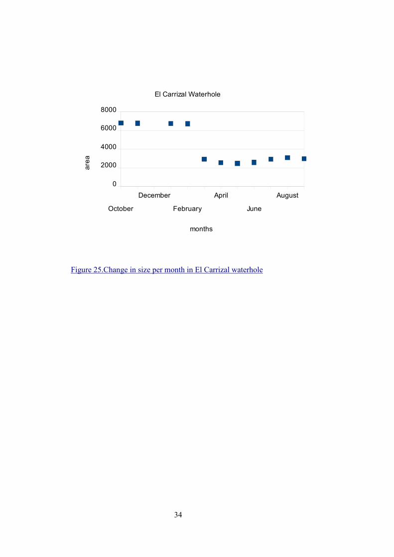
Figure 25.Change in size per month in El Carrizal waterhole
October
December
February
April
June
August
0
2000
4000
6000
8000
El Carrizal Waterhole
months
area

35
Table 7. Measures of the waterhole per month and fauna present
El Carrizal Waterhole
Geographic Location 16Q 0197927 2026428 month/year Area (mt)
Fauna observed Tracks
October/09
No data
November No data
December/09
6834.16 None Tapir Tapirus bairdii Venado Cola Blanca Odocoileus virginianu
January/2010
6784.56 None Tapir Tapirus bairdii Venado Cola Blanca Odocoileus virginianu
February
6726.24 None Tapir Tapirus bairdii Venado Cola Blanca Odocoileus virginianus Puma concolor
March
2928.49 Pavo Ocelado Meleagris ocellata
Tejón Nasua narica Mapache Procyon lotor
April 25741.4 None Tejón Nasua narica Pavo Ocelado Meleagris ocellata Mapache Procyon lotor
May 2461.38 None Temazate Mazama americana
June 2568.23 Pavo ocelado Meleagris ocellata
Temazate Mazama americana
July 2906.79 Falco sparverius Temazate Mazama americana
August/2010 3063.32 Garza tigreTigrisoma mexicanus
Jabalí de collar Tayassu tajacu Temazate Mazama americana
September/2010 2958.12 None Pavo ocelado Meleagris ocellata Temazate Mazama americana

36
Conclusions and Recommendations
Waterholes located in adjacent ejidos have an important role for species protected by
Calakmul Biosphere Reserve. This study found, as March 1994, Hernández-Huerta et
al 2000, Escalona-Segura et al 2002, García –Escalona 2003, García-Gil 2003,
Martínez-Kú 2007 did before, that many species of fauna have to get out of the reserve
to find water to drink. Species found in the waterholes located within ejidos adjacent
to the reserve are the most vulnerable to variations in water level. There are species of
great importance such as Tapir, White-lipped Peccary and Jaguar, that wander outside
the reserve in search of water. The case of predators such as the Jaguar is specially
relevant since the probability of attacks to cattle and other farm animals increases,
which creates animosity towards such animals.
It is important to protect these species during the dry months when they need to have
access to alternate sources of water. We found that species use the waterholes in the
ejidos all year long and the same species show if the waterhole persist. In that respect
it is necessary to take protective measures and keep waterholes available to them. This
measures must facilitate the maintenance and improvement if possible of the quality of
the water and the ecosystem surrounding the waterhole, the protection of the fauna
from illegal hunters and poachers and the mitigation/management of possible predator
attacks. This measures must not be imposed by the Reserve but must come from the
inhabitants of the communities, although reserve staff should provide guidance and
cooperation.
In all ejidos that were visited favorable conditions were found for the implementation of
internal (ejidales) regulations that would allow to protect waterholes and fauna within
the ejido.
Suggested measures are as follow:
• Vigilance of the waterhole by locals (ejidatarios) to avoid illegal hunting and
poaching
37
• Keep the waterhole and its surroundings clean and free from trash, plastic, detergent,
oil, gasoline and all man made products
• Avoid logging and burning of nearby vegetation
• Regulation of fisheries if it applies
• Work with the appropriate authorities (CONANP, SAGARPA, SEMARNAP) to
improve cattle management and implement protective measures in case there is the
risk of a predator attack that endangers cattle and property (instead of killing the
predator themselves).
The last point is the most conflictive since protective measures are expensive and
authorities do not always respond promptly (Pérez Espinoza F. pers. Com 2010). ; people in the
ejidos feel they have the right to protect their property
Future Work
Mapping and monitoring of adjacent waterholes must continue and extend to all known
waterholes. It is also relevant to continue with the analysis of meteorological data; in
this way it would be possible to anticipate which waterholes would be particularly
important during droughts and to prevent situations such as predators attacks by
implementing protective measures on time.
The situation in all adjacent ejidos must be explored regarding its disposition to protect
waterholes within its limits and the species that approach it to drink and act
accordingly as mentioned in the previous section. If resistance towards this measures
is found it is suggested to start with environmental education programs that highlight
the importance and benefits of the waterhole for the ejido and its population and the
possible mitigation measures that can be taken in case of a predator attack to cattle and
other farm animals.

References
Aranda M., 1990. El Jaguar (Panthera onca) en la Resrerva de la Biosfera de Calkmul, México: morfometría,
hábitos alimentarios y densidad de población. Tesis de Maestría. Sistema de estudios de posgrado.
Programa regional en Manejo de Vida Silvestre para mesoamérica y el Caribe. Universidad Nacional de
Costa Rica. 93 pp.
Arriaga, L. M., J. M. Espinoza, C. Aguilar, E. Martinez, L. Gomez, and E. Loa. 2000. Regiones terrestre
prioritarias de Mexico. CONABIO.
Berlanga_Cano, M y P. Word, J. Salgado y E. Figueroa 2000. AICA171.Áreas de importancia para la
conservación de las aves en México. Arizmendi, M. y L. Márquez coordinadores CONABIO, México.
Calderón, R. 1999Los reptiles de la Reserva de Calakmul, Campeche, México. Tesis de Licenciatura.
Universidad Michoacana de San Nicolás de Hidalgo.
Calmé S. pers. Com 2008
Ceballos G., C. Chávez, A.Rivera, C. Manterola y B. Wall. 2002. Tamaño poblacional y conservación del jaguar
en la Reserva de la Biosfera de Calakmul. En: R. Medellín, C. Equihua, C. Chetkiewies, P. Crawshaw,
A. Rabinowitz, K. Redford, J. Robinsony A. Taber, (eds.). El Jaguar en el Nuevo milenio. Primera
edición. Fondo de Cultura Económica, México, D.F., p.p.403-417
Cervantes F., A. Castro-Campillo, y J. Ramírez-Pulido, 1994. Mamíferos terrestres nativos de México. Serie
Zoológica.65:177-290.
CONABIO. 1998. Estudio de Pais. CONABIO, Mexico.
Escalona-Segura, G. J., Vargas-Contreras y L. Interián-Sosa. 2002. Registros importantes en mamíferos para
Campeche, México. Revista Mexicana de Mastozoología. 6:99-103.
Galindo-Leal, C. 1999 La gran Región de Calakmul, Campeche: Prioridades biológicas de conservación y
propuesta de modificación de la Reserva de la Biosfera. Reporte final a World Wildlife Fund-México,
D.F. 40 pp.
García, E. 1973. Modificación al sistema de clasificación de Copen (para adaptarlo a las condiciones de la
República Mexicana). Instituto de Geografía. Universidad Nacional Autónoma de México.
García –Escalona, M. S. Calmé, B. Millar y E. Escobedo-Barrera, 2003. Murciélagos asociados a aguadas en la
región de Calakmul, Campeche, México. En: Boletín Oficial de la Sociedad Mesoamericana para la
Biología y la Conservación (eds). VII Congreso Mesoamericano para la Biología y la Conservación.
Centro de Convenciones de Tuxtla Gutiérrez, Chiapas, México.
García-Gil, G. 2003. Colonización humana reciente y formación del paisaje agrario en la Reserva de la Biosfera
de Calakmul, Campeche, México. Tesis de doctorado. Facultad de Filosofía y Letras. Universidad
Autónoma de México.
Gobierno de estado de Campeche, 2000. Enciclopedia de los municipios de México. Campeche, Calakul.
Centro Nacional de Desarrollo Municipal. http://www.e-local.gob.mx/enciclo/campeche/
Hernández-Huerta A, V. Sosa, M. Aranda y J. Bello 2000. Records of small mammals in the Calakmul
Biosphere Reserve, Yucatán Península. The Southwestern Naturalist.45340-344.

Instituto Nacional de Estadística Geografía e Informática, I. 2002. "Localidades de la República Mexicana,
2000". Obtenido de Principales Resultados por Localidad. XII Censo de Población y Vivienda 2000. In:
C. N. p. e. C. y. U. d. l. B. (CONABIO). Editor.
March 1994. Situación actual del tapir en México. Serie Monográfica 1. Centro de Investigaciones Ecológicas
del Sureste (CIES). San Cristóbal de las Casas, Chiapas, México.
Martínez, E. y C. Galindo (2002). La vegetación de Calakmul, Campeche, México: Clasificación, descripción y
distribución. Boletín de la Sociedad Botánica de México. 71:7-32
Martínez-Kú 2007. Importancia de las aguadas para los mamíferos de talla mediana y grande en Calakmul,
Campeche, México. Tesis de licenciatura. Facultad de Ciencias Químico Biológicas. Universidad
Autónoma de Campeche, Campeche, México.
Mandujano and Gallina, 1995. Disponibilidad de agua para el veado cola blanca en un bocque tropical
caducifolio de México. Vida Silvestre Neotropical. 4:107-118.
Medellín G. y Ceballos. Avances en el estudio de los mamíferos de México.Asociación mexicana de
mastozoología A.C. México D.F. 464 pp
Morales, J. y R. Magaña 2001. Fuentes de impacto, necesidades de investigación científica y monitoreo en
Calakmul, Campeche. Probatura Península de Yucatán, A.C. The Nature Conservancy. 72 pp
Naranjo, E. 2001. El Tapir en México. Biodiversitas 36:1-3.
Norma oficial mexicana NOM-059-ECOL-2001. Protección ambiental- Especies nativas de México de flora y
fauna silvestres-Categorías de riesgo y especificaciones para si inclusión, exclusión o cambio-Lista de
especies en riesgo.Publicada en el Diario Oficial el 06 Marzo del 2002
Pérez Espinoza F. pers. Com 2009
Pérez Espinoza F. pers. Com 2010
Pozo, C., Galindo-Leal, C., Cedeño-Vázquez, J.R., Calderón, R., Tescum, UC., Tuz, N. y Maya Martínez. 2001.
Inventario y monitoreo de anfibios, reptiles y mariposas de la Reserva de la Biosfera de Calakmul,
Campeche. Fase II. Reporte final. ECOSUR, CONABIO. Q. Roo. 41 pp.
Pozo de la Tijera, C. , C. Galindo-Leal, R. Cedeño Vásquez, y R. Calderón. 1998. Herpetofauna de la Reserva
de Biósfera de Calkmul, Campeche. ECOSUR-PPY. México. 17 pp.
Ramírez Pulido, J., M. Claire, A. Perdomo y A. Castro. 1986. Guía de los mamíferos de México. Universidad
Autónoma de México. México. 720 pp.
Rayn-Villalba D. 2006. Factors affecting the efficacy of selected protected areas of central and southern
Mexico. PhD Thesis, School of Biological Sciences, University of East Anglia, UK.
Reyna-Hurtado Rafael and G.W. Tanner. 2005. Habitat Preferences of Ungulates in Hunted and Nonhunted Areas in the Calakmul Forest, Campeche, Mexico. Biotropica 37:4 676-685.
SEMARNAT, 1999 Programa de Manejo de la Reserva de la Biosfera de Calakmul, México. Instituto Nacional
de Ecología-SEMARNAT.
Steadman-Edwards, P. 2000. Mexico: Calakmul Reserve. in A. P. Wood, P. Steadman-Edwards, and J. Mang,
editors. The Root Causes of Biodiversity loss. Earthscan/WWF, London
SEYBA (Servicios y beneficios ambientales SC de RL) 2008. Estudio de Ordenamiento territorial. (CONAFOR)
SEYBA (Servicios y beneficios ambientales SC de RL) 2009. Estudio de Ordenamiento Territorial
Comunitario del Ejido Emiliano Zapata. Comisión Nacional Forestal, Programa de Desarrollo Forestal

Comunitario (PROCYMAF) y Reserva de la Biosfera de Calakmul)
Vaughan, C. y K. Weiss. 1999. Neotropical dry forest wildlife waterhole use and management. Regional
Wildlife Program. Univeridad Nacional Heredia, Costa Rica.
Villaseñor, F. A., y C. Palafox. 2009. Estudio de Ordenamiento Territorial Comunitario del
Ejido Narcizo Mendoza, Calakmul, Campeche. Comisión Nacional Forestal y Tropical
Rural SPR de RL de CV. Pág. 33.).
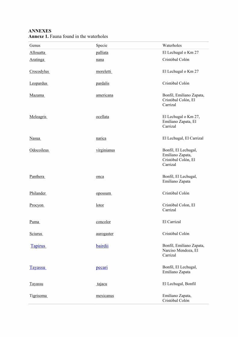
ANNEXES Annexe 1. Fauna found in the waterholes
Genus Specie Waterholes
Allouatta palliata El Lechugal o Km 27
Aratinga nana Cristóbal Colón
Crocodylus moreletti El Lechugal o Km 27
Leopardus pardalis Cristóbal Colón
Mazama americana Bonfil, Emiliano Zapata, Cristóbal Colón, El Carrizal
Meleagris ocellata El Lechugal o Km 27, Emiliano Zapata, El Carrizal
Nasua narica El Lechugal, El Carrizal
Odocoileus virginianus Bonfil, El Lechugal, Emiliano Zapata, Cristóbal Colón, El Carrizal
Panthera onca Bonfil, El Lechugal, Emiliano Zapata
Philander opossum Cristóbal Colón
Procyon lotor Cristóbal Colon, El Carrizal
Puma concolor El Carrizal
Sciurus aurogaster Cristóbal Colón
Tapirus bairdii Bonfil, Emiliano Zapata, Narciso Mendoza, El Carrizal
Tayassu pecari Bonfil, El Lechugal, Emiliano Zapata
Tayassu tajacu El Lechugal, Bonfil
Tigrisoma mexicanus Emiliano Zapata, Cristóbal Colón

Annexe 2. Questionnaire
Semi-structured interview
Name of interviewer:
Place and date:
Name of interviewee:
Age:
Sex:
Where are you from? How long have you (or your ancestors) lived here?
Do you know the limits of Calakmul Biosphere Reserve?
How do people living within the region make use of the resources available?
How do people living outside the region make use of the resources available?
Do people use the timber? How and since when?
Do you use any other natural resource? How and since when?
Changes in species sighting and predator attacks (i.e. Jaguar)
What species of animals use to live in Calakmul?
When was the last time you or anyone else saw one? Which one?
Why do you think they disappeared?
What species of animals still live in Calakmul?
Have you seen them or any evidence of its presence (excretes burrows or footprints?
What animals are used and what for? (Hunting, food, medicine, sale, other)
Do you know where the animals are usually found? Do you know the places where there is more
abundance? (in the map)

Where do you and other people living in Calakmul get water?
Can you get water all year long?
What do you use water for?
Do you know where the main stream, rivers, and waterholes in the region are?
Do you know the names?
Do you know if people from outside uses the water?
Do you know if the distribution of stream, rivers or water holes has change?
If it has, why do you think it happened?
When is the rainy season? Has it changed? How and since when?
Why do you think it has changed?
Are there any places where the soil is washed down when it rains?
Where? (Map)
Do you remember if any of these events has affected the region in the last 10 years?
Draughts
Floodings
Mudslide
Hurricans
Has the climate changed in any way?
How and since when?
Why do you think it has changed?