Embed Size (px)
Citation preview
1998-2017
EconomicLosses,
Poverty &DISASTERS
Economic
1998-2017
Losses,Poverty &
DISASTERS
Economic Losses, Poverty and Disasters 1998-2017 | 01
If development and economic growth are not risk informed, they are not sustainable and can undermine efforts to build resilience. The economic losses which often ensue from the creation of new risk or exacerbation of existing levels of risk can have a significant human cost.
That human cost is there for all of us to see in the alarming numbers of people who are now internally displaced every year by disasters, often losing their homes and their livelihoods, in extreme weather events and earthquakes.
We live in a world where the bar for resilience is constantly being raised by human actions. The most egregious failure in this regard is the lack of political will and commitment to make serious progress on reducing greenhouse gas emissions, thus allowing climate change to play an increasingly important role in driving up disaster losses around the world for the foreseeable future.
As the UN Secretary-General has recently warned: “If we do not change course by 2020, we risk missing the point where we can avoid runaway climate change, with disastrous consequences for people and all the natural systems that sustain us.”
Alongside the global push by the UN and other stakeholders for reductions in greenhouse gas emissions, there is also widespread recognition that we need to accelerate implementation of the Sendai Framework for Disaster Risk Reduction 2015-2030, the global plan to reduce disaster losses by reducing existing levels of risk, avoiding the creation of new risk and managing risks that cannot be eliminated.
These words must translate into actions which lead to robust institutions tasked with disaster risk management, enforcement of land use regulations, implementation of building codes, preservation of protective eco-systems, risk-informed urban development and special attention to the housing needs of the poor and vulnerable in society.
The focus of this report is on Sendai Framework target (c) which seeks to “reduce direct disaster economic loss in relation to global gross domestic product (GDP) by 2030.” This is also the theme of this year’s International Day for Disaster Reduction, on October 13.
In particular, the report highlights the ever widening “protection gap” that exists between rich and poor across the planet. It is often said that those who suffer the most from climate change are those who contribute least to it. We are acutely reminded that disasters are a combination of hazard, exposure and vulnerability.
It is also clear that the economic losses suffered by low and lower-middle income countries have crippling consequences for their future development and undermine our efforts to achieve the 17 Sustainable Development Goals, in particular the eradication of poverty.
There is a deeper understanding today than ever before of the underlying factors which drive up the likelihood of a future disaster event. More and more countries are moving to put in place national and local strategies for disaster risk reduction by 2020, in line with target (e) of the Sendai Framework.
It is our hope that this report will encourage those efforts with further evidence that reducing disaster risk and building resilience is essential to sustainable development.
Mami Mizutori Special Representative of the Secretary-General for Disaster Risk Reduction, Head of the UN Office for Disaster Risk Reduction
Debarati Guha-SapirProfessor, Centre for Research on the Epidemiology of Disasters, Institute of Health and Society, Université catholique de Louvain, Belgium.
Foreword
02 | Economic Losses, Poverty and Disasters 1998-2017
Who we are
CREDThe Centre for Research on the Epidemiology of Disasters (CRED) is the world’s foremost agency for the study of public health during mass emergencies, including the epidemiology of diseases, plus the structural and socio-economic impacts of natural and technological disasters and human conflicts. Based since 1973 at the School of Public Health of the Université Catholique de Louvain, Belgium, CRED became in 1980 a World Health Organization (WHO) collaboration centre. Since then, CRED has worked closely with United Nations agencies, inter-governmental and governmental institutions, non-governmental organizations (NGOs), research institutes and other universities. Disasters preparedness, mitigation and prevention for vulnerable populations have also gained a higher profile within CRED’s activities in recent years.
www.cred.be
EM-DATCRED’s Emergency Events Database (EM-DAT) contains the world’s most comprehensive data on the occurrence and effects of more than 23,000 technological and natural disasters from 1900 to the present day. Created with the support of the WHO and the Belgian government, the main objective of EM-DAT is to inform humanitarian action at the national and international levels in order to improve decision-making in disaster preparedness, provide objective data for assessing communities’ vulnerability to disasters and to help policy-makers set priorities. In 1999, a collaboration between the United States Agency for International Development’s Office Foreign Disaster Assistance (USAID/OFDA) and CRED was initiated. Since 2014, EM-DAT also georeferences natural disasters, adding geographical values to numeric data which is essential for deeper analysis.
Details of EM-DAT’s methodology and partner organizations can be found on our website www.emdat.be
UNISDRThe UN Office for Disaster Risk Reduction was established in 1999 and serves as the focal point in the United Nations System for the coordination of disaster risk reduction. It supports the implementation of the Sendai Framework for Disaster Risk Reduction 2015-2030 which maps out a broad people-centered approach towards achieving a substantial reduction in disaster losses from man-made and natural hazards and a shift in emphasis from disaster management to disaster risk management. UNISDR and partners produce the biennial Global Assessment Report on Disaster Risk Reduction which provides evidence for the integration of disaster risk reduction into private investment decision-making and public policy in urban, environmental, social and economic sectors. UNISDR also coordinates the Making Cities Resilient Campaign and Worldwide Initiative for Safe Schools and engages with governments in developing national disaster loss databases.
www.unisdr.org
Economic Losses, Poverty and Disasters 1998-2017 | 03
ExecutiveSummaryBetween 1998 and 2017 climate-related and geophysical disasters killed 1.3 million people and left a further 4.4 billion injured, homeless, displaced or in need of emergency assistance. While the majority of fatalities were due to geophysical events, mostly earthquakes and tsunamis, 91% of all disasters were caused by floods, storms, droughts, heatwaves and other extreme weather events.
In 1998-2017 disaster-hit countries also reported direct economic losses valued at US$ 2,908 billion1, of which climate-related disasters caused US$ 2,245 billion or 77% of the total. This is up from 68% (US$ 895 billion) of losses (US$ 1,313 billion) reported between 1978 and 1997. Overall, reported losses from extreme weather events rose by 151% between these two 20-year periods.
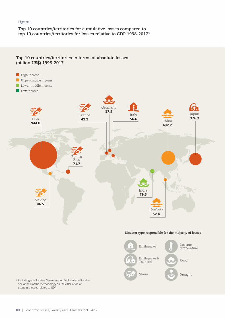
In absolute monetary terms, over the last 20-year, the USA recorded the biggest losses (US$ 945 billion), reflecting high asset values as well as frequent events (Figure 1). China, by comparison, suffered a significantly higher number of disasters than the USA (577 against 482), but lower total losses (US$ 492 billion).
Such losses are only part of the story, since the majority of disaster reports to EM-DAT (63%) contains no economic data. The World Bank has calculated that the real cost to the global economy is a staggering US$ 520 billion per annum, with disasters pushing 26 million people into poverty every year2.
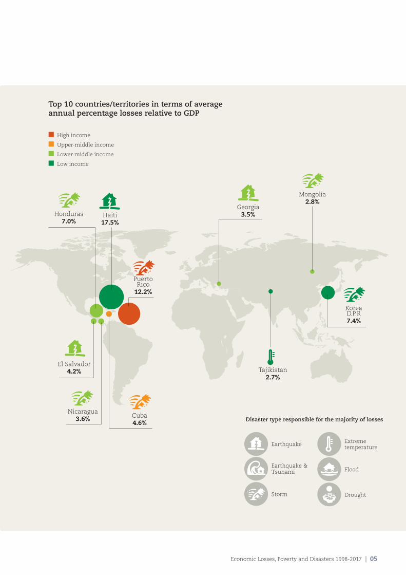
Absolute losses also mask the relatively greater burden of disasters on the poor. When economic costs are expressed as an average percentage of Gross Domestic Product (GDP), this becomes clearer. Figure 1 shows that only one high income territory ranked among the top 10 in terms of percentage of GDP losses over the past 20 years (Puerto Rico). Apart from upper-middle income Cuba, the other worst-hit nations were all lower income countries, led by Haiti.
Again, inequality is even greater than available losses data suggest because of systematic under-reporting by low income countries. While high income countries reported losses from 53% of disasters between 1998 and 2017, low income countries only reported them from 13% of disasters. No losses data are therefore available for nearly 87% of disasters in low income countries.
A similar divergence in record-keeping is evident geogra-phically. Oceania recorded losses for 51% of climate-related disasters in 1998-2017; in Africa, the figure is just 14%. Thus the economic statistics in this report are the tip of the iceberg as far as low income countries are concerned.
UNISDR and its partners are currently working with governments to establish robust national disaster loss databases as part of the Sendai Framework for Disaster Risk Reduction 2015-2030. Better record-keeping and standardized loss indicators will help planners improve how they manage “the risk of small-scale and large-scale, frequent and infrequent, sudden and slow-onset disasters caused by natural or man-made hazards.”
CRED, meanwhile, is employing an analytical technique known as georeferencing to drill down into EM-DAT data to reveal the relative vulnerabilities of rich and poor, and quantify how the human cost of disasters increases relentlessly in cases where national income levels decline.
For disasters since 2000, georeferencing has found that in low income countries, an average of 130 people died per million living in disaster-affected areas, compared to just 18 in high income countries. That means people exposed to natural hazards in the poorest nations were more than seven times more likely to die than equivalent populations in the richest nations.
A similar pattern of deep inequality is revealed by georeferenced ratios of people affected (but not killed) by disasters. While the largest absolute numbers of people affected by disasters lived in upper-middle income countries, by far the highest number per 100 inhabitants lived in low income countries. Again the contrast is sharpest between low income countries (7.8%) and high income countries (1.3%), meaning that people in the poorest countries were on average six times more likely than people in rich nations to be injured, to lose their home, be displaced or evacuated, or require emergency assistance.
Such data demonstrate that while absolute economic losses might be concentrated in high income countries, the human cost of disasters falls overwhelmingly on low and lower-middle income countries: vulnerability to risk, and degrees of suffering, are determined by levels of economic development, rather than simple exposure to natural hazards per se.
At a time when climate change is increasing the frequency and severity of extreme weather events, disasters will continue to be major impediments to sustainable development so long as the economic incentives to develop in hazard-prone locations such as flood plains, vulnerable coasts and earthquake zones continue to outweigh the perceived disaster risks.
Integrating disaster risk reduction into investment decisions is the most cost-effective way to reduce these risks; investing in disaster risk reduction is therefore a precondition for developing sustainably in a changing climate.
1 All economic losses and GDP are adjusted at 2017 US$ value2 The World Bank - Results Brief - Climate Insurance (2017) Available at :
https://www.worldbank.org/en/results/2017/12/01/climate-insurance
04 | Economic Losses, Poverty and Disasters 1998-2017
Top 10 countries/territories in terms of absolute losses (billion US$) 1998-2017
n High income
n Upper-middle income
n Lower-middle income
n Low income
Figure 1
Top 10 countries/territories for cumulative losses compared to top 10 countries/territories for losses relative to GDP 1998-20173
3 Excluding small states. See Annex for the list of small states. See Annex for the methodology on the calculation of economic losses related to GDP
USA 944.8
Mexico 46.5
PuertoRico 71.7
Italy 56.6
France 43.3
Germany 57.9
India 79.5
Thailand 52.4
China492.2
Japan376.3
Earthquake
Earthquake &Tsunami
Storm
Extreme temperature
Flood
Drought
Disaster type responsible for the majority of losses
Economic Losses, Poverty and Disasters 1998-2017 | 05
Top 10 countries/territories in terms of average annual percentage losses relative to GDP
n High income
n Upper-middle income
n Lower-middle income
n Low income
Earthquake
Earthquake &Tsunami
Storm
Extreme temperature
Flood
Drought
Disaster type responsible for the majority of losses
Korea D.P.R 7.4%
Georgia 3.5%Haiti
17.5%
PuertoRico
12.2%
Honduras 7.0%
Cuba 4.6%
Nicaragua 3.6%
El Salvador 4.2%
Mongolia 2.8%
Tajikistan 2.7%
Chapter 1
Disaster trends 1998-2017 Information about the occurrence and severity of disasters has greatly improved over recent decades, with an upswing in data reported to CRED in the past five years, encouraged perhaps by increasing international cooperation on disaster risk reduction, a growing number of national disaster loss databases, and efforts to accelerate implementation of the Sendai Framework.
When interpreting disaster data, one must be aware of the complex interactions between natural hazards and human vulnerabilities: the most violent storm over an uninhabited region will not be a disaster if no people are harmed, while even a small tsunami hitting a populous city with no early warning system can quickly become a major disaster. Continued variability in reporting and recording must also be taken into account, particularly when looking for trends and patterns within the numbers.
06 | Economic Losses, Poverty and Disasters 1998-2017
Economic Losses, Poverty and Disasters 1998-2017 | 07
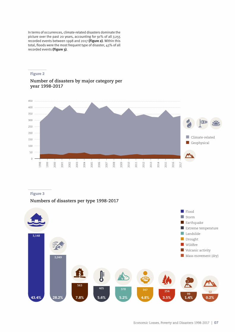
In terms of occurrences, climate-related disasters dominate the picture over the past 20 years, accounting for 91% of all 7,255 recorded events between 1998 and 2017 (Figure 2). Within this total, floods were the most frequent type of disaster, 43% of all recorded events (Figure 3).
Figure 2
Number of disasters by major category per year 1998-2017
Figure 3
Numbers of disasters per type 1998-2017
43.4% 28.2% 7.8% 5.6% 5.2% 4.8% 3.5% 1.4% 0.2%
3,148
2,049
563405 378 347 254
9912
n Flood
n Storm
n Earthquake
n Extreme temperature
n Landslide
n Drought
n Wildfire
n Volcanic activity
n Mass movement (dry)
n Climate-related
n Geophysical
450
400
350
300
250
200
150
100
50
0
1998
1999
2000
2001
2002
2003
2004
2005
2006
2007
2008
2009
2010
2011
2012
2013
2014
2015
2016
2017
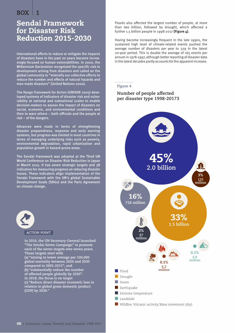
Floods also affected the largest number of people, at more than two billion, followed by drought, which affected a further 1.5 billion people in 1998-2017 (Figure 4).
Having become increasingly frequent in the late 1990s, the sustained high level of climate-related events pushed the average number of disasters per year to 329 in the latest 20-year period. This is double the average of 165 events per annum in 1978-1997, although better reporting of disaster data in the latest decades partly accounts for the apparent increase.
BOX 1
Sendai Framework for Disaster Risk Reduction 2015-2030
International efforts to reduce or mitigate the impacts of disasters have in the past 20 years become increa-singly focused on human vulnerabilities. In 2000, the Millennium Declaration recognized the specific risk to development arising from disasters and called on the global community to “intensify our collective efforts to reduce the number and effects of natural hazards and man-made disasters” (United Nations 2000).
The Hyogo Framework for Action (UNISDR 2005) deve-loped systems of indicators of disaster risk and vulne-rability at national and subnational scales to enable decision-makers to assess the impact of disasters on social, economic, and environmental conditions and then to warn others – both officials and the people at risk – of the dangers.
Advances were made in terms of strengthening disaster preparedness, response and early warning systems, but progress was limited in most countries in terms of managing underlying risks such as poverty, environmental degradation, rapid urbanization and population growth in hazard-prone areas.
The Sendai Framework was adopted at the Third UN World Conference on Disaster Risk Reduction in Japan in March 2015. It has seven strategic targets and 38 indicators for measuring progress on reducing disaster losses. These indicators align implementation of the Sendai Framework with the UN’s global Sustainable Development Goals (SDGs) and the Paris Agreement on climate change.
ACTION POINT
In 2016, the UN Secretary-General launched “The Sendai Seven Campaign” to promote each of the seven targets over seven years. These targets start with (a) “aiming to lower average per 100,000 global mortality between 2020 and 2030 compared to 2005-2015”, and (b) “substantially reduce the number of affected people globally by 2030”. In 2018, the focus is on target (c) “Reduce direct disaster economic loss in relation to global gross domestic product (GDP) by 2030.”
Figure 4
Number of people affected per disaster type 1998-20173
n Flood
n Drought
n Storm
n Earthquake
n Extreme temperature
n Landslide
n Wildfire, Volcanic activity, Mass movement (dry)
45%2.0 billion
33%1.5 billion
16%726 million
3%125
million
0.1%4.8
million0.1%6.2
million
2%97
million
08 | Economic Losses, Poverty and Disasters 1998-2017
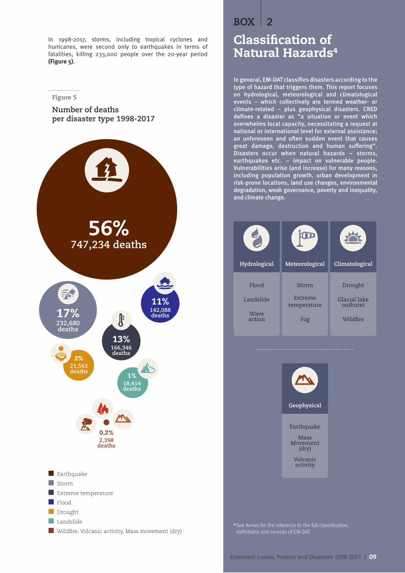
In 1998-2017, storms, including tropical cyclones and hurricanes, were second only to earthquakes in terms of fatalities, killing 233,000 people over the 20-year period (Figure 5).
BOX 2
Classification of Natural Hazards4
In general, EM-DAT classifies disasters according to the type of hazard that triggers them. This report focuses on hydrological, meteorological and climatological events – which collectively are termed weather- or climate-related – plus geophysical disasters. CRED defines a disaster as “a situation or event which overwhelms local capacity, necessitating a request at national or international level for external assistance; an unforeseen and often sudden event that causes great damage, destruction and human suffering”. Disasters occur when natural hazards – storms, earthquakes etc. – impact on vulnerable people. Vulnerabilities arise (and increase) for many reasons, including population growth, urban development in risk-prone locations, land use changes, environmental degradation, weak governance, poverty and inequality, and climate change.
n Earthquake
n Storm
n Extreme temperature
n Flood
n Drought
n Landslide
n Wildfire, Volcanic activity, Mass movement (dry)
Figure 5
Number of deaths per disaster type 1998-2017
Earthquake
Mass Movement
(dry)
Volcanic activity
Geophysical
Hydrological
Flood
Landslide
Wave action
Storm
Extreme temperature
Fog
Drought
Glacial lake outburst
Wildfire
Meteorological Climatological
56%747,234 deaths
13%166,346 deaths
17%232,680 deaths
11%142,088 deaths
2%21,563 deaths
1%18,414 deaths
0.2%2,398
deaths
Economic Losses, Poverty and Disasters 1998-2017 | 09
4 See Annex for the reference to the full classification, definitions and sources of EM-DAT
10 | Economic Losses, Poverty and Disasters 1998-2017
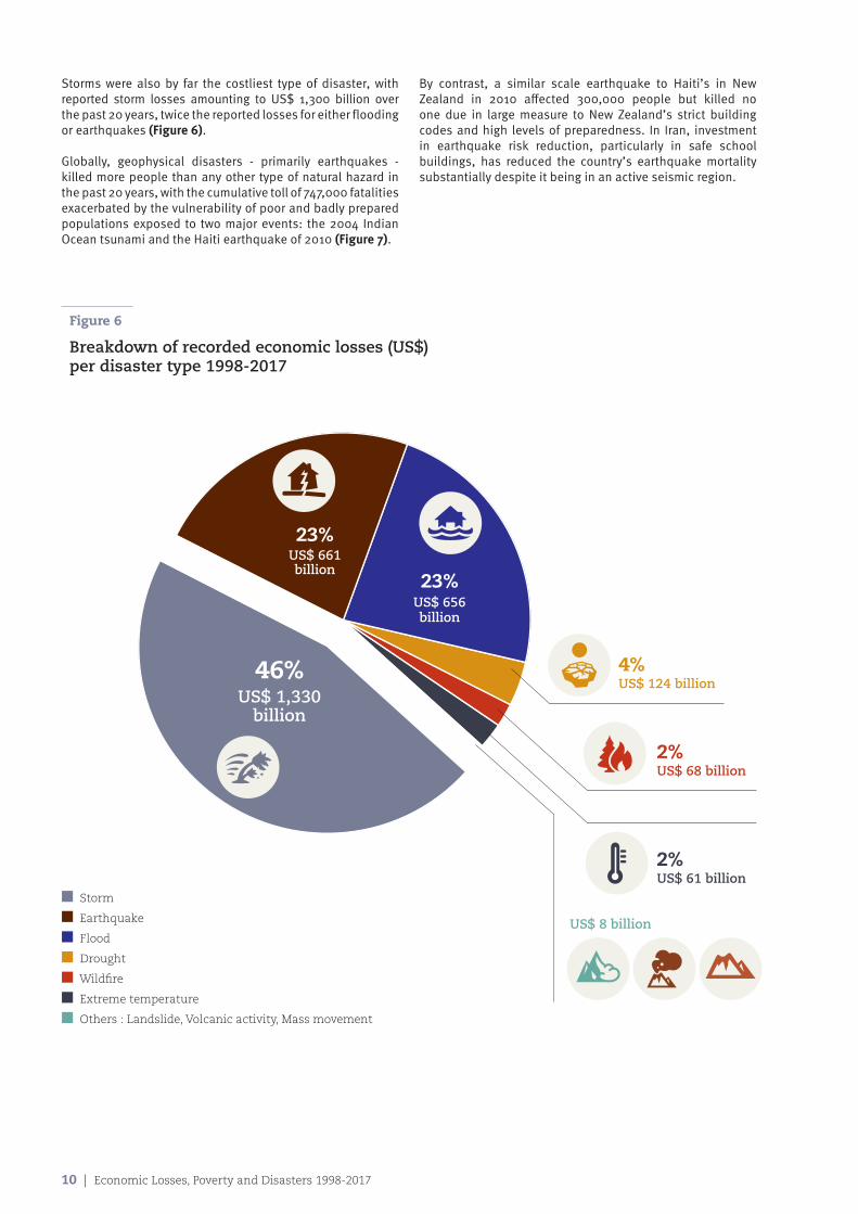
Storms were also by far the costliest type of disaster, with reported storm losses amounting to US$ 1,300 billion over the past 20 years, twice the reported losses for either flooding or earthquakes (Figure 6).
Globally, geophysical disasters - primarily earthquakes - killed more people than any other type of natural hazard in the past 20 years, with the cumulative toll of 747,000 fatalities exacerbated by the vulnerability of poor and badly prepared populations exposed to two major events: the 2004 Indian Ocean tsunami and the Haiti earthquake of 2010 (Figure 7).
By contrast, a similar scale earthquake to Haiti’s in New Zealand in 2010 affected 300,000 people but killed no one due in large measure to New Zealand’s strict building codes and high levels of preparedness. In Iran, investment in earthquake risk reduction, particularly in safe school buildings, has reduced the country’s earthquake mortality substantially despite it being in an active seismic region.
Figure 6
Breakdown of recorded economic losses (US$) per disaster type 1998-2017
n Storm
n Earthquake
n Flood
n Drought
n Wildfire
n Extreme temperature
n Others : Landslide, Volcanic activity, Mass movement
46%US$ 1,330
billion
23%US$ 661 billion
23%US$ 656 billion
4%US$ 124 billion$
2%US$ 68 billion
2%US$ 61 billion
US$ 8 billion
Economic Losses, Poverty and Disasters 1998-2017 | 11
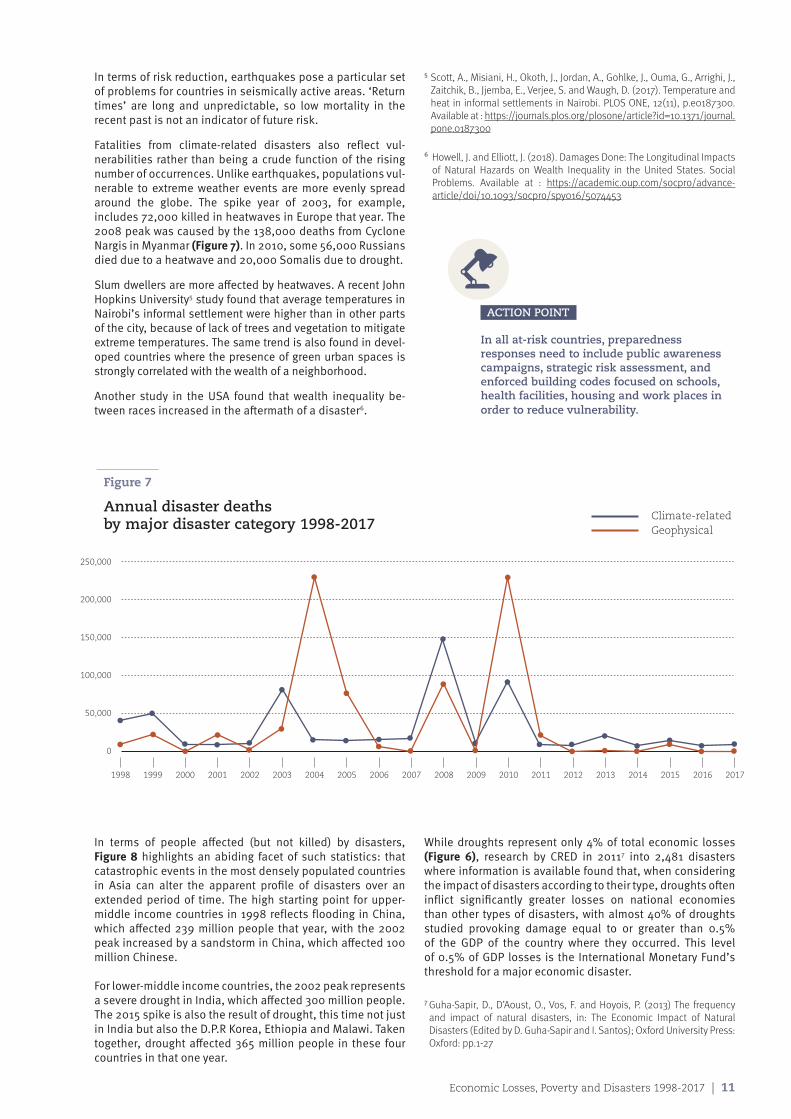
In terms of risk reduction, earthquakes pose a particular set of problems for countries in seismically active areas. ‘Return times’ are long and unpredictable, so low mortality in the recent past is not an indicator of future risk.
Fatalities from climate-related disasters also reflect vul-nerabilities rather than being a crude function of the rising number of occurrences. Unlike earthquakes, populations vul-nerable to extreme weather events are more evenly spread around the globe. The spike year of 2003, for example, includes 72,000 killed in heatwaves in Europe that year. The 2008 peak was caused by the 138,000 deaths from Cyclone Nargis in Myanmar (Figure 7). In 2010, some 56,000 Russians died due to a heatwave and 20,000 Somalis due to drought.
Slum dwellers are more affected by heatwaves. A recent John Hopkins University5 study found that average temperatures in Nairobi’s informal settlement were higher than in other parts of the city, because of lack of trees and vegetation to mitigate extreme temperatures. The same trend is also found in devel-oped countries where the presence of green urban spaces is strongly correlated with the wealth of a neighborhood.
Another study in the USA found that wealth inequality be-tween races increased in the aftermath of a disaster6.
5 Scott, A., Misiani, H., Okoth, J., Jordan, A., Gohlke, J., Ouma, G., Arrighi, J., Zaitchik, B., Jjemba, E., Verjee, S. and Waugh, D. (2017). Temperature and heat in informal settlements in Nairobi. PLOS ONE, 12(11), p.e0187300.Available at : https://journals.plos.org/plosone/article?id=10.1371/journal.pone.0187300
6 Howell, J. and Elliott, J. (2018). Damages Done: The Longitudinal Impacts of Natural Hazards on Wealth Inequality in the United States. Social Problems. Available at : https://academic.oup.com/socpro/advance-article/doi/10.1093/socpro/spy016/5074453
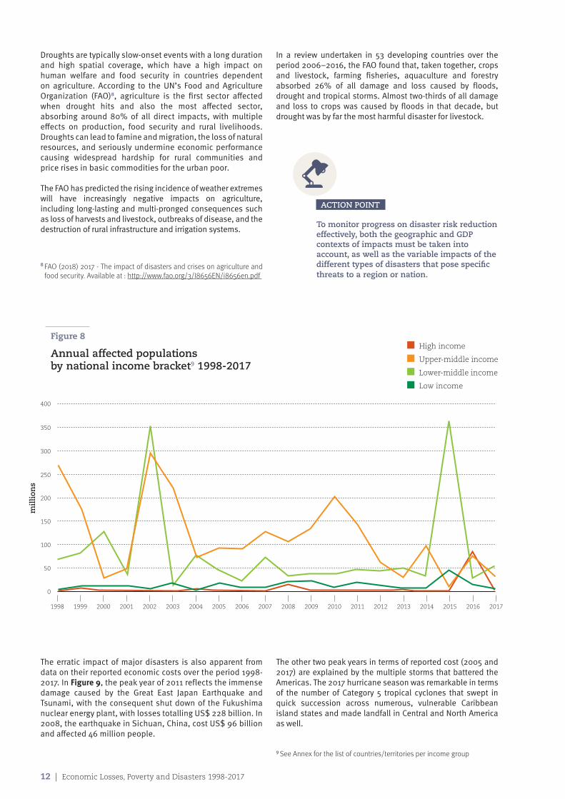
In terms of people affected (but not killed) by disasters, Figure 8 highlights an abiding facet of such statistics: that catastrophic events in the most densely populated countries in Asia can alter the apparent profile of disasters over an extended period of time. The high starting point for upper-middle income countries in 1998 reflects flooding in China, which affected 239 million people that year, with the 2002 peak increased by a sandstorm in China, which affected 100 million Chinese.
For lower-middle income countries, the 2002 peak represents a severe drought in India, which affected 300 million people. The 2015 spike is also the result of drought, this time not just in India but also the D.P.R Korea, Ethiopia and Malawi. Taken together, drought affected 365 million people in these four countries in that one year.
While droughts represent only 4% of total economic losses (Figure 6), research by CRED in 20117 into 2,481 disasters where information is available found that, when considering the impact of disasters according to their type, droughts often inflict significantly greater losses on national economies than other types of disasters, with almost 40% of droughts studied provoking damage equal to or greater than 0.5% of the GDP of the country where they occurred. This level of 0.5% of GDP losses is the International Monetary Fund’s threshold for a major economic disaster.
Figure 7
Annual disaster deaths by major disaster category 1998-2017
Climate-related Geophysical
1998 1999 2000 2001 2002 2003 2004 2005 2006 2007 2008 2009 2010 2011 2012 2013 2014 2015 2016 2017
0
50,000
100,000
150,000
200,000
250,000
ACTION POINT
In all at-risk countries, preparedness responses need to include public awareness campaigns, strategic risk assessment, and enforced building codes focused on schools, health facilities, housing and work places in order to reduce vulnerability.
7 Guha-Sapir, D., D’Aoust, O., Vos, F. and Hoyois, P. (2013) The frequency and impact of natural disasters, in: The Economic Impact of Natural Disasters (Edited by D. Guha-Sapir and I. Santos); Oxford University Press: Oxford: pp.1-27
12 | Economic Losses, Poverty and Disasters 1998-2017
Droughts are typically slow-onset events with a long duration and high spatial coverage, which have a high impact on human welfare and food security in countries dependent on agriculture. According to the UN’s Food and Agriculture Organization (FAO)8, agriculture is the first sector affected when drought hits and also the most affected sector, absorbing around 80% of all direct impacts, with multiple effects on production, food security and rural livelihoods. Droughts can lead to famine and migration, the loss of natural resources, and seriously undermine economic performance causing widespread hardship for rural communities and price rises in basic commodities for the urban poor.
The FAO has predicted the rising incidence of weather extremes will have increasingly negative impacts on agriculture, including long-lasting and multi-pronged consequences such as loss of harvests and livestock, outbreaks of disease, and the destruction of rural infrastructure and irrigation systems.
In a review undertaken in 53 developing countries over the period 2006–2016, the FAO found that, taken together, crops and livestock, farming fisheries, aquaculture and forestry absorbed 26% of all damage and loss caused by floods, drought and tropical storms. Almost two-thirds of all damage and loss to crops was caused by floods in that decade, but drought was by far the most harmful disaster for livestock.
n High income
n Upper-middle income
n Lower-middle income
n Low income
1998 1999 2000 2001 2002 2003 2004 2005 2006 2007 2008 2009 2010 2011 2012 2013 2014 2015 2016 2017
0
50
100
150
200
250
300
350
400
Figure 8
Annual affected populations by national income bracket9 1998-2017
8 FAO (2018) 2017 - The impact of disasters and crises on agriculture and food security. Available at : http://www.fao.org/3/I8656EN/i8656en.pdf
ACTION POINT
To monitor progress on disaster risk reduction effectively, both the geographic and GDP contexts of impacts must be taken into account, as well as the variable impacts of the different types of disasters that pose specific threats to a region or nation.
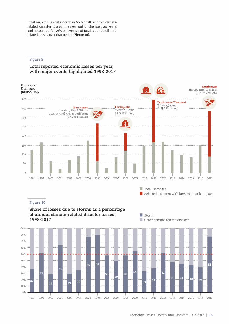
The erratic impact of major disasters is also apparent from data on their reported economic costs over the period 1998-2017. In Figure 9, the peak year of 2011 reflects the immense damage caused by the Great East Japan Earthquake and Tsunami, with the consequent shut down of the Fukushima nuclear energy plant, with losses totalling US$ 228 billion. In 2008, the earthquake in Sichuan, China, cost US$ 96 billion and affected 46 million people.
The other two peak years in terms of reported cost (2005 and 2017) are explained by the multiple storms that battered the Americas. The 2017 hurricane season was remarkable in terms of the number of Category 5 tropical cyclones that swept in quick succession across numerous, vulnerable Caribbean island states and made landfall in Central and North America as well.
9 See Annex for the list of countries/territories per income group
mil
lion
s
Economic Losses, Poverty and Disasters 1998-2017 | 13
Together, storms cost more than 60% of all reported climate-related disaster losses in seven out of the past 20 years, and accounted for 59% on average of total reported climate-related losses over that period (Figure 10).
Figure 9
Total reported economic losses per year, with major events highlighted 1998-2017
Figure 10
Share of losses due to storms as a percentage of annual climate-related disaster losses 1998-2017
1998 1999 2000 2001 2002 2003 2004 2005 2006 2007 2008 2009 2010 2011 2012 2013 2014 2015 2016 2017
0%
40%
20%
60%
10%
50%
30%
70%
80%
90%
100%
37
61
28
74
2935
86 89
5850
5864
33 38
62
47 44 43 39
88
n Total Damages
n Selected disasters with large economic impact
n Storm
n Other climate-related disaster
1998 1999 2000 2001 2002 2003 2004 2005 2006 2007 2008 2009 2010 2011 2012 2013 2014 2015 2016 2017
0
200
100
300
50
250
150
350
400
HurricanesKatrina, Rita & Wilma
USA, Central Am. & Caribbean(US$ 201 billion)
EarthquakeSichuan, China(US$ 96 billion)
Earthquake/TsunamiTohoku, Japan(US$ 228 billion)
HurricanesHarvey, Irma & Maria
(US$ 245 billion)
EconomicDamages(billion US$)
Chapter 2
Economic patterns in disasters data The direct economic costs of disasters have been systematically under-reported worldwide for decades, both in wealthier countries and, most especially, in poorer ones. Throughout the period 1998-2017, economic losses data only exist for 37% of disasters; the direct cost of the majority of disasters (63%) is unknown or not well documented.
14 | Economic Losses, Poverty and Disasters 1998-2017
Economic Losses, Poverty and Disasters 1998-2017 | 15
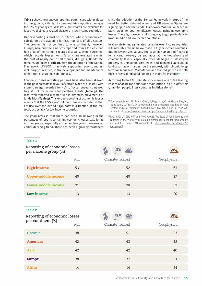
Table 1 shows how uneven reporting patterns are within global income groups, with high income countries reporting damages for 61% of geophysical disasters, but records are available for just 13% of climate-related disasters in low income countries.
Under-reporting is most acute in Africa, where economic cost calculations are available for less than 14% of all disasters. The problem is not confined to one continent, however. Europe, Asia and the Americas reported losses for less than half of all of their climate-related disasters. Even in Oceania, which records losses for 51% of climate-related events, the cost of nearly half of all storms, droughts, floods etc. remains unknown (Table 2). With the adoption of the Sendai Framework, UNISDR is actively supporting 100 countries, including 30 in Africa, in the development and maintenance of national disaster loss databases.
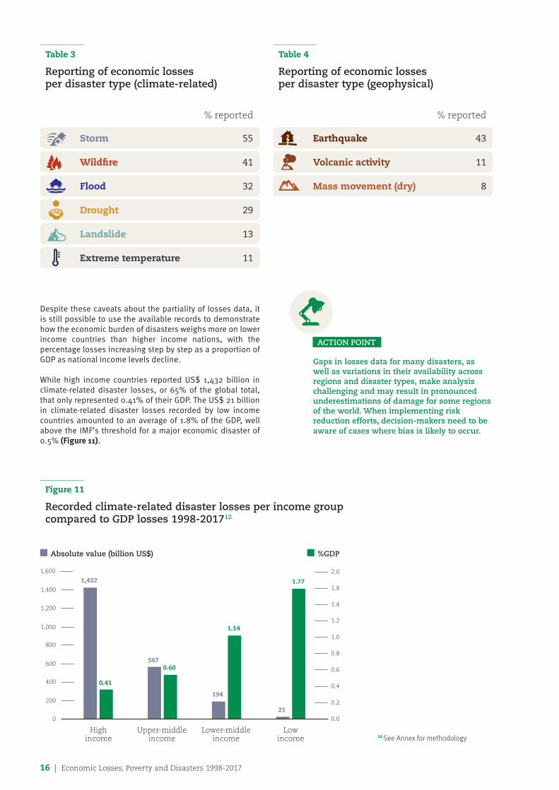
Economic losses reporting patterns have also been skewed in the past 20 years in favour of certain types of disaster, with storm damage recorded for 55% of occurrences, compared to just 11% for extreme temperature events (Table 3). The least well reported disaster type is dry mass movements or landslides (Table 4). This under-reporting of economic losses means that the US$ 2,908 billion of losses recorded within EM-DAT over the period 1998-2017 is a fraction of the real total, especially for low income countries.
The good news is that there has been an upswing in the percentage of reports containing economic losses data for all income groups, especially in the last five years, reversing an earlier declining trend. There has been a growing awareness
since the adoption of the Sendai Framework in 2015 of the need for better data collection and UN Member States are signing up to use the Sendai Framework Monitor, launched in March 2018, to report on disaster losses, including economic losses. There is, however, still a long way to go, particularly in lower-middle and low income countries.
In absolute terms, aggregated losses in lower income countries will inevitably remain below those in higher income countries, due to lower asset values. The costs in human and financial terms can, however, be enormous at the household and community levels, especially when damaged or destroyed property is uninsured. Lost crops and damaged agricultural land also impact hardest on the poorest, with chronic long-term consequences. Malnutrition and stunted growth are both high in areas of repeated flooding in India, for instance10.
According to the FAO, climate shocks were one of the leading causes of acute food crisis and malnutrition in 2017, affecting 59 million people in 24 countries in Africa alone11.
Table 1
Reporting of economic losses per income group (%) ALL Climate-related Geophysical
High income 53 52 61
Upper-middle income 40 40 37
Lower-middle income 31 30 31
Low income 13 13 20
Table 2
Reporting of economic losses per continent (%) ALL Climate-related Geophysical
Oceania 48 51 23
Americas 42 43 32
Asia 42 42 40
Europe 38 37 54
Africa 14 14 24
10 Rodriguez-Llanes, J.M., Ranjan-Dash, S., Degomme, O., Mukhopadhyay, A., Guha-Sapir, D. (2011). Child malnutrition and recurrent flooding in rural eastern India: a community-based survey. BMJ Open 2001;1: e000109. Available at : https://www.ncbi.nlm.nih.gov/pmc/articles/PMC3208901/
11 FAO, IFAD, UNICEF, WFP and WHO. (2018). The State of Food Security and Nutrition in the World 2018. Building climate resilience for food security and nutrition. Rome, FAO. Available at : http://www.fao.org/3/I9553EN/i9553en.pdf
16 | Economic Losses, Poverty and Disasters 1998-2017
Table 4
Reporting of economic losses per disaster type (geophysical)
% reported
Earthquake 43
Volcanic activity 11
Mass movement (dry) 8
Table 3
Reporting of economic losses per disaster type (climate-related)
% reported
Storm 55
Wildfire 41
Flood 32
Drought 29
Landslide 13
Extreme temperature 11
ACTION POINT
Gaps in losses data for many disasters, as well as variations in their availability across regions and disaster types, make analysis challenging and may result in pronounced underestimations of damage for some regions of the world. When implementing risk reduction efforts, decision-makers need to be aware of cases where bias is likely to occur.
Despite these caveats about the partiality of losses data, it is still possible to use the available records to demonstrate how the economic burden of disasters weighs more on lower income countries than higher income nations, with the percentage losses increasing step by step as a proportion of GDP as national income levels decline.
While high income countries reported US$ 1,432 billion in climate-related disaster losses, or 65% of the global total, that only represented 0.41% of their GDP. The US$ 21 billion in climate-related disaster losses recorded by low income countries amounted to an average of 1.8% of the GDP, well above the IMF’s threshold for a major economic disaster of 0.5% (Figure 11).
Figure 11
Recorded climate-related disaster losses per income group compared to GDP losses 1998-201712
1,400
1,600
1,200
1,000
800
600
400
200
0.0
0.2
0.4
0.6
0.8
1.0
1.2
1.4
2.0
1.8
0
Highincome
Upper-middle income
Lower-middle income
Lowincome
n Absolute value (billion US$) n %GDP
1,432
0.41
5670.60
194
1.14
21
1.77
12 See Annex for methodology
Economic Losses, Poverty and Disasters 1998-2017 | 17
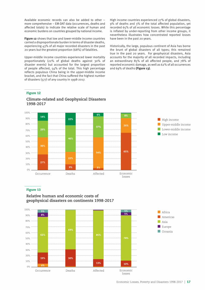
Available economic records can also be added to other – more comprehensive – EM-DAT data (occurrences, deaths and affected totals) to indicate the relative scale of human and economic burdens on countries grouped by national income. Figure 12 shows that low and lower-middle income countries carried a disproportionate burden in terms of disaster deaths, experiencing 43% of all major recorded disasters in the past 20 years but the greatest proportion (68%) of fatalities.
Upper-middle income countries experienced lower mortality proportionately (22% of global deaths against 30% of disaster events) but accounted for the largest proportion of people affected, 54% of the total. This high percentage reflects populous China being in the upper-middle income bracket, and the fact that China suffered the highest number of disasters (577) of any country in 1998-2017.
High income countries experienced 27% of global disasters, 9% of deaths and 3% of the total affected population, yet recorded 65% of all economic losses. While this percentage is inflated by under-reporting from other income groups, it nevertheless illustrates how concentrated reported losses have been in the past 20 years.
Historically, the large, populous continent of Asia has borne the brunt of global disasters of all types; this remained true in the past 20 years. For geophysical disasters, Asia accounts for the majority of all recorded impacts, including an extraordinary 85% of all affected people, and 78% of reported economic damage, as well as 62% of all occurrences and 69% of deaths (Figure 13).
Figure 12
Climate-related and Geophysical Disasters 1998-2017
Figure 13
Relative human and economic costs of geophysical disasters on continents 1998-2017
n High income
n Upper-middle income
n Lower-middle income
n Low income
n Africa
n Americas
n Asia
n Europe
n Oceania
0%
40%
20%
60%
10%
50%
30%
70%
80%
90%
100%
Occurrence Deaths Affected Economiclosses
14%22%
6% 8%
26%
65%
37%
54%
3%
46%
22%
9%
30%
27%
29%
0%
40%
20%
60%
10%
50%
30%
70%
80%
90%
100%
Occurrence Deaths Affected Economiclosses
5%8%
6%
19%
10%
5%5%
85%
69%
62%78%
30%
13%
18 | Economic Losses, Poverty and Disasters 1998-2017
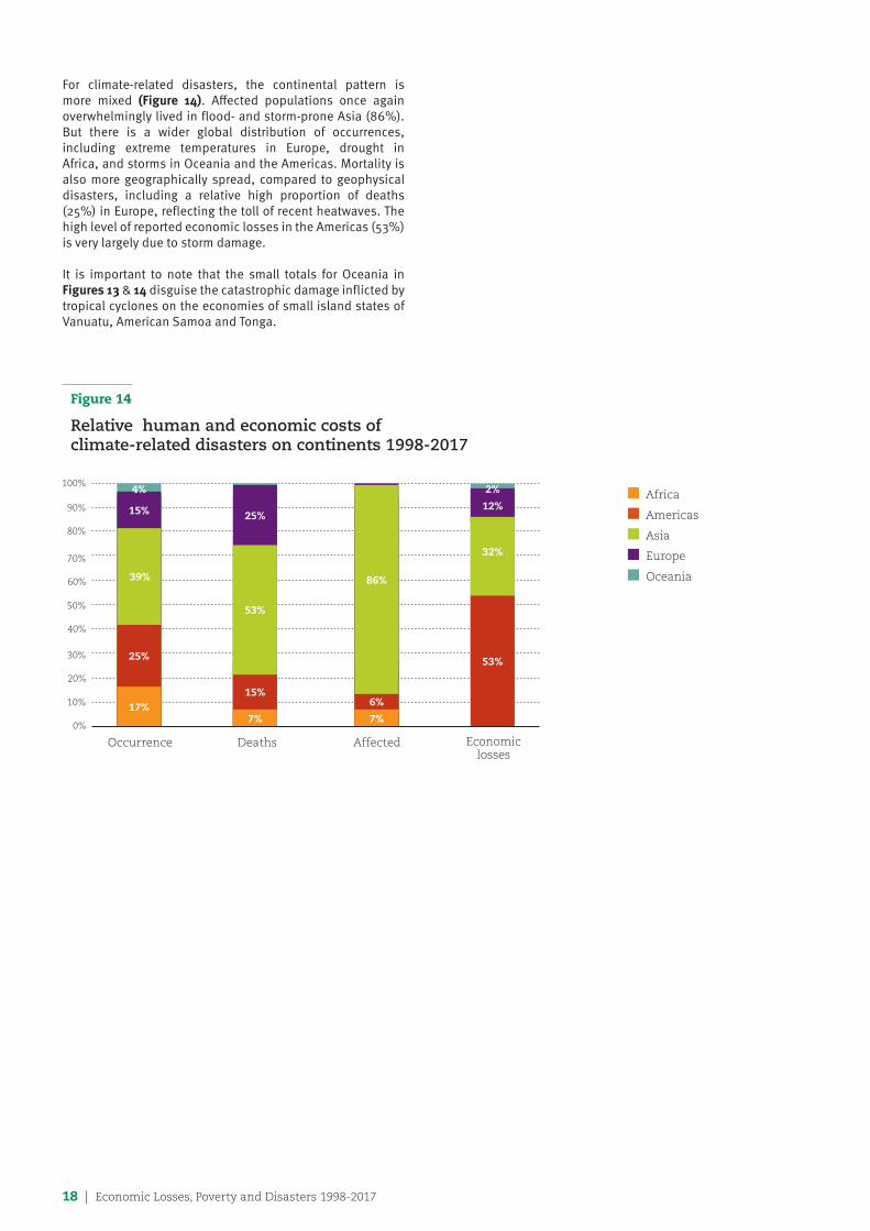
For climate-related disasters, the continental pattern is more mixed (Figure 14). Affected populations once again overwhelmingly lived in flood- and storm-prone Asia (86%). But there is a wider global distribution of occurrences, including extreme temperatures in Europe, drought in Africa, and storms in Oceania and the Americas. Mortality is also more geographically spread, compared to geophysical disasters, including a relative high proportion of deaths (25%) in Europe, reflecting the toll of recent heatwaves. The high level of reported economic losses in the Americas (53%) is very largely due to storm damage.
It is important to note that the small totals for Oceania in Figures 13 & 14 disguise the catastrophic damage inflicted by tropical cyclones on the economies of small island states of Vanuatu, American Samoa and Tonga.
Figure 14
Relative human and economic costs of climate-related disasters on continents 1998-2017
n Africa
n Americas
n Asia
n Europe
n Oceania
0%
40%
20%
60%
10%
50%
30%
70%
80%
90%
100%
Occurrence Deaths Affected Economiclosses
25%
7%
15%
53%
7%
6%
86%
53%
2%
12%
4%
15%
17%
25%
39%
32%
Economic Losses, Poverty and Disasters 1998-2017 | 19
Chapter 3
Human cost of disasters 1998-2017 In EM-DAT, the human cost of disasters is measured by two main parameters: the number of people killed, missing or presumed dead, and the number of people affected by the events, that is, in need of immediate assistance for basic survival needs (food, water, shelter, sanitation, medical assistance). The affected totals also include people injured, made homeless, displaced or evacuated during the emergency phase of a disaster.
Raw numbers like these can, however, mask the reality of the relative burden of disasters on different populations, and make valid comparisons difficult. CRED, therefore, also examines EM-DAT data by standardized measurements (per million inhabitants and percentages, for example) to demonstrate the proportion of vulnerable populations killed or affected by disasters worldwide13.
This report adds a further layer of analysis: georeferencing, a technique that increases the precision of data by identifying the population potentially exposed (PPE) to actual disasters using the FAO’s Global Administrative Units Layers (GAUL).
13 See Annex for methodology
20 | Economic Losses, Poverty and Disasters 1998-2017
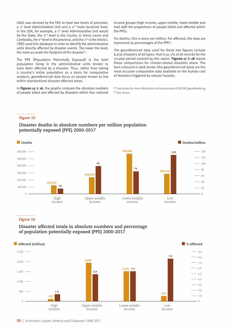
GAUL was devised by the FAO to have two levels of precision: a 1st level Administrative Unit and a 2nd more localized level. In the USA, for example, a 1st level Administrative Unit would be the State, the 2nd level is the County. In Sierra Leone and Cambodia, the 1st level is the province, and the 2nd is the district. CRED used this database in order to identify the administrative units directly affected by disaster events. The lower the level, the more accurate the footprint of the disaster14.
The PPE (Population Potentially Exposed) is the total population living in the administrative units known to have been affected by a disaster. Thus, rather than taking a country’s entire population as a basis for comparative analysis, georeferenced data focus on people known to live within standardized disaster-affected areas.
In Figures 15 & 16, the graphs compare the absolute numbers of people killed and affected by disasters within four national
income groups (high income, upper-middle, lower-middle and low) with the proportions of people killed and affected within the PPEs.
For deaths, this is done per million. For affected, the data are expressed as percentages of the PPE15.
The georeferenced data used for these two figures include 6,636 disasters of all types: that is 91.5% of all records for the 20-year period covered by this report. Figures 17 & 18 repeat these comparisons for climate-related disasters alone. The bars coloured in dark brown (the georeferenced data) are the most accurate comparative data available on the human cost of disasters triggered by natural hazards.
14 See Annex for more information on the precision of EM-DAT georeferencing15 See Annex
Figure 15
Disaster deaths in absolute numbers per million population potentially exposed (PPE) 2000-2017
600,000
500,000
400,000
300,000
200,000
100,000
0
20
40
60
80
100
120
140
0
Highincome
Upper-middle income
Lower-middle income
Lowincome
n Deaths n Deaths/million
120,33918
236,078
92
569,042
75285,136
130
Figure 16
Disaster affected totals in absolute numbers and percentage of population potentially exposed (PPE) 2000-2017
2,500
2,000
1,500
1,000
500
0
1.0
4.0
2.0
6.0
7.0
9.0
8.0
0
Highincome
Upper-middle income
Lower-middle income
Lowincome
n Affected (million) n % Affected
129
1.3
1,945
4.91,527 5.5
270
7.8
3.0
5.0
Economic Losses, Poverty and Disasters 1998-2017 | 21
Georeferenced disasters 2000-2017
In absolute terms, lower-middle income countries suffered the highest number of deaths due to disasters over the past 18 years, with almost 570,000 people killed, the majority in geophysical events. By contrast, analysis of deaths per million PPE illustrates a clear global pattern, with death rates tending to increase as income levels decline (Figure 15).
In low income countries, an average of 130 people died per million PPE (i.e. those living in the immediate disaster zone) compared with just 18 in high income countries. That means people exposed to disasters in the poorest nations were more than seven times more likely to die than people in the richest nations.
A similar pattern of inequality is revealed by EM-DAT data on the proportion of people directly affected (but not killed) by disasters (Figure 16). While the largest absolute numbers lived in upper-middle income countries (almost two billion), by far the highest percentage of people directly affected per PPE lived in low income countries.
Again the contrast is sharpest between low income countries, where 7.8% of the PPE were on average directly affected by each disaster, against just 1.3% in high income countries. Thus, people in the poorest countries were on average six times more likely than people in rich nations to be injured, or lose their home, be displaced or evacuated, or require immediate medical assistance, food or shelter, and suffer the consequences of damage to critical infrastructure including the loss of public utilities, damaged schools, health facilities and places of employment.
Figure 16 also shows the stepped increase in affected numbers per PPE as income levels decline, from 1.3% (high income), 4.9% (upper-middle income), 5.5% (lower-middle income) to 7.8% (low income).
Broadly similar patterns are evident when analysing climate-related disasters alone.
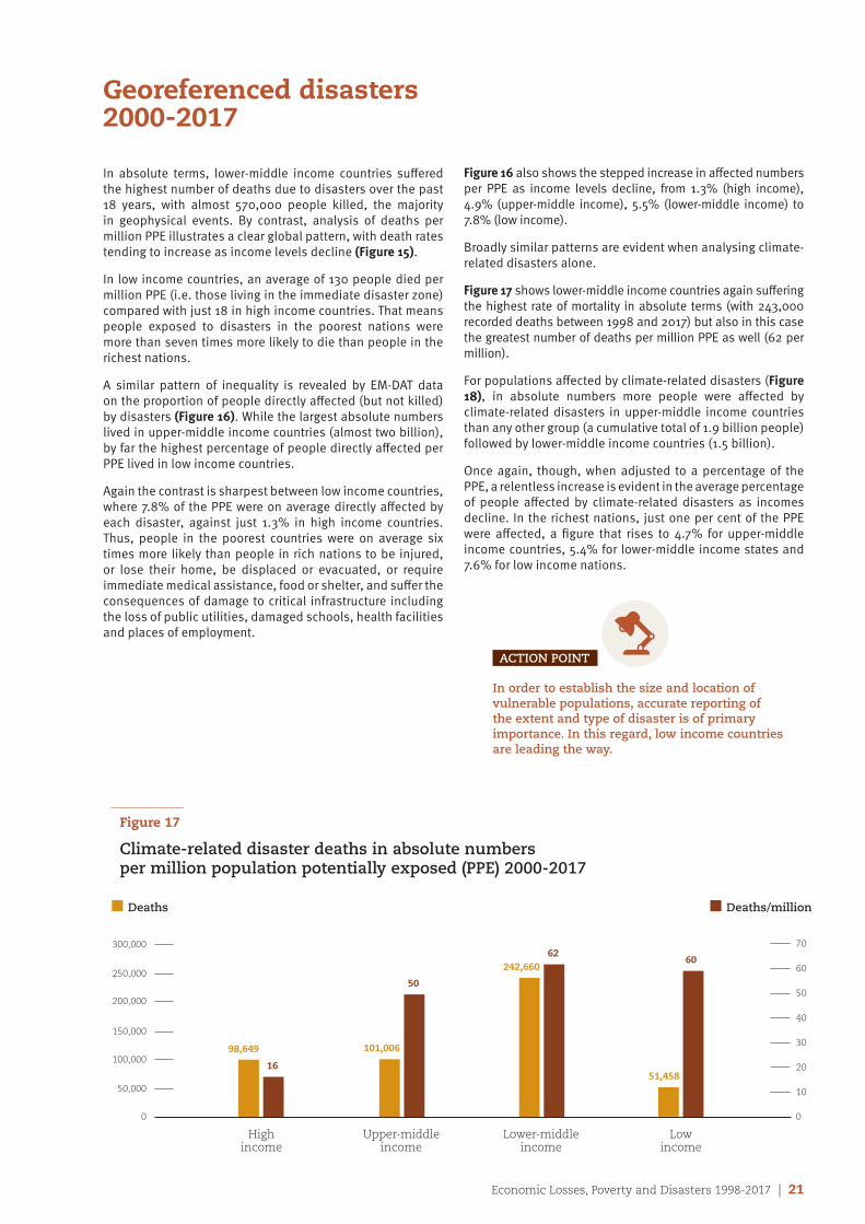
Figure 17 shows lower-middle income countries again suffering the highest rate of mortality in absolute terms (with 243,000 recorded deaths between 1998 and 2017) but also in this case the greatest number of deaths per million PPE as well (62 per million).
For populations affected by climate-related disasters (Figure 18), in absolute numbers more people were affected by climate-related disasters in upper-middle income countries than any other group (a cumulative total of 1.9 billion people) followed by lower-middle income countries (1.5 billion).
Once again, though, when adjusted to a percentage of the PPE, a relentless increase is evident in the average percentage of people affected by climate-related disasters as incomes decline. In the richest nations, just one per cent of the PPE were affected, a figure that rises to 4.7% for upper-middle income countries, 5.4% for lower-middle income states and 7.6% for low income nations.
ACTION POINT
In order to establish the size and location of vulnerable populations, accurate reporting of the extent and type of disaster is of primary importance. In this regard, low income countries are leading the way.
Figure 17
Climate-related disaster deaths in absolute numbers per million population potentially exposed (PPE) 2000-2017
300,000
250,000
200,000
150,000
100,000
50,000
0
10
20
30
40
50
60
70
0
Highincome
Upper-middle income
Lower-middle income
Lowincome
n Deaths n Deaths/million
98,649
16
101,006
50
242,66062
51,458
60
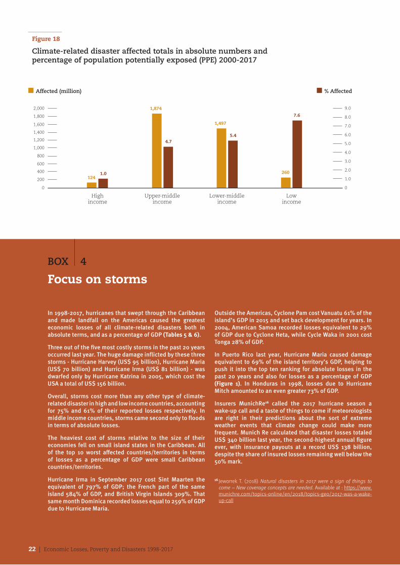
Figure 18
Climate-related disaster affected totals in absolute numbers and percentage of population potentially exposed (PPE) 2000-2017
1,200
1,400
1,600
1,800
2,000
1,000
800
600
400
200
0
1.0
2.0
3.0
4.0
5.0
6.0
7.0
8.0
9.0
0
Highincome
Upper-middle income
Lower-middle income
Lowincome
n Affected (million) n % Affected
1241.0
1,874
4.7
1,497
5.4
260
7.6
BOX 4
Focus on storms
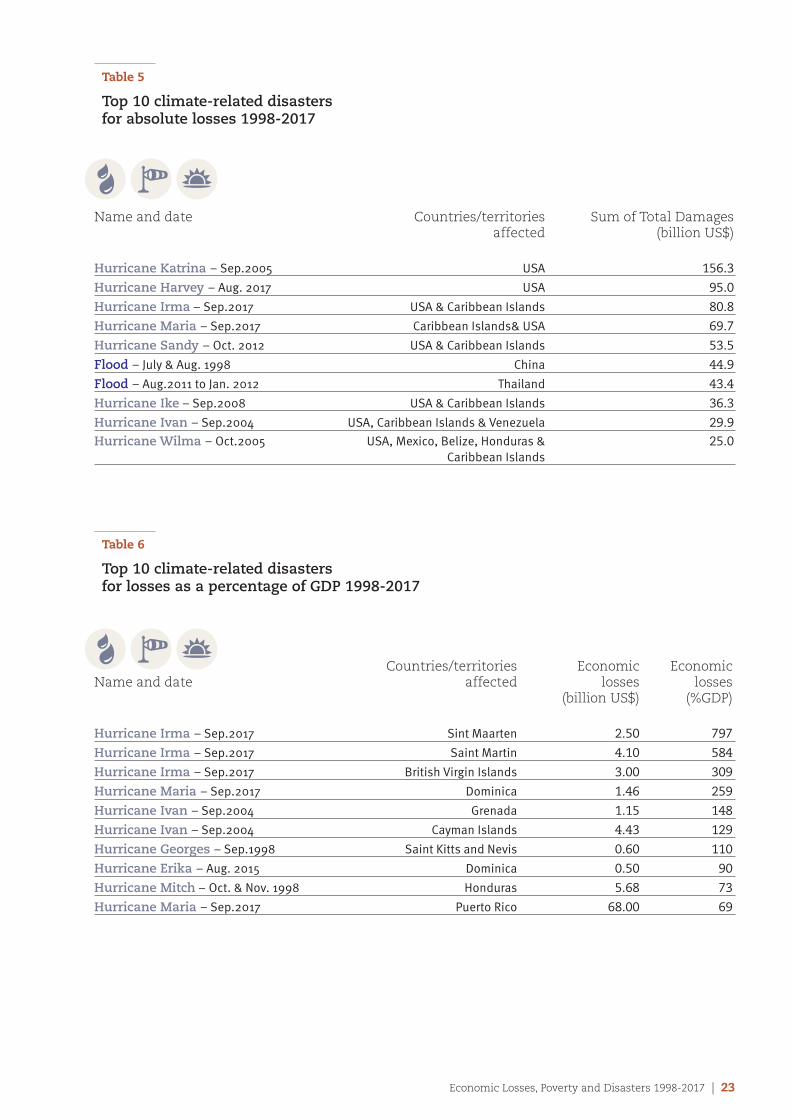
In 1998-2017, hurricanes that swept through the Caribbean and made landfall on the Americas caused the greatest economic losses of all climate-related disasters both in absolute terms, and as a percentage of GDP (Tables 5 & 6).
Three out of the five most costly storms in the past 20 years occurred last year. The huge damage inflicted by these three storms - Hurricane Harvey (US$ 95 billion), Hurricane Maria (US$ 70 billion) and Hurricane Irma (US$ 81 billion) - was dwarfed only by Hurricane Katrina in 2005, which cost the USA a total of US$ 156 billion.
Overall, storms cost more than any other type of climate-related disaster in high and low income countries, accounting for 75% and 61% of their reported losses respectively. In middle income countries, storms came second only to floods in terms of absolute losses.
The heaviest cost of storms relative to the size of their economies fell on small island states in the Caribbean. All of the top 10 worst affected countries/territories in terms of losses as a percentage of GDP were small Caribbean countries/territories.
Hurricane Irma in September 2017 cost Sint Maarten the equivalent of 797% of GDP; the French part of the same island 584% of GDP, and British Virgin Islands 309%. That same month Dominica recorded losses equal to 259% of GDP due to Hurricane Maria.
Outside the Americas, Cyclone Pam cost Vanuatu 61% of the island’s GDP in 2015 and set back development for years. In 2004, American Samoa recorded losses equivalent to 29% of GDP due to Cyclone Heta, while Cycle Waka in 2001 cost Tonga 28% of GDP.
In Puerto Rico last year, Hurricane Maria caused damage equivalent to 69% of the island territory’s GDP, helping to push it into the top ten ranking for absolute losses in the past 20 years and also for losses as a percentage of GDP (Figure 1). In Honduras in 1998, losses due to Hurricane Mitch amounted to an even greater 73% of GDP.
Insurers MunichRe16 called the 2017 hurricane season a wake-up call and a taste of things to come if meteorologists are right in their predictions about the sort of extreme weather events that climate change could make more frequent. Munich Re calculated that disaster losses totaled US$ 340 billion last year, the second-highest annual figure ever, with insurance payouts at a record US$ 138 billion, despite the share of insured losses remaining well below the 50% mark.
16 Jeworrek T. (2018) Natural disasters in 2017 were a sign of things to come – New coverage concepts are needed. Available at : https://www.munichre.com/topics-online/en/2018/topics-geo/2017-was-a-wake-up-call
22 | Economic Losses, Poverty and Disasters 1998-2017
Economic Losses, Poverty and Disasters 1998-2017 | 23
Table 5
Top 10 climate-related disasters for absolute losses 1998-2017
Name and date Countries/territories Sum of Total Damages affected (billion US$)
Hurricane Katrina – Sep.2005 USA 156.3
Hurricane Harvey – Aug. 2017 USA 95.0
Hurricane Irma – Sep.2017 USA & Caribbean Islands 80.8
Hurricane Maria – Sep.2017 Caribbean Islands& USA 69.7
Hurricane Sandy – Oct. 2012 USA & Caribbean Islands 53.5
Flood – July & Aug. 1998 China 44.9
Flood – Aug.2011 to Jan. 2012 Thailand 43.4
Hurricane Ike – Sep.2008 USA & Caribbean Islands 36.3
Hurricane Ivan – Sep.2004 USA, Caribbean Islands & Venezuela 29.9Hurricane Wilma – Oct.2005 USA, Mexico, Belize, Honduras & 25.0 Caribbean Islands
Table 6
Top 10 climate-related disasters for losses as a percentage of GDP 1998-2017
Countries/territories Economic EconomicName and date affected losses losses (billion US$) (%GDP)
Hurricane Irma – Sep.2017 Sint Maarten 2.50 797
Hurricane Irma – Sep.2017 Saint Martin 4.10 584
Hurricane Irma – Sep.2017 British Virgin Islands 3.00 309
Hurricane Maria – Sep.2017 Dominica 1.46 259
Hurricane Ivan – Sep.2004 Grenada 1.15 148
Hurricane Ivan – Sep.2004 Cayman Islands 4.43 129
Hurricane Georges – Sep.1998 Saint Kitts and Nevis 0.60 110
Hurricane Erika – Aug. 2015 Dominica 0.50 90
Hurricane Mitch – Oct. & Nov. 1998 Honduras 5.68 73
Hurricane Maria – Sep.2017 Puerto Rico 68.00 69
24 | Economic Losses, Poverty and Disasters 1998-2017
Conclusion: reducing disaster losses is key to eradicating poverty
It is just over three years since UN Member States adopted the Sendai Framework for Disaster Risk Reduction 2015-2030, the global plan to reduce disaster losses, which is fundamental to the success of the 2030 Agenda for Sustainable Development.
Today, the latest and most detailed disasters data available, compiled for this report by CRED from EM-DAT, the most comprehensive disasters database in the world, underline the gross inequality of burden sharing between the richest and poorest nations on earth, with the lowest income countries shouldering the greatest human cost of disasters.
Reducing disaster risk is a cross-cutting issue for all the Sustainable Development Goals (SDGs), especially SDG 1, on the eradication of poverty in all its forms, everywhere. Disasters are a major contributor to entrenched poverty in low- and middle-income countries attempting to recover from extreme weather events amplified by the effects of climate change.
Since the Sendai Framework was adopted, some 60 million people in over 100 countries have been displaced by disasters, mainly floods, storms and droughts. These adverse events often take place in environments exposed to natural and man-made hazards, poverty, lack of protective ecosystems, and weak institutional capacity to prepare for, and respond to them.
Population growth, economic development, and rapid and often risk-blind urbanization place more people in harm’s way than ever before in earthquake zones, flood plains, coastlines, dry lands and other high-risk areas, increasing the
possibility that a natural hazard will turn into a humanitarian catastrophe. More people are affected by extreme weather events, especially floods and drought, than by any other type of natural hazard.
While early warning systems and timely evacuations have led to reduced loss of life, economic losses continue to grow, impeding a number of nations’ graduation from least developed country (LDC) status to middle income status.
Many of those countries that suffer the most from economic losses are small island developing states. Vanuatu, which was devastated by Cyclone Pam in 2015 as the Sendai Framework was being adopted, will not graduate from LDC status until 2020.
The latest figures from the Internal Displacement Monitoring Centre show the extent of the problem. Last year there were 18 million new weather-related displacements. Floods accounted for 8.6 million displacements, storms 7.5 million, and drought 1.5 million. The challenge of reducing displacement from extreme weather events is universal. Due largely but not solely to a very active Atlantic hurricane season in 2017, the USA had more people displaced by weather-related hazards than Bangladesh, India or Somalia last year.
The scale of economic losses, and the continuing high numbers of people who are affected and often internally displaced by disasters, should be incentive enough to accelerate the implementation of the Sendai Framework, and to ensure that these efforts are fully inclusive of the needs of those groups and communities that are most at risk.
Economic Losses, Poverty and Disasters 1998-2017 | 25
Chapter | 1
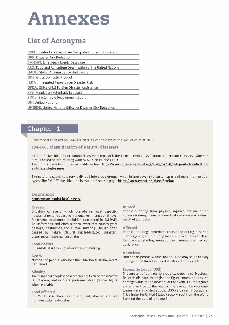
AnnexesList of Acronyms CRED: Centre for Research on the Epidemiology of DisastersDRR: Disaster Risk ReductionEM-DAT: Emergency Events DatabaseFAO: Food and Agriculture Organization of the United NationsGAUL: Global Administrative Unit LayersGDP: Gross Domestic ProductIRDR : Integrated Research on Disaster RiskOFDA: Office of US Foreign Disaster AssistancePPE: Population Potentially ExposedSDGs: Sustainable Development GoalsUN: United NationsUNISDR: United Nations Office for Disaster Risk Reduction
This report is based on EM-DAT data as of the date of the 14th of August 2018.
EM-DAT classification of natural dissaters
EM-DAT’s classification of natural disasters aligns with the IRDR’s “Peril Classification and Hazard Glossary” which in turn is based on pre-existing work by Munich RE and CRED.The IRDR’s classification is available online: http://www.irdrinternational.org/2014/03/28/irdr-peril-classification-and-hazard-glossary/
The natural disaster category is divided into 6 sub-groups, which in turn cover 17 disaster types and more than 30 sub-types. The EM-DAT classification is available on this page: https://www.emdat.be/classification
Definitionshttps://www.emdat.be/Glossary
Disaster Situation or event, which overwhelms local capacity, necessitating a request to national or international level for external assistance (definition considered in EM-DAT); An unforeseen and often sudden event that causes great damage, destruction and human suffering. Though often caused by nature (Natural Hazard-Induced Disaster), disasters can have human origins.
Total deaths In EM-DAT, it is the sum of deaths and missing.
Death Number of people who lost their life because the event happened.
MissingThe number of people whose whereabouts since the disaster is unknown, and who are presumed dead (official figure when available).
Total affectedIn EM-DAT, it is the sum of the injured, affected and left homeless after a disaster.
InjuredPeople suffering from physical injuries, trauma or an illness requiring immediate medical assistance as a direct result of a disaster. AffectedPeople requiring immediate assistance during a period of emergency, i.e. requiring basic survival needs such as food, water, shelter, sanitation and immediate medical assistance.
HomelessNumber of people whose house is destroyed or heavily damaged and therefore need shelter after an event.
Economic losses (US$)The amount of damage to property, crops, and livestock. For each disaster, the registered figure corresponds to the damage value at the moment of the event, i.e. the figures are shown true to the year of the event. The economic losses were adjusted at 2017 US$ value using Consumer Price Index for United States (2010 = 100) from the World Bank (at the date of June 2018).
26 | Economic Losses, Poverty and Disasters 1998-2017
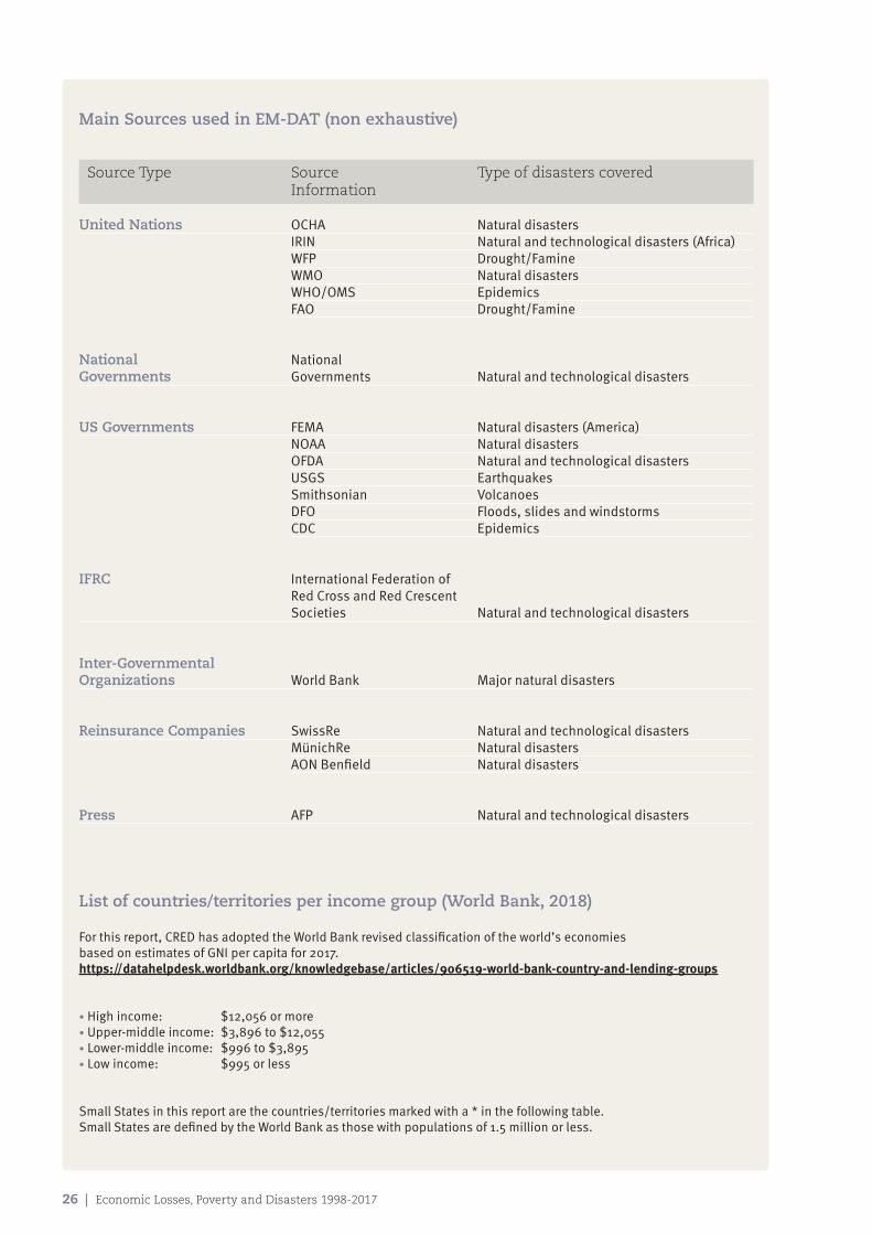
Main Sources used in EM-DAT (non exhaustive)
Source Type Source Type of disasters covered Information
United Nations OCHA Natural disasters IRIN Natural and technological disasters (Africa) WFP Drought/Famine WMO Natural disasters WHO/OMS Epidemics FAO Drought/Famine
National National Governments Governments Natural and technological disasters
US Governments FEMA Natural disasters (America) NOAA Natural disasters OFDA Natural and technological disasters USGS Earthquakes Smithsonian Volcanoes DFO Floods, slides and windstorms CDC Epidemics
IFRC International Federation of Red Cross and Red Crescent Societies Natural and technological disasters
Inter-Governmental Organizations World Bank Major natural disasters
Reinsurance Companies SwissRe Natural and technological disasters MünichRe Natural disasters AON Benfield Natural disasters
Press AFP Natural and technological disasters
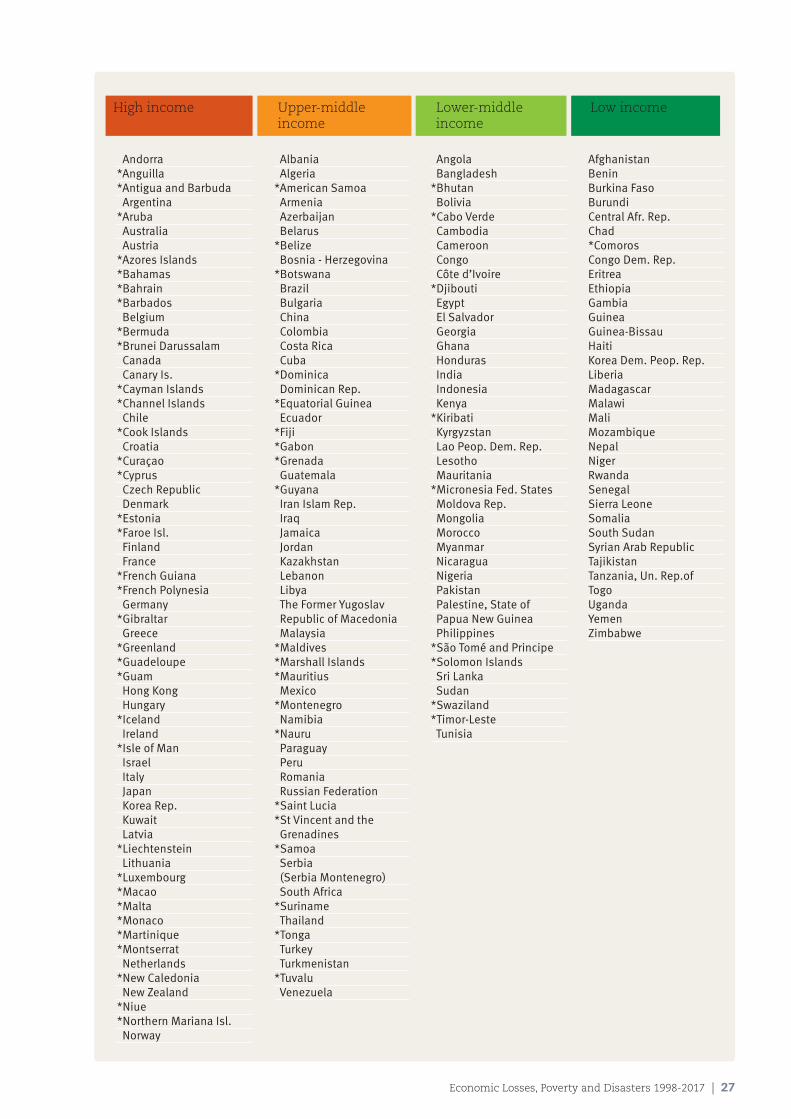
List of countries/territories per income group (World Bank, 2018)
For this report, CRED has adopted the World Bank revised classification of the world’s economies based on estimates of GNI per capita for 2017. https://datahelpdesk.worldbank.org/knowledgebase/articles/906519-world-bank-country-and-lending-groups
• High income: $12,056 or more • Upper-middle income: $3,896 to $12,055• Lower-middle income: $996 to $3,895• Low income: $995 or less
Small States in this report are the countries/territories marked with a * in the following table. Small States are defined by the World Bank as those with populations of 1.5 million or less.
Economic Losses, Poverty and Disasters 1998-2017 | 27
High income Upper-middle Lower-middle Low income income income
Andorra*Anguilla*Antigua and Barbuda Argentina*Aruba Australia Austria*Azores Islands*Bahamas*Bahrain*Barbados Belgium*Bermuda*Brunei Darussalam Canada Canary Is.*Cayman Islands *Channel Islands Chile*Cook Islands Croatia*Curaçao*Cyprus Czech Republic Denmark*Estonia*Faroe Isl. Finland France*French Guiana*French Polynesia Germany*Gibraltar Greece*Greenland*Guadeloupe*Guam Hong Kong Hungary*Iceland Ireland*Isle of Man Israel Italy Japan Korea Rep. Kuwait Latvia*Liechtenstein Lithuania*Luxembourg*Macao*Malta*Monaco*Martinique*Montserrat Netherlands *New Caledonia New Zealand*Niue*Northern Mariana Isl. Norway
Albania Algeria*American Samoa Armenia Azerbaijan Belarus*Belize Bosnia - Herzegovina*Botswana Brazil Bulgaria China Colombia Costa Rica Cuba*Dominica Dominican Rep.*Equatorial Guinea Ecuador*Fiji*Gabon*Grenada Guatemala*Guyana Iran Islam Rep. Iraq Jamaica Jordan Kazakhstan Lebanon Libya The Former Yugoslav Republic of Macedonia Malaysia*Maldives*Marshall Islands *Mauritius Mexico*Montenegro Namibia*Nauru Paraguay Peru Romania Russian Federation *Saint Lucia*St Vincent and the Grenadines*Samoa Serbia (Serbia Montenegro) South Africa*Suriname Thailand*Tonga Turkey Turkmenistan*Tuvalu Venezuela
Angola Bangladesh*Bhutan Bolivia *Cabo Verde Cambodia Cameroon Congo Côte d’Ivoire*Djibouti Egypt El Salvador Georgia Ghana Honduras India Indonesia Kenya*Kiribati Kyrgyzstan Lao Peop. Dem. Rep. Lesotho Mauritania*Micronesia Fed. States Moldova Rep. Mongolia Morocco Myanmar Nicaragua Nigeria Pakistan Palestine, State of Papua New Guinea Philippines *São Tomé and Principe*Solomon Islands Sri Lanka Sudan *Swaziland*Timor-Leste Tunisia
AfghanistanBeninBurkina FasoBurundiCentral Afr. Rep.Chad*ComorosCongo Dem. Rep.EritreaEthiopiaGambia GuineaGuinea-BissauHaitiKorea Dem. Peop. Rep.LiberiaMadagascarMalawiMaliMozambiqueNepalNiger RwandaSenegalSierra LeoneSomaliaSouth SudanSyrian Arab RepublicTajikistanTanzania, Un. Rep.ofTogoUgandaYemenZimbabwe
28 | Economic Losses, Poverty and Disasters 1998-2017
Chapter | 2
Calculation of economic losses related to GDP
To calculate this proportion, only GDP data for the year and country where a value for economic losses was available were taken into account. Thus if for certain years the economic losses are nil or unknown, GDP for this country is not taken into account.
The percentage calculated is equal to the sum of economic losses for a year ‘j’, multiplied by 100, and divided by the GDP for the same year ‘j’ for each country. The final percentage for the country for the period 1998-2017 is the average of the previous calculated percentages.
Economic losses as % of GDP for i = average
x = economic losses ( x > 0)i = countryj = year (from 1998 to 2017)
Same methodology is used for the calculation by income group:
Economic losses as % of GDP for z = average
z = income group
xij * 100GDP ij( )
xij * 100GDP ij( )
High income Upper-middle Lower-middle Low income income income
Oman*Palau Panama Poland Portugal Puerto Rico Qatar*Réunion*Saint Barthélemy*St Helena, Ascension and Tristan da Cunha*Saint Kitts and Nevis*Saint Martin (French)*San Marino Saudi Arabia*Seychelles Singapore*Sint Maarten (Dutch) Slovakia Slovenia Spain Sweden Switzerland Taiwan (China)*Tokelau*Trinidad and Tobago*Turks and Caicos Isl. United Arab Emirates United Kingdom United States Uruguay*Virgin Isl.(British)*Virgin Isl. (U.S.)*Wallis and Futuna
Economic Losses, Poverty and Disasters 1998-2017 | 29
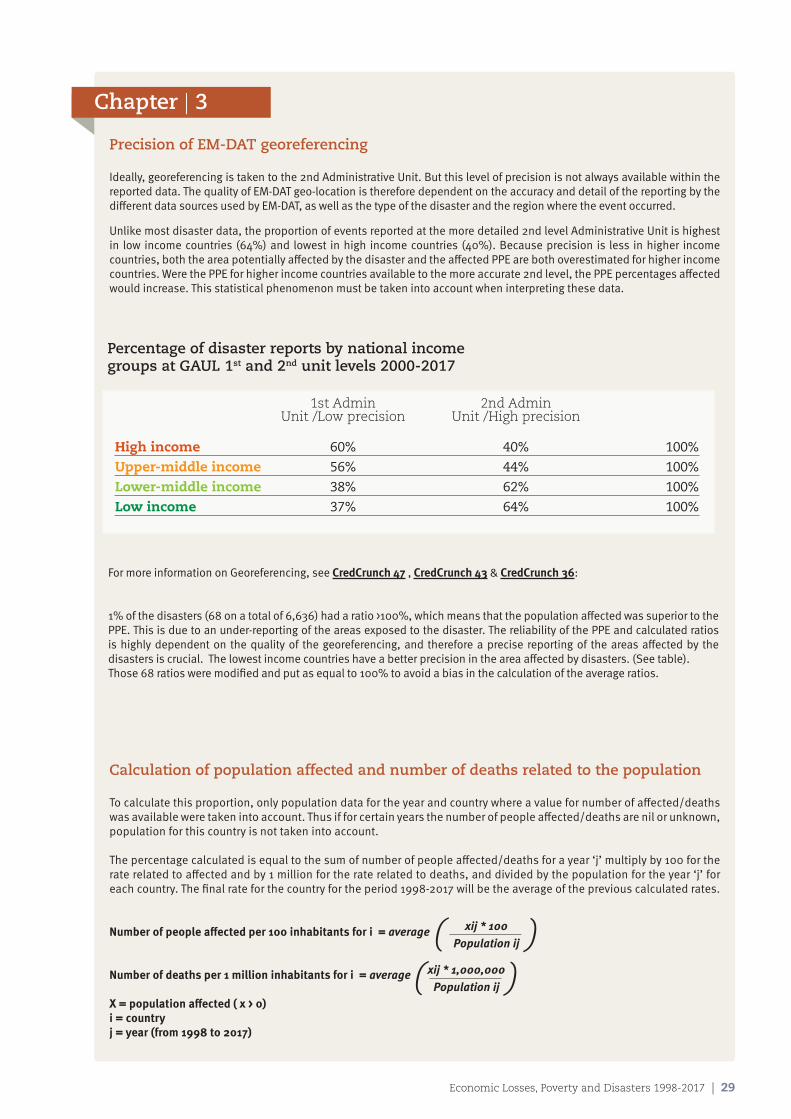
Chapter | 3
Precision of EM-DAT georeferencing
Ideally, georeferencing is taken to the 2nd Administrative Unit. But this level of precision is not always available within the reported data. The quality of EM-DAT geo-location is therefore dependent on the accuracy and detail of the reporting by the different data sources used by EM-DAT, as well as the type of the disaster and the region where the event occurred.
Unlike most disaster data, the proportion of events reported at the more detailed 2nd level Administrative Unit is highest in low income countries (64%) and lowest in high income countries (40%). Because precision is less in higher income countries, both the area potentially affected by the disaster and the affected PPE are both overestimated for higher income countries. Were the PPE for higher income countries available to the more accurate 2nd level, the PPE percentages affected would increase. This statistical phenomenon must be taken into account when interpreting these data.
For more information on Georeferencing, see CredCrunch 47 , CredCrunch 43 & CredCrunch 36:
1% of the disasters (68 on a total of 6,636) had a ratio >100%, which means that the population affected was superior to the PPE. This is due to an under-reporting of the areas exposed to the disaster. The reliability of the PPE and calculated ratios is highly dependent on the quality of the georeferencing, and therefore a precise reporting of the areas affected by the disasters is crucial. The lowest income countries have a better precision in the area affected by disasters. (See table).Those 68 ratios were modified and put as equal to 100% to avoid a bias in the calculation of the average ratios.
Percentage of disaster reports by national income groups at GAUL 1st and 2nd unit levels 2000-2017
1st Admin 2nd Admin Unit /Low precision Unit /High precision
High income 60% 40% 100%
Upper-middle income 56% 44% 100%
Lower-middle income 38% 62% 100%
Low income 37% 64% 100%
Calculation of population affected and number of deaths related to the population
To calculate this proportion, only population data for the year and country where a value for number of affected/deaths was available were taken into account. Thus if for certain years the number of people affected/deaths are nil or unknown, population for this country is not taken into account.
The percentage calculated is equal to the sum of number of people affected/deaths for a year ‘j’ multiply by 100 for the rate related to affected and by 1 million for the rate related to deaths, and divided by the population for the year ‘j’ for each country. The final rate for the country for the period 1998-2017 will be the average of the previous calculated rates.
Number of people affected per 100 inhabitants for i = average
Number of deaths per 1 million inhabitants for i = average
X = population affected ( x > 0)i = countryj = year (from 1998 to 2017)
xij * 100Population ij( )
xij * 1,000,000Population ij( )
Acknowledgements
This report is the outcome of a fruitful collaboration between the United Nations Office for Disaster Risk Reduction (UNISDR) and the Centre for Research on the Epidemiology of Disasters (CRED), part of the Institute of Health and Society (Université catholique de Louvain).
The analysis in this report was undertaken by Pascaline Wallemacq, who also coordinated and supervised the realization of this study.
The text was rewritten and edited by Rowena House, to whom we are grateful for the quality of her work.
Denis McClean, UNISDR, provided insightful inputs and helped refine the text.
Thanks to Regina Below who has maintained the EM-DAT database for 20 years and who contributed with her past work and ideas.
Mardi SPRL did the layout and infographics, and we would like to thank them for their valuable work.
Debarati Guha-Sapir
30 | Economic Losses, Poverty and Disasters 1998-2017
Contact
CRED
• Mail: Pascaline Wallemacq: [email protected] Regina Below: [email protected]
• Phone: +32 2 764 3327
• Postal Address: School of Public Health Institute of Health and Society (IRSS) Université catholique de Louvain Clos Chapelle-aux-Champs, 30, Bte B1.30.15 1200 Brussels, BELGIUM
www.emdat.be
UNISDR
• Mail: Denis McClean: [email protected]
• Phone: +41 22 917 8897
• Postal Address: 9-11 Rue de Varembé CH 1202, Geneva SWITZERLAND
www.unisdr.org
des
ign
: ww
w.m
ard
i.be
We gratefully acknowledge partial support for this analysis from the United States Agency for International Development (USAID) as well as the Université catholique de Louvain (UCL), Institute of Health and Society (IRSS).
The contents of this report remain the responsibility of the authors alone.
@CREDUCL