Embed Size (px)
Citation preview

EcoManage ProjectEcoManage Project
Hydrodynamical ChallengesHydrodynamical Challenges
Francisco Javier CampuzanoFrancisco Javier Campuzano

Sites LocationsSites Locations
Santos Estuary, BrazilSantos Estuary, Brazil Bahía Blanca Estuary, ArgentinaBahía Blanca Estuary, Argentina Aysén Fjord, ChileAysén Fjord, Chile

Fiordo Aysén
Santos Estuary
Bahía Blanca Estuary
Sites LocationsSites Locations

Santos EstuarySantos Estuary
Located approximately at 24º SLocated approximately at 24º S Precipitation: 2000-2500 mmyPrecipitation: 2000-2500 mmy-1-1
Mean Temperature 22º CMean Temperature 22º C
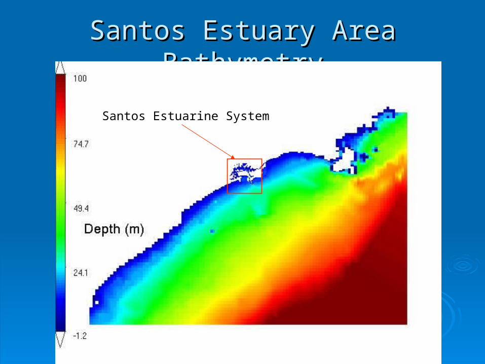
Santos Estuary Area BathymetrySantos Estuary Area Bathymetry
Santos Estuarine System

Santos Estuary Inner BathymetrySantos Estuary Inner Bathymetry

Hydrodynamical FeaturesHydrodynamical Features
Presents three channels (Santos, Sâo Presents three channels (Santos, Sâo Vicente & Bertioga)Vicente & Bertioga)
Small water exchanges through the Bertioga Small water exchanges through the Bertioga ChannelChannel
Watershed limited by Serra do MarWatershed limited by Serra do Mar Winds: Spring -» East Winds: Spring -» East April-September -» South April-September -» South

Hydrodynamical Features cont.Hydrodynamical Features cont.
Mainly forced by:Mainly forced by: TidesTides Local WindLocal Wind Southern windsSouthern winds
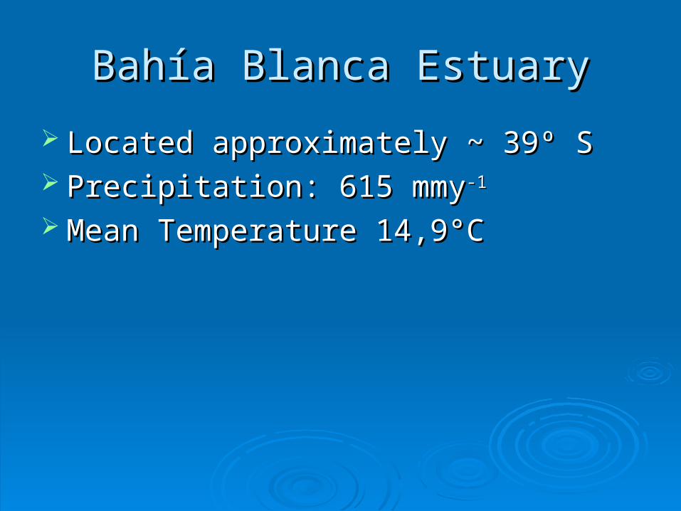
Bahía Blanca EstuaryBahía Blanca Estuary
Located approximately ~ 39º SLocated approximately ~ 39º S Precipitation: 615 mmyPrecipitation: 615 mmy-1-1
Mean Temperature 14,9°C Mean Temperature 14,9°C

Bahía Blanca Area BathymetryBahía Blanca Area BathymetryBahía Blanca Estuary

Bahía Blanca GeomorphologyBahía Blanca Geomorphology

Bahía Blanca CurrentsBahía Blanca Currents

Hydrodynamical FeaturesHydrodynamical Features
Mesotidal Coastal Plain (~4m Oscillation)Mesotidal Coastal Plain (~4m Oscillation) Various Channels, low depthVarious Channels, low depth Strong Tidal CurrentsStrong Tidal Currents Semidiurnal Tidal Wave, Standind WaveSemidiurnal Tidal Wave, Standind Wave Uniform Vertical Distribution of Oceanographic Uniform Vertical Distribution of Oceanographic
ParametersParameters Predominant NW windsPredominant NW winds Several Streams DischargingSeveral Streams Discharging Low mean annual runoff in tributariesLow mean annual runoff in tributaries

Aysén FjordAysén Fjord
Located approximately ~45º SLocated approximately ~45º S 2000-4000 mm year2000-4000 mm year-1 -1 (V. Marín)(V. Marín) 1100-2100 mm year1100-2100 mm year-1-1 (Caceres (Caceres et alet al, 2002)2002) Fresh water from at least 5 rivers; the most Fresh water from at least 5 rivers; the most
important is Río Aysén (700 mimportant is Río Aysén (700 m33ss-1-1) all others ) all others
represent (< 100 mrepresent (< 100 m33ss-1-1). ).

Aysén Area BathymetryAysén Area Bathymetry
Aysen Fjord
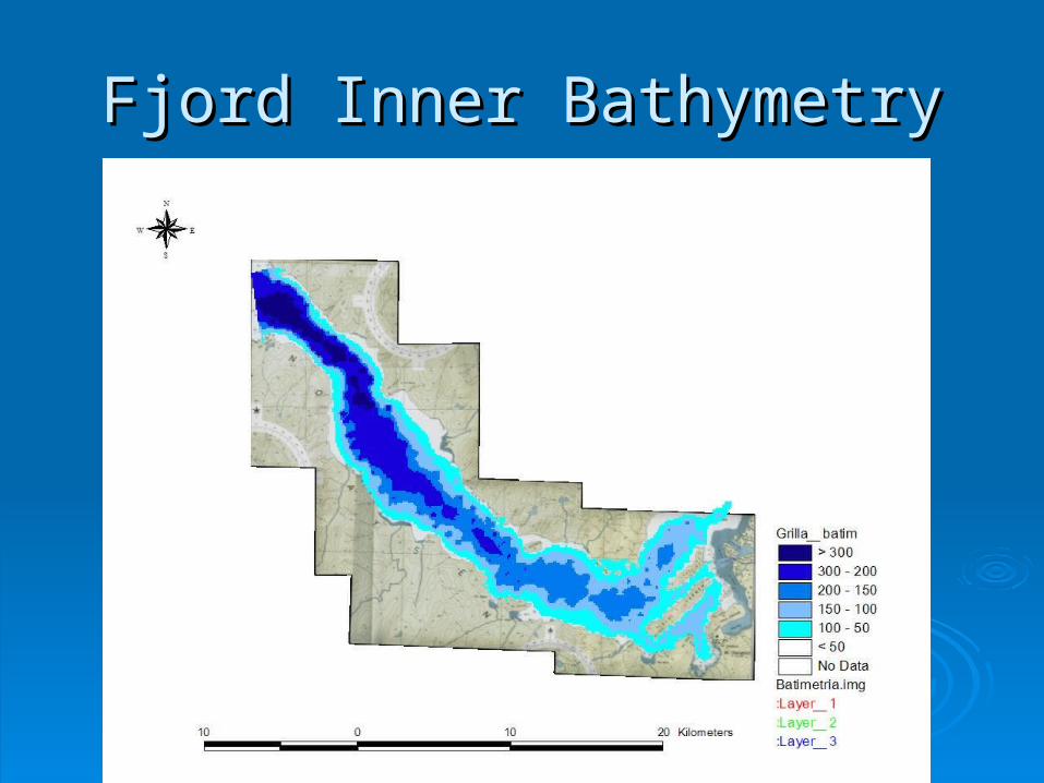
Fjord Inner BathymetryFjord Inner Bathymetry

Water Elevation (m)Water Elevation (m)

Currents (m/s)Currents (m/s)

Hydrodynamical FeaturesHydrodynamical Features
Mainly forced by tides predominantly semidiurnalMainly forced by tides predominantly semidiurnal Winds very important (Caceres Winds very important (Caceres et alet al, 2002), 2002) Steep Bathymetry (max depth ~350m)Steep Bathymetry (max depth ~350m) Average width 6.5 kmAverage width 6.5 km Total lenght 65 kmTotal lenght 65 km Little affected by remote forcing generated on the coastal Little affected by remote forcing generated on the coastal
shelfshelf Wind regime Spring-Summer-»S and SWWind regime Spring-Summer-»S and SW Fall-Winter-» N and NWFall-Winter-» N and NW Brackish water leaves leaves on the Southern partBrackish water leaves leaves on the Southern part Salty tidal intrusion goes into through the NorthSalty tidal intrusion goes into through the North

Future StepsFuture Steps
Get hold of the data from the partners!!Get hold of the data from the partners!! Modify and double check the Santos Modify and double check the Santos
estuary bathymetryestuary bathymetry Start setting the son model domainsStart setting the son model domains Validate the data from this modelsValidate the data from this models Chech the available bibliography for rates Chech the available bibliography for rates
and constants for each area.and constants for each area.


![Negative Refractive Index in Hydrodynamical SystemsNote that in [3] it was already argued that negative refraction is an ubiquitous phe-nomenon in hydrodynamical charged systems, supporting](https://img.pdfslide.us/doc/110x75/5e3d68c5d7c54a0ac77a6533/negative-refractive-index-in-hydrodynamical-systems-note-that-in-3-it-was-already.jpg)


![[Alfonso de Julios-Campuzano] La Globalizacion Ilu(BookFi.org)](https://img.pdfslide.us/doc/110x75/55cf861b550346484b9452fc/alfonso-de-julios-campuzano-la-globalizacion-ilubookfiorg.jpg)