Embed Size (px)
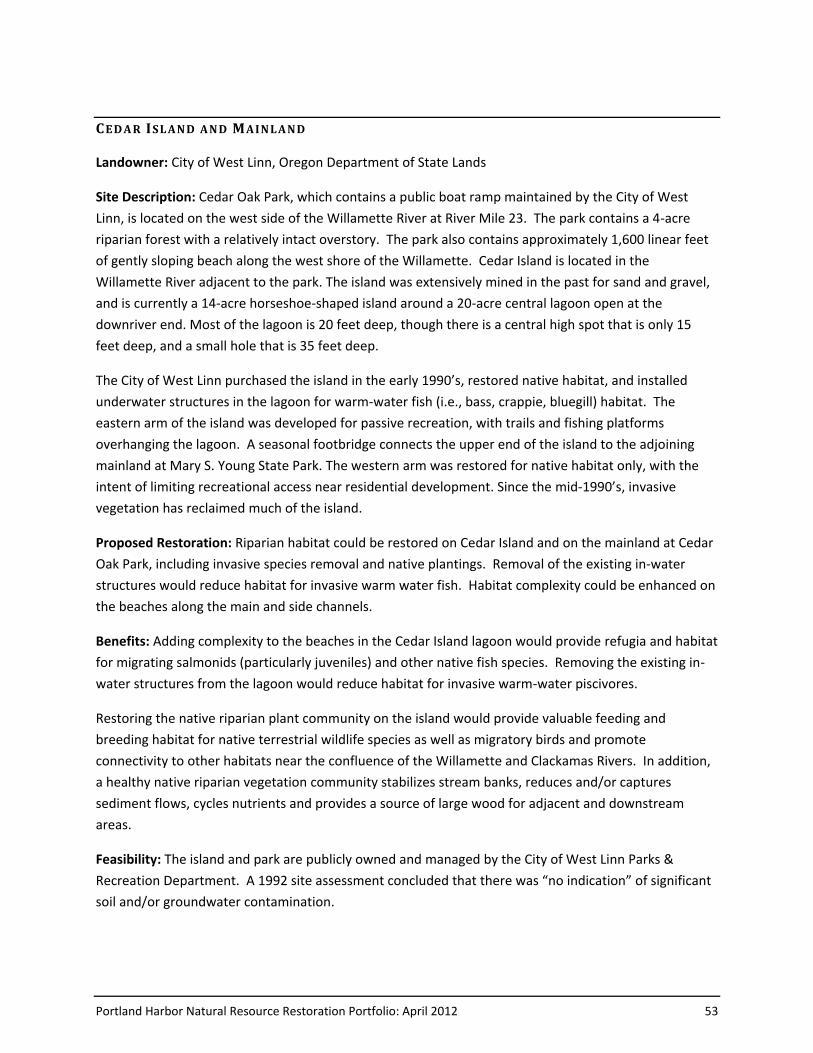
Citation preview
Portland Harbor Natural Resource Restoration Portfolio: April 2012 1
Ecological Restoration Portfolio
The Portland Harbor Natural Resource Trustee Council is engaged in restoration planning to develop a
suite of restoration opportunities that may compensate for the liability of potentially responsible parties
of the Portland Harbor Superfund Site. In order to develop this suite of restoration opportunities or
“restoration portfolio”, the Trustee Council developed criteria for identifying and evaluating potential
ecological restoration sites in 2008. These criteria address habitat features and attributes for several
potentially injured species, including salmon, lamprey, sturgeon, bald eagle, osprey, spotted sandpiper,
and mink. These criteria are used to evaluate a site’s ability to provide habitat “lift” in terms of benefits
to potentially injured species in Portland Harbor by comparing existing condition to potential restored
condition.
The Trustee Council has identified potential restoration sites within the Portland Harbor NRDA Study
Area (RM 0.8-12.3), and outside of the Study Area. To identify potential restoration sites inside the
Study Area, the Trustee Council reviewed restoration opportunities identified in the City of Portland’s
River Plan (2008), and the City of Portland’s draft Ecosystem Restoration General Investigation Study
(2005). The Trustee Council screened these opportunities against the ecological restoration criteria
developed in 2008, conducted site visits, and applied institutional knowledge of the Trustees and their
technical staff. A few additional sites (not identified in City documents) were also identified and
screened against the criteria. As a result of this effort, 25 restoration opportunities within the Study
Area have been identified by the Trustee Council as having potential to provide significant habitat
improvement for potentially injured natural resources in Portland Harbor, and are included in this
restoration portfolio.
In 2009, an expert panel was convened by the Trustee Council to discuss ecological restoration priorities
and opportunities outside of the Study Area in the lower Willamette River system. This panel identified a
“broader focus area” where restoration will be most likely to provide benefit to Portland Harbor’s
potentially injured species. In 2010 and 2011, the Trustee Council hosted a series of meetings with
potential community partners and potentially responsible parties to help identify restoration
opportunities in Portland Harbor’s broader focus area. Following the meetings, community
organizations and members proposed nearly forty sites in the area. From summer 2010 through fall
2011, the Council’s Restoration Committee conducted site visits and evaluations of the proposed sites.
The proposed sites in the Broader Focus Area were screened against the Trustee Council’s ecological
restoration criteria (2008) to determine whether they could produce habitat “lift” for potentially injured
species in Portland Harbor. As a result, 21 potential projects in the Broader Focus Area are included in
this portfolio.
2 Portland Harbor Natural Resource Restoration Portfolio: April 2012
This list represents an initial inventory of restoration opportunities, and is not intended to be
comprehensive or exclusive of opportunities that may be identified in the future. In addition, there is no
obligation on the part of landowners to allow restoration work to take place at any particular site.
Attachments to this list include: an overview map showing the location of each site on the river; a brief
description of each site, including conceptual restoration treatments and their anticipated benefits; and
a conceptual figure for each site. Specific quantitative value or restoration credit that may be generated
by any of these projects will ultimately be determined using Habitat Equivalency Analysis. Federal
Trustees will complete all required consultations and other permitting under the National
Environmental Policy Act, the Endangered Species Act, the Clean Water Act and other statutes before
project implementation begins.
Portland Harbor Natural Resource Restoration Portfolio: April 2012 3
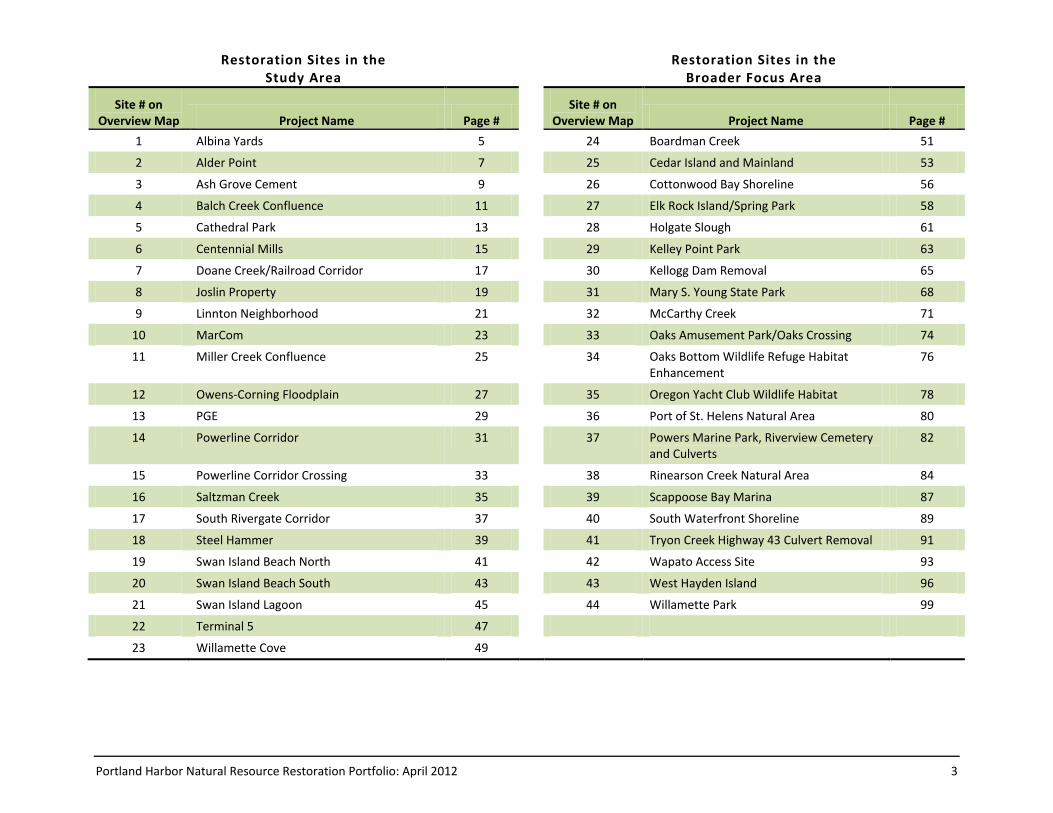
Restoration Sites in the Study Area
Restoration Sites in the Broader Focus Area
Site # on Overview Map Project Name Page #
Site # on Overview Map Project Name Page #
1 Albina Yards 5 24 Boardman Creek 51
2 Alder Point 7 25 Cedar Island and Mainland 53
3 Ash Grove Cement 9 26 Cottonwood Bay Shoreline 56
4 Balch Creek Confluence 11 27 Elk Rock Island/Spring Park 58
5 Cathedral Park 13 28 Holgate Slough 61
6 Centennial Mills 15 29 Kelley Point Park 63
7 Doane Creek/Railroad Corridor 17 30 Kellogg Dam Removal 65
8 Joslin Property 19 31 Mary S. Young State Park 68
9 Linnton Neighborhood 21 32 McCarthy Creek 71
10 MarCom 23 33 Oaks Amusement Park/Oaks Crossing 74
11 Miller Creek Confluence 25 34 Oaks Bottom Wildlife Refuge Habitat Enhancement
76
12 Owens-Corning Floodplain 27 35 Oregon Yacht Club Wildlife Habitat 78
13 PGE 29 36 Port of St. Helens Natural Area 80
14 Powerline Corridor 31 37 Powers Marine Park, Riverview Cemetery and Culverts
82
15 Powerline Corridor Crossing 33 38 Rinearson Creek Natural Area 84
16 Saltzman Creek 35 39 Scappoose Bay Marina 87
17 South Rivergate Corridor 37 40 South Waterfront Shoreline 89
18 Steel Hammer 39 41 Tryon Creek Highway 43 Culvert Removal 91
19 Swan Island Beach North 41 42 Wapato Access Site 93
20 Swan Island Beach South 43 43 West Hayden Island 96
21 Swan Island Lagoon 45 44 Willamette Park 99
22 Terminal 5 47
23 Willamette Cove 49
5
5
205
84
26
30
205
Willamette Falls
Tryon Creek
WA SH I N G TON
O R E GON
MILE0 1
N
Scappoose Bay
Multnom
ah Channel
Willamette River
Columbia River
Johnson Creek
Clackamas River
Kellogg Creek
Sandy River
6
41
2119
20
2282
11 13 173
141512
9
7
10
16
23518
3936
29
42
32
43
2840
35
30
27
38
242531
41
44
26
343337
5
5
205
84
26
30
205
Willamette Falls
Tryon Creek
WA SH I N G TON
OR EGON
MILE
0 1
Scappoose Bay
Multnom
ah Channel
Willamette River
Columbia River
Johnson Creek
Clackamas River
Kellogg Creek
Sandy River
6
41
2119
20
2282
11 13 173
141512
9
7
10
16
23518
3936
29
42
32
43
2840
30
27
38
242531
41
37
44
26353433
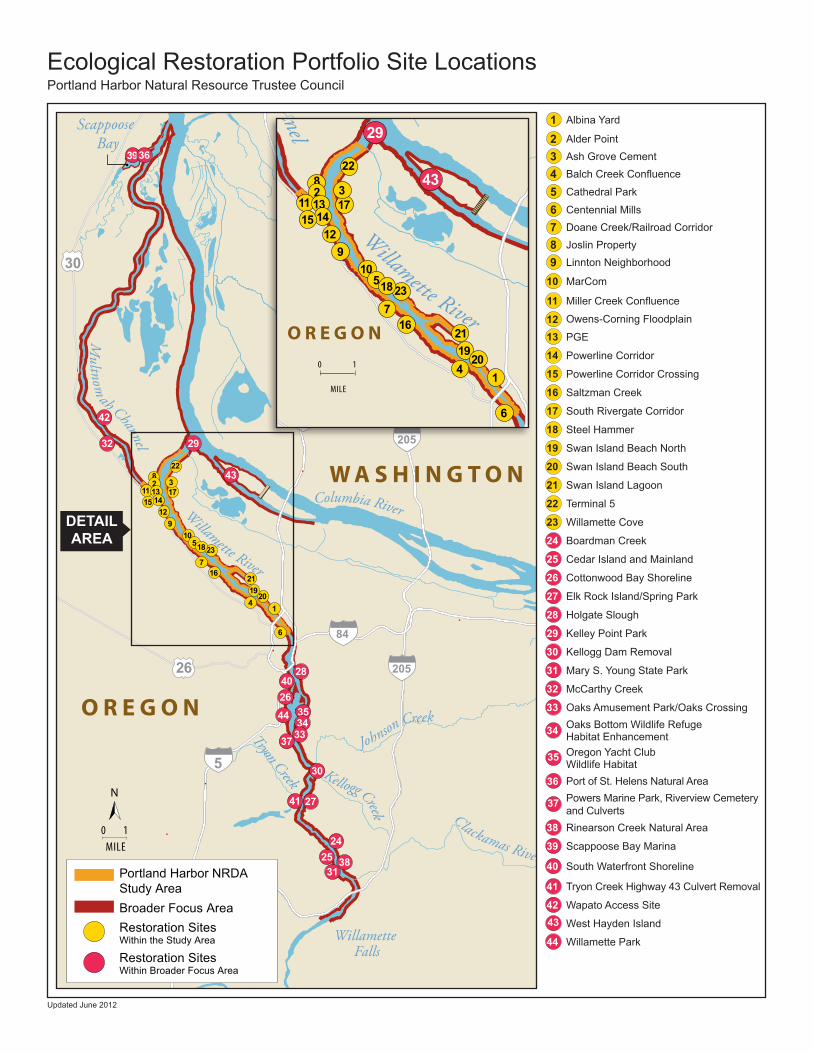
Ecological Restoration Portfolio Site LocationsPortland Harbor Natural Resource Trustee Council
1 Albina Yard
2 Alder Point
3 Ash Grove Cement
4 Balch Creek Confluence
5 Cathedral Park
6 Centennial Mills
7 Doane Creek/Railroad Corridor
8 Joslin Property
9 Linnton Neighborhood
10 MarCom
11 Miller Creek Confluence
12 Owens-Corning Floodplain
13 PGE
14 Powerline Corridor
15 Powerline Corridor Crossing
16 Saltzman Creek
17 South Rivergate Corridor
18 Steel Hammer
19 Swan Island Beach North
20 Swan Island Beach South
21 Swan Island Lagoon
22 Terminal 5
23 Willamette Cove
24 Boardman Creek
25 Cedar Island and Mainland
26 Cottonwood Bay Shoreline
27 Elk Rock Island/Spring Park
28 Holgate Slough
29 Kelley Point Park
30 Kellogg Dam Removal
31 Mary S. Young State Park
32 McCarthy Creek
33 Oaks Amusement Park/Oaks Crossing
34 Oaks Bottom Wildlife Refuge Habitat Enhancement
35 Oregon Yacht Club Wildlife Habitat
36 Port of St. Helens Natural Area
37 Powers Marine Park, Riverview Cemetery and Culverts
38 Rinearson Creek Natural Area
39 Scappoose Bay Marina
40 South Waterfront Shoreline
41 Tryon Creek Highway 43 Culvert Removal
42 Wapato Access Site43 West Hayden Island
44 Willamette Park
Portland Harbor NRDA Study AreaBroader Focus AreaRestoration Sites Within the Study Area
Restoration Sites Within Broader Focus Area
DETAILAREA
Updated June 2012
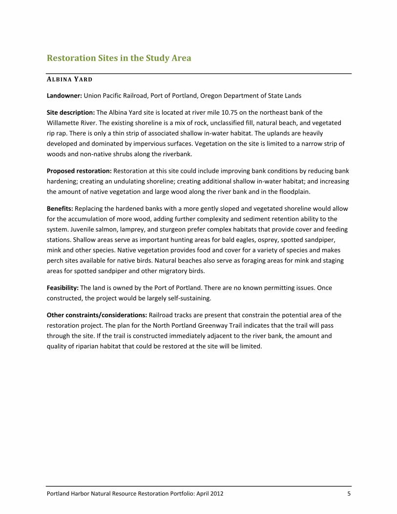
Portland Harbor Natural Resource Restoration Portfolio: April 2012 5
Restoration Sites in the Study Area
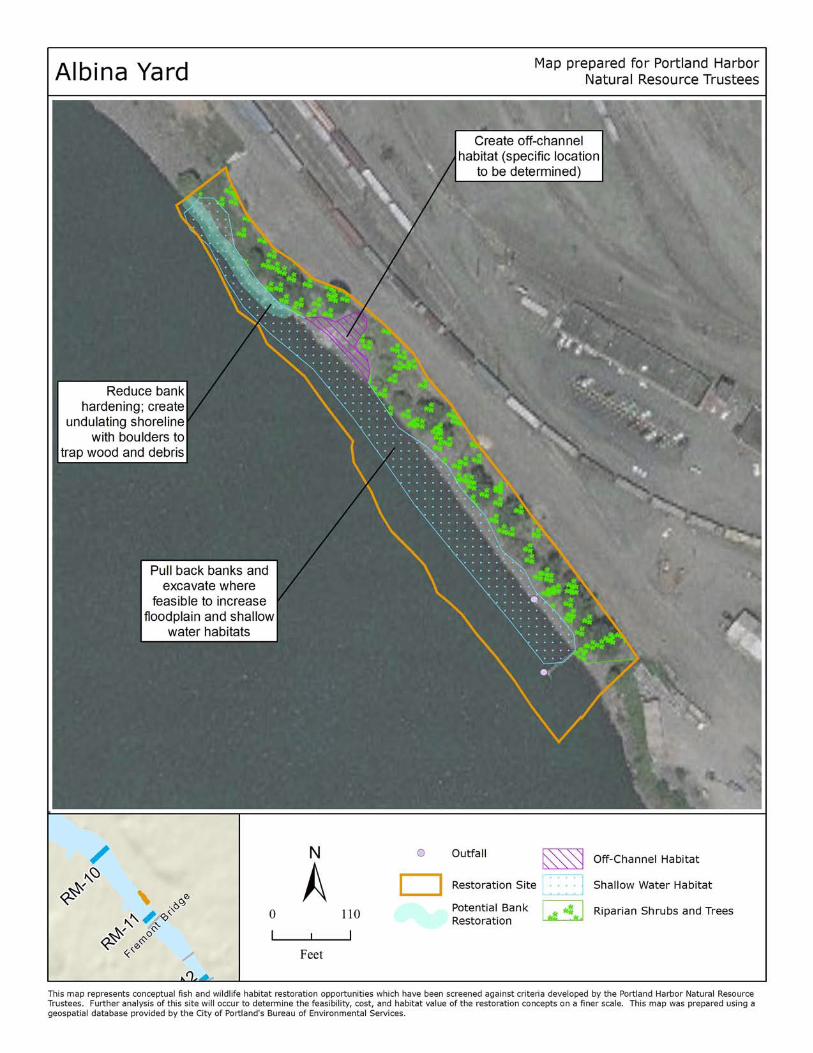
AL B IN A YARD
Landowner: Union Pacific Railroad, Port of Portland, Oregon Department of State Lands
Site description: The Albina Yard site is located at river mile 10.75 on the northeast bank of the
Willamette River. The existing shoreline is a mix of rock, unclassified fill, natural beach, and vegetated
rip rap. There is only a thin strip of associated shallow in‐water habitat. The uplands are heavily
developed and dominated by impervious surfaces. Vegetation on the site is limited to a narrow strip of
woods and non‐native shrubs along the riverbank.
Proposed restoration: Restoration at this site could include improving bank conditions by reducing bank
hardening; creating an undulating shoreline; creating additional shallow in‐water habitat; and increasing
the amount of native vegetation and large wood along the river bank and in the floodplain.
Benefits: Replacing the hardened banks with a more gently sloped and vegetated shoreline would allow
for the accumulation of more wood, adding further complexity and sediment retention ability to the
system. Juvenile salmon, lamprey, and sturgeon prefer complex habitats that provide cover and feeding
stations. Shallow areas serve as important hunting areas for bald eagles, osprey, spotted sandpiper,
mink and other species. Native vegetation provides food and cover for a variety of species and makes
perch sites available for native birds. Natural beaches also serve as foraging areas for mink and staging
areas for spotted sandpiper and other migratory birds.
Feasibility: The land is owned by the Port of Portland. There are no known permitting issues. Once
constructed, the project would be largely self-sustaining.
Other constraints/considerations: Railroad tracks are present that constrain the potential area of the
restoration project. The plan for the North Portland Greenway Trail indicates that the trail will pass
through the site. If the trail is constructed immediately adjacent to the river bank, the amount and
quality of riparian habitat that could be restored at the site will be limited.
Portland Harbor Natural Resource Restoration Portfolio: April 2012 7
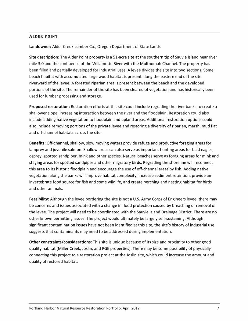
AL DE R PO IN T
Landowner: Alder Creek Lumber Co., Oregon Department of State Lands
Site description: The Alder Point property is a 51-acre site at the southern tip of Sauvie Island near river
mile 3.0 and the confluence of the Willamette River with the Multnomah Channel. The property has
been filled and partially developed for industrial uses. A levee divides the site into two sections. Some
beach habitat with accumulated large wood habitat is present along the eastern end of the site
riverward of the levee. A forested riparian area is present between the beach and the developed
portions of the site. The remainder of the site has been cleared of vegetation and has historically been
used for lumber processing and storage.
Proposed restoration: Restoration efforts at this site could include regrading the river banks to create a
shallower slope, increasing interaction between the river and the floodplain. Restoration could also
include adding native vegetation to floodplain and upland areas. Additional restoration options could
also include removing portions of the private levee and restoring a diversity of riparian, marsh, mud flat
and off-channel habitats across the site.
Benefits: Off-channel, shallow, slow moving waters provide refuge and productive foraging areas for
lamprey and juvenile salmon. Shallow areas can also serve as important hunting areas for bald eagles,
osprey, spotted sandpiper, mink and other species. Natural beaches serve as foraging areas for mink and
staging areas for spotted sandpiper and other migratory birds. Regrading the shoreline will reconnect
this area to its historic floodplain and encourage the use of off-channel areas by fish. Adding native
vegetation along the banks will improve habitat complexity, increase sediment retention, provide an
invertebrate food source for fish and some wildlife, and create perching and nesting habitat for birds
and other animals.
Feasibility: Although the levee bordering the site is not a U.S. Army Corps of Engineers levee, there may
be concerns and issues associated with a change in flood protection caused by breaching or removal of
the levee. The project will need to be coordinated with the Sauvie Island Drainage District. There are no
other known permitting issues. The project would ultimately be largely self-sustaining. Although
significant contamination issues have not been identified at this site, the site’s history of industrial use
suggests that contaminants may need to be addressed during implementation.
Other constraints/considerations: This site is unique because of its size and proximity to other good
quality habitat (Miller Creek, Joslin, and PGE properties). There may be some possibility of physically
connecting this project to a restoration project at the Joslin site, which could increase the amount and
quality of restored habitat.
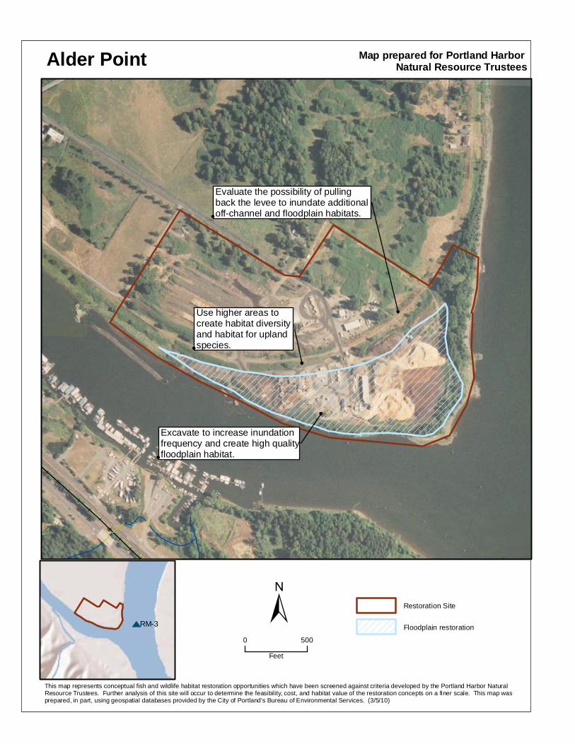
Alder Point
r
r
r
RM-3
r
Excavate to increase inundation frequency and create high quality floodplain habitat.
Use higher areas to create habitat diversity and habitat for upland species.
Evaluate the possibility of pulling back the levee to inundate additional off-channel and floodplain habitats.
Restoration Site
Floodplain restoration
Map prepared for Portland Harbor Natural Resource Trustees
This map represents conceptual fish and wildlife habitat restoration opportunities which have been screened against criteria developed by the Portland Harbor Natural Resource Trustees. Further analysis of this site will occur to determine the feasibility, cost, and habitat value of the restoration concepts on a finer scale. This map was prepared, in part, using geospatial databases provided by the City of Portland's Bureau of Environmental Services. (3/5/10)
±0 500
Feet
Portland Harbor Natural Resource Restoration Portfolio: April 2012 9
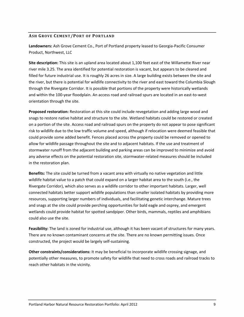
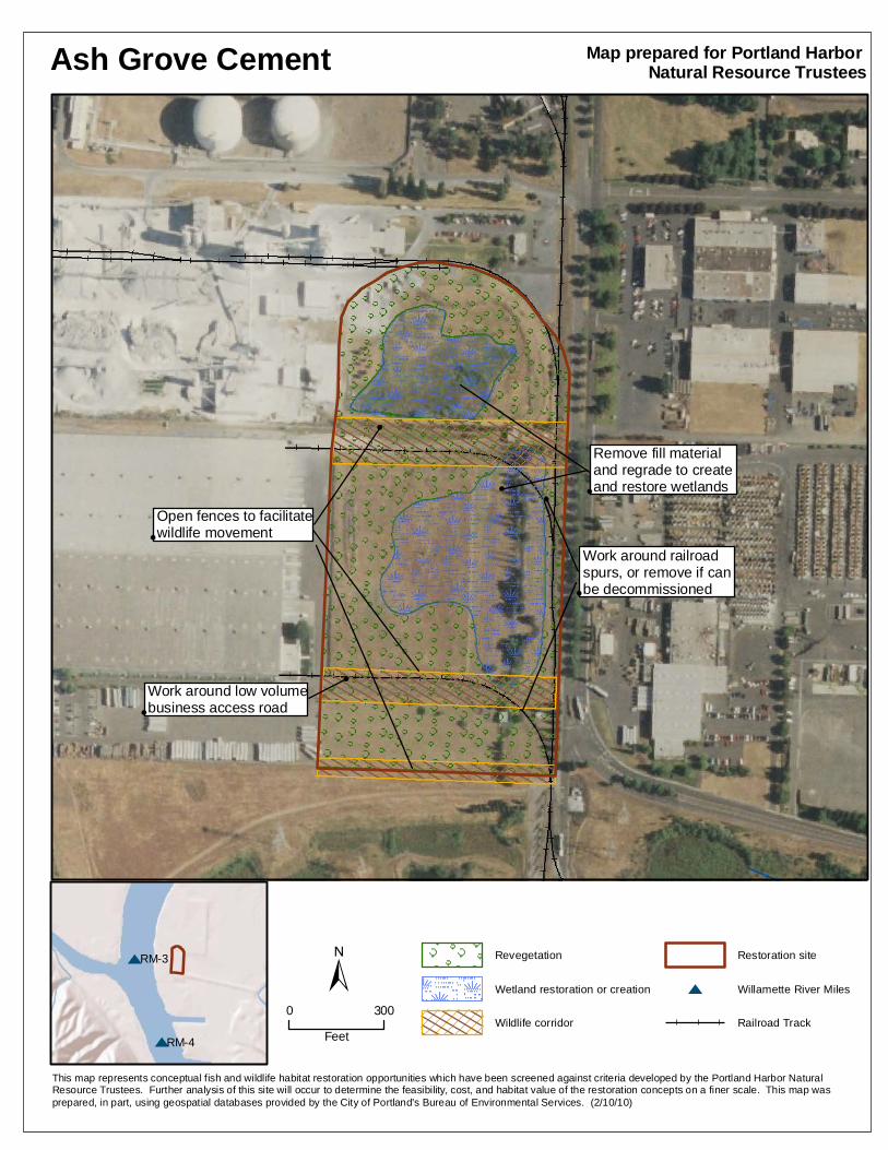
AS H GRO V E CEM EN T/PO RT OF PORT LA ND
Landowners: Ash Grove Cement Co., Port of Portland property leased to Georgia-Pacific Consumer
Product, Northwest, LLC
Site description: This site is an upland area located about 1,100 feet east of the Willamette River near
river mile 3.25. The area identified for potential restoration is vacant, but appears to be cleared and
filled for future industrial use. It is roughly 26 acres in size. A large building exists between the site and
the river, but there is potential for wildlife connectivity to the river and east toward the Columbia Slough
through the Rivergate Corridor. It is possible that portions of the property were historically wetlands
and within the 100-year floodplain. An access road and railroad spurs are located in an east-to-west
orientation through the site.
Proposed restoration: Restoration at this site could include revegetation and adding large wood and
snags to restore native habitat and structure to the site. Wetland habitats could be restored or created
on a portion of the site. Access road and railroad spurs on the property do not appear to pose significant
risk to wildlife due to the low traffic volume and speed, although if relocation were deemed feasible that
could provide some added benefit. Fences placed across the property could be removed or opened to
allow for wildlife passage throughout the site and to adjacent habitats. If the use and treatment of
stormwater runoff from the adjacent building and parking areas can be improved to minimize and avoid
any adverse effects on the potential restoration site, stormwater-related measures should be included
in the restoration plan.
Benefits: The site could be turned from a vacant area with virtually no native vegetation and little
wildlife habitat value to a patch that could expand on a larger habitat area to the south (i.e., the
Rivergate Corridor), which also serves as a wildlife corridor to other important habitats. Larger, well
connected habitats better support wildlife populations than smaller isolated habitats by providing more
resources, supporting larger numbers of individuals, and facilitating genetic interchange. Mature trees
and snags at the site could provide perching opportunities for bald eagle and osprey, and emergent
wetlands could provide habitat for spotted sandpiper. Other birds, mammals, reptiles and amphibians
could also use the site.
Feasibility: The land is zoned for industrial use, although it has been vacant of structures for many years.
There are no known contaminant concerns at the site. There are no known permitting issues. Once
constructed, the project would be largely self-sustaining.
Other constraints/considerations: It may be beneficial to incorporate wildlife crossing signage, and
potentially other measures, to promote safety for wildlife that need to cross roads and railroad tracks to
reach other habitats in the vicinity.
Ash Grove Cement
r
r
r
r
r
RM-4
RM-3
r
89:n
Open fence to facilitate wildlife movement
Revegetation
Wetland restoration or creation
Wildlife corridor
Restoration site
r Willamette River Miles
Railroad Track
Map prepared for Portland Harbor Natural Resource Trustees
This map represents conceptual fish and wildlife habitat restoration opportunities which have been screened against criteria developed by the Portland Harbor Natural Resource Trustees. Further analysis of this site will occur to determine the feasibility, cost, and habitat value of the restoration concepts on a finer scale. This map was prepared, in part, using geospatial databases provided by the City of Portland's Bureau of Environmental Services. (2/10/10)
±0 300
Feet
Open fences to facilitate wildlife movement
Work around railroad spurs, or remove if can be decommissioned
Work around low volume business access road
Remove fill material and regrade to create and restore wetlands
Portland Harbor Natural Resource Restoration Portfolio: April 2012 11
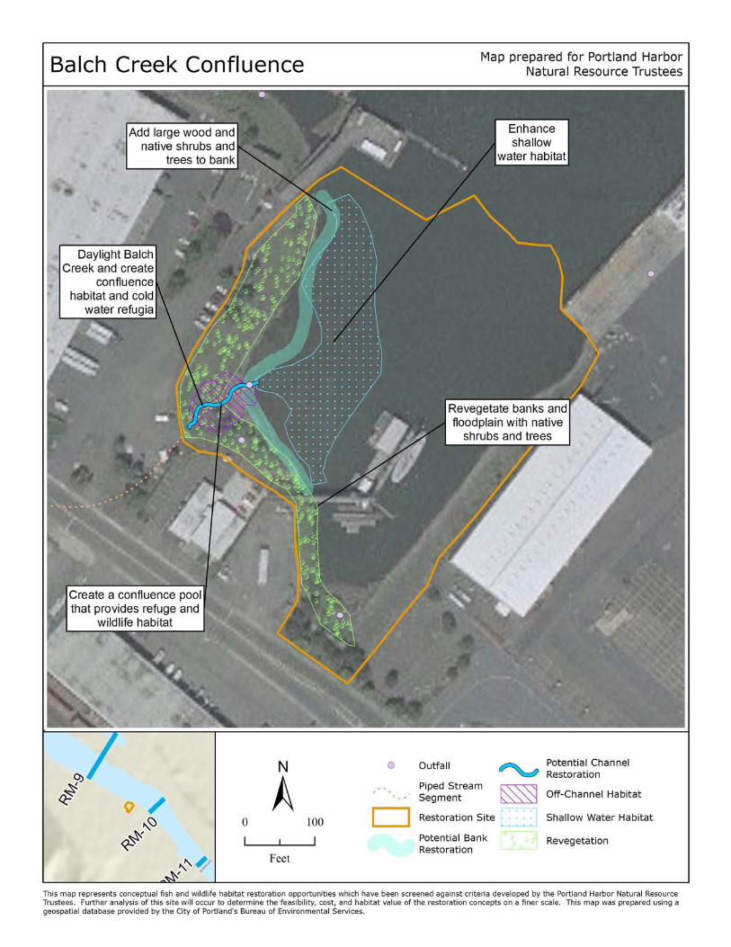
BA LC H CREE K CON FL UE NC E
Landowner: Port of Portland, Sause Brothers, Portland Fire Bureau, Oregon Department of State Lands
Site description: The Balch Creek Confluence site is located at river mile 9.85 along the west bank of the
Willamette River. Balch Creek is currently in a culvert and discharges to an alcove off the river. Part of
the alcove is occasionally dredged to maintain access to a fireboat dock, which reduces shallow in‐water
habitat in the alcove. The northern side of the alcove has some beach and shallow water habitat. The
banks of the alcove are steep with a thin strip of mostly non‐native riparian vegetation and are classified
by ODFW as vegetated rip rap. The site is surrounded by industrial development.
Proposed restoration: Restoration at the site could include “daylighting” Balch Creek near the alcove;
separating the combined sewer overflow and industrial stormwater runoff from Balch Creek;
constructing a confluence pool to create off‐channel wetland habitat; vegetating the riparian areas
along Balch Creek and the confluence area; adding complexity to shallow water habitat by adding large
wood. The option of moving the boat dock into deeper water to eliminate the need for maintenance
dredging could also be evaluated for feasibility.
Benefits: Naturally sloped, vegetated stream banks increase floodplain connectivity and habitat
diversity. Adding large wood and other habitat features would create more complex habitat, which is
preferred by juvenile salmon, lamprey, and sturgeon because it provides cover and feeding stations. Off‐
channel, shallow, slow moving waters, like the proposed wetland and “daylit” stream, gather wood and
provide refuge and productive foraging areas for lamprey and juvenile salmon. Shallow areas can also
serve as important hunting areas for bald eagle, osprey, spotted sandpiper, mink and other species.
Emergent and shrub wetlands provide shelter and a prey source for lamprey and salmon, as well as
native birds, reptiles and amphibians. Riparian vegetation provides trees for bald eagle and osprey
perching opportunities, and cover and foraging areas for mink and other species. The diversion of
stormwater from the creek would directly benefit water quality.
Feasibility: Remediation of sediment would be necessary prior to restoration. The site is owned by
private and public entities. There are no known permitting issues. Minor ongoing maintenance of plants
and hydrology may be required.
Other constraints/considerations: Balch Creek Confluence site offers a rare opportunity to restore the
mouth of a tributary on the mainstem Willamette. This project would be even more effective if the
Portland Fire boat were moved into deeper water closer to the main channel of the river. The upstream
portion of Balch Creek would remain in a culvert, limiting connectivity.
Portland Harbor Natural Resource Restoration Portfolio: April 2012 13
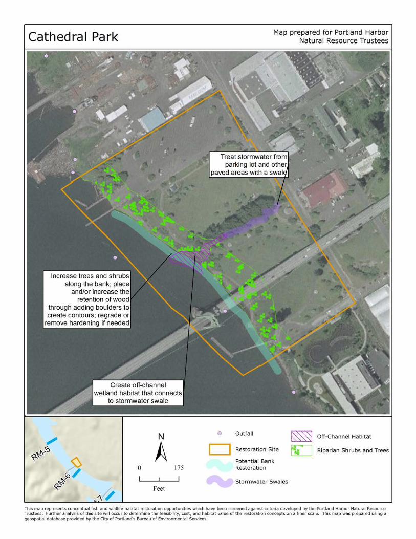
CA T HED RAL PA RK
Landowner: City of Portland Parks and Recreation, Oregon Department of State Lands
Site description: The site is located at river mile 5.75. Cathedral Park’s shore is classified as beach and
some driftwood is present. The uplands are largely dominated by a grass field and a large parking lot.
There is also a significant strip of woodland habitat containing large cottonwood trees and managed
herbaceous vegetation. A boat ramp extends from the parking lot into the open water and that portion
of the shoreline is composed of non‐vegetated rip rap. Near the center of the shoreline there appears to
be a section of shallow in‐water habitat.
Proposed restoration: Restoration will likely include increasing vegetation and wood to restore riparian
areas and upland habitat and creating off‐channel wetlands at the mouth of the swale.
Benefits: Beach habitats sustain rich invertebrate populations; consequently they are important
foraging areas for spotted sandpiper, mink, and a variety of other organisms. Naturally sloped,
vegetated stream banks increase floodplain connectivity and habitat diversity. Adding large wood and
other habitat features would create more complex habitat, which is preferred by juvenile salmon,
lamprey, and sturgeon because it provides cover and feeding stations. Off‐channel, shallow, slow
moving waters gather wood and provide refuge and productive foraging areas for lamprey and juvenile
salmon. Restoring native vegetation to the site would improve wildlife habitat.
Feasibility: The land is publicly owned. Portland Parks and Recreation is willing to build and maintain the
project, though there would be a significant amount of human access and potential disturbance. There
are no known permitting obstacles at this time. Minor ongoing maintenance of the stormwater facility
will be required.
Other constraints/considerations: The Portland Parks and Recreation Department’s preference that the
park be focused on recreation rather than habitat as illustrated in the Cathedral Park Master Plan will
likely limit opportunities to fully implement potential restoration actions at the site.
Portland Harbor Natural Resource Restoration Portfolio: April 2012 15
CE NTE N N IAL M ILL S
Landowner: City of Portland, Portland Development Commission, Oregon Department of State Lands
Site description: The Centennial Mills site is located at river mile 11.4 on the west bank of the
Willamette River. The riverbank is steeply sloped and classified as pilings, vegetated rip rap and
unclassified fill. There appears to be some shallow in‐water habitat along the shore. Tanner Creek is
piped throughout most of the Northwest Industrial Area and meets the Willamette River at a
stormwater outfall in the center of this site. The site itself is mostly impervious (81.4%) with a small strip
of shrubs along the river bank on the southeastern half.
Proposed restoration: Potential restoration activities at this site could involve rerouting and
“daylighting” the end of Tanner Creek; creating off‐channel and confluence habitat; treating stormwater
discharge from the Tanner outfall in a stormwater wetland; regrading and revegetating the river banks
and floodplain; and removing buildings and other infrastructure from the property.
Benefits: Rerouting and “daylighting” the creek will improve habitat complexity, enhancing the habitat
for salmon, lamprey, sturgeon, and terrestrial species. Creating additional tributary and wetland habitat
will increase off‐channel areas used by lamprey and juvenile salmon. Shallow areas can also serve as
important hunting areas for bald eagles, osprey, spotted sandpiper, mink and other species. Native
vegetation provides an invertebrate food source, cover, perching, and nesting habitat for birds and
other animals. Natural beaches and shallow wetlands also serve as foraging areas for mink and staging
areas for spotted sandpiper and other migratory birds. Restoring the stream and wetland will reconnect
this area to its historic floodplain and also enhance habitat complexity by encouraging the use of off‐
channel areas by fish. Treatment of the stormwater in a swale will directly improve water quality.
Feasibility: The land is publicly owned. The site has been declared a historical site. After restoration is
completed, minor ongoing maintenance of the stormwater treatment features will be required.
Other constraints/considerations: This site is rare and significant because of the potential to restore the
mouth of a tributary on the mainstem Willamette River. Development options for the property are
currently being considered and the site’s designation as a historical property may limit the restoration
options at the site.

Portland Harbor Natural Resource Restoration Portfolio: April 2012 17
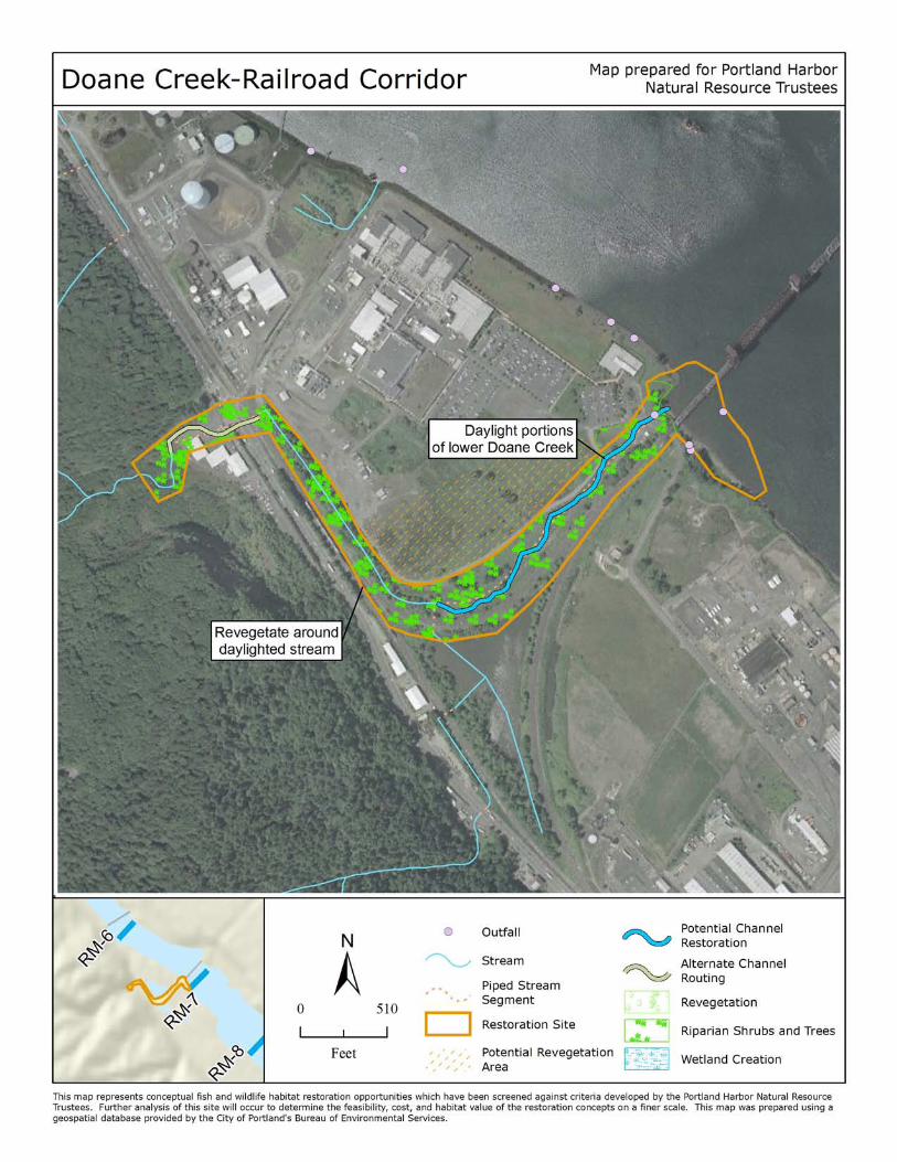
DO A NE CREE K / RA IL RO A D CO RRID O R
Landowner: Siltronics, Burlington Northern Santa Fe Railway, Atofina Chemicals Inc., Oregon
Department of State Lands
Site description: The Doane Creek site is located at river mile 7, extending from the shoreline just
upstream of the Burlington Northern Railroad Bridge to the uplands along Highway 30, and includes a 7
acre wetland known as North Doane Lake. A riparian forest borders Doane Lake. Doane Creek is a
stream that originates in Forest Park. The stream is piped under HWY 30, in an open channel for about
1600 ft., and then piped again until it connects to the river through an outfall. The shoreline is natural
beach south of the bridge and rip rap to the north. There are some areas of shallow in‐water habitat
along the beach. Heavy contamination upstream of the site has resulted in contamination of Doane
Lake.
Proposed restoration: Restoration at the Doane Creek site could include several components: creating
high quality habitat at the confluence; “daylighting” the piped sections of Doane Creek; restoring
connectivity for fish and wildlife between the site and Forest Park; enhancing shoreline and riparian
habitat by removing rip rap, regrading, and replanting with native vegetation; replanting upland areas of
the site with native vegetation; and creating more shallow in‐water habitat.
Benefits: Realigning and “daylighting” the creek and addressing fish passage barriers will improve
habitat complexity and connectivity, enhancing the habitat for salmon, lamprey, sturgeon, and
terrestrial species. Creating additional tributary and wetland habitat will increase off‐channel areas for
use by lamprey and salmon. Shallow areas can also serve as important hunting areas for bald eagles,
osprey, spotted sandpiper, mink and other species. Native vegetation would provide food, cover, and
nesting habitat for birds and other animals. Natural beaches and shallow wetlands serve as foraging
areas for mink and staging areas for spotted sandpiper and other migratory birds. Restoring the stream
will reconnect this area to its historic floodplain and provide off‐channel habitat.
Feasibility: The timeline for sediment/creek remediation is unknown; remediation must be completed
before restoration begins. Opportunities to restore passage for fish and wildlife between the site and
Forest Park need to be evaluated. The land is privately owned and it is not known if the owner is willing
to allow restoration at the site. There may be permitting issues, especially associated with the railroad.
A significant amount of effort would be necessary to monitor and maintain the modified hydrology and
plantings.
Other constraints/considerations: The site already provides a connection between Forest Park and the
Willamette River and good quality beach habitat. It is somewhat unique in its potential to provide
benefits to a wide range of species.
Portland Harbor Natural Resource Restoration Portfolio: April 2012 19
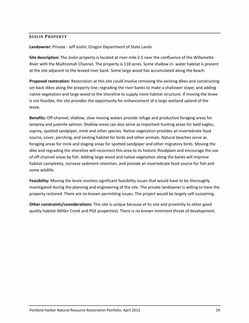
JO S L IN PROP E RT Y
Landowner: Private ‐ Jeff Joslin; Oregon Department of State Lands
Site description: The Joslin property is located at river mile 2.5 near the confluence of the Willamette
River with the Multnomah Channel. The property is 118 acres. Some shallow in‐ water habitat is present
at the site adjacent to the leveed river bank. Some large wood has accumulated along the beach.
Proposed restoration: Restoration at this site could involve removing the existing dikes and constructing
set back dikes along the property line; regrading the river banks to make a shallower slope; and adding
native vegetation and large wood to the shoreline to supply more habitat structure. If moving the levee
is not feasible, the site provides the opportunity for enhancement of a large wetland upland of the
levee.
Benefits: Off‐channel, shallow, slow moving waters provide refuge and productive foraging areas for
lamprey and juvenile salmon. Shallow areas can also serve as important hunting areas for bald eagles,
osprey, spotted sandpiper, mink and other species. Native vegetation provides an invertebrate food
source, cover, perching, and nesting habitat for birds and other animals. Natural beaches serve as
foraging areas for mink and staging areas for spotted sandpiper and other migratory birds. Moving the
dike and regrading the shoreline will reconnect this area to its historic floodplain and encourage the use
of off‐channel areas by fish. Adding large wood and native vegetation along the banks will improve
habitat complexity, increase sediment retention, and provide an invertebrate food source for fish and
some wildlife.
Feasibility: Moving the levee involves significant feasibility issues that would have to be thoroughly
investigated during the planning and engineering of the site. The private landowner is willing to have the
property restored. There are no known permitting issues. The project would be largely self-sustaining.
Other constraints/considerations: This site is unique because of its size and proximity to other good
quality habitat (Miller Creek and PGE properties). There is no known imminent threat of development.
Portland Harbor Natural Resource Restoration Portfolio: April 2012 21
L IN NT O N NE IG HB O RHOO D
Landowner: Linnton Plywood Association, Babcock Land Co LLC, RK Storage & Warehouse Inc., Oregon
Department of State Lands
Site description: The Linnton Neighborhood site is located at river mile 4.6. It is an industrial property
that contains an inactive plywood company. There is shallow water habitat along the shoreline in two
inlets. The shoreline is mostly classified as beach and is generally in good condition. The center of the
site has a particularly high bank consisting of native rock. One section at the north end is rip rap. There is
a strip of trees between the shoreline and the developed upland. Several seasonal streams that once
crossed the property currently run through pipes and culverts.
Proposed restoration: Restoration at this site could include several components: regrading and
revegetating the shoreline to improve the quantity and quality of beach habitat; regrading and adding
wood to increase the quantity and quality of shallow water habitat; “daylighting” the streams that cross
the property to create new tributary habitat; restoring fish and wildlife passage from the site to Forest
Park; excavating nearshore areas to create off‐channel riparian habitat; removing overwater structures
and remnants of industrial buildings; and restoring native vegetation to the site.
Benefits: “Daylighting” the piped streams on this site and restoring passage will provide fish and wildlife
access to shallow, complex habitat, and return floodplain function to this mostly impervious site.
Increased floodplain connectivity also enhances habitat complexity and encourages the use of off‐
channel areas by salmon and lamprey. Shallow areas also serve as important hunting areas for bald
eagles, osprey, spotted sandpiper, mink and other species. Vegetation and wood provide cover and
feeding stations for various species while contributing to improved water quality. Beach habitats sustain
rich invertebrate populations; consequently they are important foraging areas for spotted sandpiper,
mink, salmon and a variety of other organisms.
Feasibility: The land is in private ownership and is currently for sale. There is significant development
pressure, as it is currently zoned for river‐industrial use. Many members of the Linnton community are
strongly supportive of restoration at the site. If off‐channel habitat is developed, it will require a minor
amount of ongoing maintenance.
Other constraints/considerations: The north and south parts of the site are owned by different entities.
It is possible that only half of the site would be restored, though it would be preferable to restore the
whole site. This is a unique site because of the presence of beach habitat and because of the
opportunity to connect to clear, cold water from Forest Park streams.

Portland Harbor Natural Resource Restoration Portfolio: April 2012 23
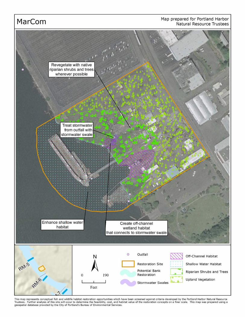
MA RCOM
Landowner: Langley St Johns LLC, Port of Portland, Oregon Department of State Lands
Site description: The MarCom site is located at river mile 5.5 on the east bank of the Willamette River.
The riverbank is classified as beach and accumulates large wood. The north end of the site has been
paved. There is currently good quality beach habitat present at the site. There is limited shallow in‐
water habitat along the shore. The banks and upland area are vegetated sparsely. A boat launch, slag,
and other remains of industry are currently present at the site. Cathedral Park is located just south of
the MarCom site, providing for potential habitat connectivity.
Proposed restoration: Restoration at this site would likely include several components: construction of a
bioswale; creation of off‐channel wetland habitat; revegetation of the entire site with native species;
and removal of infrastructure. Stormwater runoff from upland areas, which currently enters the river
through an outfall, would be treated by the bioswale and the constructed wetlands.
Benefits: Wetlands provide off‐channel, shallow water refuge habitat for salmon and lamprey. Shallow
areas can also serve as important hunting areas for bald eagles, osprey, spotted sandpiper, mink and
other species. Native vegetation will provide food and cover for a variety of species of fish and wildlife,
and perching and nesting opportunities for bald eagle, osprey, and other birds. Treating the stormwater
runoff in the swale and wetland will directly improve water quality.
Feasibility: Department of Environmental Quality‐led remedial actions were scheduled to begin summer
2008; restoration cannot begin until after the remediation is completed. The property is privately owned
and it is unknown if the owner is willing to allow the property to be restored. Minor long‐term
maintenance would be required to manage the stormwater facilities.
Other constraints/considerations: There is already significant wood accumulation and floodplain
habitat at the site. The threat of the site being developed is significant. The north portion of the site has
been purchased by the Port of Portland and the south portion is going through source control with DEQ.
The southern portion of the property is currently for sale.
Portland Harbor Natural Resource Restoration Portfolio: April 2012 25
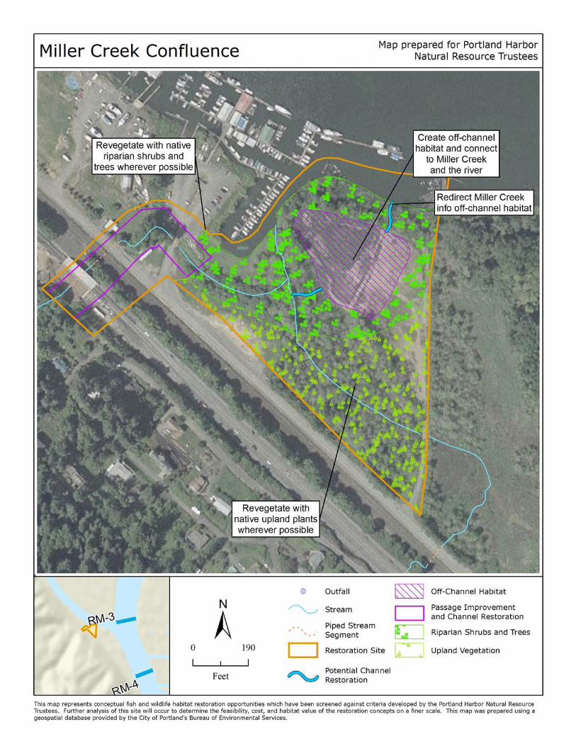
M ILL E R CRE E K CON FLUE N CE
Landowner: Frevach Land Co., Lucky Landing LLC, Oregon Department of State Lands, others
Site description: The Miller Creek site is located at river mile 3.2 along the Multnomah Channel. Miller
Creek itself is routed under a railroad bridge, and then through a series of baffles before becoming a
narrow steep‐sided channel and draining to a marina, which is in an alcove off of Multnomah Channel.
Another creek also flows from the upstream property to the marina. The remainder of the site includes
riparian habitat with vegetation and an area that has been filled. There is also a small stretch of
unclassified shoreline and there appears to be shallow in‐water habitat along the Multnomah Channel.
There is no apparent development in most of the site, except for a portion of the site that extends
across the highway and railroad, and a section of road that leads to the marina.
Proposed restoration: Restoration efforts at this site would likely involve several components: fish and
wildlife passage enhancement in Miller Creek under the railroad tracks; relocation of Miller Creek so
that it flows directly into Multnomah Channel; and addition of large wood and native vegetation along
Miller Creek and throughout all open areas on the site.
Benefits: Realigning the creek, improving passage, and adding native vegetation and large wood will
improve habitat connectivity and quality, enhancing the habitat for salmon, lamprey, sturgeon, and
terrestrial species. Forested areas would provide large trees for perching and nesting opportunities for
bald eagle, osprey and other birds. Creating additional tributary and wetland habitat will increase off‐
channel areas with shallow in‐water habitat used by lamprey and salmon. Shallow areas can also serve
as important hunting areas for bald eagles, osprey, spotted sandpiper, mink and other species. Restoring
the stream and wetland will reconnect this area to its historic floodplain and also enhance habitat
complexity by encouraging the use of off‐channel areas by fish and wildlife.
Feasibility: The land is privately owned and one of the landowners has expressed unwillingness to allow
restoration on the property. There are no known permitting issues. Because of hydrologic changes,
minor on‐going maintenance would be required.
Other constraints/considerations: Miller Creek is unique because the entire upper watershed is well‐
forested, it is one of the least impacted watersheds within the City of Portland, and because it is the only
location where coho salmon are believed to spawn in the Portland Harbor study area.
Portland Harbor Natural Resource Restoration Portfolio: April 2012 27
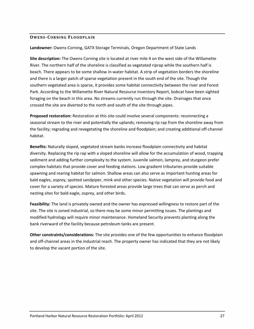
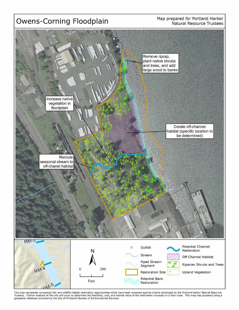
OW E NS‐CORN IN G FL OO D PL A IN
Landowner: Owens‐Corning, GATX Storage Terminals, Oregon Department of State Lands
Site description: The Owens Corning site is located at river mile 4 on the west side of the Willamette
River. The northern half of the shoreline is classified as vegetated riprap while the southern half is
beach. There appears to be some shallow in‐water habitat. A strip of vegetation borders the shoreline
and there is a larger patch of sparse vegetation present in the south end of the site. Though the
southern vegetated area is sparse, it provides some habitat connectivity between the river and Forest
Park. According to the Willamette River Natural Resource Inventory Report, bobcat have been sighted
foraging on the beach in this area. No streams currently run through the site. Drainages that once
crossed the site are diverted to the north and south of the site through pipes.
Proposed restoration: Restoration at this site could involve several components: reconnecting a
seasonal stream to the river and potentially the uplands; removing rip rap from the shoreline away from
the facility; regrading and revegetating the shoreline and floodplain; and creating additional off‐channel
habitat.
Benefits: Naturally sloped, vegetated stream banks increase floodplain connectivity and habitat
diversity. Replacing the rip rap with a sloped shoreline will allow for the accumulation of wood, trapping
sediment and adding further complexity to the system. Juvenile salmon, lamprey, and sturgeon prefer
complex habitats that provide cover and feeding stations. Low gradient tributaries provide suitable
spawning and rearing habitat for salmon. Shallow areas can also serve as important hunting areas for
bald eagles, osprey, spotted sandpiper, mink and other species. Native vegetation will provide food and
cover for a variety of species. Mature forested areas provide large trees that can serve as perch and
nesting sites for bald eagle, osprey, and other birds.
Feasibility: The land is privately owned and the owner has expressed willingness to restore part of the
site. The site is zoned industrial, so there may be some minor permitting issues. The plantings and
modified hydrology will require minor maintenance. Homeland Security prevents planting along the
bank riverward of the facility because petroleum tanks are present.
Other constraints/considerations: The site provides one of the few opportunities to enhance floodplain
and off‐channel areas in the industrial reach. The property owner has indicated that they are not likely
to develop the vacant portion of the site.
Portland Harbor Natural Resource Restoration Portfolio: April 2012 29
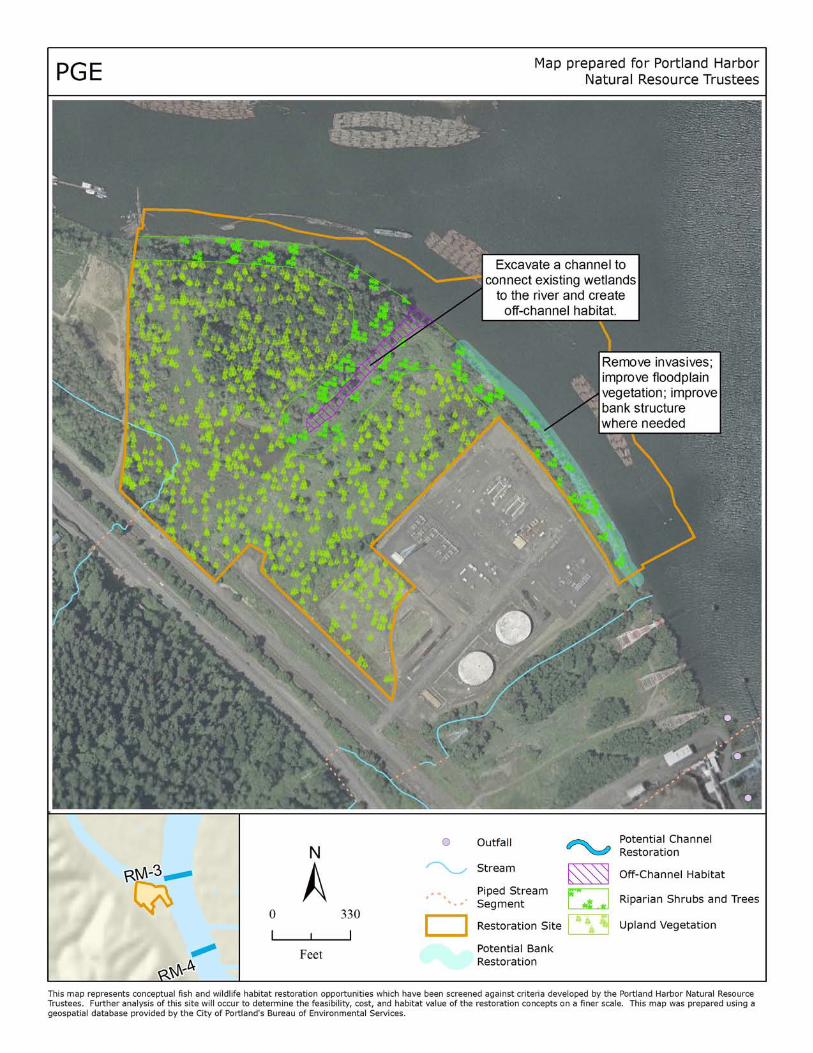
PGE
Landowner: Portland General Electric, Oregon Department of State Lands
Site description: The PGE site is located at river mile 3.2, at the confluence of the Willamette River and
Multnomah Channel. The site contains the Harborton Wetlands, a remnant black cottonwood and ash
floodplain forest wetland area that provides good quality off‐channel habitat, floodplain function, and
habitat connectivity between the river and Forest Park. The banks of these wetlands are natural beach
with some vegetation on the edges. The shoreline appears to transition to shallow in‐water habitat
along the site. The site also contains a small piece of terrestrial habitat that is covered by invasive
vegetation, pavement and structures.
Proposed restoration: Restoration at this site could include several components: excavating from the
river to the middle of the site to connect the wetlands to the river; redirecting the stream running
through the southwest corner of the site to connect with the newly created wetlands; improving the
river bank at the south end of the site; removing invasive plants and replanting native vegetation in the
forested wetland, floodplain, and upland areas; and remove pavement, fill and structures wherever
possible.
Benefits: Off‐channel and tributary waters are some of the most productive rearing sites for salmon.
Shallow areas can also serve as important hunting areas for bald eagles, osprey, spotted sandpiper, mink
and other species. Natural beaches and shallow wetlands also serve as foraging areas for mink and
staging areas for spotted sandpiper and other migratory birds. Native vegetation will provide food and
cover for a variety of species while reducing erosion and enhancing water quality. The structural
diversity, snags, and large wood that may be enhanced in the forested portion of the site provide
valuable habitat complexity for terrestrial species. Revegetation would provide large trees for perching
and nesting opportunities for bald eagle, osprey and other birds.
Feasibility: The land is privately owned and it is anticipated that the owner may be willing to allow
restoration on the property. There are no known permitting issues. The plantings and wetlands would
require minor ongoing maintenance.
Other constraints/considerations: The PGE site is rare because it is an undeveloped site in good
condition. Its location at the confluence of the Willamette River and Multnomah Channel is unique.
There is no known imminent threat of the property being developed. Restoration at this site would need
to be coordinated closely with restoration plans at the adjacent Miller Creek site.
Portland Harbor Natural Resource Restoration Portfolio: April 2012 31
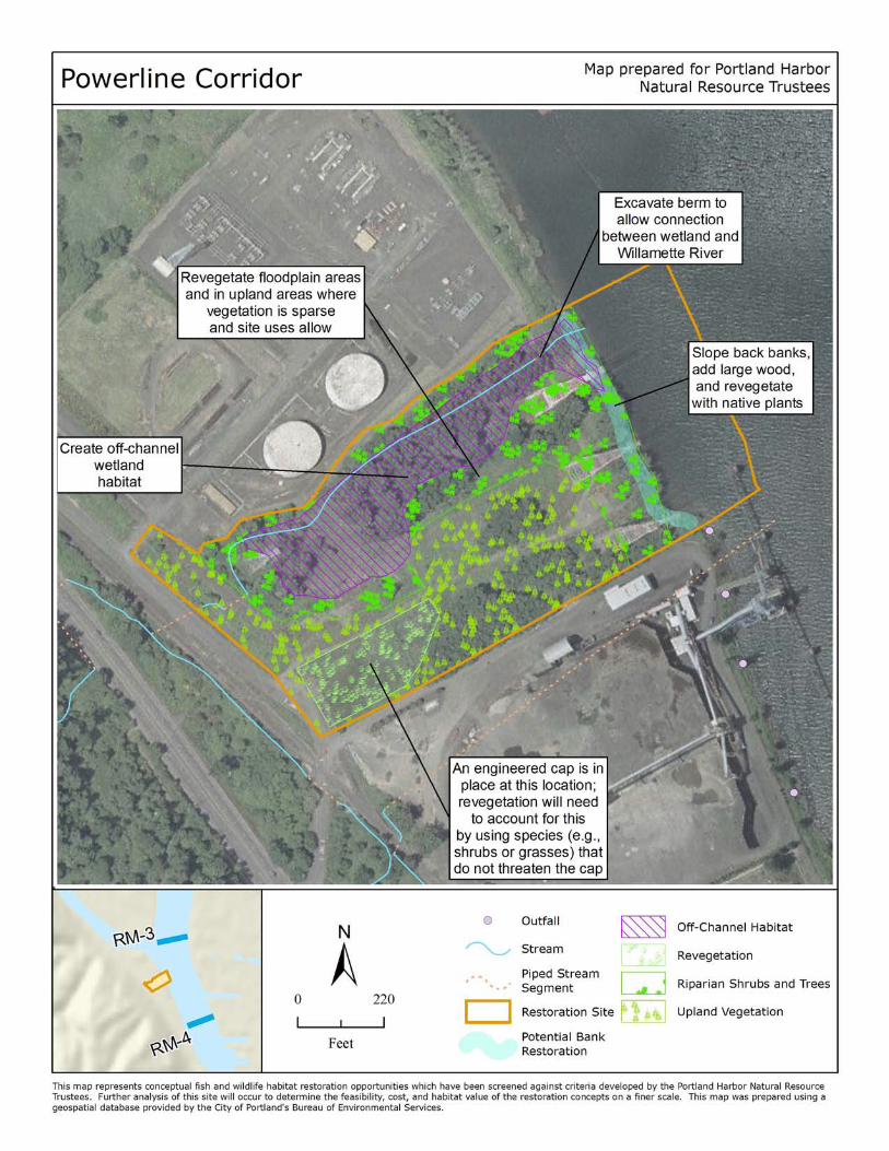
PO W E RL INE CO RRID O R
Landowner: Portland General Electric, US Government powerline easement, Oregon Department of
State Lands
Site description: The Powerline Corridor site is located at river mile 3.4 on the west side of the
Willamette River, just south of Multnomah Channel. An intermittent stream flows down from Forest
Park and through the site. Most of the stream is natural, open channel, except where it flows through
culverts below HWY 30, the railroad, and a service drive close to its confluence with the river. The
stream then flows into a small forested wetland area, which contains trees, shrubs, and herbaceous
vegetation. The wetland is separated from the Willamette River by a raised berm. The shoreline is
vegetated beach, with some apparent shallow in‐water habitat at the north end.
Proposed restoration: Restoration of the site could include removing the berm where the last segment
of the creek is piped; lowering the grade in the bermed area; adding large wood to the stream and
beach; revegetating the floodplain areas with native plant species and removing invasive plants; planting
native trees and shrubs in upland areas; and planting native plants, including wapato, in the wetlands.
Benefits: Off‐channel and tributary waters are some of the most productive rearing sites for salmon.
Shallow areas can also serve as important hunting areas for bald eagles, osprey, spotted sandpiper, mink
and other species. Natural beaches and shallow wetlands also serve as foraging areas for mink and
staging areas for spotted sandpiper and other migratory birds. Large wood creates habitat complexity
for juvenile salmon, lamprey, and sturgeon that use them for cover and feeding stations. Native
vegetation will provide food and cover for a variety of species while reducing erosion and enhancing
water quality. Mature trees will provide perching and nesting opportunities for bald eagle, osprey, and
other birds.
Feasibility: The land is privately owned. There are no known permitting issues. The plantings and
created wetlands would require minor ongoing maintenance.
Other constraints/considerations: The habitat provides a rare opportunity to connect an existing
forested wetland to the Willamette River. The existing beach, wetland, and forest patches already
provide good quality habitat in this heavily developed area; it is important that any restoration plan
includes protection of these functioning habitats. When planting vegetation in the southwest corner of
the site, special consideration must be taken because an engineered cap is in place.
Portland Harbor Natural Resource Restoration Portfolio: April 2012 33
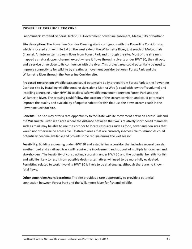
PO W E RL INE CO RRID O R CRO S S ING
Landowners: Portland General Electric, US Government powerline easement, Metro, City of Portland
Site description: The Powerline Corridor Crossing site is contiguous with the Powerline Corridor site,
which is located at river mile 3.4 on the west side of the Willamette River, just south of Multnomah
Channel. An intermittent stream flows from Forest Park and through the site. Most of the stream is
mapped as natural, open channel, except where it flows through culverts under HWY 30, the railroad,
and a service drive close to its confluence with the river. This project area could potentially be used to
improve connectivity for wildlife by creating a movement corridor between Forest Park and the
Willamette River through the Powerline Corridor site.
Proposed restoration: Wildlife passage could potentially be improved from Forest Park to the Powerline
Corridor site by installing wildlife crossing signs along Marina Way (a road with low traffic volume) and
installing a crossing under HWY 30 to allow safe wildlife movement between Forest Park and the
Willamette River. The crossing could follow the location of the stream corridor, and could potentially
improve the quality and availability of aquatic habitat for fish that use the downstream reach in the
Powerline Corridor site.
Benefits: The site may offer a rare opportunity to facilitate wildlife movement between Forest Park and
the Willamette River in an area where the distance between the two is relatively short. Small mammals
such as mink may be able to use the corridor to locate resources such as food, cover and den sites that
would not otherwise be accessible. Upstream areas that are currently inaccessible to salmonids could
potentially become available and provide some refugia during the wet season.
Feasibility: Building a crossing under HWY 30 and establishing a corridor that includes several parcels,
another road and a railroad track will require the involvement and support of multiple landowners and
stakeholders. The feasibility of constructing a crossing under HWY 30 and the potential benefits for fish
and wildlife likely to result from possible design alternatives will need to be more fully evaluated.
Permitting related to work involving HWY 30 is likely to be challenging, although there are no known
fatal flaws.
Other constraints/considerations: The site provides a rare opportunity to provide a potential
connection between Forest Park and the Willamette River for fish and wildlife.
Powerline Corridor Crossing
r
r
r
r
r
RM-4
RM-3
89:n
r
Powerline Corridor Crossing
Powerline Corridor (adjacent site)
89:n Wildlife crossing
Open Channel
Stormwater Pipe or Culvert
r Willamette River Miles
Upland revegetation
Riparian revegetation
Bank enhancement
Off-channel wetland habitat
Wildlife corridor
Railroad Track
Map prepared for Portland Harbor Natural Resource Trustees
This map represents conceptual fish and wildlife habitat restoration opportunities which have been screened against criteria developed by the Portland Harbor Natural Resource Trustees. Further analysis of this site will occur to determine the feasibility, cost, and habitat value of the restoration concepts on a finer scale. This map was prepared, in part, using geospatial databases provided by the City of Portland's Bureau of Environmental Services. (3/18/10)
±0 250
Feet
Build wildlife undercrossing
Install signage along road to promote safe use as wildlife corridor
Enhance vegetation by removing invasive species and planting native species as needed.

Portland Harbor Natural Resource Restoration Portfolio: April 2012 35
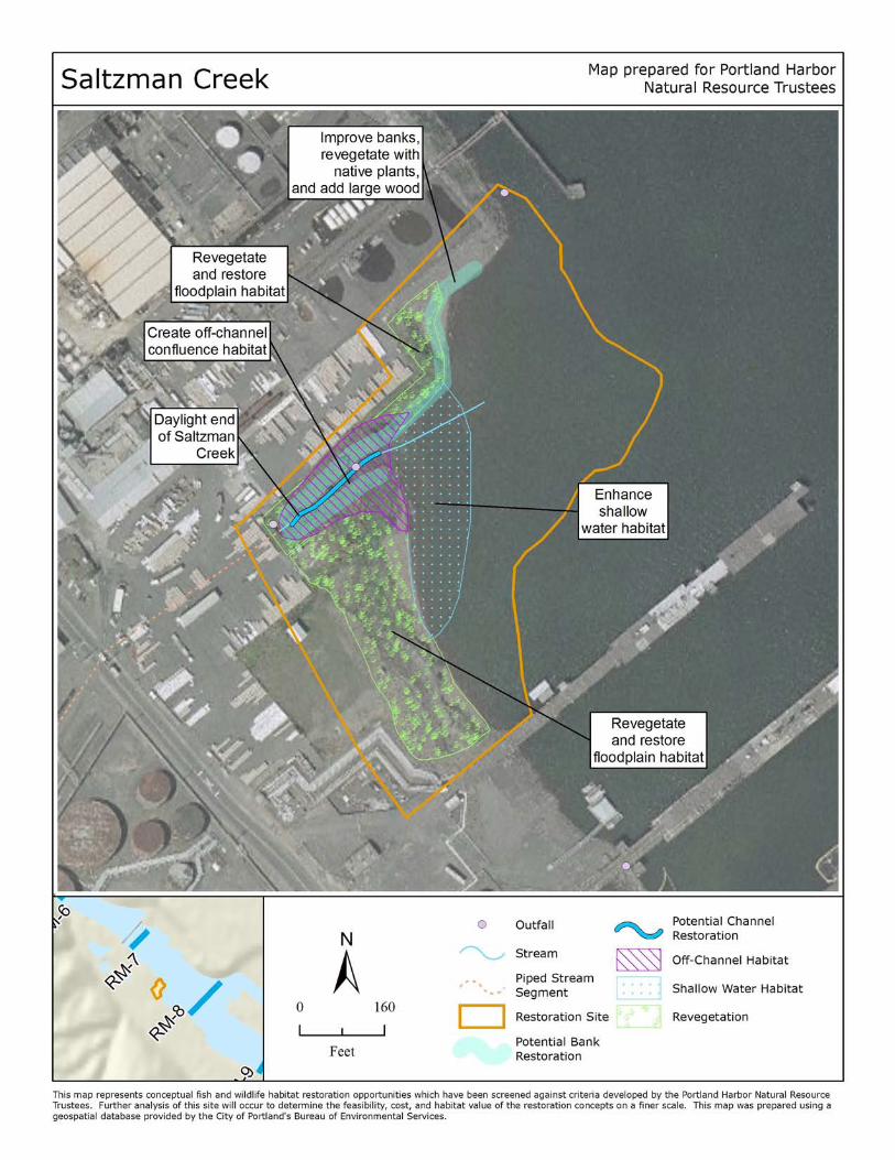
SAL T ZM AN CREE K
Landowner: Genstar Roofing, Kinder‐Morgan, GATX Terminals, Atofina Chemicals, Oregon Department
of State Lands
Site description: The Saltzman Creek site is located at river mile 7.5 on the edge of Willbridge Cove.
Saltzman Creek itself runs in culverts through most of the site. There is a small amount of riparian
vegetation currently on site, and 55.5% of the site is currently impervious. The shoreline contains beach
and mudflat habitat and is in good condition. There appears to be very little shallow in‐water habitat
currently. The site contains some contaminated sediment, which is being at least partially remediated.
Proposed restoration: Restoration at this site could include several components: excavating and
regrading the shoreline to a shallower slope; revegetating the shoreline and river banks with native
riparian vegetation; and adding large wood to the shoreline and river banks.
Benefits: Shallow, low velocity, complex shoreline habitat is crucial for salmon rearing. Shallow areas
can also serve as important hunting areas for bald eagles, osprey, spotted sandpiper, mink and other
species. The habitat structures created by vegetation and wood provide cover and feeding stations for a
variety of species while contributing to improved sediment retention and water quality. Beach habitats
sustain rich invertebrate populations; consequently they are important foraging areas for spotted
sandpiper, mink, and a variety of other organisms.
Feasibility: The extensive storage and transport of petroleum products has the potential to impact
habitat functions, and should be carefully evaluated for potential impacts on restoration and water
quality within Saltzman Creek. There are no known permitting issues. Minor ongoing maintenance
would be required to stabilize new vegetation and modified hydrology.
Other constraints/considerations: The existing confluence area is unique because it provides a cool
water confluence and off‐channel habitat. There is threat of the site of being developed for commercial
or industrial use.
Portland Harbor Natural Resource Restoration Portfolio: April 2012 37
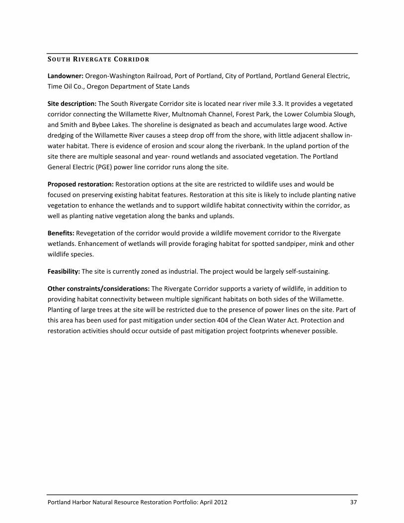
SO UT H R IVE RGA TE CORRID O R
Landowner: Oregon‐Washington Railroad, Port of Portland, City of Portland, Portland General Electric,
Time Oil Co., Oregon Department of State Lands
Site description: The South Rivergate Corridor site is located near river mile 3.3. It provides a vegetated
corridor connecting the Willamette River, Multnomah Channel, Forest Park, the Lower Columbia Slough,
and Smith and Bybee Lakes. The shoreline is designated as beach and accumulates large wood. Active
dredging of the Willamette River causes a steep drop off from the shore, with little adjacent shallow in‐
water habitat. There is evidence of erosion and scour along the riverbank. In the upland portion of the
site there are multiple seasonal and year‐ round wetlands and associated vegetation. The Portland
General Electric (PGE) power line corridor runs along the site.
Proposed restoration: Restoration options at the site are restricted to wildlife uses and would be
focused on preserving existing habitat features. Restoration at this site is likely to include planting native
vegetation to enhance the wetlands and to support wildlife habitat connectivity within the corridor, as
well as planting native vegetation along the banks and uplands.
Benefits: Revegetation of the corridor would provide a wildlife movement corridor to the Rivergate
wetlands. Enhancement of wetlands will provide foraging habitat for spotted sandpiper, mink and other
wildlife species.
Feasibility: The site is currently zoned as industrial. The project would be largely self-sustaining.
Other constraints/considerations: The Rivergate Corridor supports a variety of wildlife, in addition to
providing habitat connectivity between multiple significant habitats on both sides of the Willamette.
Planting of large trees at the site will be restricted due to the presence of power lines on the site. Part of
this area has been used for past mitigation under section 404 of the Clean Water Act. Protection and
restoration activities should occur outside of past mitigation project footprints whenever possible.
Portland Harbor Natural Resource Restoration Portfolio: April 2012 39
ST EEL HA MM E R
Landowner: Steel Hammer Properties, LLC, Oregon Department of State Lands (note: could expand to
parcel across street)
Site description: This site includes two parcels that are 9.23 and 1.25 acres in size, totaling 10.48 acres.
It is located between the Portland Water Pollution Lab by Cathedral Park and Willamette Cove. The site
appears to be filled and graded. The majority of the site has been paved and is used as an outside
storage area for steel products. There are no buildings or other structures on the site. Beach habitat
with large woody debris and vegetation on the shoreline looks fairly natural from aerial photos,
although large rock and boulders have been used to armor the bank, which is steeply sloped. About a
quarter of the area is in the 100-year floodplain according to MetroMap.
Proposed restoration: Riparian, upland, and potentially shoreline and floodplain habitats at the site
could be restored by removing pavement and fill material, regrading or benching the banks, improving
soils and revegetating with native species. Snags and additional large wood could be installed to provide
structure that would further enhance the value of native habitat.
Benefits: Habitat at the site is currently limited to the beach and narrow riparian corridor along the
shoreline. Vegetation could be restored to provide a more functional riparian zone and associated
upland habitat. The banks could be sloped back or benched to increase the flood capacity and frequency
of flooding on the site, and to facilitate growth of riparian vegetation. The site is in a prime location to
improve connectivity between publicly-protected greenspaces (i.e., Cathedral Park and Willamette
Cove) and provide additional habitat where there are very few remnants. Larger, well-connected
habitats better support wildlife populations than smaller isolated habitats by providing more resources,
supporting larger numbers of individuals, and facilitating genetic interchange. Mature trees and snags at
the site could provide perching opportunities for bald eagle and osprey. The beach and shallow water
habitats at this site could be used by spotted sandpiper and salmonids. Other birds, mammals, reptiles
and amphibians are also likely to use the site.
Feasibility: Sandblasting grit and PCBs may occur on the site, and are contaminant concerns that should
be further evaluated and addressed as needed.
Other constraints/considerations: The Clean Water Act, Section 404 permit history could be researched
to see if there is a wetland restoration opportunity at the site. Portland Parks and Recreation has
expressed interest in potential bank work adjacent to the Greenway Trail, but the site has not been
identified for its restoration potential in the City’s draft River Plan (as of 11/09). The site is adjacent to
the Portland Water Pollution Lab; there may be interest in expanding public use into this site if and
when restoration or a land use change occurs.
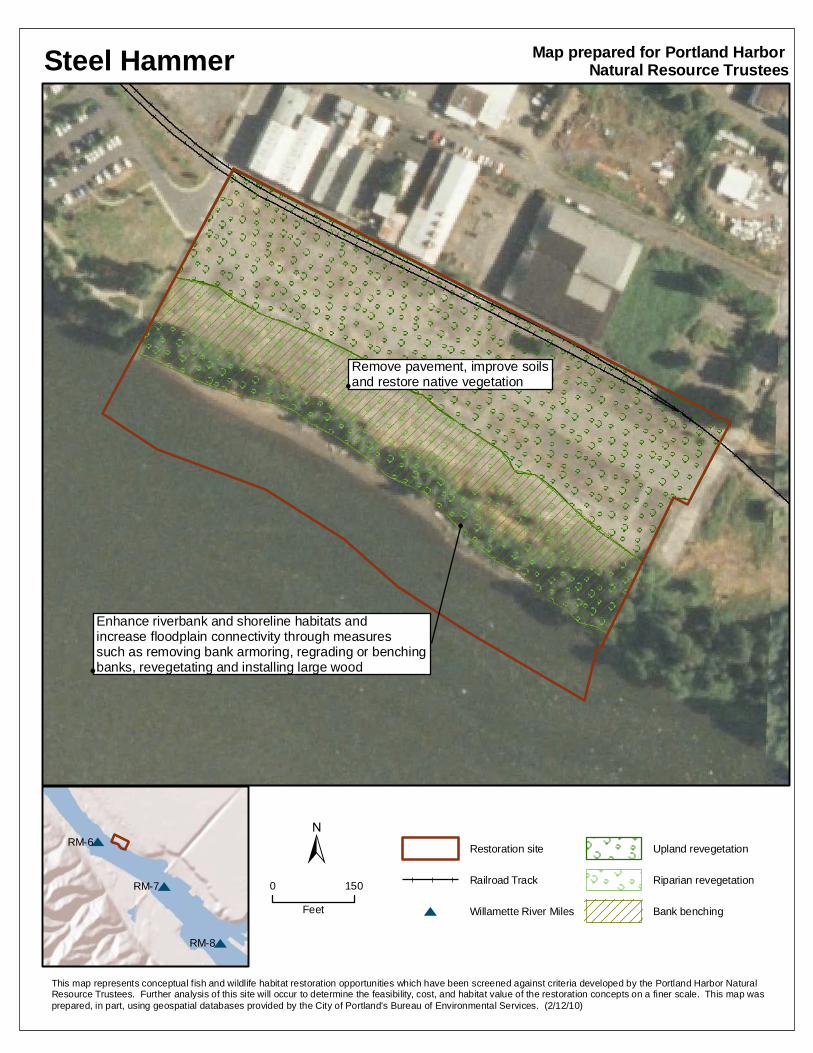
Steel Hammer
r
r
r
r
r
RM-8
RM-7
RM-6
r
Remove pavement, improve soils and restore native vegetation
Enhance riverbank and shoreline habitats and increase floodplain connectivity through measures such as removing bank armoring, regrading or benching banks, revegetating and installing large wood
Restoration site
Railroad Track
r Willamette River Miles
Upland revegetation
Riparian revegetation
Bank benching
Map prepared for Portland Harbor Natural Resource Trustees
This map represents conceptual fish and wildlife habitat restoration opportunities which have been screened against criteria developed by the Portland Harbor Natural Resource Trustees. Further analysis of this site will occur to determine the feasibility, cost, and habitat value of the restoration concepts on a finer scale. This map was prepared, in part, using geospatial databases provided by the City of Portland's Bureau of Environmental Services. (2/12/10)
±0 150
Feet
Portland Harbor Natural Resource Restoration Portfolio: April 2012 41
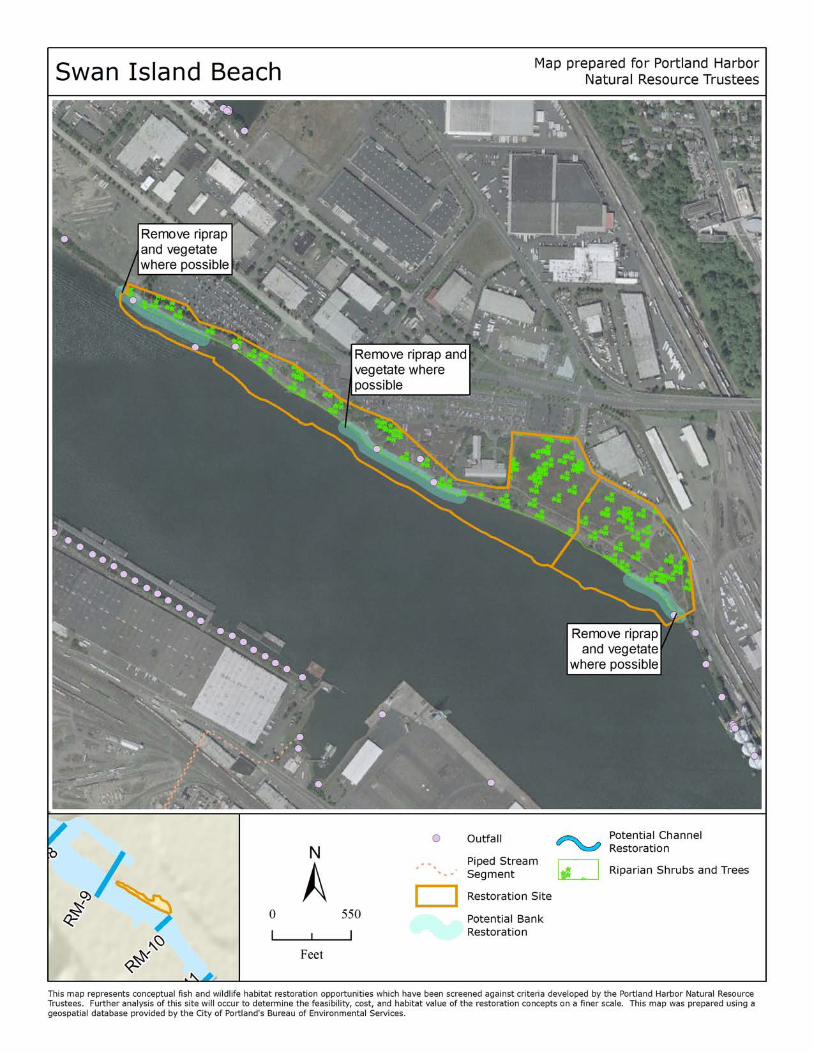
SW A N ISLAN D BEA C H NO RT H
Landowner: Port of Portland, Oregon Department of State Lands
Site description: The Swan Island Beach North site is located at river mile 9.5. Swan Island is a heavily
developed and active industrial area. There are two segments of the site’s shoreline classified as beach
with adjacent shallow water habitat. These vegetated beaches appear to be in good condition and are
known to accumulate large wood, an uncommon occurrence within Portland Harbor. These beach areas
are interspersed among banks treated with vegetated rip rap. There is a strip of shrubs and trees
separating the shoreline from the developed upland.
Proposed restoration: Restoration at this site would likely involve several components: removing rip rap
from the river bank; replanting the river bank where possible with native vegetation; and regrading the
stream bank and shoreline to create shallow in‐water habitat.
Benefits: Beach habitats sustain rich invertebrate populations; consequently they are important
foraging areas for spotted sandpiper, mink, and a variety of other organisms. Naturally sloped,
vegetated stream banks increase floodplain connectivity and habitat diversity. Replacing the rip rap with
a sloped shoreline will allow for the additional accumulation of wood, adding further complexity to the
system. Juvenile salmon, lamprey, and sturgeon prefer complex habitats that provide cover and feeding
stations. Shallow areas serve as important hunting areas for bald eagles, osprey, spotted sandpiper,
mink and other species. Native vegetation will provide food and cover for a variety of species and could
include the addition of perch and nesting sites for bald eagle, osprey and other native birds.
Feasibility: There are no known permitting issues. The project itself would be largely self-sustaining and
require little maintenance.
Other constraints/considerations: Restoration potential at this site is highly constrained by developed
uplands.

Portland Harbor Natural Resource Restoration Portfolio: April 2012 43
SW A N ISLAN D BEA C H SO UT H
Landowner: City of Portland, Oregon Department of State Lands
Site description: The Swan Island Beach South site is located at river mile 9.75 on the east side of the
Willamette River. Swan Island is a heavily developed and active industrial area. Half of the shoreline is
classified as beach with adjacent shallow water habitat. This vegetated beach appears to be in good
condition and is known to accumulate large wood. The other half of the shoreline is treated with
vegetated rip rap or unclassified fill. The riverbank slopes are extremely steep. There is a strip of shrubs
and trees separating the riverbank from the developed upland.
Proposed restoration: Restoration at this site could involve removing rip rap from the river bank;
replanting the river bank and floodplain with native vegetation; and excavating and regrading the
shoreline to increase the amount of floodplain, flood storage, and shallow water habitat.
Benefits: Beach habitats sustain rich invertebrate populations; consequently they are important
foraging areas for spotted sandpiper, mink, and a variety of other organisms. Naturally sloped,
vegetated stream banks increase floodplain connectivity and habitat diversity. Replacing the rip rap with
a sloped shoreline will allow for the accumulation of wood, adding further complexity and sediment
retention to the system. Juvenile salmon, lamprey, and sturgeon prefer complex habitats that provide
cover and feeding stations. Shallow areas serve as important hunting areas for bald eagles, osprey,
spotted sandpiper, mink and other species. Native vegetation will provide food and cover for a variety of
species and could include the addition of perch and nesting sites for bald eagle, osprey and other native
birds.
Feasibility: The site is in public ownership. There are no known permitting issues. The project itself
would be largely self-sustaining and require little maintenance.
Other constraints/considerations: The site currently accumulates wood. Altering the bank slopes would
require moving the greenway trail.
Portland Harbor Natural Resource Restoration Portfolio: April 2012 45
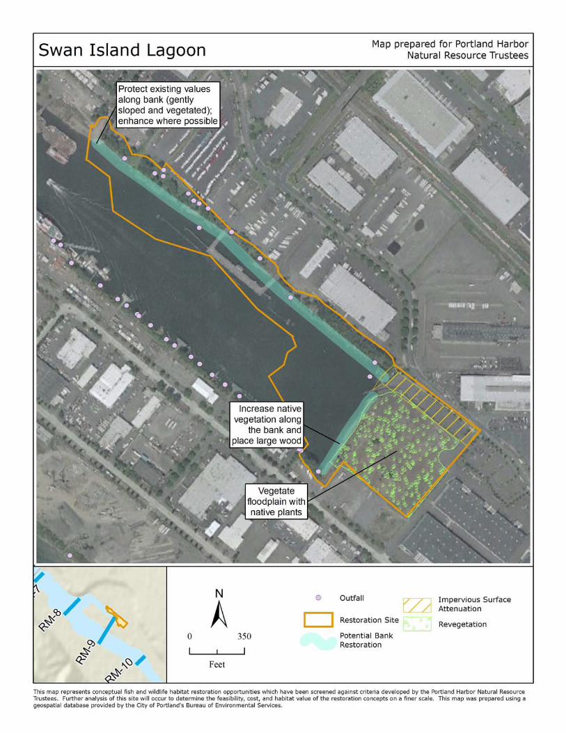
SW A N ISLAN D LAG O O N
Landowner: City of Portland, Port of Portland, Anchor Park LLC, ATC Leasing Co., Becker Land LLC, North
Basin Watumull LLC, Oregon Department of State Lands
Site description: The Swan Island Lagoon site begins at river mile 9 and is a heavily developed, active
industrial area. Riparian cover along the banks is fragmented by active river industrial uses (including
boat ramps and docks), and some rip rap. Some areas of the bank support a well-established stand of
black cottonwoods. A beach area at the end of the lagoon is associated with a wetland that potentially
contains wapato vegetation. Invasive vegetation dominates much of the shoreline, particularly in a
vacant parcel at the southeast end. There is shallow water habitat along the shores and at the end of the
lagoon.
Proposed restoration: Restoration at the lagoon site would be focused on the vacant lot at the end of
the lagoon and could include improving the bank by removing rip rap and invasive plants; protecting and
enhancing native vegetation; improving shallow water habitat by adding large wood; excavating the
floodplain to create a seasonal wetland; and treating stormwater runoff from the parking lots and boat
ramp before it enters the lagoon. Protecting the existing stand of cottonwood trees along the side of the
lagoon could also be a priority.
Benefits: Beach habitats sustain rich invertebrate populations; consequently they are important
foraging areas for spotted sandpiper, mink, and a variety of other organisms. Naturally sloped,
vegetated stream banks increase floodplain connectivity and habitat diversity. Juvenile salmon, lamprey,
and sturgeon prefer complex habitats that provide cover and feeding stations. Off‐channel, shallow,
slow moving waters like lagoons gather wood and provide refuge and productive foraging areas for
lamprey and juvenile salmon. The seasonal wetland would also provide shelter and a prey source for
lamprey and salmon. Shallow areas can also serve as important hunting areas for bald eagles, osprey,
spotted sandpiper, mink and other species. Native vegetation will provide food and cover for a variety of
species. Treating the stormwater runoff will directly improve water quality in the lagoon.
Feasibility: Some contamination cleanup will be necessary before restoration begins. The property is
owned by a variety of entities, both public and private. There are no known permitting issues.
Restoration efforts would require minor maintenance for plantings and hydrology.
Other constraints/considerations: The Swan Island Lagoon is the largest off‐channel area in the
industrial reach. The existing beach habitat is a unique feature in the area. Boat launches create a
challenge for maintaining habitat values. The opportunity to restore the floodplain portion of this site
may be lost if the City sells its land.
Portland Harbor Natural Resource Restoration Portfolio: April 2012 47
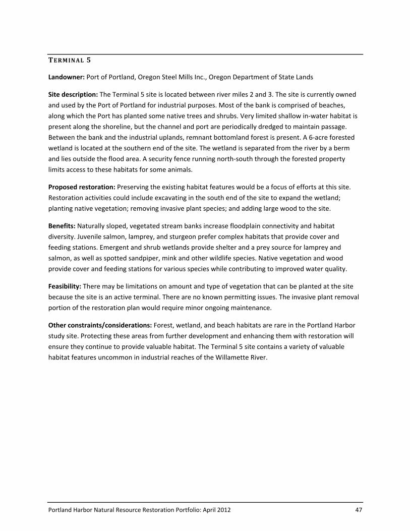
TE RM IN AL 5
Landowner: Port of Portland, Oregon Steel Mills Inc., Oregon Department of State Lands
Site description: The Terminal 5 site is located between river miles 2 and 3. The site is currently owned
and used by the Port of Portland for industrial purposes. Most of the bank is comprised of beaches,
along which the Port has planted some native trees and shrubs. Very limited shallow in‐water habitat is
present along the shoreline, but the channel and port are periodically dredged to maintain passage.
Between the bank and the industrial uplands, remnant bottomland forest is present. A 6‐acre forested
wetland is located at the southern end of the site. The wetland is separated from the river by a berm
and lies outside the flood area. A security fence running north‐south through the forested property
limits access to these habitats for some animals.
Proposed restoration: Preserving the existing habitat features would be a focus of efforts at this site.
Restoration activities could include excavating in the south end of the site to expand the wetland;
planting native vegetation; removing invasive plant species; and adding large wood to the site.
Benefits: Naturally sloped, vegetated stream banks increase floodplain connectivity and habitat
diversity. Juvenile salmon, lamprey, and sturgeon prefer complex habitats that provide cover and
feeding stations. Emergent and shrub wetlands provide shelter and a prey source for lamprey and
salmon, as well as spotted sandpiper, mink and other wildlife species. Native vegetation and wood
provide cover and feeding stations for various species while contributing to improved water quality.
Feasibility: There may be limitations on amount and type of vegetation that can be planted at the site
because the site is an active terminal. There are no known permitting issues. The invasive plant removal
portion of the restoration plan would require minor ongoing maintenance.
Other constraints/considerations: Forest, wetland, and beach habitats are rare in the Portland Harbor
study site. Protecting these areas from further development and enhancing them with restoration will
ensure they continue to provide valuable habitat. The Terminal 5 site contains a variety of valuable
habitat features uncommon in industrial reaches of the Willamette River.
Portland Harbor Natural Resource Restoration Portfolio: April 2012 49
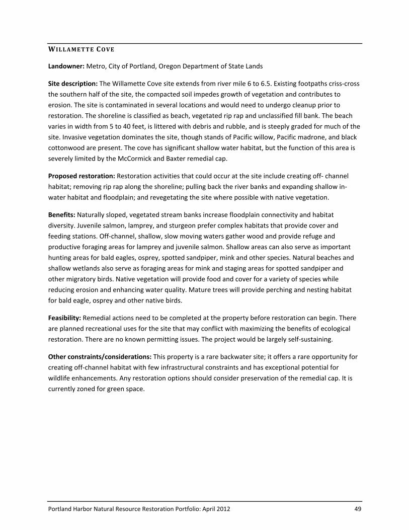
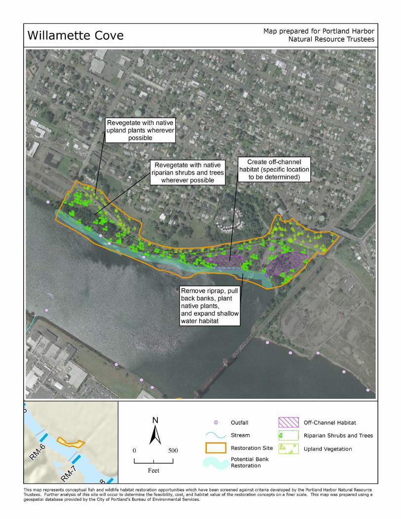
W IL LA METT E CO VE
Landowner: Metro, City of Portland, Oregon Department of State Lands
Site description: The Willamette Cove site extends from river mile 6 to 6.5. Existing footpaths criss‐cross
the southern half of the site, the compacted soil impedes growth of vegetation and contributes to
erosion. The site is contaminated in several locations and would need to undergo cleanup prior to
restoration. The shoreline is classified as beach, vegetated rip rap and unclassified fill bank. The beach
varies in width from 5 to 40 feet, is littered with debris and rubble, and is steeply graded for much of the
site. Invasive vegetation dominates the site, though stands of Pacific willow, Pacific madrone, and black
cottonwood are present. The cove has significant shallow water habitat, but the function of this area is
severely limited by the McCormick and Baxter remedial cap.
Proposed restoration: Restoration activities that could occur at the site include creating off‐ channel
habitat; removing rip rap along the shoreline; pulling back the river banks and expanding shallow in‐
water habitat and floodplain; and revegetating the site where possible with native vegetation.
Benefits: Naturally sloped, vegetated stream banks increase floodplain connectivity and habitat
diversity. Juvenile salmon, lamprey, and sturgeon prefer complex habitats that provide cover and
feeding stations. Off‐channel, shallow, slow moving waters gather wood and provide refuge and
productive foraging areas for lamprey and juvenile salmon. Shallow areas can also serve as important
hunting areas for bald eagles, osprey, spotted sandpiper, mink and other species. Natural beaches and
shallow wetlands also serve as foraging areas for mink and staging areas for spotted sandpiper and
other migratory birds. Native vegetation will provide food and cover for a variety of species while
reducing erosion and enhancing water quality. Mature trees will provide perching and nesting habitat
for bald eagle, osprey and other native birds.
Feasibility: Remedial actions need to be completed at the property before restoration can begin. There
are planned recreational uses for the site that may conflict with maximizing the benefits of ecological
restoration. There are no known permitting issues. The project would be largely self-sustaining.
Other constraints/considerations: This property is a rare backwater site; it offers a rare opportunity for
creating off‐channel habitat with few infrastructural constraints and has exceptional potential for
wildlife enhancements. Any restoration options should consider preservation of the remedial cap. It is
currently zoned for green space.
Portland Harbor Natural Resource Restoration Portfolio: April 2012 51
Restoration Sites in the Broader Focus Area
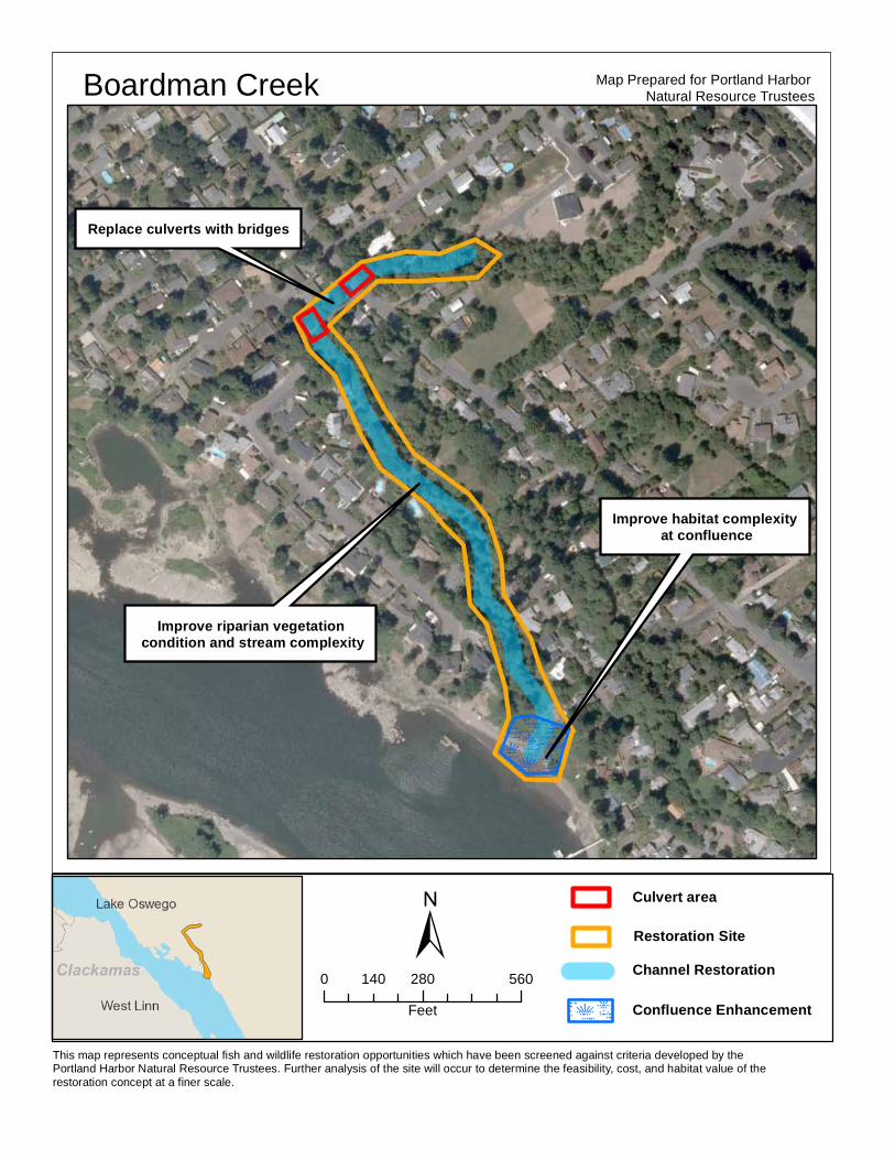
BO A RDM AN CREE K
Landowner: Private property owners, Beaverbrook Homeowners Association, Oak Lodge Sanitary
District, Oregon Department of State Lands
Site Description: Boardman Creek meets the Willamette River near River Mile 23 on the east side of the
river. The 13,000 foot creek runs through a highly urbanized part of Clackamas County, including the
towns of Jennings Lodge and Gladstone, Oregon. There are currently three deteriorating culverts at the
downstream end of Boardman Creek, about 1000 feet from its confluence with the Willamette River.
Two of the culverts are located at the same crossing under River Road and the third culvert is buried
beneath Walta Vista Court. Salmon and steelhead have been documented just downstream of the
undersized culverts, which form a complete fish passage barrier. The riparian areas between the
culverts and down to the confluence area are degraded, further limiting the water quality and habitat
within the stream.
Proposed Restoration: Restoration at the site would include removing the culverts and replacing them
with two single-span bridges. Restoration would also include enhancing the 300 feet of riparian habitat
between the culverts and looking for opportunities to enhance riparian habitat and instream habitat
complexity downstream to and including the confluence with the Willamette River. Replacing the
Boardman Creek culverts will open 6000 feet of stream to fish and wildlife passage from the Willamette
River up to McLoughlin Boulevard.
Benefits: This project would allow access for threatened and endangered salmonids as well as lamprey,
and improve connectivity for mink and other wildlife species to over a mile of tributary habitat. This
project will also improve instream habitat quality and complexity, improve access to off-channel habitat
as refuge from the Willamette River during high flows, improve floodplain connectivity, and improve
riparian habitat by restoring native vegetation. The riparian buffer will also improve water quality at the
site.
Feasibility: The site includes a mix of public and private ownerships, so coordination among the various
landowners will be necessary. The Oak Lodge Sanitary District has already completed an alternatives
analysis and preliminary engineering work for the project and has chosen replacing the three culverts
with two single span bridges as the most appropriate solution for fish and wildlife, flooding, and
infrastructure concerns at the site.
Other Constraints/Considerations: The Oak Lodge Sanitary District was recently awarded a Nature in
Neighborhoods Grant from Metro to finance part of the project
This map represents conceptual fish and wildlife restoration opportunities which have been screened against criteria developed by the Portland Harbor Natural Resource Trustees. Further analysis of the site will occur to determine the feasibility, cost, and habitat value of the restoration concept at a finer scale.
Culvert area
Restoration SiteChannel Restoration
±
Map Prepared for Portland Harbor Natural Resource TrusteesBoardman Creek
Replace culverts with bridges
Improve riparian vegetation condition and stream complexity
Improve habitat complexity at confluence
0 280 560140Feet Confluence Enhancement
Portland Harbor Natural Resource Restoration Portfolio: April 2012 53
CED A R ISL AN D A ND MAIN LA ND
Landowner: City of West Linn, Oregon Department of State Lands
Site Description: Cedar Oak Park, which contains a public boat ramp maintained by the City of West
Linn, is located on the west side of the Willamette River at River Mile 23. The park contains a 4-acre
riparian forest with a relatively intact overstory. The park also contains approximately 1,600 linear feet
of gently sloping beach along the west shore of the Willamette. Cedar Island is located in the
Willamette River adjacent to the park. The island was extensively mined in the past for sand and gravel,
and is currently a 14-acre horseshoe-shaped island around a 20-acre central lagoon open at the
downriver end. Most of the lagoon is 20 feet deep, though there is a central high spot that is only 15
feet deep, and a small hole that is 35 feet deep.
The City of West Linn purchased the island in the early 1990’s, restored native habitat, and installed
underwater structures in the lagoon for warm-water fish (i.e., bass, crappie, bluegill) habitat. The
eastern arm of the island was developed for passive recreation, with trails and fishing platforms
overhanging the lagoon. A seasonal footbridge connects the upper end of the island to the adjoining
mainland at Mary S. Young State Park. The western arm was restored for native habitat only, with the
intent of limiting recreational access near residential development. Since the mid-1990’s, invasive
vegetation has reclaimed much of the island.
Proposed Restoration: Riparian habitat could be restored on Cedar Island and on the mainland at Cedar
Oak Park, including invasive species removal and native plantings. Removal of the existing in-water
structures would reduce habitat for invasive warm water fish. Habitat complexity could be enhanced on
the beaches along the main and side channels.
Benefits: Adding complexity to the beaches in the Cedar Island lagoon would provide refugia and habitat
for migrating salmonids (particularly juveniles) and other native fish species. Removing the existing in-
water structures from the lagoon would reduce habitat for invasive warm-water piscivores.
Restoring the native riparian plant community on the island would provide valuable feeding and
breeding habitat for native terrestrial wildlife species as well as migratory birds and promote
connectivity to other habitats near the confluence of the Willamette and Clackamas Rivers. In addition,
a healthy native riparian vegetation community stabilizes stream banks, reduces and/or captures
sediment flows, cycles nutrients and provides a source of large wood for adjacent and downstream
areas.
Feasibility: The island and park are publicly owned and managed by the City of West Linn Parks &
Recreation Department. A 1992 site assessment concluded that there was “no indication” of significant
soil and/or groundwater contamination.

54 Portland Harbor Natural Resource Restoration Portfolio: April 2012
Other constraints/considerations: Annual high water events present engineering challenges and liability
concerns for habitat elements like large woody debris.
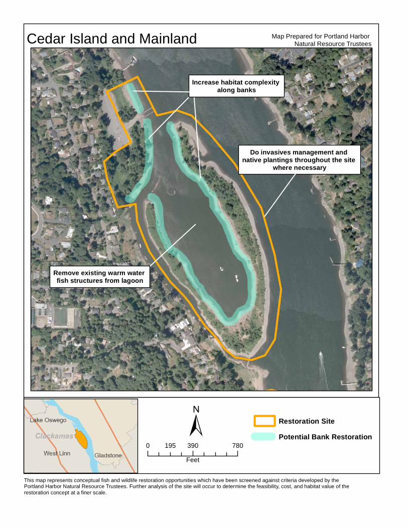
This map represents conceptual fish and wildlife restoration opportunities which have been screened against criteria developed by the Portland Harbor Natural Resource Trustees. Further analysis of the site will occur to determine the feasibility, cost, and habitat value of the restoration concept at a finer scale.
±
Map Prepared for Portland Harbor Natural Resource TrusteesCedar Island and Mainland
Increase habitat complexity along banks
Remove existing warm water fish structures from lagoon
Do invasives management and native plantings throughout the site
where necessary
0 390 780195Feet
Restoration SitePotential Bank Restoration
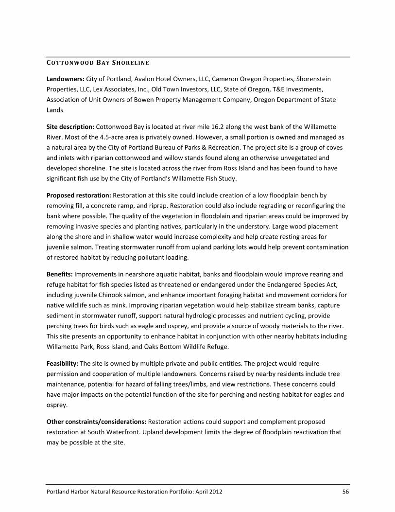
Portland Harbor Natural Resource Restoration Portfolio: April 2012 56
CO T T ON W OO D BAY SHO REL INE
Landowners: City of Portland, Avalon Hotel Owners, LLC, Cameron Oregon Properties, Shorenstein
Properties, LLC, Lex Associates, Inc., Old Town Investors, LLC, State of Oregon, T&E Investments,
Association of Unit Owners of Bowen Property Management Company, Oregon Department of State
Lands
Site description: Cottonwood Bay is located at river mile 16.2 along the west bank of the Willamette
River. Most of the 4.5-acre area is privately owned. However, a small portion is owned and managed as
a natural area by the City of Portland Bureau of Parks & Recreation. The project site is a group of coves
and inlets with riparian cottonwood and willow stands found along an otherwise unvegetated and
developed shoreline. The site is located across the river from Ross Island and has been found to have
significant fish use by the City of Portland’s Willamette Fish Study.
Proposed restoration: Restoration at this site could include creation of a low floodplain bench by
removing fill, a concrete ramp, and riprap. Restoration could also include regrading or reconfiguring the
bank where possible. The quality of the vegetation in floodplain and riparian areas could be improved by
removing invasive species and planting natives, particularly in the understory. Large wood placement
along the shore and in shallow water would increase complexity and help create resting areas for
juvenile salmon. Treating stormwater runoff from upland parking lots would help prevent contamination
of restored habitat by reducing pollutant loading.
Benefits: Improvements in nearshore aquatic habitat, banks and floodplain would improve rearing and
refuge habitat for fish species listed as threatened or endangered under the Endangered Species Act,
including juvenile Chinook salmon, and enhance important foraging habitat and movement corridors for
native wildlife such as mink. Improving riparian vegetation would help stabilize stream banks, capture
sediment in stormwater runoff, support natural hydrologic processes and nutrient cycling, provide
perching trees for birds such as eagle and osprey, and provide a source of woody materials to the river.
This site presents an opportunity to enhance habitat in conjunction with other nearby habitats including
Willamette Park, Ross Island, and Oaks Bottom Wildlife Refuge.
Feasibility: The site is owned by multiple private and public entities. The project would require
permission and cooperation of multiple landowners. Concerns raised by nearby residents include tree
maintenance, potential for hazard of falling trees/limbs, and view restrictions. These concerns could
have major impacts on the potential function of the site for perching and nesting habitat for eagles and
osprey.
Other constraints/considerations: Restoration actions could support and complement proposed
restoration at South Waterfront. Upland development limits the degree of floodplain reactivation that
may be possible at the site.
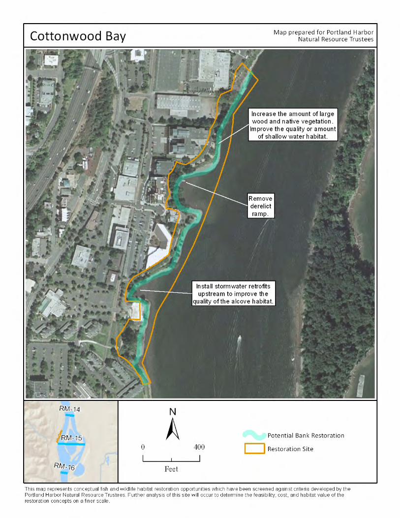
58 Portland Harbor Natural Resource Restoration Portfolio: April 2012
EL K RO C K IS LA ND/SP RIN G PA RK
Landowner: City of Milwaukie (Spring Park); City of Portland, GRS Properties, DLS Properties and other
private owners (Elk Rock Island), Oregon Department of State Lands
Site description: Spring Park is a 6-acre site located on the east bank of the Willamette River at
approximately river mile 19. Spring Park is largely undeveloped and is currently maintained by the North
Clackamas Parks and Recreation District (NCPRD) as a natural area. A large unmapped wetland is located
in its center, and the remainder of the site is composed of riparian forest and grasslands. Portions of the
site are composed of geologically significant bedrock. A large population of invasive species, including
blackberry, knotweed, clematis, English hawthorn, reed canary grass, common tansy, English ivy and
Norway maple, currently inhabit the site.
Elk Rock Island is a 15-acre island park located in the main channel of the Willamette River at river mile
18.9. The island is accessible by foot at low water from Spring Park and by boat at all river levels. The
island contains exposed rock, emergent wetlands, and riparian and upland forest which provide diverse
habitats for a wide range of bird, mammal, reptile, amphibian and invertebrate species. Plants rare to
the Portland metro area that may occur on the island include Pacific yew, Tiger lily, Cluster lily and
Rattlesnake plantain. Oregon white oak woodlands and savanna habitats are also present on the island.
Dominant tree species are black cottonwood, bigleaf maple, Douglas fir, and Oregon white oak.
Proposed restoration: Restoration at this site could include placement of large wood on the banks and
shallow water areas. Acquisition of properties or easements along the off-channel alcove would allow
for enhancement of this habitat. Rock outcrop and riparian vegetation could also be protected and
improved. Removal of invasive species and planting native vegetation, which would improve remnant
oak habitat, is also a possibility. The Spring Park path system which currently traverses the wetland
habitat in the park could be relocated out of the wetland or elevated to protect and improve wetland
function and natural hydrologic flow.
Benefits: This project will improve water quality through increased canopy cover and decreasing
sedimentation caused by overuse. Establishing a healthy tree canopy will decrease water and soil
temperatures, provide perching and possible nesting areas for birds such as osprey and bald eagles, and
increase large woody debris recruitment over time. Re-routing or improving the user-created path at
Spring Park out of the large wetland area in the middle of the site will improve habitat for wetland plant
and wildlife species. Placement of large woody debris will increase habitat structure on the beach and in
shallow water areas. Invasive species removal and native revegetation and protection will increase the
habitat value of upland forest areas.
Feasibility: Private ownership of portions of Elk Rock Island would require permission and coordination
from multiple landowners. Restoration work at Spring Park would require the project to be approved
through a land use planning process at the City of Milwaukie.

Portland Harbor Natural Resource Restoration Portfolio: April 2012 59
Other constraints/considerations: A high level of human disturbance would limit the ecological benefits
of the project to fish and wildlife.
Portland Harbor Natural Resource Restoration Portfolio: April 2012 61
HO L GA TE SL O UG H
Landowners: Metro, City of Portland, Ross Island Sand and Gravel, Portland Transit Company, Oregon
Department of Transportation, Union Pacific Railroad Co., Oregon Department of State Lands, private
property owners
Site description: Holgate Slough is located at river mile 14.2 along the east bank of the Willamette River,
on the east side of Ross Island. As the only true side-channel in the area, Holgate Slough is an important
component of the Oaks Bottom-Ross Island complex, one of the most diverse habitat complexes within
the lower river with an extensive amount of shallow water and off-channel habitat. The site varies in
width, and is constrained in some areas. In the more constrained areas, banks are unstable. In other
areas, overhanging banks and vegetation are stable. Debris litters parts of the site. Mature riparian trees
and a mix of native and non-native understory plants are the dominant vegetation type in the project
area.
Proposed restoration: Proposed restoration at this site includes improving bank composition where
banks have been eroded and steepened, to provide better habitat for fish species and to improve water
quality. Protecting banks from boat wakes will maintain restored habitat in the long term. In addition,
bank work would increase the connectivity of the floodplain within the riparian area. Removal of
invasive species and increasing vegetation overall in the floodplain could also be accomplished. Large
wood placement along the floodplain and riparian areas would add in-stream complexity. Litter and
debris along the bank would be removed.
Benefits: Improvements in nearshore aquatic habitat, riparian areas and floodplain connectivity would
improve rearing and refuge habitat for fish, and enhance important feeding, breeding, and nesting
habitat for native wildlife. Improving riparian vegetation and placing large wood in the floodplain and
riparian areas would help stabilize stream banks, capture sediment in stormwater runoff, support
natural hydrologic flow processes and nutrient cycling, and provide a source of woody materials to the
river. Links between Holgate Slough, Oaks Bottom and Ross Island would have cumulative benefit for
various species, particularly where shorelines are preserved in a natural or semi-natural condition with
overhanging vegetation, undeveloped banks, and large wood.
Feasibility: Much of the land is publicly owned, but the site is constrained by steepened banks.
Infrastructure includes the Springwater Trail and the Ross Island access way. Highway 99 is in close
proximity. Recreational use, including illegal camping, may limit the ecological benefits that could be
provided through restoration at the site.
Other constraints/considerations: Restoration at this site could be coordinated with restoration efforts
at nearby Oaks Bottom and Ross Island lagoon.
Portland Harbor Natural Resource Restoration Portfolio: April 2012 63
KELL EY PO IN T PA RK
Landowner: City of Portland, Oregon Department of State Lands
Site description: Kelley Point Park is located on the east bank of the Willamette River at its confluence
with the Columbia River and at the mouth of the Columbia Slough. This is a Portland city park managed
as a natural area by Portland Parks and Recreation. The banks at the site are in a more natural state than
many other sites along the lower Willamette River with extensive beaches along the length of the
shoreline. The majority of the park is forested with significant native vegetation, although some invasive
species are interspersed with the native flora.
Proposed restoration: Restoration at this site could include removing fill to increase connections to the
floodplain and excavation to recreate shallow water and off-channel backwater habitat for salmonids
and other native species. Large wood placement along the shore would enhance fish benefits. Increasing
native plant vegetation and invasive species removal will help restore riparian habitat and link it to
upland habitat in the park. This site has excellent connectivity to a number of nearby habitats, and
contains one of the few large remnants of historic bottomland hardwood forest communities along the
Portland riverfront.
Benefits: Improvements in nearshore aquatic habitat, banks and floodplain would improve an already
valuable rearing and refuge habitat for native fish species and breeding and nesting habitat for native
wildlife species at the confluence of two major rivers. A number of salmonid species from both the
Willamette and Columbia rivers likely utilize habitat at this site during various life stages. Recent
restoration near the mouth of the Columbia Slough at the south end of the site may provide additional
benefits for fish and terrestrial species. Improving riparian vegetation would help stabilize stream banks,
capture sediment in stormwater runoff, support natural hydrologic flow processes and nutrient cycling,
and provide a source of woody materials to the river. Terrestrial species likely utilize this habitat patch
to travel to other suitable habitat, making it part of an important wildlife movement corridor as well as a
distinct habitat patch.
Feasibility: There is no known contamination at the site and the project could be implemented
immediately. There is some human disturbance associated with recreation at this city park. Recreation
needs may also create some minor permitting obstacles. The site is in public ownership with a willing
landowner.
Other constraints/considerations: This site is a high value site because of its location at the confluence
of the Willamette and Columbia rivers, which also makes it a unique site. The site also has excellent
connectivity with other restoration sites, but may present some design challenges due to multiple user
groups (e.g. boating, park users).
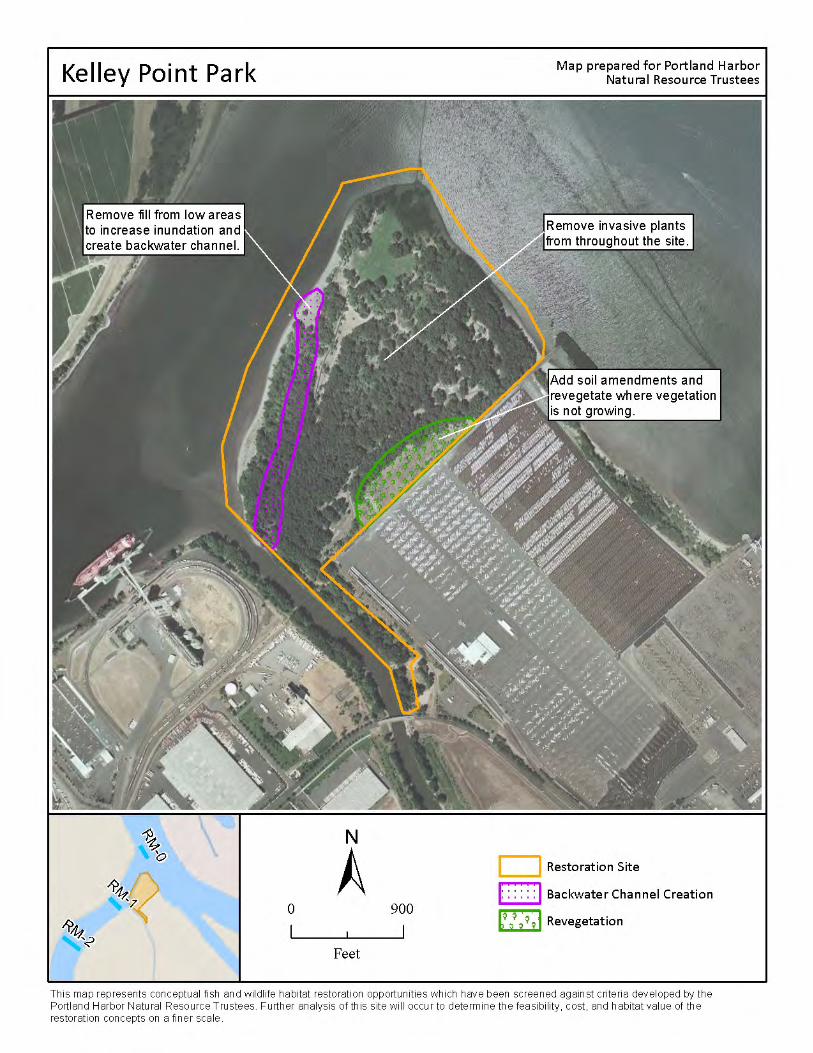
Portland Harbor Natural Resource Restoration Portfolio: April 2012 65
KELL O G G DA M RE M OVA L
Landowner: City of Milwaukie, Oregon Department of Transportation, Oregon Department of State
Lands, private property owners
Site description: This site is located on the east side of the Willamette River at river mile 18, upstream of
the Portland Harbor Study Area and immediately south of downtown Milwaukie. Kellogg Dam was
originally constructed to power a grist mill in 1858 and has been reinforced several times since then. The
dam is a significant barrier to fish passage on Kellogg Creek. Behind the dam sits Kellogg Lake, a 14-acre
warm water reservoir with average depths ranging from 1 to 3 feet.
Proposed restoration: Restoration at this site would include the removal of a dam on Kellogg Creek, a
major tributary of the Willamette River, and draining Kellogg Lake. This project would restore tributary,
wetland and native riparian habitat, including creation of an approximately .75-mile meandering stream
channel within the former lake bed, control of exotic, invasive plant communities, planting of native
vegetation, and placement of large woody debris structures.
Benefits: Dam removal would open up fish access to the lower 5-mile extent of Kellogg Creek and
provide partial passage to the upper reaches of the Kellogg-Mt. Scott watershed (a total of 9 miles of
passage), increasing the availability of shallow water and off-channel habitat. Drainage of Kellogg Lake
would eliminate a known detriment to salmonid populations by reducing water temperatures and
predation concerns. Management of contaminated sediments in the lake could decrease risks to fish
and wildlife and improve overall water quality. Habitat enhancements within the lake bed would provide
cold-water rearing and refuge areas for juvenile coho and spring Chinook and would create new
floodplain capacity. The cold water springs surrounding the site may also contribute unique habitat for
terrestrial and aquatic species. Removal of invasive plant species and revegetation with native species
would provide diverse habitats for native macro-invertebrate, amphibian and wildlife communities. The
site is adjacent to Milwaukie’s developing, transit-oriented South Downtown and could provide public
education and recreation benefits in addition to habitat benefits.
Feasibility: The site is in public ownership and the landowner is supportive of the restoration work. In
2002, the U.S. Army Corps of Engineers (Corps) detected contaminants in lakebed sediments above the
guidelines adopted for use in the Dredge Material Evaluation Framework and DEQ’s Level II screening
values at multiple sample points. Sediment management would be necessary as part of the restoration
effort. Highway 99E sits atop the dam and transportation upgrades may be necessary if the dam is
removed. In addition, a sanitary sewer line, which sits on the lakebed one-half mile above the dam,
would need to be relocated. TriMet’s Light Rail Transit crossing will be built over the lake just upstream
of Hwy 99E, adjacent to an active Union Pacific Rail Road trestle, adding infrastructure considerations to
the project.

66 Portland Harbor Natural Resource Restoration Portfolio: April 2012
Other constraints/considerations: The Corps has re-initiated a feasibility study, which will likely be
completed in 2011. Project design could commence in 2011 with the possibility for in-water
construction in 2013. A number of private landowners currently border the lakebed; the City of
Milwaukie is actively working with these landowners to address potential concerns about the project
and continue to build community support.
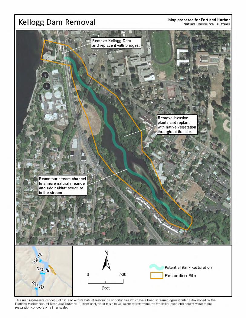
68 Portland Harbor Natural Resource Restoration Portfolio: April 2012
MA RY S. YO UN G ST ATE PA RK
Landowner: Oregon Parks and Recreation Department (managed by City of West Linn Parks and
Recreation), Oregon Department of State Lands
Site Description: Mary S. Young State Park (MSY Park) is a 128-acre park located along the Willamette
River in West Linn. There are nearly 8 miles of trails in the park, along with athletic fields, parking lots
and a pet exercise area. Over 90 acres of MSY Park are forested, primarily with Douglas fir and Western
hemlock and a riparian zone of black cottonwood, mixed willow species, and red twig dogwood.
Invasive English ivy is found throughout much of the upland areas, although the city and local volunteer
groups are working to remove it. Invasive species such as Armenian blackberry and reed canary grass
are found in the riparian zone.
Several small creeks, including Mary S. Young Creek and Turkey Creek, flow through MSY Park to their
confluences with the Willamette River. The Oregon Department of Fish and Wildlife has found juvenile
Chinook and coho salmon in Mary S. Young Creek. The shoreline at MSY Park retains its natural contour,
and alternates between sandy beaches and basaltic outcrops. These outcrops form a small lagoon at
the downriver end of the shoreline and protect the beaches at the upriver end of the shoreline.
Proposed Restoration: Restoration at this site could include enhancing shoreline complexity along the
beach and in the lagoon area and removal of non-native vegetation and native plantings within the
riparian areas. In addition, there is an opportunity to reconnect a side channel of the river and regrade
the floodplain upstream of the lagoon. Finally, replacing the culvert along Mary S. Young Creek and
restoration of the creek to its original channel is also a possibility.
Benefits: Reconnecting side channels and floodplains to the main channel are among the most effective
restoration strategies to benefit juvenile Chinook salmon as they provide off-channel refugia during high
river flows. Replacing culverts, restoring the creek’s original channel form, and enhancing habitat
complexity along the Willamette shoreline and in the lagoon would provide additional refugia and
habitat for migrating salmonids (particularly juveniles) and other native fish and wildlife species.
Restoring the native plant community along the riparian corridor would provide valuable feeding,
dispersal, and breeding habitat for native terrestrial wildlife species as well as migratory bird species
near the confluence of the Willamette and Clackamas Rivers. In addition, a healthy native riparian
vegetation community stabilizes stream banks, reduces and/or captures sediment flows, cycles nutrients
and provides a source of large wood for adjacent and downstream areas.
Feasibility: Project site is publicly owned and already protected as a natural area. Site was previously a
private estate; no known contamination issues are present. Replacement of a pipeline that runs
through part of the site is in the planning stages. Timing of restoration at the site must take these
activities into consideration and avoid the pipeline during any excavation work.

Portland Harbor Natural Resource Restoration Portfolio: April 2012 69
Other constraints/considerations: Part of the restoration area is currently used as an off-leash area for
dogs. Appropriate restrictions may be necessary to ensure riparian restoration and plantings are not
disturbed by park users including off-leash pets.
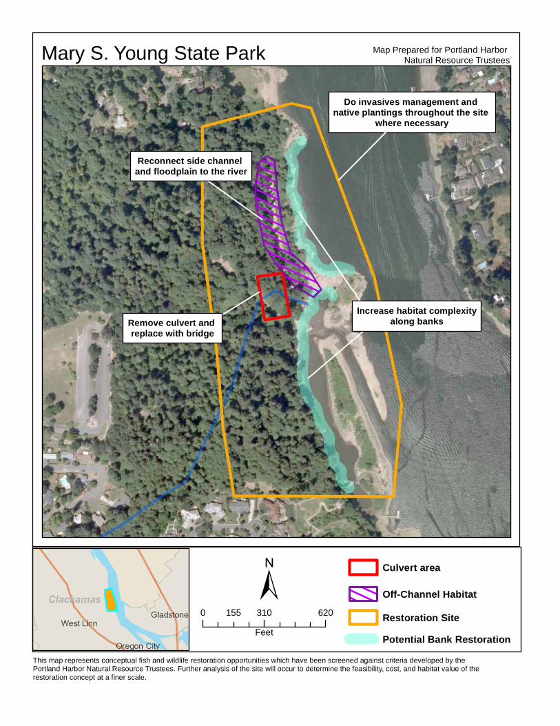
This map represents conceptual fish and wildlife restoration opportunities which have been screened against criteria developed by the Portland Harbor Natural Resource Trustees. Further analysis of the site will occur to determine the feasibility, cost, and habitat value of the restoration concept at a finer scale.
±
Map Prepared for Portland Harbor Natural Resource TrusteesMary S. Young State Park
Remove culvert and replace with bridge
Reconnect side channel and floodplain to the river
Increase habitat complexityalong banks
Do invasives management and native plantings throughout the site
where necessary
0 310 620155Feet
Culvert area
Off-Channel HabitatRestoration SitePotential Bank Restoration
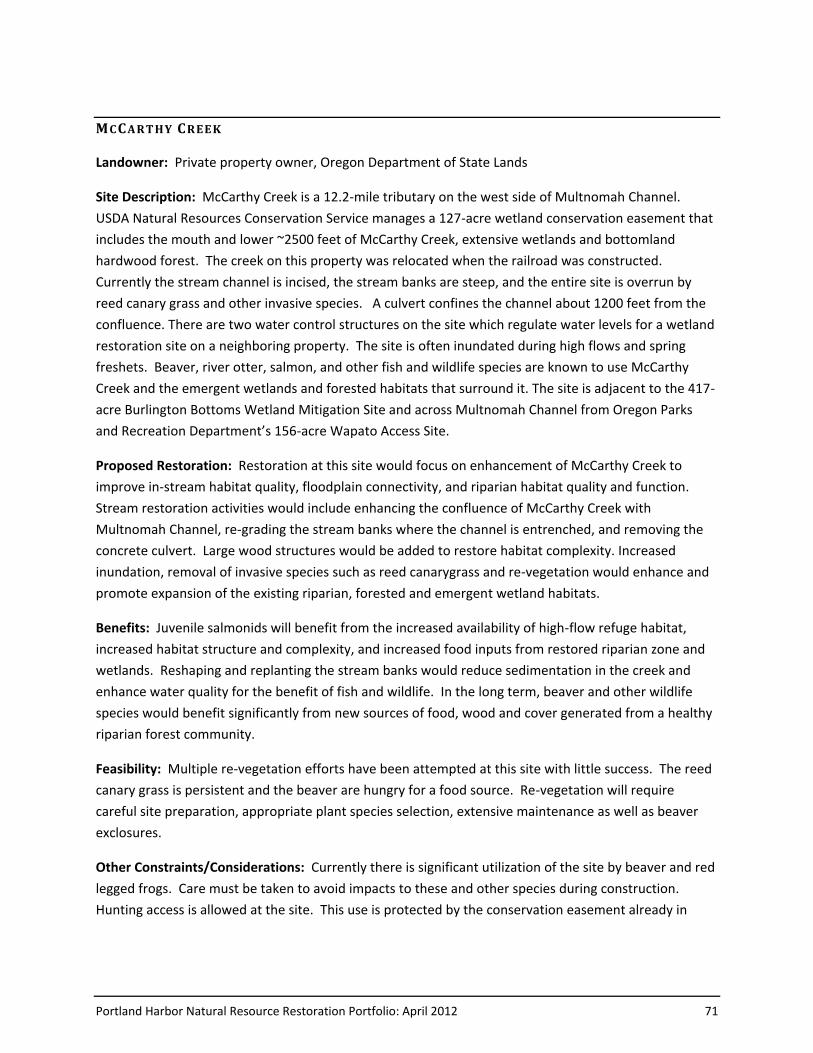
Portland Harbor Natural Resource Restoration Portfolio: April 2012 71
MCCA RT HY CREE K
Landowner: Private property owner, Oregon Department of State Lands
Site Description: McCarthy Creek is a 12.2-mile tributary on the west side of Multnomah Channel.
USDA Natural Resources Conservation Service manages a 127-acre wetland conservation easement that
includes the mouth and lower ~2500 feet of McCarthy Creek, extensive wetlands and bottomland
hardwood forest. The creek on this property was relocated when the railroad was constructed.
Currently the stream channel is incised, the stream banks are steep, and the entire site is overrun by
reed canary grass and other invasive species. A culvert confines the channel about 1200 feet from the
confluence. There are two water control structures on the site which regulate water levels for a wetland
restoration site on a neighboring property. The site is often inundated during high flows and spring
freshets. Beaver, river otter, salmon, and other fish and wildlife species are known to use McCarthy
Creek and the emergent wetlands and forested habitats that surround it. The site is adjacent to the 417-
acre Burlington Bottoms Wetland Mitigation Site and across Multnomah Channel from Oregon Parks
and Recreation Department’s 156-acre Wapato Access Site.
Proposed Restoration: Restoration at this site would focus on enhancement of McCarthy Creek to
improve in-stream habitat quality, floodplain connectivity, and riparian habitat quality and function.
Stream restoration activities would include enhancing the confluence of McCarthy Creek with
Multnomah Channel, re-grading the stream banks where the channel is entrenched, and removing the
concrete culvert. Large wood structures would be added to restore habitat complexity. Increased
inundation, removal of invasive species such as reed canarygrass and re-vegetation would enhance and
promote expansion of the existing riparian, forested and emergent wetland habitats.
Benefits: Juvenile salmonids will benefit from the increased availability of high-flow refuge habitat,
increased habitat structure and complexity, and increased food inputs from restored riparian zone and
wetlands. Reshaping and replanting the stream banks would reduce sedimentation in the creek and
enhance water quality for the benefit of fish and wildlife. In the long term, beaver and other wildlife
species would benefit significantly from new sources of food, wood and cover generated from a healthy
riparian forest community.
Feasibility: Multiple re-vegetation efforts have been attempted at this site with little success. The reed
canary grass is persistent and the beaver are hungry for a food source. Re-vegetation will require
careful site preparation, appropriate plant species selection, extensive maintenance as well as beaver
exclosures.
Other Constraints/Considerations: Currently there is significant utilization of the site by beaver and red
legged frogs. Care must be taken to avoid impacts to these and other species during construction.
Hunting access is allowed at the site. This use is protected by the conservation easement already in

72 Portland Harbor Natural Resource Restoration Portfolio: April 2012
place on the site. There may be other aspects of the existing easement that need to be taken into
consideration during restoration planning and implementation.
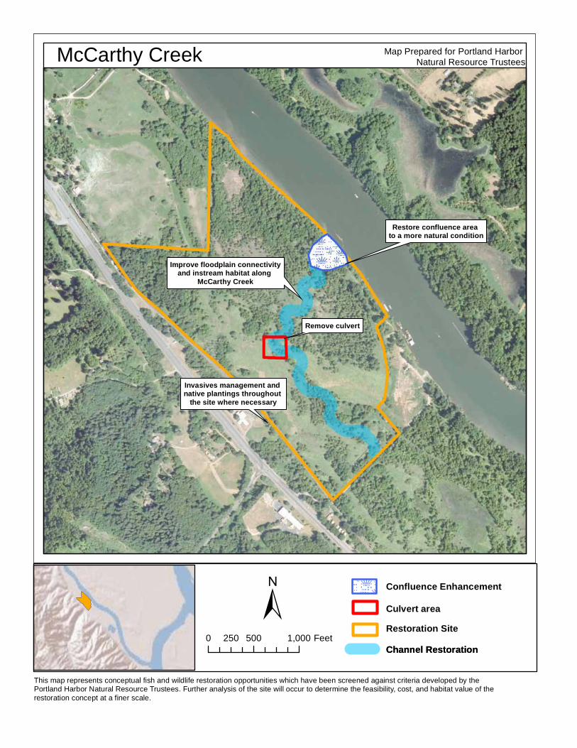
Map Prepared for Portland Harbor Natural Resource TrusteesMcCarthy Creek
Improve floodplain connectivityand instream habitat along
McCarthy Creek
Remove culvert
Restore confluence area to a more natural condition
Invasives management and native plantings throughout
the site where necessary
Channel Restoration
This map represents conceptual fish and wildlife restoration opportunities which have been screened against criteria developed by the Portland Harbor Natural Resource Trustees. Further analysis of the site will occur to determine the feasibility, cost, and habitat value of the restoration concept at a finer scale.
Confluence EnhancementCulvert areaRestoration SiteChannel Restoration
±0 500 1,000250 Feet
74 Portland Harbor Natural Resource Restoration Portfolio: April 2012
OA KS AM USE ME NT PA RK/OA KS CRO S S IN G
Landowners: Oaks Park Association, City of Portland, Metro, Oregon Department of State Lands
Site description: Oaks Amusement Park is located at river mile 16 on the east bank of the Willamette
River. The park area adjacent to the river consists of a low riparian zone lined with native and invasive
vegetation that averages approximately 40 feet in width. Upslope, the bank is lined with a fence and
walking path that serves as the boundary of the amusement park. The low floodplain willow thicket
wetland is submerged at high flows and may serve as high water refuge habitat. Oaks Crossing is a
riverfront park located at river mile 16.25 of the Willamette River with significant beach, bottomland
forest and wetland habitat within the floodplain. These sites are located in close proximity to the Oaks
Bottom wildlife area.
Proposed restoration: Restoration at Oaks Amusement Park and Oaks Crossing could include enhancing
the area’s existing native plant community by removing invasive plants, and increasing the amount of
wood on the banks and in shallow water channel areas. At Oaks Crossing, there is the potential to
investigate the feasibility of creating off-channel habitat. At Oaks Amusement Park, there may be an
opportunity to reconfigure some banks to increase the amount of floodplain and flood storage, and to
create shallow and off-channel habitat.
Benefits: Improvements in nearshore aquatic habitat, riparian areas and floodplain connectivity would
improve rearing and refuge habitat for fish species and enhance important feeding, breeding and
nesting habitat for native wildlife. Off-channel, shallow, slow moving waters provide refuge and
productive foraging areas for lamprey and juvenile salmon. Improving riparian vegetation would help
stabilize stream banks, capture sediment in stormwater runoff, support natural hydrologic flow
processes and nutrient cycling, and provide a source of woody materials to the river.
Feasibility: Existing infrastructure at Oaks Crossing includes power lines and towers, boat docks, piers,
parking lots and roads. This infrastructure may limit opportunities for significant bank improvements.
Other constraints/considerations: Oaks Amusement Park is privately owned and landowner willingness
is unknown at this time. Recreational use associated with the park may affect or limit the ecological
benefits provided by restoration at the site.
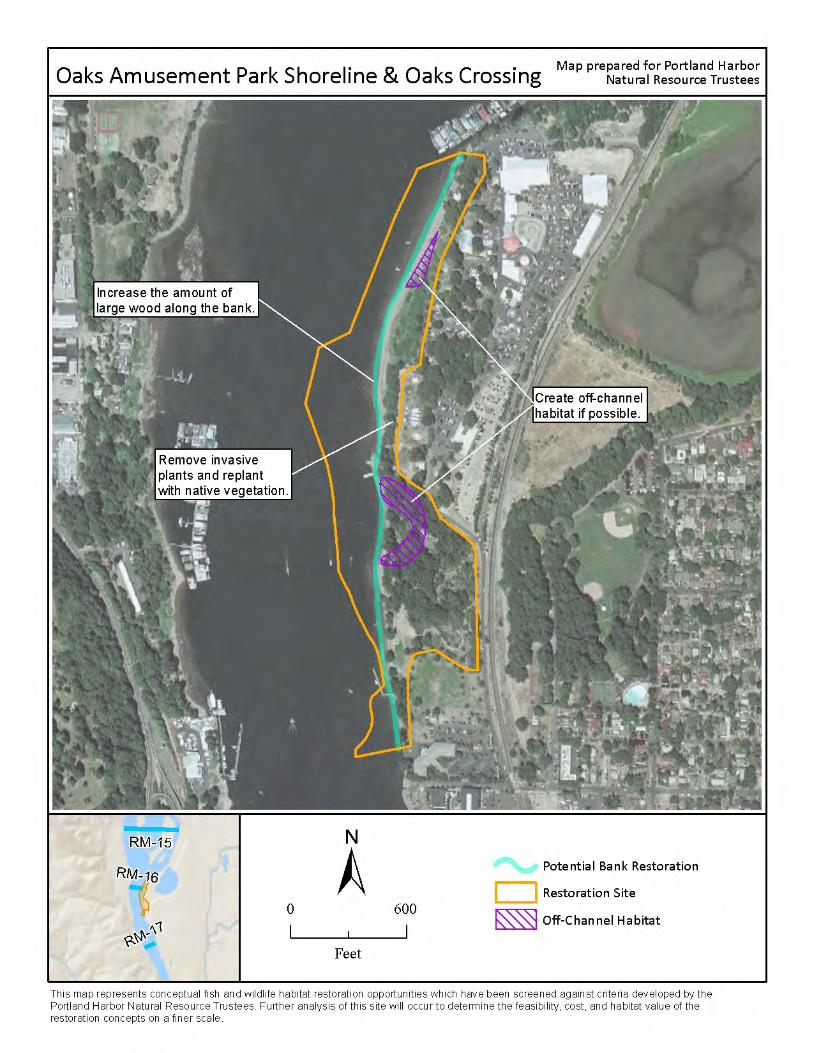
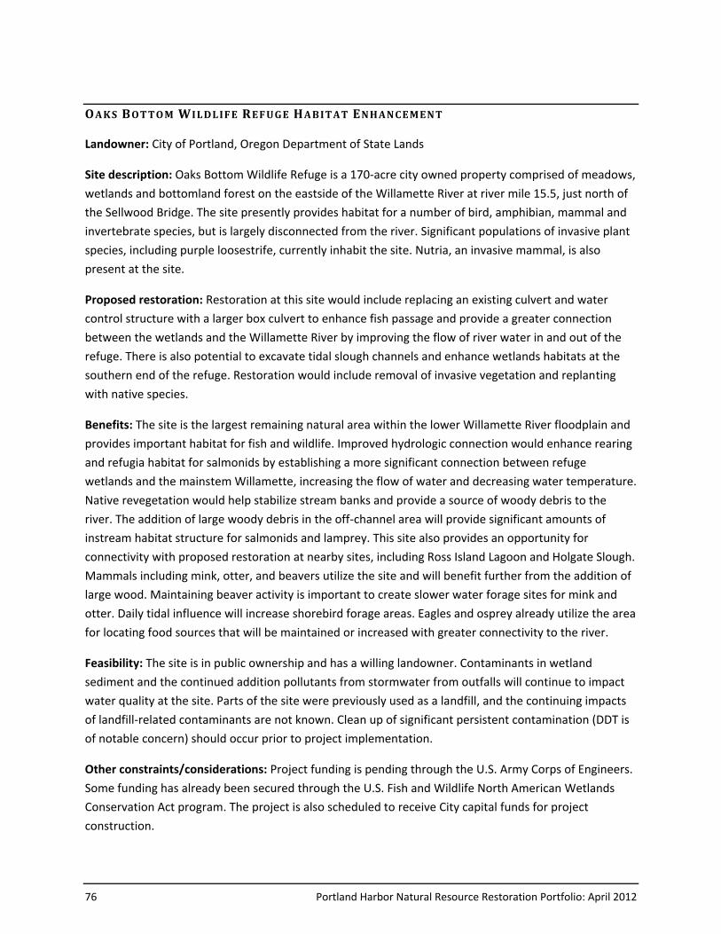
76 Portland Harbor Natural Resource Restoration Portfolio: April 2012
OA KS BOT TO M W ILDL IF E REF UGE HA B IT AT EN HAN CE MEN T
Landowner: City of Portland, Oregon Department of State Lands
Site description: Oaks Bottom Wildlife Refuge is a 170-acre city owned property comprised of meadows,
wetlands and bottomland forest on the eastside of the Willamette River at river mile 15.5, just north of
the Sellwood Bridge. The site presently provides habitat for a number of bird, amphibian, mammal and
invertebrate species, but is largely disconnected from the river. Significant populations of invasive plant
species, including purple loosestrife, currently inhabit the site. Nutria, an invasive mammal, is also
present at the site.
Proposed restoration: Restoration at this site would include replacing an existing culvert and water
control structure with a larger box culvert to enhance fish passage and provide a greater connection
between the wetlands and the Willamette River by improving the flow of river water in and out of the
refuge. There is also potential to excavate tidal slough channels and enhance wetlands habitats at the
southern end of the refuge. Restoration would include removal of invasive vegetation and replanting
with native species.
Benefits: The site is the largest remaining natural area within the lower Willamette River floodplain and
provides important habitat for fish and wildlife. Improved hydrologic connection would enhance rearing
and refugia habitat for salmonids by establishing a more significant connection between refuge
wetlands and the mainstem Willamette, increasing the flow of water and decreasing water temperature.
Native revegetation would help stabilize stream banks and provide a source of woody debris to the
river. The addition of large woody debris in the off-channel area will provide significant amounts of
instream habitat structure for salmonids and lamprey. This site also provides an opportunity for
connectivity with proposed restoration at nearby sites, including Ross Island Lagoon and Holgate Slough.
Mammals including mink, otter, and beavers utilize the site and will benefit further from the addition of
large wood. Maintaining beaver activity is important to create slower water forage sites for mink and
otter. Daily tidal influence will increase shorebird forage areas. Eagles and osprey already utilize the area
for locating food sources that will be maintained or increased with greater connectivity to the river.
Feasibility: The site is in public ownership and has a willing landowner. Contaminants in wetland
sediment and the continued addition pollutants from stormwater from outfalls will continue to impact
water quality at the site. Parts of the site were previously used as a landfill, and the continuing impacts
of landfill-related contaminants are not known. Clean up of significant persistent contamination (DDT is
of notable concern) should occur prior to project implementation.
Other constraints/considerations: Project funding is pending through the U.S. Army Corps of Engineers.
Some funding has already been secured through the U.S. Fish and Wildlife North American Wetlands
Conservation Act program. The project is also scheduled to receive City capital funds for project
construction.
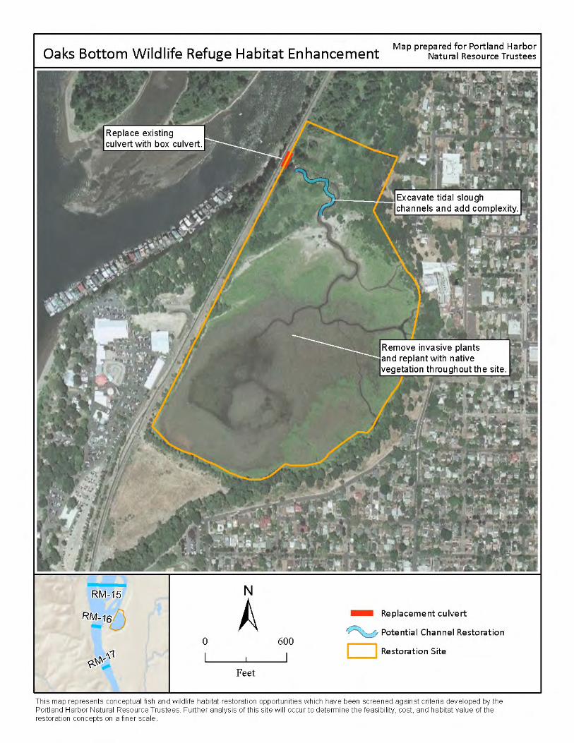
78 Portland Harbor Natural Resource Restoration Portfolio: April 2012
ORE G ON YAC HT CL UB W IL DL IF E HA B IT AT
Landowners: Oregon Yacht Club, City of Portland
Site description: The Oregon Yacht Club is located at river mile 15.75 on the east bank of the Willamette
River, abutting Oaks Bottom Wildlife Refuge. Although some filling and bank alterations have occurred
in the past, this site is primarily vegetated floodplain with no apparent structures. A houseboat
community is located just offshore. The riparian zone at this site ranges from 100-200 feet in width.
Mature trees with native/non-native understory comprise most of the area, with some disturbed and
bare areas across the site. The site’s close proximity to significant natural areas such as Oaks Bottom
Wildlife Refuge and Ross Island increases the value of habitat protection and improvement on this
property for wildlife and aquatic species.
Proposed restoration: Restoration at this site could include removing invasive plants and increasing the
amount and quality of vegetation in floodplain and riparian areas. Filled and disturbed areas could be
restored. Snags and downed large wood could be increased along the banks and throughout the
floodplain.
Benefits: This site could be protected and maintained as a natural area. Improvements in the banks and
floodplains would enhance important feeding, breeding and nesting habitat and movement corridors for
native wildlife. Improving riparian vegetation would increase the quality and quantity of wildlife food
and cover, help stabilize stream banks, capture sediment in stormwater runoff, support natural
hydrologic flow processes and nutrient cycling, and provide a source of wood material to the river and
to floodplain and riparian habitats. Mature patches of trees exist on the site that can provide perching
and nesting opportunities for bald eagle and osprey.
Feasibility: Implementation of this project will require the permission and cooperation of the Oregon
Yacht Club (landowner has indicated willingness to allow some level of restoration). The amount of
aquatic species-related restoration may be limited by the need to protect existing terrestrial habitat and
to ensure an attractive nuisance is not created if sediments along the shoreline are contaminated. The
proximity of houseboats may preclude the addition of large wood, or require that the wood be stabilized
so that it does not threaten the houseboats.
Other constraints/considerations: The presence of houseboats may constrain the extent to which
potentially mobile large wood could be incorporated into project design. Current human uses at the site
should be further evaluated and addressed in a restoration plan for the area.
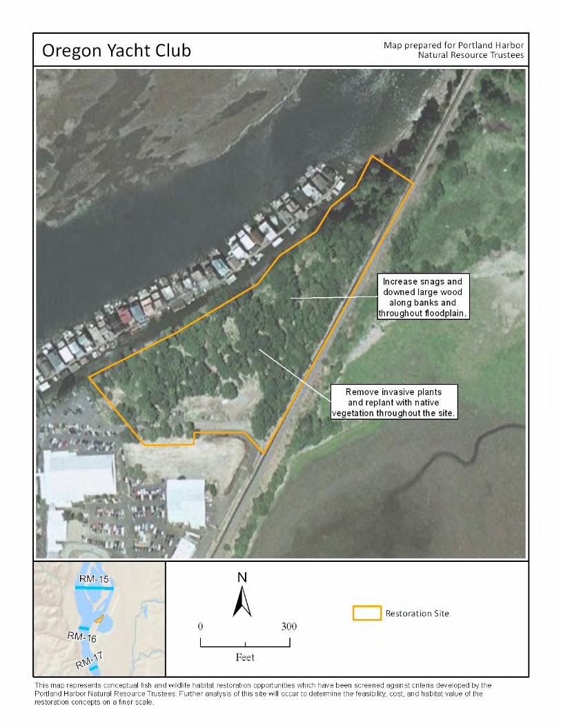
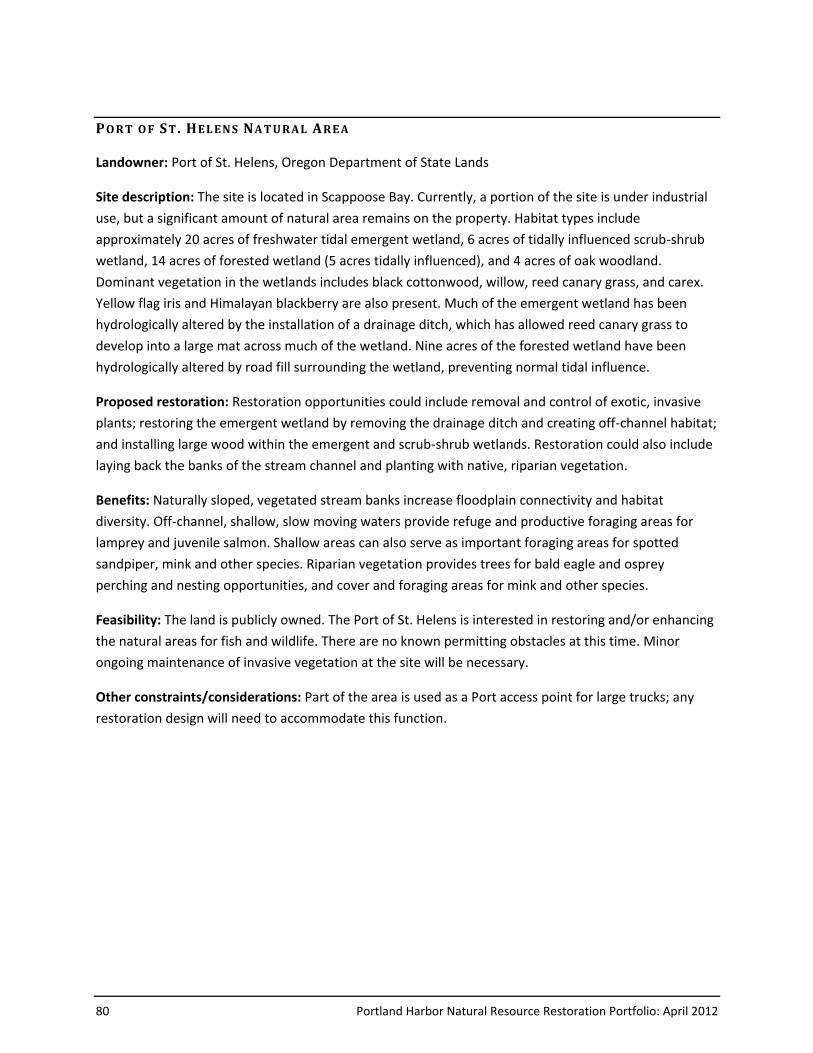
80 Portland Harbor Natural Resource Restoration Portfolio: April 2012
PO RT O F ST . HEL EN S NA T URA L ARE A
Landowner: Port of St. Helens, Oregon Department of State Lands
Site description: The site is located in Scappoose Bay. Currently, a portion of the site is under industrial
use, but a significant amount of natural area remains on the property. Habitat types include
approximately 20 acres of freshwater tidal emergent wetland, 6 acres of tidally influenced scrub-shrub
wetland, 14 acres of forested wetland (5 acres tidally influenced), and 4 acres of oak woodland.
Dominant vegetation in the wetlands includes black cottonwood, willow, reed canary grass, and carex.
Yellow flag iris and Himalayan blackberry are also present. Much of the emergent wetland has been
hydrologically altered by the installation of a drainage ditch, which has allowed reed canary grass to
develop into a large mat across much of the wetland. Nine acres of the forested wetland have been
hydrologically altered by road fill surrounding the wetland, preventing normal tidal influence.
Proposed restoration: Restoration opportunities could include removal and control of exotic, invasive
plants; restoring the emergent wetland by removing the drainage ditch and creating off-channel habitat;
and installing large wood within the emergent and scrub-shrub wetlands. Restoration could also include
laying back the banks of the stream channel and planting with native, riparian vegetation.
Benefits: Naturally sloped, vegetated stream banks increase floodplain connectivity and habitat
diversity. Off-channel, shallow, slow moving waters provide refuge and productive foraging areas for
lamprey and juvenile salmon. Shallow areas can also serve as important foraging areas for spotted
sandpiper, mink and other species. Riparian vegetation provides trees for bald eagle and osprey
perching and nesting opportunities, and cover and foraging areas for mink and other species.
Feasibility: The land is publicly owned. The Port of St. Helens is interested in restoring and/or enhancing
the natural areas for fish and wildlife. There are no known permitting obstacles at this time. Minor
ongoing maintenance of invasive vegetation at the site will be necessary.
Other constraints/considerations: Part of the area is used as a Port access point for large trucks; any
restoration design will need to accommodate this function.
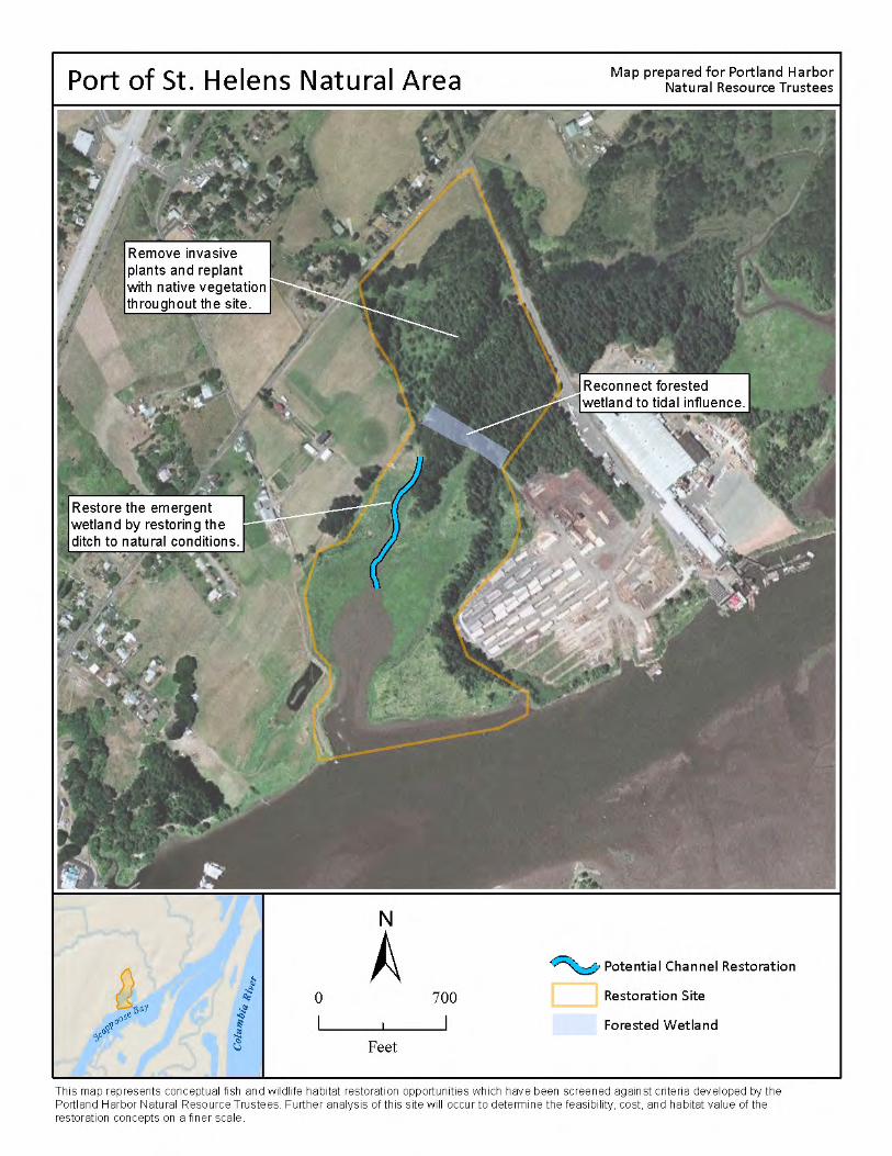
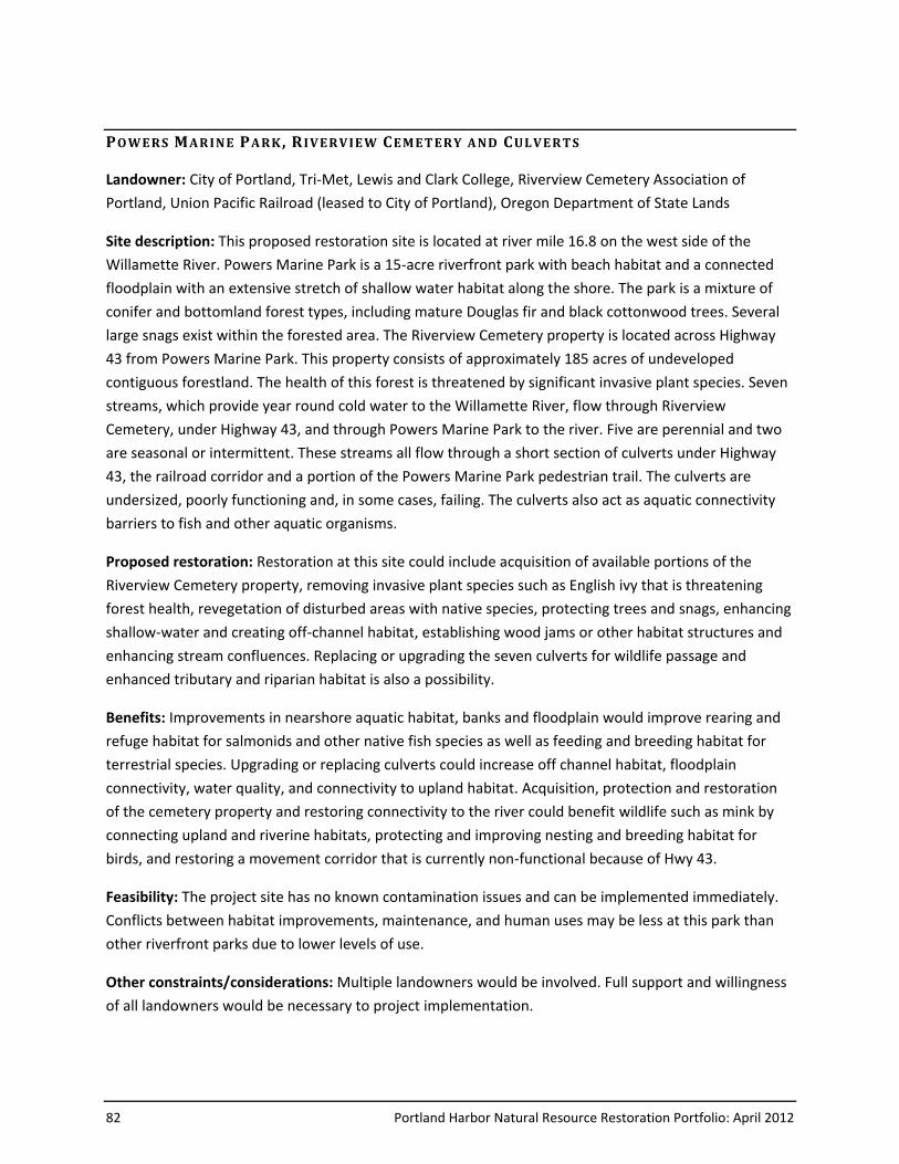
82 Portland Harbor Natural Resource Restoration Portfolio: April 2012
PO W E RS MA RINE PA RK , R IV E RV IE W CE MET ERY A ND CULV E RTS
Landowner: City of Portland, Tri-Met, Lewis and Clark College, Riverview Cemetery Association of
Portland, Union Pacific Railroad (leased to City of Portland), Oregon Department of State Lands
Site description: This proposed restoration site is located at river mile 16.8 on the west side of the
Willamette River. Powers Marine Park is a 15-acre riverfront park with beach habitat and a connected
floodplain with an extensive stretch of shallow water habitat along the shore. The park is a mixture of
conifer and bottomland forest types, including mature Douglas fir and black cottonwood trees. Several
large snags exist within the forested area. The Riverview Cemetery property is located across Highway
43 from Powers Marine Park. This property consists of approximately 185 acres of undeveloped
contiguous forestland. The health of this forest is threatened by significant invasive plant species. Seven
streams, which provide year round cold water to the Willamette River, flow through Riverview
Cemetery, under Highway 43, and through Powers Marine Park to the river. Five are perennial and two
are seasonal or intermittent. These streams all flow through a short section of culverts under Highway
43, the railroad corridor and a portion of the Powers Marine Park pedestrian trail. The culverts are
undersized, poorly functioning and, in some cases, failing. The culverts also act as aquatic connectivity
barriers to fish and other aquatic organisms.
Proposed restoration: Restoration at this site could include acquisition of available portions of the
Riverview Cemetery property, removing invasive plant species such as English ivy that is threatening
forest health, revegetation of disturbed areas with native species, protecting trees and snags, enhancing
shallow-water and creating off-channel habitat, establishing wood jams or other habitat structures and
enhancing stream confluences. Replacing or upgrading the seven culverts for wildlife passage and
enhanced tributary and riparian habitat is also a possibility.
Benefits: Improvements in nearshore aquatic habitat, banks and floodplain would improve rearing and
refuge habitat for salmonids and other native fish species as well as feeding and breeding habitat for
terrestrial species. Upgrading or replacing culverts could increase off channel habitat, floodplain
connectivity, water quality, and connectivity to upland habitat. Acquisition, protection and restoration
of the cemetery property and restoring connectivity to the river could benefit wildlife such as mink by
connecting upland and riverine habitats, protecting and improving nesting and breeding habitat for
birds, and restoring a movement corridor that is currently non-functional because of Hwy 43.
Feasibility: The project site has no known contamination issues and can be implemented immediately.
Conflicts between habitat improvements, maintenance, and human uses may be less at this park than
other riverfront parks due to lower levels of use.
Other constraints/considerations: Multiple landowners would be involved. Full support and willingness
of all landowners would be necessary to project implementation.
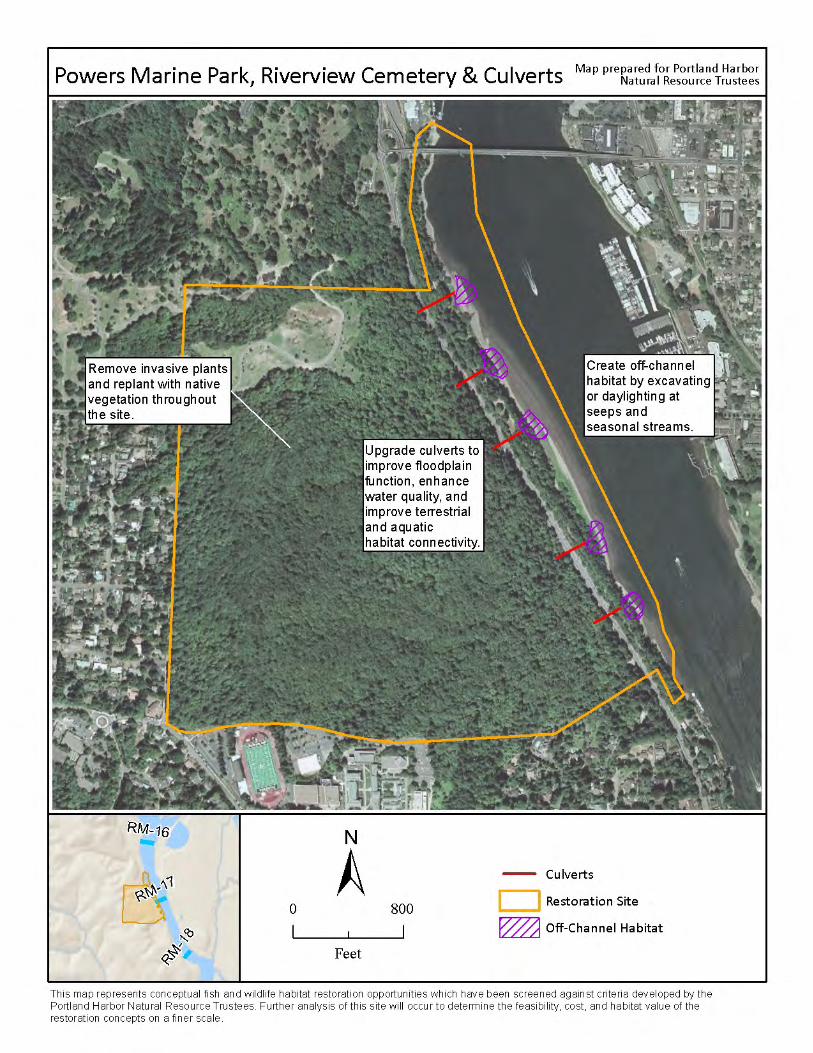
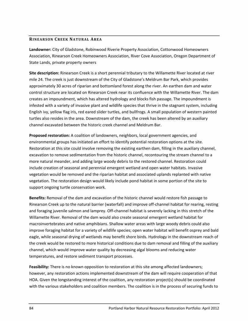
84 Portland Harbor Natural Resource Restoration Portfolio: April 2012
R IN EA RS ON CREE K NAT URAL AREA
Landowner: City of Gladstone, Robinwood Riverie Property Association, Cottonwood Homeowners
Association, Rinearson Creek Homeowners Association, River Cove Association, Oregon Department of
State Lands, private property owners
Site description: Rinearson Creek is a short perennial tributary to the Willamette River located at river
mile 24. The creek is just downstream of the City of Gladstone’s Meldrum Bar Park, which provides
approximately 30 acres of riparian and bottomland forest along the river. An earthen dam and water
control structure are located on Rinearson Creek near its confluence with the Willamette River. The dam
creates an impoundment, which has altered hydrology and blocks fish passage. The impoundment is
infested with a variety of invasive plant and wildlife species that thrive in the stagnant system, including
English ivy, yellow flag iris, red eared slider turtles, and bullfrogs. A small population of western painted
turtles also resides in the area. Downstream of the dam, the creek has been altered by an auxiliary
channel excavated between the historic creek channel and Meldrum Bar.
Proposed restoration: A coalition of landowners, neighbors, local government agencies, and
environmental groups has initiated an effort to identify potential restoration options at the site.
Restoration at this site could involve removing the existing earthen dam, filling in the auxiliary channel,
excavation to remove sedimentation from the historic channel, recontouring the stream channel to a
more natural meander, and adding large woody debris to the restored channel. Restoration could
include creation of seasonal and perennial emergent wetland and open water habitats. Invasive
vegetation would be removed and the riparian habitat and associated uplands replanted with native
vegetation. The restoration design would likely include pond habitat in some portion of the site to
support ongoing turtle conservation work.
Benefits: Removal of the dam and excavation of the historic channel would restore fish passage to
Rinearson Creek up to the natural barrier (waterfall) and improve off-channel habitat for rearing, resting
and foraging juvenile salmon and lamprey. Off-channel habitat is severely lacking in this stretch of the
Willamette River. Removal of the dam would also create seasonal emergent wetland habitat for
macroinvertebrates and native amphibians. Shallow water areas with large woody debris could also
improve foraging habitat for a variety of wildlife species; open water habitat will benefit osprey and bald
eagle, while seasonal drying of wetlands may benefit shore birds. Hydrology in the downstream reach of
the creek would be restored to more historical conditions due to dam removal and filling of the auxiliary
channel, which would improve water quality by decreasing algal blooms and reducing water
temperatures, and restore sediment transport processes.
Feasibility: There is no known opposition to restoration at this site among affected landowners;
however, any restoration actions implemented downstream of the dam will require cooperation of that
HOA. Given the longstanding interest of the coalition, any restoration project(s) should be coordinated
with the various stakeholders and coalition members. The coalition is in the process of securing funds to
Portland Harbor Natural Resource Restoration Portfolio: April 2012 85
conduct a feasibility study of restoration options at the site. The study is expected to be complete in
2011.
Other constraints/considerations: The dam was originally built as mitigation for filling of wetlands at
the headwaters of Rinearson Creek in 1997 pursuant to a Clean Water Act Section 404 permit. It has
since been determined that the original goals of the permit were never achieved as the dam has not
been managed as originally intended. Further discussion is needed with the U.S. Army Corps of
Engineers in regards to the permit. Potential sediment contamination issues have not been explored;
these may be addressed in the feasibility study described above.
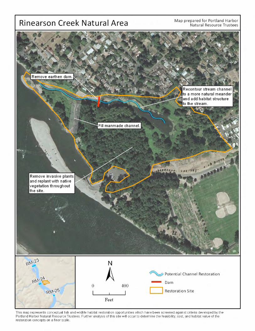
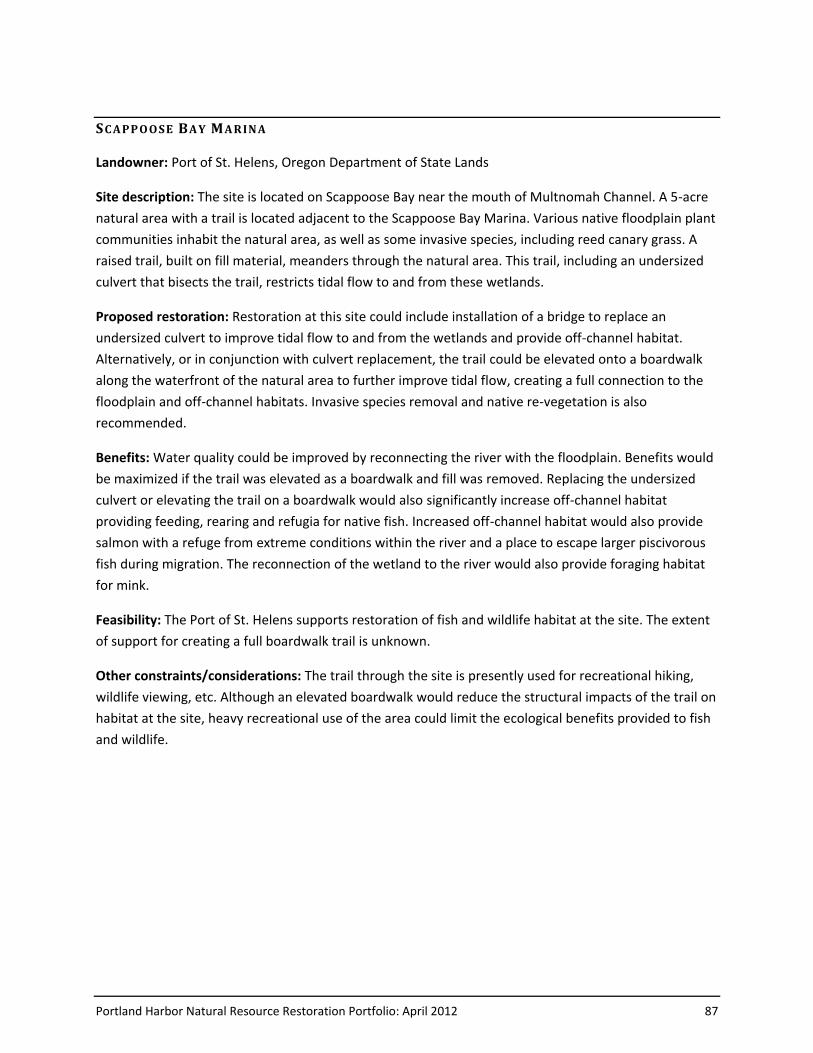
Portland Harbor Natural Resource Restoration Portfolio: April 2012 87
SC A PP O O SE BA Y MA RIN A
Landowner: Port of St. Helens, Oregon Department of State Lands
Site description: The site is located on Scappoose Bay near the mouth of Multnomah Channel. A 5-acre
natural area with a trail is located adjacent to the Scappoose Bay Marina. Various native floodplain plant
communities inhabit the natural area, as well as some invasive species, including reed canary grass. A
raised trail, built on fill material, meanders through the natural area. This trail, including an undersized
culvert that bisects the trail, restricts tidal flow to and from these wetlands.
Proposed restoration: Restoration at this site could include installation of a bridge to replace an
undersized culvert to improve tidal flow to and from the wetlands and provide off-channel habitat.
Alternatively, or in conjunction with culvert replacement, the trail could be elevated onto a boardwalk
along the waterfront of the natural area to further improve tidal flow, creating a full connection to the
floodplain and off-channel habitats. Invasive species removal and native re-vegetation is also
recommended.
Benefits: Water quality could be improved by reconnecting the river with the floodplain. Benefits would
be maximized if the trail was elevated as a boardwalk and fill was removed. Replacing the undersized
culvert or elevating the trail on a boardwalk would also significantly increase off-channel habitat
providing feeding, rearing and refugia for native fish. Increased off-channel habitat would also provide
salmon with a refuge from extreme conditions within the river and a place to escape larger piscivorous
fish during migration. The reconnection of the wetland to the river would also provide foraging habitat
for mink.
Feasibility: The Port of St. Helens supports restoration of fish and wildlife habitat at the site. The extent
of support for creating a full boardwalk trail is unknown.
Other constraints/considerations: The trail through the site is presently used for recreational hiking,
wildlife viewing, etc. Although an elevated boardwalk would reduce the structural impacts of the trail on
habitat at the site, heavy recreational use of the area could limit the ecological benefits provided to fish
and wildlife.
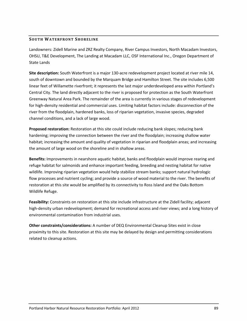
Portland Harbor Natural Resource Restoration Portfolio: April 2012 89
SO UT H WAT E RF RO NT SHO REL INE
Landowners: Zidell Marine and ZRZ Realty Company, River Campus Investors, North Macadam Investors,
OHSU, T&E Development, The Landing at Macadam LLC, OSF International Inc., Oregon Department of
State Lands
Site description: South Waterfront is a major 130-acre redevelopment project located at river mile 14,
south of downtown and bounded by the Marquam Bridge and Hamilton Street. The site includes 6,500
linear feet of Willamette riverfront; it represents the last major underdeveloped area within Portland’s
Central City. The land directly adjacent to the river is proposed for protection as the South Waterfront
Greenway Natural Area Park. The remainder of the area is currently in various stages of redevelopment
for high-density residential and commercial uses. Limiting habitat factors include: disconnection of the
river from the floodplain, hardened banks, loss of riparian vegetation, invasive species, degraded
channel conditions, and a lack of large wood.
Proposed restoration: Restoration at this site could include reducing bank slopes; reducing bank
hardening; improving the connection between the river and the floodplain; increasing shallow water
habitat; increasing the amount and quality of vegetation in riparian and floodplain areas; and increasing
the amount of large wood on the shoreline and in shallow areas.
Benefits: Improvements in nearshore aquatic habitat, banks and floodplain would improve rearing and
refuge habitat for salmonids and enhance important feeding, breeding and nesting habitat for native
wildlife. Improving riparian vegetation would help stabilize stream banks; support natural hydrologic
flow processes and nutrient cycling; and provide a source of wood material to the river. The benefits of
restoration at this site would be amplified by its connectivity to Ross Island and the Oaks Bottom
Wildlife Refuge.
Feasibility: Constraints on restoration at this site include infrastructure at the Zidell facility; adjacent
high-density urban redevelopment; demand for recreational access and river views; and a long history of
environmental contamination from industrial uses.
Other constraints/considerations: A number of DEQ Environmental Cleanup Sites exist in close
proximity to this site. Restoration at this site may be delayed by design and permitting considerations
related to cleanup actions.
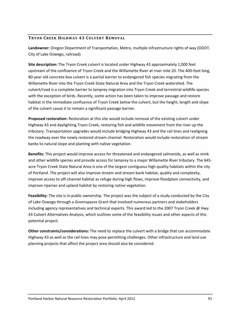
Portland Harbor Natural Resource Restoration Portfolio: April 2012 91
TRY O N CREE K H IG HW AY 43 CUL VERT RE M O VAL
Landowner: Oregon Department of Transportation, Metro, multiple infrastructure rights of way (ODOT,
City of Lake Oswego, railroad)
Site description: The Tryon Creek culvert is located under Highway 43 approximately 1,000 feet
upstream of the confluence of Tryon Creek and the Willamette River at river mile 20. The 400-foot long,
80-year old concrete box culvert is a partial barrier to endangered fish species migrating from the
Willamette River into the Tryon Creek State Natural Area and the Tryon Creek watershed. The
culvert/road is a complete barrier to lamprey migration into Tryon Creek and terrestrial wildlife species
with the exception of birds. Recently, some action has been taken to improve passage and restore
habitat in the immediate confluence of Tryon Creek below the culvert, but the height, length and slope
of the culvert cause it to remain a significant passage barrier.
Proposed restoration: Restoration at this site would include removal of the existing culvert under
Highway 43 and daylighting Tryon Creek, restoring fish and wildlife movement from the river up the
tributary. Transportation upgrades would include bridging Highway 43 and the rail lines and realigning
the roadway over the newly restored stream channel. Restoration would include restoration of stream
banks to natural slope and planting with native vegetation.
Benefits: This project would improve access for threatened and endangered salmonids, as well as mink
and other wildlife species and provide access for lamprey to a major Willamette River tributary. The 645-
acre Tryon Creek State Natural Area is one of the largest contiguous high quality habitats within the city
of Portland. The project will also improve stream and stream bank habitat, quality and complexity,
improve access to off-channel habitat as refuge during high flows, improve floodplain connectivity, and
improve riparian and upland habitat by restoring native vegetation.
Feasibility: The site is in public ownership. The project was the subject of a study conducted by the City
of Lake Oswego through a Greenspaces Grant that involved numerous partners and stakeholders
including agency representatives and technical experts. This award led to the 2007 Tryon Creek @ Hwy
43 Culvert Alternatives Analysis, which outlines some of the feasibility issues and other aspects of this
potential project.
Other constraints/considerations: The need to replace the culvert with a bridge that can accommodate
Highway 43 as well as the rail lines may pose permitting challenges. Other infrastructure and land use
planning projects that affect the project area should also be considered.
Portland Harbor Natural Resource Restoration Portfolio: April 2012 93
WA P AT O AC C ES S S ITE
Landowner: Oregon Parks and Recreation Department, Oregon Department of State Lands
Site Description: Wapato Access is an approximately 156-acre natural area located on Sauvie Island
along Multnomah Channel. The site is outside of the Army Corps constructed levee system. The banks
of Multnomah Channel are naturally high at this site, likely due to natural deposition, forming a natural
levee that inhibits fish and all but the highest flood waters from accessing the site. As a result, juvenile
salmonids cannot access the wetland during the majority of the period (November – June) when off-
channel habitat and flow refuge is most critical. The existing wetlands and lake edges have low habitat
complexity and portions of the floodplain and upland areas are dominated by non-native, invasive plants
that further limit the site’s functionality as habitat for juvenile salmonids and wildlife.
Proposed Restoration: Restoration at this site would focus on restoring the hydrologic connection and
enhancing the capacity of the site to provide rearing and high-flow refuge habitat for juvenile salmonids.
A new connection between Multnomah Channel and site would be excavated to enhance the hydrologic
connection and provide access for juvenile salmonids to use the lake for rearing and refuge during high
flows, increasing the frequency and duration of inundation of the site. Large wood structures would be
added to restore habitat complexity. Increased inundation, removal of reed canarygrass and planting
riparian vegetation will promote expansion of emergent wetland plant communities. Upland invasive
species treatment and establishment of native oak savannah are also planned at this site.
Benefits: The project will create juvenile salmonid access to up to 50 acres of off-channel and wetland
habitat intermittently with seasonal high river flows and tidal fluctuations. Juvenile salmonids will
benefit from the increased availability of high-flow refuge habitat, as well as increased habitat structure
and complexity, and increased food inputs from a restored vegetated zone and adjacent upland forest.
Multiple wildlife species would benefit from the restoration of a native emergent wetland plant
assemblage. Slow, shallow, open water habitat with greater fish presence will provide increased forage
areas for bald eagles, mink, and otter.
Feasibility: The land is publicly owned and there are no known obstacles related to zoning, permitting,
or contamination issues. A dirt and gravel path surrounds the existing pond, and public access is
permitted; public access would have to be managed in a way that protects restored habitat, particularly
while riparian plantings are becoming established. The feasibility of a flow-through channel at the site
(rather than a single channel connecting the wetland to the main channel) should be explored; this may
help address concerns about water temperature and the potential for fish stranding.
Other Constraints/Considerations: There is significant utilization of the site at present by non-native
bullfrogs, so potential predation on juvenile salmonids must be considered. Bullfrog eradication may
need to be included as a project component. The impacts of introducing non-native carp present in the
Multnomah Channel needs to be analyzed. Carp dig up aquatic vegetation and decrease water quality.

94 Portland Harbor Natural Resource Restoration Portfolio: April 2012
This area appears to be one of the few that do not presently have carp and therefore has the potential
to have high quality aquatic vegetation including wapato, a plant that often disappears after carp
introduction. Baseline monitoring is underway to characterize avian, amphibian and turtle use of the site
to help inform restoration designs in order to gage how changes in waterflow and timing may affect
those species. The embankments at the southeast and northwest ends of the existing wetlands may
need to be moderately enhanced to ensure that there are no impacts to neighboring private properties.
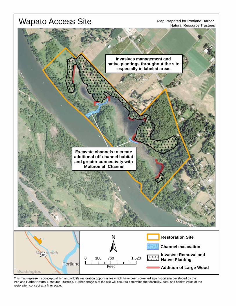
This map represents conceptual fish and wildlife restoration opportunities which have been screened against criteria developed by the Portland Harbor Natural Resource Trustees. Further analysis of the site will occur to determine the feasibility, cost, and habitat value of the restoration concept at a finer scale.
±
Map Prepared for Portland Harbor Natural Resource TrusteesWapato Access Site
Excavate channels to create additional off-channel habitat and greater connectivity with
Multnomah Channel
0 760 1,520380Feet
Restoration SiteChannel excavation
Addition of Large Wood
Invasive Removal and Native Planting
Invasives management and native plantings throughout the site
especially in labeled areas
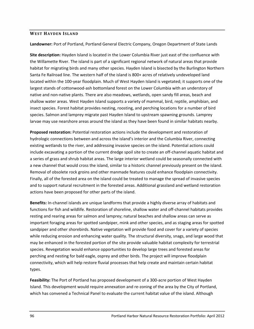
96 Portland Harbor Natural Resource Restoration Portfolio: April 2012
WE ST HAYD EN IS LA ND
Landowner: Port of Portland, Portland General Electric Company, Oregon Department of State Lands
Site description: Hayden Island is located in the Lower Columbia River just east of the confluence with
the Willamette River. The island is part of a significant regional network of natural areas that provide
habitat for migrating birds and many other species. Hayden Island is bisected by the Burlington Northern
Santa Fe Railroad line. The western half of the island is 800+ acres of relatively undeveloped land
located within the 100-year floodplain. Much of West Hayden Island is vegetated; it supports one of the
largest stands of cottonwood-ash bottomland forest on the Lower Columbia with an understory of
native and non-native plants. There are also meadows, wetlands, open sandy fill areas, beach and
shallow water areas. West Hayden Island supports a variety of mammal, bird, reptile, amphibian, and
insect species. Forest habitat provides nesting, roosting, and perching locations for a number of bird
species. Salmon and lamprey migrate past Hayden Island to upstream spawning grounds. Lamprey
larvae may use nearshore areas around the island as they have been found in similar habitats nearby.
Proposed restoration: Potential restoration actions include the development and restoration of
hydrologic connections between and across the island’s interior and the Columbia River, connecting
existing wetlands to the river, and addressing invasive species on the island. Potential actions could
include excavating a portion of the current dredge spoil site to create an off-channel aquatic habitat and
a series of grass and shrub habitat areas. The large interior wetland could be seasonally connected with
a new channel that would cross the island, similar to a historic channel previously present on the island.
Removal of obsolete rock groins and other manmade features could enhance floodplain connectivity.
Finally, all of the forested area on the island could be treated to manage the spread of invasive species
and to support natural recruitment in the forested areas. Additional grassland and wetland restoration
actions have been proposed for other parts of the island.
Benefits: In-channel islands are unique landforms that provide a highly diverse array of habitats and
functions for fish and wildlife. Restoration of shoreline, shallow water and off-channel habitats provides
resting and rearing areas for salmon and lamprey; natural beaches and shallow areas can serve as
important foraging areas for spotted sandpiper, mink and other species, and as staging areas for spotted
sandpiper and other shorebirds. Native vegetation will provide food and cover for a variety of species
while reducing erosion and enhancing water quality. The structural diversity, snags, and large wood that
may be enhanced in the forested portion of the site provide valuable habitat complexity for terrestrial
species. Revegetation would enhance opportunities to develop large trees and forested areas for
perching and nesting for bald eagle, osprey and other birds. The project will improve floodplain
connectivity, which will help restore fluvial processes that help create and maintain certain habitat
types.
Feasibility: The Port of Portland has proposed development of a 300-acre portion of West Hayden
Island. This development would require annexation and re-zoning of the area by the City of Portland,
which has convened a Technical Panel to evaluate the current habitat value of the island. Although
Portland Harbor Natural Resource Restoration Portfolio: April 2012 97
restoration of portions of West Hayden Island may provide habitat value, this restoration could be
impacted by the type and scale of activities associated with development that may eventually take place
(for example, a rail loop or spur). Recreation at the site could also limit or impact ecological benefits. In
terms of technical feasibility of the proposed restoration actions, the altered hydrologic regime of the
Lower Columbia and Willamette rivers due to regional dam operations is the most significant constraint
to restoration.
Other constraints/considerations: The Port has developed a suite of potential restoration designs on
500 acres of West Hayden Island. For purposes of this evaluation, the Trustees considered the potential
“lift” provided by restoration of all 800 acres, recognizing that the entire area may not ultimately be
available for restoration. This approach to evaluating the island’s restoration potential does not
represent a Trustee Council position on the question of re-zoning the island for development.
Portland Harbor Natural Resource Restoration Portfolio: April 2012 99
W IL LA METT E PA RK
Landowner: City of Portland, Oregon Department of State Lands
Site description: Located at river mile 15.75 on the west bank of the Willamette River, Willamette Park
is a 26-acre hybrid park that has both developed uses (boat ramp and dock, soccer fields, etc.) and
natural areas that include wetlands, bottomland hardwood forest, beaches, mudflats, and rock outcrop
islands. The site contains about 2,000 linear feet of riparian zone. Limiting habitat factors include
hardened and steepened banks, disconnected floodplain, high human use, and untreated stormwater
from the parking lot and boat launch.
Proposed restoration: The open spaces along the riverbank provide opportunities to restore steepened
and hardened banks, widen the riparian corridor and to create shallow water habitat. Restoration at this
site could include reducing bank slope and reducing the amount of hardened banks; improving the
connection between the river and the floodplain; increasing the amount of shallow water habitat;
increasing functional riparian and floodplain areas; and increasing the amount of large wood. There may
also be opportunities to create off-channel habitat.
Benefits: Some portions of Willamette Park have excellent existing shallow water habitat that can be
used as a reference for other shallow water restoration projects. The mudflats and rock outcrop islands
provide unique habitat for shorebirds and fish. Improvements in riparian and nearshore aquatic
habitats, banks and floodplains would improve rearing and refuge habitat for salmonids and enhance
important feeding, breeding and nesting habitat for native wildlife. Increasing and improving riparian
vegetation would increase available habitat and help stabilize stream banks; capture sediment in
stormwater runoff; support hydrologic flow processes and nutrient cycling; and provide a source of
woody material to the river.
Feasibility: Recreational use of the park, including the desire of park users for views of and access to the
water from the park, is a key challenge to effective habitat restoration. In addition, restoration design
will need to carefully avoid impacts to existing good-quality shallow water/mud flat habitat at the park.
Other constraints/considerations: BES is currently designing stormwater treatment retrofits for two
areas in the park. These projects would address stormwater from the boat launch and large parking
areas.