Embed Size (px)
Citation preview

ECOLOGICAL PRINCIPLESFOR MANAGING LAND USE
The Ecological Society of America�s Committee on Land Use
Key ecological principles for land use and management deal with time,species, place, disturbance, and the landscape. The principles result inseveral guidelines that serve as practical rules of thumb for incorporatingecological principles into making decisions about the land.
April 2000

INTRODUCTION
Humans are the major force of change around theglobe, transforming land to provide food, shelter, andproducts for use. Land transformation affects many ofthe planet�s physical, chemical, and biological systems anddirectly impacts the ability of the Earth to continueproviding the goods and services upon which humansdepend.
Unfortunately, potential ecological consequences arenot always considered in making decisions regarding landuse. In this brochure, we identify ecological principles thatare critical to sustaining ecosystems in the face of land-use change. We also offer guidelines for using theseprinciples in making decisions regarding land-use change.This brochure is the first of many activities under a LandUse Initiative of the Ecological Society of America.
CHALLENGES OF ECOLOGICALLYSUSTAINABLE LAND USE
A critical challenge for land use and managementinvolves reconciling conflicting goals and uses of the land.The diverse goals for use of the land include:• resource-extractive activities (e.g., forestry,
agriculture, grazing, and mining);• infrastructure for human settlement (housing,
transportation, and industrial centers);• recreational activities;• services provided by ecological systems (e.g, flood
control and water supply and filtration);• support of aesthetic, cultural, and religious values;
and• sustaining the compositional and structural complexity
of ecological systems.These goals often conflict with one another, and difficultland-use decisions may develop as stakeholders pursue
DEFINITIONS
Land cover: the ecological state and physical appearanceof the land surface (e.g., closed forests, open forests,grasslands).
Land use: the purpose to which land is put by humans(e.g., protected areas, forestry for timber products,plantations, row-crop agriculture, pastures, or humansettlements).
Ecosystem management: the process of land usedecision-making and land management practice that takesinto account the best available understanding of theecosystem�s full suite of organisms and natural processes.
Land management: the way a given land use isadministered by humans.
Ecological sustainability: the tendency of a system orprocess to be maintained or preserved over time withoutloss or decline.
Biodiversity: the variety of life and ecological systemsat scales ranging from populations to landscapes.
Habitat fragmentation: the alteration of previouslycontinuous habitat into spatially separate, smaller patches.
different land-use goals. Local versus broad-scaleperspectives on the benefits and costs of land managementalso provide different views. In this brochure, we focus onsustaining ecological systems which also indirectly supportsother values, including ecosystem services, cultural andaesthetic values, recreation, and sustainable extractive usesof the land.
To meet the challenge of sustaining ecological systems,an ecological perspective should be incorporated into land-use and land-management decisions. Specifying ecologicalprinciples and understanding their implications for land-use and land-management decisions are essential steps onthe path toward ecologically based land use.
Key ecological principles deal with time, species, place,disturbance, and the landscape. While they are presentedas separate entities, the principles interact in many ways.
TIME PRINCIPLE
Ecological processes function at many time scales,some long, some short; and ecosystems change throughtime. Metabolic processes occur on the scale of secondsto minutes, decomposition occurs over hours to decades,and soil formation occurs at the scale of decades tocenturies. Additionally, ecosystems change from seasonto season and year to year in response to variations inweather as well as showing long-term successionalchanges. Human activities can alter what makes up anecosystem or how biological, chemical, and geological
2
Few alterations of the land surface are as profound ashuman settlement.

materials flow through an ecosystem. These in turn canchange the pace or direction of succession and have effectslasting decades to centuries.
The time principle has several important implicationsfor land use:• The current composition, structure, and function of
an ecological system are, in part, a consequence ofhistorical events or conditions and current land usesmay limit land use options that are available in thefuture.
• The full ecological effects of human activities oftenare not seen for many years.
• The imprint of a land use may persist on thelandscape for a long time, constraining future landuse for decades or centuries even after it ceases.
• Long-term effects of land use or management maybe difficult to predict due to variation and change inecosystem structure and process. This problem isexacerbated by the tendency to overlook low-frequency ecological disturbances, such as 100-yearflooding, or processes that operate over periods longerthan human life spans (e.g., forest succession).
SPECIES PRINCIPLE
Particular species and networks of interactingspecies have key, broad-scale ecosystem-level effects.These focal species affect ecological systems in diverseways:• Indicator species tell us about the status of other
species and key habitats or the impacts of a stressor.• Keystone species have greater effects on ecological
processes than would be predicted from theirabundance or biomass alone.
• Ecological engineers [e.g., the gopher tortoise orbeaver] alter the habitat and, in doing so, modify thefates and opportunities of other species.
• Umbrella species either have large area requirementsor use multiple habitats and thus overlap thehabitat requirements of many other species.
• Link species exert critical roles in the transfer of matterand energy across trophic levels (of a food web) orprovide critical links for energy transfer within complexfood webs.The impacts of changes in the abundance and
distribution of focal species are diverse. For example,keystone species affect ecosystems through such processesas competition, mutualism, dispersal, pollination, anddisease and by modifying habitats and abiotic factors. An
LEGACY OF PAST LAND USE ON
ECOSYSTEM DEVELOPMENT
Past land use can constrain or control futureecosystem development. For example, the currentcomposition of forests in parts of New England is aresult of past patterns and practices in agriculture andforestry. During the 18th and 19th centuries, most ofthe forests in New England were either cleared foragriculture or harvested for wood products. By thelate 19th century, agricultural lands were neglected,and forests regrew. However, current forestcomposition shows the imprint of past land use.
In a sand plain in Massachusetts, forests of pitchpine occur almost exclusively on formerly plowed lands;in contrast, stands of scrub oak occur mostly on sitesthat had not been plowed. Paleoecological evidencesuggests that pre-European fires were common onthese sand plains. The impacts of fire and prior landuse interact. Fire influences vegetation patterns in thesand plain of New England and can explain some of thedramatic changes in land cover that have occurred.When fire was controlled, pitch pine establishmentrequired the exposed mineral soil and open canopyconditions that existed on formerly plowed sites. Themodern vegetation on the sand plain is a result ofcomplex human-impacted disturbance histories, withfire modifying the composition of species assemblagesthat developed as a result of prior land use.
3
Past land use, topography, and dominant and introducedspecies are partially responsible for patterns of land cover.
Many ecological processes, such as forest growth anddecomposition, are on time scales much longer than ahuman lifetime.

introduced, nonnative species can assume a focal-speciesrole and produce numerous effects, including alteringcommunity composition and ecosystem processes via theirroles as predators, competitors, pathogens, or vectors ofdisease and, through effects on water balance, productivity,and habitat structure. The impacts of land use changeson keystone and invasive species can spread well beyondthe boundaries of the land-use unit and are difficult topredict prior to changes in their abundance. Changes inthe pattern of land cover can affect, and even promote,the establishment of nonnative species.
Trophic levels refer to the stages in food chains suchas producers, herbivores, consumers, and decomposers.Changes in the abundance of a focal species or group oforganisms at one trophic level can cascade across othertrophic levels and result in dramatic changes in biologicaldiversity, community composition, or total productivity.Changes in species composition and diversity can result
from land use through alterations to such ecosystemproperties as stream flow or sediment load, nutrient cycling,or productivity. The effects of land use on speciescomposition have implications for the future productivityof ecological systems.
PLACE PRINCIPLE
Local climatic, hydrologic, soil, and geomorphologicfactors as well as biotic interactions strongly affectecological processes and the abundance and distributionof species at any one place. Local environmentalconditions reflect location along gradients of elevation,longitude, and latitude and the multitude of microscalephysical, chemical, and edaphic factors that vary withinthese gradients. These factors constrain the suitability ofvarious land uses, as well as defining resident species andprocesses.
LINKAGES AMONG SPECIES
Insect pollinators are a keystone group of species because more than two-thirds of flowering plants require them forsuccessful reproduction. A reduction in pollinators can lead to reduced seed set and less viable offspring, subsequentlyaffecting other species that feed on plant seeds or fruits. Changes in land use and management have negatively affectedplant pollinators in many places. In both North America and Europe, pollinator density decreases as the proportion of anarea occupied by agriculture increases, presumably because conversion of land to agriculture or urban areas reduces theamount of native food plants used by pollinators. Similarly, habitat fragmentation and pesticide use can reduce or eliminatepollinator populations.
The redcockaded woodpecker is an example of a keystone species that affects the habitats of other organisms. It livesin the longleaf pine/wire grass ecosystem of the southeastern United States, which severely declined between 1880 and1986. These birds nest in mature longleaf and loblolly pine trees and excavate nest cavities in living trees. Redcockadedwoodpeckers are key components because numerous other species rely on their nest cavities. These other animals havebeen reduced in abundance over the past century as populations of the woodpecker have declined with a reduction inpine-forest habitat by timber harvest and conversion to agriculture.
Introduced species may affect the composition and structure of systems in which they become established. Followingthe conversion of land to agriculture in the late 19th century, salt cedar was introduced into the western United States toprovide windbreaks and to prevent soil erosion. Salt cedar invaded water drainages, riparian ecosystems, and wetlandhabitat over much of western North America. Its dominance in such habitats results in reduced plant and animal diversity;increased evapotranspiration; a lower water table; increased soil salinity; and, possibly, altered nutrient cycling.
4

Rates of key ecosystem processes, such as primaryproduction and decomposition, are limited by soil nutrients,temperature, water availability, and the temporal patternof these factors controlled by climate and weather. Thus,only certain ranges of ecological-process rates can persistin a locale without continued management inputs (e.g.,irrigation of crops growing in a desert). Chronic humanintervention may broaden these ranges but cannot entirelyevade the limitations of place without a cost.
Naturally occurring patterns of ecosystem structureand function provide models that can guide sustainableand ecologically sound land use. Only those speciesadapted to the environmental constraints of an area willthrive there. Precipitation limits which species areappropriate for landscape plantings as well as for managedagricultural, forestry, or grazing systems. Further, someplaces with unique conditions may be more important thanothers for conservation of the species and ecosystems theysupport.
Land uses that cannot be maintained within theconstraints of place will be costly when viewed from long-term and broad-scale perspectives. For example,establishing croplands and ornamental lawns in arid areasis possible, but draws down fossil groundwater at a rateunsustainable by natural recharge. Only certain patternsof land use, settlement and development, buildingconstruction, or landscape design are compatible with localand regional conditions. In terrestrial systems, land-useand land-management practices that lead to soil loss or
degradation reduce the longterm potential productivityof a site and can affect species composition. Land usepractices can also influence local climate (e.g., the urbanheat island concept). Sustainable settlement is limited tosuitable places on the landscape. For instance, houses orcommunities built on transient lake shore dunes, majorflood plains, eroding seashores, or sites prone to fires arehighly vulnerable to loss over the long term. Ideally, theland should be used for the purpose to which it is bestsuited.
DISTURBANCE PRINCIPLE
The type, intensity, and duration of disturbanceshape the characteristics of populations, communities,and ecosystems. Disturbances are events that disruptecological systems; they may occur naturally [e.g.,wildfires, storms, or floods] or be induced by humanactions, such as clearing for agriculture, clearcutting inforests, building roads, or altering stream channels. Theeffects of disturbances are controlled in large part by theirintensity, duration, frequency, timing, and the size andshape of the area affected. Disturbances may affect bothabove- and below-ground processes and can impactcommunities and ecosystems by changing the number andkinds of species present; causing inputs or losses of deadorganic matter and nutrients that affect productivity and
USING LAND WITHIN THE CONSTRAINTS OF
PLACE: AGRICULTURAL ECOLOGY
For centuries, native peoples of the desertsouthwestern United States sustained agriculturalproduction by using both wild desert plants anddomesticated relatives of desert-adapted plants in areaswith limited water and soil nutrients. They maintainedproduction under conditions that would cause failureof plants not so adapted. These traditional agriculturalsystems indicate the value of using the landscape in away consistent with sustainable ecosystem function.
Native Americans of the southwest also locatedagricultural areas across the landscape in a way thattook advantage of local variation in water availabilityand soils. For instance, crops were planted on floodplains following the pattern of emergence of desertannual plants after seasonal rainfall. These areas of thelandscape received regular inputs of silt as well as water,and the flowering and fruiting of the native annualsprovided cues to the best times for agricultural plantingand production. The interspersion of well-placedpatches of agriculture with natural vegetation alsoincreased access to a reliable pool of pollinators andsoil mutualists, such as bacteria and mycorrhizal fungi,that were adapted to local soils and plants.
5
The concrete and steel of cities retains heat creating �ur-ban heat islands� and changing the microclimate of theurban area.
habitat structure; and creating landscape patterns thatinfluence many ecological factors, from movements anddensities of organisms to functional attributes ofecosystems.
Land-use changes that alter natural-disturbanceregimes or initiate new disturbances are likely to causechanges in species� abundance and distribution, communitycomposition, and ecosystem function. In addition, thesusceptibility of an ecosystem to other disturbances maybe altered.
Land managers and planners should be aware of theprevalence of disturbance in nature. Disturbances that areboth intense and infrequent, such as hurricanes or 100-yrfloods, will continue to produce �surprises.� Ecosystemschange, with or without disturbance; thus, attempts tomaintain landscape conditions in a particular state will befutile over the long term. Attempts to control disturbancesare general ly ineffectual and suppression of anatural disturbance may have the opposite effect of thatintended. For example, suppression of fire in fire-adaptedsystems results in the buildup of fuels and increases thelikelihood of severe, uncontrollable fires. Similarly, flood-
control efforts have facilitated development in areas thatare still subject to infrequent large events (e.g., the 1993floods in the upper Midwest), resulting in tremendouseconomic and ecological impacts. Land-use policy that isbased on the understanding that ecosystems are dynamicin both time and space can often deal with changes inducedby disturbances.
Understanding natural disturbances can help guideland-use decisions, but the differences between naturaland human-made disturbances must be recognized.Continued expansion of human settlement intodisturbanceprone landscapes is likely to result in increasedconflicts between human values and the maintenance ofnatural-disturbance regimes necessary to sustainsuch landscapes.
LANDSCAPE PRINCIPLE
The size, shape, and spatial relationships of land-cover types influence the dynamics of populations,communities, and ecosystems. The spatial arrangementof ecosystems comprises the landscape and all ecologicalprocesses respond, at least in part, to this landscapetemplate. The kinds of organisms that can exist are limitedby the sizes, shapes, and patterns of habitat across alandscape.
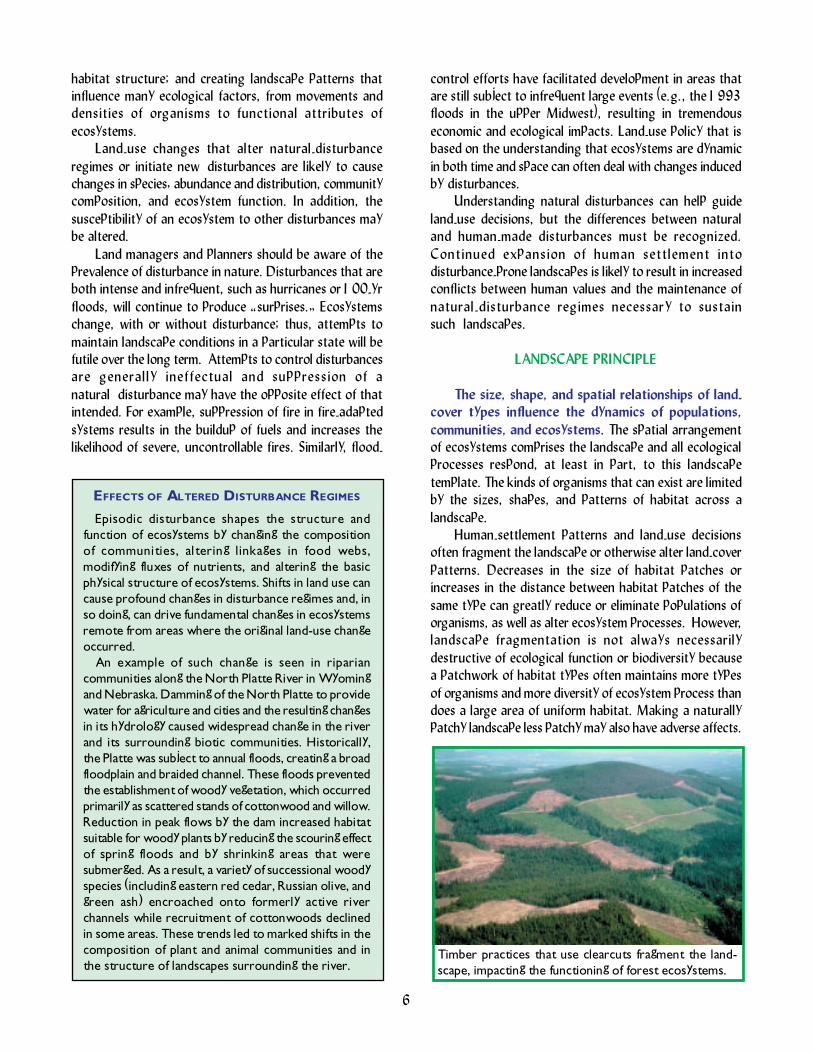
Human-settlement patterns and landuse decisionsoften fragment the landscape or otherwise alter land-coverpatterns. Decreases in the size of habitat patches orincreases in the distance between habitat patches of thesame type can greatly reduce or eliminate populations oforganisms, as well as alter ecosystem processes. However,landscape fragmentation is not always necessarilydestructive of ecological function or biodiversity becausea patchwork of habitat types often maintains more typesof organisms and more diversity of ecosystem process thandoes a large area of uniform habitat. Making a naturallypatchy landscape less patchy may also have adverse affects.
EFFECTS OF ALTERED DISTURBANCE REGIMES
Episodic disturbance shapes the structure andfunction of ecosystems by changing the compositionof communities, altering linkages in food webs,modifying fluxes of nutrients, and altering the basicphysical structure of ecosystems. Shifts in land use cancause profound changes in disturbance regimes and, inso doing, can drive fundamental changes in ecosystemsremote from areas where the original land-use changeoccurred.
An example of such change is seen in ripariancommunities along the North Platte River in Wyomingand Nebraska. Damming of the North Platte to providewater for agriculture and cities and the resulting changesin its hydrology caused widespread change in the riverand its surrounding biotic communities. Historically,the Platte was subject to annual floods, creating a broadfloodplain and braided channel. These floods preventedthe establishment of woody vegetation, which occurredprimarily as scattered stands of cottonwood and willow.Reduction in peak flows by the dam increased habitatsuitable for woody plants by reducing the scouring effectof spring floods and by shrinking areas that weresubmerged. As a result, a variety of successional woodyspecies (including eastern red cedar, Russian olive, andgreen ash) encroached onto formerly active riverchannels while recruitment of cottonwoods declinedin some areas. These trends led to marked shifts in thecomposition of plant and animal communities and inthe structure of landscapes surrounding the river.
6
Timber practices that use clearcuts fragment the land-scape, impacting the functioning of forest ecosystems.

Larger patches of habitat generally contain morespecies (and often a greater number of individuals) thansmaller patches of the same habitat. Larger patches alsofrequently contain more local environmental variability. Thisvariability provides more opportunities for organisms withdifferent requirements and tolerances to find suitable siteswithin the patch. In addition, the edges and interiors ofpatches may have quite different conditions, favoring somespecies over others. The abundance of edge and interiorhabitat varies with patch size; large patches are likely tocontain both edge and interior species, whereas smallpatches will contain only edge species.
The extent and pattern of habitat connectivity canaffect the distribution of species by making some areasaccessible and others inaccessible. The amount ofconnectivity needed varies among species and depends ontwo factors: the abundance and spatial arrangement ofthe habitat and the movement capabilities of the organism.
While gradual reduction in habitat may have gradualeffects, once a certain threshold is reached, the effectsbecome dramatic. Land-cover changes are most likely tohave substantial effects when habitat is low to intermediatein abundance and small changes may cause large impacts.
The ecological importance of a habitat patch may bemuch greater than is suggested by its size and distributionacross the landscape. Some habitats, such as bodies ofwater or riparian corridors, are small and discontinuous,but nevertheless have ecological impacts that greatlyexceed their spatial extent. For example, the presence ofriparian vegetation, which may occur as relatively narrowbands along a stream or as small patches of wetland,generally reduces the amount of nutrients beingtransported to the stream. This filtering by the vegetationis an ecologically important function because excessnutrients that unintentionally end up in lakes, streams,and coastal waters are a major cause of eutrophication,acidification, and other water quality problems. Thus, thepresence and location of particular vegetation types canstrongly affect the movement of materials across thelandscape and can contribute to the maintenance ofdesirable water quality.
GUIDELINES FOR LAND USE
Ecologically based guidelines are proposed here as away to assist land managers and others considering theecological ramifications of land-use decisions. Theseguidelines are meant to be flexible and to apply to diverseland-use situations. The guidelines recognize that the sameparcel of land can be used to accomplish multiple goalsand emphasize that decisions should be made within an
WOLVES IN A HUMAN-DOMINATED LANDSCAPE
The status and future of wide-ranging animals inregions increasingly dominated by humans is often aconcern to natural-resource managers. Recovery ofthe gray wolf, listed in 1973 as an endangered species,illustrates this challenge. The wolf was extirpatedthroughout most of the conterminous U.S. followingEuropean settlement, with remnant populationspersisting only in northeast Minnesota and on IsleRoyale, Michigan.
Natural recolonization in the western Great Lakesregion has led to recovery of wolf populations, and theWisconsin and Michigan populations each numberbetween 80 and 90 animals. Wolf recovery resultedlargely from legal protection and changed publicattitudes. In addition, large populations of deer, resultingin part from the fragmented forest landscapes typicalof the region today, provide a ready source of prey.But how do the current landscape patterns in thishuman-dominated region influence the wolf habitat andpopulations?
Wolf habitat use is affected by a number oflandscape-scale considerations. Wolves avoided certainlandcover classes, such as agriculture and deciduousforests, and favored forests with at least some conifers.Public lands received more use, and private lands wereavoided. Wolf packs were also most likely to occur inareas with low road densities; no wolfpack territorywas bisected by a major highway. Rapid increases inthe wolf population since 1993 have occurred innorthern Michigan, where favorable habitat is moreabundant and more highly connected than in Wisconsin.In Wisconsin, favorable wolf habitat occurs in relativelysmall, isolated areas separated by lands with greaterroad density and human development. Adult mortalityin Wisconsin has been high, with dispersing wolvesbeing most vulnerable as they cross lands with moreintensive human use. Colonization of the fragmentedhabitat in Wisconsin may remain dependent ondispersers arriving from larger, saturated populationsin Minnesota.
7

appropriate spatial and temporal context. For example,the ecological implications of a decision may last fordecades or even centuries.
All aspects of a decision need to be considered insetting the time frame and spatial scale for impact analysis.In specific cases, the relevant guidelines can be developedinto prescriptions for action. These guidelines are best seenas a checklist of factors to be considered in making aland-use decision.
Examine Impacts of Local Decisionsin a Regional Context
The spatial array of habitats and ecosystems shapeslocal conditions and responses and local changes can havebroad-scale impacts over the landscape. Therefore, it iscritical to examine both the limitations placed on a locationby the regional conditions and the implications of decisionsfor the larger area. This guideline suggests twoconsiderations for planning land use:� identify the surrounding region that is likely to affect
and be affected by the local project and� examine how adjoining jurisdictions are using and
managing their lands.Once the regional context is identified, examine regionaldata (e.g., land-cover classes, soils, patterns of watermovement, historical disturbance regimes, and habitatsof focal species and other species of special concern).Recent technological advances [such as the developmentof geographic information systems (GIS) and the generalavailability of databases for soils, roads, and land coveron the Internet] make regional analysis a possibility evenfor small projects.
Some land uses offer more flexibility in terms of futureor adjoining uses than do others. The ecological constraintsof an area determine the flexibility of diverse land uses forthat area. This guideline calls for examining local decisionswithin the regional context of ecological concerns as wellas in relation to the social, economic, and politicalperspectives that are typically considered.
Plan for Long-Term Changeand Unexpected Events
Impacts of land-use decisions can, and often do, varyover time. Long-term changes that occur as a response toland-use decisions can be classified into two categories:� Delayed impacts may not be observed for years or
decades. An example is the composition of forestcommunities in New England; today, those forestsdiffer substantially depending on whether they werepreviously woodlots, pasture, or croplands.
� Cumulative effects are illustrated by events thattogether determine a unique trajectory of effects thatcould not be predicted from any one event. Forexample, at Walker Branch Watershed in EastTennessee, patterns of calcium cycling are determinednot only by past land uses (timber harvest versusagriculture) but also by the history of insect outbreaksin the recovering forest.Land-use decisions should be implemented with some
consideration as to the physical, biological, aesthetic oreconomic constraints they will place on future uses of theland. External effects, which can extend beyond theboundaries of individual ownership and affect surroundingowners, must also be considered.
8
ECOLOGICAL GUIDELINES FOR LAND USE
· Examine the impacts of local decisions in a regional context.
· Plan for long-term change and unexpected events.
· Preserve rare landscape elements, critical habitats, and associated species.
· Avoid land uses that deplete natural resources over a broad area.
· Retain large contiguous or connected areas that contain critical habitats.
· Minimize the introduction and spread of nonnative species.
· Avoid or compensate for effects of development on ecological processes.
· Implement land-use and -management practices that are compatible with the natural potentialof the area.

Planning for the long term requires consideration ofthe potential for unexpected events, such as variations intemperature or precipitation patterns or disturbances.Estimating the occurrence and implications of theseunanticipated events is difficult, but land-use plans shouldattempt to include them and estimate likely changes.
Long-term planning should also recognize that onecannot simply extrapolate historical land-use impactsforward to predict future consequences of land use.Transitions of land from one use or cover type to anotheroften are not predictable because of changes indemographics, public policy, market economies, andtechnological and ecological factors.
Preserve Rare Landscape Elementsand Associated Species
Rare landscape elements provide critical habitats orecological processes. For example, in the SouthernAppalachian Mountains, 84% of the federally-listedterrestrial plant and animal species occur in rarecommunities. While these communities occupy a small areaof land, they contain features important for the region�sbiological diversity. Therefore, rare landscape elements needto be identified, usually via an inventory and analysis ofvegetation types, physical features, hydrology, soils, andassociated species. Once the inventory is complete, effectsof land-use decisions on these landscape elements andspecies can be routinely estimated. These effects can thenbe considered in view of the overall goal for the project,the distribution of elements and species across thelandscape, and their susceptibility, given likely future landchanges in the vicinity and region. Strategies to avoid ormitigate serious impacts can then be developed andimplemented.
Avoid Land Uses that Deplete NaturalResources over a Broad Area
Depletion of natural resources disrupts naturalprocesses in ways that often are irreversible over longperiods of time. The loss of soil via erosion that occursduring agriculture and the loss of wetlands and theirassociated ecological processes and species are twoexamples. To prevent diminishment, those resources atrisk must first be determined. For example, in thesouthwestern United States, water might be the mostimportant resource. Evaluation of whether a resource isat risk is an ongoing process as the abundance anddistribution of resources change. Ways to avoid actionsthat would jeopardize natural resources should be identifiedand considered. Some land actions are inappropriate in aparticular setting or time, and they should be avoided.Examples are farming on steep slopes, which might producesoil loss; logging, grazing, or farming too close tostreambanks, which may jeopardize water quality andaquatic habitats; and growing plants with high waterdemands in arid areas.
Retain Large Contiguous or Connected Areasthat Contain Critical Habitats
Large areas are often important to maintaining keyorganisms and ecosystem processes. Habitat patch size iscritical to the survival of a species or population when it israre or disconnected. In most parts of the nation, largeareas of natural habitats are becoming less common asthey are fragmented into smaller habitat patches suitablefor fewer species. A useful management approach generallyfavors protecting large areas and smaller areas that arewell-connected to other habitats.
Habitat connectivity is not always a positive attributefor species and ecosystems. Land uses that serve asconnectors to species� movement can have long-termpositive effects on populations; but, at the same time,corridors can facilitate the spread of nonnative species ordiseases.
9
Land uses such as grazing should be managed so as notto jeopardize natural resources and systems.
Lands can be managed for human use and to serve aswildlife corridors and habitats.

10
The importance of spatial connections depends on thepriorities and elements of a situation. A first step inimplementing this guideline is to examine the spatialconnectivity of key habitats in an area, determining whichpatches are connected and whether the connectivity varieswith time. Second, opportunities for connectivity must bepromoted. Sometimes, those opportunities can complementother planning needs.
Minimize the Introduction andSpread of Nonnative Species
Nonnative organisms often have negative effects onnative species and the structure and functioning ofecological systems. Land-use decisions must consider thepotential for the introduction and spread of nonnativespecies. For example, kudzu, first used for erosion control,is now overwhelming and killing native trees. Land planningshould consider vehicle movement along transportation
ASSESSING LOCAL CONDITIONS
The purpose of land-use planning is to ensure that important societal attributes are sustained. These attributes fallinto three groups: infrastructure (e.g., jobs, roads, schools, and firehouses), environmental resources (e.g., open spaces,parks, watersheds, natural areas, and wetlands), and public safety (e.g., avoidance of flood plains, unstable soils, and firehazards). Land-use planning typically follows several steps in balancing emphasis on these attributes.
First, data on current local conditions are assembled. On the basis of these data, concerns about impacts of developmentare identified. Then, goals for maintaining values are formulated, and criteria for meeting those goals are specified. Alternativeapproaches to meeting the goals (e.g., regulations, incentives, or public purchase) are developed, and the best are selectedand implemented. The success of the chosen approach is then evaluated relative to the criteria. This evaluation becomespart of the data used in the next iteration of the planning process.
An important step in land-use planning is trying to ascertain how a proposed use will affect current local conditions.A process for identifying the effects of development on wildlife habitat and natural communities in Larimer County,Colorado, provides an example. The process was initiated by assembling a group of stakeholders to work with ecologiststo identify areas of the landscape that needed to be protected. This group included developers, landowners, planners,environmental advocates, and decision makers. The participation of stakeholders was important for several reasons. First,no single �ecological standard� can be used to assess the value of one facet of the landscape relative to another. Ultimately,ecological knowledge must be combined with local values to arrive at such assessments. Second, the support of leaders ofgroups affected by the process must be enlisted.
The stakeholder group identified four landscape features based on importance to biological conservation and availabilityof spatial data about the features:
1) areas with one or more imperiled species,2) habitat for economically important species,
These features were mapped, and a composite map was created showing all of the county as falling into one or more of thefour categories. This map was used to designate areas that required a �Habitat Mitigation Plan.� As a requirement forapproval of all proposed developments, these plans outline procedures for on-the-ground verification and assessment ofthe condition of these environmental features. If the features are determined to be at risk with the proposed land use,then steps must be taken to mitigate the effects of development. Such steps include provision of setbacks, enforcement ofspecial regulations and covenants, and transfer of development rights from other areas.
Developers can specify an area in the County and learn if it contains environmentally sensitive areas before preparinga development proposal, increasing the chances that sensitive areas will be avoided by choice rather than by regulation.Alternatively, citizen advocates can learn where development is proposed and can attend review hearings with the supportof the best available data on the environmental impacts of the development under review. This mechanism allows theassessment of local conditions to be a dynamic, ongoing process, rather than a static snapshot in time.
3) areas of high species richness, and4) rare plant communites.
Initially planted to stabilize erosion on roadside banks,the non-native plant, kudzu, takes over a hill side, cov-ering shrubs and trees.

11
routes, the planting of native species, and control of pets.For example, the spread of the gypsy moth is correlatedwith overseas transportation of eggs, larvae, and adultsin the cargo holds of ships or along roads when egg sacsare attached to vehicles or outdoor furniture. Theintroduction of aquatic organisms (e.g., the zebra mussel)transported incidentally with shipping traffic is acomparable example for aquatic ecosystems. Many of theseintroductions have had devastating effects.
Growing native species can reduce the need forplanting nonnative species, particularly in urban, suburban,or other developed areas. The planted native species canthen reseed themselves. Native species are also adaptedto long-term variations in climate or disturbance regimesto which nonnative species often succumb. Environmentalconditions associated with native vegetation may also deterthe spread of nonnatives.
Avoid or Compensate for Effects ofDevelopment on Ecological Processes
Negative impacts of development might be avoidedor mitigated by some forethought. To do so, potentialimpacts need to be examined at the appropriate scale. Ata fine scale, the design of a structure may interruptecoregional processes, while at a broad scale, patterns ofwatershed processes may bealtered, for example, bychanging drainage patterns asa result of development. Howproposed actions might affectother systems (or lands) shouldbe examined. Human uses ofthe land should avoidstructures and uses that mighthave a negative impact onother systems; at the veryleast, ways to compensate forthose anticipated effects shouldbe determined. It is useful tolook for opportunities to designland use to benefit or enhancethe ecological attributes of a region. For example, partsof golf courses can be designed to serve as wildlife habitat,or traffic in rural areas can be concentrated on fewer andmore strategically placed roads, resulting in decreasedtraffic volumes and flows within the region as a whole andless impact on wildlife.
Implement Land-Use and -Management Practices thatare Compatible with the Natural Potential of the Area
Because local physical and biotic conditions affectecological processes, the natural potential for productivity
and for nutrient and water cycling partially determine theappropriate land-use and -management practices for a site.Land-use practices that fall within these place limits areusually cost-effective in terms of human resources andfuture costs caused by unwarranted changes on the land.Implementing land-use and -management practices thatare compatible with the natural potential of the arearequires that land managers have an understanding of thesite potential.
MAKING SUSTAINED PROGRESS
Much progress has been made in managing land inecologically sustainable ways. However, more actions areneeded before ecologically based land management isbroadly implemented. These guidelines must be translatedto particular land uses. This translation can be done, forexample, by using these principles and guidelines to shapemunicipal ordinances for land use practices. In addition,these guidelines can provide the basis for specifying andunderstanding ecological concerns relevant to the needsof specific types of land users, such as farmers or foresters.
These guidelines do not address the environmental,social, economic, and political tradeoffs that often occurin setting land policy. Tradeoffs are often based on
subjective value judgmentsreflecting economic, social,cultural, and aestheticpreferences accorded by asociety to different objectivesand variation in localcircumstances. For example,consideration of such tradeoffsare central components ofland-use agreements in therestoration of the Evergladesand in developing options forfisheries and ancient forests inthe Pacific Northwest.
However, society and theecological community have not
yet converged on a consistently applicable mechanism forincorporating science into land-use policy. Positive stepsin integrating scientific ideas and land-use managementare being taken at both the international and nationalscales. At the local scale, an unprecedented increase innumbers of watershed alliances and other types ofnongovernmental organizations has occured in responseto the perception that government agencies are not doingenough to manage the land sustainably. In each case,science is only a part of the solution, although an essentialpart.
Urban gardens are a method of returning some ecosys-tem services to degraded urban lands.

ACKNOWLEDGEMENTS
The ESA Land Use Committee would like to acknowledge those who contributed to the production of this brochure. Wewould like to thank Doug Norton, Bill Painter, and Jessica Cogan, U.S. Environmental Protection Agency, for reviewing andproviding comments on the brochure as it developed. We acknowledge and appreciate the skills of Lori Hidinger in developingthis brochure. We would also like to acknowledge the following for the photographs used in the brochure: V. Dale (ORNL),J. Franklin (UWash), K. Hammond (USDA), J. Hanula and K. Franzreb (USGS), R. Mieremet (NOAA), S. Smith (UNLV), W.Tarpenning (USDA), and K. Weller (USDA). Finally, we would like to gratefully thank the U.S. Environmental ProtectionAgency for funding the production of this brochure.
FOR MORE INFORMATION
This brochure is based on an Ecological Society of America White Paper, �Ecological Principles and Guidelines for Managingthe Use of Land,� published in Ecological Applications, Volume 10, Number 3 (June 2000). The White Paper is alsoavailable on the ESA website at http://esa.sdsc.edu/esalanduse.htm.
ESA COMMITTEE ON LAND USE
The authors of the White Paper upon which this brochure is based served as members of the ESA Committee on Land Use:Virginia H. Dale, Environmental Sciences Division, Oak Ridge National Laboratory, Oak Ridge, TN 37831-6036;Sandra Brown
1, University of Illinois, Champaign, Illinois;
Richard A. Haeuber2, Sustainable Biosphere Initiative, Ecological Society of America, Washington, DC 20036;
N. Thompson Hobbs, Colorado Division of Wildlife and Natural Resource Ecology Laboratory, Colorado State University, Fort Collins,CO 80523;
Nancy J. Huntly, Department of Biological Sciences, Idaho State University, Pocatello, ID 83209-8007;Robert J. Naiman, College of Ocean and Fishery Sciences, University of Washington, Seattle, WA 98195-2100;William E. Riebsame, Department of Geography, University of Colorado, Boulder, CO 80309;Monica G. Turner, Department of Zoology, University of Wisconsin, Madison, WI 53706;Tom J. Valone
3, Department of Biology, California State University, Northridge, CA 91330-8303.
1 current address: Winrock International, 1611 North Kent Street, Suite 600, Arlington, VA 22209
2 current addres: 1712 Johnson Avenue, NW, Washington, DC 20009
3 current address: Department of Biology, St. Louis University, St. Louis, MO 63103
Founded in 1915, the Ecological Society of America is the nation�s leading professional society of ecologists, representing over7,300 members in the United States, Canada, Mexico, and 62 other nations.
The purpose of the Society is to:� promote ecological science by improving communication among ecologists;� raise the public�s level of awareness of the importance of ecological science;� increase the resources available for the conduct of ecological science; and� ensure the appropriate use of ecological science in environmental decision making by enhancing communication between
the ecological community and policy makers.
Working together toward these common goals, the Publications, Sustainable Biosphere Initiative Project, and the Public AffairsOffices draw upon the scientific expertise of the Society�s membership.
Additional copies of this brochure can be obtained for $4 each by contacting:Ecological Society of America1707 H Street, NW Suite 400
Washington, DC [email protected]
12