Embed Size (px)
Citation preview
Ecohydrology of karst
poljes and their
vulnerability
Prof. emeritus O. Bonacci Faculty of Civil Engineering, Architecture and Geodesy, Split
University, 21000 Split, Matice hrvatske 15, Croatia
E-mail: [email protected]

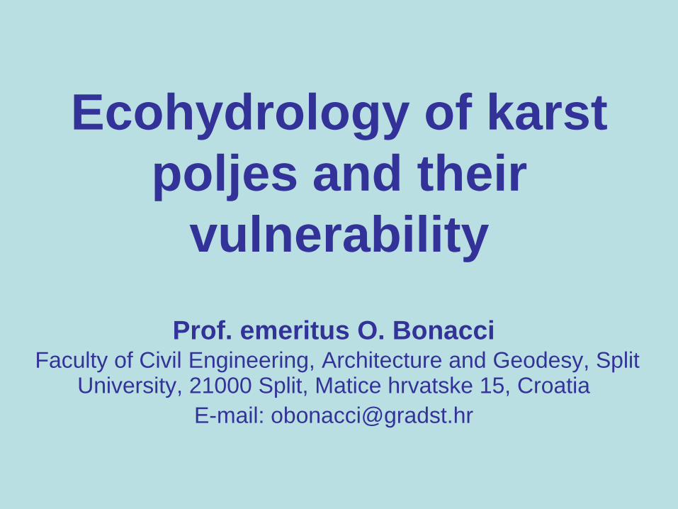
Swallow-hole opened at
the bottom of the
Boljunčica reservoir
through sediment
deposit
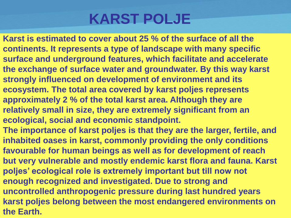
Karst is estimated to cover about 25 % of the surface of all the
continents. It represents a type of landscape with many specific
surface and underground features, which facilitate and accelerate
the exchange of surface water and groundwater. By this way karst
strongly influenced on development of environment and its
ecosystem. The total area covered by karst poljes represents
approximately 2 % of the total karst area. Although they are
relatively small in size, they are extremely significant from an
ecological, social and economic standpoint.
The importance of karst poljes is that they are the larger, fertile, and
inhabited oases in karst, commonly providing the only conditions
favourable for human beings as well as for development of reach
but very vulnerable and mostly endemic karst flora and fauna. Karst
poljes’ ecological role is extremely important but till now not
enough recognized and investigated. Due to strong and
uncontrolled anthropogenic pressure during last hundred years
karst poljes belong between the most endangered environments on
the Earth.
KARST POLJE

Karst polje as the geomorphological term refers to large
closed depressions with conspicuously flat bottoms
developed on karst rocks.
Their areas vary from less than 0.5 km2 to more than 500
km2, and exhibit complex hydrological and
hydrogeological features and characteristics.
Geomorphological and hydrogeological features of
poljes, mainly flat surface covered by impermeable soil,
make possible formation of permanent as well as
temporary streams and lakes, which enable development
of reach biological forms in and around them. Poljes can
be divided into the following groups according to the
hydrological regime: (1) permanently flooded or lakes;
(2) periodically, partly, or completely flooded; and (3) dry
poljes.


As a consequence of intensive
tectonic activity the poljes in Dinaric
karst have been formed as terraces
from an altitude of more than 1000 m
above sea level to the sea level. They
represent more or less
interconnected subsystems within
the process of surface and
groundwater flow through the karst
spring catchment. From the
hydrologic–hydrogeologic
perspective, a polje is to be
considered as part of a wider
system. It cannot be treated as an
independent system.

System of 7 karst
poljes in the
Ljubljanica River
springs
catchment

Developing the research interface between hydrology
and ecology has been recognised as a research
frontier in geosciences. Despite a history of research
that integrates insight from the two scientific
disciplines, they still operate somewhat independently
with different philosophies, conceptual frameworks,
terminology and experimental approaches.
Harte (2002) seeks a synthesis of what he calls the
Newtonian and Darwinian approaches to science. He
believes that such a synthesis offers opportunities for
progress at the intersection of physics and ecology
where many critical issues in earth system science
reside.
ECOHYDROLOGY !?

The pattern and intensity of hydrological variability
significantly influences on biotic structure and activity.
On the other hand, biotic structures can regulate
abiotic ones. As a result of these interrelationships a
new concept called ecohydrology has emerged. Its
rapid development is a consequence of fact that
complex scientific questions as well as environmental
problems can be effectively solved only if several
scientific disciplines are considered jointly.
Ecohydrology was the coupling of landscape
processes with hydrobiology. Due to particularities of
water circulation in karst areas the coupling of surface
water - groundwater processes is the most important
prerequisite for understanding constraints on
sustainable development.
Karst ecosystem analysis should be focused on
the flow of energy and the cycling of nutrients
through biotic and abiotic components of the
system. The absence of light in the karst
underground, particularly in caves makes
photosynthesis impossible. Plants, which are the
major food source on the earth’s surface, are
absent. Karst underground animals generally
depend for food on what enters haphazardly
from outside. In caves, there are two sources of
organic matter: vertically percolating water from
the epikarst and from sinking streams.

A karst ecohydrological approach means integration
karst studies into a more general ecological,
biological, hydrological, hydrogeological,
geomorphological, and geochemical context.

The karst environment has very different characteristics than all other
environments. Subterranean karst ecosystems are sensitive to
environmental changes that occur on the surface. The importance of
maintaining biological diversity goes far beyond mere protection of
endangered species and beautiful landscape.
Examples of few karst poljes

Cres island AI = 404.3 km2
Lake catchment area AL = 25 km2
Lake water surface AW = 5 km2
Lake water volume VW = 200×106 m3
Permanently flooded or lake karst polje
Vrana Lake on Island of Cres

P = 0.2831 × t + 508.5
R2 = 0.001
600
800
1000
1200
1400
1600
1800
19
25
19
30
19
35
19
40
19
45
19
50
19
55
19
60
19
65
19
70
19
75
19
80
19
85
19
90
19
95
20
00
20
05
20
10
20
15
t (year)
P
(mm)
Hav = -0.0428 × t + 96.875
R2 = 0.4726
8
9
10
11
12
13
14
15
16
19
25
19
30
19
35
19
40
19
45
19
50
19
55
19
60
19
65
19
70
19
75
19
80
19
85
19
90
19
95
20
00
20
05
20
10
20
15
1929-2012
Hav
(m a.s.l.)
t (year)
annual precipitation 1926-2012 mean annual water level 1929-2012
8
9
10
11
12
13
14
15
16
19
25
19
30
19
35
19
40
19
45
19
50
19
55
19
60
19
65
19
70
19
75
19
80
19
85
19
90
19
95
20
00
20
05
20
10
20
15
1929-1986
1987-2012
Hav1 = 13.41 m a. s. l.
Hav2 = 10.91 m a. s. l.
H
(m a.s.l.)
t (year)
ΔHav = 2.350 m
ΔH(1982-1990) = 4.37 m
ΔHmax = 6.46 m
Hmax = 15.84 m a. s. l.
Hmin = 9.38 m a.s.l.
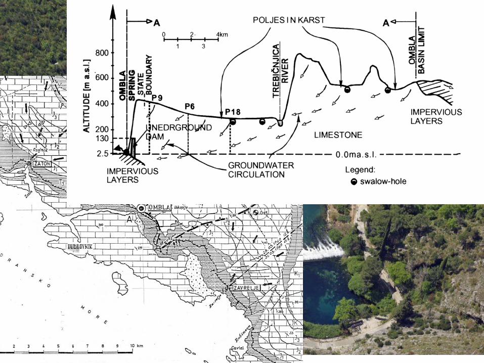
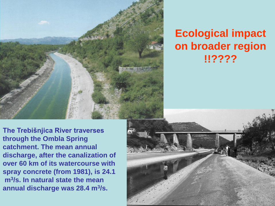
The Trebišnjica River traverses
through the Ombla Spring
catchment. The mean annual
discharge, after the canalization of
over 60 km of its watercourse with
spray concrete (from 1981), is 24.1
m3/s. In natural state the mean
annual discharge was 28.4 m3/s.
Ecological impact
on broader region
!!????

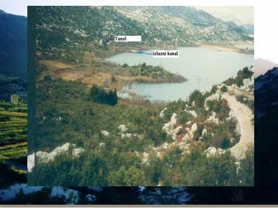
The Lika and Gacka Rivers (Dinaric karst of Croatia)
are typical sinking streamflows : At the same time the
Lika is losing river.
Vrulja

FLOOD IN KARST POLJE
Floods are one of the most dramatic interactions
between human beings and the environment.
People look at floods as a catastrophe but in
reality floods are integral part of nature, playing a
critical role in ecosystem function. At the same
time flooding brings many benefits particularly for
ecological variability and soil fertility. Flooding
promotes exchange of materials and organisms
between habitats and plays a key role in
determining the level of biological productivity and
diversity. Those processes are especially
important for karst environment.

Poljes are regularly flooded in the cold and wet
periods of the year. Because of this they can be
treated as wetlands. Flooding of the poljes in the
Dinaric karst in natural conditions lasts on average
from 3 to 7 months per year, mostly between
October and April, but there are cases when
flooding can even persist for 10 months. With the
objective of flood prevention in poljes, attempts
have been made to increase the capacity of ponors.
Such attempts have usually failed because the
capacity of ponors depends on the conduit system
to which they drain, and on the groundwater level.
The most effective measure to prevent the flooding
or to reduce duration of floods is the construction
of a tunnel. Ecological consequences ???

Tunnels for karst polje flood control:
An example of the Konavosko Polje

Catastrophic flood
on the Upper Dobra River 29 June 1999
Qmax = 254 m3/s
Maximum swallow capacity of the Đula Sink ≈ 80 m3/s.
80 m3/s << 254 m3/s
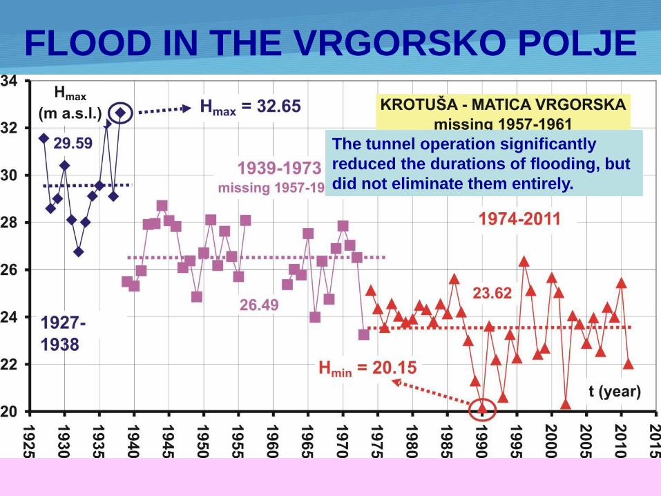
FLOOD IN THE VRGORSKO POLJE
The tunnel operation significantly
reduced the durations of flooding, but
did not eliminate them entirely.
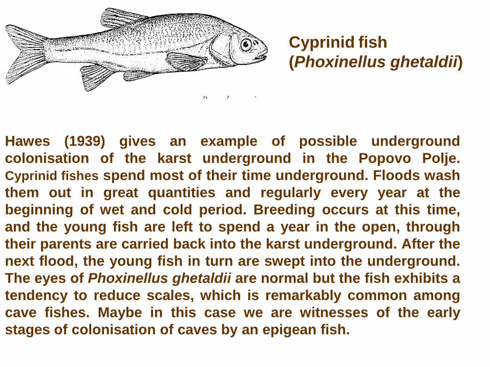
Cyprinid fish
(Phoxinellus ghetaldii)
Hawes (1939) gives an example of possible underground
colonisation of the karst underground in the Popovo Polje.
Cyprinid fishes spend most of their time underground. Floods wash
them out in great quantities and regularly every year at the
beginning of wet and cold period. Breeding occurs at this time,
and the young fish are left to spend a year in the open, through
their parents are carried back into the karst underground. After the
next flood, the young fish in turn are swept into the underground.
The eyes of Phoxinellus ghetaldii are normal but the fish exhibits a
tendency to reduce scales, which is remarkably common among
cave fishes. Maybe in this case we are witnesses of the early
stages of colonisation of caves by an epigean fish.
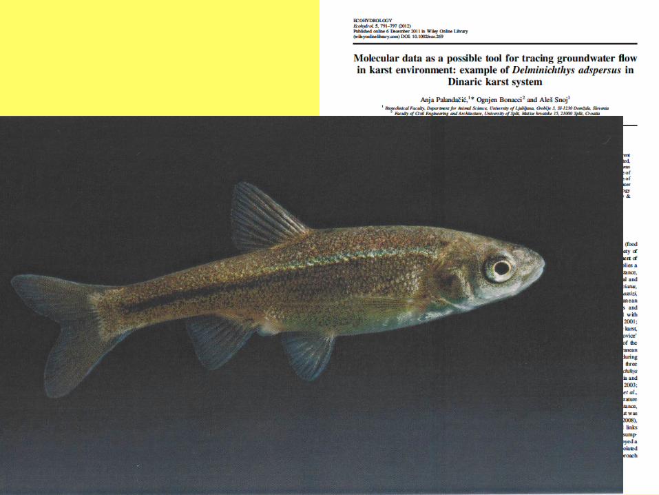
Because of extreme groundwater oscillations in karst, different hydrological connections are active depending on the groundwater level. The methodology of water tracing was developed especially to determine water interconnections in karst. In addition to tracing with salt, dye or temperature, the use of rich endemic fauna, their dispersion and population structure is lately considered. In this paper, population structure of the endemic fish species is used to confirm hydrological data as well as suggest new underground water connections in part of central Dinaric karst.

Role of dry stonewalls
The influence of drystone walls on ecological and geomorphological
processes is important. Terracing is very effective measure against
erosion. Stonewalls are of fundamental importance as a habitat for a
very diverse Mediterranean flora and fauna.
Changes of the biotic and
abiotic factors above the
ground lead to changes
down through the massive
stone clearing to deep
karstic aquatic and
terrestrial habitats. Massive
stone clearing means
entirely disappearance of
stonewalls. This process
could be very dangerous
from ecological and
hydrogeological point of
view.
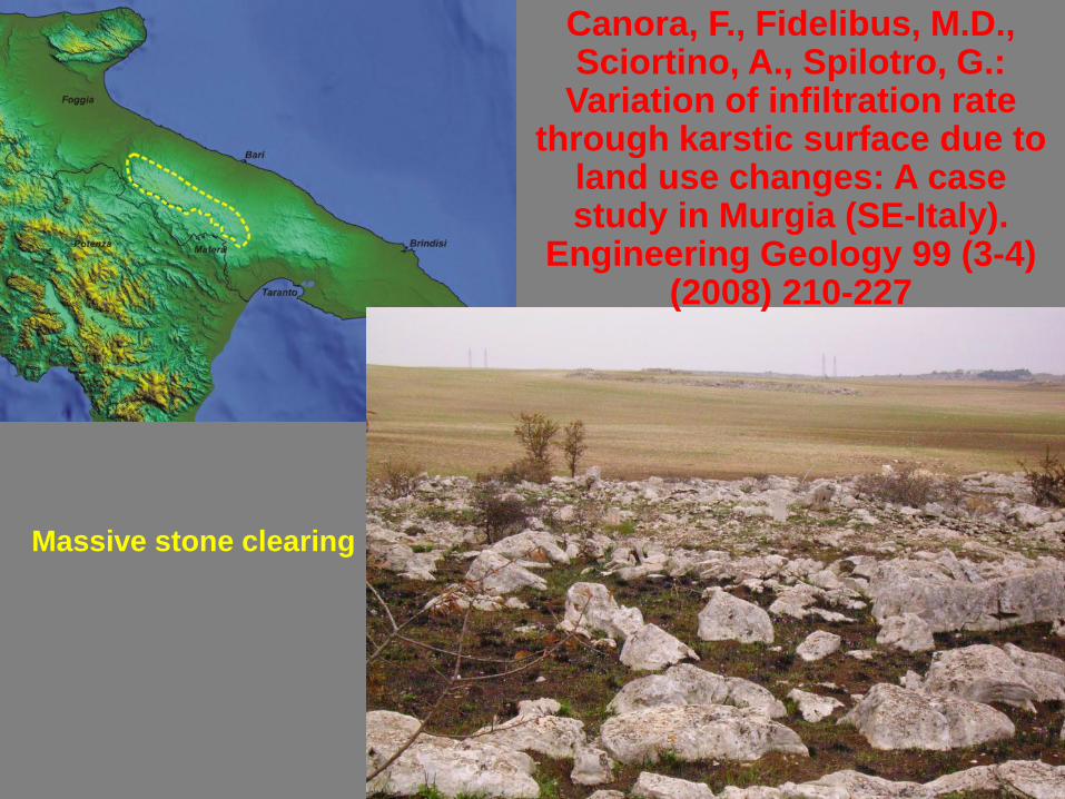
Canora, F., Fidelibus, M.D., Sciortino, A., Spilotro, G.:
Variation of infiltration rate through karstic surface due to
land use changes: A case study in Murgia (SE-Italy).
Engineering Geology 99 (3-4) (2008) 210-227
Massive stone clearing

The above scenario represents a worrying example of man-made evolution of the karst surface’s textural features. Current studies indicate that the agricultural activities in the Murgia have important consequences on groundwater quality. Direct observation of the stone cleared surfaces evidences a net loss of the fine soil component, so farmers are obliged to add new soil. A great part of the lost soil finally reaches the sea during the frequent floods. The soil loss is the closest precursor of the desertification of the concerned areas.
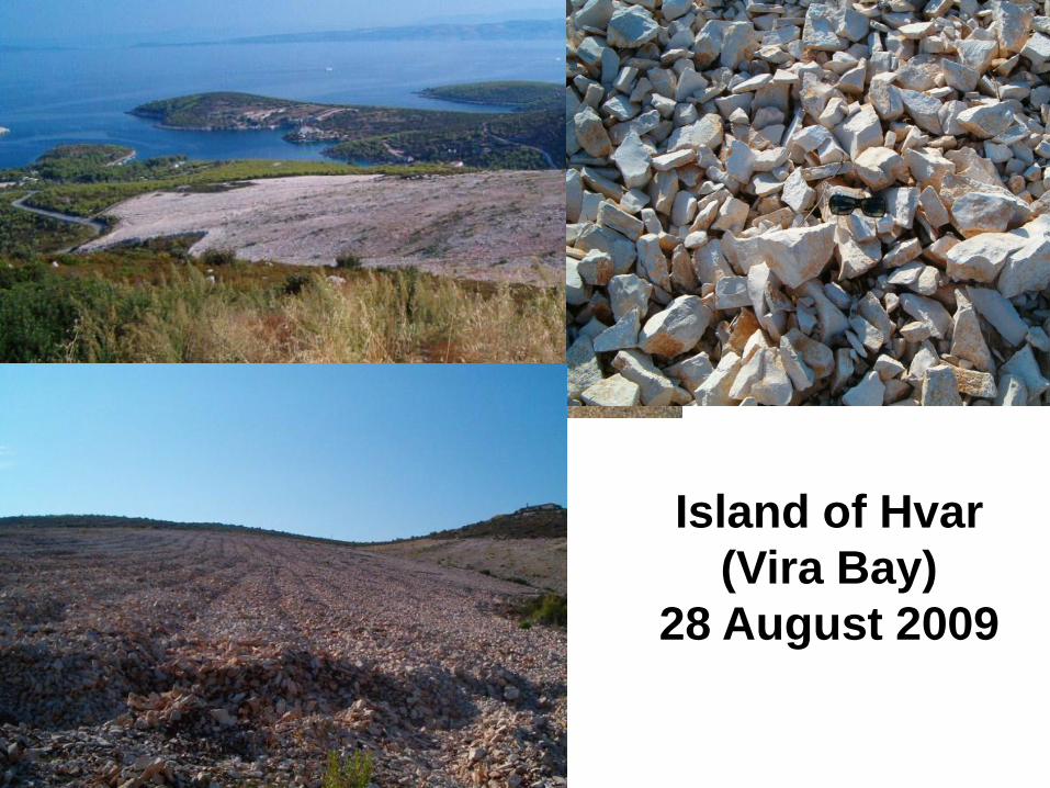
Island of Hvar
(Vira Bay)
28 August 2009

Thank you for
your kind
attention!
San Joaquin valley (California –USA)
1925-1977 SUBSIDENCE 9 m


![Morphogenesis Of Karst Poljes On Vis Island, Croatia...Morphogenesis of karst poljes on Vis Island, Croatia 0RUIRJHQH]DNUãNLKSROMDQDRWRNX9LVX +UYDWVND Kristina KRKLEC 1 *, Sanja /2=,û](https://img.pdfslide.us/doc/110x75/5e451e32eca5713a1816ffbe/morphogenesis-of-karst-poljes-on-vis-island-croatia-morphogenesis-of-karst.jpg)