Embed Size (px)
Citation preview

WORLD METEOROLOGICAL ORGANIZATION___________________________________________
RA IV HURRICANE COMMITTEE
THIRTY-EIGHTH SESSION
SAN JUAN, PUERTO RICO, USA
23 TO 26 APRIL 2016
RA IV/HC-38/Doc.3.2(1)(14.II1.2016)________
ITEM 3.2
Original: ENGLISH
REVIEW OF THE PAST HURRICANE SEASON
Reports of hurricanes, tropical storms, tropical disturbances and related flooding during 2015
Report from the United States of America
(Submitted by the USA)
RA IV/HC-38/Doc. 3.2(1), p. 2
Tropical Storms and Hurricanes that impacted the United States in 2015.
Only Tropical Storm Ana and Tropical Storm Bill made landfall in the United States. Moisture from several tropical cyclones in the eastern North Pacific spread northward causing locally heavy rainfall over portions of the southwestern United States. Most of the rain impact was associated with moisture from Hurricane Linda.
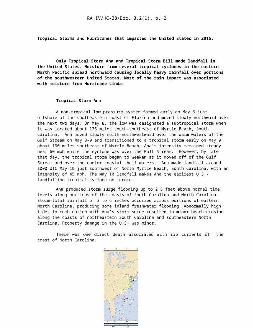
Tropical Storm Ana
A non-tropical low pressure system formed early on May 6 just offshore of the southeastern coast of Florida and moved slowly northward over the next two days. On May 8, the low was designated a subtropical storm when it was located about 175 miles south-southeast of Myrtle Beach, South Carolina. Ana moved slowly north-northwestward over the warm waters of the Gulf Stream on May 8-9 and transitioned to a tropical storm early on May 9 about 130 miles southeast of Myrtle Beach. Ana’s intensity remained steady near 60 mph while the cyclone was over the Gulf Stream. However, by late that day, the tropical storm began to weaken as it moved off of the Gulf Stream and over the cooler coastal shelf waters. Ana made landfall around 1000 UTC May 10 just southwest of North Myrtle Beach, South Carolina, with an intensity of 45 mph. The May 10 landfall makes Ana the earliest U.S.-landfalling tropical cyclone on record.
Ana produced storm surge flooding up to 2.5 feet above normal tide levels along portions of the coasts of South Carolina and North Carolina. Storm-total rainfall of 3 to 6 inches occurred across portions of eastern North Carolina, producing some inland freshwater flooding. Abnormally high tides in combination with Ana’s storm surge resulted in minor beach erosion along the coasts of northeastern South Carolina and southeastern North Carolina. Property damage in the U.S. was minor.
There was one direct death associated with rip currents off the coast of North Carolina.
Tropical Storm Bill

RA IV/HC-38/Doc. 3.2(1), p. 3
Bill formed on June 16 while centered about 200 miles east-southeast of Corpus Christi, Texas and moved northwestward toward the Texas coast. Bill made landfall on Matagorda Island at 1645 UTC June 16 with maximum winds of 60 mph. Later that evening, Bill turned northward and accelerated inland over eastern Texas, weakening to a tropical depression early on June 17 when centered about 35 miles east of Austin, Texas. The depression continued northward for the next two days, and became a remnant low on June 18 while located about 75 miles south-southeast of Tulsa, Oklahoma. Bill’s remnant low moved east-northeastward for the next few days, producing heavy rain, flooding, and tornadoes across southern Missouri, northern Arkansas, and portions of the Ohio River Valley. The low dissipated on June 21 over the mountainous terrain of West Virginia.
Bill produced a storm surge of 3.5 feet just east of its landfall point. Combined with the normal tide, Bill’s surge produced inundation of 1 to 3 feet above ground level for parts of the upper Texas and southwestern Louisiana coasts.
Heavy rains from Bill also fell from the central Texas coast northeastward across eastern Texas, western Louisiana, and southern and eastern Oklahoma. Many locations reported storm-total amounts in excess of 10 inches with the highest rainfall report being 13.78 inches in Ganado, Texas. The heavy rainfall caused flash floods and flooding of major rivers across portions of Texas and Oklahoma. The Red River at Interstate 35 along the Texas/Oklahoma border reached a record crest of 42.05 feet,17 feet above flood stage. Farther north, the Washita River near Dickson, Oklahoma, reached a record crest of 48.70 feet, which was more than 21 feet above flood stage. Flash flooding was reported in the Austin and San Antonio metro areas. Property damage in the U.S. was minor.
Bill caused two direct deaths as a result of heavy rain and flooding in Oklahoma during its tropical depression stage. In addition, Bill’s precursor disturbance produced heavy rains, flooding, and landslides over portions of Central America and the Yucatan Peninsula of Mexico. In Honduras, two people died in floodwaters near Tegucigalpa, while two other people were reported missing. More than 500 people were affected by floods and landslides in Honduras. Two people died in landslides in Guatemala, with 516,000 people having been affected by flooding and landslides in that country.
Tropical Storm Erika
Erika moved over the northeastern Caribbean Sea August 28, passing south of the U.S. Virgin Islands and Puerto Rico. Later that day, Hurricane Hunter aircraft

RA IV/HC-38/Doc. 3.2(1), p. 4
observations revealed that Erika no longer had a well-defined center of circulation, and the tropical cyclone dissipated just south of the eastern tip of Hispaniola. However, damage estimated near $17.4 million occurred in Puerto Rico, mainly due to losses of plantains, bananas, and coffee.
Hurricane Joaquin
Joaquin did not make landfall in the United States. However, it is directly responsible for 34 deaths in the waters off the Bahamas and Haiti. Almost all of the deaths occurred when the U.S.-flagged cargo ship El Faro was lost at sea near the Bahamas while Joaquin was moving through the area.
Hurricane Linda
Moisture partially originating from Linda spread northward, causing locally heavy rainfall over portions of the southwestern United States. On 15 September, a strong mid- to upper-level trough and the remnants of Linda moved eastward into southern California producing 2.39 inches of rain in Los Angeles on that day. This was the second-wettest September day since records began in that city in 1877. A rainfall total of 1.15 inches was observed in San Diego that same day, which was also that city’s second-wettest September day on record.
Linda and its remnants caused no casualties or damage in the United States. Media reports, however, indicate that 7 hikers died in a narrow canyon in Utah’s Zion National Park when it filled with rushing water during the flash flood. That same day,12 other people, including nine children, died in Hildale, Utah, when two vehicles were swept away in flash flooding. A 6-year old child in one of the vehicles remains missing and is presumed to have perished. The 20 fatalities that occurred in Utah that day makes it the deadliest flood event in the state’s history. These are not considered direct deaths caused by the tropical cyclone.


![Gregoriano - Cantoepregocantoeprego.it/serv/gregoriano.pdf · 2114.11 Anima Christi pag. 3 - [ag. 27/05/11] Ánima Christi, sanctífica me. Corpus Christi, salva me. Sanguis Christi,](https://img.pdfslide.us/doc/110x75/5adb4ff47f8b9a6d7e8dcdb5/gregoriano-ca-anima-christi-pag-3-ag-270511-nima-christi-sanctca-me.jpg)