Embed Size (px)
Citation preview

EAST METRO RAILCAPACITY STUDY
OCTOBER 2012
PREPARED FOR: PREPARED BY:IN PARTNERSHIP WITH:


East Metro Rail Capacity Study
Prepared for Ramsey County Regional Railroad Authority
in partnership with
Red Rock Corridor Commission
By the Study Team of:TranSystems Corporation
Kimley-Horn and Associates, Inc.Rani Engineering
The 106 Group Ltd.American Engineering Testing, Inc.
LTK Engineering ServicesDavid Simpson Consultants
HAD-Rail Consulting ServicesDavid Evans and Associates, Inc.

i
Table of Contents
Definitions
Abbreviations
EXECUTIVE SUMMARY ............................................................................................................................. ES-1
1.0 Study Background and Purpose .................................................................................................... 1
1.1 Study Area .................................................................................................................................... 3
1.2 Project Partners ............................................................................................................................ 3
1.3 Scope of Study .............................................................................................................................. 6
2.0 Study Process ................................................................................................................................ 7
2.1 Project Development Process ....................................................................................................... 7
2.2 Study Partner Roles ...................................................................................................................... 7
2.3 Study Partner Involvement Process ............................................................................................. 9
Project Management Team Meetings and Stakeholder Workshops/Meetings ........................... 9
Freight Railroads ......................................................................................................................... 10
Public Open Houses and Neighborhood Meetings ..................................................................... 11
3.0 Other Studies and Projects Relevant to the Study Area ............................................................. 12
3.1 Past Studies ................................................................................................................................. 12
3.2 Current Projects .......................................................................................................................... 16
4.0 Project Understanding ................................................................................................................ 20
4.1 Study Outcomes ......................................................................................................................... 20
Maintain On-Time Performance and Hold Freights Whole ........................................................ 21
Allow for Freight and Passenger Rail Growth ............................................................................. 21
Conceptual Engineering Completed on Agreed-To Capacity Improvements ............................. 22
4.2 Project-Specific Agreements ...................................................................................................... 22
4.3 General Rail Operations .............................................................................................................. 24
Facilities and Track Ownership ................................................................................................... 24

ii
Through Movements .................................................................................................................. 27
Yard Operations and Interchange ............................................................................................... 28
Train Volumes ............................................................................................................................. 32
4.4 Physical Constraints .................................................................................................................... 37
Drainage/Stormwater ................................................................................................................. 37
Cultural Resources ...................................................................................................................... 41
Geotechnical ............................................................................................................................... 44
Environmental ............................................................................................................................ 47
Right-of-Way ............................................................................................................................... 49
5.0 Study Requirements and Assumptions ....................................................................................... 50
5.1 Study Requirements ................................................................................................................... 50
Accommodate Freight and Passenger Trains ............................................................................. 50
Mitigate Excessive Mainline Occupancy ..................................................................................... 50
Provide Multiple Rerouting Opportunities ................................................................................. 50
5.2 Study Assumptions ..................................................................................................................... 50
General Operating Assumptions................................................................................................. 50
General Routing Assumptions .................................................................................................... 51
Signaling Assumptions ................................................................................................................ 51
Freight Traffic Volumes Existing and Growth Over Time ........................................................... 52
Passenger Volumes - Existing and Growth over Time ................................................................ 53
6.0 Concept Development ................................................................................................................ 53
6.1 Infrastructure Options/Potential Improvements ....................................................................... 53
Scheduling/Dispatching .............................................................................................................. 53
Train Routing .............................................................................................................................. 54
Lower Cost Capital Improvements ............................................................................................. 55
Higher Cost Capital Improvements ............................................................................................. 55
6.2 Options Considered for Further Study ....................................................................................... 55
OPTION 1.5: Northern Upgrades ................................................................................................ 55
iii
OPTION 2.0 River Route along BNSF Mainline / OPTION 3.0 Highway 61 Route along CP
Mainline ...................................................................................................................................... 64
OPTION 4.0/OPTION 5.0 St Croix – Hastings Improvements ...................................................... 72
6.3 Operations Analysis .................................................................................................................... 79
Model Input ................................................................................................................................ 79
Model Layout and Analysis Scenarios ........................................................................................ 81
Network Configurations and Performance Measures ................................................................ 84
Analysis Results and Stakeholder Input ...................................................................................... 85
Follow-Up Analyses..................................................................................................................... 88
Results Summary ........................................................................................................................ 89
Growth Analysis .......................................................................................................................... 95
6.4 Role of Stakeholders in Concept Development .......................................................................... 99
7.0 Concept Recommendations ....................................................................................................... 99
7.1 Conceptual Engineering .............................................................................................................. 99
7.2 Cost Estimates .......................................................................................................................... 103
7.3 Recommendations .................................................................................................................... 105
7.4 Ranking of Improvements ........................................................................................................ 107
7.5 Phasing of Improvements ......................................................................................................... 107
8.0 Next Steps ................................................................................................................................. 108
8.1 Plan Implementation ................................................................................................................ 109
8.2 Environmental Review Process ................................................................................................. 109
8.3 Preliminary Engineering............................................................................................................ 114
8.4 Final Engineering ...................................................................................................................... 114
8.5 Construction ............................................................................................................................. 115
9.0 Conclusion ................................................................................................................................ 115

iv
EXHIBITS
Exhibit 1 Average Train Volumes by Carrier
Exhibit 2 Permit Authority
Exhibit 3 Watershed Criteria
Exhibit 4 General Environmental Constraints Noted Within the Project Area
Exhibit 5 Baseline Data Train Count, Trains per Week
Exhibit 6 36 Percent Freight Growth Summary
Exhibit 7 Model Results, Passenger Traffic = Empire Builder Only
Exhibit 8 Model Results, Passenger Traffic = Empire Builder, Red Rock, Amtrak, and HrSR Intercity
Exhibit 9 Comparison of Average Freight Train Speeds for Proposed Options
Exhibit 10 BNSF Average Train Speed and Average Congestion
Exhibit 11 CP Average Train Speed and Average Congestion
Exhibit 12 UP Average Train Speed and Average Congestion
Exhibit 13 Congestion Will Rise with Freight Volume Growth
Exhibit 14 Freight Train Speed Suffers with Added Volume
Exhibit 15 Cost Estimates (2011 Dollars in Millions)
Exhibit 16 Option Summary Matrix
Exhibit 17 Study Process and Next Steps
FIGURES
Figure 1 Existing Freight Routes Through East Metro Study Area
Figure 2 Primary Study Area and Critical Areas
Figure 3 Primary and Secondary Study Areas
Figure 4 Red Rock Corridor Commuter Route
Figure 5 Current Projects
Figure 6 Subdivisions in the Study Area
Figure 7 East Metro Rail Yards
Figure 8 Train Counts
Figure 9 Drainage/Water Resources
Figure 10 Known Historic and Archaeological Resources
Figure 11 Other Environmental Issues
Figure 12 Overall Option 1.5 – Westminster to Dunn Yard
Figure 13 Proposed Lower Afton Station Site
Figure 14 Option 1.5 – CP Auto Facility Siding
Figure 15 Option 1.5 – UP Main

v
Figure 16 Proposed Newport Station Site
Figure 17 Option 2 – Newport to Cottage Grove
Figure 18 Option 2 – St. Croix to Hastings
Figure 19 Proposed Red Rock Corridor Cottage Grove/Langdon Village Site
Figure 20 Option 3 – Newport to Cottage Grove
Figure 21 Option 4 – St. Croix to Hastings
Figure 22 Proposed Hastings Station Site
Figure 23 Option 4 – BNSF Siding
Figure 24 Options 5 and 5A – St. Croix to Hastings
Figure 25 Model Baseline Layout
Figure 26 Concept Engineering Locations
Figure 27 Overall Potential Environmental Concerns
APPENDICES
Appendix A Tech Memo 1, Summary of Previously Completed Work, Current Projects, and Project
Constraints
Appendix B Water Resources Mapping
Appendix C Cultural Resources Literature Review Reports
Appendix D East Metro Operations Modeling and Analysis Final Report
Appendix E Engineering Plan Set for Location 1, Option 5A
Appendix F Engineering Plan Set for Location 2, Option 5
Appendix G Engineering Plan Set for Location 3, Option 5
Appendix H Engineering Plan Set for Location 4
Appendix I Engineering Plan Set for Location 4A
Appendix J Engineering Plan Set for Location 5
Appendix K Engineering Plan Set for Location 6
Appendix L Engineering Plan Set for Location 7
Appendix M Signal Engineering Plan Set – BNSF
Appendix N Signal Engineering Plan Set – CP
Appendix O Rail Design Memorandum
Appendix P Detailed Cost Estimates

Definitions-1
Definitions
100-year floodplain – Land area adjacent to a body of water subject to a one percent chance of flooding
in any given year.
Block – A grouping of railcars on a train, all having a common destination.
Block swap –Adjustment of a train’s consist by dropping off and picking up blocks.
Class I railroad - Until 1955 a railroad with annual gross operating revenue of $1 million or more. In
1955 the threshold became $3 million. By 1992, it had risen to $250 million. Currently at $256.4 million.
Class III railroad - A railroad with average annual gross revenue under $20.5 million.
Commuter rail – Railway for urban passenger train service consisting of short distance travel between a
central city and adjacent suburbs. Typically characterized by multi-trip tickets, station-to-station fares,
and morning and evening peak period “commuter” operations.
Consist – A train’s make-up; a listing of engines and railcars comprising a train.
Crossover - Two turnouts with track between, connecting two nearby and usually parallel tracks.
Departure track - Where cuts of cars are assembled to form outbound trains.
Directional-running – Reference to trains operating in a single direction. The practice of operating
trains in only one direction on a track. With paired tracks or alternate routes between two points, trains
are operated in one direction on the first track/route and the opposite direction on the other
track/route, effectively avoiding the meeting of trains.
Dispatch –To direct train movements according to a schedule, by priority protocol and/or based on track
availability.
Flyover - A bridge that carries one roadway or railway aerially over another.
Hump yard- A switching yard on an incline where, after movements by the engine, the cars are shunted
by gravitational pull to their destination in a yard.
Industrial lead - A track that connects tracks at an industry to the rail network.
Interchange point- The location where railcars are transferred from one railroad to another.

Definitions-2
Interlocking- An arrangement of signals and switches 'interlocked' in such a way that train movements
must succeed each other in a predetermined order so that a clear indication cannot be given
simultaneously on conflicting routes. They are found at a crossing of two railroads, a moveable bridge,
junction, or entering or leaving a terminal or yard.
Intermodal trains –Trains that transport freight in containers or trailers in conjunction with other modes
of transportation (e.g., ship and truck) to deliver product from origin to destination, without any
handling of the freight itself when changing modes.
Joint-operation - Operation of two railroads as one unit.
Junction - A point at which two lines or separate routes converge or diverge from each other.
Lead track - An extended track connecting a yard with main track.
Locomotive – Railway vehicle that provides the motive power to a train.
Long-haul – A long-distance movement in reference to the transport of freight or passengers.
Mainline - That part of a railroad exclusive of switch tracks, branches, yards and terminals.
Manifest/manifest trains – Freight train made up of mixed freight and car types; a description of the
contents of a shipment.
Passenger rail - Means of conveyance of passengers by way of wheeled vehicles running on rail tracks.
Rail carrier - An entity providing rail transportation for compensation.
Rail Yard - A complex of tracks and other infrastructure in which locomotives and rolling stock are
stored and rearranged.
Railcar - A railway vehicle without motive power.
Receiving yard - The destination for arriving trains carrying cars to be sorted or classified.
Routing –The designated course or direction a shipment shall move.
Shunt – To move rolling railroad cars from one track to another.
Sidings – A short stretch of railroad track that connects with the main track.

Definitions-3
Simulation modeling – A computer modeling process to mimic the movement of freight and/or
passenger rail through a railroad network assuming various speeds, available infrastructure, dispatch
protocols, etc.
Subdivision - A portion of the railroad designated by timetable.
Switch - A connection between two lines of track to permit cars or trains to pass from one track to the
other track; to move cars from one place to another within a defined territory such as an industry, a
yard, or a terminal.
Switching yard - A rail yard where railcars are switched and trains assembled.
Tail track - Track that is available for storage and turn-around of a train.
Terminal/rail terminal - Facilities provided by a railroad at a terminus or at any intermediate point on its
line for the handling of passengers or freight, and for the breaking up, making up, forwarding and
servicing trains, and interchanging with other carriers.
Throughput – The number of trains or railcars or the amount of material or items passing through a rail
system.
Track occupancy – The proportion of track occupied or in use.
Transfer/transfer runs - A train that moves cars from one freight yard to another within a large terminal
area.
Turnout - A switch that enables a train to be guided from one track to another
Unit trains - Trains from one shipper/origination to one consignee/destination without any switching or
classification en route, often carrying a single bulk commodity, such as coal or grain.
Wye - A track in the form of a "Y" which leads from a main line and is used in lieu of a turntable for
turning engines, cars and trains around.

Abbreviations-1
Abbreviations
BNSF Burlington Northern Santa Fe Railway Company
CP Canadian Pacific Railway
FEMA Federal Emergency Management Agency
MnDNR Minnesota Department of Natural Resources
MnDOT Minnesota Department of Transportation
MNNR Minnesota Commercial Railway
NEPA National Environmental Policy Act
NWI National Wetlands Inventory
PMT Project Management Team
RCRRA Ramsey County Regional Railroad Authority
RRCC Red Rock Corridor Commission
TC&W Twin Cities & Western Railroad Company
UP Union Pacific Railroad Company

ES-1
EXECUTIVE SUMMARY
Introduction “America’s freight railroad system is the envy of the world.”1 Our nation’s rail network can transport
freight more economically, efficiently, and safely than any other country. Like any treasured asset, our
network of railroads must be protected and maintained; however, the Department of Transportation
estimates that many are already exceeding capacity and are congested. It estimates that significant
additional investment will be needed, as capacity will have to rise by nearly 90 percent to meet forecast
demand by 2035. Clearly, we must continue to reinvest in our nations rail network to keep our global
advantage.
Establishment of railroads in the St. Paul area of the Twin Cities was constrained to specific corridors
that allowed for acceptable grades to traverse from along the Mississippi River to the top of the bluffs.
The primary location for this transition happens just east of downtown St. Paul or the “East Metro” area.
This significant crossroads for United States freight handles 10,000 cars per day, or five percent of the
nation’s freight volume. Freight rail lines are congested through this area today, and capacity
improvements are limited by physical features. Forecasted growth in freight traffic will result in a
deterioration of service reliability and speed. The planned introduction of commuter, higher speed, and
additional intercity passenger rail will further strain the existing rail capacity in this area, requiring
additional operational and physical improvements to the existing rail facilities in the immediate area and
beyond.
Ramsey County Regional Railroad Authority (RCRRA) in partnership with the Red Rock Corridor
Commission (RRCC), commissioned the East Metro Rail Capacity Study (Study) to identify needs,
constraints, and potential solutions related to developing a regional multimodal transit hub at Union
Depot in downtown St. Paul, Minnesota. The purpose of the Study is to:
Understand the limitations of the rail system, considering existing conditions and constraints plus
projected growth in both freight and passenger rail
Identify potential options for addressing these limitations, including physical (capacity)
improvements, as well as operational changes
Develop conceptual designs for physical improvements and planning-level cost estimates
The outcomes of this Study must be acceptable to the freight railroads which own and manage the
rights-of-way, as well as other key stakeholders. As a result, the improvement scenarios have been
developed with the goals of maintaining on-time performance, keeping freights “whole,” (maintaining
or slightly improving freight operations), and allowing for future freight and passenger rail growth.
1 National Academy of Engineering, The Freight Railroad Renaissance, Summer 2008.

ES-2
Study Area The primary Study Area is centered around Union Depot in St. Paul. A larger, secondary Study Area
extending to Hastings was also considered in order to capture additional potential improvements that
could increase freight rail capacity within the primary Study Area. These areas are shown in Figure ES-1.
Figure ES-1 Project Study Areas

ES-3
Project Partners Staff from a large number of public and private agencies and organizations contributed to the Study
through participation on the Project Management Team (PMT), agency workshops, and stakeholder
meetings. These included:
Private
Amtrak BNSF Railway (BNSF) Canadian Pacific Railway (CP) Minnesota Commercial Railroad (MNNR) Twin Cities and Western Railroad (TC&W) Union Pacific Railroad (UP) Federal Agencies Federal Railroad Administration (FRA) Federal Transit Administration (FTA) State/Regional Agencies Metropolitan Council Minnesota Department of Transportation Organizations Capitol River Council Friends of the Mississippi River Lower Phalen Creek Project
Counties Dakota County Regional Railroad Authority Hennepin County Regional Railroad Authority Ramsey County Public Works Ramsey County Regional Railroad Authority (RCRRA) Washington County Regional Railroad Authority Red Rock Corridor Commission Cities City of Cottage Grove City of Hastings City of Maplewood City of Newport City of St. Paul St. Paul Department of Parks and Recreation City of St. Paul Park
ES-4
Scope of Study The Study addresses capacity improvements needed to implement commuter and higher speed
passenger rail. It also addresses how impacts to freight railroads could be mitigated, and how capacity
improvements could be phased so that they are implemented only as needed. The Study does not
include National Environmental Policy Act (NEPA) documentation; however, it does include high-level
environmental and cultural resource screening to identify sensitive and important resources for
consideration during concept development and subsequent project development steps.
The first step in the Study process was to gain an understanding of the existing limitations to the system
for freight, both current and projected, and then layer on the additional scenarios of new higher speed
intercity passenger rail and commuter rail service into Union Depot using a detailed simulation model.
Once the system’s limitations were understood, options for additional capacity were investigated.
Based on all of this information, conceptual designs and planning-level cost estimates were developed
for recommended infrastructure improvements, and required short- and long-term capacity
improvements were identified based on priority and estimated cost.
Study Process This Study is the first step in a multi-phase process. It affords the opportunity to develop a baseline and
a “master plan” for future improvements that will address capacity and fluidity needs as freight and
passenger rail are added in the future. Great care has been taken to involve stakeholder railroads and
other partners to understand the current system operations and operational constraints, as well as
current physical constraints.
Beyond this Study, it is the intent that individual concept recommendations or “projects” will move
forward into preliminary engineering and will be subject to more comprehensive environmental review
under federal and state requirements. A Memorandum of Understanding is being developed to
document that stakeholder railroads have agreed these recommendations are needed to accommodate
the freight and passenger growth that is expected. Subject to funding and need, these projects will
move forward into final design and construction. Therefore, this Study provides the foundation for
future rail improvements in the East Metro Study Area.
Stakeholder Involvement
RCRRA engaged various stakeholders through a series of Project Management Team (PMT) and agency
stakeholder meetings, as well as separate individual meetings and conference calls with rail
stakeholders. Key stakeholders involved in the Study process are described below.

ES-5
The Red Rock Corridor Commission (RRCC) has a vested interest in future improvements to the East
Metro area since Red Rock Corridor is an identified future transit corridor connecting Hastings to St. Paul
and Minneapolis. The RRCC funded part of this Study and was represented on the PMT.
As owners and operators of the rail system in the East Metro area, freight railroads were key partners in
the study development process. The role of the railroads was to provide direct input into operating
parameters and simulation model input/output, as well as review and approval of proposed concepts.
All Class I and Class III railroads in the Study Area, including BNSF Railway (BNSF), Canadian Pacific
Railway (CP), Union Pacific Railroad (UP), Minnesota Commercial Railroad (MNNR), and Twin Cities and
Western Railroad (TC&W), had representation on the PMT.
Public agencies such as Minnesota Department of Transportation (MnDOT), Metropolitan Council,
Amtrak, the Federal Railroad Administration (FRA), and cities and counties in the project area were also
engaged. The primary role of these public entities was to share information about other projects in the
area, to gain an understanding of the capacity improvements proposed and their impact on the
city/county, and to provide input on the impacts.
The general public also played a role in the development of this Study through public meetings and
neighborhood meetings. The general public will play a larger role in future phases of project
implementation, including NEPA implementation and design of specific improvements.
Existing and Future Conditions Prior to creating concepts, the Study team developed a thorough understanding of existing and
potential future conditions. This included a review of past studies and active projects, and identification
of minimum performance needs, operational needs, and physical constraints.
Other Studies and Projects Nearly a dozen rail-related studies relevant to the Study Area have been conducted in recent years,
including many focused on Union Depot in downtown St. Paul. These studies document the considerable
interest in enhancing passenger rail capacity in the East Metro area, underscore the need for
coordination among the various projects, and highlight the desire to address the inter-related issues of
constrained rail capacity and limited right-of-way. Several infrastructure projects underway in the Study
Area suggest both the need for coordination among projects and the potential for mutually enhanced
outcomes as a result. As relevant, the Study team incorporated elements of these projects into the
Study with respect to both operations modeling and physical footprint or right-of-way needs.

ES-6
Project Understanding
Study Outcomes
The following issues were identified early in the Study as critical to maintaining freight operations within
the Study Area as both passenger and freight volumes increase in the future:
Maintain on-time performance and hold freights whole: Maintain freight operations with
minimal disruptions while also maintaining safety and on-time performance.
Allow for freight and passenger rail growth: Preserve current freight capacity, and ensure that
any new alignments or capital improvements constructed for implementation of passenger
service also accommodate the future freight growth for the owner of the right-of-way.
Anticipate Future Rail Carrier Agreements: Development of any new passenger facilities will
necessitate formal, project-specific agreements among sponsoring agencies and rail carriers.
Therefore, it is important that each of these entities be involved with and feel comfortable with
the outcomes of this Study.
Operational Issues
The following types of operational issues were taken into account in the understanding of existing and
future conditions and the development of potential improvements: through train movements, yard
operations, service to local rail clients, and changes in train volumes. Specific ownership of track and
facilities, while acknowledged, was not embedded as a constraint in the operational assessments.
Facilities and Track Ownership
The three Class I railroads operating within the Study Area actively share trackage and coordinate
schedules in order to optimize movement of freight and passengers. The related issues of track
ownership, ownership and uses of the various rail yards, dispatch locations and logistics were
incorporated into the analysis and the development of potential improvements.
Through Movements
Each of the three Class I carriers operates both through movements and originating and terminating
trains within the Study Area, as described below.
BNSF Railway (BNSF) operates the majority of through traffic, as many as 40 to 60 trains per
day. Intermodal, manifest, auto, and unit trains carrying coal, iron ore, grain, ethanol, and other
commodities make up the mix of traffic handled by BNSF.
Canadian Pacific Railway (CP) originates and terminates as many as 32 trains daily at their St.
Paul Yard. The railroad also operates interchange and transfer jobs out of the north end of the
yard to various locations and handles a number of through trains through the Study Area daily.

ES-7
Union Pacific Railroad (UP) operates three yards within the primary Study Area and two more in
the secondary Study Area, resulting in complex operations. Their terminal presence is known for
extended track occupancy, both on their own lines and those of CP and BNSF. UP originates and
terminates manifest trains and also operates through trains, particularly unit coal trains, via the
Robert Street Lift Bridge over the Mississippi River, where speeds are limited to 10 mph.
Twin Cities and Western Railroad (TC&W) operates to and from the East Metro terminal on a daily
basis, delivering and receiving traffic from the Class I carriers for furtherance to and from local rail
freight clients in southern and western Minnesota.
The Minnesota Commercial Regional Railroad (MNNR) has trackage rights down the Merriam Park
Subdivision, but presently does not exercise these rights except when taking locomotives to CP’s St. Paul
Yard for service. Occasionally, MNNR serves a couple of customers with a small local train it operates
from the BNSF Midway Subdivision to the UP Altoona Subdivision.
In addition to the three Class I freight trains, Amtrak’s Empire Builder has daily passenger service that
connects Chicago with the Pacific Northwest on a route that includes the Twin Cities and will soon be
stopping at Union Depot.
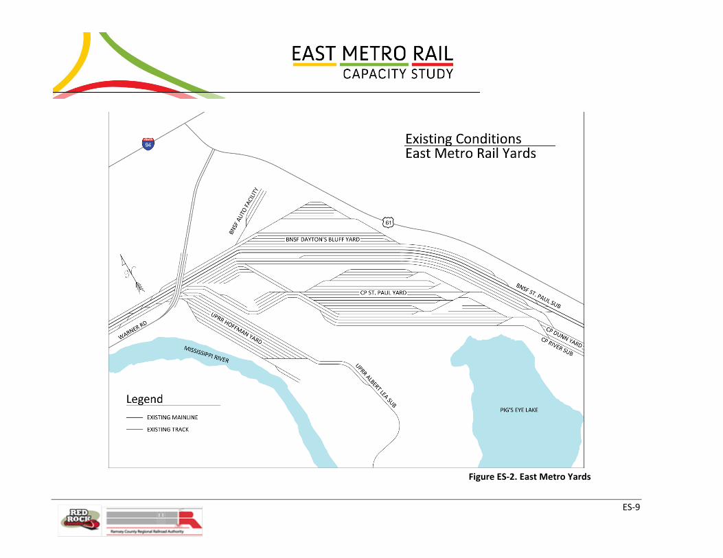
Yard Operations
The Study incorporated a thorough understanding of the three Class I carriers’ expectations for the
freight yards they collectively operate in the primary Study Area, so that any potential improvements
could adequately address yard issues. The yards include BNSF Dayton’s Bluff Yard, CP St. Paul Yard, UP
Hoffman Yard (see Figure ES-2), UP South St. Paul Yard, and UP Western Avenue Yard.
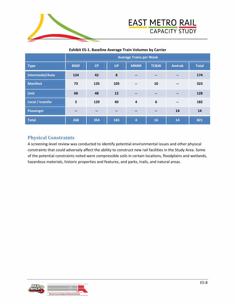
Train Volumes
The Study team considered train volumes for the Class I carriers (freight) and for Amtrak (passenger) in
its identification of needs and potential solutions, taking current train volumes and using growth factors
to forecast potential future conditions, as well.
ES-8
Exhibit ES-1. Baseline Average Train Volumes by Carrier
Average Trains per Week
Type BNSF CP UP MNNR TC&W Amtrak Total
Intermodal/Auto 124 42 8 -- -- -- 174
Manifest 73 135 105 -- 10 -- 323
Unit 68 48 12 -- -- -- 128
Local / transfer 3 129 40 4 6 -- 182
Passenger -- -- -- -- -- 14 14
Total 268 354 165 4 16 14 821
Physical Constraints A screening-level review was conducted to identify potential environmental issues and other physical
constraints that could adversely affect the ability to construct new rail facilities in the Study Area. Some
of the potential constraints noted were compressible soils in certain locations, floodplains and wetlands,
hazardous materials, historic properties and features, and parks, trails, and natural areas.
ES-9
Figure ES-2. East Metro Yards

ES-10
Concept Development
Study Requirements and Assumptions The Class I railroads agreed on three fundamental requirements that the Study and the improvement
concepts under consideration needed to meet:
Concepts under consideration should not only handle current volumes but also accommodate
future freight and passenger rail traffic.
Proposed alternatives must mitigate the problem of excessive mainline occupancy.
Proposed infrastructure improvements must provide multiple routing opportunities, thereby
building in flexibility for accommodating rail traffic and allowing maximum efficiency.
The Study team worked with project stakeholders to develop assumptions to be used in the
development and operational analysis of the improvement concepts. Assumptions were tested and
discussed to ensure they were agreed-upon, supportive of the Study goals, and would provide a sound
foundation upon which to base further actions. Assumptions were developed related to operations,
routing, signaling, and freight and passenger traffic volumes.
Options Considered To understand what improvements would be needed, the Study team developed an understanding and
agreement on anticipated freight and passenger rail growth. Exhibit ES-2 summarizes the baseline and
36 percent growth scenarios. The baseline was established as current infrastructure and train activity,
which was confirmed by the stakeholder railroads. The 36 percent growth factor, which was based on
the individual railroads’ annual growth projections for the next ten years, also gained consensus of the
Class I stakeholder railroads. The freight growth scenario modeled assumed 179 more trains for a total
of 986 freight trains per week, a 22 percent increase over baseline. In addition to the existing 14 weekly
Amtrak trains, new passenger service modeled included 50 Red Rock commuter trains and 84 higher-
speed intercity trains each week.
Exhibit ES-2. Baseline and Growth Freight Volumes
Volume Freight Trains
per Week
Train Count
Growth Over
Baseline
Train-feet per
Week
Volume Growth
Over Baseline
Baseline 807 N/A 4.7 million N/A
36% Growth 986 22% 6.4 million 36%
ES-11
It was important to the Study partners to identify lower cost capital improvements in addition to higher-
cost improvements. As an example, stakeholder railroads agreed to focus on what is best for the
railroad network as a whole instead of only within specific right-of-way. This approach will help to
reduce curves without necessitating significant property acquisition, increasing speeds and capacity.
Upgrading turnouts is another example of a relatively inexpensive improvement that can reap capacity
benefits to the network, along with sidings, additional yard track, and other relatively low-cost physical
modifications or enhancements that could have significant operational benefits.
The Study team developed five packages of capital improvement options (Options 1.5, 2, 3, 4, and 5) and
compared them to future baseline conditions (Option 1). In general, the higher-numbered options build
upon and include the improvements in the lower-numbered options, adding additional improvements
(and resulting capacity and performance enhancements) in a step-wise manner.
Option 1 – Existing Condition: Current infrastructure, network configurations, and current operations
used for comparison against the improvement concepts.
Option 1.5 - Northern Upgrades: Consists of 14 upgrade projects in the northernmost portion of the
Study Area which would accommodate the forecasted growth of freight rail and would allow capacity
for projected passenger service. The improvements also would enable an increase in average terminal
train speed. Improvement projects include new mainline segments, flyover/jump track and “duck
under” tracks, switch upgrades, yard shifts to allow space for additional track, tail track, a siding, and
various other minor improvements.
Option 2 - River Route along BNSF Mainline: Option 2 was developed as a possible add-on to Option 1.5
that would increase freight speeds by 7 percent above present-day levels, even with 36% freight growth
and the proposed additional passenger traffic. It entails construction of a third mainline between
Newport and St. Croix with the mainline along the BNSF route.
Option 3 - Bluff Route along CP Mainline: Option 3 was as an alternate to Option 2 and includes the
same improvements, with the difference being the third mainline is along the CP Highway 61 route. In
discussions with stakeholders, Option 3 was preferred, as it provides all the benefits of Option 2 plus
allows for a passenger station at Cottage Grove consistent with the desires of the Red Rock Corridor
Commission, but at a lower cost than option 2.
Options 4 & 5 - St Croix to Hastings Improvements: Options 4 and 5 include infrastructure
improvements in the St. Croix and Hastings area that supplement the other options, improving
infrastructure and therefore train speeds in this area. Both of these options assume the third mainline
along the CP Highway 61 route as in Option 3, but extend it to Hastings via a passenger and freight
flyover at St. Croix and a second rail bridge over the Mississippi River in Hastings, though there are
differences between the flyovers proposed for Options 4 and 5. In Option 4, the BNSF St. Paul
Subdivision would be kept at its current location while in Option 5 it would be relocated adjacent to the

ES-12
CP Highway 61 route. Option 5 was preferred because it is possible to include a roadway adjacent to the
tracks for maintenance access, a variation called “Option 5A”. This frees up additional track capacity for
freight and passenger trains because maintenance vehicles can use the access road instead of running
on the tracks.
Operations Analysis The Study team then analyzed operations of each of the concepts with and without freight volume
growth and additional passenger rail activity. To assure accuracy and agreement, analysis inputs and
assumptions were developed in consultation with project stakeholders. Discussion of preliminary results
with the railroad stakeholders prompted adjustments to some of the options to better reflect actual and
desired operating conditions. Average freight train speed and congestion (unplanned delay) were
predicted for each improvement option with and without freight and passenger growth and then
compared to the baseline condition without improvements. Average speed and congestion (delay) are
factors indicative of how efficiently, timely and reliably a freight system can operate (i.e., deliver goods).
Exhibit ES-3 offers a comparison of average freight train speeds for all of the proposed options, with and
without new passenger service. As shown, Option 1 is below the baseline and all other options are
above with 36% higher freight volumes. When new passenger trains are added to the mix,
improvements beyond those in Option 1.5 are needed to maintain current freight speeds. Options 4 and
5 are predicted to experience the highest average speeds overall.
Exhibit ES-3. Comparison of Average Train Speeds for Proposed Options
0.0
5.0
10.0
15.0
20.0
25.0
30.0
Option 1 Option 1.5 Option 2 Option 3 Option 4 Option 5
mp
h
Average Freight Train Speed
Base, no newpassenger
36% Growth, nonew passenger
36% Growth, withnew passenger
Baseline

ES-13
An analysis of expected average speeds and average congestion, with and without passenger rail
service, for each of the Class I railroads (BNSF, CP, UP) was also conducted. These results also generally
supported that Option 1 would be expected to result in the lowest speeds and highest congestion.
Conditions improve with the other options, with Option 5 exhibiting the highest increase in speeds.
Recommendations Conceptual engineering was conducted to determine constructability of the proposed infrastructure
improvements and to support cost estimates. Due to the wide geographical area covered by the Study,
the conceptual engineering design was segregated into seven locations. Cost estimates for each location
were also prepared, and total an estimated $827 million for all recommended improvements in all
locations. It should be noted that the $827 million cost estimate is in 2011 dollars, and for all
improvements recommended in this study to be constructed at one time. Actual construction, however,
can be deferred until the need for network improvements is more imminent. The nature and timing of
volume growth will impact those needs. It is also possible that the need will not arise for every proposed
improvement. Availability of funding will also play a role in determining when construction will occur.
For these reasons, phased implementation of the recommendations is likely. Phased construction could
entail design and implementation of some temporary rail improvements and multiple workforce
mobilizations which can lead to higher costs. Furthermore, actual costs incurred will vary from the
estimate due to changes in pricing between 2011 and actual date(s) of construction.
Based on findings of this Study, it is recommended that the railroads, RCRRA and other stakeholders
strive to make the improvements proposed in Option 1.5, except for the Depot flyover, which should
allow the system to maintain baseline service levels with 36 percent freight growth. 36 percent growth
is a level of growth anticipated by the stakeholder railroads, but not associated with any particular
future year. Doing so will provide additional capacity so that the rail network in the Twin Cities can
accommodate future volumes efficiently, discouraging diversion of this traffic to other modes or to
alternative rail routes. In this way, the investments will help the region to remain competitive.
If and when new passenger service is planned, it is recommended that the Depot flyover and other
improvements from Options 3 and 5A be pursued. The specific trigger for these improvements cannot
be predicted, but as each additional train/service is developed, the need for the flyover and other
improvements will be determined jointly with the railroads.
Although it would be prudent to refresh the Study periodically, these recommendations serve as the
overall “master plan” for rail improvements. A Memorandum of Understanding is being developed to
document that stakeholder railroads have agreed these recommendations are needed to accommodate
the freight and passenger growth that is expected.

ES-14
The Study team, using its prior industry experience, understanding of modeling results and grasp of the
costs involved, ranked the top six most cost-beneficial improvements. Each ranked improvement is
expected to cost under $50 million―some well under―and could be taken on as funding is identified
and secured.
Overall, the improvements proposed in Option 1.5 are suggested to be completed first, with the
extension of passenger track into St. Croix proposed in Option 3 to follow next, and the further
extension of the passenger track to Hastings, the new Mississippi River Bridge and the relocation of
BNSF track to the CP Highway 61 route to be constructed last. The Depot flyover portion of Option 1.5
could also be included in a later phase, timed after additional passenger rail traffic into the Depot is
planned to begin. Detailed phasing information would be coordinated with owner railroads.
Next Steps One of the goals of the Study was to develop sufficient analysis to identify potential projects that could
be developed as dollars become available. The opportunity to apply for various funding is enhanced by
completion of this study, its planning process, recommendations grounded in technical analysis, and
involvement of key stakeholders in the process of evaluation.
Exhibit ES-4. Study Process and Next Steps

ES-15
Implementation The opportunity to apply for funding is enhanced by having a study that follows a planning process,
provides recommendations grounded in technical analysis, and has involved key stakeholders. The
involvement of private Class I railroads in particular sends a clear message to potential funding partners
that there is potential for public/private partnership, and that improvements and costs are reasonable.
Finding the resources to fund the improvements identified in this Study will be challenging. Several of
the improvements identified have the potential to provide direct benefit to the Class I railroads and
could be undertaken by the private entities based on a business case for the improvements. Other
improvements are clearly not needed until the increase in passenger rail service is implemented. As
private, federal, state, and local funding partners consider the value of providing passenger rail service
in the Study Area, this Study provides preliminary cost implications of the recommended improvements.
Environmental Review As projects are identified for implementation and funding becomes available, each will need to undergo
environmental review under federal and state processes. Based on a high-level scan of the Study Area,
several environmental issues may deserve particular consideration during design, including drainage and
topography, historic and cultural resources, geotechnical conditions, floodplains, wetlands, and
hazardous materials.
Preliminary and Final Engineering Preliminary engineering will occur parallel to and inform the environmental process on a project-by-
project basis. While limited survey was conducted as part of the Study at key locations (e.g., Union
Depot flyover) to ensure that proposed improvements are buildable, any and all projects selected for
implementation will require additional survey to progress plans beyond the 10 to 30 percent conceptual
engineering done as part of this Study. Key details to be developed during engineering include
horizontal alignment information (to address exact limits of rail relocation, for example), as well as
signaling impacts, project staging, and design of structures such as flyovers and their physical footprints.
Once the impacts are identified and the environmental process is complete, the remaining issues can be
addressed in final engineering. Owning railroads will want to be intimately involved in the design of
infrastructure on their right-of-way, even if the improvements are planned specifically for passenger
service.
Construction Construction can proceed once funding is in place, engineering is complete, and all environmental
reviews and other permits are concluded. For each project, there will also need to be agreements in
place which outlines the roles and responsibilities of each of the stakeholder agencies.

ES-16
Conclusion The findings of this Study have gained consensus from the stakeholder railroads that the proposed
improvements will add the needed capacity and fluidity to the rail network required for freight and
passenger operation. Railroads also agree that additional analysis, including final design, will be needed
prior to construction of the improvements. Adding all the capacity improvements necessary to ensure
fluid freight and passenger rail service to all areas at one time is unlikely, due to the significant costs
involved and because of the magnitude of disruption it would cause to the system. Of the proposed
improvements, some have been identified as priorities because they address the most challenging areas,
are the most cost effective, and/or are necessary to make way for other priority improvements.
This Study lays the groundwork for future execution of specific projects that will improve the movement
of rail traffic through the East Metro Study Area, particularly as rail volumes grow. The additional
capacity will minimize train delays and improve reliability as more freight and passenger trains are
added to the network. Freight rail is a safe, economical, efficient and environmentally-friendly way to
move goods between regions and across the country. In partnership with the stakeholder railroads,
RCRRA, RRCC, and other agency partners will work toward implementation of these important
recommendations to ensure that the Twin Cities area will remain a leader in local, regional, and national
freight service and to keep open the possibility of offering additional passenger rail service. Further
public/private collaboration will be necessary to advance passenger rail planning, to fund the proposed
improvements, and to coordinate the various stakeholders’ priorities with local planning activities.

1
1.0 Study Background and Purpose “America’s freight railroad system is the envy of the world.”2 Our nation’s rail network can transport
freight more economically, efficiently, and safely than any other country. Like any treasured asset, our
network of railroads must be protected and maintained; however, the Department of Transportation
estimates that many are already exceeding capacity and are congested. It estimates that significant
additional investment will be needed, as capacity will have to rise by nearly 90 percent to meet forecast
demand by 2035. Clearly, we must continue to reinvest in our nations rail network to keep our global
advantage.
The Twin Cities metropolitan region constitutes the 13-county region that the Brookings Institution has
identified as one of the top performing economies in the world. The region is a center for business
activity in the Midwest and is a vital crossroads for transportation. It is served by multiple interstate
highways, the Mississippi River, and four Class I railroads. These railroads are a vital component of a
transportation system that carries coal, grain, and other commodities from the region to the world.
Establishment of railroads in the St. Paul area of the Twin Cities was constrained to specific corridors
that allowed for acceptable grades to traverse along the Mississippi River to the top of the bluffs. The
primary location for this transition happens just east of downtown St. Paul or the “East Metro” area.
This significant crossroads for United States freight handles 10,000 cars per day, or five percent of the
nation’s freight volume. It includes both Canadian Pacific Railway (CP) and BNSF Railway (BNSF)
transcontinental mainlines between the west coast ports and Chicago. In addition, there are three Union
Pacific Railroad (UP) routes that originate and terminate traffic here (see Figure 1). Freight rail lines are
congested through this area today, and capacity improvements are limited by physical features.
Forecasted growth in freight traffic will result in a deterioration of service reliability and speed.
Amtrak also operates its popular Empire Builder passenger route from Chicago to Portland/Seattle
through the Twin Cities. In recent years, planning for greatly expanded passenger rail service has
focused on this area, with Union Depot to serve as the hub. Introduction of commuter, higher speed,
and additional intercity passenger rail would further strain rail capacity in this area, requiring additional
operational and physical improvements to the existing rail facilities in the immediate Study Area and
beyond. While some of the resulting capacity issues have been identified in previous studies3, this Study
is the most comprehensive, detailed examination of rail physical plant and service issues undertaken to
date for the East Metro area.
2 National Academy of Engineering, The Freight Railroad Renaissance, Summer 2008 3 Red Rock Commuter Rail Feasibility Study (2001), Red Rock Corridor Alternatives Analysis (2007), Minnesota Comprehensive Statewide
Freight and Passenger Rail Plan (2010).

2
Figure 1. Existing Freight Routes through East Metro Study Area
Ramsey County Regional Railroad Authority (RCRRA) in partnership with the Red Rock Corridor
Commission (RRCC), commissioned the East Metro Rail Capacity Study (the Study) to identify needs,
constraints and potential solutions related to developing a regional multimodal transit hub at Union
Depot in downtown St. Paul, Minnesota. The purpose of the Study is to understand the limitations of the
rail system, considering existing conditions and constraints plus projected growth in both freight and
passenger rail activity; and identify improvement options regarding track structure and operational
changes. The outcome is a set of concept designs and planning-level cost estimates for the identified
physical improvements, which can be used as the basis for future project development.
The focus of the Study is on technical issues and constructability, and limited analysis of physical,
environmental and cultural constraints that will help inform the development of concepts and lay
groundwork for future phases of analysis. In addition, the outcome of this Study must be acceptable to
the freight railroads as the property owners, the RCRRA, Federal Railroad Administration (FRA),
Minnesota Department of Transportation (MnDOT) and other key stakeholders. As a result, the
identified short- and long-term capacity improvement scenarios identified have been developed with
the goals of maintaining on-time performance and keeping freights “whole” (maintaining or slightly
improving freight operations), and allowing for future freight and passenger rail growth. This is
discussed in detail in Section 4.0.

3
1.1 Study Area The primary Study Area is centered around Union Depot in St. Paul with Study limits of approximately
Maryland Avenue to the north, the St. Paul/West St. Paul/South St. Paul border to the south, Dale Street
to the west, and McKnight Road to the east. This area includes significant existing freight infrastructure
along three Class I railroads, including the Robert Street bridge, Hoffman Interlocking, Division Street
Wye, and Westminster Junction; all identified as critical Study Areas for purposes of this Study.
Connecting to the south end of Hoffman Interlocking are BNSF Railway’s (BNSF) Dayton’s Bluff Yard and
Auto Facility, Canadian Pacific Railway’s (CP) St. Paul Yard, and Union Pacific Railroad’s (UP) Hoffman
Yard. A larger, secondary Study Area extending to Hastings was also considered in order to capture
additional potential improvements that could increase freight rail capacity within the primary Study
Area. Figure 2 shows the primary Study Area and areas of critical infrastructure, and Figure 3 illustrates
both the primary and secondary Study Areas.
1.2 Project Partners Staff from a large number of public and private sector agencies and organizations was invited to
contribute to the Study efforts through participation on the Project Management Team (PMT), agency
workshops, and separate stakeholder meetings. Participating organizations include:
Private Amtrak BNSF Railway (BNSF) Canadian Pacific Railway (CP) Minnesota Commercial Railroad (MNNR) Twin Cities and Western Railroad (TC&W) Union Pacific Railroad (UP) Federal Agencies Federal Railroad Administration (FRA) Federal Transit Administration (FTA) State/Regional Agencies Metropolitan Council Minnesota Department of Transportation (MnDOT) Organizations Capitol River Council Friends of the Mississippi River Lower Phalen Creek Project
Counties Dakota County Regional Railroad Authority Hennepin County Regional Railroad Authority Ramsey County Public Works Ramsey County Regional Railroad Authority (RCRRA)/Union Depot Washington County Regional Railroad Authority/Red Rock Corridor Commission Cities City of Cottage Grove City of Hastings City of Maplewood City of Newport City of St. Paul/St. Paul Department of Parks and Recreation City of St. Paul Park

4
Figure 2. Primary Study Area and Critical Areas

5
Figure 3. Primary and Secondary Study Areas

6
1.3 Scope of Study The Study addresses capacity improvements needed to implement commuter and higher speed
passenger rail. It also addresses how impacts to freight railroads could be mitigated, and how capacity
improvements could be phased so that they are implemented only as needed. The Study does not
include National Environmental Policy Act (NEPA) documentation; however, it does include high-level
environmental and cultural resource screening to identify sensitive and important resources for
consideration during concept development and to take forward if an alternative is selected for
implementation.
The first step in the Study process was to gain an understanding of the limitations to the system for
freight, both current and projected, and then layer on the additional scenarios of new higher speed
intercity passenger rail and commuter rail service into Union Depot using a detailed simulation model.
Once the system’s limitations were understood, options for additional capacity were investigated. The
project team looked system-wide at the origin and destination of freight and how that freight is moved
through the East Metro area. A priority was placed on developing a well-planned, long range program
based on expected patterns of growth for freight and passenger trains. A plan for systematic
improvements was developed and prioritized based on operational benefits and the cost of new
facilities.
Opportunities to modify dispatching, joint-operation, directional-running, and interchange points were
considered independently by studying each Class I and Short Line railroad operation. Solutions were
then developed for the network as a whole. Prior to recommending large expenditures on
infrastructure, the Study team investigated more cost-effective solutions, such as making use of under-
utilized existing assets, rehabilitating or relocating unused bridges, and/or re-establishing track on
abandoned routes, though such opportunities were few. Examples include:
1) CP’s departure track at St. Paul Yard, which could not be fully utilized due to the limited spacing
between it and the mainline track, preventing inspections from being performed on departing
trains; and
2) The land itself between tracks at BNSF’s Dayton’s Bluff Yard, which is more than necessary. The
proposed shifting and reconfiguration of tracks in the yard and main tracks adjacent to the yard
will provide comparable yard track utility and make room for two additional mainline tracks
through that area, as well as provide adequate spacing for the CP departure track to be used as
intended.

7
Based on all of this information, required short- and long-term capacity improvements were identified
based on priority and estimated cost, and conceptual designs and planning-level cost estimates were
developed for recommended infrastructure improvements.
2.0 Study Process
2.1 Project Development Process
This Study is the first step in a multi-phase process. The Study affords the opportunity to develop a
baseline or “master plan” for future improvements that will address capacity and fluidity needs as
freight and passenger rail are added in the future. Great care has been taken to involve stakeholder
railroads and other partners to understand the current system operations and operational constraints,
as well as current physical constraints. Owners know their operations and limitations best, and have
first-hand knowledge of the constraints and barriers that may limit capacity and operations in the
future. All of this information funneled into the development of concepts to address those limitations,
and construction of a simulation model to rigorously test and investigate those potential solutions.
Stakeholder railroads in particular had a great amount of input into these model runs and many
scenarios were investigated to ensure a level of comfort with results. Finally, concept-level engineering
and preliminary cost estimates were developed to evaluate specific capital improvement
recommendations developed through modeling and stakeholder input that would address the needs
and goals of the Study.
Beyond this Study, it is the intent that individual concept recommendations or “projects” will move
forward into preliminary engineering and will be subject to more comprehensive environmental review
under federal and state requirements. Subject to funding and need, these projects will move forward
into final design and construction. Therefore, this Study provides the foundation for future rail
improvements in the East Metro Study Area.
2.2 Study Partner Roles
The Red Rock Corridor Commission has a vested interest in future improvements to the East Metro area
since Red Rock Corridor is an identified future transit corridor connecting Hastings to the Union Depot in
St. Paul and Minneapolis (see Figure 4). There is potential for commuter rail to be implemented in this
corridor, running through the East Metro Rail Capacity Study Area on the CP Merriam Park, BNSF
Midway, and BNSF Wayzata Subdivisions. The Red Rock Corridor Commission funded part of this Study
and was represented on the Project Management Team (PMT).

8
Figure 4. Red Rock Corridor Commuter Route
Source: www.redrockrail.org
As owners and operators of the rail system in the East Metro area, freight railroads were key partners in
the study development process. The role of the railroads was to provide direct input into operating
parameters and simulation model input/output, as well as review and approval of proposed concepts.
Coordination took place throughout the Study process both in the field and through individual meetings.
The railroads also validated the technical aspects of the Study recommendations by reviewing the
engineering plans and cost estimates. All Class I and Class III railroads in the Study Area, including BNSF,
CP, UP, MNRR, and TC&W, had a representative on the PMT.
Public agencies such as cities and counties in the project area were engaged throughout the Study
process. The primary role of these public entities was to share information about other projects they
may be undertaking in the surrounding area, to gain an understanding of the capacity improvements
proposed and their impact on the city/county, and to provide input on the impacts. It was important for

9
the Study team to be aware of these projects that may be impacted by the implementation of Study
recommendations, or may have affected the development of Study concepts. As the agency responsible
for overall rail planning in the state of Minnesota and authors of the current Statewide Freight and
Passenger Rail Plan, MnDOT also participated in the PMT and provided insight into state policy.
Metropolitan Council, the region’s Metropolitan Planning Organization, as a stakeholder with interest
and policy direction relating to commuter rail and other forms of transit also participated in the PMT.
Amtrak and the FRA also provided technical and operational input to the Study.
The general public also played a role in the development of this Study. Participation occurred through
public meetings and neighborhood meetings, at which citizens provided feedback on potential project
concepts and highlighted issues of local importance. The general public will play a larger role in future
phases of project implementation, including NEPA and design of specific improvements.
2.3 Study Partner Involvement Process This section summarizes the PMT meetings and stakeholder workshops held throughout the Study
process. Railroad coordination outside of the PMT and general public engagement is also discussed.
Project Management Team Meetings and Stakeholder Workshops/Meetings
Study partners were primarily engaged through meetings of the PMT and a series of stakeholder
workshops, in addition to occasional conference calls and special meetings. Stakeholder workshops
served more of an informational function, while the PMT served more of a technical function. Many
times a PMT meeting was combined with a stakeholder workshop, with public agencies invited for a
morning session and PMT members remaining for an afternoon session to discuss more technical issues.
PMT members included each of the railroads, Amtrak, FRA, MnDOT, Metropolitan Council, Red Rock
Corridor Commission, and RCRRA. The PMT reviewed operational and modeling information and
weighed in on the development of concepts throughout the Study process.
Each PMT meeting and stakeholder workshop is summarized in below:
June 22, 2010 – PMT Meeting #1 /Stakeholder Workshop #1
The purpose of this meeting was to introduce the project and the key Study team members to the
various stakeholders. Existing conditions and baseline conditions for the analysis were discussed. Part of
the agenda was dedicated to discussing stakeholder goals and the definition of “success” for this Study.
An update was also given on other projects in the area.
August 12, 2010 – PMT Meeting #2
The purpose of this meeting was to confirm train counts and movements for the baseline conditions, as
well as the modeling limits and operating criteria for use in capacity modeling. Basemaps indicating

10
geographical, environmental, and other opportunities and constraints were discussed. The capacity
improvement ideas that were developed in the first PMT meeting were also discussed.
November 16th, 2010 – Railroad Update
The purpose of this meeting was to brief the stakeholder railroads on assumptions and model
development.
November 22nd, 2010 – Agency Update
This meeting engaged Red Rock Corridor Commission, Met Council, MnDOT, RCRRA, and Dakota County
in a discussion of Red Rock activities and interaction with the Study.
December 16th, 2010 – PMT Meeting #3/Stakeholder Workshop #2
The purpose of this meeting was to review the opportunities and constraints for rail capacity
improvements. An update on other projects in the Study Area was provided. The rail network simulation
model was presented, initial capacity improvements concepts were introduced, and input on each was
solicited.
January 19th, 2011 – FRA/Agency Meeting
The purpose of this meeting was to inform the local agencies and FRA representatives about the study
input, in order to receive comments.
April 21st, 2011 – Agency/Railroad Meeting
The purpose of this meeting was to provide a detailed look at the modeling process and review results
at an 80 percent completion mark.
June 21, 2011 – PMT Meeting #4/Stakeholder Workshop #3
The purpose of this meeting was to update stakeholders on the status of the project, as well as present
findings of the capacity modeling process. Input was solicited from stakeholders as the project moved
into concept engineering.
April 25, 2012 – Stakeholder Workshop #4
This stakeholder workshop provided an update to stakeholders on the status of concepts under
consideration, and preparation of the final report. Updates were also given on the various other projects
in the Study Area.
Freight Railroads
Aside from participation in the PMT and Stakeholder Workshops, additional coordination took place
with the railroads via meetings and field visits to observe operations. Specific railroad meetings were
held November 16, 2010; April 6, 2011; June 20, 2011; and April 24, 2012. Conference calls with

11
Public Open House
stakeholder railroads were held on December 2, 2011 and January 13, 2012. Additionally, the Study
team conducted one-on-one meetings with each railroad during the course of the Study to coordinate
technical and operational aspects of their networks. Specific coordination with railroads is discussed
further in Section 6.4.
The Study team also reached out to clients of the railroads. A briefing package was sent to 12 freight rail
clients, informing the businesses most directly affected by plans for future upgrades to the rail network
infrastructure in the East Metro area. Two of these clients requested individual meetings. Members of
the Study team met with Gavilon Grain on October 11, 2011. Gavilon owns and operates the St. Paul
rail/truck/water transload facility under contract to Peavey Company. The majority of rail tonnage is
grain moving southbound for furtherance by barge from St. Paul. Gavilon’s biggest logistics challenge is
in coordinating the rail/barge interface and scheduling of labor and resources to efficiently handle
product. Connectivity and track capacity between the terminal and St. Paul Yard is the biggest concern
with respect to long-term infrastructure improvement plan. The Study team also met with Northern
Tier Energy on November 4, 2011. Northern Tier Energy operates the oil refinery in St. Paul Park. Their
concerns relate to continued reliable inbound rail service as oil traffic continues to grow.
Public Open Houses and Neighborhood Meetings
Two public open house meetings were held to provide information to members of the general public
and solicit feedback. The first open house was held October 5, 2010 and provided information about
the purpose of the Study and project area constraints, with a focus on the area from Downtown St. Paul
to the southeast toward Hastings. A project
overview presentation was given, followed
by opportunity for the public to view
exhibits and speak with project staff.
Attendees were invited to make comments
which were reviewed by the Study team and
key stakeholders. The most common
comments related to coordination with
other studies, protection of bluffs and river
access, and protection of scenic views. The
meeting was held at Union Depot in St. Paul
and 28 members of the public attended.
A second public open house was held June
7, 2011 to introduce potential rail concepts
and solicit citizen feedback on potential
issues. The Study team presented a project update presentation and answered questions. Most
common comments received at this meeting related to pedestrian and bike access to the river and
protection of environmental resources. This meeting was also held at Union Depot in St. Paul and 10
members of the public were in attendance. A third public open house was held July 26, 2012, with a

12
focus on presenting the recommendations of the study and fielding questions. Ten members of the
public were in attendance.
The Study team also presented a status update on the project at a meeting organized by the Lower
Phalen Creek Project in St. Paul on December 9, 2010. The purpose of this meeting was to provide an
overview of the Study and solicit feedback from the neighborhood on particular concerns or issues. A
second meeting was held with the Lower Phalen group on April 20, 2011. This meeting focused on
preliminary results of the capacity and simulation modeling, and shared feedback from other public
meetings. Overall the Lower Phalen group was concerned with potential environmental effects of the
various concepts under consideration – particularly the flyover concept; and raised issues related to trail
and park access. A third meeting with this group was held on July 25, 2012. The purpose of this meeting
was to review the study recommendations and answer questions. Questions and discussion centered
around freight growth and capacity, funding, impacts to nearby trails and environmental resources, and
specifics of the various recommendations.
3.0 Other Studies and Projects Relevant to the Study Area Understanding the results of past studies and the status of current active projects in vicinity of the Study
Area was of key importance to maximizing the effectiveness of the current Study. As a result, the Study
team reviewed recent studies and solicited information from public agencies on other active projects.
The results are documented in a technical memorandum (Appendix A) and summarized below.
3.1 Past Studies Numerous rail-related studies that include the Study Area have been conducted in recent years,
including many focused specifically on Union Depot. These studies document the considerable interest
in enhancing passenger rail capacity in the Study Area and underscore the need not only for
coordination among the various projects, but also for consideration of the related issues of constrained
rail capacity and limited rights-of-way.
Red Rock Corridor Commuter Rail Feasibility Study (2001)
This study was conducted on behalf of the Red Rock Corridor Commission to investigate the potential
for transportation improvements from Hastings to St. Paul. It concluded that the Red Rock Corridor
Commuter Rail project was a viable transportation option and that it should be advanced to the next
phase in the project development process; specifically the Alternatives Analysis (AA) and Scoping stage.

13
Red Rock Corridor Alternatives
Analysis Final Report, 2007
St. Paul Union Depot Analysis (2003)
The purpose of this study was to describe how several different modes of public transportation now
serving or proposed to serve downtown St. Paul can fit together in a thoughtfully designed multimodal
transit terminal located at St. Paul Union Depot. It follows a phase I study that analyzed alternative
locations for the multimodal transit terminal and resulted in a preferred site location, that of Union
Depot.
Red Rock Corridor Alternatives Analysis (2007) The purpose of the study was to evaluate transit alternatives
that address a variety transportation issues in the Red Rock
Corridor in a cost-effective manner. The Red Rock Corridor
extends from Hastings to the Union Depot in St. Paul and on to
Minneapolis (See Figure 4). Eight station areas were
considered including potential stations at Hastings, Cottage
Grove, Newport, Lower Afton Road, Snelling Avenue (two
options), downtown St. Paul (Union Depot), University of
Minnesota, and downtown Minneapolis (Target Field).
Bruce Vento Regional Trail Master Plan Amendment (2008)
The master plan amendment was prepared to address the 11
elements identified for regional parks and open space master
plans in the Metropolitan Council parks and open space
development guide/policy plan, making St. Paul eligible to
apply for funding to implement plans for new areas that are
identified in this amendment.
Metropolitan Council 2030 Transportation Policy Plan (2008)
The purpose of the plan was to prepare a strategy for addressing regional transportation needs in an
environment where highway investments will not meet the growing need for peak-hour urban travel
and the level of funding for transportation is diminishing in comparison to the needs. The strategy
includes an optimized and coordinated multimodal transportation system focusing on leveraging limited
dollars for the greatest benefit.
Mn/DOT Commuter Rail System Plan (2000)
The purpose of this plan was to prepare a strategy to incorporate commuter rail as part of a unified,
integrated, and efficient multimodal transportation system.

14
Environmental Assessment and Section 4(f) Evaluation for Minnesota’s Union Depot in the City of St.
Paul (2009)
The EA was prepared pursuant to the requirements of the National Environmental Policy Act (NEPA) of
1969 for the rehabilitation and reuse of Union Depot (formerly Minnesota’s Union Depot) as a
multimodal transit hub. It will also accommodate the relocation of passenger service from the Midway
Amtrak station and St. Paul Greyhound bus station.
Robert Street Corridor Transit Feasibility Study (2009)
The purpose of this study was to develop a long-term vision for the transit services in the Robert Street
Corridor that responded to transportation challenges, provides information to assist decision makers to
address land use and transportation to assist transit investment, and provide a guide to short-term
transit improvements that are realistic and effective. The Robert Street Corridor extends from Union
Depot in St. Paul south to Rosemount and is bounded by I-35E on the west and the Mississippi River on
the east. Seven transit alternatives were considered in this study including express bus, bus rapid transit
(BRT), streetcar or trolley, light rail transit (LRT), and commuter rail.
Rush Line Corridor Transit Study (2001)
The Rush Line Corridor extends for 80 miles between St. Paul and Hinckley, generally following the I-
35E/I-35/TH 61 corridor. This study evaluated corridor existing and future conditions, while
documenting corridor transportation needs, limited travel options available, and future congested
roadway conditions.
Rush Line Corridor Alternatives Analysis (2009)
This AA evaluated and identified a variety of options to improve access and mobility along the corridor,
which would encourage economic growth and preserve the local communities’ character and
environmental quality.
Ramsey County 2030 Comprehensive Plan (2009)
This plan presents information related to Ramsey County’s role in addressing land and public
infrastructure issues within the county. It is recognized in the plan that diversity of transit services
including rail transit will require a dedicated funding source.
Washington County 2030 Comprehensive Plan (2009)
This plan is an official document adopted by the county board as a policy guide for decisions about the
physical development of the county. The plan identifies that Washington County is home to a number of
potential passenger rail improvements which rely on existing freight infrastructure.
City of St. Paul 2030 Comprehensive Plan (2010)
This plan is the city’s “blueprint” for guiding development in ways that recognize St. Paul’s history,
integrate emerging trends, and lay the foundation for responding both to those trends and to changes

15
Minnesota Comprehensive Statewide
Freight and Passenger Rail Plan Final
Report, February 2010
anticipated in coming years. It includes six chapters on land use,
transportation, housing, parks, water, and historic preservation. A
general implementation section is also included.
Minnesota Comprehensive Statewide Freight and Passenger Rail Plan (2010) The purpose of this plan was to prepare a guide for the future of
Minnesota’s rail system and rail services. A comprehensive plan
was developed for both freight and passenger rail including both
standalone services and shared services. The passenger rail
component of the Plan considered only intercity rail including high-
speed rail service—rail transit services were outside of the scope.
The BNSF St. Paul/CP River subdivisions comprise a potential route
for the Twin Cities-Chicago high speed rail connection. The UP
Albert Lea subdivision also is under consideration as a second
phase intercity connection to Albert Lea and on to Iowa. Enhanced
conventional passenger rail to Eau Claire, Wisconsin is also
included in the plan, which included a recommendation that all
intercity passenger trains connect to both Minneapolis and St.
Paul.
Alternatives Selection Report, Identification of Reasonable and Feasible Passenger Rail Alternatives, Milwaukee-Twin Cities High-Speed Rail Corridor Program (2011) The Alternative Selection Report describes the methodology and analysis that was conducted to identify
"reasonable and feasible passenger rail alternative(s)" for the proposed Milwaukee to Twin Cities high
speed rail corridor. Route 1, the existing Amtrak route from Milwaukee-Watertown-Portage-Tomah-La
Crosse-Winona-Hastings-St. Paul-Minneapolis was identified as the most reasonable and feasible
passenger rail alternative. This is consistent with the Minnesota Comprehensive Statewide Freight and
Passenger Rail Plan (2010). The next step will be to evaluate this alternative against a no-build
alternative in a Tier 1 Environmental Impact Statement (EIS).
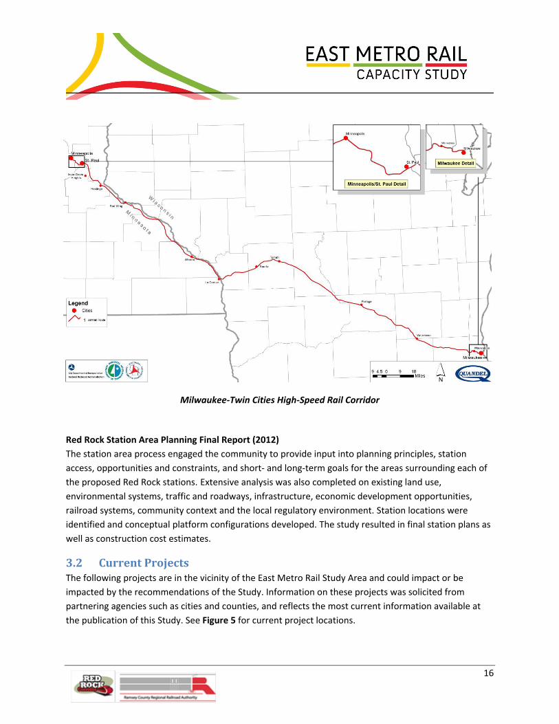
16
Milwaukee-Twin Cities High-Speed Rail Corridor
Red Rock Station Area Planning Final Report (2012)
The station area process engaged the community to provide input into planning principles, station
access, opportunities and constraints, and short- and long-term goals for the areas surrounding each of
the proposed Red Rock stations. Extensive analysis was also completed on existing land use,
environmental systems, traffic and roadways, infrastructure, economic development opportunities,
railroad systems, community context and the local regulatory environment. Station locations were
identified and conceptual platform configurations developed. The study resulted in final station plans as
well as construction cost estimates.
3.2 Current Projects The following projects are in the vicinity of the East Metro Rail Study Area and could impact or be
impacted by the recommendations of the Study. Information on these projects was solicited from
partnering agencies such as cities and counties, and reflects the most current information available at
the publication of this Study. See Figure 5 for current project locations.

17
Figure 5. Current Projects

18
Union Depot
Redevelopment of Union Depot Union Depot is a historic rail depot in St. Paul
that is currently being revitalized as a
multimodal transit terminal. Union Depot will
blend transit modes that exist today with
other s that are programmed in the region's
long range plan in one historic location. This
facility will allow for a seamless transfer
among transportation modes serving regional,
state and community needs. By the end of
2012, the redevelopment of Union Depot will
be complete. The Central Corridor Light Rail
Line will begin service in 2014 in front of the
Depot's Headhouse.
Lafayette Bridge Replacement
The existing Lafayette Bridge crossing the Mississippi River east of downtown St. Paul is being
replaced. The project also includes modification of bridges over I-94 and realignment of adjoining
roadways. Re-decking of the Highway 52 bridges over Plato Boulevard and Eaton Street and resurfacing
of the bridge over Concord Street are also included. Construction of the northbound bridge over the
Mississippi River began in 2011 and will be completed in 2013. Construction of the southbound bridge
over the Mississippi River is anticipated to begin in 2014 and will be completed in 2015.
Warner Road Bridge Replacement at Childs Road
The structurally deficient eastbound span of the Warner Road bridge over the UP, CP, and BNSF railroad
tracks will be replaced. This includes the grade separation of the current at-grade multiuse trail crossings
of the Childs Road on/off ramps and the realignment of Childs Road connections near the east end of
the bridge. Ramsey County is currently working on the final design phase of the project. The project is
planned for construction in 2013, contingent upon the resolution of funding issues.
Trout Brook Boulevard/Regional Trail
The City of St. Paul has been looking at options to extend the Trout Brook Regional Trail south beneath
the Phalen Boulevard bridge over Westminster Junction, along the western side of existing railroad
right-of-way, and along the proposed Trout Brook Boulevard to Warner Road, ultimately connecting the
trail to the Sam Morgan Trail.
Trout Brook Boulevard is the roadway portion of the larger Trout Brook Regional Trail project. Trout
Brook Boulevard would connect University Avenue to Warner Road along the eastern part of the St. Paul
central business district. Trout Brook Boulevard is planned to parallel the existing freight rail corridor

19
Proposed Bruce Vento Trail Rendering (April 2012)
from just south of the Lafayette Road overpass to Warner Road. At this time, it is anticipated that a
bridge will carry Trout Brook Boulevard over the existing Division Street Wye east of Union Depot.
Bruce Vento Bicycle and Pedestrian Trail Connection
The City of St. Paul has initiated
design of a project to connect the
Sam Morgan Trail to the Bruce
Vento Trail. The current bridge
design is a curved, single tower
suspension bridge with a clear span
of 500 feet over Warner Road and
the CP/BNSF freight lines just south
of Hoffman Junction. The location
of the bridge is driven by a
potential future rail flyover in this
location. The city will continue with
design refinement, exploration and
development to address ongoing
issues and concerns related to
surrounding visual, cultural, and environmental resources.
Great River Passage Master Plan
The City of St. Paul developed a draft of the Great River Passage Master Plan in December 2011. The
plan presents recommendations for orienting the city toward the river and integrating new and
enhanced parks and natural areas along all 17 miles of the Mississippi River through St. Paul. The plan is
currently being reviewed by agencies and community groups, and final approval is anticipated in
November 2012. The current draft of this plan is compatible with rail network improvements proposed
in The East Metro Rail Capacity Study.
Central Corridor Light Rail Transit
This 11-mile long transit project between Minneapolis and St. Paul along University Avenue includes
new stations, track, and infrastructure improvements. The project also includes a new operations and
maintenance facility (OMF) located west of Broadway in the vicinity of the Lafayette Bridge. Central
Corridor is under construction and will begin service in 2014.
Newport Transit Station Project
The Washington County Regional Railroad Authority, in partnership with the City of Newport, is
designing a transit station that will be a launching point for future development and enhanced transit
service along the Red Rock Corridor. The transit station will initially have express bus service to St. Paul
with the potential for more service in the future. About a quarter of the site will be used for the transit

20
station and the remaining acres are available for development. Potential uses include rental housing,
such as senior living facilities or apartments, office, and retail. The site is located on an 11-acre parcel on
Maxwell Avenue in the southwest quadrant of the Highway 61/I-494 interchange in Newport.
Construction is set to begin in 2013.
4.0 Project Understanding
4.1 Study Outcomes The project stakeholders, specifically the freight railroads, set forth three required outcomes for this
study. The recommended capacity improvements must 1) maintain on-time performance and hold
freights whole; 2) allow for freight and passenger rail growth; and 3) be subject to conceptual
engineering. A series of technical indicators and methodologies were developed to measure and predict
these outcomes in a simulation model.
All railroads have developed specific technical measures to gauge operating performance. These
measures and their weighting vary from railroad to railroad. For this reason the East Metro Study team
developed a suite of metrics to gauge performance on the freight network and for alternative train
volume and infrastructure scenarios. These metrics include changes to average train speed, minutes of
unscheduled delay per train, percentage occupancy of certain key track sections, etc. This Study shows
average train speeds as the simplest performance indicator for the different infrastructure scenarios.
The simulation modeling exercise began with an “existing conditions” scenario to depict current
infrastructure and train activity. The existing conditions closely resembled actual, on-the-ground
experience, which enabled the Study team to calibrate the model with today’s operation setting the
stage for accurate modeling of future conditions and capacity improvement scenarios. It also
established a baseline from which to measure the impact of future service and infrastructure changes.
The Study team developed five alignment options, which are described in detail in Section 6.1 of this
report. The model was re-run for each of these options to determine the effect the change in
infrastructure would have on train speeds. Subsequent iterations of the model assumed 36 percent
growth in freight traffic, the addition of Red Rock commuter trains and additional Amtrak intercity
passenger trains between Chicago and the Twin Cities. The 36 percent growth factor, which was based
on the individual railroads’ annual growth projections for the next ten years, gained consensus of the
Class I stakeholder railroads. Since this level of growth may not occur in ten years, the study did not
focus on a specific build out year, but instead on the growth so that the recommendations from the
study are valid for whenever 36 percent growth is reached.
The model outcomes, as quantified in average train speeds and delays for the various infrastructure/
passenger service scenarios, were also developed on a railroad-specific basis in order to validate and
21
quantify the impact of the proposed improvements on each railroad. A discussion of each desired study
outcome, based on these factors, is presented below.
Maintain On-Time Performance and Hold Freights Whole
All of the three Class I carriers in the Minneapolis-St. Paul area, CP, BNSF and UP, have experience with
commuter rail and intercity passenger rail on various parts of their networks in the United States and
Canada. At the first stakeholder meetings for the East Metro Rail Capacity Study, it was established that
one mandatory criterion for any improvement proposed in the Study was to ensure that the rail network
would have sufficient alignment, capacity and flexibility to handle both freight and projected passenger
rail services operated over freight rail trackage. The railroads insist that their freight operations not only
be maintained during traditional morning and afternoon commuter operating windows, but also be
minimally disrupted. Safety, of course, was a mandate and on-time performance another predominant
goal. The Study team developed options considering the railroads’ input and the final alignment options
chosen will attain all of these top goals: safe accommodation of both freight and passenger service while
achieving a high level of on-time performance.
Allow for Freight and Passenger Rail Growth
Railroads are very capital intensive. Hauling freight traffic generates the cash flow necessary to pay for
this expensive rail network and its maintenance. In order to maintain profitability, the freight railroads
need to protect their ability to serve their customers today and in the future, with smallest possible
infrastructure investment. If railroads allowed passenger service to exhaust excess rail capacity existing
today, without consideration for the capacity needed to service future freight growth, they would find
themselves having to further invest in their rail network in order serve their core clientele much sooner
than they would otherwise have to and, quite possibly, at a higher cost. Throughout the United States
and Canada where there is a request to operate a passenger service upon privately-owned right-of-way,
as is the case with the Study Area, the freight railroads insist that they maintain capacity for current and
anticipated freight volumes. It then follows that any new alignments or capital improvements
constructed for implementation of commuter rail service should also consider the future freight growth
for the owner of the right-of-way.
As part of the East Metro Rail Capacity Study, multiple meetings were held with field operating officers
and train dispatchers to thoroughly understand and vet all train routing options now available and to
anticipate the impacts passenger service would have upon current operations. The Study team
reviewed and documented the individual railroad service plans. Detailed analysis and computer
modeling was performed and verified by each of the railroads, individually and as a group, for
substantiation of future freight and passenger traffic volumes.
Computer modeling was performed to ensure that identified alignment options would meet the overall
goal of maintaining present capacity and accommodating future growth. The options were tested
against additional goals, including standards for flexibility and operational opportunities involving

22
Elements of Project Specific Agreements
multiple routing options, and routing protocols involving minimal cross over routings. A conceptual
signal system was developed to support each of the alternative alignments. When and where the model
indicated it was necessary, the team further enhanced various track layouts to provide adequate
capacity.
Conceptual Engineering Completed on Agreed-To Capacity Improvements
Throughout the Study process, BNSF, CP, and UP engineering personnel provided valuable input and
guidance to the Study team regarding conceptual engineering. Local Division Engineering Officers’ input
was incorporated as an integral part of the Study team’s design approach for all of the new alignment
options. Railroad personnel passed on valuable local knowledge of specific challenges to railroad
operations in the Study Area. In turn, the Study team considered and addressed these challenges in the
development of track layout and design concepts for each of the locations targeted for major upgrades,
new trackage and/or new alignments. A conceptual signal system was developed to support each of the
alternative alignments.
4.2 Project-Specific Agreements The East Metro Study framework proposes a range of new investments required to accommodate new
passenger rail operations and 36 percent growth in freight rail volumes, which was based on the
individual railroads’ future growth projections, and was agreed upon by all Class I stakeholder railroads.
The infrastructure network changes and the discreet impacts of specific improvements were modeled
considering detailed input from the operating freight carriers and Amtrak. The Study establishes a long-
term vision for such investments as well as a tool to
more specifically model the service impact (and
potential mitigation strategies) of specific new train
operations, whether passenger or freight.
Because the proposed new facilities for new passenger
service involve a number of parties, their development
will necessitate formal, project-specific agreements
between sponsoring public agencies and the rail
carriers. These sponsoring public agencies could include
Amtrak, MnDOT, RCRRA and/or RRCC. The timing of
such improvements hinges on availability of funding for
new passenger rail operations as well as the rate and
nature of freight volume growth. Of course, the freight
rail carriers can independently or collectively invest as
needed in their respective and shared properties to
provide service to their customers.

23
The content and structure of specific agreements to develop new facilities is likely to vary by
circumstance, but such agreements commonly address four main categories: objectives, fixed facility
investments, outcomes, and administrative framework. An agreement starts with clearly outlining
objectives and assumptions, including a description of current and forecasted freight rail services, as
well as passenger rail services. Future service expectations for speed and reliability, as well as
environmental considerations and assumptions for efficient use of existing physical infrastructure,
should be part of the foundation of any agreement.
Ownership and maintenance of newly-constructed infrastructure is also likely to vary by location and
use. As noted elsewhere in this report, much of the East Metro trackage is used in common by two or
more railroad carriers today, and this situation will continue. The long and widespread history for
sharing track in the railroad industry yields a robust and varied set of management and accounting
practices to allocate costs and fairly distribute the burden of facilities maintenance and renewal. Fixed
facility investments should be clearly delineated in each project-specific agreement. Asset ownership,
maintenance and management, as well as methods for allocating both construction and operating costs,
are important elements. For example, if passenger speeds and class of track increase above what is
required for freight, then track geometry and surface is required to be maintained to more precise
tolerances than for freight and will require higher levels of maintenance. This requires an agreement for
who is paying for and/or completing the physical maintenance of the track. Other critical components of
a project-specific agreement might include an understanding of project phasing and service embargo
protocol and limits for rail operations during construction of the project. Procurement guidelines and
engineering standards are other key elements to defining the facility investments.
A mix of public and private funds is likely for most major projects, defined as projects which require
levels of financial commitment and/or high levels of impact. Accountability for the outcome of such
investments, such as service performance, is often the most challenging issue to resolve in finalizing an
agreement between the participants. Use of the simulation model and detailed performance reporting
are two tools for establishing performance goals and providing objective evidence of investment
outcomes. To support the service expectations, the agreement should also address performance
monitoring protocol, mechanics for analyzing service deficiencies, processes to address shortfalls, and
an ongoing structure for consultation among all parties relative to service issues.
Finally, it should be noted that defining the essential features of a specific improvement project is often
easier than developing the complementary administrative framework to make the project happen. This
is particularly true when the number of rail operators is large and many facilities are used in common,
which may raise issues of liability. It also speaks to funding mechanics and responsibilities, as well as the
review and oversight roles of a third party such as Federal Railroad Administration or Federal Transit
Administration. Internal and external communication protocol is critical. Special care should be taken to
carefully address those administrative requirements and to carry forward the collaborative approach
that governed development of this East Metro Rail Capacity Study.

24
4.3 General Rail Operations
Facilities and Track Ownership
Within the primary Study Area, each of the three Class I carriers not only have ownership and use of
their own lines, but also operate over each other’s trackage as is allowed by trackage rights agreements,
striving for a seamless movement of freight traffic through the terminal. Most major rail terminals
within the Unites States operate in this manner enabling efficient traffic movements and facilitating the
interchange of railcars with minimal delays. Typically, in cases where more than one carrier operates
over shared trackage, dispatching is performed by just one of the railroads.
The Study Area boundaries on the CP begin at Fordson Junction, Mile Post (MP) 412, southeast to
Hastings at MP 391.1, a distance of approximately 21 miles. This section straddles Hoffman Avenue,
CP’s MP 408.9, where the railroad’s Merriam Park Subdivision meets the River Subdivision. The BNSF’s
St. Paul and Midway Subdivisions meet at Division Street and parallel the CP’s Merriam Park Subdivision
for approximately half a mile to Hoffman Avenue. South of Hoffman Avenue, the BNSF and CP operate
under a Joint Track arrangement for the next 18 miles to St. Croix. Between Hoffman Avenue and
Newport, approximately 6.5 miles, Track 1 is owned by the BNSF and Track 2 is owned by the CP. East of
Newport, ownership is just the opposite: CP owns Track 1 while BNSF owns Track 2. The two main
tracks separate at Newport and join again at St. Croix Junction. CP’s Track 1 parallels Highway 61 and
passes through Cottage Grove, while BNSF’s Track 2 runs along the Mississippi River. This joint trackage
arrangement ends at St. Croix Junction at MP 392.1. The BNSF’s line continues along the east side of the
Mississippi River while the CP’s crosses the river via a lift bridge and passes through the town of
Hastings. See Figures 2 and 3 for a depiction of these rail alignments.
BNSF dispatches the joint segment between Hoffman Avenue Interlocking and St. Croix Junction, along
with non-shared routes, from its Network Operations Center in Fort Worth, Texas. The CP dispatches the
River Subdivision south of Hastings and the Merriam Park Subdivision from their System Dispatcher's
Office in Minneapolis. All UP routes are dispatched from the UP Harriman Dispatch Center in Omaha,
Nebraska.
The Study also encompassed the Class I railroads’ yard and other rail support facilities. While the BNSF’s
primary classification and hump yard is located in Minneapolis, its support yard at Dayton’s Bluff has key
importance. This active yard supports the auto facility there and handles the interchange of unit train
and regular manifest traffic. It is also used for block swapping and storing and staging trains. Dayton’s
Bluff Yard is located just east of the Hoffman Avenue interlocking and is approximately 2.2 miles in
length.
The CP’s primary classification yard (a rail yard where railcars are sorted and trains assembled onto
different tracks) for the Twin Cities is St. Paul Yard, formerly “Pigs Eye” Yard, and the adjacent Dunn
Yard, located immediately across the BNSF/CP joint mainlines from the BNSF Dayton’s Bluff Yard. (In

25
this report, reference to “St. Paul Yard” will include the entire CP yard and support complex in this area.)
This facility contains a receiving yard, hump, classification tracks, departure yard, local yard,
maintenance of way area, and a key locomotive servicing and shop complex. The hump allows gravity to
provide much of the propulsion needed to move railcars onto the various classification tracks. This yard
is approximately 2.4 miles in length. The CP also operates a busy auto unloading facility at Cottage
Grove, six miles track east from the southern limits of St. Paul Yard off Main Track 1.
The primary focus of the Study was the proposed passenger corridor as described above, but also
included approximately two miles of the UP Mankato Subdivision west of Chestnut Street where this line
follows then crosses the Mississippi River. At Chestnut Street interlocking, the CP Merriam Park
Subdivision begins a climb up the bluff and heads west to the present Amtrak Station at Midway.
Primary UP routes within the Study Area include the Altoona Subdivision that diverges from the BNSF
north of Division Street at Westminster Junction and heads east towards Eau Claire and Chicago; the
Albert Lea Subdivision which begins at Hoffman Avenue and passes through South St. Paul en route to
Mason City, Iowa, and Kansas City, Missouri; and the State Street Industrial Lead which is part of a
through route for trains between South St. Paul and the Altoona Subdivision, enabling the bypassing of
the congested Hoffman Avenue Yard and interlocking. The UP has five freight yards serving the St. Paul
area, three of which are a part of the Study Area. UP’s primary yard is South St. Paul Yard, located on the
west side of the Mississippi River, which serves as a terminating and originating point for manifest trains
and their many transfer jobs. Western Avenue Yard is located along the Mississippi River approximately
two miles west of Union Depot and is a support yard for area industries. Hoffman Avenue Yard, a
medium-sized switching yard located adjacent to CP’s St. Paul Yard, provides storage and interchange
capacity, as well as a location for manifest trains to set out and pick up railcars. See Figure 6 for
Subdivision locations.
The Twin Cities and Western Railroad (TC&W) regional railroad operates into the UP’s Western Avenue
Yard and into the CP’s St. Paul Yard providing interchange service to their shippers, with destinations to
the west reaching out to the South Dakota border. Interchange of manifest carload traffic between
BNSF, CP, and UP is handled by yard jobs, predominantly among three yards: BNSF’s Dayton’s Bluff Yard,
CP’s St. Paul Yard, and UP’s Hoffman Yard. The railroads interchange unit trains at these yards by merely
changing the crews.

26
Figure 6. Subdivisions in the Study Area

27
Through Movements
Within the Study Area, each of the three Class I carriers operates a combination of through movements
and a number of originating and terminating trains. The BNSF operates the majority of through
traffic―as many as 40 to 60 trains per day―between St. Croix Junction and Division Street and beyond
that point by way of either the St. Paul Subdivision or the Midway Subdivision. Intermodal, manifest,
auto and unit trains carrying coal, iron ore, grain, ethanol and other commodities make up the mix of
traffic handled by BNSF.
CP originates and terminates as many as 32 trains daily at their St. Paul Yard: ten trains in each direction
from the south and four to six trains in each direction from the north. CP operates many interchange
and transfer jobs out of the north end of the yard to various locations. CP also handles a number of
through trains through the Study Area, varying from six to ten daily. To and from Minneapolis, through
trains operate over either the BNSF’s Midway or St. Paul Subdivisions and beyond over their trackage
rights on the BNSF.
Having five yards in proximity, the UP’s operation within the Study Area is very complex. The terminal
experiences extended track occupancy of UP trains, not only on UP lines, but also those of CP and BNSF,
due, in part, to the slow speeds dictated for the trackage over which they operate. UP originates and
terminates manifest trains to/from points on their system towards Omaha at Valley Park Yard in
Shakopee, west of the Study Area on the Mankato Subdivision. Railcars from these manifest trains are
transferred between Valley Park and South St. Paul Yards in very long transfers that stop to work at
Western Avenue Yard and Hoffman Yard along the way.
Because the route between Valley Park Yard and South St. Paul Yard is often blocked by these transfer
trains, UP operates many through trains, particularly unit coal trains four days per week, via the State
Street Industrial Track and the Robert Street Lift Bridge over the Mississippi River. Traffic over this bridge
is limited to 10 mph. Loaded trains must pause to attach helper locomotives in order to ascend the
grade to Westminster Junction en route to the Altoona Subdivision. Empty trains pause to detach those
same helper locomotives. The helper locomotives must be repositioned back to where they are needed
for the next loaded train, which is accomplished most efficiently (e.g., not demanding additional
switching or crew costs) by remaining with the unit train as the railcars are unloaded and returned
empty, back to the bottom of the Westminster grade. Through manifest trains also operate via the State
Street Industrial Track when the railcars slated for set out and pick up allow. The number of through
trains via the industrial track varies from four to eight trains daily, depending upon operating conditions
elsewhere, and often includes CP transfers and CP unit trains en route to and from Roseport Industrial
Complex, which is located along the Roseport Industrial Lead south of South St. Paul Yard on the Albert
Lea Subdivision. Transfers and yard jobs also use the State Street Industrial Track to handle traffic
between South St. Paul and Hoffman Yards.

28
Amtrak’s “Empire Builder” has daily service that connects Chicago with the Pacific Northwest on a route
that includes the Twin Cities. Trains #7 and #8 operate through the Study Area between Hastings and
Fordson Junction. These Amtrak trains run over the BNSF-CP joint trackage between St. Croix Junction
and Hoffman Avenue interlocking. At that point, the intercity passenger trains cross over to the CP
Merriam Park Subdivision and pass Union Depot en route to the Amtrak Midway Station. RCRRA is
currently redeveloping Union Depot to become the station stop in the Twin Cities area for Amtrak.
When complete, the Amtrak station at Midway will close and Union Depot will become the Amtrak
station stop for Trains #7 and #8. Modifications to track are currently under construction to
accommodate these maneuvers. The Study team has incorporated these proposed improvements into
the “existing conditions” for this project.
Yard Operations and Interchange
The Study demanded a complete understanding of the three Class I carriers’ expectations for the five
freight yards so that any initiatives for capacity and engineering analysis could adequately address them.
While simulation modeling of all of the tasks each of these yards performs was beyond the scope of the
modeling analysis, an understanding of the daily tasks at each yard, and more importantly, the
challenges encountered when performing these tasks, was required. Yard congestion has a direct impact
upon mainline track occupancy within a rail terminal and sometimes as far as 100 miles outside yard
limits. The simulation modeling exercise did not specifically address the activities within the five yards,
but rather “black boxed” them. In multiple meetings, field operating officers gave the Study team a clear
understanding of the existing service plans in effect and the obstacles hindering their execution. Future
option alternatives need to mitigate these obstacles which hinder fluidity (e.g., locals blocking mainlines
when switching industries, speed limitations of crossovers, no place to meet trains, etc.)
Existing operations in each yard are described below. BNSF Dayton’s Bluff Yard, CP St. Paul Yard, and UP
Hoffman Yard are illustrated in Figure 7.
BNSF Dayton’s Bluff Yard: Dayton’s Bluff’s primary purpose is to serve as a support yard for loading and
unloading autos at the auto facility at the west end. A contract switching service transfers the loaded
railcars from the easternmost tracks of the yard to and from the ramp tracks without impeding other
yard activities.
A secondary purpose of Dayton’s Bluff Yard is for handling manifest trains and interchanging railcars
from them. Crews for up to four manifest trains do work at this yard, setting off and picking up railcars,
primarily for interchange to either the CP or UP yards nearby. If a yard track is open and long enough,
these manifest trains will work off of it. More often, though, the yard tracks are not long enough, so the
manifest trains are forced to occupy Main Track 1, restricting all other BNSF and CP through trains to
Main Track 2. Sometimes, in order to avoid the busy BNSF Northtown Yard in Minneapolis, certain
manifest trains will block swap here. Yard crews deliver railcars from Dayton’s Bluff across the mainlines
to both the CP St. Paul and the UP Hoffman Avenue Yards.
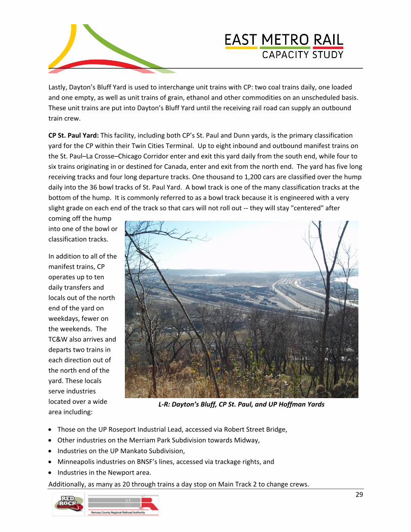
29
L-R: Dayton’s Bluff, CP St. Paul, and UP Hoffman Yards
Lastly, Dayton’s Bluff Yard is used to interchange unit trains with CP: two coal trains daily, one loaded
and one empty, as well as unit trains of grain, ethanol and other commodities on an unscheduled basis.
These unit trains are put into Dayton’s Bluff Yard until the receiving rail road can supply an outbound
train crew.
CP St. Paul Yard: This facility, including both CP’s St. Paul and Dunn yards, is the primary classification
yard for the CP within their Twin Cities Terminal. Up to eight inbound and outbound manifest trains on
the St. Paul–La Crosse–Chicago Corridor enter and exit this yard daily from the south end, while four to
six trains originating in or destined for Canada, enter and exit from the north end. The yard has five long
receiving tracks and four long departure tracks. One thousand to 1,200 cars are classified over the hump
daily into the 36 bowl tracks of St. Paul Yard. A bowl track is one of the many classification tracks at the
bottom of the hump. It is commonly referred to as a bowl track because it is engineered with a very
slight grade on each end of the track so that cars will not roll out -- they will stay "centered" after
coming off the hump
into one of the bowl or
classification tracks.
In addition to all of the
manifest trains, CP
operates up to ten
daily transfers and
locals out of the north
end of the yard on
weekdays, fewer on
the weekends. The
TC&W also arrives and
departs two trains in
each direction out of
the north end of the
yard. These locals
serve industries
located over a wide
area including:
Those on the UP Roseport Industrial Lead, accessed via Robert Street Bridge,
Other industries on the Merriam Park Subdivision towards Midway,
Industries on the UP Mankato Subdivision,
Minneapolis industries on BNSF’s lines, accessed via trackage rights, and
Industries in the Newport area.
Additionally, as many as 20 through trains a day stop on Main Track 2 to change crews.
30
Because of the large volume of train movements, most of which must be conducted at less than 10 mph
due to diverging movements (crossing over from one track to another), CP trains occupy the Hoffman
Avenue Interlocking much of the time.
UP Hoffman Yard: Located adjacent to both the CP St. Paul Yard and the BNSF Dayton’s Bluff Yard, this
yard is utilized to receive interchange traffic from both adjacent yards, sometimes twice per day from
each railroad. This interchange traffic is picked up by the UP transfer trains en route to Valley Park or by
the daily manifest trains to Chicago and Superior, Wisconsin. These transfer trains–two or three per day
in each direction–and the mixed-freight trains from Chicago and Superior also drop off railcars grouped
in a block of railcars for interchange with BNSF and another for interchange with CP. If the Robert Street
Bridge route is blocked or congested, then other through trains will operate through Hoffman Yard
to/from Minneapolis or the Altoona Subdivision.

31
Figure 7. East Metro Rail Yards

32
UP South St. Paul Yard: This facility is on the opposite side of the Mississippi River from the Dayton’s
Bluff and St. Paul yards, so access entails a river crossing either via the Robert Street Bridge or via
Hoffman Bridge on the Albert Lea Subdivision. South St. Paul Yard is the UP’s primary switching yard
within the Twin Cities Terminal.
Three to four manifest trains in each direction originate and terminate at South St. Paul Yard from the
Albert Lea Subdivision, the busiest of UP’s three routes serving this terminal. Another manifest train in
each direction operates to/from this yard via the Hoffman Bridge and Hoffman Yard en route to the
Altoona Subdivision.
A minimum of five transfer/local trains operate northward out of South St. Paul Yard to the UP Western
Avenue and Valley Park Yards and work Hoffman Yard en route. Transfers and locals to/from the
Roseport Industrial District operate southward out of this yard. Additionally, direct interchange transfer
runs to and from the CP St. Paul Yard are made daily to avoid the long back-up move through Hoffman
Interlocking.
Other trains merely pass through South St. Paul Yard, including the four-day-per-week loaded and
empty coal trains to/from the Altoona Subdivision, unit grain trains, the CP Roseport Transfer, and
weekly CP unit coke trains en route to the Roseport Industrial Lead. UP anticipates unit trains of sand
between the Altoona and the Albert Lea Subdivisions will soon operate through this yard, too.
UP Western Avenue Yard: Western Avenue Yard is utilized as a support yard for area industries,
including an auto ramp and a large grain elevator. It is also used to receive daily interchange traffic from
the TC&W transfer train. Transfer trains between Valley Park and South St. Paul Yards set out and pick
up railcars from Western Avenue Yard.
Train Volumes
The Class I carriers and the simulation modeling team collaborated to develop a model that
appropriately addressed train volumes. Each of the stakeholder railroads provided the Study team with
current train operations data as the Study commenced in 2010. Because 2010 volumes represented
recession era train movements, it was agreed to use 2006 volumes as supplied by BNSF as the base
volume for all railroads. As the primary dispatcher for the Study Area, BNSF had train volumes for all the
railroads. That data was then modified to capture anticipated volume increases based growth
projections of each railroad prior to modeling the different future scenarios.
Base train volumes provided to the Study team in the spring of 2010 were as follows:

33
BNSF train along Dayton’s Bluff
BNSF: BNSF’s traffic in the
Twin Cities area is
predominantly through
trains. On average, 50 trains
per day pass through the
Dayton’s Bluff to
Westminster Corridor. BNSF
trains are impacted by the
steep grades up to
Westminster–1.8 percent
and 1.6 percent on the
Midway and the St. Paul
Subdivisions, respectively–
which sometimes reduces
train speeds to 10 mph.
Often, southbound trains are
held at Oakland, at the south end of Dayton’s Bluff Yard, awaiting routing access to St. Croix Junction.
Mainline track occupancy in the Dayton’s Bluff area is often an issue because trains setting out and
picking up railcars foul Main Track 1 for an extended period of time. Most intermodal trains utilize the
Midway Subdivision west of Division Street to access the intermodal yard located on that route. BNSF
interchanges unit trains with CP frequently at Dayton’s Bluff Yard, including five loaded and five empty
coal trains per week. BNSF delivers an occasional eastbound grain train to UP via either Hoffman Yard or
the Robert Street Bridge route.
CP: CP originates an average of 20 trains per day at St. Paul Yard. CP’s volume of through trains varies by
season, but can reach as high as 30 per day. All through trains operate west of Hoffman Avenue via BNSF
trackage rights onto either the Midway or St. Paul Subdivisions. CP operates ten transfer jobs out of the
north end of the St. Paul Yard Monday through Friday. Transfer runs are made to the UP Mankato
Subdivision, to the UP State Street Industrial Lead via the Robert Street Bridge, to its own Merriam Park
Subdivision and to Minneapolis on BNSF lines.
UP: UP operates an average of 24 trains per day through the St. Paul rail terminal. The Albert Lea
Subdivision is the busiest. Three to four manifest trains arrive and depart daily from the south end of
South St. Paul Yard from and to the Albert Lea Sub. Five loaded and five empty coal trains per week
travel between the Albert Lea and Altoona Subdivisions, accessing South St. Paul Yard either via
Hoffman Yard or the Robert Street Bridge route, stopping to add or drop off helper locomotives. There is
a daily manifest train in each direction between South St. Paul Yard and the Altoona Sub, as well as
another between South St. Paul and Superior, all via Hoffman Yard. Two to three empty coal trains per
week travel from the Mankato Subdivision east through Hoffman and South St. Paul Yards en route to

34
the Albert Lea Subdivision. UP operates two to three transfers in each direction between Valley Park
Yard on the Mankato Subdivision and South St. Paul Yard via Hoffman Yard.
Five or six trains per day utilize the UP Altoona Subdivision. Three of these are from the BNSF Midway
Subdivision accessing the Altoona Sub directly at Westminster. Using BNSF trackage rights, UP operates
three to four through trains each day from Hoffman Yard to Minneapolis and Superior. Four to six UP
trains cross the Robert Street Bridge daily to access the State Street Industrial Lead. When traffic is
heavy, UP operates manifest trains between its Mankato and Altoona Subdivisions around the Division
Street Wye via BNSF trackage rights up the hill to Westminster.
The Mankato Subdivision currently has no through trains, but rather only transfer trains from Valley
Park into the Study Area. Six to eight UP transfers and two to four CP transfers operate over the
Mankato Sub daily.
Amtrak: Amtrak operates two daily “Empire Builder” intercity passenger trains between Chicago and
Seattle/Portland through the Twin Cities. The westbound train operates in the late evening from
Hastings over the BNSF-CP joint trackage to Hoffman Avenue where it diverges to the CP Merriam Park
Subdivision en route to Midway Station. The eastbound train operates in the morning, taking the same
route, but in the reverse direction.
Average train volumes per week for each carrier are summarized in Exhibit 1.
Exhibit 1. Average Train Volumes by Carrier
Average Trains per Week
Type BNSF CP UP MNNR TC&W Amtrak Total
Intermodal/Auto 124 42 8 -- -- -- 174
Manifest 73 135 105 -- 10 -- 323
Unit 68 48 12 -- -- -- 128
Local / transfer 3 129 40 4 6 -- 182
Passenger -- -- -- -- -- 14 14
Total 268 354 165 4 16 14 821

35
TC&W: TC&W averages two trains per day through the Study Area. It operates a transfer five days per
week from the Merriam Park Subdivision. This train backs into UP Western Avenue Yard to set out cars
for interchange, then continues to CP St. Paul Yard and returns directly to the Merriam Park Sub en
route to their own trackage west of Minneapolis. TC&W also operates an interchange train between the
CP St. Paul Yard and Minneapolis via BNSF trackage rights six or seven days per week.
MNNR: The Minnesota Commercial regional railroad has trackage rights down the Merriam Park
Subdivision to service the three yards at Hoffman Avenue, but presently does not exercise these rights
with any traffic, except when taking locomotives to CP’s St. Paul Yard for service. Occasionally, perhaps
twice per week, MNNR serves a couple of customers with a small local train it operates from the BNSF
Midway Subdivision to the UP Altoona Subdivision.
Average Daily Train Counts are depicted in Figure 8.

36
Figure 8. Train Counts

37
4.4 Physical Constraints
Drainage/Stormwater
Data from the Minnesota Department of Natural Resources (MnDNR), Federal Emergency Management
Agency (FEMA), and National Wetland Inventory (NWI) was gathered and reviewed to determine
drainage concerns, as well as potential impacts to floodplains, wetlands, and streams. Although these
impacts usually do not create “fatal flaw” situations, they can significantly affect the cost of the
improvements.
Per the MnDNR GIS data, a majority of the existing BNSF and CP tracks east of St. Paul and in Hastings
reside in or near the 100-year FEMA floodplain (see detailed floodplain graphics in Appendix B). The
100-year flood elevations range from 707 feet on the downstream side of the Lafayette Bridge (Highway
52) to 693 feet on the downstream side of the Highway 61 Bridge in Hastings. All flood elevations are
referenced to the North American Vertical Datum of 1988 (NAVD 88). As a result of sections of the rail
line being located in the FEMA 100-year floodplain, it should be understood that the tracks in their
current location may need to be closed during large flood events.
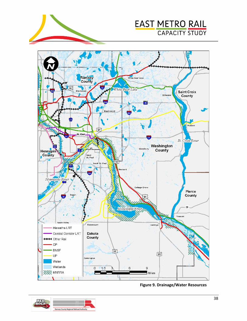
38
Figure 9. Drainage/Water Resources

39
Watershed Districts and Watershed Management Organizations
The Study Area extends into five different Watershed Districts (WDs) and Watershed Management
Organizations (WMOs): Capitol Region Watershed District (CRWD), Ramsey-Washington-Metro
Watershed District (RMWD), South Washington Watershed District (SWWD), Lower Mississippi River
Watershed Management Organization (LMWMO), and the Vermillion River Water Management
Organization (VRWMO).
WDs and WMOS have many similarities, including the requirement to conduct their activities according
to an approved watershed management plan. In addition to plan requirements in statute, metro area
WDs and WMOs must also abide by Minnesota Rules Chapter 8410, which spells out detailed plan
requirements. WMOs differ from WDs in a number of ways:
WMOs are mandatory, not voluntary;
WMOs deal only with surface water, whereas watershed districts manage surface water and
groundwater (metro area counties handle groundwater planning);
WMOs do not have individual taxing authority, unless their joint powers agreement specifically
grants this authority, and most are funded by the municipalities that make up their
membership; and
WMOs are governed by a board appointed by the member municipalities and townships.
Stormwater Policies
The watershed authorities’ policies include run-off rate reduction, volume reduction, minimizing
impervious systems, protecting water quality, ensuring maintenance of stormwater systems and
coordinating with the appropriate cities, townships, counties and Municipal Separate Storm Sewer
Systems (MS4s) to manage stormwater practices within their districts and organizations.
Stormwater Regulation
Permits are required by each watershed authority concerning stormwater management for
construction. Permit review or participation varies on the authority of the organization, as summarized
in Exhibit 2.

40
Little Pig’s Eye Lake
Source: Ramsey Washington Metro Watershed District
Exhibit 2. Permit Authority
Authority Permit
(Disturbing land greater than 1 acre= permit)
Permit Submission/ Review
Capitol Region Watershed District (CRWD)
National Pollution Discharge Elimination System (NPDES) General Construction Permit
CRWD
Lower Mississippi River Watershed Management Organization (LMWMO)
NPDES General Construction Permit
Local authority - no permitting program administered
South Washington Watershed District (SWWD)
NPDES Phase II from Minnesota Pollution Control Agency (MPCA)
SWWD
Ramsey-Washington-Metro Watershed District (RWMWD)
NPDES General Construction Permit
RWMWD
Vermillion River Water Management Organization (VRWMO)
NPDES General Construction Permit
LGU or the VRWMO
Stormwater Management Criteria
Stormwater management plans have
to comply with criteria regarding
stormwater runoff rates, runoff
volume and water quality. Additional
criteria for watershed authorities
involve monitoring methods
(hydrographs), Best Management
Practices (BMPs), run off temperature
control, allowable phosphorus loads
and maintenance. Exhibit 3 illustrates
the criteria specifically referenced by
the different watershed authorities.

41
Exhibit 3. Watershed Criteria
Stormwater Management Criterion Watershed Authority
Runoff Rate All applicable authorities
Runoff Volume All applicable authorities
Water Quality CRWD, RWMWD, VRWMO
Best Management Practices SWWD
Temperature Control VRWMO
Allowable Phosphorus Loads SWWD
Maintenance CRWD
Hydrograph Methods CRWD
Construction Erosion Control VRWMO
Cultural Resources
Implementation of the improvements recommended in this Study will likely require federal and/or state
funding or permitting, thereby requiring the need to comply with federal and state cultural resources
laws, such as Section 106 of the National Historic Preservation Act, the Minnesota Field Archaeology Act,
the Minnesota Historic Sites Act, and the Minnesota Private Cemeteries Act. A review of information
pertaining to known archaeological and culturally sensitive sites and historic structures within the Study
Areas was completed. The purpose was to inform the Study team of the cultural resources in the Study
Area so that it could, to the extent practicable, avoid proposing improvements that would impact those
resources. This would result in: 1) minimizing potential cultural resources issues in future stages of
development, and 2) identifying what cultural resources work may be required for each of the proposed
improvement options prior to implementation.
Most portions of the primary and secondary Study Areas have been subjected to numerous previous
cultural resources investigations, resulting in the identification of close to 900 previously identified
archaeological sites and historic structures within the areas (see cultural resources literature review
reports in Appendix C). The majority of these resources (approximately 98 percent) are historic
structures located within the primary Study Area, particularly surrounding the Robert Street Bridge.
They include a large number of properties that are listed on or are eligible for listing on the National
Register of Historic Places (NRHP), the official list of the nation's historic places worthy of preservation
managed by the National Park Service. The small number of archaeological resources that have been
previously identified within the Study Areas includes NRHP-listed and eligible archaeological sites,
known Native American mound sites, potential burial grounds, and Traditional Cultural Properties
(TCPs). TCPs are properties associated with cultural practices or beliefs of a living community that are
rooted in that community's history, and are important in maintaining the continuing cultural identity of

42
the community. A large proportion of these significant and sensitive sites are within the vicinity of the
Hoffman Avenue Junction and Yard. Figure 10 illustrates concentrated areas of potential architectural
and archaeological resources.
The number of previously identified cultural resources only indicates what is already known about the
Study Areas and does not indicate how many currently unknown archaeological sites and architectural
history properties may also exist; therefore, the true impacts to all potential cultural resources cannot
be known at this time without further analysis, field investigation, and consultation with Native
American tribes, which will be completed during the environmental documentation process (NEPA
evaluation) for any given project.

43
Figure 10. Known Historic and Archaeological Resources

44
Geotechnical
Available geotechnical data in areas of potential track improvements was collected and reviewed, with
particular focus placed in areas of new structures and/or raised or widened embankments. The Study
team obtained this data predominantly through its direct involvement with projects, but also explored
MnDOT boring records. Although poor soil conditions usually do not pose “fatal flaw” issues, they can
significantly affect the cost of improvements.
Bridge structures are commonly supported on driven pile foundation systems. The pile type and depth is
a function of soil consistency/density, and, when reasonably shallow, depth to bedrock. Flyover bridges
entail raised fill approach embankments. The heavy weight of man-made embankments can also induce
settlement when placed over compressible soils, such as clay, silt or peat. Some embankment
settlement is not necessarily problematic. When an embankment is adjacent to a bridge, though, the
difference in settlement between the embankment and the piles from a pile-supported structure
induces “downdrag loads” (i.e., additional downward pressure on the pile). Downdrag load uses up
some of the piles’ capacity, leaving less capacity for the support of the structure.
Within the Study Area, two primary and larger areas of deep-seated compressible soils are known and
well documented: 1) the Hoffman Junction area and 2) the north side of the Mississippi River near
Hastings (see Figure 11). It also is likely that segments along Pigs Eye Lake overlie compressible soils,
although specific information available to the Study team along the rail corridors through this area was
more limited. Surface geology maps published by the Minnesota Geological Survey suggest peats are
likely present in the low area south/southeast of Warner Road. Organic and soft soil deposits would
settle under a fill load, so settlement and downdrag loads would need to be mitigated for any structures
built at any of these locations, either with ground improvement techniques, pile-supported
embankments, or extended lengths of pile-supported structure.
Hoffman Junction
The Study team consulted previous soil borings/cone-penetration-test soundings conducted for Union
Depot, TH 52 Lafayette Bridge, RCRRA property east and west of Lafayette Bridge (for past consideration
of the Central Corridor Operations and Maintenance Facility, since removed from consideration), and a
proposed City pedestrian bridge over the railroad and Warner Road linking the Vento Nature Sanctuary
to the river.
The geology typically consists of surficial fill, giving the land a more level surface, underlain by alluvial
sand deposits that are typically interbedded and/or overlain with organic clay and/or peat swamp
deposits and soft alluvial clays. This general profile continues to the southwest along the Mississippi
River valley. Top of bedrock in the Lafayette Bridge/RCCRA site area is near an elevation of 565 feet and
rises to the east of the Division Street Wye to around elevation 630 feet, based on the proposed
pedestrian bridge information.

45
Hastings
Another area of deep-seated compressible soils is located on the north side of the Mississippi River in
the vicinity of Hastings. Borings had been previously conducted for the new TH 61 bridge crossing the
river and although bedrock is only several feet beneath the surface on the south side, the bedrock depth
is more than 250 feet deep in the north approach area. The current railroad corridor is located in this
north approach area. The soil profile on this north side again consists of sands that are interbedded with
deposits of slightly organic clay to organic clay. Although organic contents are usually less than nine
percent, these clay deposits extend as much as 158 feet below the surface.

46
Figure 11. Other Environmental Issues

47
Environmental
It is recognized that there are numerous environmental factors related to the existing and potential
future rail infrastructure. While these are not being considered in detail at this time, the Study team
conducted a high level screening of environmental factors to help select engineering concepts for
further study. Selected concepts will be subjected to more detailed environmental evaluation in future
phases of project planning.
Through project area research and consultation with local agencies and railroads, the following general
environmental constraints within the project area have been noted, as captured in Exhibit 4. These
constraints are also discussed in the following text.
Exhibit 4. General Environmental Constraints Noted Within the Project Area
Issue/Constraint Location Potential Significance
Wetlands Large wetland complexes throughout project area, along river
Drainage/water quality; wildlife habitat
100-year floodplain Majority of the existing BNSF and CP tracks east of St. Paul and in Hastings reside in or near the floodplain
Flooding of facilities, flood storage
Mississippi National River and Recreation Area (MNRRA)/Mississippi River Corridor Critical Area (MRCCA)
Along Mississippi River for the length of the project area
Potential restrictions on improvements or activities within the boundary
Pigs Eye Lake/Park Southeast of Holman Field (airport) Natural area, heron and egret rookery; endangered species; Superfund/brownfield considerations
Water Resources
Water resources in the Study Area are illustrated in Figure 9. For more detailed floodplain mapping of
the Study Area, please see Appendix B.
Wetlands
Using mapping data from the United States Fish and Wildlife Service (USFWS) and National Wetlands
Inventory (NWI), wetlands were identified within the project corridor. The majority of these identified
wetlands were adjacent to the Mississippi River.

48
Floodplain
Federal Emergency Management Agency (FEMA) 100-year floodplain was identified within the project
area. This floodplain is associated with the Mississippi River. A majority of the existing BNSF and CP
tracks east of St. Paul and in Hastings reside in or near the 100-year FEMA floodplain. The 100-year flood
elevations range from 707 feet on the downstream side of the Lafayette Bridge (TH 52) to 693 feet on
the downstream side of the TH 61 bridge in Hastings. All flood elevations are referenced to the North
American Vertical Datum of 1988. Placement of fill in the floodplain requires coordination with the local
government unit.
Streams and Rivers
Due to the location and size of the project, numerous streams and rivers were identified within the
project vicinity. Obviously, the major river adjacent to the project is the Mississippi River. Other
streams flow under the tracks and outlet into the Mississippi River. The stream crossings could indicate
major culverts and bridges that would need replacement or modification should the rail lines be
reconstructed or expanded in these locations.
Mississippi National River and Recreation Area (MNRRA) and Mississippi River Critical Area (MRCA)
The project is located within the MNRRA and MRCA boundaries. The MnDNR and National Park Service
(NPS) provide oversight of the MNRRA and MRCA program and would review any specific recommended
project with respect to the MNRRA guidelines. The guidelines that are applicable to this project corridor
include:
Item 7c. In planning and designing the construction or reconstruction of all public transportation
facilities which occur within the river corridor, consideration shall be given to the provision of
scenic overlooks for motorists, safe pedestrian crossings and facilities along the River Corridor,
access to the riverfront in public ownership and reasonable use of the land between the river
and the transportation facility.
Native Plant Communities and Rare Features The Minnesota County Biological Surveys (MCBS) produced by the MnDNR identified native plant
communities within the project vicinity. The Ramsey County survey was published in 1994 with the
Dakota and Washington County surveys published in 1997. The majority of the native plant
communities were associated with either the Mississippi River or the bluffs. These plant communities
included oak forests, floodplain forests, dry prairies, grasslands, and wetlands. These plant communities
were identified adjacent to the project area, but were assumed to be outside of the project limits.
When specific projects are identified, a review of the communities adjacent to the tracks is
recommended to determine the extent proposed projects would impact native plant communities.
The MCBS also identified rare features within the vicinity of the project: six animals and fifteen plants.
The potential for impact to these rare features is minimal; however, when specific projects are
identified, a habitat and site review is recommended to rule out the possibility that these rare features

49
reside adjacent to the tracks and would be impacted by project improvements. The Pig’s Eye Island
Heron Rookery Scientific and Natural Area is also located in the vicinity of the project area (Figure 11).
Hazardous Materials
A cursory review of the Minnesota Pollution Control Agency (MPCA) What’s in My Neighborhood?
database revealed several documented hazardous waste sites within the project area. Given the long-
standing industrial and railroad use of the area, this is to be expected. There is one identified Superfund
site in vicinity of the project area, known as the Pig’s Eye Landfill located at Warner Road and Childs
Road just east of downtown St. Paul. It is a heavily vegetated site bounded by a railroad switching yard
to the northeast and Pig’s Eye Lake to the south (Figure 11). A Response Action Plan (RAP) has been
implemented and the site is now in the long-term maintenance and monitoring phase, which is being
managed by the City of St. Paul and the MPCA. The RAP was approved for a specific end use and any
change in use (e.g. right-of-way or easements) would require approval of the MPCA and other regulating
government agencies and might require plan modification.
Right-of-Way
With just a couple of exceptions, most of the construction impacts and permanent infrastructure
required for this project are anticipated to be constructed within the existing railroad right-of-way
whenever possible. Therefore, in most areas, no significant right-of-way or permanent easement
acquisition costs are anticipated. There will be some locations along the project corridor where
temporary construction impacts will fall outside of the existing right-of-way and temporary construction
easements or agreements will need to be secured. This may occur on either/both private property and
local agency land. In areas where construction impacts fall within local agency right-of-way, close
coordination with those agencies will be necessary to negotiate an easement or agreement that will
allow for construction activities to take place but not significantly disrupt the intended use of the local
agency right-of-way. These easements or agreements between agencies are assumed to be secured at
no cost to the project.
Although every effort will be made to stay within railroad right-of-way, there may be areas of right-of-
way acquisition from private property owners. One notable location is in the area south of Cottage
Grove as a result of the proposed addition of tracks along the CP Highway 61 route parallel to Highway
61. This would entail significant rock cut along the bluff and acquisition of a number of acres of private
property. If these or any other acquisitions are required for any particular project and that project is
utilizing federal funding, the requirements of the Uniform Relocation Assistance and Real Property
Acquisition Policies Act of 1970 and applicable state law will need to be met. The Uniform Relocation
Assistance and Real Property Acquisition Policies Act of 1970 is a federal law that establishes minimum
standards for federally funded projects that require the acquisition of real property (real estate) or
displacement of persons from their homes, businesses, or farms. If federal funding is not used, property
acquisition would occur per the policies of the implementing agency.

50
5.0 Study Requirements and Assumptions
5.1 Study Requirements All of the Class I stakeholder railroads agreed to a set of study requirements, starting with
accommodation of both freight and passenger trains. Class I’s also agreed that alternatives must
mitigate the problem of excessive mainline occupancy and provide multiple rerouting opportunities for
flexibility and maximum efficiency. These requirements are discussed below.
Accommodate Freight and Passenger Trains
All of the Class I railroads agreed concepts under consideration in this Study should not only provide
capacity for current volumes, but also accommodate future freight and passenger rail traffic. While it
was understood that passenger trains would be given priority due to their time-sensitive schedules, the
stakeholders agreed that additional passenger service could not be offered at the expense of
deteriorated freight service nor force freight embargoes for significant portions of the day.
Mitigate Excessive Mainline Occupancy
The simulation modeling exercise factored the impact of trains stopped and occupying the mainline
tracks to through train movements in the immediate area, as well as to outer limits of the Study Area.
Instances of this include trains switching cars at CP’s Cottage Grove auto facility and BNSF’s Dayton's
Bluff Yard and trains changing crews at CP's St. Paul Yard. The railroads concurred, based upon the
simulation modeling results and their own experience, that the significant impacts of excessive track
occupancy would be exacerbated with increasing volumes of passenger and freight traffic. Accordingly, a
second requirement for recommendations is that implementation would minimize mainline occupancy.
Provide Multiple Rerouting Opportunities
The railroads also achieved consensus on the observation that having multiple routing options improves
the chances for successfully fulfilling the daily operating plan, particularly since the rail network must
accommodate a myriad of circumstances (e.g., track maintenance activity, inclement weather, and
unplanned spikes in volume) beyond the daily operating plan. Multiple routing options build flexibility
for accommodating rail traffic, allowing maximum efficiency. So, a third prerequisite for
recommendation of an alternative is that it contribute to—or, at minimum, that it not reduce—
rerouting opportunities.
5.2 Study Assumptions
General Operating Assumptions
Forecast increases in rail freight volume were converted to actual train movements by first increasing
train lengths to the maximum allowed by each railroad, and then by adding additional trains to the
schedules. Numerous joint railroad meetings and individual meetings with each of the three Class I
carriers, as well as the short line carrier and Amtrak, confirmed there was consensus that such a plan
would best serve the stakeholder railroads’ customers. When trains had to be added to the schedule, it

51
was done so that trains were fairly evenly spaced. For instance, if a daily train demanded a second daily
“train start”, that second start was assumed to occur 12 hours after the original train was scheduled. If a
train scheduled to run on Monday, Wednesday, and Friday needed additional capacity, the Study team
assumed train starts on additional days of the week. The Study team conducted a number of interviews
and observed operations in the field to gain a thorough understanding of current operations. Study
team members worked closely with field officers of each railroad, spent time in the CP train dispatcher's
office, visited with train dispatchers from all three Class I railroads, and interviewed field engineering
personnel. The team rode a Twin Cities and Western Railroad (TC&W) freight train through a large
portion of the Study Area to observe train operations first hand and a high-rail vehicle to see additional
sections, hitting key areas including Hoffman Avenue Interlocking, Robert Street Bridge, Westminster,
Newport, St. Croix, and Hastings. All major switching and classification yards discussed in Section 4.0 of
this report were toured, except for UP South St. Paul Yard.
The Study team discussed with the railroad personnel not only their standard operating procedures, but
also what variations to their terminal operating plan were available to them as operating conditions
warranted and the types of challenges they encountered daily. To ensure a thorough understanding of
train operations, in every interview, the Study team presented its understanding to the railroads’ field
officers and asked for confirmation that it was correct. If such confirmation could not be given initially,
the Study team asked for clarification until understanding was confirmed. In this way, the team ensured
a thorough and accurate understanding of train operations.
General Routing Assumptions
Train dispatchers and field operating officers reviewed all assumptions made by the Study team
concerning train routings at key junctions, approaches and exits to freight yards, and other traffic
patterns. Delays or routing variations resulting from Amtrak's twice daily service were discussed with
each railroad's operating personnel.
Signaling Assumptions
For proprietary and security reasons, the railroads’ policies did not allow their engineering departments
to share specific railroad signal design, operating characteristics, or other information about their signal
systems for the Study Areas with the Study team. As this report is written the rail industry is undergoing
a major investment and re-design of main line signaling and train control systems as mandated by the
2008 Passenger Rail Investment and Improvement Act. The operations and capacity impact of these
new systems, to be installed by the end of calendar 2015, is as yet uncertain. Thus, the Study team
made a number of assumptions to facilitate analysis of signaling systems, documented in the sections
below.
The preliminary signal layouts for all potential improvement options are based on the current
approximate signal locations as modified by track revisions, and other turnout size and interlocking
revisions. Main track switches which are crossovers, main route diverges or entrances to main facilities

52
are assumed to be powered and dispatcher-controlled. Generally, it was assumed that existing
intermediate signals would remain at their current locations and all main track hand-throw locations
would be equipped with electric locks.
Train speed validation, which results from signal engineering, will be deferred to a future phase when
braking characteristics, optimum signal locations and aspects can be determined based on railroad
operating characteristics and signal design requirements.
Cost magnitude estimates are based on the preliminary signal layout. For costing of the signaling
improvements, all control and wayside equipment is assumed to be new in order to facilitate phasing;
however, phasing costs themselves are not addressed.
Freight Traffic Volumes Existing and Growth Over Time
When this Study was initiated in the spring of 2010, the railroads’ traffic volumes through the Study
Area were decidedly reduced from previous years due to the recession that began in December 2007.
At an early railroad stakeholder meeting, at the suggestion of the railroads, the Study team agreed to
use 2006 as the Study’s base year and project future volumes by building on 2006’s traffic volumes using
anticipated annual growth rates.
The BNSF's Planning Group responsible for in-house simulation for capital expenditures supplied the
records of train movements covering the territory between Westminster and St. Croix. Since BNSF is
responsible for all dispatching within this corridor, not only BNSF trains, but also UP and CP trains
operated on any segment of this corridor were captured in BNSF’s 2006 data. Traffic volumes on other
routes, including the majority of UP routes, were obtained through interviews with field operating
officers. The Study team obtained the 2010 freight service plans for all railroads, then modified them to
accommodate 2006 volumes by assuming either longer or additional trains. If trains in the 2010 freight
service plan had excess capacity, the Study team assumed the additional railcars would be merely added
to trains already in the service plan, making for longer trains. This is the most efficient method for
handling higher volumes because it does not entail additional labor costs. Only when trains reached
their maximum length did the Study team assume additional trains would be added to the service plan
to handle the higher volume of railcars.
The three Class I railroads, BNSF, CP, and UP forecasted growth for the next five years, but not beyond.
The railroads forecasted growth as follows:
BNSF: 5 percent annually next three years, 3 percent annually in years 4 and 5
CP: 5 percent annually next three years, 2 percent annually in years 4 and 5
UP: 3 percent annually next five years
The variance in projected growth rates is due to the type of traffic each railroad handles through the
Study Area. If the year 5 projected growth rates continued for years 6 through 10, the average projected
growth is around 36 percent. The Class I stakeholders agreed that 36 percent was a reasonable volume

53
increase to assume in the Study, but suggested it not be associated with any particular future year.
Many factors influence freight growth, so projected annual freight rail growth rates are debatable
estimates and, particularly for years further into the future, quite speculative. Accordingly, even though
the stakeholder railroads are confident that freight rail in the Study Area grow 36% over baseline
volumes, none were willing to predict in which year that volume would be achieved (in fact, each
railroad may achieve 36% growth for its own traffic in different years.)
The stakeholder railroads and the Study team agreed that any new alignment options would be
modeled assuming freight traffic volumes at 36 percent greater than the baseline volume. This
consensus forecast approximates expected freight activity. Efforts to further refine these projections
would add little value to the modeling exercise given the inherent uncertainties surrounding economic
activity and commodity volume market trends.
Passenger Volumes - Existing and Growth over Time
The only scheduled passenger train, Amtrak's Empire Builder, operated on close to the same schedule in
2010 as it did in 2006.
For purposes of the Study, in addition to the two existing, long-haul Amtrak trains, one eastbound, one
westbound, passenger volume was assumed to include ten weekday Red Rock commuter trains
between Hastings and Union Depot and continuing to Minneapolis, and 12 higher-speed intercity
passenger trains in the Twin City-Chicago Corridor per day, seven days per week. It should be noted that
higher-speed trains would be traveling at conventional speeds through the study area. While these
prospective trains are expected to be classified as “higher speed” (e.g., achieving speeds of up to 110-
125 mph), they are anticipated to run at conventional speeds of up to 79 mph through the Study Area.
For the network to accommodate this volume of passenger trains without embargoing freight traffic for
significant portions of the day nor significantly hampering freight service, it was agreed that another
main track from Hastings to Union Depot would be needed so that one main could be designated as
exclusively “passenger” for specific hours of the day.
6.0 Concept Development
6.1 Infrastructure Options/Potential Improvements
Scheduling/Dispatching
As early model results were generated, the Study team concluded that adopting a railroad service plan
which optimizes train schedules would be a key component to attaining efficiency. Scheduling freight
trains is a complicated task because there are innumerable issues and irregular railroad activities that
can wreak havoc on a schedule if adequate flexibility is not factored in. Within a large metropolitan area
where serving railroads possess multiple routing options, it is essential that originating passenger and
54
freight trains depart on time because the success of a train dispatcher hinges upon trains departing
within the daily slots created for them. Arriving passenger trains also tend to be slotted because their
on-time performance is generally more critical than that of freight trains.
Even with the additional capacity that the various identified infrastructure options would generate, as
freight traffic increases and combines with the impact of commuter and intercity passenger trains, all
the stakeholder railroads should at some point consider the need to jointly implement a Terminal
Service Plan.
The various through trains, which comprise the majority of trains within the Study Area, operate
anywhere from four hours ahead of schedule to as much as 12 hours behind schedule. This variation
can be due to the fact that St. Paul is two days east of many northwestern points of origin (Seattle,
Tacoma, Portland). If the through trains’ scheduled work will cause excessive occupation of mainline
tracks, then the dispatcher tends to slot them further back in order to protect the on-time slots available
throughout the day.
Although not a part of the scope of the Study, model results identified opportunities within the current
railroads’ train schedules. The simulation modeling analysis suggests that some modest schedule
modifications could decrease the average delay minutes per train.
The BNSF Railway (BNSF) train dispatchers are responsible for train movements through the core of the
Study Area: Westminster to St. Croix. The Study team observed that the BNSF and Canadian Pacific
Railway (CP) train dispatchers work well together. The Study team considered input from the three
railroads' train dispatchers responsible for this area when developing alignments for the new options
and when locating placements for crossovers and other turnouts. The dispatchers shared information
about actual attainable train speeds in certain areas which was important for the Study team when
proposing angle of turnouts, as well as signal indications.
The Study team found that the rail network is being dispatched efficiently given the existing
infrastructure. The trains operated through the Study Area make good use of the existing infrastructure,
which is approaching its maximum capacity. Accordingly, there are few operational recommendations to
make that do not also entail changes to the infrastructure. One suggestion for improvement, however,
addresses the CP’s changing of crews on eastbound through trains. As previously mentioned, these
trains stop on the mainline. When they do so, sometimes they do not clear the Hoffman Interlocking,
preventing other trains from entering the interlocking for that 15- to 30-minute period. If CP could pull
farther forward so the end of its trains are out of the interlocking, other trains could get through this
bottleneck during crew changes.
Train Routing
One of the primary goals of the infrastructure improvements within each of the options was to give the
train dispatchers multiple routing opportunities, thereby providing maximum flexibility to the daily

55
operating plan. Key locations addressed were the approach trackage to Union Depot, all trackage
between Division Street and Hoffman Avenue Interlocking, and each of the three interlockings between
Hoffman Avenue and St. Croix.
In order to keep passenger trains moving with minimal or no delay, concepts for priority tracks with
flyover alignments were developed for the routing of passenger trains’ approach to Union Depot and at
St. Croix.
Improved interlockings with supportive signaling will facilitate movement of the many through trains
which pass through the terminal, especially those which need not slow down to access one of the yards.
Improvements to interchanges utilized by both of UP’s through routes will enable higher speeds for their
traffic, as well, although they will still experience considerably slower speeds than BNSF and CP. This is
because yard speed restrictions are in effect over most of the UP trackage within the Study Area.
Lower Cost Capital Improvements
In addition to possible scheduling, dispatching, and train rerouting improvements, it was important to
the Study partners to identify lower cost capital improvements. As an example, the existing rail
infrastructure (e.g., curves in the track) limits the speed at which trains can operate through the East
Metro Study Area. Many of the curves that exist are there because the individual railroads built their
lines keeping to their own rights-of-way. As part of this Study, stakeholder railroads agreed to focus on
what is best for the railroad network as a whole instead of only within specific rights-of-way. This
approach will help to reduce curves and increase speeds and capacity without necessitating significant
property acquisition. The size of turnouts is another example of the existing infrastructure limiting
speeds. Upgrading turnouts is another example of a relatively inexpensive improvement that can reap
capacity benefits to the network; sidings and additional yard track are other relatively low-cost physical
modifications or enhancements that could have significant operational benefits.
Higher Cost Capital Improvements
The Study goals of increasing capacity and efficiency cannot be accomplished without some higher cost
capital improvements. Examples of higher cost improvements are additional mainline track and bridges
or other structures.
6.2 Options Considered for Further Study The initial concepts developed to address Study requirements and goals are described below. It has
been assumed that railroad infrastructure could go on any railroad property, regardless of ownership.
OPTION 1.5: Northern Upgrades
Option 1.5 entails improvements located in the northernmost portion of the Study Area which will
accommodate the 36 percent forecasted growth of freight rail with a slight improvement to average
freight train speeds. Furthermore, it will allow capacity for projected passenger service (in addition to 36

56
percent more freight traffic) with only a minor degradation of freight train speeds. See Figures 12, 14
and 15.
Improvements between Westminster UP MP 1.4 (Lafayette Avenue Overpass) to Dunn CP MP 405.1
(Bailey Road Overpass)
“A” Proposed Passenger Mainline
Approximately 4.5 miles of additional mainline track will allow a new four-track connection to be made
between Division Street and Westminster Junction, lessening the delay and congestion through Hoffman
Interlocking. Furthermore, another mainline, in conjunction with all the other proposed improvements
described below, will provide a priority passenger track from Dunn Yard to Union Depot.
“B” Proposed Passenger Flyover Track
The flyover track will provide passenger trains approaching or departing the Depot a priority track,
avoiding congestion or delay from freight services. The proposed structure is approximately 3,000 feet
in length and will “fly over” three freight tracks. The flyover will be utilized by passenger service only due
to the proposed 2.5 percent grade (2.76 percent grade, compensating for curves), which is more than
freight trains can maneuver, and because it will drop directly into Union Depot, which freight trains need
not access.
“C” Upgrade of all Mainline Switches
Today's routing protocols involve a high number of diverging movements within this area resulting in
speeds of 25 mph or less through switches. The upgrade of these switches will allow for a maximum
speed of 40 mph when making a diverging movement. Trains departing and entering the yard facilities
of all three Class I carriers are limited to 10 mph and, accordingly use up a significant amount of
mainline track capacity. While departures will continue to be at slow speeds, with larger switches,
incoming trains will be able to operate at 20 mph. In Option 1.5 50 to 60 mainline switches will be
replaced. These speed upgrades will constitute a huge improvement allowing for less occupancy of
critical mainline trackage.
In addition to replacing the existing switches with larger-angled turnouts which allows for higher
diverging speeds, the existing crossover plant between 7th Street and Westminster will be reconfigured
to give more and better options for train movements through that area. The proposed improvements
with corresponding signal indications will allow passenger services to operate at 50 mph and freight
services to operate at 40 mph, as opposed to 30 mph for both passenger and freight today.

57
Figure 12. Overall Option 1.5 – Westminster to CPRR Dunn Yard
58
“D” BNSF “Duck Under” Track
The “duck under” track, under the proposed Depot flyover, will provide a direct connection between
BNSF Mainline 2 and the St. Paul, Midway, and Altoona Subdivisions. This connection will allow a higher
speed access to the one plus mile length grade that varies between 1.4 percent and 1.6 percent
ascending going north, that today limits heavier freight trains to speeds less than 10 mph and causes
excess mainline track occupancy. Occupancy in this important area will be decreased with the proposed
plan since it allows for greater speeds at the bottom of the hill and, as described above, greater speeds
through switches. Note that this track is in the 100-year floodplain, so it will warrant additional
attention during preliminary design to determine whether a track raise or drainage improvements
would be desired in order to reduce the risk of flooding.
“E” Proposed CP “Duck Under” Track
This track, also under the proposed Depot flyover, will provide connections for the CP comparable to
those provided for the BNSF, as described above, again increasing capacity. Note that this track, like the
proposed BNSF duck-under track, is in the 100-year floodplain, which should be considered if the project
is progressed to design.
“F” Proposed UP Second Mainline
The second mainline will be approximately 1.9 miles in length. This track will double capacity between
Hoffman Yard mainline connection and Hoffman Bridge at MP 349.8 and provide UP a more direct route
from the yard to its Altoona Subdivision. UP currently uses the Robert Street Bridge to access the
Altoona Sub, often blocking both the BNSF St. Paul and Midway Subdivisions and the CP Merriam Park
Subdivision. This slow process causes delays and impairs throughput of BNSF and CP traffic. Since UP’s
Hoffman Yard is in the 100-year floodplain, this proposed track adjacent to it would be as well. This
should be addressed if the project is progressed to design.
“G” Proposed UP/CP Loop Interchange
The proposed connection will allow faster transfers between the UP South St. Paul Yard and the CP St.
Paul Yard. UP currently uses the Robert Street Bridge for their transfer moves, a very time consuming
maneuver. This new routing affords the transfers between these two yards a reduction in over one hour
of running time, eliminates delay occurrences and delays to other traffic, and will result in reduced
overtime labor costs for crews. Since CP’s St. Paul Yard, like UP’s Hoffman Yard, is in the 100-year flood
plain, this proposed connection is also in an area with a risk of flooding. Unless the elevation of both
yards is raised, it is not beneficial that interchange track between them have a lower risk of flooding.

59
“H” Proposed BNSF Dayton’s Bluff Yard Shift
Currently, Dayton’s Bluff Yard tracks are more widely spaced than necessary. While the tracks
themselves are not excess, the underlying property is under-utilized. Shifting existing tracks 8001-
8006 to the east will free up adequate spacing for two additional mainlines and one new departure
track between Dayton’s Bluff and St. Paul Yards. This will allow for a total four mainlines, as
described above, and increase capacity and terminal speeds. Access roads will also be installed on
the outside of the four mainlines. In this way, existing railroad right-of-way will be better utilized,
allowing more throughput.
“I” Proposed CP St. Paul Yard Additional Departure Track
Currently, the CP St. Paul Yard has five long receiving tracks and four long departure tracks. One of
these departure tracks cannot be fully utilized due to limited horizontal track clearances. Shifting the
BNSF Dayton’s Bluff Yard as described above will provide greater clearance for CP’s departure track
so that it can be used as intended. In addition, a second departure track of approximately 9,300 feet
will help to relieve yard congestion and increase capacity. As part of the yard, this track is in the 100-
year flood plain. Unless CP pursues raising St. Paul Yard, raising this particular track is not deemed
worthwhile.
“J” Proposed BNSF Dayton’s Bluff Yard Lead Extension
One purpose of Dayton’s Bluff Yard is for handling manifest trains and interchanging railcars from
them. If a yard track is open and long enough, these manifest trains will work off of it. More often,
though, the yard tracks are not long enough, so the manifest trains are forced to occupy Main Track
1. Extension of the yard leads approximately 1,500 feet to the southeast will allow BNSF to perform
its switching without fouling the mainline. This improvement will necessitate additional drainage and
a new retaining wall of approximately 1,900 feet.
“K” Relocated BNSF Auto Facility Tail Track A new tail track long enough to accommodate 10 cars and a switch engine will allow more efficient switching between Dayton’s Bluff Yard and the auto facility tracks. While this switching does not normally foul the mainline, the existing switch from the tail track to the mainline will be removed, eliminating the possibility altogether. “L” Proposed Lower Afton Station This proposed station will be a new facility, equipped to handle proposed Red Rock commuter trains.
The station (if constructed) will need to be located between the two innermost tracks and will be
accessible from both. An overhead pedestrian crossing will allow passengers to access the platform
from the parking lot located near Lower Afton Road. Design and cost estimation of the Lower Afton
and other passenger stations are beyond the scope of the Study, but the Study team did determine
viable locations for the stations planned by the Red Rock Corridor Commission. The Red Rock Corridor
Station Area Planning Final Report suggests that the Lower Afton Station platform be centered at

60
Lower Afton Road. The East Metro Study team, however, recommends that this station be
constructed about 1,100 feet southeast of that in order to be compatible with other proposed
improvements (see Figure 13). This is because the station as currently proposed has the potential to
interfere with BNSF Dayton’s Bluff Yard lead mentioned above and make the development of the
priority passenger track leading to Union Depot nearly impossible. It should be noted that this
passenger station and all other proposed infrastructure for passenger service are out of the 100-year
flood plain.
Confirmation of station location will involve additional coordination with local partners and other
affected parties before any decisions are made.
Figure 13. Proposed Lower Afton Station Site
Source: Red Rock Station Area Planning Final Report, January 2012; and East Metro Rail Capacity Study, 2012.

61
“M” Hoffman Interlocking Upgrade
The proposed track through the Hoffman Interlocking will be constructed and existing main tracks
shifted to allow for better horizontal geometry (i.e., straighter tracks). Coupled with the upgrade of
mainline switches through the interlocking, mentioned previously under “Upgrade of all Mainline
Switches”, the improved geometry will increase allowable speeds through Hoffman Interlocking from
10 mph to 40 mph for both straight-through and diverging movements.
Improvements between Newport CP MP 402.0 (I-494 Overpass) to Cottage Grove CP MP 398.2 (Jamaica Avenue Overpass)
“N” Proposed CP Auto Facility Siding
A new 9,000-foot siding will allow the Auto Facility to switch cars without fouling the mainline (see
Figure 16). This improvement will reduce mainline occupancy up to four hours per day.
Improvements on Roseport Industrial Lead - UP MP343.8 Junction Switch on Albert Lea Subdivision
and MP 343.77 at Roseport Industrial Lead overhead Bridge
“O” Proposed UP Second Mainline Connection
By utilizing a segment of the Roseport Industrial Lead, 9,500 feet of a second main track connection
from south of the 117th Street crossing on the UP Albert Lea Subdivision to south of the Highway 52
overpass on Roseport industrial lead can be created (see Figure 16). This double track section will
provide an opportunity for trains of the UP to meet as well as for arriving trains to be held out for
departing trains so that yard space can be created. The first siding now for the meeting and passing
of trains is located at Farmington (MP328.7) which is 19 miles south of South St. Paul Yard.

62
Figure 14. Option 1.5 – CP Auto Facility Siding

63
Figure 15. Option 1.5 – UP
Main

64
OPTION 2.0 River Route along BNSF Mainline / OPTION 3.0 Highway 61 Route along CP
Mainline
Options 2 and 3 are two alternatives that, along with the improvements identified in Option 1.5, will
allow the system to accommodate 36 percent freight growth while increasing increase freight speeds
by 10-13 percent above present-day levels. When new passenger traffic is added to the mix, freight
trains will still be able to operate at slightly higher average speeds than they do today. These options
propose all of the improvements described for Option 1.5, plus the improvements identified for
Options 2 or 3, but only one of the two need be pursued. Many of these additional improvements are
common to both Options 2 and 3, while others pertain to one, but not the other. Both options entail
construction of a third mainline between Newport and St. Croix, but in Option 2, the new mainline
would be along the BNSF route, while in Option 3 it would be along the CP Highway 61 route. While
both alternatives are described, Option 3 was deemed by the railroad stakeholders to be preferred
over Option 2 because it provides all the benefits of Option 2 and a passenger station in Cottage
Grove, but at a lower cost.) Furthermore, since the CP Highway 61 route is at a higher elevation,
Option 3 nearly eliminates the risk that the passenger route through this area would flood.
Improvements between Dunn Yard CP MP 405.1 (Bailey Road Overpass) to St Croix BNSF MP 410.5
(US Hwy 61 Overpass), common to Options 2 and 3
The following improvements are illustrated in Figure 17:
“A” Upgrade of Mainline Switches
Options 2 and 3 call for the replacement of existing mainline switches and the addition of others, 10 to
20 in total. The upgrade of these switches will allow for a maximum speed of 40 mph when making a
diverging movement. This speed upgrade is a huge improvement which will result in less occupancy
of critical mainline trackage.
“B” Proposed Newport Station
Like Lower Afton Station, this proposed station will be a new facility, equipped to handle proposed
Red Rock commuter trains. Newport Station will be located between the two innermost tracks,
similar to Lower Afton Station, with accessibility to both (see Figure 16). An overhead pedestrian
crossing will provide passengers access to the platform from the parking lot located west of the
mainline tracks. This station corresponds with the Newport Station located at the southwest quadrant
of the I-494 and Highway 61 interchange per the Red Rock Corridor Station Area Planning Final Report.

65
Figure 16. Proposed Newport Station Site
Source: Red Rock Station Area Planning Final Report, January 2012.
“C” Proposed Newport Junction Reconfiguration
Today CP and BNSF trains cross from one mainline track to the other at Newport due to their yard
locations being on opposite sides of the mainline. Existing freight speeds are limited to 40 mph due to
horizontal curves. The Study team proposes to lessen the degree of curve and upgrade the switches
to allow for 50 mph movements. While the Newport improvements will not eliminate the overall
conflict of trains crossing from one track to the other, it will lessen congestion and increase
throughput.
“D” St. Croix Junction
St. Croix Junction is one of the biggest bottlenecks in the Study Area. Like at Newport, CP and BNSF
tracks cross over each other here and existing freight speeds are limited due to horizontal curves , but
at St. Croix to just 35 mph. The Study team proposes to lessen the degree of curve and upgrade the
switches to allow for 45 mph movements (see Figure 18). Again, this will not eliminate the overall
conflict of freight traffic changing tracks, but it will help alleviate congestion and increase throughput.
“E” East Hastings The existing mainline crossover will be upgraded and replaced to allow for increase in speed from 30
miles per hour to 50 miles per hour (see Figure 18). The upgraded crossovers will help with lining up
trains for the upcoming river crossing and accessing a proposed Red Rock commuter rail station in
Hastings.

66
Improvements specific to OPTION 2
“F” Proposed Passenger Mainline
Approximately 11.6 miles of mainline along the BNSF route between Newport and St. Croix will be
added to the network (see Figure 17). The new mainline will allow for passenger and freight services
to be separated, each running on their priority track. The passenger track will only be dedicated to
passenger services during hours of passenger operations. Before and after hours of passenger service
this track will be available to freight services and will increase capacity and through put for freight. The
proposed track would be at the same elevation as the BNSF route, so would have the same risk of
flooding.

67
Figure 17: Option 2-Newport to Cottage Grove

68
Figure 18: Option 2 –St. Croix to Hastings

69
Improvements specific to OPTION 3
“G” Proposed Joint Main Along CP Highway 61 route
Approximately 10.1 miles of mainline adjacent to CP’s mainline track between Newport and St Croix will
be added to the network (see Figure 20). The new mainline will allow for passenger and freight services
to be separated, each running on their priority track. The passenger track will only be dedicated to
passenger services during hours of passenger operations. Before and after hours of passenger service,
this track will be available to freight services and will increase capacity and throughput for freight. The
proposed track would be at the same elevation as the CP Highway 61 route which has a minimal flood
risk.
“H” Proposed Cottage Grove Station
Like the two stations discussed previously, the proposed Cottage Grove Station will be a new facility,
equipped to handle Red Rock commuter trains. It is recommended that this station be located between
the mainline tracks with accessibility to both tracks. An overhead pedestrian crossing would provide
passengers access to the platform from the parking lot located east of the tracks. The Red Rock Corridor
Station Area Planning Final Report suggests that the Cottage Grove/Langdon Village State platform be
just north of 96th Street. The East Metro Study team, however, recommends that this station be shifted
slightly to the southeast toward Miller Road, in order to be compatible with the track geometry of other
proposed improvements (see Figure 19). This option was previously considered by the Red Rock team as
the “south option.”
Confirmation of station location will involve additional coordination with local partners and other
affected parties before any decisions are made.
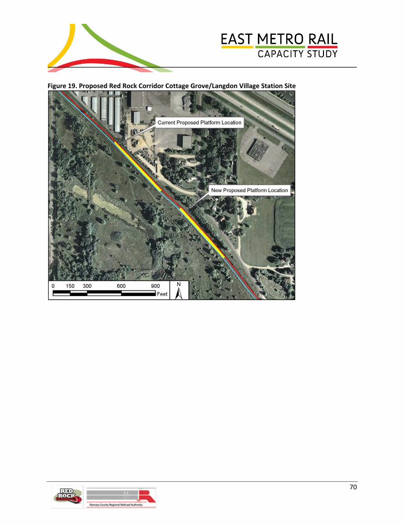
70
Figure 19. Proposed Red Rock Corridor Cottage Grove/Langdon Village Station Site

71
Figure 20. Option 3 – Newport to Cottage Grove

72
OPTION 4.0/OPTION 5.0 St Croix – Hastings Improvements
Options 4 and 5 include infrastructure improvements in the St. Croix and Hastings area that supplement
the previous described options, further increasing capacity and average train velocity in this area. Both
of these options entail the third main along the CP Highway 61 route as in Option 3 and extending it to
Hastings. In both cases the passenger line would be located between the two freight tracks in order to
avoid crossover movements further north. Which track is in the middle (existing or new), though, differs
between Options 4 and 5, as will be explained further. In Option 4, the BNSF River Line is kept at its
current location while in Option 5 it is relocated to the CP Highway 61 route, opening up the BNSF
alignment for possible trail development. While both alternatives are described, Option 5 was deemed
to be preferred over Option 4 because not only does it improve freight speeds more than Option 4, but
it also keeps the proposed passenger track on higher ground, has a lower estimated cost and it would be
possible to add a road adjacent to the tracks for maintenance access.
Option 4 entails all the improvements from Options 1.5 and 3 (or 2, if it were pursued, rather than 3),
plus an additional mainline, flyover, a second bridge over the Mississippi River, and the upgrading of
existing switches. Option 4 would increase overall freight capacity slightly over Option 3 (or Option 2),
although more significantly reduces delays to CP in this area. In Option 4, the new mainline track is the
outside track, so would be used for CP freight traffic. Passenger service would be run in the middle on
the existing CP track which would be upgraded for passenger service.
Improvements between St Croix CP MP 392.1 to East Hastings CP MP 388.7 – Common to Options 4
and 5
The following improvements are shown on Figure 21.
“A” Proposed Mississippi River Bridge
A new Mississippi River Bridge will be built at Hastings to accommodate growing rail volumes. The
proposed structure will be priority to passenger service during the limited hours of passenger operation
and freight will utilize the bridge at other times. The new lift bridge, similar in design to the existing
bridge, will be designed for 40 mph.
“B” Upgrade Existing Mississippi River Bridge
The existing lift bridge over the Mississippi River will be upgraded to allow freight services to run at 40
mph, which will help minimize congestion.

73
Figure 21. Option 4 – St. Croix to Hastings

74
“C” Proposed Hastings Station
The proposed Hastings Station will be a new facility equipped to handle Amtrak and Red Rock commuter
trains. It would be located on the west side of the proposed passenger mainline and existing depot, as
designated in the Red Rock Corridor Station Area Planning Final Report. However, it should be noted
that this station, as illustrated in Figure 22, shows the track going across the existing Mississippi River
Bridge. Stakeholder railroads have indicated, however, that if commuter rail goes all the way to
Hastings, a second Mississippi River Bridge would be needed to effectively segregate passenger rail from
freight traffic.
Figure 22. Proposed Hastings Station Site
Source: Red Rock Station Area Planning Final Report, January 2012
“D” Proposed Hastings Yard Reconfiguration
Hastings Yard will be reconfigured to allow southbound passenger trains to access the existing mainlines
after leaving the station. The reconfiguration will force the yard to be switched from the south and will
utilize the existing lead track. This will keep all yard movements from impacting the passenger services
and will allow for safer operations.

75
Improvements Specific to OPTION 4
“E” Proposed St. Croix Flyover
The flyover will provide passenger trains leaving Hastings station a dedicated track to access the CP bluff
route without congestion or delay from freight services. The proposed structure will be approximately
15,600 feet in length and will “fly over” two freight routes (see Figure 21). The flyover will be utilized by
passenger and freight service, but freight trains will only utilize it when passenger trains are not in
service. Even though the CP track is at a low elevation southeast of St. Croix, lessening the flood risk with
a track raise is not suggested since it would require a corresponding raise of Highway 61’s overpass
bridge.
“F” Proposed BNSF Siding
A new siding is proposed between Pullman Avenue and 103rd Street South (BNSF MP 420.3 and MP
418.4) without affecting each of these at grade road crossings (see Figure 23). This siding will provide a
key location for the BNSF Train Dispatcher for the meeting and passing of trains, particularly when the
proposed passenger trains are operating within the Study Area. It can also be utilized as a holding track
when either the CP St. Paul Yard or the BNSF Dayton's Bluff Yard cannot receive the train.

76
Figure 23. Option 4 – BNSF Siding

77
Improvements specific to OPTION 5
The improvements discussed below are illustrated in Figure 24.
“G” Proposed St. Croix Flyover Like the flyover described for Option 4, the flyover in Option 5 also provides a priority track to access the
CP bluff route without congestion or delay from freight services. The proposed structure will be
approximately 5,800 feet in length and will fly over the proposed CP track approximately one mile north
of St. Croix Junction. As explained for Option 4, Option 5 does not entail raising the CP tracks southeast
of St. Croix since doing so would necessitate costly improvements to Highway 61’s overpass bridge.
“H” BNSF Mainline Relocation
The BNSF’s mainline between St. Croix and Newport that follows the Mississippi River would be
relocated next to the new mainline, shortening BNSF’s route between these two points and increasing
track speed. The relocation minimizes the risk that BNSF’s mainline through this area would need to
close due to flooding. The CP’s mainline would be upgraded with new horizontal track geometry,
utilizing the existing track bed where applicable, allowing for increased speeds. This option entails a
significant rock excavation at a 1:25 slope and a 40-foot wide “bench” at the bottom of the bluff to
capture future rock debris. The proposed excavation and bench will reduce the risk of rock falling on the
tracks, thereby improving safety and decreasing track outages.
With the relocation of the BNSF track, in order for the passenger track to be in between the two freight
tracks, the CP would continue to use its existing track. Passenger service would be run on the new track
immediately adjacent to the CP’s and BNSF would operate the new main track furthest from the river.
“I” (5A only) Access Road
A variation of Option 5, dubbed “Option 5A”, entails building an access road along the St. Croix bluff
next to the three mainlines. Doing so would provide vehicular access to the tracks in this difficult to
reach area, instead of merely high-rail access. Should rail volumes continue to grow, the access road
could be converted for a fourth mainline track bed.
The stakeholder railroads believe there is significant value to having an access road, so have deemed
Option 5A superior to Option 5.

78
Figure 24. Options 5 and 5A – St. Croix to Hastings

79
6.3 Operations Analysis
The Study team analyzed operations of each concept under consideration to provide comparative
analysis and support planning level decisions. Using current and projected freight volumes, the Study
team evaluated the infrastructure concepts with and without additional passenger rail activity. Given
model outputs, the team refined layout alternatives to optimize network designs and presented results
in a series of three stakeholder meetings, the first on April 6, 2011, the second on June 21, 2011, and the
third on April 25, 2012.
This section provides a summary of the modeling efforts of the Study team and the overall findings of
the operations analysis. The complete analysis is captured in East Metro Operations Modeling and
Analysis, Final Report, September 15, 2012, included in Appendix D.
Model Input
The modeling analysis tool utilized a spreadsheet configured for each test scenario, and included several
inputs such as train schedules, run length and warm-up periods, link speed/link grade and
acceleration/deceleration data, lift bridge schedules, routing, and locations of interest. Each input is
described below.
Train Input Schedules
The following railroad schedules were input to the model:
Amtrak (Empire Builder and higher speed service)
BNSF
CP
MNNR
Red Rock
TC&W
UP
All trains were set up on a weekly basis and included: direction, type, length, start time, start location,
stop location, and, if applicable (trains with multiple stops), dwell time. The schedules were compiled
using data from several different sources as well as field observations. Once approved, the baseline
input schedule was expanded to represent 36 percent growth. The future growth scenarios assumed
train lengths no longer than the maximum train lengths allowed by the railroads today. In the future, the
railroads may equip their networks to handle longer trains. New train control systems may be developed
and implemented which change train handling methods. Future changes to safety regulations may
impact railroad operations. The modeling team did not attempt to capture the myriad future
developments which would possibly alter operations, but rather assumed rail operations would
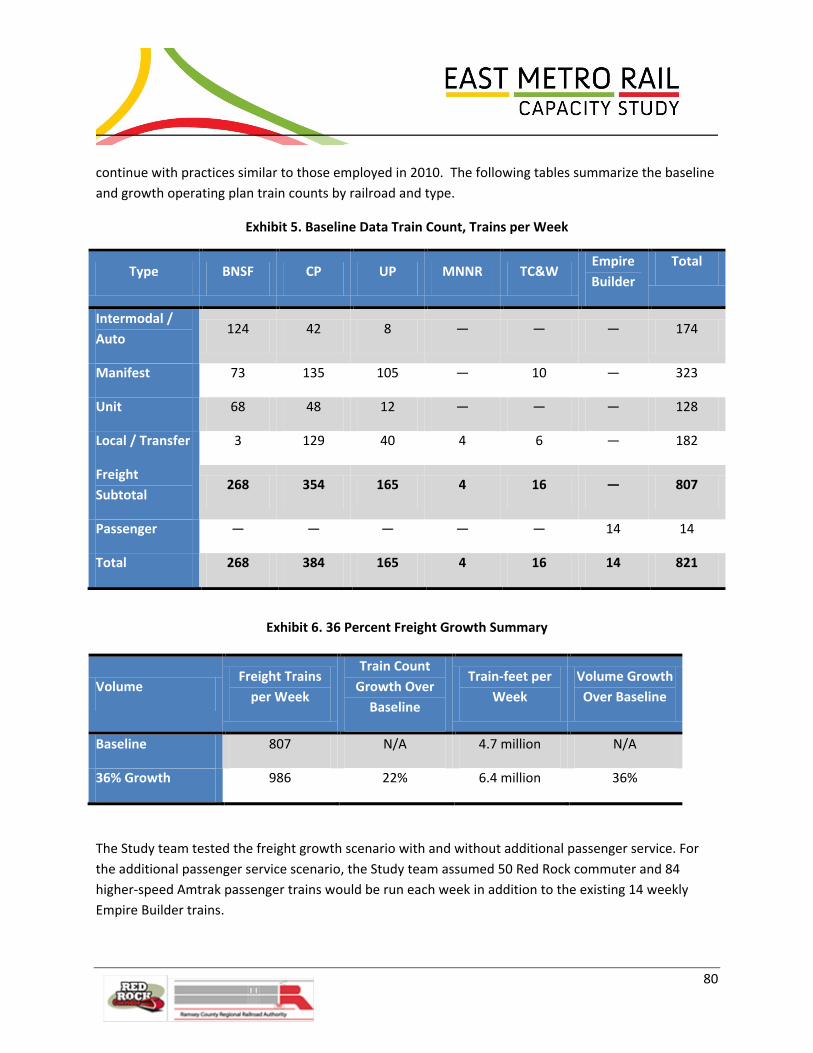
80
continue with practices similar to those employed in 2010. The following tables summarize the baseline
and growth operating plan train counts by railroad and type.
Exhibit 5. Baseline Data Train Count, Trains per Week
Type BNSF CP UP MNNR TC&W Empire
Builder
Total
Intermodal /
Auto 124 42 8 ― ― ― 174
Manifest 73 135 105 ― 10 ― 323
Unit 68 48 12 ― ― ― 128
Local / Transfer 3 129 40 4 6 ― 182
Freight
Subtotal 268 354 165 4 16 ― 807
Passenger ― ― ― ― ― 14 14
Total 268 384 165 4 16 14 821
Exhibit 6. 36 Percent Freight Growth Summary
Volume Freight Trains
per Week
Train Count
Growth Over
Baseline
Train-feet per
Week
Volume Growth
Over Baseline
Baseline 807 N/A 4.7 million N/A
36% Growth 986 22% 6.4 million 36%
The Study team tested the freight growth scenario with and without additional passenger service. For
the additional passenger service scenario, the Study team assumed 50 Red Rock commuter and 84
higher-speed Amtrak passenger trains would be run each week in addition to the existing 14 weekly
Empire Builder trains.
81
Run Length & Warm-up Period
The model run length was either set at six days or three days. In both cases, the start day (Sunday or
Wednesday) was used as a “warm-up” day. The six-day scenarios were called “week long runs”. Over the
course of this project it became apparent that the run length requirement was only three days. The
week long runs took much longer for the model to execute and exactly mirrored the results reported in
the three-day runs. Accordingly, after this was determined, the shorter timeframe was used for
subsequent simulation runs. Wednesday through Friday was used, the busiest days in the railroads’
schedules.
Link Speed, Link Grade, Acceleration/Deceleration Data In addition to the master train operating plan, model inputs required data to represent how fast a train
travels on a specific section of track. This speed data (in mph) was input by train type and tied directly
back into the physical rail network model file. Acceleration and deceleration information (mph/second)
was also input by train type, as well as the exit speeds for trains traveling on a positive grade.
Lift Bridge Schedules
This model input included a schedule for potential track outages, such as the Hastings Lift Bridge. This
input provided information that represented a time when trains were unable to use a section of track
(i.e., when the bridge is lifted trains must wait to cross).
Routing Inputs
For train operational routing decisions, the model used two inputs: priorities and preferences. Passenger
trains were assigned the highest priority; their scheduling requirements were addressed first, keeping
their network delays at a minimum. Conversely, empty unit trains were scheduled last. The model
assumed that any train could use any track, regardless of ownership.
The model also used routing preferences when making routing decisions. Routes with fewer diverging
moves were preferred unless the alternate route saved significant time. In addition, routes with fewer
sidings were preferred unless significant time was saved using a siding. Routes that allowed a train to
enter the Study Area immediately over (potentially faster) routes that required the train to be “held
out” of the Study Area (i.e., held at the next siding upstream) were also preferred.
Data Collection Nodes
This input data described specific locations of interest during the model run. This was used during
analysis to provide trains per hour (TPH) calculations for critical areas of the network.
Model Layout and Analysis Scenarios
In addition to the model input file, each analysis scenario also included a network layout. This file
represented the physical network within Ramsey, Washington and Dakota Counties and was used to
represent the potential infrastructure changes needed for operational improvement. Originating from a
hand-drawn sketch, this baseline schematic-style network drawing evolved significantly with each layout

82
configuration test (see Figure 25). The network’s major areas of interest included: Midway Subdivision
at Westminster, Merriam Park Subdivision, Robert Street Lift Bridge, State Street Industrial Lead, BNSF
Dayton’s Bluff Yard, CP St. Paul Yard, UP Hoffman Yard, UP Albert Lea Subdivision, CP Hastings Lift
Bridge, UP South St. Paul Yard, BNSF St. Paul Subdivision/CP Highway 61 route, Cottage Grove, St. Croix
Junction, and CP Hastings Yard.

83
Figure 25. Model Baseline Layout
The network file included speed information, track length information, as well as trackage rights. Tracks
were grouped for safe following distances and accurate occupation delays. This file was verified
internally with end-to-end network distance calculations and exchange between modeling and design
staff on the Study team. For every new network file the Study team used custom tools to generate a

84
routable network. This routable network was then used in conjunction with the model input file to
perform a model run (a “scenario”).
Over the course of this Study, several scenarios were created to better understand how new passenger
traffic affects the freight carriers in this area and what infrastructure changes would have optimal
impact. Each layout option included scenarios with and without new passenger traffic. For all the
baseline scenarios, 36 percent growth scenarios were also created. In addition to baseline and growth
scenarios, model scenarios were also created with randomness built into their operating schedule,
meaning that trains were not assumed to adhere to the schedule perfectly and that unscheduled trains
occurred on a variable basis. These random runs were required by rail stakeholders to meet a
robustness requirement and facilitate confidence in model results. It was not uncommon for a single
analysis-set to have over twenty scenarios.
Verifying scenario results was a complex process involving the compilation of results from all scenarios
and close coordination within the Study team and with stakeholders to trouble-shoot issues and build
confidence in explainable results. The scenario verification process and final model results provided
valuable feedback for both the Study team and the key stakeholders.
Network Configurations and Performance Measures
This section provides a brief description of the five different network configurations tested during the
operations analysis and how those configurations were measured. As noted, scenario tests were
performed on each of these networks with and without new passenger traffic against a baseline level
and 36 percent growth operating plan.
During analysis, several different outputs were used to understand results. One important output was
average train speed, this metric was output by train, train type (passenger, freight), and railroad. In
addition to average train speed, average congestion time per train was also used as an important
performance metric. This output had both planned and unplanned delay caused by unavailability of
track when entering the network or resuming travel after a planned delay (i.e. crew change or station
stop). Like average speed, this metric was also output by train, train type, railroad, or origin/destination
node. These key outputs, in addition to summary tables and detailed train logs, provided the ability to
clearly rank and understand scenario results. It should be noted that although model input and output
was reviewed with stakeholder railroads throughout this Study, they will still likely wish to conduct their
own modeling as certain projects move forward to preliminary engineering.
Option 1—Existing Conditions
This was the baseline network configuration, or the current-day infrastructure of East Metro.
Option 1.5
This option had increased crossover speed, from 25 mph to 40 mph, and all design improvements in the
Hoffman Avenue/ Dayton’s Bluff area. In addition, this option then added a new mainline flyover track

85
that served as a direct link to Union Depot. This new mainline then continued down the Dayton’s Bluff
area to Newport. Beyond Newport, this option added a siding at Cottage Grove to enable routing
options around the CP auto facility. Elsewhere, a direct connection was added between CP St. Paul Yard
and the UP Albert Lea Sub, a second UP mainline of approximately 1.9 miles in length was added
between Hoffman Yard and Hoffman Bridge, and 9,500 feet of a second UP main track was added in the
area of the Roseport industrial lead. All other network infrastructure was assumed to be unchanged.
Option 2
This option included all the first-step infrastructure enhancements added in Option 1.5. Past Newport,
this option extended the new mainline track along the present day BNSF route, providing double-track
to St. Croix junction. It then merged at Hasting Bridge. See Figures 17 and 18.
Option 3
Similar to Option 2, this option included all the first-step infrastructure enhancements added in Option
1.5. This new mainline track then continued from Dayton’s Bluff to Newport and then down on the
present-day CP Highway 61 route, adding track and infrastructure changes to the Cottage Grove area.
See Figure 20.
Option 4
This is the full build-out layout configuration, it had all of the improvements described in Option 3 (new
mainline direct from Union Depot, double-track CP Highway 61 route, Cottage Grove siding) in addition
to a new BNSF siding on the BNSF St. Paul Subdivision. It also had double-track over the Hastings Bridge
and a flyover at St. Croix that tied into the new CP Highway 61 route mainline. See Figures 21 and 23.
Option 5
An alternative to Option 4, Option 5, too, has all the network improvements that were added to Option
3 and has double-track over the Hastings Bridge and a flyover at St. Croix. Option 5 further aimed to
optimize the network with track modifications in the area between St. Croix and Newport, specifically,
relocating the BNSF St. Paul Subdivision to the CP River Subdivision. In this option, the BNSF route along
the river is no longer used for rail traffic. With the addition of two, rather than one, new CP Highway 61
route mainline tracks, there are differences between Options 4 and 5 with respect to how the St. Croix
flyover connects with the tracks leading to Hastings Yard and BNSF tracks to Chicago. Additionally, this
network calls for several new crossovers at Cottage Grove. A variation of Option 5, Option 5A includes
an access road next to the tracks in the St. Croix area, as well as all of the improvements described for
Option 5. (The model does not capture Option 5A’s access road.) See Figure 24.
Analysis Results and Stakeholder Input
Simulation modeling efforts for this project culminated in three railroad stakeholder workshops. The
first meeting occurred in April of 2011. The objective of this meeting was to provide a detailed look at
the modeling process and review results at an 80 percent completion mark and evaluate them for
reasonableness. A second meeting, in June 2011, was a follow-up meeting to outline the additional
86
infrastructure changes proposed during the first analysis and summarize updated model results. Overall,
it was very important for the Study team to get modeling analysis verification and “buy-in” from all
participating railroad carriers. The Option 5 concept was conceived after June 2011. Accordingly,
stakeholders met a third time in April 2012 to be briefed on these proposed improvements and
associated modeling results.
Railroad Coordination Meeting, April 6, 2011
The purpose of this meeting was to provide railroad stakeholders with a detailed first-look at the
modeling process and proposed infrastructure designs. Time was spent reviewing model assumptions,
train operating plan inputs, and measures of performance. Model animations were available for review
and verification purposes.
The Study team showed that without changes, average train speed will begin to degrade before the
freight growth volumes are reached, even without additional passenger traffic. To maintain current
velocity, the railroads must make some infrastructure changes. The model also predicted that adding
new passenger traffic without any infrastructure improvements will further degrade freight capacity.
Contrary to intuition, initial modeling results indicated that Option 4 seemed to be less effective with
added passenger traffic than Options 2 and 3. Option 4 was expected to be the best performing layout
for all railroads due to its extensive track build-outs and flyover at St. Croix; however, the model showed
there was more unplanned delay with this layout. Looking deeper into the issue, the Study team
identified that the BNSF St. Paul Subdivision became very congested due to CP’s (and all new passenger
trains) easy access to the Highway 61 route. For this reason, Options 2 and 3 were outperforming Option
4 with new passenger traffic.
Using these important modeling insights, the Study team reconsidered the area at St. Croix and further
fine-tuned all layout configurations. The final layout configuration designs were then analyzed and
results presented at a second railroad stakeholders workshop in June 2011.
Railroad Coordination Meeting, June 20, 2011
This was the second meeting to review layout designs and modeling analysis results. The Study team
presented an explanation of how each option was modified, using lessons learned, from the first set of
analysis presented in April 2011:
Option 1 - no change
Option 1.5 - Added southernmost UP siding and track
Option 2, Option 3, Option 4
o Improved Cottage Grove Station location and track alignments
o Updated crossover locations
o Expanded model layout, included universal crossovers at East Hastings

87
Option 4 Additional Modifications
o Changed flyover configuration on CP Highway 61 route at St. Croix
o Added second CP River Bridge at Hastings
Given these changes, the Study team compared these results to the first set of runs and showed
specifically how the results were affected by scenario layout changes. Overall average speed increased.
In addition, Option 4 was, as expected, the best performing option.
Information was also presented on overall average speed for BNSF, CP, and UP as well as average
congestion time. In addition to results related to optimizing the layout configurations, the analysis team
outlined the following major take-away observations.
Cottage Grove Auto Facility
Based on the train schedule, the model output showed the mainline is occupied for four to six hours
between 4:00 pm and 1:00 am, reducing railroad operations to a single track. In addition, there was a
local that occupies that same track 3:00 am to 5:00 am three days per week.
Dayton’s Bluff Yard
Based on the train schedule, working at Dayton’s Bluff yard during the time frame of 3:00 pm to 10:00
pm dramatically reduced the capacity of Hoffman Interlocking.
Hoffman Interlocking
Velocity of the Hoffman interlocking was driven by the diverging speed of the turnouts. All proposed
layout options have #20 turnouts which allow for high speed diverging routes. As traffic grows, the CP
will use Joint Main 2 the majority of the time for changing crews.
System Recovery
Light traffic counts between 6 am and 9 am result in excess capacity for all options which allowed the
railroads to clear traffic before morning. Heavier traffic counts between 3 pm and 6 pm complicated the
afternoon rush more than the morning rush for all options.
88
Follow-Up Analyses
This section describes the follow-up analysis that occurred after the completion of the main analysis.
These scenarios looked into further network design changes regarding specific areas of the network.
Option 5 Analysis
This follow-up analysis looked at an alternative to the Option 4 network. Using the main East Metro
model developed to analyze Options 1, 1.5, 2, 3, and 4, the Study team tested Option 5. This option, as
an alternative to Option 4, changed only one area of the network: the tracks between Newport and St.
Croix. The goal of Option 5 was to provide better routing in this busy corridor. Hoping to cut down on
travel time and provide more direct routes, the Study team expected Option 5 to outperform Option 4.
This analysis was performed to quantify (and verify) the improvement of Option 5 over Option 4.
Railroad Coordination Meeting, April 24, 2012 and Stakeholder Meeting, April 25, 2012
At these meetings, the Study team reviewed layout designs for Options 1.5, 2, 3 and 4 and introduced
Option 5, which had been discussed previously with the railroads, but not the other stakeholders.
Modeling analysis results were shared which showed new results testing Option 5 as the other options
had been.
As expected, the modeling results showed a network performance improvement in Option 5 over
Option 4. The networks are comparable when run against baseline data. With the freight growth
scenario, however, Option 5’s percent change of average freight train speed over baseline is two points
better than Option 4’s. The biggest differential in average freight train speed is in the +36 percent
growth scenario with new passenger traffic: Option 5’s improvement over baseline average freight train
speed is three points better than with Option 4. Since neither Option 4 nor Option 5 networks are at
capacity with the baseline traffic data, it takes additional growth volume to highlight the benefits of
Option 5. The results from this analysis show that with higher traffic volumes, Option 5 has higher
average speeds than Option 4. Average congestion per train, however, is slightly higher with Option 5
than with Option 4. Accordingly, one might conclude that Options 4 and 5 are comparably optimized.
One factor that is not captured in the model, however, is maintenance vehicles’ use of track. Since an
access road in the St. Croix area is possible with Option 5 (dubbed “Option 5A”), but not with Option 4,
under Option 5A maintenance vehicles would use the road, rather than rail, keeping tracks open for
train traffic longer. Considering this additional information, the Study team concludes that Option 5A is
preferable to Option 4.
Differences between Option 4 and Option 5 included:
Two additional tracks added to existing layout in corridor between St. Croix and Newport.
Option 4 only had one additional track along the CP Highway 61 route.
In Option 5, the BNSF river route is no longer used for rail traffic. In Option 4, this track is used
and has an additional siding.

89
Results Summary
The following charts show the overall system summary results.
Exhibit 7 summarizes the model results, showing the effects on average train speed for all trains
(including passenger) and for freight trains when adding 36 percent freight growth. Option 1 would be
expected to perform well below the baseline speed of 22.1 mph, while all other options would be
expected to operate at average speeds above the baseline.
Exhibit 7. Model Results, Passenger Traffic = Empire Builder Only
Base Volume 36% Growth Volume
Infrastructure Average Train
Speed
Average
Freight Train
Speed
Average Train
Speed
Average
Freight Train
Speed
% Change of
Average
Freight Train
Speed Over
(Under)
Baseline
Option 1 22.3 22.0 20.3 20.1 (9%)
Option 1.5 24.4 24.2 23.3 23.0 5%
Option 2 25.7 25.4 25.1 24.8 13%
Option 3 25.8 25.4 24.5 24.2 10%
Option 4 27.5 27.1 26.5 26.2 19%
Option 5 27.5 27.1 26.9 26.6 21%
Baseline for comparison
Slightly below baseline
Well below baseline
Above baseline
Exhibit 8 shows the effects on average freight train speed when adding Red Rock Commuter Rail and
higher speed intercity passenger rail services. Option 1 would be expected to cause a change in average
speeds of 19 percent below the baseline, followed by Option 1.5 at 4 percent below baseline. All
remaining options would generate positive change in speed over the baseline, with Option 5 performing
the best with 18 percent.

90
Exhibit 8. Model Results , Passenger Traffic = Empire Builder, Red Rock and HrSR Intercity
Exhibit 9 offers a comparison of average freight train speeds for all of the proposed options, with and
without new passenger service. As shown, Option 1 is below the baseline and all other options are
above with 36% higher freight volumes. When new passenger trains are added to the mix,
improvements beyond those in Option 1.5 are needed to maintain current freight speeds. Options 4 and
5 are predicted to experience the highest average speeds overall.
Exhibit 9. Comparison of Average Freight Train Speeds for Proposed Options
0.0
5.0
10.0
15.0
20.0
25.0
30.0
Option 1 Option 1.5 Option 2 Option 3 Option 4 Option 5
mp
h
Average Freight Train Speed
Base, no newpassenger
36% Growth, nonew passenger
36% Growth, withnew passenger
Baseline

91
The following exhibits summarize expected average speeds and average congestion, with and without
passenger rail service, for each of the Class I railroads (BNSF, CP, UP). Average speed and congestion
(delay) are factors indicative of how efficiently, timely and reliably a freight system can operate (i.e.,
deliver goods). The results generally support the overall findings that Option 1 would be expected to
result in the lowest speeds and highest congestion. Conditions improve with the other options, with
Option 5 exhibiting the greatest increase in speeds.

92
Exhibit 10. BNSF Average Train Speed and Average Congestion

93
Exhibit 11. CP Average Train Speed and Average Congestion

94
Exhibit 12. UP Average Train Speed and Average Congestion

95
Growth Analysis
At the April 24, 2012 railroad coordination meeting, the rail stakeholders expressed a desire to
understand the volume of traffic the current network could accommodate; at what level the service
levels substantially deteriorate. Accordingly, the Study team used the model to analyze the effects of
substantial traffic growth within the Study Area. Building upon the existing current-day network
configuration (Option 1) and the 36% growth scenario, subsequent 48%, 59%, 71%, and 86% growth
scenarios were created using a set of future-growth assumptions. As with the original modeling exercise,
all rail yards were “black boxed”, as were areas outside the Study Area, meaning that the model
assumed trains could freely flow into and out of the yards and into and out of the Study Area. It is the
modeling team’s consensus opinion, though, that some of these “black boxed” areas, particularly the CP
St. Paul Yard would not readily accommodate growth, particularly high levels of growth.
Key metrics like average train speed and network congestion were again used to identify network
performance. Additionally, to better understand the network’ “trouble-spots”, this modeling effort
aimed to clearly identify areas of the network that will become the most congested as corridor traffic
volume increases. Four analysis scenarios were created to represent future network growth at 48%,
59%, 71%, and 86% above baseline volumes. Volume was added based the modeling team’s
observations and research of actual freight rail volumes since the initial modeling was begun in 2010.
The following outline summarizes these overlying growth assumptions:
Intermodal, manifest, unit oil and auto parts traffic is growing
Unit coal traffic is decreasing
CP St. Paul Yard is already near capacity, so can accommodate few additional originating or
terminating trains
CP through trains must use Joint Main 2 for crew changes
Summarizing results of the new scenarios with previous runs for baseline volume and 36% growth, the
model clearly showed significant system deterioration as freight volumes increase. The following charts
clearly illustrate this result.

96
Exhibit 13. Congestion Will Rise with Freight Volume Growth
With each incremental level of growth, the model predicts an increase in congestion time for the
existing network. From the baseline scenario to the 86% growth scenario, the total congestion time
increased by a factor of 16. (For the two heavy traffic days tested, Thursday and Friday, as volumes were
increased from baseline to 86% growth, total daily congestion grew from 15 hours to 243 hours.) Note
that the rate that congestion increases is higher between 48% and 59% and between 71% and 86%.
0:00:00
0:07:12
0:14:24
0:21:36
0:28:48
0:36:00
0:43:12
0:50:24
0:57:36
1:04:48
1:12:00
0% 15% 30% 45% 60% 75% 90%
Ave
rage
Co
nge
stio
n p
er
Trai
m (
h:m
m:s
s)
Congestion Will Rise with Freight Volume Growth
Volume Growth over Baseline
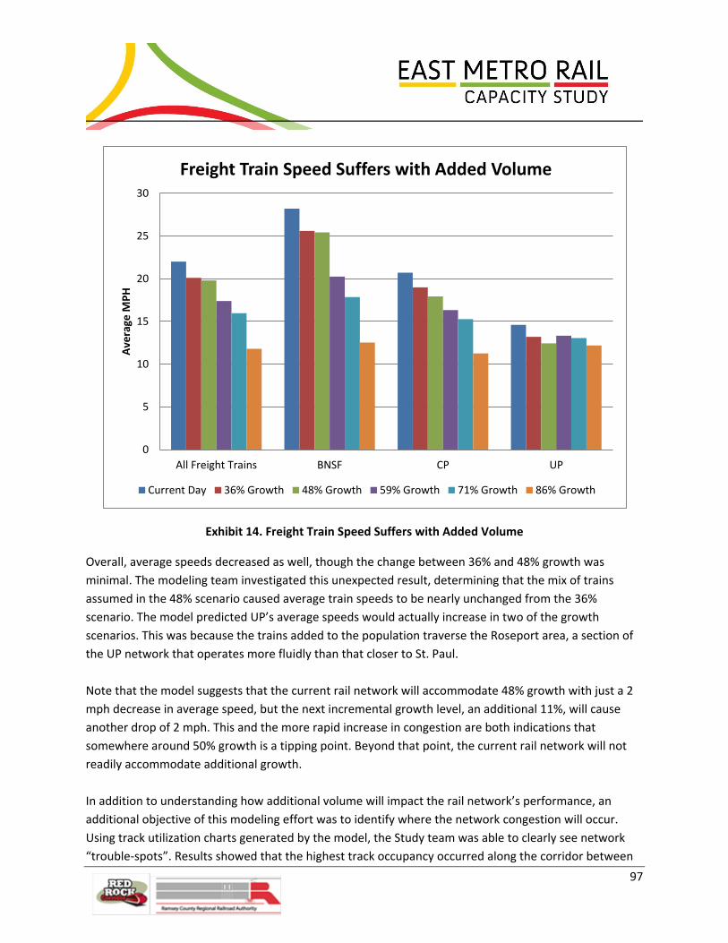
97
Exhibit 14. Freight Train Speed Suffers with Added Volume
Overall, average speeds decreased as well, though the change between 36% and 48% growth was
minimal. The modeling team investigated this unexpected result, determining that the mix of trains
assumed in the 48% scenario caused average train speeds to be nearly unchanged from the 36%
scenario. The model predicted UP’s average speeds would actually increase in two of the growth
scenarios. This was because the trains added to the population traverse the Roseport area, a section of
the UP network that operates more fluidly than that closer to St. Paul.
Note that the model suggests that the current rail network will accommodate 48% growth with just a 2
mph decrease in average speed, but the next incremental growth level, an additional 11%, will cause
another drop of 2 mph. This and the more rapid increase in congestion are both indications that
somewhere around 50% growth is a tipping point. Beyond that point, the current rail network will not
readily accommodate additional growth.
In addition to understanding how additional volume will impact the rail network’s performance, an
additional objective of this modeling effort was to identify where the network congestion will occur.
Using track utilization charts generated by the model, the Study team was able to clearly see network
“trouble-spots”. Results showed that the highest track occupancy occurred along the corridor between
0
5
10
15
20
25
30
All Freight Trains BNSF CP UP
Ave
rage
MP
H
Freight Train Speed Suffers with Added Volume
Current Day 36% Growth 48% Growth 59% Growth 71% Growth 86% Growth

98
the BNSF Midway Sub and Dayton’s Bluff. The Study team hypothesized that St. Croix Junction would be
one of the more congested areas, but its track occupancy was projected to be less than 40% (used as a
threshold level for concern). The team dug deeper to understand why. The model only accepts trains
into the system when there is room for them. Since St. Croix is near the model’s outer limits, the model
assumed trains to be held outside the modeling limits, rather than accepting them into the St. Croix area
with congestion. This kept the predicted track utilization through St. Croix Junction down to some
extent. Additionally, because the track in this area is approved for speeds greater than in some other
areas of the network and because there are no yards, major customers or crew change points to
demand stopping trains, the model predicted trains would clear out of St. Croix Junction relatively
quickly. In fact, the model predicted that the St. Croix area would handle some of the highest train
volumes of the network with relatively low track occupancy. St. Croix’s congestion manifested itself in
ways other than in high reported track utilization, such as delays to train starts and predicted speeds
lower than the maximum speed allowed. With these insights, the modeling team concluded track
occupancy should not be the sole metric for identifying trouble spots.
Model outputs confirmed the areas the Study team had previously identified as network trouble spots.
The most congested areas of the network, based on the track occupancy predicted by the model and on
other indications of congestion, such as daily train counts per track and delays to train starts, are as
follows:
Hoffman Interlocking
Dayton’s Bluff
Cottage Grove
St. Croix Junction
The growth analysis modeling effort illustrates how the rail network in the Study Area would perform
with a steady increase in corridor volume, given the assumption that rail yards would be able to
accommodate the future growth of corridor traffic and that all traffic can freely flow into and out of the
Study Area. At the 86% growth level, the model predicts the network will experience a 46% reduction in
average speed, with all rail carriers’ average speed hovering around the 12 mph mark. Clearly, network
performance will greatly suffer as significant freight growth is introduced into the system. In reality, yard
capacities and/or other “black boxed” areas may fail before the corridor network does. Due to these
model limitations, the Study team expects that the model projects network performance optimistically,
that performance at some “black boxed” areas might deteriorate faster than at other portions of the
network. Accordingly, the Study team suggests that the reader consider these predicted metrics as a
“best case scenario”, that actual network performance would likely be worse than reported due to
capacity restraints of “black boxed” areas.

99
6.4 Role of Stakeholders in Concept Development
This Study is unique in that private Class I railroads were active in the development of the proposed
infrastructure options. The involvement detailed in Sections 2.3 and 6.3 provided valuable input on
Study assumptions and validity to the model that served as the basis for the selection of
recommendations. In addition, input from other stakeholders including cities and neighborhood groups
like the Lower Phalen Creek Project was also considered alongside the more technical railroad
information. This provides credibility to the Study recommendations and provided the foundation of a
partnership moving forward.
7.0 Concept Recommendations
7.1 Conceptual Engineering Conceptual engineering was conducted to determine constructability of the proposed infrastructure
improvements and to support cost estimates. Due to the wide geographical area covered by the Study,
the conceptual engineering design has been segregated into seven locations, some with alternate
options, as described below and illustrated in Figure 26.
Location 1 has been advanced to approximately 30 percent track design and 10 percent structure design
between East Hastings to Innovation Road along the CP River Subdivision and BNSF St. Paul Subdivision
and entails the following improvements:
Upgrade the existing #15 crossover at East Hastings with a proposed #24 universal crossover in
order to increase the allowable operating speed through the control point from 30 to 50 mph.
Reconfigure Hastings Yard to force all switching of the yard to the south end, segregating yard
operations from passenger service and, thereby, improving safety and operational efficiency.
Construct a new Mississippi River Bridge at Hastings north of the existing bridge, similar in
design to the existing lift-span bridge. The second bridge, designed for 40 mph, will allow
passenger trains to cross the river without impacting freight movements. Upgrade existing
Mississippi River bridge to 40 mph, as well, through improvements to the rail joints at the ends
of the lift span.
Option 4 – Construct a third main track between Hastings and Innovation Road designed for
passenger service to operate at 79 mph and freight traffic to operate at 45 mph. The proposed
track will fly over the BNSF track approximately 1,000 feet north of St. Croix Junction and will be
on proposed retaining wall or bridge structures starting just north of the Hwy 61 Bridge and
ending approximately 2,000 feet south of Keates Avenue (near 3M property). The new main
track is anticipated to be dedicated to passenger service during peak passenger hours, but used

100
Figure 26. Concept Engineering Locations

101
for freight traffic the rest of the time. Option 4 does not include any significant changes to the
existing CP and BNSF main tracks, which will continue to operate at 45 mph as they do today.
Option 5 – Construct a third main track between Hastings Yard and Innovation Road, relocate
the BNSF main track east of the new passenger main track, and upgrade CP’s main track. The
proposed alignments will allow passenger services to operate at 79 mph and freight services to
operate at 59 mph. The proposed track will fly over the proposed CP track approximately one
mile north of St. Croix Junction. Relocation of BNSF’s main track will decrease its route between
St. Croix and Newport by approximately 1.4 miles and increase track speed. Changes to the
existing track geometry of the CP main track, utilizing the existing track bed wherever possible,
will allow for increased train speeds. This option entails a significant rock excavation ranging
from 50 to 110 feet high at a 1:25 slope and a 40-foot wide bench at the bottom of the bluff to
capture future rock talus. The proposed excavation and bench will reduce the risk of rock falling
on the tracks, thereby improving safety and decreasing track outages. The engineering plan set
for.
Option 5A – Add a 14-foot access road along the east side of the proposed BNSF track in
addition to improvements of Option 5. The access road will allow vehicular access to tracks
along the bluff between St. Croix and Innovation Road, an area limited to only high-rail access
today. If future train traffic volumes warrant a fourth main track, the access road could be
converted to another track bed. The engineering plan set for Location 1 for Option 5A is located
in Appendix E.
Location 2 has been advanced to approximately 10 percent design between Innovation Road and 80th
Street along the CP River Subdivision and entails the following improvements:
Construct third main track along CP River Subdivision designed for 79 mph passenger operating
speed and 59 mph freight operating speed. Construct a second bridge over Jamaica Avenue to
accommodate the proposed main track. Construct proposed tracks and modify existing CP
tracks to form a 9,000-foot clear siding at the CP auto facility which will allow CP to deliver and
pick up cars without fouling the main track.
Option 5 – In addition to the above improvements, relocate BNSF main track to the east side of
the proposed passenger main track, which entails a third bridge over Jamaica Avenue. The
engineering plan set for Location 2 Option 5 is located in Appendix F.

102
Location 3 has been advanced to approximately 10 percent design between 80th Street and the south
end of Dunn Yard along the CP River Subdivision and BNSF St. Paul Subdivision and entails the following
improvements:
Construct third main track along CP River Sub, designed for 79 mph passenger operating speed
and 59 mph freight operating speed. Install proposed #24 crossovers at Newport.
Option 5 – In addition to the above improvements, relocate BNSF main track to the east side of
the proposed passenger main track. The engineering plan set for Location 3 Option 5 is located
in Appendix G.
Location 4 has been advanced to approximately 30 percent track design and 10 percent structure design
between Dunn Yard and Westminster along the CP Merriam Park Subdivision and BNSF St. Paul
Subdivision and entails the following improvements:
Construct proposed tracks and modify existing tracks to allow for a proposed four main track
connection between Lower Afton and Westminster. Construct proposed BNSF yard leads on the
southeastern portion of Dayton’s Bluff Yard and shift existing yard tracks in Dayton’s Bluff Yard
to accommodate for the four proposed main tracks and a proposed CP departure track in St.
Paul Yard, allow for a reconfigured yard layout, and resolve horizontal clearance issues for CP’s
current departure track. Construct proposed BNSF auto facility tail track. Construct proposed
CP departure track along the northeast side of the existing St. Paul Yard. Construct proposed UP
main track along the east side of Hoffman Yard. Construction proposed yard leads on the north
end of Hoffman Yard. Upgrade Hoffman Interlocking by constructing proposed track and
shifting existing main tracks to allow for better horizontal geometry and increase crossover
sizes, resulting in increased allowable crossover speeds of 40 mph compared with existing
allowable crossover speeds of 10 mph. Construct proposed east leg of Division Street Wye
connection. Construct of proposed crossover plant between 7th Street and Westminster. The
proposed main track alignments will allow passenger services to operate at 50 mph and freight
services to operate at 40 mph. The engineering plan set for Location 4 is located in Appendix H.
St. Paul Depot Flyover (Location 4A) – In addition to the many Location 4 improvements
described above, construct proposed Passenger Flyover from the west end of Hoffman
Interlocking to Union Depot tracks. The proposed structure, approximately 3,000 feet in length
with grades adequate for only passenger service, will allow passenger trains to fly over the
proposed BNSF - CP joint main tracks 2 and 5 and west leg of the Division Street Wye. The
proposed Passenger Flyover will allow passenger services to operate at 30 mph. The
engineering plan set for Location 4A is located in Appendix I.
Location 5 has been advanced to approximately 30 percent track design and 10 percent structure design
between Warner Road and Park Junction along the UP Albert Lea Subdivision and entails the following
improvements:

103
Construct a second main track from northeast of the Hoffman rail bridge to the north end of
Hoffman Yard, continuing the second main track construction from Location 4. Construct a
UP/CP interchange track between an existing CP yard track and the proposed UP second main
track. The proposed alignment will allow freight traffic to operate at 20 mph. The engineering
plan set for Location 5 is located in Appendix J.
Location 6 has been advanced to approximately 30 percent track design and 10 percent structure design
around UP Albert Lea Subdivision and Roseport industrial lead and entails the following improvement:
Construct 9,500 feet of a second main track connection from south of the 117th Street crossing
on the UP Albert Lea Subdivision to south of the Highway 52 overpass on Roseport industrial
lead. The proposed alignment will allow freight services to operate at 40 mph. The engineering
plan set for Location 6 is located in Appendix K.
Location 7 has been advanced to approximately 10 percent design between 103rd Street overpass and
the at-grade crossing with Pullman Avenue along BNSF St. Paul Subdivision and entails the following
improvement:
Construct a 10,000-foot clear length siding from northwest of the 103rd Street overpass to south
of the Pullman Avenue at-grade crossing. The engineering plan set for Location 7 is located in
Appendix L. Note that the improvement in Location 7 is only applicable to Option 4.
A detailed description of civil and structural standards and assumptions used for engineering design can
be found in the Rail Design Memorandum in Appendix O.
7.2 Cost Estimates The Study team prepared cost estimates for each location and option as summarized in Exhibit 15.
Quantities were based on the engineering conceptual designs and unit costs were based on costs
recently experienced in the rail industry. Costs are stated in 2011 dollars. No attempt was made to
escalate the costs or to anticipate future changes in conditions that could occur between 2011 and date
of construction. Because Option 5A was deemed preferable, reported cost estimates reflect Option 5A
which incorporates all of the improvements identified in Option 1.5 and Option 3. A contingency of 20
percent is included to cover unidentified items due to the level of current design.
It should be noted that the $827 million cost estimate accounts for all improvements recommended in
this study to be constructed at one time. Actual construction, however, can be deferred until the need
for network improvements is more imminent. The nature and timing of volume growth will impact those
needs. It is also possible that the need will not arise for every proposed improvement. Availability of
funding will also play a role in determining when construction will occur. For these reasons, phased
implementation of the recommendations is likely. Phased construction could entail design and
implementation of some temporary rail improvements and multiple workforce mobilizations which can
lead to higher costs.

104
Detailed cost estimates can be found in Appendix P, but are summarized as follows:
Exhibit 15. Cost Estimates (2011 Dollars in Millions)
Location Location Description Improvements Option 5A1
1 Hastings to St. Croix New Mississippi River Bridge2
$483
Rehab Mississippi River Bridge
St. Croix flyover
Passenger mainline
Upgrade switches
Hastings Yard improvements
Relocate BNSF
2 Cottage Grove Passenger mainline
$66
Jamaica Ave. structure
CP 9000-foot siding
New crossovers
Relocate BNSF
3 Newport Passenger mainline
$62 New crossovers
Relocate BNSF
4 Hoffman Interlocking Shift Dayton’s Bluff Yard
$122
BNSF Auto Facility tail track
BNSF lead track extension
Two new mainline tracks
New CP departure track
Hoffman crossovers
Westminster upgrades
Upgrade switches
4A Union Depot Flyover2 $61
5 Hoffman Yard CP/UP interchange $12
UP double-track
6 Roseport UP double-track $21
Total $827 1Option 5A includes all of the improvements identified in Options 1.5 and 3. 2Needed only for additional passenger traffic

105
7.3 Recommendations Freight growth is almost certain to occur within the next five to ten years and beyond. Additional
passenger service, while desirable to a number of stakeholders, is less certain and the timing is more
uncertain. Accordingly, the Study team recommends that the railroads, RCRRA and other stakeholders
strive to make the improvements proposed in Option 1.5 (except for the Depot flyover), which should
allow the system to maintain baseline service levels with 36 percent freight growth. Since an efficient
rail network generates public benefits (e.g., economic competitiveness), as well as benefits to the
railroads themselves, we recommend that Federal and/or State funding be sought whenever possible to
augment funding provided by the railroads, even if no new passenger service is forthcoming.
Maintaining a robust rail network in the Twin Cities that can accommodate future volumes efficiently
will help to discourage diversion of freight rail traffic to other modes or to alternative rail routes. In this
way, the investments will help the region to remain competitive.
If and when new passenger service is planned, it is recommended that the Depot flyover and other
improvements from Options 3 and 5A be pursued. Because improvements to the rail network are likely
to be made over the course of several years, if not decades, conditions may change significantly in the
meantime. It would be prudent to refresh the Study periodically, particularly the modeling of the
network, to determine whether the proposed improvements continue to promise to optimize the
network given current and forecasted conditions. Likewise, stakeholder railroads will likely wish to
revisit the assumptions and operations, particularly in the context of adding passenger rail to the
system. Although elements of the Study may need to be revisited over time, the recommendations
serve as the overall “master plan” for rail improvements. To document that stakeholder railroads have
agreed these recommendations represent a baseline set of improvements for future analysis that will be
needed as additional passenger service proceeds toward implementation, a Memorandum of
Understanding (MOU) is currently being developed. The MOU will memorialize both the process for
implementing additional passenger service and the Study.
A comparison of all the options considered as part of this study is summarized in Exhibit 16.

106
Exhibit 16. Option Summary Matrix
Study Option
Option Performance Relative to:
Cost Throughput/
Mobility Movement
Acceptability to Property Owners
(Freights)
Potential for Environmental Impacts
Cultural Resource Sites1
Consistency with Regional Plans
Assessment Overall Ranking
Low Medium High
1.5- Northern Upgrades
$226M
Allows network to maintain current
service levels with 36% freight growth
Acceptable
Minimal
Most improvements within existing railroad right-of-way
Floodplains present
Moderate number of previously identified
sites Consistent
Most improvements are needed in order for freight service to maintain service as volume
grows. Exception is Depot flyover which can be deferred until new passenger service is
implemented on the corridor.
X
2.0- River Route along BNSF
Mainline N/A
Allows network to
improve current
service levels with
36% freight growth;
comparable
performance to
Option 3
Option 3 preferred
Moderate
In floodplain, wetlands; higher flood risk.
Moderate number of previously identified
sites Consistent
Does not allow for passenger station at Cottage Grove. Has new mainline at lower elevation
(higher flood risk). Option 3 was deemed preferable to 2 by railroad stakeholders and
Study team.
X
3.0- Highway 61 Route along CP
Mainline $118M
Allows network to improve current
service levels with 36% freight growth
Deemed preferable to Option 2
Minimal
Generally out of floodplain and wetland areas.
Lesser number of previously identified
sites Consistent
May be deferred until either Red Rock Commuter service or additional intercity passenger service
to Chicago is implemented. X
4.0- St. Croix – Hastings
Improvements N/A
Allows network to improve current
service levels (more than either Option 2
or 3) with 36% freight growth.
Option 5A preferred
Moderate
In floodplain, wetlands; higher flood risk.
New river crossing
Has most previously identified resources of
all options. Consistent
Has new mainline at lower elevation (higher flood risk) and does not allow for access road.
Option 5A was deemed preferable to 4 by railroad stakeholders and Study team.
X
5A- St. Croix – Hastings
Improvements $483M
Allows network to improve current
service levels (slightly better than Option 4)
with 36% freight growth.
Deemed preferable to Option 4
Potentially significant
Requires significant rock cut on the river bluff
Floodplains and wetlands present
New river crossing
Significant number of previously identified
sites Consistent
May be deferred until either Red Rock Commuter service or additional intercity passenger service to Chicago is implemented. If either proposed
passenger service does NOT go through Hastings, the second Mississippi River Bridge can be
forgone.
X

107
7.4 Ranking of Improvements Because the Options studied and modeled bundled a number of proposed improvements, the benefits
of any individual improvement was not captured in our analysis. Similarly, costs were estimated by
location, rather than by each individual project. Accordingly, the Study did not generate a formal cost-
benefit analysis to justify a ranking of all the various improvements proposed. The Study team, however,
using its prior industry experience, understanding of modeling results and grasp of the costs involved,
consider the following list a fair ranking of the most cost-beneficial improvements. Each ranked
improvement is expected to cost under $50 million―some well under―and could be taken on as
funding is identified and secured:
1. Construct Cottage Grove siding: A relatively inexpensive siding would free up valuable mainline
track several hours each day.
2. Shift Dayton’s Bluff Yard tracks, extend BNSF lead track and remove mainline switch from
auto tail track: While shifting Dayton’s Bluff Yard provides minimal benefits of itself, it would
pave the way for the addition of future mainline tracks and for CP yard improvements.
3. Build UP/CP interchange and UP’s second mainline through Hoffman Yard: The interchange
would shave time off of the transfer of cars between UP and CP, while the additional track
capacity would help to make Hoffman Yard more efficient.
4. Build a second BNSF mainline track from Dunn Yard to Warner Road and a new CP departure
track: Both improvements would improve fluidity through the Hoffman Interlocking area.
5. Construct Hoffman Interlocking crossover plant and second CP mainline track: Optimizing the
size and spacing of crossovers through the interlocking would speed traffic in this congested
area.
6. Upgrade Westminster infrastructure: Having four mainlines through this area with upgraded
switches would provide additional capacity and allow faster diverging movements.
7.5 Phasing of Improvements The recommended improvements, Options 1.5, 3 and 5A are phased improvements of a master plan for
the East Metro area. The improvements proposed in Option 1.5 are suggested to be completed first,
with the extension of passenger track into St. Croix proposed in Option 3 to follow next, and the further
extension of the passenger track to Hastings, the new Mississippi River Bridge and the relocation of
BNSF track to the CP Highway 61 route to be constructed last. The Depot flyover portion of Option 1.5
could also be included in a later phase, timed when sufficient additional passenger rail traffic into the
Depot which justifies the investment is planned to begin. The specific trigger for the flyover is not
known, but as each additional train/service is developed, the need for the flyover and other
improvements will be determined jointly with the railroads.

108
Implementation of the improvements proposed in Option 1.5 could further be phased. In fact, the
ranking of improvements as suggested in Section 7.4, is one way that Option 1.5 could be phased into
more manageable, fundable pieces. Certain of the improvements must necessarily occur prior to others,
such as the shifting of Dayton’s Bluff Yard tracks must be done before a third or fourth mainline is built
through that area and before a new CP departure track is built.
Details of phasing the proposed improvements further than outlined above is beyond the conceptual
level engineering performed in the Study, but would entail planning for temporary tracks, switches, etc.
which would be required so that the rail network could remain operational throughout construction.
This type of detailed phasing information would be coordinated with owner railroads.
8.0 Next Steps
One of the goals of the Study was to develop sufficient analysis to identify potential projects that could
be developed as dollars become available. The opportunity to apply for various funding is enhanced by
having a study like this that outlines a planning process, provides recommendations grounded in
technical analysis, and has involved key stakeholders in the process of evaluation. Again, the
involvement of private Class I railroads in the Study sends a clear message to potential funding providers
that there is potential for public/private partnership, and that overall improvements and costs are
generally appropriate.
To take that first step toward public/private partnership, MnDOT on April 24, 2012 initiated the first of
many meetings to discuss the principles and mechanics for integration of passenger and freight rail in
the Twin Cities. Ultimately, the goal is to develop a Memorandum of Understanding (MOU) that will
cover passenger rail activities, freight rail preservation and enhancements, and joint venture projects to
advance rail system capacity and use in the Twin Cities. The MOU would be between MnDOT, involved
public agencies, and the freight railroads. This MOU will lay an overall foundation upon which project-
specific agreements can be built.
Once the agreements are in place, preliminary and final engineering, environmental analysis, and
construction can take place. Each of these next steps is discussed in the following sections.

109
Exhibit 17. Study Process and Next Steps
8.1 Plan Implementation
Finding the resources to fund the overall improvements identified in the Study will be challenging.
Several of the improvements identified have the potential to provide direct benefit to the Class I
railroads and could be undertaken by the private entities based on a business case for the
improvements. Other improvements may not be needed until the increase in passenger rail service is
implemented.
As the RCRRA and other funding partners (MnDOT, Amtrak, Metropolitan Council) consider the benefit
of providing passenger rail service in the Study Area, this Study provides corresponding estimated costs
of the recommended infrastructure improvements. These costs do have the potential to “skew” the
cost effectiveness of a specific passenger rail project since they also include costs for improvements to
address the freight capacity needs of the East Metro rail network that a single passenger project could
have difficulty funding. However, this Study does meet the goal of identifying these costs to allow the
agencies to find opportunities for other sources of funding.
It should be noted that the proposed improvements also have the potential to reduce the cost of freight
service and could be viewed as having an economic value to the movement of freight in and through the
state, benefiting shippers. Efficient movement of freight via rail benefits the public too, by keeping our
economy competitive globally and regionally, by minimizing oil dependency, and by reducing emissions,
among other ways. When the economic value of moving freight efficiently and safely is recognized, it
may open other sources of funding to the improvements identified in the Study.
8.2 Environmental Review Process As funding is secured and specific projects are considered for advanced engineering and construction,
each will need to undergo environmental review under the federal and state processes. If federal
funding is sought, requirements of the National Environmental Policy Act (NEPA) must be met. The level
of environmental documentation will depend on the size of the project and the magnitude of change to
existing conditions, but it is anticipated that since many proposed improvements reside within existing
right-of-way, a Categorical Exclusion (CE) may be appropriate. Some of the recommended projects could

110
be expected to require a federal Environmental Assessment (EA) or Environmental Impact Statement
(EIS). Projects may also meet state environmental thresholds under the Minnesota Environmental Policy
Act (MEPA). In this case, MEPA documentation would likely be incorporated into the federal
documentation.
Based on review of existing drainage, geotechnical, environmental and cultural data conducted for this
Study, there are several issues that should be considered in future phases of project design and
environmental review. These issues are summarized below and in Figure 27.
Drainage/Topography
Potentially costly drainage items that should be evaluated during the project are major culvert and
bridge crossings. Depending on the size of the crossing, expanding sections of rail in the location of a
stream crossing could add measurable cost to the project.
Impacts to floodplains and wetlands would need to be coordinated through the appropriate regulating
agencies, including the Minnesota Department of Natural Resources (MnDNR) and the U.S. Army Corps
of Engineers.
Cultural As previously stated in Section 4.3 – Physical Constraints, most of the previously identified resources are
located near the Robert Street Bridge and Hoffman Avenue Interlocking and Yard. All proposed options
entail changes to the existing infrastructure’s footprint, so could potentially affect the resources in these
areas. However, Option 4 has the most previously identified cultural resources, particularly NRHP-listed
or eligible archaeological sites, TCPs, and Native American mounds/potential burials. As a result, Option
4 has a greater potential to impact more previously identified cultural resources. However, as stated,
the number of previously identified cultural resources only indicates what is already known about the
Study Areas and is not indicative of how many currently unknown archaeological sites and architectural
history properties may be located within the Study Areas; therefore, the true impacts to all potential
cultural resources cannot be known at this time.
Prior to implementation of any of the improvements, a cultural resources survey may be required to
identify additional archaeological sites, historic structures, and TCPs that may be eligible for listing in the
NRHP and confirm eligibility of those already identified but not yet evaluated for their historic
significance. Effects the proposed improvements may have on NRHP listed and eligible properties would
then need to be assessed. The results of these investigations will aid in complying with appropriate
federal and state cultural resources laws, if required. Native American tribes should be consulted as part
of the identification, evaluation, and analysis of effects tasks.
Geotechnical
A variety of conditions exist at proposed structure sites which will need to be considered during
foundation design.
111
The proposed Union Depot flyover bridge in the vicinity of Hoffman Interlocking/Division Street Wye will
have support issues due to the organic/soft layers present with the alluvial sand deposits in that area.
The piles for the proposed Union Depot flyover bridge will likely need to be deep, driven to or near
bedrock. Many of the retaining walls planned between Lower Afton and Westminster are “cut”
situations, where underlying soils will be unloaded. In this case, most of the foundations can likely be
constructed without the need for piles.
The proposed lift bridge near Hastings and possibly a portion of the proposed flyover bridge in the St.
Croix area will also have support issues due to soil conditions on the north side of the Mississippi River.
The deep clay layers will result in the need for very deep piles on the north side of the lift bridge. This
bridge structure will also need to extend well beyond the current north river limits, similar to the
existing bridge. The potential flyover bridge from the BNSF to the north of St. Croix Junction may also
have organic layers beneath the fill or eroded rock pieces which have fallen into place. Depth to
bedrock, though, is considerably shallower through this area, about 30 feet at a recent test boring.
The Jamaica Avenue area is expected to have relatively shallow bedrock. The foundation for proposed
structures here will either have shallow piles, or if overburden sands are favorable, possibly even spread
foundations which will help to reduce cost.
Environmental
A number of environmental issues as noted in Section 4.4 will need to be investigated further once
project limits are better defined and the level of necessary environmental documentation is determined.
Particular issues are noted below.
Floodplains
Placement of any fill in the floodplain during construction will require coordination and approval from
the local government unit (LGU).
Wetlands
A wetland investigation and delineation is recommended as specific projects are identified to determine
the extent of the wetlands within the project limits. Wetland impacts should be avoided to the extent
possible. Potential impacts to these wetlands will require permitting and mitigation. Due to the nature
of the potential improvements, onsite mitigation may not be feasible; in which case the purchasing of
wetland bank credits would be recommended.
Hazardous Materials
No specific hazardous materials investigations were conducted for this Study; however, heavy rail and
industrial use in the project area would suggest that soil contamination will be an issue, depending on
the level of ground disturbance associated with recommended improvements. Full Phase I

112
Environmental Site Assessments should be completed once project limits and specific proposed actions
are defined. The Superfund site at Pig’s Eye Landfill is being monitored and project activities in the
vicinity will be coordinated with the City of St. Paul, MPCA, and other regulating agencies. Any other
issues identified during the Phase I investigations would also be subject to response action in
accordance with MPCA Voluntary Remediation Program guidance.

113
Figure 27. Overall Potential Environmental Concerns

114
8.3 Preliminary Engineering Preliminary engineering will occur parallel to and inform the environmental process on a project-by-
project basis. Of significance to the railroads will be the development of specific horizontal alignment
information. The Study has focused more intensive conceptual design efforts in the areas where
significant structures will need to be developed. However, the railroads will likely need the horizontal
alignment information to address the exact limits of rail relocation particularly related to yard tracks.
Together with the horizontal alignment information, a detailed look at signaling impacts will need to be
developed. This will include an analysis of staging of the improvements. Finally, for structures requiring
significant grade changes (e.g., a flyover), detailed survey information and structural design will be
required to determine the impacts and design limits. While limited survey was conducted as part of the
Study at key locations (e.g., Union Depot flyover) to ensure that proposed improvements are buildable,
any and all projects selected for implementation will require additional survey to progress plans beyond
conceptual levels.
The preliminary engineering effort will need to be concurrent with the environmental review process as
described in Section 8.2. Preliminary engineering will provide greater detail to help identify construction
limits and quantify the environmental impacts of a given project. In turn, the environmental analysis will
inform potential shifts or changes that may be required in final engineering to avoid significant
environmental impacts.
8.4 Final Engineering Once the impacts are identified and the environmental process is complete, the remaining engineering
issues can be addressed. The railroads will need to determine the level of detail required to implement
the engineering design. Typically, the track alignment information developed in preliminary engineering
will be sufficient for railroad workers to relocate track. However, for areas where detailed grading is
needed prior to placement of subballast or in areas that retaining walls and/or bridges are required,
more detailed final engineering will need to be performed.
Details pertaining to the effect of operations on a hot box detector, wheel impact detector, dimensional
detector, detector set off tracks and automatic equipment identification (AEI) readers also needs to be
considered. A determination will need to be made as to whether these devices need to be relocated,
expanded to multi-track capacity, or constructed new.
Owning railroads will want to be intimately involved in the design of infrastructure on their right-of-way,
even if the improvements are planned specifically for passenger service. Whether this is achieved by
their conducting the engineering themselves or with a consultant will depend on the availability of their
engineering staff. Signal design, though, is typically handled by the individual railroads and will need to
be coordinated with the track and switch locations.

115
8.5 Construction Host railroads can either construct infrastructure improvements with their own forces or contract the
work. Availability of railroad staff, as well as terms of existing railroad labor agreements, could dictate
the decision. Availability will depend upon the size of their workforce at the time and the number, size
and location of other capital projects being pursued concurrently. Furthermore, a separate decision
could be made for each type of construction: grading, trackwork, structures and signaling. Accordingly,
one cannot confidently predict who will construct any particular proposed project.
9.0 Conclusion The conclusions of this Study have gained consensus from the stakeholder railroads that the proposed
improvements will add the needed capacity and fluidity to the rail network required for freight and
passenger operation. Railroads also agree that additional analysis, including final design, will be needed
prior to construction of the improvements. Adding all the capacity improvements necessary to ensure
fluid freight and passenger rail service to all areas at one time is unlikely, due to the significant costs
involved and because of the magnitude of disruption it would cause to the system. Of the proposed
improvements, some have been identified as priorities because they address the most challenging areas,
are the most cost effective, and/or are necessary to make way for other priority improvements.
This Study lays the groundwork for future execution of specific projects that will improve the movement
rail traffic through the East Metro Study Area, particularly as rail volumes grow. The additional capacity
will minimize train delays and improve reliability as more freight and passenger trains are added to the
network. Freight rail is a safe, economical, efficient and environmentally-friendly way to move goods
between regions and across the country. In partnership with the stakeholder railroads, RCRRA, RRCC,
and other agency partners will work toward implementation of these important recommendations to
ensure that the Twin Cities area will remain a leader in local, regional, and national freight service and to
keep open the possibility of offering additional passenger rail service. Further public/private
collaboration will be necessary to advance passenger rail planning, to fund the proposed improvements,
and to coordinate the various stakeholders’ priorities with local planning activities.