Embed Size (px)
Citation preview
1
East Fork Ecological Management Unit Compartments 264-269
DRAFT
Decision Notice and
Finding of No Significant Impact for
Timber Harvest and Associated Activities
Scott County, Arkansas
Responsible Agency: US Forest Service
Ouachita National Forest Poteau-Cold Springs Ranger District
Responsible Official:
District Ranger Audie J. Brigance PO Box 417
Booneville, AR 72927
For Further Information Contact: Donna S. Reagan
[email protected] Cold Springs Ranger District
PO Box 417 Booneville, AR 72927 479-675-4743 ext 107
FEBRUARY 2016

2
USDA NON-DISCRIMINATION POLICY STATEMENT DR 4300.003 USDA Equal Opportunity Public Notification Policy (June 2, 2015)
In accordance with Federal civil rights law and U.S. Department of Agriculture (USDA) civil rights regulations and policies, the USDA, its Agencies, offices, and employees, and institutions participating in or administering USDA programs are prohibited from discriminating based on race, color, national origin, religion, sex, gender identity (including gender expression), sexual orientation, disability, age, marital status, family/parental status, income derived from a public assistance program, political beliefs, or reprisal or retaliation for prior civil rights activity, in any program or activity conducted or funded by USDA (not all bases apply to all programs). Remedies and complaint filing deadlines vary by program or incident. Persons with disabilities who require alternative means of communication for program information (e.g., Braille, large print, audiotape, American Sign Language, etc.) should contact the responsible Agency or USDA’s TARGET Center at (202) 720-2600 (voice and TTY) or contact USDA through the Federal Relay Service at (800) 877-8339. Additionally, program information may be made available in languages other than English. To file a program discrimination complaint, complete the USDA Program Discrimination Complaint Form, AD-3027, found online at http://www.ascr.usda.gov/complaint_filing_cust.html and at any USDA office or write a letter addressed to USDA and provide in the letter all of the information requested in the form. To request a copy of the complaint form, call (866) 632-9992. Submit your completed form or letter to USDA by: (1) mail: U.S. Department of Agriculture, Office of the Assistant Secretary for Civil Rights, 1400 Independence Avenue, SW, Washington, D.C. 20250-9410; (2) fax: (202) 690-7442; or (3) email: [email protected].
USDA is an equal opportunity provider, employer, and lender.
3
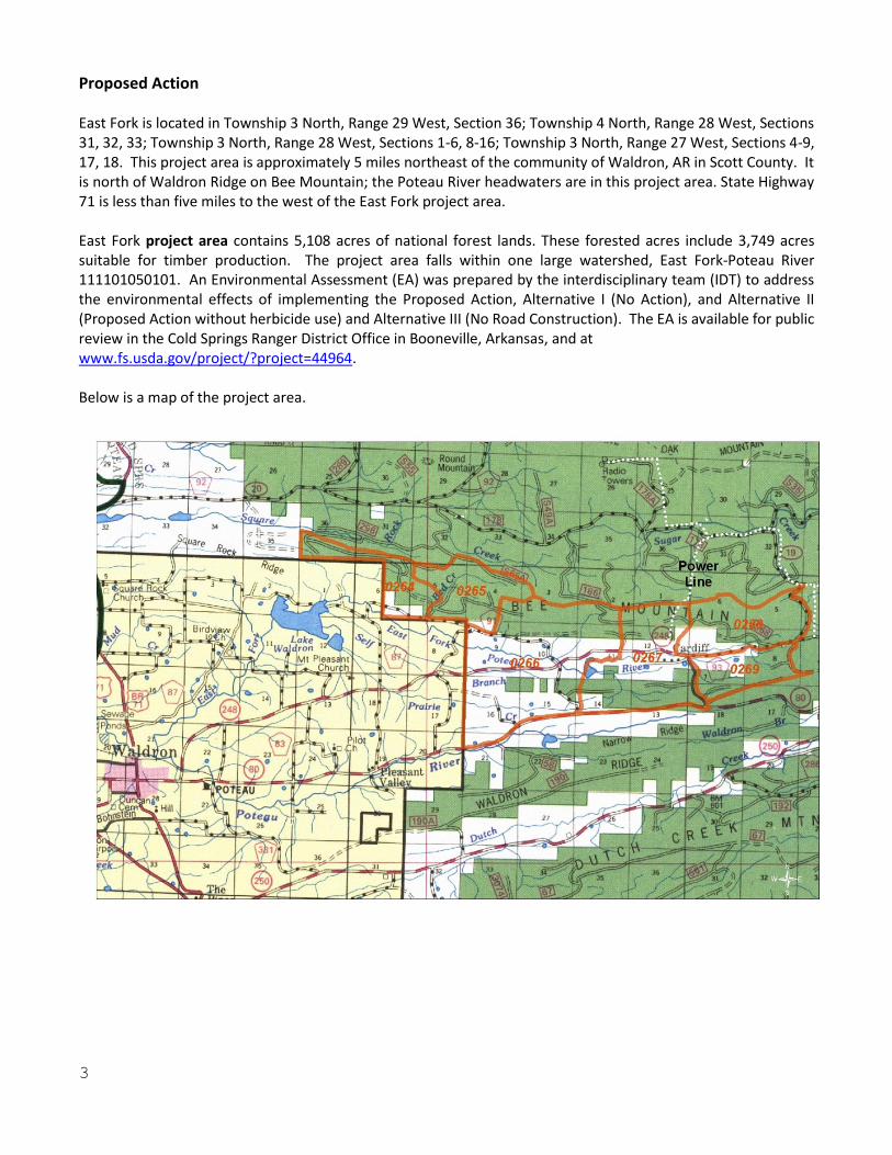
Proposed Action East Fork is located in Township 3 North, Range 29 West, Section 36; Township 4 North, Range 28 West, Sections 31, 32, 33; Township 3 North, Range 28 West, Sections 1-6, 8-16; Township 3 North, Range 27 West, Sections 4-9, 17, 18. This project area is approximately 5 miles northeast of the community of Waldron, AR in Scott County. It is north of Waldron Ridge on Bee Mountain; the Poteau River headwaters are in this project area. State Highway 71 is less than five miles to the west of the East Fork project area. East Fork project area contains 5,108 acres of national forest lands. These forested acres include 3,749 acres suitable for timber production. The project area falls within one large watershed, East Fork-Poteau River 111101050101. An Environmental Assessment (EA) was prepared by the interdisciplinary team (IDT) to address the environmental effects of implementing the Proposed Action, Alternative I (No Action), and Alternative II (Proposed Action without herbicide use) and Alternative III (No Road Construction). The EA is available for public review in the Cold Springs Ranger District Office in Booneville, Arkansas, and at www.fs.usda.gov/project/?project=44964. Below is a map of the project area.
4
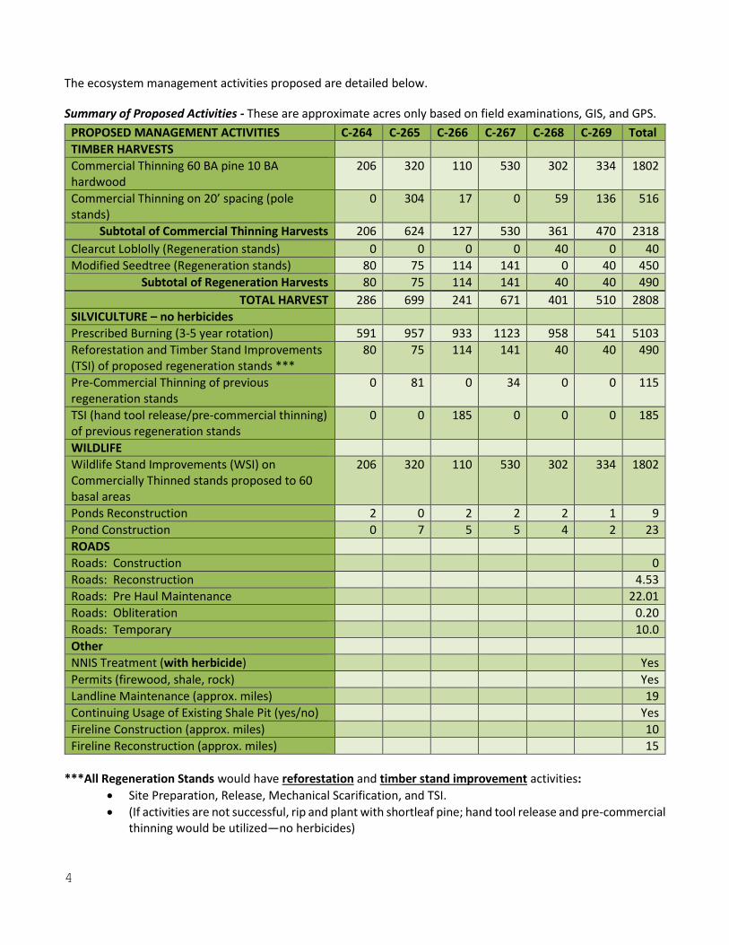
The ecosystem management activities proposed are detailed below.
Summary of Proposed Activities - These are approximate acres only based on field examinations, GIS, and GPS.
PROPOSED MANAGEMENT ACTIVITIES C-264 C-265 C-266 C-267 C-268 C-269 Total
TIMBER HARVESTS
Commercial Thinning 60 BA pine 10 BA hardwood
206 320 110 530 302 334 1802
Commercial Thinning on 20’ spacing (pole stands)
0 304 17 0 59 136 516
Subtotal of Commercial Thinning Harvests 206 624 127 530 361 470 2318
Clearcut Loblolly (Regeneration stands) 0 0 0 0 40 0 40
Modified Seedtree (Regeneration stands) 80 75 114 141 0 40 450
Subtotal of Regeneration Harvests 80 75 114 141 40 40 490
TOTAL HARVEST 286 699 241 671 401 510 2808
SILVICULTURE – no herbicides
Prescribed Burning (3-5 year rotation) 591 957 933 1123 958 541 5103
Reforestation and Timber Stand Improvements (TSI) of proposed regeneration stands ***
80 75 114 141 40 40 490
Pre-Commercial Thinning of previous regeneration stands
0 81 0 34 0 0 115
TSI (hand tool release/pre-commercial thinning) of previous regeneration stands
0 0 185 0 0 0 185
WILDLIFE
Wildlife Stand Improvements (WSI) on Commercially Thinned stands proposed to 60 basal areas
206 320 110 530 302 334 1802
Ponds Reconstruction 2 0 2 2 2 1 9
Pond Construction 0 7 5 5 4 2 23
ROADS
Roads: Construction 0
Roads: Reconstruction 4.53
Roads: Pre Haul Maintenance 22.01
Roads: Obliteration 0.20
Roads: Temporary 10.0
Other
NNIS Treatment (with herbicide) Yes
Permits (firewood, shale, rock) Yes
Landline Maintenance (approx. miles) 19
Continuing Usage of Existing Shale Pit (yes/no) Yes
Fireline Construction (approx. miles) 10
Fireline Reconstruction (approx. miles) 15
***All Regeneration Stands would have reforestation and timber stand improvement activities:
Site Preparation, Release, Mechanical Scarification, and TSI.
(If activities are not successful, rip and plant with shortleaf pine; hand tool release and pre-commercial thinning would be utilized—no herbicides)
5
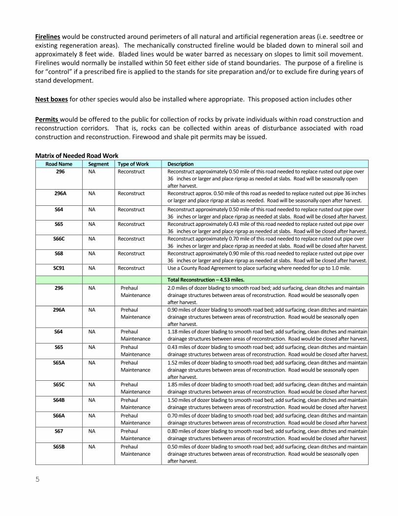
Firelines would be constructed around perimeters of all natural and artificial regeneration areas (i.e. seedtree or existing regeneration areas). The mechanically constructed fireline would be bladed down to mineral soil and approximately 8 feet wide. Bladed lines would be water barred as necessary on slopes to limit soil movement. Firelines would normally be installed within 50 feet either side of stand boundaries. The purpose of a fireline is for “control” if a prescribed fire is applied to the stands for site preparation and/or to exclude fire during years of stand development.
Nest boxes for other species would also be installed where appropriate. This proposed action includes other
Permits would be offered to the public for collection of rocks by private individuals within road construction and reconstruction corridors. That is, rocks can be collected within areas of disturbance associated with road construction and reconstruction. Firewood and shale pit permits may be issued.
Matrix of Needed Road Work Road Name Segment Type of Work Description
296 NA Reconstruct Reconstruct approximately 0.50 mile of this road needed to replace rusted out pipe over 36 inches or larger and place riprap as needed at slabs. Road will be seasonally open after harvest.
296A NA Reconstruct Reconstruct approx. 0.50 mile of this road as needed to replace rusted out pipe 36 inches or larger and place riprap at slab as needed. Road will be seasonally open after harvest.
S64 NA Reconstruct Reconstruct approximately 0.50 mile of this road needed to replace rusted out pipe over 36 inches or larger and place riprap as needed at slabs. Road will be closed after harvest.
S65 NA Reconstruct Reconstruct approximately 0.43 mile of this road needed to replace rusted out pipe over 36 inches or larger and place riprap as needed at slabs. Road will be closed after harvest.
S66C NA Reconstruct Reconstruct approximately 0.70 mile of this road needed to replace rusted out pipe over 36 inches or larger and place riprap as needed at slabs. Road will be closed after harvest.
S68 NA Reconstruct Reconstruct approximately 0.90 mile of this road needed to replace rusted out pipe over 36 inches or larger and place riprap as needed at slabs. Road will be closed after harvest.
SC91 NA Reconstruct Use a County Road Agreement to place surfacing where needed for up to 1.0 mile.
Total Reconstruction – 4.53 miles.
296 NA Prehaul Maintenance
2.0 miles of dozer blading to smooth road bed; add surfacing, clean ditches and maintain drainage structures between areas of reconstruction. Road would be seasonally open after harvest.
296A NA Prehaul Maintenance
0.90 miles of dozer blading to smooth road bed; add surfacing, clean ditches and maintain drainage structures between areas of reconstruction. Road would be seasonally open after harvest.
S64 NA Prehaul Maintenance
1.18 miles of dozer blading to smooth road bed; add surfacing, clean ditches and maintain drainage structures between areas of reconstruction. Road would be closed after harvest.
S65 NA Prehaul Maintenance
0.43 miles of dozer blading to smooth road bed; add surfacing, clean ditches and maintain drainage structures between areas of reconstruction. Road would be closed after harvest.
S65A NA Prehaul Maintenance
1.52 miles of dozer blading to smooth road bed; add surfacing, clean ditches and maintain drainage structures between areas of reconstruction. Road would be seasonally open after harvest.
S65C NA Prehaul Maintenance
1.85 miles of dozer blading to smooth road bed; add surfacing, clean ditches and maintain drainage structures between areas of reconstruction. Road would be closed after harvest
S64B NA Prehaul Maintenance
1.50 miles of dozer blading to smooth road bed; add surfacing, clean ditches and maintain drainage structures between areas of reconstruction. Road would be closed after harvest
S66A NA Prehaul Maintenance
0.70 miles of dozer blading to smooth road bed; add surfacing, clean ditches and maintain drainage structures between areas of reconstruction. Road would be closed after harvest
S67 NA Prehaul Maintenance
0.80 miles of dozer blading to smooth road bed; add surfacing, clean ditches and maintain drainage structures between areas of reconstruction. Road would be closed after harvest
S65B NA Prehaul Maintenance
0.50 miles of dozer blading to smooth road bed; add surfacing, clean ditches and maintain drainage structures between areas of reconstruction. Road would be seasonally open after harvest.
6
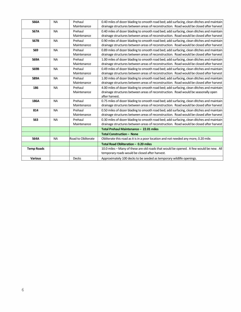
S66A NA Prehaul Maintenance
0.40 miles of dozer blading to smooth road bed; add surfacing, clean ditches and maintain drainage structures between areas of reconstruction. Road would be closed after harvest
S67A NA Prehaul Maintenance
0.40 miles of dozer blading to smooth road bed; add surfacing, clean ditches and maintain drainage structures between areas of reconstruction. Road would be closed after harvest
S67B NA Prehaul Maintenance
0.90 miles of dozer blading to smooth road bed; add surfacing, clean ditches and maintain drainage structures between areas of reconstruction. Road would be closed after harvest
S69 NA Prehaul Maintenance
0.89 miles of dozer blading to smooth road bed; add surfacing, clean ditches and maintain drainage structures between areas of reconstruction. Road would be closed after harvest
S69A NA Prehaul Maintenance
1.00 miles of dozer blading to smooth road bed; add surfacing, clean ditches and maintain drainage structures between areas of reconstruction. Road would be closed after harvest
S69B NA Prehaul Maintenance
0.49 miles of dozer blading to smooth road bed; add surfacing, clean ditches and maintain drainage structures between areas of reconstruction. Road would be closed after harvest
S89A NA Prehaul Maintenance
1.00 miles of dozer blading to smooth road bed; add surfacing, clean ditches and maintain drainage structures between areas of reconstruction. Road would be closed after harvest
186 NA Prehaul Maintenance
4.00 miles of dozer blading to smooth road bed; add surfacing, clean ditches and maintain drainage structures between areas of reconstruction. Road would be seasonally open after harvest.
186A NA Prehaul Maintenance
0.75 miles of dozer blading to smooth road bed; add surfacing, clean ditches and maintain drainage structures between areas of reconstruction. Road would be closed after harvest
814 NA Prehaul Maintenance
0.50 miles of dozer blading to smooth road bed; add surfacing, clean ditches and maintain drainage structures between areas of reconstruction. Road would be closed after harvest
S63 NA Prehaul Maintenance
0.30 miles of dozer blading to smooth road bed; add surfacing, clean ditches and maintain drainage structures between areas of reconstruction. Road would be closed after harvest
Total Prehaul Maintenance – 22.01 miles
Total Construction – None
S64A NA Road to Obliterate Obliterate this road as it is in a poor location and not needed any more, 0.20 mile.
Total Road Obliteration – 0.20 miles
Temp Roads 10.0 miles – Many of these are old roads that would be opened. A few would be new. All temporary roads would be closed after harvest.
Various Decks Approximately 100 decks to be seeded as temporary wildlife openings.
7
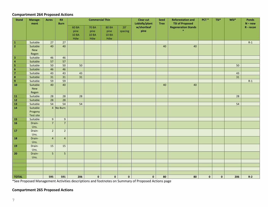
Compartment 264 Proposed Actions Stand Manage-
ment Acres RX
Burn Commercial Thin
Clear cut
Loblolly/plant w/shortleaf
pine
Seed Tree
Reforestation and TSI of Proposed
Regeneration Stands *
PCT * TSI* WSI* Ponds N – new R - recon 60 BA
pine 10 BA Hdw
70 BA pine
10 BA Hdw
80 BA pine
10 BA Hdw
20’ spacing
1 Suitable 27 27 R-1
2 Suitable New
Regen
40 40 40 40
3 Suitable 46 46
4 Suitable 57 57
5 Suitable 50 50 50 50
6 Suitable 46 46
7 Suitable 43 43 43 43
8 Suitable 31 31 31 31
9 Suitable 59 59 R-1
10 Suitable New
Regen
40 40 40 40
11 Suitable 28 28 28 28
12 Suitable 28 28
13 Suitable 54 54 54 54
14 Suitable Progeny Test site
4 No Burn
15 Suitable 9 9
16 Drain-Uns.
7 7
17 Drain-Uns.
2 2
18 Drain-Uns.
4 4
19 Drain-Uns.
15 15
20 Drain-Uns.
5 5
TOTAL 595 591 206 0 0 0 0 80 80 0 0 206 R-2
*See Proposed Management Activities descriptions and footnotes on Summary of Proposed Actions page
Compartment 265 Proposed Actions
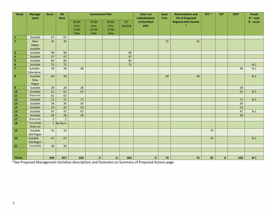
8
Stand Manage-ment
Acres RX Burn
Commercial Thin
Clear cut Loblolly/plant
w/shortleaf pine
Seed Tree
Reforestation and TSI of Proposed
Regeneration Stands *
PCT * TSI* WSI* Ponds N – new R - recon 60 BA
pine 10 BA Hdw
70 BA pine
10 BA Hdw
80 BA pine
10 BA Hdw
20’ spacing
1 Suitable 67 67
2 New Regen
Suitable
35 35 35 35
3 Suitable 98 98 98
4 Suitable 47 47 47
5 Suitable 84 84 84
6 Suitable 75 75 75 N-1
7 Suitable hdw>pine
38 38 38 38 N-1
8 Suitable New
Regen
40 40 40 40 N-1
9 Suitable 28 28 28 28
10 Suitable 51 51 51 51 N-1
11 Drain-Uns. 62 62
12 Suitable 71 71 71 71 N-1
13 Suitable 34 34 34 34
14 Suitable 23 23 23 23
15 Suitable 47 47 47 47 N-1
16 Suitable 28 28 28 28
17 Drain-Uns. 2 2
18 Unsuitable
Shale pit 1 No Burn
19 Suitable Old Regen
32 32 32
20 Suitable Old Regen
47 47 47 N-1
21 Unsuitable 48 48
TOTAL 958 957 320 0 0 304 0 75 75 81 0 320 N-7
*See Proposed Management Activities descriptions and footnotes on Summary of Proposed Actions page
9
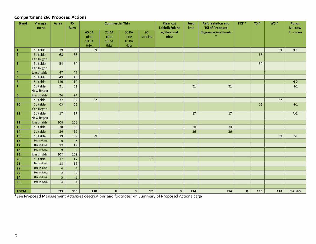
Compartment 266 Proposed Actions Stand Manage-
ment Acres RX
Burn Commercial Thin
Clear cut
Loblolly/plant w/shortleaf
pine
Seed Tree
Reforestation and TSI of Proposed
Regeneration Stands *
PCT * TSI* WSI* Ponds N – new R - recon 60 BA
pine 10 BA Hdw
70 BA pine
10 BA Hdw
80 BA pine
10 BA Hdw
20’ spacing
1 Suitable 39 39 39 39 N-1
2 Suitable Old Regen
68 68 68
3 Suitable Old Regen
54 54 54
4 Unsuitable 47 47
5 Suitable 49 49
6 Suitable 110 110 N-2
7 Suitable New Regen
31 31 31 31 N-1
8 Unsuitable 24 24
9 Suitable 32 32 32 32
10 Suitable Old Regen
63 63 63 N-1
11 Suitable New Regen
17 17 17 17 R-1
12 Unsuitable 108 108
13 Suitable 30 30 30 30
14 Suitable 36 36 36 36
15 Suitable 39 39 39 39 R-1
16 Drain-Uns. 6 6
17 Drain-Uns. 13 13
18 Drain-Uns. 9 9
19 Unsuitable 108 108
20 Suitable 17 17 17
21 Drain-Uns. 18 18
22 Drain-Uns. 4 4
23 Drain-Uns. 2 2
24 Drain-Uns. 5 5
25 Drain-Uns. 4 4
TOTAL 933 933 110 0 0 17 0 114 114 0 185 110 R-2 N-5
*See Proposed Management Activities descriptions and footnotes on Summary of Proposed Actions page
10
Compartment 267 Proposed Actions Stand Manage-
ment Acres RX
Burn Commercial Thin
Clear cut
Loblolly/plant w/shortleaf
pine
Seed Tree
Reforestation and TSI of Proposed
Regeneration Stands *
PCT * TSI* WSI* Ponds N – new R - recon 60 BA
pine 10 BA Hdw
70 BA pine
10 BA Hdw
80 BA pine
10 BA Hdw
20’ spacing
1 Suitable 54 54 54 54
2 Suitable 52 52 52 52
3 Drain-Uns. 3 3
4 Unsuitable 83 83
5 Unsuitable 35 35
6 Suitable 42 42 R-1
7 Suitable 34 34 34 34 N-1
8 Suitable 67 67 R-1
9 Unsuitable 63 63
10 Unsuitable 13 13
11 Drain-Uns. 11 11
12 Suitable New Regen
33 33 33 33
13 Suitable 77 77 77 77 N-1
14 Suitable 52 52 52 52
15 Suitable 95 95 95 95
16 Suitable New Regen
35 35 35 35
17 Suitable 88 88 88 88
18 Suitable New Regen
40 40 40 40
19 Suitable 53 53 53 53 N-1
20 Drain-Uns. 37 37
21 Suitable 35 35 N-1
22 Old Regen 34 34 34
23 Suitable New Regen
33 33 33 33
24 Suitable 25 25 25 25 N-1
25 Drain-Uns. 6 6
26 Drain-Uns. 8 8
27 Drain-Uns. 2 2
28 Drain-Uns. 2 2
29 Drain-Uns. 4 4
30 Drain-Uns. 3 3
31 Drain-Uns. 2 2
32 Unsuitable 2 2
TOTAL 1123 1123 530 0 0 0 0 141 141 34 0 530 R-2 N-5
*See Proposed Management Activities descriptions and footnotes on Summary of Proposed Actions page
Compartment 268 Proposed Actions
11
Stand Manage-ment
Acres RX Burn
Commercial Thin
Clear cut Loblolly/plant
w/shortleaf pine
Seed Tree
Reforestation and TSI of Proposed
Regeneration Stands *
PCT * TSI* WSI* Ponds N – new R - recon 60 BA
pine 10 BA Hdw
70 BA pine
10 BA Hdw
80 BA pine
10 BA Hdw
20’ spacing
1 Suitable 68 68 68 68
2 Suitable Regen takes loblolly from drains
14 14 14 14
3 Suitable 42 42 42 42 N-1
4 Suitable 61 61 61 61
5 Suitable 51 51 51 51 N-1
6 Unsuitable 330 330 N-1
7 Suitable 52 52 52 52
8 Suitable 5 5
9 Suitable 38 38
10 Suitable New Regen
25 25
11 Suitable 22 22
12 Unsuitable 18 18
13 Suitable 13 13 13
14 Suitable 46 46 46 R-1
15 Suitable 30 30
16 Suitable Regen/loblolly
4 4 4 4
17 Suitable Regen/loblolly
9 9 9 9
18 Suitable Regen/loblolly
13 13 13 13 R-1
19 Suitable 28 28 28 28 N-1
20 Suitable 16 16
21 Drain-Uns. 5 5
22 Drain-Uns. 2 2
23 Drain-Uns. 12 12
24 Drain-Uns. 2 2
25 Drain-Uns. 4 4
26 Drain-Uns. 9 9
27 Drain-Uns. 23 23
28 Drain-Uns. 9 9
29 Drain-Uns. 2 2
30 Drain-Uns. 5 5
TOTAL 958 958 302 0 0 59 40 0 40 0 0 302 R-2 N-4
*See Proposed Management Activities descriptions and footnotes on Summary of Proposed Actions page
12
Compartment 269 Proposed Actions Stand Manage-
ment Acres RX
Burn Commercial Thin
Clear cut
Loblolly/plant w/shortleaf
pine
Seed Tree
Reforestation and TSI of Proposed
Regeneration Stands *
PCT * TSI* WSI* Ponds N – new R - recon 60 BA
pine 10 BA Hdw
70 BA pine
10 BA Hdw
80 BA pine
10 BA Hdw
20’ spacing
1 Suitable New
Regen
40 40 40 40
2 Suitable 64 64 64 64
3 Suitable 90 90 90 90
4 Suitable 71 71 71 N-1
5 Suitable 54 54 54 54 N-1
6 Suitable 65 65 65 R-1
7 Suitable 83 83 83 83
8 Drain-Uns.
5 5
9 Drain-Uns.
9 9
10 Drain-Uns.
15 15
11 Suitable 17 17 17 17
12 Drain-Uns.
2 2
13 Suitable 26 26 26 26
TOTAL 541 541 334 0 0 136 0 40 40 0 0 334 R-1 N-2
*See Proposed Management Activities descriptions and footnotes on Summary of Proposed Actions page
13
Decision Based on the analysis documented in the EA, it is my decision to implement the Proposed Action identified above for the East Fork Ecosystem Management Unit. My decision is based on a review of the record that shows a thorough review of relevant scientific information, a consideration of responsible opposing views, and the acknowledgement of incomplete or unavailable information. See Relevant Planning Documents (EA Chapter 1 p. 12), Technical Requirements and Forest Plan Mitigations (EA Chapter 2 p. 16), and Literature Cited (EA Chapter 6 p. 92).
Reasons for the Decision 1. The Proposed Action was chosen over Alternative I (No Action) because the No Action Alternative would
not meet the identified purpose and need for this project as stated in the EA beginning on page 8. 2. The Proposed Action was chosen over Alternative II (Proposed Action without herbicide use) because
herbicide is an effective treatment for the control of non-native invasive species. 3. The Proposed Action was chosen over Alternative III (No Road Construction) because it will create more
early seral habitat, remove an off-site species (loblolly), increase the wildlife water sources by 40%, provide for more development of forbs and grass on the landscape, and improve the resiliency and vigor of residual stands on a larger area of the forest.
Specifically, the Proposed Action would best meet the following project objectives (EA, p. 19):
To create a healthy forest condition.
To create early seral stage habitat (even-age only).
To remove off-site species (loblolly).
To reduce competing vegetation for nutrients, water, and sun.
To site prep a bed for seed fall after the regeneration harvests.
To provide new growth for wildlife to eat.
To reduce heavily stocked understories and midstories primarily due to lack of fire as part of the ecosystem.
To reduce fuel loading.
To create a suitable seedbed in regeneration sites after initial prescribed burning.
To increase growth rate and quality of desired trees by reducing competition for nutrients and water among species.
To ensure survival of desired trees by releasing suppressed trees from competing tree species.
To create water sources for wildlife.
To reduce midstory and allow development of grasses and forbs on the forest floor.
To move toward the open road density objective.
To access harvest units and provide safe road system.
To repair or maintain road surfaces, ditch erosion, and repair or replace rusted-out pipes.
To provide short-term access to harvest units.
To reduce the impacts to streams and get rid of roads not needed in the future.
To supply firewood areas to the local community.
To supply rock permits to the local community.
To stop or slow the infestation of invasive and non-native species such as mimosa, lespedeza, privet, or any other species of these types encountered within this analysis area.
To ensure landlines are maintained.
14
Role of the Interdisciplinary Team and Public Involvement Public involvement began March 16, 2015. A detailed description of the Proposed Actions along with existing and desired conditions was mailed hardcopy to 5 individuals through the postal service and emailed to 29 individuals; 1 through direct email and 27 through GovDelivery to those who have shown interest on the project’s webpage www.fs.usda.gov/project/?project=44964. Comments were received from this public involvement from Bradley Jones, Arkansas Department of Health (wants to be notified when herbicides are used); Jim Parma, East Fiber Manager with Bell Timber (wants use of all forest products); John Fox with Osage Tribe (clarifications); and Dick Artley (herbicide use and road construction concerns; wants to be notified concerning project). The 30-day comment period began 6/18/15. One response was received from Dick Artley.
Issues Identified Issue #1: Herbicide use is considered an “issue to be analyzed in depth” because of the intensity of interest that will require the formulation of a “non-herbicide” alternative. Herbicide use is proposed to achieve the desired conditions to establish native forest cover where needed. This would be to remove nonnative species such as mimosa or privet. Issue #2: Road construction is considered an “issue to be analyzed in depth” because of the intensity of interest that will require the formulation of a “no road construction” alternative. Road construction is proposed to access forest stands proposed for harvest.
Alternatives Eliminated From Detailed Study There were no issues or unresolved conflicts to drive the following additional alternatives, but the interdisciplinary team considered the following:
No Harvest Alternative This alternative was considered by the Interdisciplinary Team but eliminated from detailed analysis because the Team felt the No Action Alternative adequately addressed the overall effects of a no harvest alternative.
Alternatives Considered in Detail Four alternatives were analyzed in the EA:
1. Proposed Action (Preferred Alternative) – This alternative is described on pages 4-12 of this document. (Also, see EA, pp. 20 and Appendix C).
2. Alternative I (No Action) - Under the No Action Alternative neither the Proposed Action nor any other action alternative would be implemented. (See EA, p. 21). Management activities would be deferred until a later entry. However, ongoing Forest Service approved activities would continue in the project area.
3. Alternative II (Proposed Action without herbicide use)- This alternative is the same as the Proposed Action except for herbicides are not proposed treatment of non-native invasive plant species (See EA, p. 21).
4. Alternative III (No New Roads)- Under this alternative, there would be no road construction (temporary or system); only proposed timber harvest (and dependent management actions) accessible by the current transportation system would occur (See EA, p. 22 and Appendix D).
15
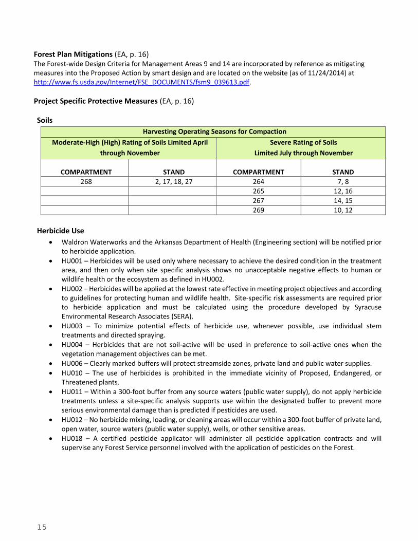
Forest Plan Mitigations (EA, p. 16) The Forest-wide Design Criteria for Management Areas 9 and 14 are incorporated by reference as mitigating measures into the Proposed Action by smart design and are located on the website (as of 11/24/2014) at http://www.fs.usda.gov/Internet/FSE_DOCUMENTS/fsm9_039613.pdf.
Project Specific Protective Measures (EA, p. 16)
Soils
Harvesting Operating Seasons for Compaction
Moderate-High (High) Rating of Soils Limited April
through November
Severe Rating of Soils
Limited July through November
COMPARTMENT STAND COMPARTMENT STAND
268 2, 17, 18, 27 264 7, 8
265 12, 16
267 14, 15
269 10, 12
Herbicide Use
Waldron Waterworks and the Arkansas Department of Health (Engineering section) will be notified prior to herbicide application.
HU001 – Herbicides will be used only where necessary to achieve the desired condition in the treatment area, and then only when site specific analysis shows no unacceptable negative effects to human or wildlife health or the ecosystem as defined in HU002.
HU002 – Herbicides will be applied at the lowest rate effective in meeting project objectives and according to guidelines for protecting human and wildlife health. Site-specific risk assessments are required prior to herbicide application and must be calculated using the procedure developed by Syracuse Environmental Research Associates (SERA).
HU003 – To minimize potential effects of herbicide use, whenever possible, use individual stem treatments and directed spraying.
HU004 – Herbicides that are not soil-active will be used in preference to soil-active ones when the vegetation management objectives can be met.
HU006 – Clearly marked buffers will protect streamside zones, private land and public water supplies.
HU010 – The use of herbicides is prohibited in the immediate vicinity of Proposed, Endangered, or Threatened plants.
HU011 – Within a 300-foot buffer from any source waters (public water supply), do not apply herbicide treatments unless a site-specific analysis supports use within the designated buffer to prevent more serious environmental damage than is predicted if pesticides are used.
HU012 – No herbicide mixing, loading, or cleaning areas will occur within a 300-foot buffer of private land, open water, source waters (public water supply), wells, or other sensitive areas.
HU018 – A certified pesticide applicator will administer all pesticide application contracts and will supervise any Forest Service personnel involved with the application of pesticides on the Forest.

16
Heritage The following measures only apply to cultural resource sites that are unevaluated, eligible for listing, or listed in the National Register of Historic Places.
HP1: Site Avoidance During Project Implementation Avoidance of historic properties (HP) will require the protection from effects resulting from the undertaking. Effects will be avoided by (1) establishing clearly defined site boundaries and buffers around archeological sites where activities that might result in an adverse effect. Buffers will be of sufficient size to ensure that integrity of the characteristics and values which contribute to, or potentially contribute to, the properties' significance will not be affected, and (2) routing proposed new roads, temporary roads, log landings and skid trails away from historic properties;
HP2: Site Protection During Prescribed Burns
Firelines. Historic properties located along existing non-maintained woods roads used as fire lines will be protected by hand-clearing those sections that cross the sites. Although these roads are generally cleared of combustible debris using a small dozer, those sections crossing archeological sites will be cleared using leaf blowers and/or leaf rakes. There will be neither removal of soil, nor disturbance below the ground surface, during fireline preparation. Historic properties and features located along proposed routes of mechanically-constructed firelines, where firelines do not now exist, will be avoided by routing fireline construction around historic properties. Sites that lie along previously constructed dozer lines from past burns where the firelines will be used again as firelines, will be protected during future burns by hand clearing sections of line that cross the site, rather than re-clearing using heavy equipment. Where these activities will take place outside stands not already surveyed, cultural resources surveys and regulatory consultation will be completed prior to project implementation. Protection measures, HP1, HP3, and HP4, will be applied prior to project implementation to protect historic properties.
Burn Unit Interior. Combustible elements at historic properties in burn unit interiors will be protected from damage during burns by removing excessive fuels from the feature vicinity and, as necessary, by burning out around the feature prior to igniting the main burn, creating a fuel-free zone. Burn out is accomplished by constructing a set of two hand lines around the feature, approximately 30 to 50 feet. apart, and then burning the area between the two lines while the burn is carefully monitored. Combustible features located in a burn unit will also be documented with digital photographs and/or field drawings prior to the burn. Historic properties containing above ground, non-combustible cultural features and exposed artifacts will be protected by removing fuel concentrations dense enough to significantly alter the characteristics of those cultural resources. No additional measures are proposed for any sites in the burn interior that have been previously burned or that do not contain combustible elements or other above ground features and exposed artifacts as proposed prescribed burns will not be sufficiently intense to cause adverse effects to these features.
Post-Burn Monitoring. Post-burn monitoring may be conducted at selected sites to assess actual and indirect effects of the burns on the sites against the expected effects. SHPO consultation will be carried out with respect to necessary mitigation for any sites that suffer unexpected damage during the burn or from indirect effects following the burn.
HP3: Other Protection Measures If it is not feasible or desirable to avoid an historic property that may be harmed by a project activity (HP1), then the following steps will be taken: (1) In consultation with the Arkansas SHPO, the site(s) will be evaluated against NRHP significance criteria (36 CFR 60.4) to determine eligibility for the NRHP. The evaluation may require subsurface site testing; (2) In consultation with the Arkansas SHPO, tribes and nations, and with the ACHP if required, mitigation measures will be developed to minimize the adverse effects on the site, so that a finding of
17
No Adverse Effect results; (3) The agreed-upon mitigation measures will be implemented prior to initiation of activities having the potential to affect the site.
HP4: Discovery of Cultural Resources during Project Implementation Although cultural resources surveys were designed to locate all NRHP eligible archeological sites and components, these may go undetected for a variety of reasons. Should unrecorded cultural resources be discovered, activities that may be affecting that resource will halt immediately; the resource will be evaluated by an archaeologist, and consultation will be initiated with the SHPO, tribes and nations, and the ACHP, to determine appropriate actions for protecting the resource and mitigating adverse effects. Project activities at that locale will not resume until the resource is adequately protected and until agreed-upon mitigation measures are implemented with SHPO approval.
Monitoring The Revised Forest Plan lists monitoring activities for the Ouachita National Forest. The Forest’s monitoring program is designed to evaluate the environmental effects of actions similar to those proposed in this project, and also serves to assess the effectiveness of treatments. In order to ensure that the appropriate design criteria protecting soil stability, water quality, and other resources are followed, trained contract administrators and inspectors would be on-site during the implementation phase of the project. For those activities that include the use of herbicides, surveillance monitoring to ensure that herbicide label instructions are being followed would be conducted as part of the contract administration. Form R8-FS-2100-1, Herbicide Treatment and Evaluation Record, would be used to monitor work involving herbicides. Stream samples would also be taken to monitor for offsite movement. East Fork would be monitored before and after the Proposed Actions including timber harvesting, reforestation, and wildlife activities. A pre-sale stream survey was completed on 7/12/13 on Poteau River East by Natural Resources Manager Charity Jade Ryles, Arkansas State University Wildlife Doctoral Candidate Bob Vernocy, and Research Assistant Neil Gleason. Location was at Cardiff Highway 248 and SC93 on private land near National Forest Service land boundary and FS Road 19.
18
Finding of No Significant Impact (FONSI) I have determined that the proposed actions are not a major federal action, either individually or cumulatively, and will not significantly affect the quality of the human environment based on the EA and from past experience with similar forest management activities. Therefore, an environmental impact statement is not necessary. This determination is based upon the following factors:
1. Both beneficial and adverse effects have been considered and this action will not have a significant effect
on the quality of the human environment (EA, Chapter 3 Environmental Disclosures). 2. The degree to which public health and safety may be affected is minimal (EA, pp. 81). 3. The project will not affect any unique characteristics of the geographic area (historic or cultural resource,
wetlands, and floodplains, etc.). This is based on information gathered through records and site specific field inventories (EA, p.13, 34, 36, and 87).
4. Based on public involvement and the analyses conducted in the EA, the effects on the quality of the human environment are not likely to be highly controversial (EA, p.12 and Chapter 3 Environmental Disclosures).
5. The actions do not involve highly uncertain, unique, or unknown environmental risks to the human environment. All actions described have been conducted before, and district staff members have considerable expertise in carrying out these actions (EA, Chapter 3 Environmental Disclosures).
6. The actions in this decision will not establish a precedent for future actions with significant effects nor does it represent a decision in principle about a future consideration (EA, Chapter 3 Environmental Disclosures).
7. The cumulative effects of the proposed actions have been analyzed with consideration for past and foreseeable future activities on adjacent public and private land, and no significant cumulative effects would result from implementation (EA, p. 23) and Chapter 3 Environmental Disclosures).
8. The actions will not affect any sites listed in or eligible for listing in the National Register of Historic Places nor will they cause loss or destruction of significant scientific, cultural or historic resources. This is based on site specific cultural resource surveys conducted on the analysis area, preparation of a Cultural Resources Report, and consultation on the proposed project with the Arkansas State Historic Preservation Officer. (EA, pp. 14, 17, 87).
9. The actions are not likely to significantly affect endangered or threatened plant or animal species or critical habitat under the Endangered Species Act (EA, pp. 52-75 and Biological Evaluation).
10. None of the actions threaten to lead to violation of federal, state, or local laws imposed for the protection of the environment. This will be ensured by carrying out the decision in a way that is consistent with the forest-wide design criteria, management requirements and mitigation measures established in the Revised Forest Plan. For water quality management, State approved Best Management Practices will be used for this project. The project will be monitored to ensure BMPs are implemented. If implementing BMPs on a specific site results in effects significantly higher than anticipated, because of unforeseen site factors or events, appropriate corrective measures will be considered and implemented. This project will fully comply with State approved BMPs and the Clean Water Act (EA, pp. 36-39).
Findings Required by Other Laws and Regulations I have determined that actions included in this decision are consistent with the Revised Forest Land and Resource Management Plan for the Ouachita National Forest because the selected alternative has been planned and will be implemented in accordance with all applicable design criteria of the Revised Forest Plan (EA, p. 16). The actions described in the selected alternative are typical of those projected for implementation in the Revised Land and Resource Management Plan and for which the environmental effects are disclosed in the Final Supplement to the Environmental Impact Statement (FEIS). This environmental assessment tiers to the FEIS (EA, p. 16).
19
National Forest Management Act (NFMA) Under 16 U.S.C. 1604 (g)(3)(E), a Responsible Official may authorize site-specific projects and activities on NFS lands to harvest timber only where:
1. Soil, slope, or other watershed conditions will not be irreversibly damaged (EA, p. 32-59). 2. There is assurance that the lands can be adequately restocked within five years after final
regeneration harvest; hand-planting will occur if natural regeneration is inadequate (EA, p. 47-51, 99). 3. Protection is provided for streams, streambanks, shorelines, lakes, wetlands, and other bodies of
water from detrimental changes in water temperatures, blockages of water courses, and deposits of sediment where harvests are likely to seriously and adversely affect water conditions or fish habitat; protection is provided by adherence to minimum widths of streamside management areas (SMAs), protected areas adjacent to bodies of water and on each side of perennial streams and other streams with defined channels (Revised Forest Plan, pp. 103-104).
4. The harvesting system to be used is not selected primarily because it will give the greatest dollar return or the greatest unit output of timber. See EA, Purpose & Need, pp. 8-12; EA, Appendix B.
A Responsible Official may authorize site-specific projects and activities on NFS lands using clearcutting, seed tree cutting, shelterwood cutting, and other cuts designed to regenerate an even-aged stand of timber as a cutting method only where:
1. For clearcutting, it is determined to be the optimum method; for other cutting methods it is determined to be appropriate and meets the objectives and requirements of the applicable land management plan (16 U.S.C. 1604 (g)(3)(F)(i)). See EA, Purpose & Need, pp. 8-12; EA, Appendix B.
2. The interdisciplinary review has been completed and the potential environmental, biological, aesthetic, engineering, and economic impacts on each advertised sale area have been assessed, as well as the consistency of the sale with the multiple use of the general area (16 U.S.C. 1604 (g)(3)(F)(ii)). See EA, Chapter 3 and pg. 91.
3. Cut blocks, patches, or strips are shaped and blended to the extent practicable with the natural terrain (16 U.S.C. 1604 (g)(3)(F)(iii)). The Scenery Treatment Guide-Southern Region National Forests will be followed (EA, p. 85).
4. These cuts are carried out according to the maximum size limits for areas to be cut in one harvest operation as required by 16 U.S.C. 1604 (g)(3)(F)(iv)). Cuts are carried out according to the maximum size of regeneration area for even-aged management under Design Criteria FR009 (Revised Forest Plan, p. 81).
5. Timber cuts are carried out in a manner consistent with the protection of soil, watershed, fish, wildlife, recreation, and esthetic resources, and the regeneration of the timber resource (16 U.S.C. 1604 (g)(3)(F)(v)). See EA, Chapters 2 & 3.
6. Under 16 U.S.C. 1604 (m) even-aged stands of trees scheduled for regeneration harvest generally have reached culmination of mean annual increment of growth, unless the purpose of the timber cutting is excepted in the land management plan. Regeneration harvests are in compliance with Design Criteria FR009, Harvest Age (Revised Forest Plan page 81).

20
OBJECTION OPPORTUNITIES
This decision is subject to objection pursuant to 36 CFR 218 and must meet all of the requirements of 36 CFR 218.8. A written objection, including attachments, must be postmarked or received within 45 days after the date that notice of this draft decision is published in the Arkansas Democrat Gazette. Electronic objections in common formats (.doc, .rtf, .pdf, or .txt) may be submitted to: [email protected] with Subject: East Fork Project. Objections may also be faxed to (501) 321-5334 to the attention of “OBJECTION: East Fork Project,” sent by mail to:
Forest Supervisor ATTN: Objections
P.O. Box 1270 Hot Springs, AR 71902
Or hand-delivered during normal business hours of 8 a.m. to 4:30 p.m., Monday through Friday, excluding holidays at:
Ouachita National Forest Supervisor’s Office Federal Building, 2nd Floor
100 Reserve Street Hot Springs, AR
If an objection is received, notice of an objection resolution meeting open to the public will be posted on the Ouachita National Forest website.
IMPLEMENTATION DATE
As per 36 CFR 218.12, if no objection is received within the legal objection period, this decision may be signed and implemented on, but not before, the fifth business day following the close of the objection filing period. If an objection is filed, this decision cannot be signed or implemented until the reviewing officer has responded in writing to all pending objections.
Contact For further information on this decision, contact Donna Reagan, Cold Springs Ranger District, PO Box 417, Booneville, AR 72927; phone (479) 675-4743 ext. 107; email [email protected]. Responsible Official
DRAFT DN – Signature Pending – DRAFT DN
Date Pending Completion of Objection Review Process
District Ranger AJ Brigance DATE