Embed Size (px)
Citation preview
VOL. 5, NO. 2, DECEMBER 2016 ISSN 2305-493X
ARPN Journal of Earth Sciences ©2006-2016 Asian Research Publishing Network (ARPN). All rights reserved.
www.arpnjournals.com
75
EARTHQUAKE RISKS IN BANGLADESH: CAUSES, VULNERABILITY, PREPAREDNESS AND STRATEGIES FOR MITIGATION
Raihanul Islam1, Md. Nazrul Islam2 and M. Nazrul Islam2
1Central Women’s University, 6, Hatkhola Road, Dhaka, Bangladesh 2Department of Geography and Environment, Jahangirnagar University, Savar, Dhaka, Bangladesh
E-Mail: [email protected]
ABSTRACT
Bangladesh is facing a high risk of moderate to strong earthquakes that may result in widespread damage and loss of thousands of lives also the risk of tsunami as four active sources of earthquake in the Bay of Bengal can generate tremors with a magnitude of over 7 on the Richter scale in the Bay affecting the country seriously. Bangladesh is ill prepared to tackle the aftermath of any strong earthquake. Five geological fault lines run through the country, exposing it to highly vulnerable of a major quake by the experts. If a massive earthquake with 7 or greater magnitude occurred in this country will led a major human tragedy due to the faulty structures of many buildings and proper awareness. Thus, the study has been taken to promote efficient knowledge of the major causes, emerging risks, vulnerable zones, proper preparedness, impacts and approaches of mitigate impacts of earthquake in Bangladesh perspective. Keywords: earthquake, plate tectonics, preparedness, vulnerability, mitigation
INTRODUCTION
Bangladesh is positioned at the juncture of several active tectonic plate boundaries. Moreover, it sits a top of the world’s largest river delta at close to sea level, facing both the risk posed by a quake and secondary risks of tsunamis and flooding in the quake’s aftermath (Seeber, 2012). Tectonic framework of Bangladesh and adjoining areas indicate that Bangladesh is suited adjacent to the plate margins of India and Eurasia where devastating earthquakes have occurred in the past. Bangladesh is surrounded by a number of tectonic blocks which have produced earthquakes in recent times. The present generation of people in Bangladesh hasn't witnessed any major earthquake. As a result the population has been generally complacent about the risk of earthquakes. During the last seven or eight years, the occurrence and damage caused by some earthquakes (magnitude between 4 and 6) inside the country or near the country's border, has raised the awareness among the general people and the government as well. However, occurrences of earthquakes both inside and outside of the country and around major cities indicate that earthquake hazard exists for the country in general and the cities in particular. Consideration of earthquake forces in structural design, city planning and infrastructure development is therefore a prerequisite for future disaster mitigation (American Museum of Natural History, 2015).Geographically Bangladesh is located close to the two subduction zones created by two active tectonic plates: the Indian plate and the Eurasian plate. Moreover, the country is surrounded by the Himalayan Arc, the Shillong Plateau and the Dauki fault system in the north, the Burmese Arc and Arakan Yoma Anticlinorium in the east, and the Naga Disang Haflong thrust zone in the northeast (Ali and Choudhury, 2001). The capital city is vulnerable to the earthquake as the country is in an active region in terms of vertical and horizontal movement of
tremor. The existence of an active fault has been proved in Haluaghat of Mymenshingh recently, adding further risk to the vulnerability (Saha, M.K. 2011). Based on the record of the Geological Survey of Bangladesh, the country has experienced at least 465 earthquakes of minor-to-moderate magnitudes between 1971 and 2006. The actual number of earthquakes is considered to be many more than this, because many tremors are not been recorded due to a lack of proper seismic equipment in the lone operational observatory in Chittagong. Seismic experts consider recent repeated earthquakes of low to medium magnitude as an advance warning for a massive, and potentially disastrous earthquake in the near future, as these tremors fail to release the majority of the stress that accumulates within fault rupture zones (Bolt, 2005). Seismic experts also suspect that if an earthquake with a magnitude 7.0 on the Richter scale occurs in large cities of Bangladesh, there would be a major human tragedy and economic disaster due to the structural failure of many buildings built in these urban centers without the use of proper construction materials and in violation of building codes. Although the Bangladeshi government has developed building codes, which include detailed guidelines for earthquake resistant design of concrete and steel structures, these codes are not officially enforced. In the absence of an effective enforcement mechanism, it is widely believed that many new buildings do not have adequate provision for seismic resistance. As a consequence, the number of people living or working in unsafe structures in Dhaka is increasing (Paul, B.K., 2010). A major earthquake can destroy any town. It could bring a greatest devastation to a huge city, where millions of people live in poorly made buildings and also threatened by natural hazards like flooding and rising sea levels. These are the dangers that also fitted for Dhaka, the capital of Bangladesh. Scientists predict a major
VOL. 5, NO. 2, DECEMBER 2016 ISSN 2305-493X
ARPN Journal of Earth Sciences ©2006-2016 Asian Research Publishing Network (ARPN). All rights reserved.
www.arpnjournals.com
76
earthquake in the region. It’s been more than 100 years since the last one so Dhaka is not prepared. Although Bangladesh is extremely vulnerable to seismic activity, the nature and the level of this activity is yet to be defined. In Bangladesh complete earthquake monitoring facilities are not available. The Meteorological Department of Bangladesh established a seismic observatory at Chittagong in 1954. This remains the only observatory in the country. Status of earthquakes in Bangladesh is surrounded by the regions of high seismicity which include the Himalayan Arc and Shillong Plateau in the north, the Burmese Arc, Arakan Yoma Anticlinorium in the east and complex Naga-Disang-Jaflong thrust zones in the northeast. It is also the site of the Dauki Fault system along with numerous subsurface active faults and a flexure zone called Hinge Zone. These weak regions are believed to provide the necessary zones for movements within the basin area. In the generalized tectonic map of Bangladesh the distribution of epicenters is found to be linear along the Dauki Fault system and random in other regions of Bangladesh. The investigation of the map demonstrates that the epicenters are lying in the weak zones comprising surface or subsurface faults. Most of the events are of moderate rank (magnitude 4-6) and lie at a shallow depth, which suggests that the recent movements occurred in the sediments overlying the basement rocks. In the northeastern region (Surma Basin), major events are controlled by the Dauki Fault system. The events located in and around the Madhupur Track also indicate shallow displacement in the faults separating the block from the alluvium.
The first seismic zoning map of the subcontinent was compiled by the Geological Survey of India in 1935. The Bangladesh Meteorological Department adopted a seismic zoning map in 1972. In 1977, the Government of Bangladesh constituted a Committee of Experts to examine the seismic problem and make appropriate recommendations. The Committee proposed a zoning map of Bangladesh in the same year.In the zoning map, Bangladesh has been divided into three generalized seismic zones: zone-I, zone-II and zone-III. Zone-I comprising the northern and eastern regions of Bangladesh with the presence of the Dauki Fault system of eastern Sylhet and the deep seated Sylhet Fault, and proximity to the highly disturbed southeastern Assam region with the Jaflong thrust, Naga thrust and Disang thrust, is a zone of high seismic risk with a basic seismic co-efficient of 0.08. Northern Bangladesh comprising greater Rangpur and Dinajpur districts is also a region of high seismicity because of the presence of the Jamuna Fault and the proximity to the active east-west running fault and the Main Boundary Fault to the north in India. The Chittagong-Tripura Folded Belt experiences frequent earthquakes, as just to its east is the Burmese Arc where a large number of shallow depth earthquakes originate. Zone-II comprising the central part of Bangladesh represents the regions of recent uplifted Pleistocene blocks of the Barind and Madhupur Tracts, and the western extension of the folded belt. The Zone-III comprising the
southwestern part of Bangladesh is seismically quiet, with an estimated basic seismic co-efficient of 0.04 (Banglapedia, 2015). There are a number of researches carried out on earthquake. There are mentioned some such types of literature which is related to this topic. Akhtar (2010), in his study he focuses the vulnerability and risk mitigation of Dhaka city. Dhaka, a fast growing and densely populated (12.8 million as of 2008) mega city, poses an extremely high risk because of its population density (45, 508 per km2) and innumerable high-rise apartments. Kumar (2010), in his study of possible disastrous earthquake in Bangladesh and its Precautions have presented the various important aspects of earthquake and its threats, risks, vulnerability, preparations, precautions and rescue tasks with special vulnerability information on Rural Electrification (RE) Program in Bangladesh. Hossain (1998), reveals much information in the fields of tectonics, earthquake, occurrence, ground motion attenuation etc are to be added continuously to the existing database for updating the seismic zoning map in the future. He also said that northeastern cities of Bangladesh are more vulnerable to earthquake hazards than the central, eastern, southern and western cities. The most vulnerable cities in the northeast are Mymensingh, Kishorgonj and Sylhet. Finally he gave some mitigation measures in order to reduce the existing problems for earthquake in Bangladesh. Choudhury (1993) explained that earthquake is discussed geography and geology of Bangladesh. He showed the major earthquakes that affecting Bangladesh and different natural disasters that occurred in Bangladesh in different times. In his research he showed different maps which indicate seismic zone, seism tectonic, isoseismics etc. An outline of a code for earthquake resistant design was also prepared. A multidisciplinary research-based group said the CDMP survey made significant progress with a successful fault line search aided by modern technology and foreign experts. In course of the survey conducted from February 2008 to August 2009, a database of all the buildings and maps of roads, electricity, water and gas pipe lines were developed to assess possible damages that could occur during an earthquake. MATERIAL AND METHODS
Methodology guides scientific study in a logical way. The present study followed the descriptive type of research where secondary data were used. The methodology of this study covers some sequential steps including conceptualization of the problem and the concerning study area, collection of data from various websites and published journals, then analysis and arrangement of the information according to the study objectives. In doing so, a conceptual understanding of research problem and theoretical framework was made first and then on analysing and identifying the causes, vulnerability, risk zones, preparedness, impacts and risk mitigation of earthquake were done. Finally, all analysed data and information were organized and processed. After
VOL. 5, NO. 2, DECEMBER 2016 ISSN 2305-493X
ARPN Journal of Earth Sciences ©2006-2016 Asian Research Publishing Network (ARPN). All rights reserved.
www.arpnjournals.com
77
that the study output was formulated as important consideration for earthquake risks in Bangladesh and approaches towards the mitigation. CONCEPTUAL FRAMEWORK
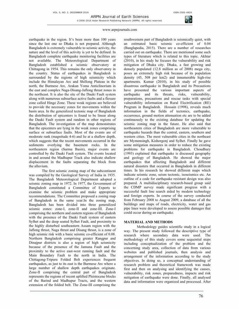
Earthquake: Earthquake is a sudden violent shaking of the ground, typically causing great destruction, as a result of movements within the earth’s crust or volcanic action. The causes of earthquake are movements within the Earth’s crust cause stress to build up at points of weakness, and rocks to deform. The stored energy is suddenly released as an earthquake.
Focus: The location where the earthquake begins. The ground ruptures at this spot, then seismic waves radiate outward in all directions.
Epicenter: Directly above the focus on the Earth's surface is the earthquake epicenter. Earthquake waves start at the focus and travels outward in all directions.
Fore shock: A fore shock is an earthquake that is smaller than a main shock, precedes it, and is causally related to it.
Aftershock: An earthquake of similar or lesser intensity that follows the main earthquake.
Figure-1. Theoretical terminologies of earthquake (Wordpress, 1999).
Seismic waves: Vibrations that travel outward from the earthquake fault at speeds of several miles per second. Although fault slippage directly under a structure can cause considerable damage, the vibrations of seismic waves cause most of the destruction during earthquakes.
Magnitude: The amount of energy released during an earthquake, which is computed from the amplitude of the seismic waves. A magnitude of 7.0 on the Richter scale indicates an extremely strong earthquake. Each whole number on the scale represents an increase of about 32 times more energy released than the previous whole number represents. Therefore, an earthquake measuring 6.0 is about 32 times more powerful than one measuring 5.0.
Intensity: Intensity is defined on the observations of damaged structures, presence of secondary effects and degree to which quake was felt by individuals. There are twelve level of intensity as per Modified Mercalli Intensity Scale.
Plate tectonics: Most Earthquakes are caused by Plate Tectonics. The earth's crust consists of a number of sections or plates that float on the molten rock of the mantle. These plates move on convection currents caused by heat rising from the center of the earth. The hot magma rises and spreads out on the surface, creating new crust. The crust spreads out forming a new plate until it meets another plate. One of the plates will be pushed down into the interior of the earth and reabsorbed into the mantle. Plates can also be compressed to push up mountains when they collide or move sideways along transform faults. The plates are the Earth's crust that floats on the molten rock in the center of the Earth.
Volcanic eruptions: Earthquakes are one of the indicators of increased volcanic activity leading up to an eruption. As magma forces its way up into a volcano, it pushes aside the rocks in its way, causing bulges in the ground and a flurry of earthquakes.
VOL. 5, NO. 2, DECEMBER 2016 ISSN 2305-493X
ARPN Journal of Earth Sciences ©2006-2016 Asian Research Publishing Network (ARPN). All rights reserved.
www.arpnjournals.com
78
RESULTS AND DISCUSSIONS Causes of earthquake
Earthquakes originate due to various reasons, which fall into two major categories via non-tectonic and tectonic. The origin of tectonic earthquakes is explained with the help of 'elastic rebound theory'. Earthquakes are distributed unevenly on the globe. However, it has been observed that most of the destructive earthquakes originate within two well-defined zones or belts namely, 'Circum-Pacific Belt' and 'Mediterranean-Himalayan Seismic Belt'. Earthquakes can happen along any type of plate boundary. They also occur along faults which are large cracks in the earth’s crust. Most faults are associated with large plate boundaries where violent earthquakes usually occur. Causes of earthquake are described below. An earthquake is caused by a sudden slip on a fault. The tectonic plates are always slowly moving, but they get stuck at their edges due to friction. When the stress on the edge overcomes the friction, there is an earthquake that releases energy in waves that travel through the earth’s crust and cause the shaking that we feel. Hot magma rises from the mantle at mid-ocean ridges pushing the plates apart. Earthquakes occur along the fractures that appear as the plates move apart.
Most earthquakes are minor tremors, while larger earthquakes usually begin with slight tremors, rapidly take the form of one or more violent shocks, and end in vibrations of gradually diminishing force called aftershocks. Earthquake is a form of energy of wave motion, which originates in a limited region and then spreads out in all directions from the source of disturbance. It usually lasts for a few seconds to a minute. The point within the earth where earthquake waves originate is called the focus, from where the vibrations spread in all directions. They reach the surface first at the point immediately above the focus and this point is called the epicenter. It is at the epicenter where the shock of the earthquake is first experienced. On the basis of the depth of focus, an earthquake may be termed as shallow focus (0-70 km), intermediate focus (70-300 km), and deep focus (> 300 km). The most common measure of earthquake size is the Richter's magnitude (M). The Richter scale uses the maximum surface wave amplitude in the seismogram and the difference in the arrival times of primary (P) and secondary (S) waves for determining magnitude (M). The magnitude is related to roughly logarithm of energy, E in ergs. Climate change and earthquake
It’s very tough to invoke climate change and earthquakes in the same sentence without strong evidence, a changing climate can affect the ground beneath our feet with derision. When the climate changed naturally in the past, and the planet emerged from an ice age, large ice sheets covering much of the planet retreated. They were so heavy that the resulting release of pressure on the earth’s crust caused it to `bounce back`, triggering earthquakes,
tremors, and even volcanic activity along pre-existing fault lines. Right now, the Earth is still responding to the end of the last ice age some 20,000 years ago when temperatures began to rise, causing large ice sheets to retreat, as shown here: McGuire suggests that if man-made climate change leads to more large ice sheets disappearing - like the one covering Greenland - this could lead to more shakes, rattles and rolls. Extreme weather is moving tectonic plates, scientists claim. People who are ridiculed for saying that earthquakes are a result of global warming could actually be right, scientists claim. Long-term climate change has the potential to spin Earth’s tectonic plates, according to a new study from the Australian National University. So in Bangladesh context high warming may cause the risk of earthquake there. But it is not scientifically proven that this is the only cause that next earthquake risk in Bangladesh. Earthquake recording system
Earthquakes are recorded by instruments called seismographs. The recording they make is called a seismogram. The seismograph has a base that sets firmly in the ground, and a heavy weight that hangs free. When an earthquake causes the ground to shake, the base of the seismograph shakes too, but the hanging weight does not. Instead the spring or string that it is hanging from absorbs all the movement. The difference in position between the shaking part of the seismograph and the motionless part is what is recorded. The strength of the shaking of the earthquake is measured by Richter scale. The magnitude is labeled as 3 or lower earthquake and crossing 7 high magnitudes that can causes serious damage population, life and buildings, establishments etc. Earthquake prediction
Scientists have tried many different ways of predicting earthquakes, but none have been successful. On any particular fault, scientists know there will be another earthquake sometime in the future, but they have no way of telling when it will happen. These are two questions that do not yet have definite answers. If weather does affect earthquake occurrence, or if some animals or people can tell when an earthquake is coming, we do not yet understand how it works. If we analyzed lots of research and article about the risk factor of earthquake in Bangladesh, most of them are prediction and own ideas. Some of them identified the present location and climate changes are the big factor for the possibility risk of earthquake in Bangladesh. But all these above argument have scientifically proved that climate change and weather do not effect or the main risk factor of the earthquake. We can say, if earthquakes took place in Bangladesh, it will be for the natural causes not directly induced by the climate change.
VOL. 5, NO. 2, DECEMBER 2016 ISSN 2305-493X
ARPN Journal of Earth Sciences ©2006-2016 Asian Research Publishing Network (ARPN). All rights reserved.
www.arpnjournals.com
79
Forces beneath Bangladesh Bangladesh is a small country in south Asia. Its
geography makes it unlike any other place on Earth. To the north of Bangladesh are the Hima layas, the world’s largest mountain range. Three great rivers- the Brahmaputra, Ganges and Meghna flows from the Himalayas and other nearby mountain ranges and merge in Bangladesh. These rivers deposit huge amounts of mud and sand. All this sediment forms the world’s largest delta. Bangladesh is also one of the rainiest places of the Earth. Bangladesh isn’t shaped by just rivers and flooding. It’s also shaped by what’s happening beneath the surface, where tectonic plates are shifting. Bangladesh is one of the most tectonically active regions in the world. It sits where three tectonic plates meet: the Indian Plate, the Eurasian Plate, and the Burmese Plate. The Indian Plate is moving northeast, slowly colliding with the Eurasian Plate. This collision formed the Himalayan Mountains and they are still rising. There are many active faults along this boundary, such as the enormous Dauki fault that borders northern Bangladesh. Movement along this fault formed the large Shillong Plateau. To the east, the Burmese Plate
pushes west against the Indian Plate. As the the India plate sub-ducts beneath the Burmese Plate, rocks fold and buckle to form the hills and valleys of the Burma Arc. Of course, active faults can also generate huge earthquakes and scientists think that a major earthquake is very closer to Bangladesh and only a matter of time. Earthquake Chronology in Bangladesh
Accurate historical information on earthquakes is very important in evaluating the seismic probability of Bangladesh in close coincidences with the tectonic elements. Information on earthquakes in and around Bangladesh is available for the last 250 years. The earthquake record suggests that since 1900 more than 100 moderate to large earthquakes occurred in Bangladesh, out of which more than 65 events occurred after 1960. This brings to light an increased frequency of earthquakes in the last 30 years. This increase in earthquake activity is an indication of fresh tectonic activity or propagation of fractures from the adjacent seismic zones.
Table-1. Chronology of important earthquakes placed in Bangladesh from 1548 to 2015.
1548 The first recorded earthquake in Sylhet and Chittagong were violently shaken, the earth opened in many places and threw up water and mud of a sulphurous smell.
1642 More severe damage occurred in Sylhet district. Buildings were cracked but there was no loss of life.
1663 Severe earthquake in Assam, which continued for half an hour and Sylhet district was not free from its shock.
1762
The great earthquake of April 2, which raised the coast of Foul island by 2.74m and the northwest coast of Chedua island by 6.71m above sea level and also caused a permanent submergence of 155.40 sq km near Chittagong. The earthquake proved very violent in Dhaka and along the eastern bank of the Meghna as far as Chittagong. In Dhaka 500 persons lost their lives, the rivers and jheels were agitated and rose high above their usual levels and when they receded their banks were strewn with dead fish. A large river dried up, a tract of land sank and 200 people with all their cattle were lost.
1775 Severe earthquake in Dhaka around April 10, but no loss of life.
1812 Severe earthquake in many places of Bangladesh around May 11. The earthquake proved violent in Sylhet
1865 Terrible shock was felt, although no serious damages occurred.
1869 Known as Catcher Earthquake. Severely felt in Sylhet but no loss of life. The steeple of the church was shattered, the walls of the courthouse and the circuit bungalow cracked and in the eastern part of the district the banks of many rivers caved in.
1885 Known as the Bengal Earthquake. Occurred on 14 July with 7.0 magnitude and the epicenter was at Manikganj. This event was generally associated with the deep-seated Jamuna Fault.
1889 Occurred on 10 January with 7.5 magnitudes and the epicenter at Jaintia Hills. It affected Sylhet town and surrounding areas.
1897
Known as the Great India Earthquake with a magnitude of 8.7 and epicenter at Shillong Plateau. The great earthquake occurred on 12 June at 5.15 pm, caused serious damage to masonry buildings in Sylhet town where the death toll rose to 545. This was due to the collapse of the masonry buildings. The tremor was felt throughout Bengal, from the south Lushai Hills on the east to Shahbad on the west. In Mymensingh. Heavy damage was done to the bridges on the Dhaka-Mymensingh railway and traffic was suspended for about a fortnight. Loss of life was not great, but loss of property was estimated at five million Rupees.
1918 Known as the Srimangal Earthquake. Occurred on 18 July with a magnitude of 7.6 and epicenter at Srimangal, Maulvi Bazar. Intense damage occurred in Srimangal, but in Dhaka only minor effects
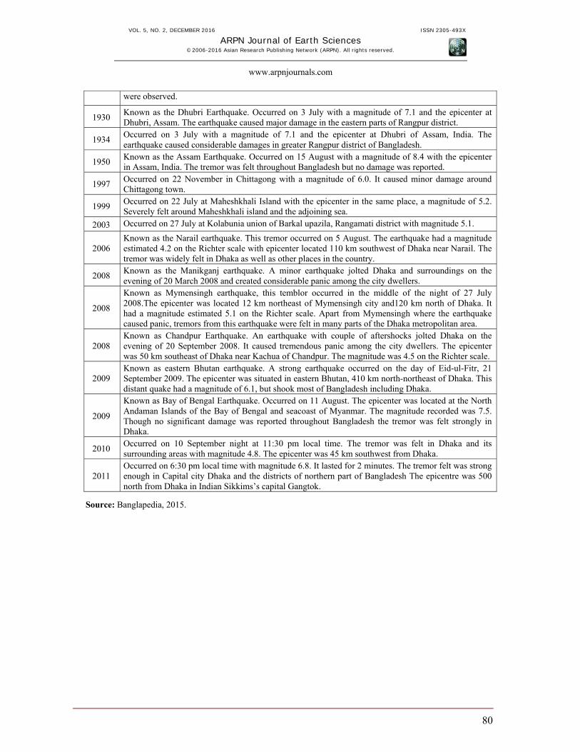
VOL. 5, NO. 2, DECEMBER 2016 ISSN 2305-493X
ARPN Journal of Earth Sciences ©2006-2016 Asian Research Publishing Network (ARPN). All rights reserved.
www.arpnjournals.com
80
were observed.
1930 Known as the Dhubri Earthquake. Occurred on 3 July with a magnitude of 7.1 and the epicenter at Dhubri, Assam. The earthquake caused major damage in the eastern parts of Rangpur district.
1934 Occurred on 3 July with a magnitude of 7.1 and the epicenter at Dhubri of Assam, India. The earthquake caused considerable damages in greater Rangpur district of Bangladesh.
1950 Known as the Assam Earthquake. Occurred on 15 August with a magnitude of 8.4 with the epicenter in Assam, India. The tremor was felt throughout Bangladesh but no damage was reported.
1997 Occurred on 22 November in Chittagong with a magnitude of 6.0. It caused minor damage around Chittagong town.
1999 Occurred on 22 July at Maheshkhali Island with the epicenter in the same place, a magnitude of 5.2. Severely felt around Maheshkhali island and the adjoining sea.
2003 Occurred on 27 July at Kolabunia union of Barkal upazila, Rangamati district with magnitude 5.1.
2006 Known as the Narail earthquake. This tremor occurred on 5 August. The earthquake had a magnitude estimated 4.2 on the Richter scale with epicenter located 110 km southwest of Dhaka near Narail. The tremor was widely felt in Dhaka as well as other places in the country.
2008 Known as the Manikganj earthquake. A minor earthquake jolted Dhaka and surroundings on the evening of 20 March 2008 and created considerable panic among the city dwellers.
2008
Known as Mymensingh earthquake, this temblor occurred in the middle of the night of 27 July 2008.The epicenter was located 12 km northeast of Mymensingh city and120 km north of Dhaka. It had a magnitude estimated 5.1 on the Richter scale. Apart from Mymensingh where the earthquake caused panic, tremors from this earthquake were felt in many parts of the Dhaka metropolitan area.
2008 Known as Chandpur Earthquake. An earthquake with couple of aftershocks jolted Dhaka on the evening of 20 September 2008. It caused tremendous panic among the city dwellers. The epicenter was 50 km southeast of Dhaka near Kachua of Chandpur. The magnitude was 4.5 on the Richter scale.
2009 Known as eastern Bhutan earthquake. A strong earthquake occurred on the day of Eid-ul-Fitr, 21 September 2009. The epicenter was situated in eastern Bhutan, 410 km north-northeast of Dhaka. This distant quake had a magnitude of 6.1, but shook most of Bangladesh including Dhaka.
2009
Known as Bay of Bengal Earthquake. Occurred on 11 August. The epicenter was located at the North Andaman Islands of the Bay of Bengal and seacoast of Myanmar. The magnitude recorded was 7.5. Though no significant damage was reported throughout Bangladesh the tremor was felt strongly in Dhaka.
2010 Occurred on 10 September night at 11:30 pm local time. The tremor was felt in Dhaka and its surrounding areas with magnitude 4.8. The epicenter was 45 km southwest from Dhaka.
2011 Occurred on 6:30 pm local time with magnitude 6.8. It lasted for 2 minutes. The tremor felt was strong enough in Capital city Dhaka and the districts of northern part of Bangladesh The epicentre was 500 north from Dhaka in Indian Sikkims’s capital Gangtok.
Source: Banglapedia, 2015.

VOL. 5, NO. 2, DECEMBER 2016 ISSN 2305-493X
ARPN Journal of Earth Sciences ©2006-2016 Asian Research Publishing Network (ARPN). All rights reserved.
www.arpnjournals.com
81
Figure-2. Major faults existing in Bangladesh (Wordpress, 2014). Earthquake vulnerability of Bangladesh
In the immediate outside of the eastern frontier of Bangladesh, Eurasian and Indian Plate boundary exist while within the country; three major fault lines- Madhupur fault, Dauki fault and Eastern Plate boundary fault are located. In the last two hundred and fifty years, Bangladesh has experienced eight major strong ground motion (magnitude over 7.0), of which, epicenter of two earthquakes (Srimongal Earthquake of 1918, and Bengal Earthquake of 1885) were located within the country. Due to the existences of geological plate boundary and fault
lines, occurrences of historical damaging earthquakes in and around the country and long-term silences of happening potential earthquake (seismic-gap) across the region, possibility of occurring strong earthquake is increasing over the time period. Since it is not possible to predict earthquake, awareness (what to do) with regard to this devastating phenomena can save the live and livelihood to a great extend of the dwellers living at risk. Taking care of the structural and non-structural elements, earthquake vulnerability can be reduced a lot.
VOL. 5, NO. 2, DECEMBER 2016 ISSN 2305-493X
ARPN Journal of Earth Sciences ©2006-2016 Asian Research Publishing Network (ARPN). All rights reserved.
www.arpnjournals.com
82
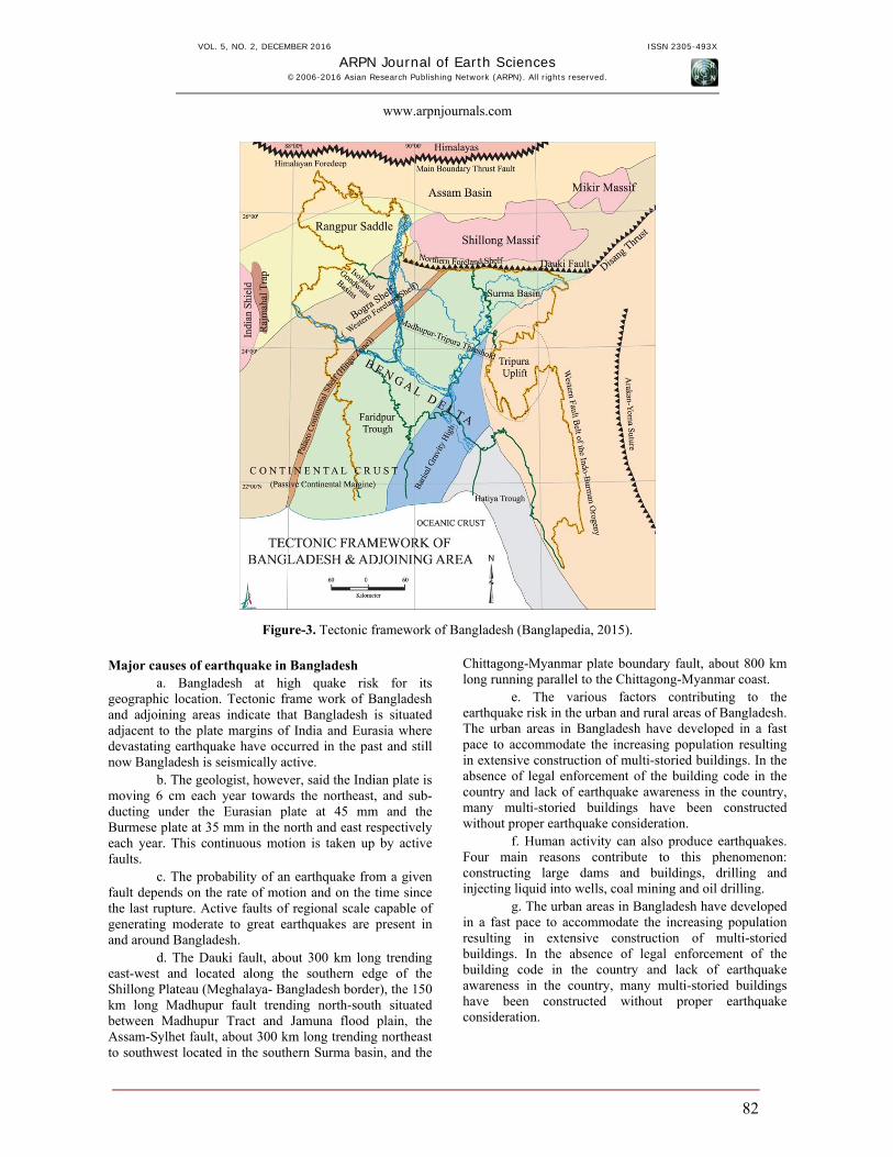
Figure-3. Tectonic framework of Bangladesh (Banglapedia, 2015). Major causes of earthquake in Bangladesh
a. Bangladesh at high quake risk for its geographic location. Tectonic frame work of Bangladesh and adjoining areas indicate that Bangladesh is situated adjacent to the plate margins of India and Eurasia where devastating earthquake have occurred in the past and still now Bangladesh is seismically active.
b. The geologist, however, said the Indian plate is moving 6 cm each year towards the northeast, and sub-ducting under the Eurasian plate at 45 mm and the Burmese plate at 35 mm in the north and east respectively each year. This continuous motion is taken up by active faults.
c. The probability of an earthquake from a given fault depends on the rate of motion and on the time since the last rupture. Active faults of regional scale capable of generating moderate to great earthquakes are present in and around Bangladesh.
d. The Dauki fault, about 300 km long trending east-west and located along the southern edge of the Shillong Plateau (Meghalaya- Bangladesh border), the 150 km long Madhupur fault trending north-south situated between Madhupur Tract and Jamuna flood plain, the Assam-Sylhet fault, about 300 km long trending northeast to southwest located in the southern Surma basin, and the
Chittagong-Myanmar plate boundary fault, about 800 km long running parallel to the Chittagong-Myanmar coast.
e. The various factors contributing to the earthquake risk in the urban and rural areas of Bangladesh. The urban areas in Bangladesh have developed in a fast pace to accommodate the increasing population resulting in extensive construction of multi-storied buildings. In the absence of legal enforcement of the building code in the country and lack of earthquake awareness in the country, many multi-storied buildings have been constructed without proper earthquake consideration.
f. Human activity can also produce earthquakes. Four main reasons contribute to this phenomenon: constructing large dams and buildings, drilling and injecting liquid into wells, coal mining and oil drilling.
g. The urban areas in Bangladesh have developed in a fast pace to accommodate the increasing population resulting in extensive construction of multi-storied buildings. In the absence of legal enforcement of the building code in the country and lack of earthquake awareness in the country, many multi-storied buildings have been constructed without proper earthquake consideration.
VOL. 5, NO. 2, DECEMBER 2016 ISSN 2305-493X
ARPN Journal of Earth Sciences ©2006-2016 Asian Research Publishing Network (ARPN). All rights reserved.
www.arpnjournals.com
83
Factors contributing to earthquake risks in Bangladesh
The various factors contributing to the earthquake risk in the urban and rural areas of Bangladesh may be summarized below: a) Absence of earthquake awareness b) High population density and construction lacking
of legal enforcement of building code and its seismic design provisions.
c) Poor quality of construction materials and improper construction method.
d) Economic limitation. e) Possibility of fire outbreaks due to rupture of gas
pipelines or electric short-circuit during an earthquake and inadequate fire fighting facilities.
f) Inadequate road width and space between buildings preventing rescue operations and fire-fighting vehicles to reach certain areas.
g) Inadequate exit (at the same time) for the occupants of a building during an emergency.
H) Lack of facilities (rescue equipment, trained staff, medical personnel, and medical facilities) and preparedness for emergency response and recovery operations following an earthquake.
i) Lack of earthquake resistant design of life line facilities which include power plants, power stations, bridges, communication control stations, gas and water supply stations earthquake resistant design. Etc.
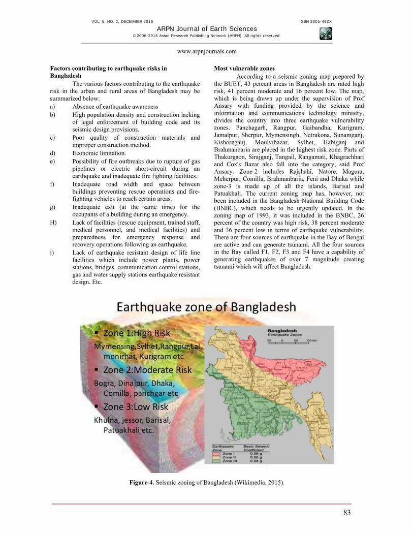
Most vulnerable zones According to a seismic zoning map prepared by
the BUET, 43 percent areas in Bangladesh are rated high risk, 41 percent moderate and 16 percent low. The map, which is being drawn up under the supervision of Prof Ansary with funding provided by the science and information and communications technology ministry, divides the country into three earthquake vulnerability zones. Panchagarh, Rangpur, Gaibandha, Kurigram, Jamalpur, Sherpur, Mymensingh, Netrakona, Sunamganj, Kishoreganj, Moulvibazar, Sylhet, Habiganj and Brahmanbaria are placed in the highest risk zone. Parts of Thakurgaon, Sirajganj, Tangail, Rangamati, Khagrachhari and Cox's Bazar also fall into the category, said Prof Ansary. Zone-2 includes Rajshahi, Natore, Magura, Meherpur, Comilla, Brahmanbaria, Feni and Dhaka while zone-3 is made up of all the islands, Barisal and Patuakhali. The current zoning map has, however, not been included in the Bangladesh National Building Code (BNBC), which needs to be urgently updated. In the zoning map of 1993, it was included in the BNBC, 26 percent of the country was high risk, 38 percent moderate and 36 percent low in terms of earthquake vulnerability. There are four sources of earthquake in the Bay of Bengal are active and can generate tsunami. All the four sources in the Bay called F1, F2, F3 and F4 have a capability of generating earthquakes of over 7 magnitude creating tsunami which will affect Bangladesh.
Figure-4. Seismic zoning of Bangladesh (Wikimedia, 2015).
VOL. 5, NO. 2, DECEMBER 2016 ISSN 2305-493X
ARPN Journal of Earth Sciences ©2006-2016 Asian Research Publishing Network (ARPN). All rights reserved.
www.arpnjournals.com
84
Almost seven major earthquakes strucked Bangladesh during the last 150 years and only two had the epicenter within the country. Based on the epicenters of earlier earthquakes, Dhaka has crossed 130 years; Chittagong has crossed 250 years and Sylhet about 100 years, which now raises the prospect of a major earthquake striking Bangladesh.
Fault zones like Dauki fault zone, Shahjibazar fault zone and Tripura to Assam fault zone are very active and have been generating energy for quite a long time but as no earthquake occurred in those areas, it is a matter of time before the big one strikes. Major eight fault zones are active in Bangladesh. They are Bogra fault zone, Tanore fault zone in Rajshahi, Tripura fault zone, Sitakunda-Teknaf fault zone, Dauki fault zone (Haluaghat Fault), Dhubri fault zone, Chittagong fault zone, Shahjibazar fault zone (sub-Dauki fault) and Rangamati fault zone (Borcal). Any minor earthquake might took place due to the activity in the local small fault zones, thus increasing the chances of a major jolt happening. Besides, a strong earthquake could occur in the plate boundaries as the 100-year alarm bells have passed. Bangladesh is close to the meeting point of the Indian, Eurasian and Burma (Myanmar) plates. The movement of Indian and Eurasian plates has been locked at the foot of the Himalayas for many years, storing strain energy. When the lock is released it will let out the strain energy causing major earthquakes that will affect Bangladesh, northeast part of India and Myanmar, Ansary explained. As Bangladesh is located in a tectonically active much of the country including Chittagong, Sylhet, Dhaka, Rangpur, Bogra, Mymenshing, Comilla, Rajshahi are very much vulnerable to major earthquake disaster. Considering geology and tectonics of Bangladesh and neighborhood five tectonic blocks can be identified which have been active in producing damaging earthquakes. These are: a. Bogra fault zone
b. Tripura fault zone
c. Sub Dauki fault zone
d. Shillong fault zone
e. Assam fault zone
Considering fault length, fault characteristics, earthquake records etc the maximum magnitude of earthquakes that can be produced in different tectonic blocks were predicted in below: Tectonic block and maximum predicted magnitude of earthquake a. Bogra fault zone 7.0
b. Tripura fault zone 7.0
c. Sub Dauki fault zone 7.3
d. Shillong fault zone 7.0
e. Assam fault zone 8.5
As Bangladesh is located close to the boundary of two active plates (Indian plate in the west and Eurasian plate in the east and north) the country has always been under threat of an earthquake that might be so catastrophic it will kill people in less than a minute. With the frequency of earthquakes on the increase, it is natural for people to be scared as experts consider them to be advance warning of what lies ahead. And with tremors in the Chittagong region increasing in frequency, experts believe we can expect a major one any day. Thus, Bangladesh can be divided into three main earthquake zones: Zone-1: Sylhet-Mymensingh is with the possible
magnitude of 7 on Richter scale. Zone-2: Chittagong-Comilla-Dhaka and Tangail are with
the possible magnitude of 6 on Richter scale. Zone-3: Rest of the country is with possible magnitude of
6 on Richter scale.
The entire northern region from Lalmonirhat to Bogora and greater Mymensingh and Syleht are prone to powerful earthquake. The recent rise and mushroom growth of high-rise buildings in and around Dhaka and other main cities could be great disaster, if a major tremor of the magnitude is over 7 on Richter scale. There has been no effective post-quake disaster management program that could tackle emergence. For determining zone coefficients, comparisons of acceleration contour maps with earthquake risk map of the USA indicate that Bangladesh is comparatively less seismic than California. This indicates that lower values of zone coefficients are appropriate in Bangladesh. But unplanned urbanization and rapid growth of population make this zone more vulnerable than that of USA. Emerging risks in Dhaka city
Dhaka city, the soul of Bangladesh is highly vulnerable to the earthquake disaster due to high density of population, unplanned infrastructure and close proximity with India and Myanmar’s active seismic area, poor economic condition, poor emergency preparation and recovery capability. With more than 13 million people, and an average of 45,000 people per square kilometer, Dhaka is one of the world’s most crowded cities. And it’s expanding quickly. Many of these new buildings, bridges, and roads are not built to hold up in earthquakes. The soft, wet delta soil makes them even more vulnerable. An earthquake could also spark a tsunami or cause rivers to overflow, which could flood the city. Scientists and officials in Bangladesh hope to update and enforce building codes, educate people about how to prepare for earthquakes, and train rescue workers. They also want to
VOL. 5, NO. 2, DECEMBER 2016 ISSN 2305-493X
ARPN Journal of Earth Sciences ©2006-2016 Asian Research Publishing Network (ARPN). All rights reserved.
www.arpnjournals.com
85
prepare surrounding areas, especially near rivers. A major earthquake could shift a river’s course and lead to widespread flooding. Among the cities in Bangladesh, Dhaka is most vulnerable for earthquake. Located on two fault-lines, Dhaka also ranks among the 20 cities most vulnerable to earthquake in the world. Bangladesh is sitting at a high risk earthquake zone and an unprecedented human disaster may occur anytime for even a moderate to heavy tremor. A powerful earthquake needs at least 100-150 years to be originated for a particular region and in that sense it is overdue for Bangladesh. As 112 years have already been elapsed since a heavy tremor from Dawki Fault hit the region, exposing Bangladesh to highly vulnerable of a powerful earthquake. He further said that numbers of moderate to heavy earthquakes are overdue for some parts of the country, including the capital. So, time has come to get ready for the possible disasters by raising awareness. Dhaka is one of the earthquake vulnerable city among other major cities due to its unplanned urbanization. The government to demolish Dhaka's old and risky buildings to minimize casualties in such disasters. Besides, causalities and damages could also be minimized though strict enforcement of the Bangladesh National Building Code (BNBC). A mass awareness should be created as part of earthquake preparedness. And the government should procure necessary equipment for carrying out rescue operation after any earthquake event. The government has already procured some equipment to conduct search and rescue operation after disasters, which is inadequate to address any earthquake aftermath. Dhaka is too much vulnerable of earthquake disaster due to some reasons. First of all the population density is very high in Dhaka city. Secondly, it is predicted that the secondary hazard like fire break out from gas and electricity line will have more disastrous impact after earthquake. Thirdly, not only building codes are not maintain during construction time of most of the high rise apartment buildings and most garment factory buildings but also they have been constructed without open spaces and most have encroached upon the streets and roadways. As a result, the collapse of these structures will block streets, further hindering rescue operations. Earthquake preparedness
Earthquake cannot be prevented. But certainly it is high time to be much more concerned about the probable impending earthquake in order to minimize the loss of lives and property in national interest. For better understanding of all the possibilities of earthquake risk reduction, it is important to classify them in terms of the role that each one of them could play. Therefore, in the pre-earthquake phase, preparedness, mitigation and prevention are concepts to work on. Post-disaster, immediate rescue and relief measures including temporary sheltering soon after an earthquake until about 3 months later and re-construction and re-rehabilitation measures for a period of about six months to three years need to follow. To encapsulate, the most effective measures of earthquake
risk reduction are pre-disaster mitigation, preparedness and preventive measures to reduce vulnerability and expeditious, effective rescue and relief actions immediately after the occurrence of the earthquake. Depending upon the calamity and its consequences, strategies can also be divided into long term (five to fifteen years), medium term (one to five years) and short term (to be taken up immediately in high risk areas). Since it has been realized that earthquakes don't kill people but faulty constructed buildings do, the task of reducing vulnerability of structures and buildings will be the key to earthquake risk reduction. Also, pre-disaster preparedness through a post-earthquake response plan, including training of the concerned personnel in various roles, is considered essential for immediate and effective response after an earthquake occurrence. The major action points are highlighted in the following paragraphs. Pre-disaster preparedness Long-term measures i. Bangladesh should prepare a proper seismic risk map
with zoning and micro-zoning depending on the intensity and frequency of seismic activities. There should be detailed seismic risk map especially for Dhaka city considering its poor physical structure and high population density.
ii. There should be appropriate standard building codes and specifications in construction practice to safeguard against seismic forces. More importantly, seismic codes and specification should be followed in all public and private construction and law enforcement authorities to take action against the violators of building codes.
iii. Incorporating earthquake resistant features in all buildings at high-risk areas.
iv. Making all public utilities like water supply systems, communication networks, electricity lines etc. earthquake-proof. Creating alternative arrangements to reduce damages to infrastructure facilities.
v. Constructing earthquake-resistant community buildings and buildings (used to gather large groups during or after an earthquake) like schools, madrasas, hospitals, prayer halls, etc. especially in seismic zones of moderate to higher intensities.
vi. Supporting non governmental organization in various aspects of disaster mitigation, preparedness and prevention and post-disaster management.
vii. Evolving educational curricula in architecture and engineering institutions and technical training in polytechnics and schools to include disaster related topics.
VOL. 5, NO. 2, DECEMBER 2016 ISSN 2305-493X
ARPN Journal of Earth Sciences ©2006-2016 Asian Research Publishing Network (ARPN). All rights reserved.
www.arpnjournals.com
86
Medium term measures i. Retrofitting of weak structures in highly seismic
zones. It is very important for Dhaka city as 60% building of this city are not able to survive against ground shaking.
ii. As community peoples are the ultimate victim of any disaster, the communities involved in the process of disaster mitigation through education and awareness. In this case Community-based Earthquake Risk Management process should be initiated by promoting awareness among community people what should be the response in times of earthquake.
iii. Networking of local NGOs working in the area of disaster management. They should be trained up to strengthen their capacity and capabilities.
Short term measures
As earthquake has no warning system there should be some short term measure which will considerably reduce the vulnerability in individual level such as, i. Place large and heavy objects at the ground level or in
the lower shelves of storage shelves. ii. Keep china-ware, glass ware and other breakable
objects in such a way that these do not fall off the shelves with upturned lips will help holding such materials.
iii. Appliances that can be moved can break electrical or gas lines and must be anchored to a stable location with flexible connections.
iv. Flammable liquids must be stored securely away from flame.
v. Beds should not be placed near windows. vi. Every member of the family should know how to
switch off electricity and gas mains at the time of emergency
vii. Every family should keep a first aid box always ready and every family member should know how to use it because outside help may be delayed.
Organizations and strategy for earthquake disaster mitigation and rescue a) Community awareness buildup and training
The government of Bangladesh should set up a special body comprising of representative from the ministry of health, finance, food and disaster management, housing, Fire brigade and to take lead and coordination role. They will prepare and disseminate special guidelines and launch extensive mass awareness programs for earthquake; the awareness must include city dwellers, government officials, municipality officials, politicians, engineers, architects, designers, builders, medical people,
etc. They will develop appropriate training materials for different groups, such as planners, engineers, contractors, masons, bar binders, volunteers, fire fighters, doctors, nurses; first aid providers, etc. take training programs at the appropriate levels to impart these trainings. b) Local voluntary disaster management organizations and volunteer activities
The local community should recognize the need for getting organized and capacitated. It is necessary to reform the Ward Disaster Preparedness Committee (WDPC). The WDPC was consisted of 11 members and 12-15 volunteers. The WDPC members were respected people of the community such as teachers, Imams, social workers, local elite and businessmen, while the volunteers groups were from the younger generation including scouts and guides. Training is necessary for proper volunteer activities focusing on: a) improving their knowledge on earthquake disaster b) motivating them for preparedness to cope with
earthquake c) Producing a work-plan for WDPC.
c) Preparation of data base and seismic hazard maps
Develop a comprehensive regional catalog of all recorded historical earthquake in Bangladesh and adjacent regions that influence the country’s seismic hazards. Prepare a comprehensive regional seismic hazard map of Bangladesh using the existing information and incorporate appropriate building code. Develop Bangladeshi scientists including seismologists, engineers, architects, geologists, GIS and remote sensing experts and other technicians through training and higher education programs to assume leadership in all aspects of earthquake hazards assessment studies in Bangladesh. d) Building code and vulnerability zoning
It is necessary to update the Bangladesh National Building Code (BNBC) and make the document legal, make it binding for all construction activities. Demonstrate retrofitting and introduce motivation program of retrofitting through municipality leadership (for Dhaka city may be RAJUK). Install and operate seismic instrument at suitable locations in the country. The government should strictly implement building codes as well as identify and retrofit the vulnerable buildings. e) Emergency preparedness master plan:
It is necessary to formulate a comprehensive disaster management master plan by considering the devastating seismic hazards for cities and towns of Dhaka. The master plan should emphasize the followings; community awareness buildup, vulnerability zoning, necessary rescue and recovery equipments and man power, fire extinguishing equipments, well coordination among information communication and critical services,
VOL. 5, NO. 2, DECEMBER 2016 ISSN 2305-493X
ARPN Journal of Earth Sciences ©2006-2016 Asian Research Publishing Network (ARPN). All rights reserved.
www.arpnjournals.com
87
standing order on disaster (SOD), coordination between local and central government activities. f) Risk transfer and predetermined place to provide emergency services
Earthquake never be resisted but we can transfer risk in monetary unit by creating insurance policy and government should take initiatives for that. After earthquake the emergency services should the operated from preselected area of a specific zone. Community must be informed about the service point before earthquake. g) Civil-military cooperation
Civil- military collaboration is an important consideration in the field of emergency response. Community volunteers, Bangladesh armed forces and civil defense perform jointly in rescue and recovery operations and also responsible to provide emergency services. h) Equipment for rescue and recovery
Equipments are necessary to meet the needs of emergency response. Without the collection of proper equipments rescue and recovery is unimaginable. So Bangladesh government should take necessary steps to collect the modern equipment for proper management of earthquake impact. It is important to assess the rescue equipment stock and their usability at the time of response. i) Partial decentralization
Whole economic, political and cultural activities are centered in Dhaka. In the context of earthquake the economy, politics and culture of Bangladesh are very much vulnerable. So it requires partial decentralization for smooth motion of economic, organizational and political activities if Dhaka faces any disaster. j) Planning for water and air ways
The existing road communication system in and around Dhaka will be affected by earthquake but the effect will be less in water ways. So there should be plan to restore the existing water ways (canals, rivers in and around Dhaka) for the use during earthquake emergency period. Dhaka city has three rivers around it -- Buriganga, Sitalakhya and Turag. These rivers can be again turned into life blood for the city. These rivers need extensive dredging to ensure navigability round the year. The city circular river way can be a very useful communication route. Air craft will also performed during emergency response. This will be an effective way in the field of rescue and emergency services distribution. Special care should be taken for international airport in Dhaka. l) Assessment of government facilities
It is necessary to assess the fire fighting strengths and take appropriate training, provisioning of appropriate
fire fighting equipment, and personnel for individual cities. Assessment should be done to determine the capacity of hospitals and others medical centers, doctors, nurses, other technical personnel, medicine and equipment stock to deal with large casualties. It is important to assess the capacity of the existing blood banks and development of a large blood donors list including database of their contact address and blood groups. m) Information, communication and critical services
Government authority is responsible for the transmission of information to the local community about disaster. Wireless communication system may play significant role. Mass awareness among the general people regarding earthquake, not to get panic, what to do if an earthquake hits, where to get shelter, where to phone for help etc should be undertaken daily in different television, radio, newspaper, talk show. There should be well communication system among government and community level organization. The availability of critical services should be ensured by the government to manage the impact of earthquake. n) Relationship with foreign government and organizations
The government of Bangladesh should maintain friendly relation with government of developed and developing countries and donor organizations. That will be helpful in the field of disaster management. Government can able to recover the impact within short period if there is any agreement for disaster management assistance among techno trade countries like India, China, Japan and USA. FINDINGS AND RECOMMENDATION
Mass awareness should be created among the city dwellers about earthquake. The government can make people aware about earthquake through television programs. It should also arrange earthquake demonstration so that people can learn how to escape from a devastating earthquake. Apart from this, a proper gas leakage management, power supply control, fire fighting, alternative power generation, wireless communication system, heavy equipment for removing debris and emergency clinical facilities are necessary to address earthquake aftermath. The government organizations and strategies and community based organizations is important for the management of devastating impact of earthquake in Dhaka city. By introducing proper policy and planning for disaster management, community awareness build up and training, proper implementation of national building code, well coordination among government organizations and infrastructures and non-government organizations, enrichment of well equipped rescue team can limit the impact in a manageable boundary. The policy issues regarding disaster like earthquake could be handled mostly at the national level but planning and implementation
VOL. 5, NO. 2, DECEMBER 2016 ISSN 2305-493X
ARPN Journal of Earth Sciences ©2006-2016 Asian Research Publishing Network (ARPN). All rights reserved.
www.arpnjournals.com
88
issues are to be handled at the local community level. The earthquake hazards can never be resisted but the severe damages of earthquake disaster in Dhaka city can be reduced by increasing capacity as it reduces the risk and vulnerability. Guidelines to reduce earthquake damage for individuals Before the earthquake At home a) Reinforcing shelving, fixing tall furniture to the wall
and keeping items low and safe b) Recognizing the shelters and their routes both at home
and nearby. c) Recognizing the place of switch for gas and electricity
and how to turn off. d) Preparing an emergency box (First aid) and fire
extinguishers. e) In case of any problem in the building, ask licensed
engineers or agencies to check and retrofit it. f) Check the equipments for fire fighting and exercise
the plan for disaster prevention and rescue regularly
In the public place a) Propose an emergency plan and assign the staffs or
servers to take in charge of the disaster prevention and emergency response.
b) Check the equipments for fire fighting regularly. c) Exercise the disaster prevention regularly. d) Check the billboard and the shelter from the sun or
any other potentially dislodged item constantly.
During the earthquake
Stay as safe as possible during an earthquake. Be aware that some earthquakes are actually fore shocks and a larger earthquake might occur. Minimize your movements to a few steps to a nearby safe place and stay indoors until the shaking has stopped and you are sure exiting is safe. If indoors a) DROP to the ground; take COVER by getting under a
sturdy table or other piece of furniture; and HOLD ON on until the shaking stops. If there isn’t a table or desk near you, cover your face and head with your arms and crouch in an inside corner of the building.
b) Stay away from glass, windows, outside doors and walls, and anything that could fall, such as lighting fixtures or furniture.
c) Stay in bed if you are there when the earthquake strikes. Hold on and protect your head with a pillow,
unless you are under a heavy light fixture that could fall. In that case, move to the nearest safe place.
d) Use a doorway for shelter only if it is in close proximity to you and if you know it is a strongly supported, load-bearing doorway.
e) Stay inside until shaking stops and it is safe to go outside. Research has shown that most injuries occur when people inside buildings attempt to move to a different location inside the building or try to leave.
f) Be aware that the electricity may go out or the sprinkler systems or fire alarms may turn on.
g) DO NOT use the elevators.
If outdoors a) Stay there. b) Move away from buildings, streetlights, and utility
wires. c) Once in the open, stay there until the shaking stops.
The greatest danger exists directly outside buildings, at exits, and alongside exterior walls. Many of the 120 fatalities from the 1933 Long Beach earthquake occurred when people ran outside of buildings only to be killed by falling debris from collapsing walls. Ground movement during an earthquake is seldom the direct cause of death or injury. Most earthquake-related casualties result from collapsing walls, flying glass, and falling objects.
If in a moving vehicle a) Stop as quickly as safety permits and stay in the
vehicle. Avoid stopping near or under buildings, trees, overpasses, and utility wires.
b) Proceed cautiously once the earthquake has stopped. Avoid roads, bridges, or ramps that might have been damaged by the earthquake.
If trapped under debris a) Do not light a match. b) Do not move about or kick up dust. c) Cover your mouth with a handkerchief or clothing. d) Tap on a pipe or wall so rescuers can locate you. Use
a whistle if one is available. Shout only as a last resort. Shouting can cause you to inhale dangerous amounts of dust.
What to do after an earthquake a) Check yourself for injuries. Often people tend to
others without checking their own injuries. You will be better able to care for others if you are not injured or if you have received first aid for your injuries.
VOL. 5, NO. 2, DECEMBER 2016 ISSN 2305-493X
ARPN Journal of Earth Sciences ©2006-2016 Asian Research Publishing Network (ARPN). All rights reserved.
www.arpnjournals.com
89
b) Protect yourself from further danger by putting on long pants, a long-sleeved shirt, sturdy shoes, and work gloves. This will protect your from further injury by broken objects.
c) After you have taken care of yourself, help injured or trapped persons. Don't try to move seriously injured people unless they are in immediate danger of further injury.
d) Look for and extinguish small fires. Eliminate fire hazards. Putting out small fires quickly, using available resources, will prevent them from spreading. Fire is the most common hazard following earthquakes. Fires followed the San Francisco earthquake of 1906 for three days, creating more damage than the earthquake.
e) Leave the gas on at the main valve, unless you smell gas or think its leaking. It may be weeks or months before professionals can turn gas back on using the correct procedures. Explosions have caused injury and death when homeowners have improperly turned their gas back on by themselves.
f) Clean up spilled medicines, bleaches, gasoline, or other flammable liquids immediately. Avoid the hazard of a chemical emergency.
g) Open closet and cabinet doors cautiously. Contents may have shifted during the shaking of an earthquake and could fall, creating further damage or injury.
h) Inspect your home for damage. Get everyone out if your home is unsafe. Aftershocks following earthquakes can cause further damage to unstable buildings. If your home has
i) Experienced damage, get out before aftershocks happen.
j) Help neighbours who may require special assistance. Elderly people and people with disabilities may require additional assistance. People who care for them or who have large families may need additional assistance in emergency situations.
k) Listen to a portable, battery-operated radio (or television) for updated emergency information and instructions. If the electricity is out, this may be your main source of information. Local radio and local officials provide the most appropriate advice for your particular situation.
l) Expect aftershocks. Each time you feel one, drop, cover, and hold on! Aftershocks frequently occur minutes, days, weeks, and even months following an earthquake. Watch out for fallen power lines or broken gas lines, and stay out of damaged areas. Stay out of damaged buildings. If you are away from home, return only when authorities say it is safe.
Damaged buildings may be destroyed by aftershocks following the main quake.
m) Use battery-powered lanterns or flashlights to inspect your home. Kerosene lanterns, torches, candles, and matches may tip over or ignite flammables inside.
n) Avoid smoking inside buildings. Smoking in confined areas can cause fires.
o) When entering buildings, use extreme caution. Building damage may have occurred where you least expect it. Carefully watch every step you take.
p) Watch animals closely. Leash dogs and place them in a fenced yard. The behaviour of pets may change dramatically after an earthquake. Normally quiet and friendly cats and dogs may become aggressive or defensive.
q) Take pictures of the damage, both to the house and its contents, for insurance claims.
CONCLUSIONS
Bangladesh is situated at high risk zone for earthquake and an unprecedented human disaster may occur in the country anytime for even a moderate to heavy tremor. It is apparent that the preparedness to face a major earth quake in Bangladesh is very poor. This is because of lack of coordination among various agencies like ministry of finance, health, food and disaster management, housing and NGO’s. More over there is little awareness among the people on how to face such calamities. Lack of support facilities like improved fire brigade and civil defence activities, establishment of multidisciplinary hospital to accommodate large number of earthquake victims, physical and mental support, communication by ambulances, transport vehicles, adequate number of drilling equipment, bulldozers etc. So it is obvious that if a major earthquake hits Bangladesh it will create havoc and damage in terms of life, properties that is unimaginable. It is evident from the above that we are facing a great challenge to adequately manage a major earthquake which may happen anytime in Bangladesh. To minimize suffering of the people, loss of properties and major casualties the government media, doctors, engineers, lawyer’s people’s representatives and mass media and all level of people should come forward with strong voice to formulate a central body to monitor this disaster, buy necessary equipments to cope, arrange establishment of multidisciplinary hospitals in the outside of danger zone immediately. Also mass awareness among the general people regarding earthquake, what to do if an earthquake hits, where to get shelter, where to phone for help etc should be undertaken daily in different television, radio, newspaper, talk show. The policy issues regarding disaster like earthquake could be handled mostly at the national level but planning and implementation issues are to be handled at the local level. Finally proper implementation of national building code and capacity building can reduce
VOL. 5, NO. 2, DECEMBER 2016 ISSN 2305-493X
ARPN Journal of Earth Sciences ©2006-2016 Asian Research Publishing Network (ARPN). All rights reserved.
www.arpnjournals.com
90
the vulnerability and risk of earthquake hazard in Bangladesh. REFERENCES Akhter S.H. 2010. Earthquakes of Dhaka. In: Environment of Capital Dhaka - Plants Wildlife Gardens Parks Air, Water and Earthquake. M.A. Islam (Ed.). Asiatic Society of Bangladesh. pp. 401-426. Ali M.H. 1998. Earthquake Database and Seismic Zoning of Bangladesh. Department of Civil Engineering, BUET, Dhaka, Bangladesh. Ali M.H. and Choudhury J.R. 2001, Assessment of seismic hazard in Bangladesh. Ameen S. 2003. The Earthquake Scenario in Bangladesh. Senior Programme Manager, USAID. 2013. American museum of natural history, Earthquake risks in Bangladesh. pp. 2-5. Banglapedia, Earthquake. 2015. Natural Science. Bolt B.A. 2005. Earthquakes, W.H. Freeman and Company, New York, NY. Choudhury J.R. 1993. Seismicity in Bangladesh, Bangladesh University of Engineering and Technology (BUET) Dhaka, Bangladesh. Choudhury J.R. and Ali M.H. 1994. Seismic Zoning of Bangladesh, paper presented in the Seminar on Recent Development Earthquake Disaster Mitigation, Organized by IEB and TAEE, Dhaka, Bangladesh. DPF (Disaster Preparedness Forum), 2003, Bangladesh Disaster Report 2002. Disaster Preparedness Forum, Dhaka. GSB. 1979. Seismic zoning map of Bangladesh and outline of code for earthquake resistant design of structures, Geological Survey of Bangladesh. pp. 1-42. Hossain, K.M. 1988. Tectonic significance and earthquake occurs in Bangladesh. J. Geol. Soc. 7: 1-11. Islam, N. 2005, Dhaka Now: Contemporary Urban Development. Bangladesh Geographical Society, Dhaka, Bangladesh. Karim and Rahman. 2002. Possible effect of a moderate earthquake on existing infrastructures of Dhaka City: A
Geological-geotechnical overview. Bangladesh Journal of Science and Technology. 4(2):193-203. Khan A.A. 2004. Earthquake hazard: Dhaka city perspective. The Daily Star. 5(40). Khan D. A. 2004. Earthquake hazard: Dhaka city perspective. Retrieved March 10, 2010, from The Daily Star Web. Khan S. I. 2005. Action plan for emergency preparedness and emergency response in earthquake disaster management. First Bangladesh Earthquake Symposium, (pp. 211-217), Dhaka, Bangladesh. KM Hossain. 1989. Tectonic significance and earthquake occurrences in Bangladesh. 7th Geological Conference, Bangladesh Geological Society. Lahiry A.K. 2010, Possible Disastrous Earthquake in Bangladesh and its Precautions” from “National Power (electricity) Week-2010: Power Sector: Progress and Development Strategy. Power Division, Ministry of Power, Energy and Mineral Resources (MoPE and MR), Dhaka, Bangladesh. Nizamuddin, Disaster in Bangladesh: Selected Readings. Disaster Research Training and Management Center, University of Dhaka, Dhaka. pp. 109-26. Paul R. H. 2010. Urban earthquake hazard: perceived seismic risk and preparedness in Dhaka City, Bangladesh. Disasters. 34(2): 337-359. Rahman M.M. and Paul S.K. 2011, Earthquake and Dhaka city-an approach to manage the impact, J. Sci. Foundation. 9(1&2): 65-75. Saha M.K. 2005. Earthquake: emerging threat for Dhaka city, Journal of Urban and Regional Planning, BUET, pp. 26-31. Sultana, S., Rahman, U. and Saika, U., Earthquake, cause susceptibility and risk mitigation in bangladesh, ARPN Journal of Earth Sciences, Vol. 2, No. 2, June, 2013. Yamamoto and Shigetaro. 2005. Great Earthquakes Disaster-Prevention Measures for Houses and Buildings, Housing Bureau at MLIT, PowerPoint presentation at World Conference of Disaster Reduction in Kobe.