Embed Size (px)
Citation preview

Dr. Surono
STRATEGY ON VOLCANIC AND
EARTHQUAKE HAZARD
MITIGATION
IN INDONESIA
MINISTRY OF ENERGY AND MINERAL RESOURCES
GEOLOGICAL AGENCY
CENTER FOR VOLCANOLOGY AND
GEOLOGICAL HAZARD MITIGATION The 1st Wokshop of Asia-Pasific Region Global Earthquakes and Volcanic Eruption Risk Managemen
Tsukuba, JAPAN
February 22-26, 2012

Outline
• Introduction
• Volcanic Hazard Mitigation Strategy
• Earthquake Hazard Mitigation Strategy
• Summary
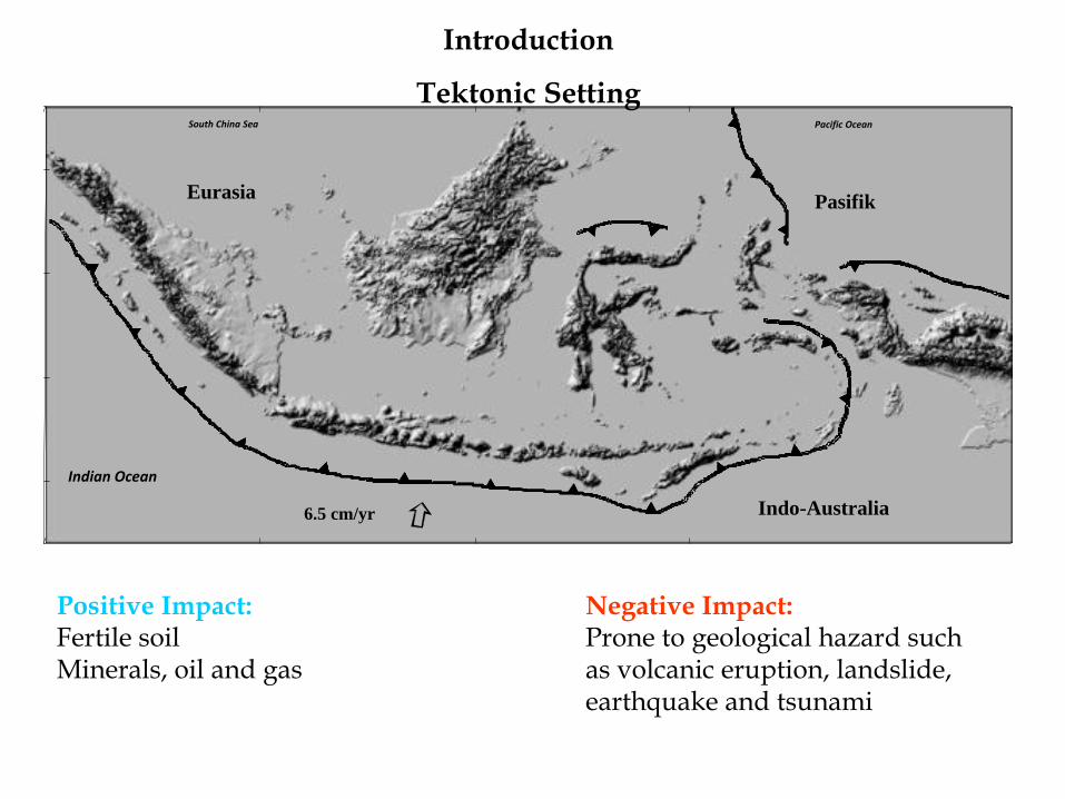
6.5 cm/yr Indo-Australia
Pasifik
Pacific Ocean South China Sea
Eurasia
Indian Ocean
Introduction
Tektonic Setting
Positive Impact: Fertile soil Minerals, oil and gas
Negative Impact: Prone to geological hazard such as volcanic eruption, landslide, earthquake and tsunami
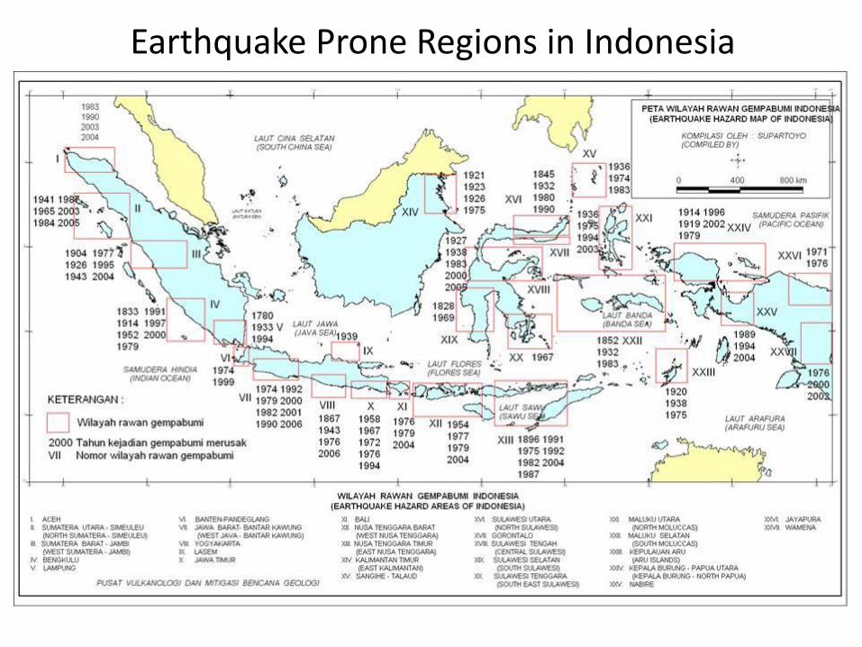
Earthquake Prone Regions in Indonesia
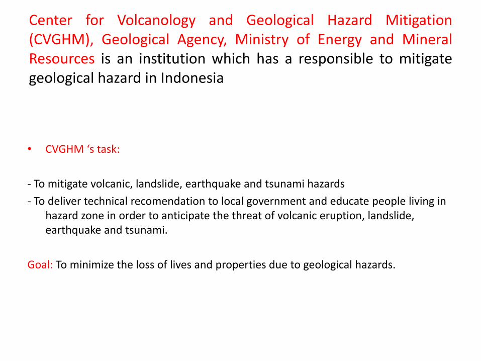
Center for Volcanology and Geological Hazard Mitigation (CVGHM), Geological Agency, Ministry of Energy and Mineral Resources is an institution which has a responsible to mitigate geological hazard in Indonesia
• CVGHM ‘s task:
- To mitigate volcanic, landslide, earthquake and tsunami hazards
- To deliver technical recomendation to local government and educate people living in hazard zone in order to anticipate the threat of volcanic eruption, landslide, earthquake and tsunami.
Goal: To minimize the loss of lives and properties due to geological hazards.
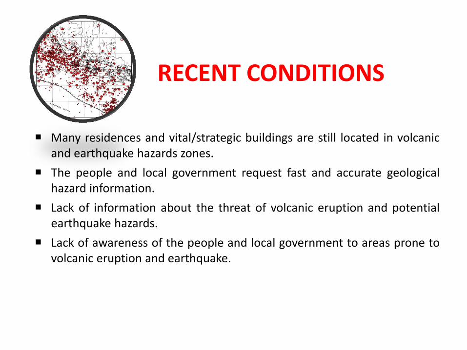
RECENT CONDITIONS
Many residences and vital/strategic buildings are still located in volcanic and earthquake hazards zones.
The people and local government request fast and accurate geological hazard information.
Lack of information about the threat of volcanic eruption and potential earthquake hazards.
Lack of awareness of the people and local government to areas prone to volcanic eruption and earthquake.
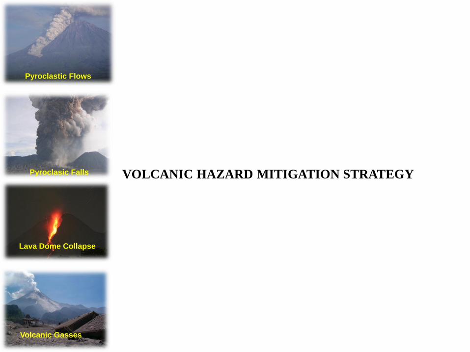
VOLCANIC HAZARD MITIGATION STRATEGY
Pyroclastic Flows
Lava Dome Collapse
Pyroclasic Falls
Volcanic Gasses
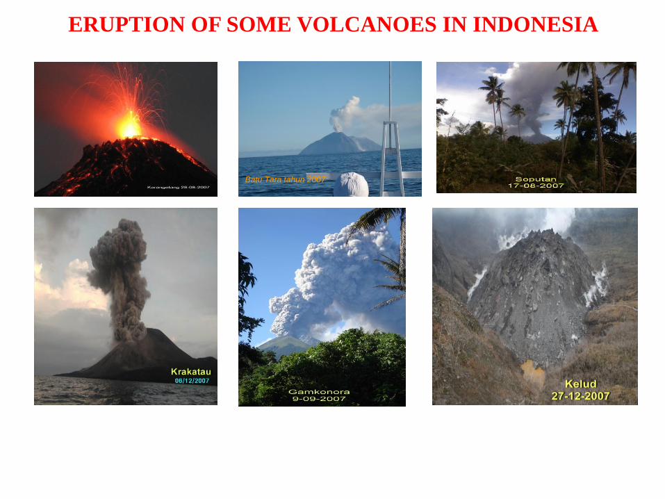
ERUPTION OF SOME VOLCANOES IN INDONESIA
Batu Tara tahun 2007
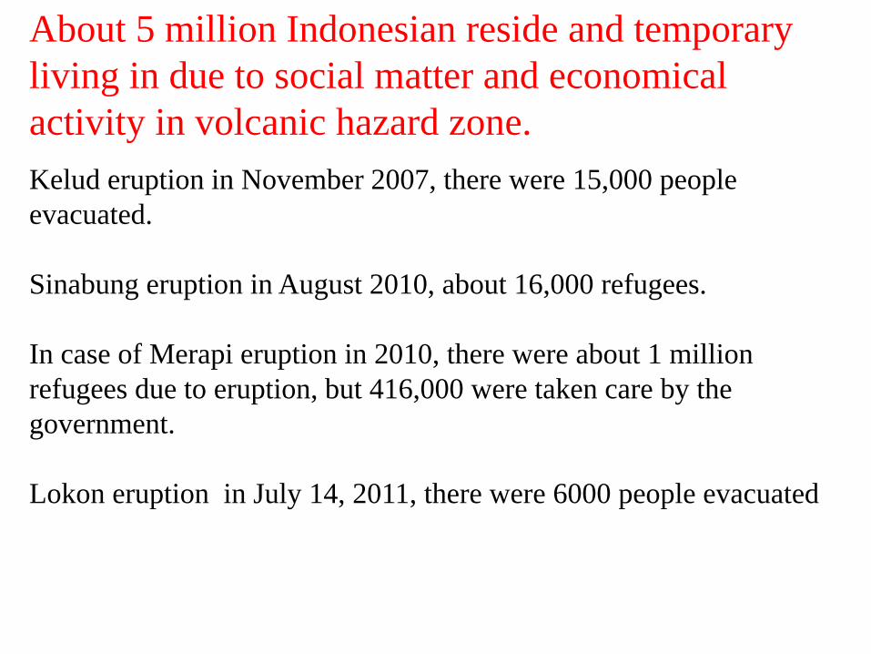
Kelud eruption in November 2007, there were 15,000 people
evacuated.
Sinabung eruption in August 2010, about 16,000 refugees.
In case of Merapi eruption in 2010, there were about 1 million
refugees due to eruption, but 416,000 were taken care by the
government.
Lokon eruption in July 14, 2011, there were 6000 people evacuated
About 5 million Indonesian reside and temporary
living in due to social matter and economical
activity in volcanic hazard zone.
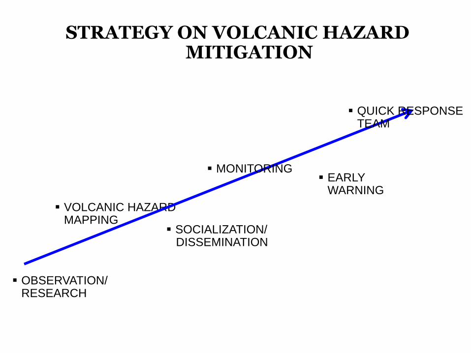
OBSERVATION/RESEARCH
STRATEGY ON VOLCANIC HAZARD MITIGATION
VOLCANIC HAZARD MAPPING
MONITORING EARLY
WARNING
SOCIALIZATION/ DISSEMINATION
QUICK RESPONSE TEAM
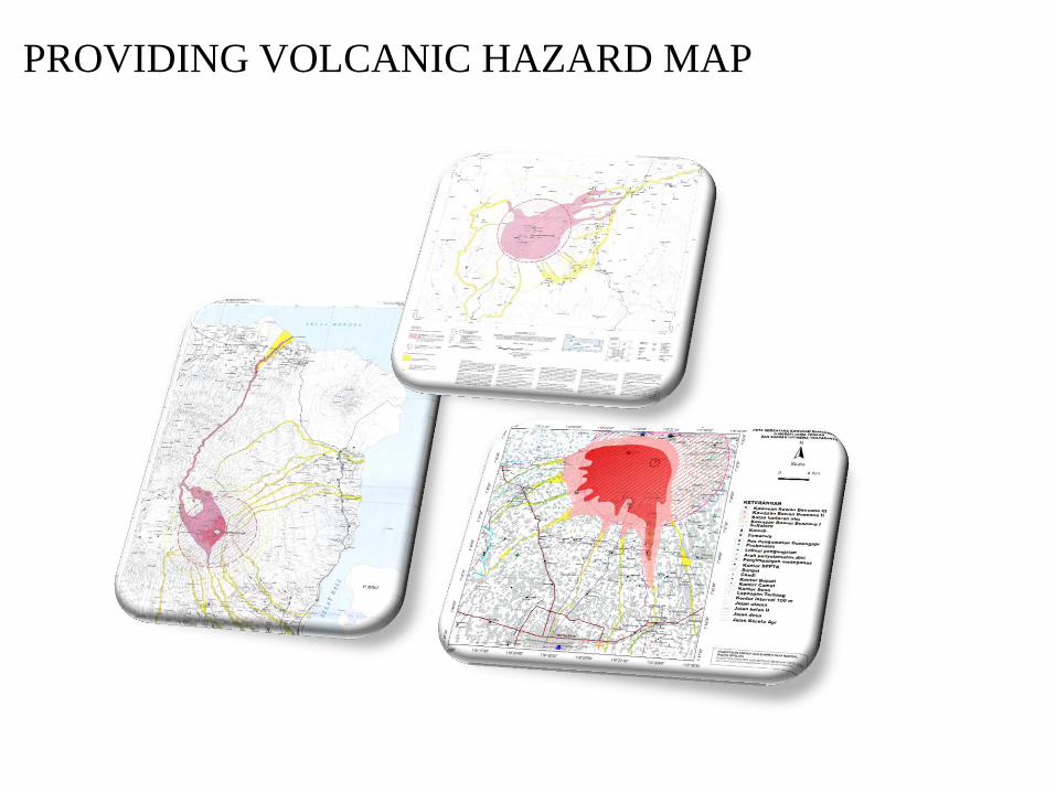
PROVIDING VOLCANIC HAZARD MAP
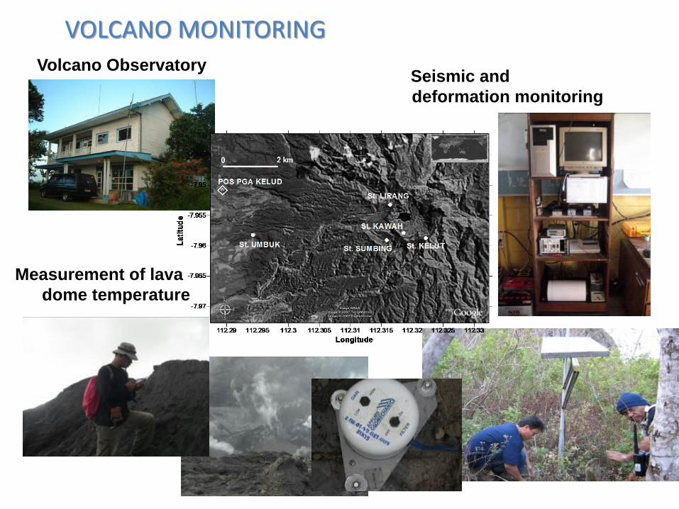
Volcano Observatory
Measurement of lava
dome temperature
Seismic and
deformation monitoring
VOLCANO MONITORING
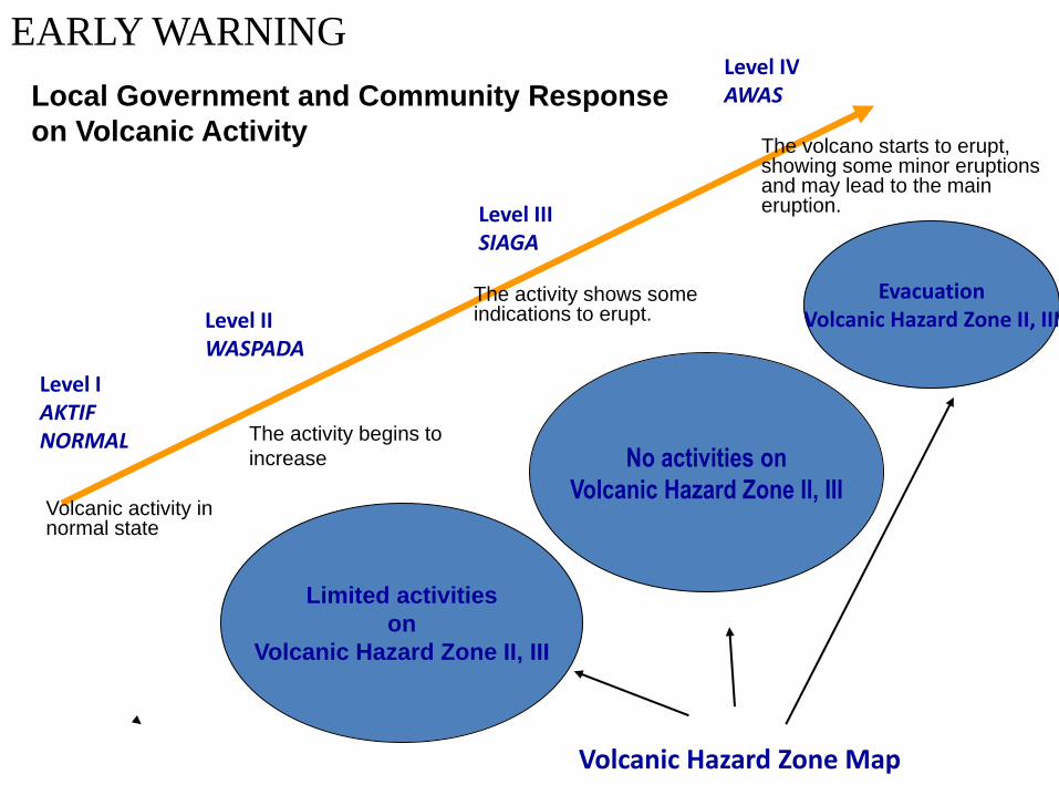
Level I AKTIF NORMAL
Level II WASPADA
Level III SIAGA
Level IV AWAS
Volcanic activity in normal state
The activity begins to
increase
The volcano starts to erupt, showing some minor eruptions and may lead to the main eruption.
Limited activities
on
Volcanic Hazard Zone II, III
No activities on
Volcanic Hazard Zone II, III
Evacuation Volcanic Hazard Zone II, III
Volcanic Hazard Zone Map
The activity shows some indications to erupt.
Local Government and Community Response
on Volcanic Activity
EARLY WARNING
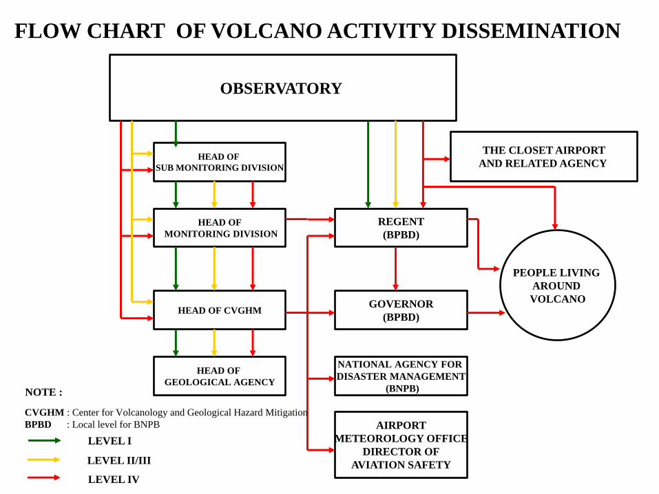
OBSERVATORY
HEAD OF
SUB MONITORING DIVISION
HEAD OF
MONITORING DIVISION
HEAD OF CVGHM
HEAD OF
GEOLOGICAL AGENCY
REGENT
(BPBD)
GOVERNOR
(BPBD)
NATIONAL AGENCY FOR
DISASTER MANAGEMENT
(BNPB)
AIRPORT
METEOROLOGY OFFICE
DIRECTOR OF
AVIATION SAFETY
THE CLOSET AIRPORT
AND RELATED AGENCY
PEOPLE LIVING
AROUND
VOLCANO
NOTE :
LEVEL I
LEVEL II/III
LEVEL IV
CVGHM : Center for Volcanology and Geological Hazard Mitigation
BPBD : Local level for BNPB
FLOW CHART OF VOLCANO ACTIVITY DISSEMINATION
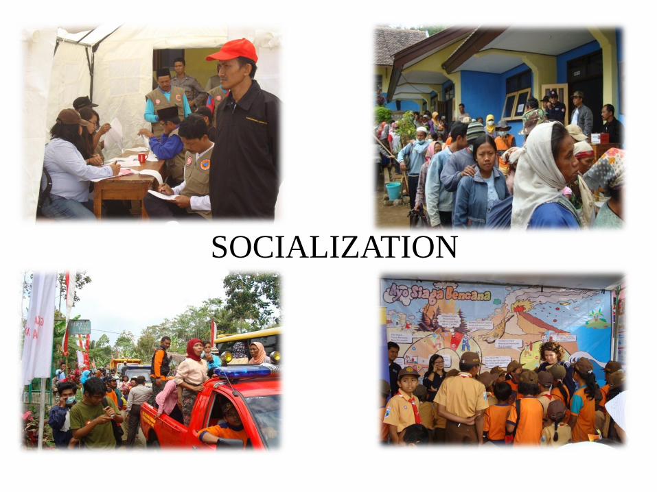
SOCIALIZATION
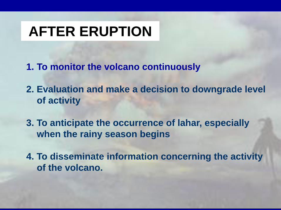
AFTER ERUPTION
1. To monitor the volcano continuously
2. Evaluation and make a decision to downgrade level
of activity
3. To anticipate the occurrence of lahar, especially
when the rainy season begins
4. To disseminate information concerning the activity
of the volcano.
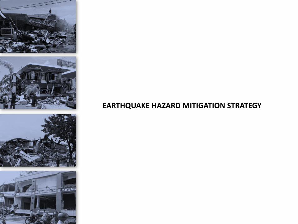
EARTHQUAKE HAZARD MITIGATION STRATEGY
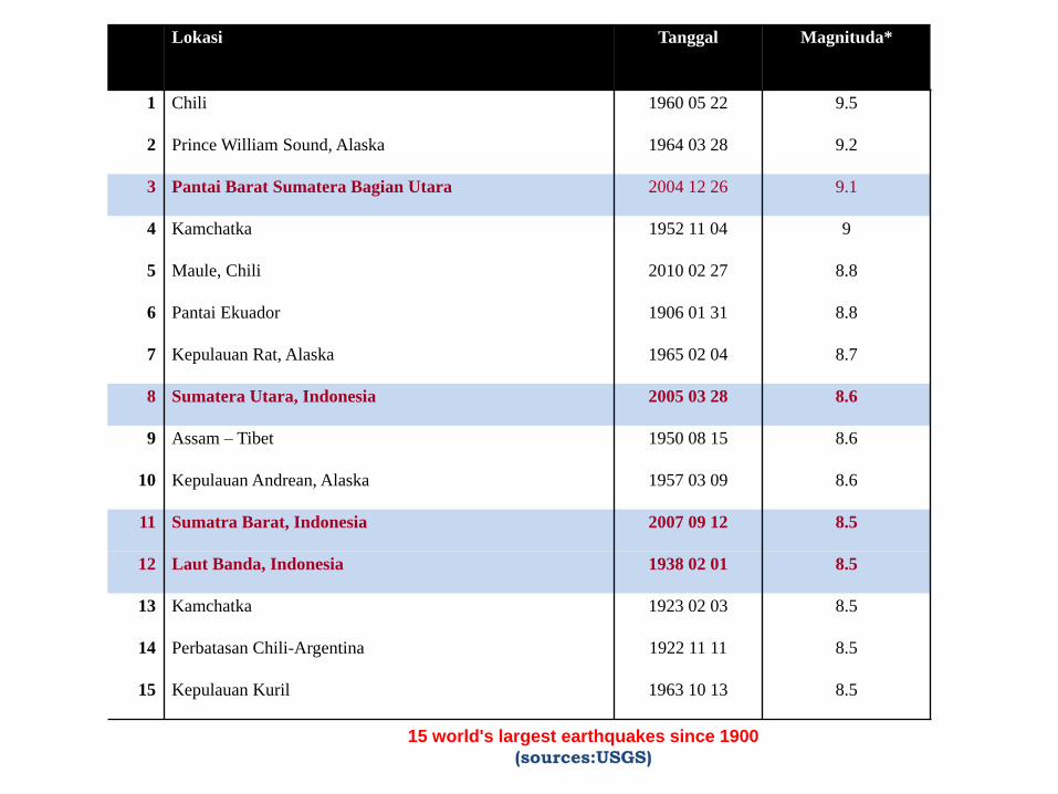
Lokasi Tanggal Magnituda*
1 Chili 1960 05 22 9.5
2 Prince William Sound, Alaska 1964 03 28 9.2
3 Pantai Barat Sumatera Bagian Utara 2004 12 26 9.1
4 Kamchatka 1952 11 04 9
5 Maule, Chili 2010 02 27 8.8
6 Pantai Ekuador 1906 01 31 8.8
7 Kepulauan Rat, Alaska 1965 02 04 8.7
8 Sumatera Utara, Indonesia 2005 03 28 8.6
9 Assam – Tibet 1950 08 15 8.6
10 Kepulauan Andrean, Alaska 1957 03 09 8.6
11 Sumatra Barat, Indonesia 2007 09 12 8.5
12 Laut Banda, Indonesia 1938 02 01 8.5
13 Kamchatka 1923 02 03 8.5
14 Perbatasan Chili-Argentina 1922 11 11 8.5
15 Kepulauan Kuril 1963 10 13 8.5
15 world's largest earthquakes since 1900
(sources:USGS)
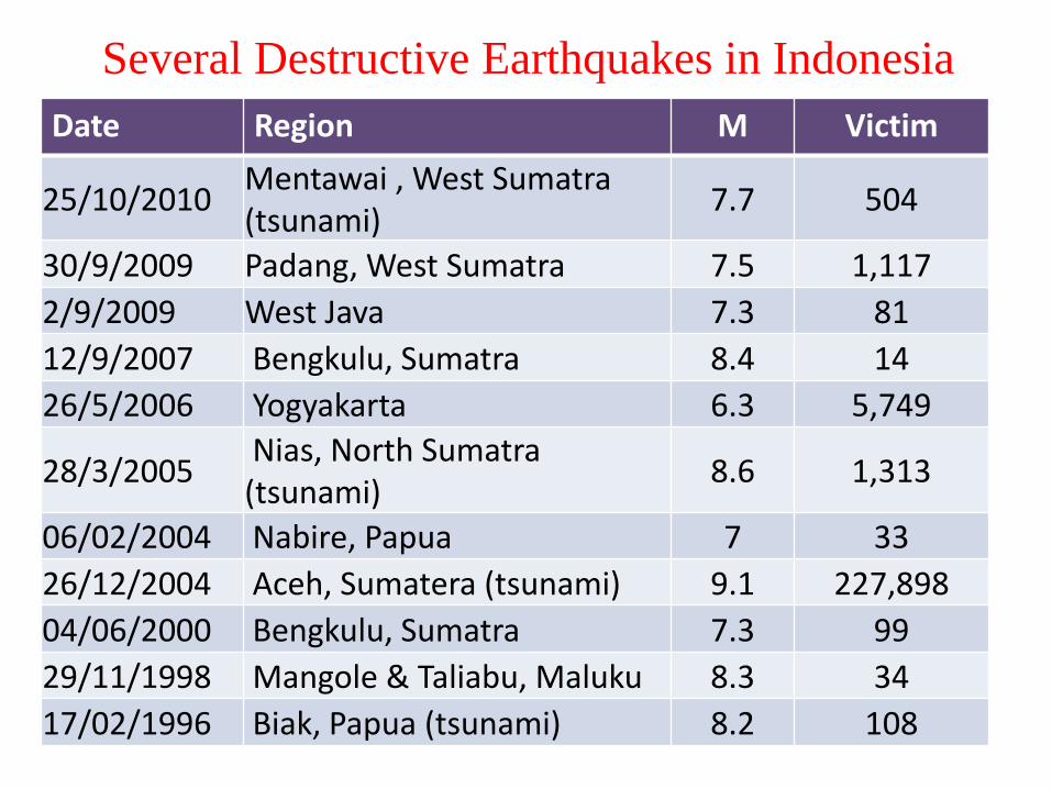
Several Destructive Earthquakes in Indonesia
Date Region M Victim
25/10/2010 Mentawai , West Sumatra (tsunami)
7.7 504
30/9/2009 Padang, West Sumatra 7.5 1,117
2/9/2009 West Java 7.3 81
12/9/2007 Bengkulu, Sumatra 8.4 14
26/5/2006 Yogyakarta 6.3 5,749
28/3/2005 Nias, North Sumatra (tsunami)
8.6 1,313
06/02/2004 Nabire, Papua 7 33
26/12/2004 Aceh, Sumatera (tsunami) 9.1 227,898
04/06/2000 Bengkulu, Sumatra 7.3 99
29/11/1998 Mangole & Taliabu, Maluku 8.3 34
17/02/1996 Biak, Papua (tsunami) 8.2 108
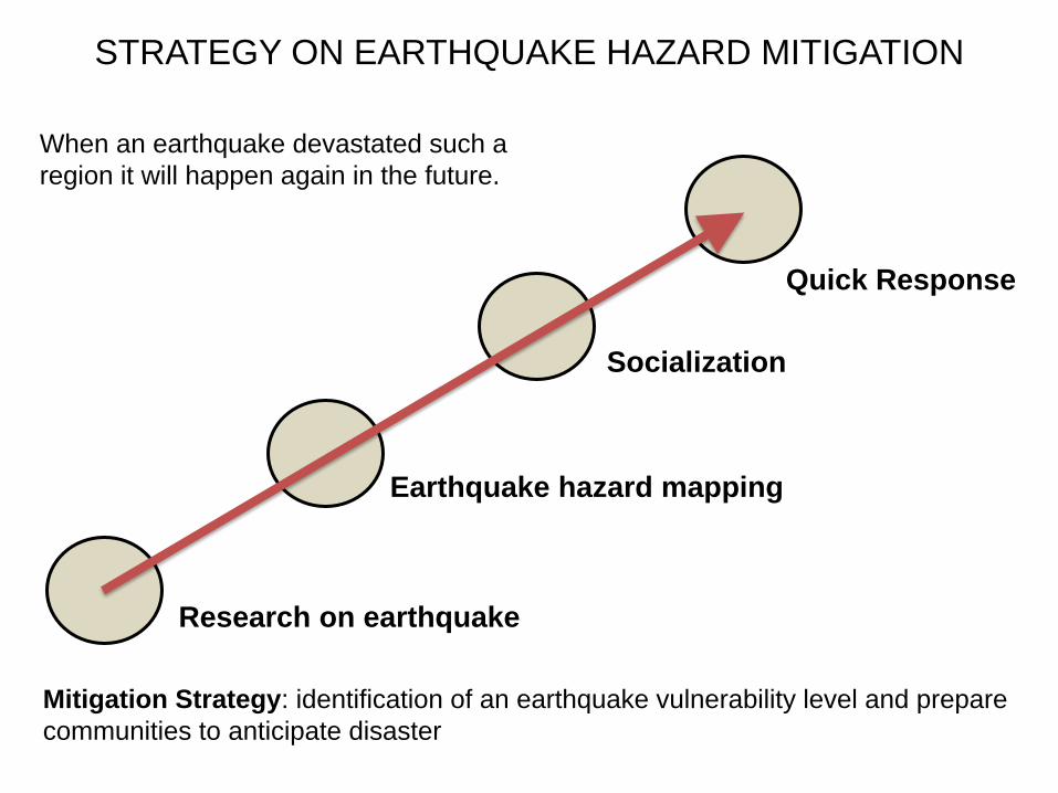
Earthquake hazard mapping
Research on earthquake
Socialization
Quick Response
Mitigation Strategy: identification of an earthquake vulnerability level and prepare
communities to anticipate disaster
STRATEGY ON EARTHQUAKE HAZARD MITIGATION
When an earthquake devastated such a
region it will happen again in the future.
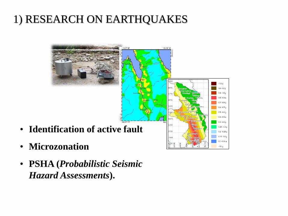
1) RESEARCH ON EARTHQUAKES
• Identification of active fault
• Microzonation
• PSHA (Probabilistic Seismic
Hazard Assessments).
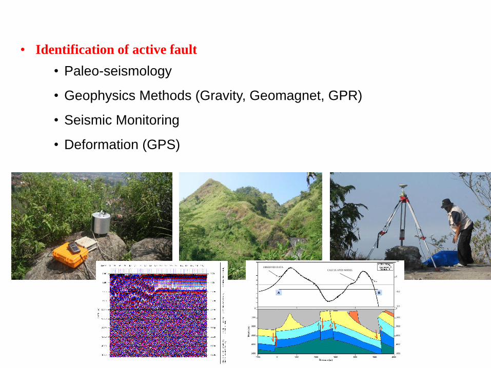
• Identification of active fault
• Paleo-seismology
• Geophysics Methods (Gravity, Geomagnet, GPR)
• Seismic Monitoring
• Deformation (GPS)
Gb.7. MODEL 2 DIMENSI PENAMPANG MAGNETIK A-B
OBSERVED DATA
CALCULATED MODEL
A B
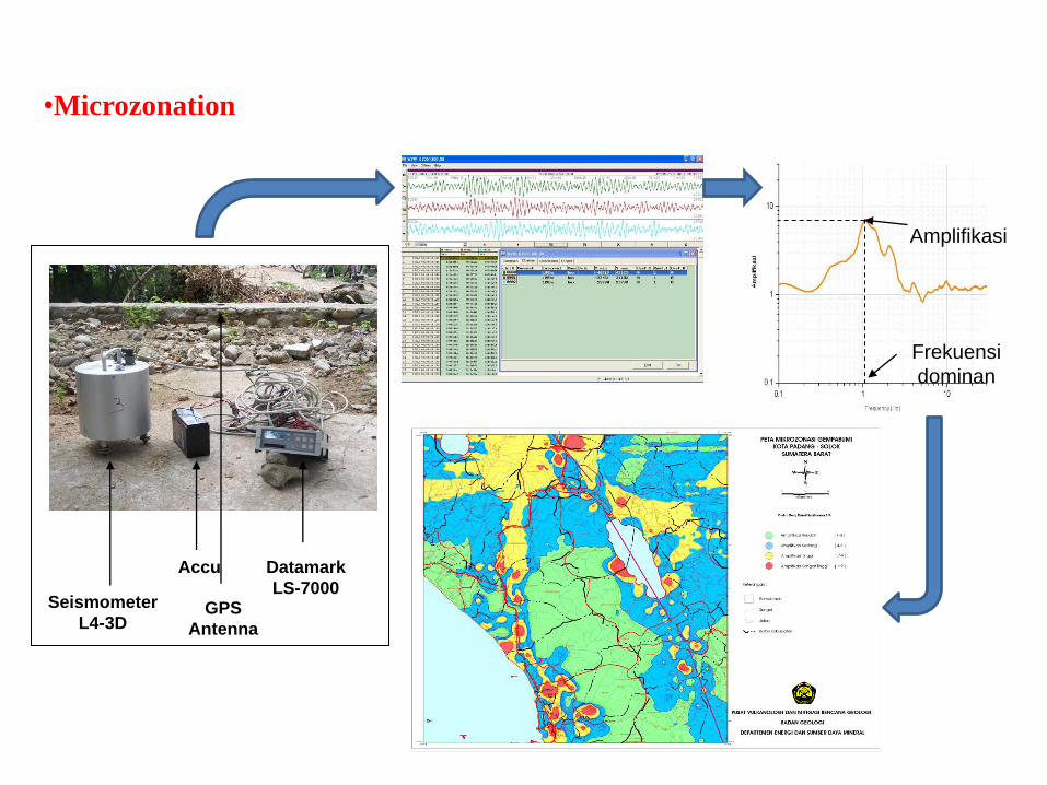
Frekuensi
dominan
Amplifikasi
•Microzonation
Seismometer
L4-3D
Accu
GPS
Antenna
Datamark
LS-7000
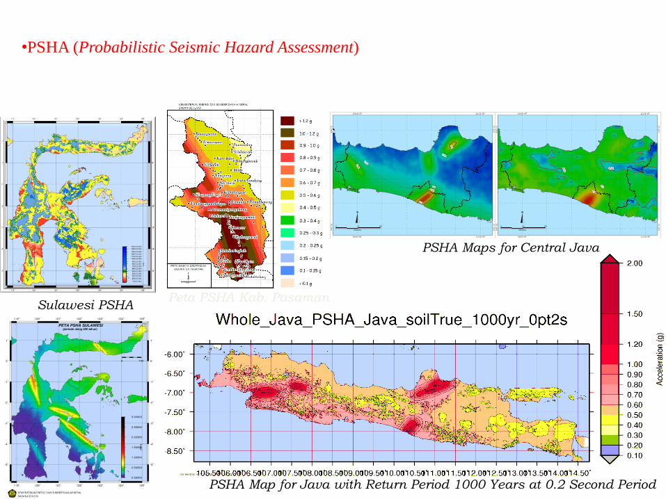
PSHA Map for Java with Return Period 1000 Years at 0.2 Second Period
•PSHA (Probabilistic Seismic Hazard Assessment)
109.00° BT
109.00° BT
8.5
0°
LS
6.5
0°
LS
kilometer
0 50 100
111.50° BT
111.50° BT
6.5
0°
LS
8.5
0°
LS
0.350.350.350.350.350.350.350.350.350.350.350.350.350.350.350.350.350.350.350.350.350.350.350.350.350.350.350.350.350.350.350.350.350.350.350.350.350.350.350.350.350.350.350.350.350.350.350.350.35
0.350.350.350.350.350.350.350.350.350.350.350.350.350.350.350.350.350.350.350.350.350.350.350.350.350.350.350.350.350.350.350.350.350.350.350.350.350.350.350.350.350.350.350.350.350.350.350.350.35
0.30.30.30.30.30.30.30.30.30.30.30.30.30.30.30.30.30.30.30.30.30.30.30.30.30.30.30.30.30.30.30.30.30.30.30.30.30.30.30.30.30.30.30.30.30.30.30.30.3
0.40.40.40.40.40.40.40.40.40.40.40.40.40.40.40.40.40.40.40.40.40.40.40.40.40.40.40.40.40.40.40.40.40.40.40.40.40.40.40.40.40.40.40.40.40.40.40.40.4
0.450.450.450.450.450.450.450.450.450.450.450.450.450.450.450.450.450.450.450.450.450.450.450.450.450.450.450.450.450.450.450.450.450.450.450.450.450.450.450.450.450.450.450.450.450.450.450.450.45
0.5
0.5
0.5
0.5
0.5
0.5
0.5
0.5
0.5
0.5
0.5
0.5
0.5
0.5
0.5
0.5
0.5
0.5
0.5
0.5
0.5
0.5
0.5
0.5
0.5
0.5
0.5
0.5
0.5
0.5
0.5
0.5
0.5
0.5
0.5
0.5
0.5
0.5
0.5
0.5
0.5
0.5
0.5
0.5
0.5
0.5
0.5
0.5
0.5
0.550.550.550.550.550.550.550.550.550.550.550.550.550.550.550.550.550.550.550.550.550.550.550.550.550.550.550.550.550.550.550.550.550.550.550.550.550.550.550.550.550.550.550.550.550.550.550.550.55
0.70.70.70.70.70.70.70.70.70.70.70.70.70.70.70.70.70.70.70.70.70.70.70.70.70.70.70.70.70.70.70.70.70.70.70.70.70.70.70.70.70.70.70.70.70.70.70.70.7
109.00° BT
109.00° BT
8.5
0°
LS
6.5
0°
LS
kilometer
0 50 100
111.50° BT
111.50° BT
6.5
0°
LS
8.5
0°
LS
0.250.250.250.250.250.250.250.250.250.250.250.250.250.250.250.250.250.250.250.250.250.250.250.250.250.250.250.250.250.250.250.250.250.250.250.250.250.250.250.250.250.250.250.250.250.250.250.250.25
0.2
50.2
50.2
50.2
50.2
50.2
50.2
50.2
50.2
50.2
50.2
50.2
50.2
50.2
50.2
50.2
50.2
50.2
50.2
50.2
50.2
50.2
50.2
50.2
50.2
50.2
50.2
50.2
50.2
50.2
50.2
50.2
50.2
50.2
50.2
50.2
50.2
50.2
50.2
50.2
50.2
50.2
50.2
50.2
50.2
50.2
50.2
50.2
50.2
5
0.30.30.30.30.30.30.30.30.30.30.30.30.30.30.30.30.30.30.30.30.30.30.30.30.30.30.30.30.30.30.30.30.30.30.30.30.30.30.30.30.30.30.30.30.30.30.30.30.3
0.40.40.40.40.40.40.40.40.40.40.40.40.40.40.40.40.40.40.40.40.40.40.40.40.40.40.40.40.40.40.40.40.40.40.40.40.40.40.40.40.40.40.40.40.40.40.40.40.4
PSHA Maps for Central Java
Sulawesi PSHA Peta PSHA Kab. Pasaman
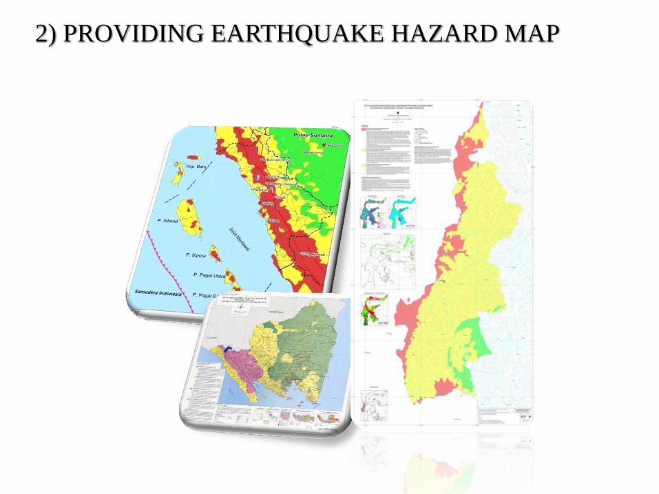
2) PROVIDING EARTHQUAKE HAZARD MAP

Very Low
Low
High What Community and Local Government do in Earthquake Hazard Area?
MMI > VIII
No problem to build facilities
and residential infrastructure
Potential to earthquake
The building should
be earthquake resistant
If we have to build
vital and strategic building
The building must be
earthquake resistant
EARTHQUAKE HAZARD MAP
MMI VII - VII
MMI V - VII
Free to build facilities and
residential infrastructure with earthquake shock-resistant
Moderate
MMI < V

Direct Socialization
Contingency Planning
Leaflet dan Booklet
Exhibition
3) SOCIALIZATION The purpose of socialization is to increase knowledge and awareness of the people living around the prone area to earthquakes.
Coordination with the local governments and related agencies is carried out to improve the effectiveness of the earthquake hazard mitigation
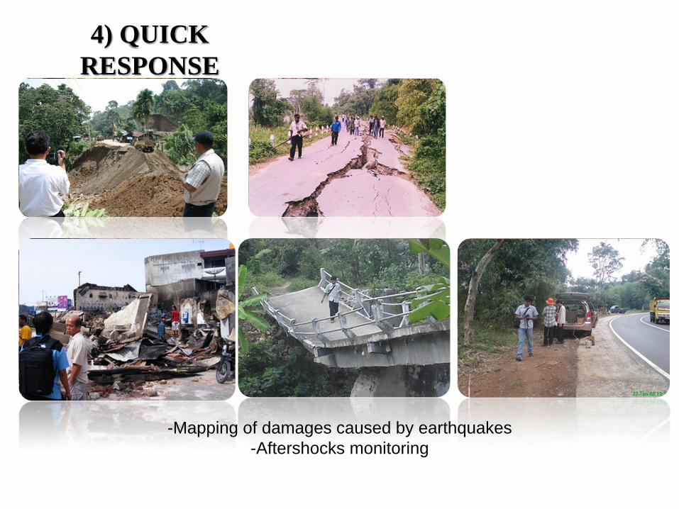
4) QUICK
RESPONSE
-Mapping of damages caused by earthquakes
-Aftershocks monitoring

JALAN
KETERANGAN
TITIK KERUSAKAN
a. kerusakan berat
b. kerusakan ringan
SUNGAI
200 10
kilometers
REL KERETAAPI
ba
PETA TITIK KERUSAKAN GEMPABUMI PADANG
HASIL PEMERIKSAAN PER 9 OKTOBER 2009
TITIK LONGSOR
BATAS KABUPATEN
DEPARTEMEN ENERGI DAN SUMBERDAYA MINERAL
BADAN GEOLOGI
PUSAT VULKANOLOGI DAN MITIGASI BENCANA GEOLOGI
0.2
5°L
S
99.88°BT 100.70°BT
0.2
5°L
S
1.4
0°L
S
99.88°BT 100.70°BT
1.4
0°L
S
D. TalangD. TalangD. TalangD. TalangD. TalangD. TalangD. TalangD. TalangD. Talang
B. Airmasang
B. Airmasang
B. Airmasang
B. Airmasang
B. Airmasang
B. Airmasang
B. Airmasang
B. Airmasang
B. Airmasang
PD ALAIPD ALAIPD ALAIPD ALAIPD ALAIPD ALAIPD ALAIPD ALAIPD ALAI
T24T24T24T24T24T24T24T24T24
T06T06T06T06T06T06T06T06T06
SB09SB09SB09SB09SB09SB09SB09SB09SB09
SB03SB03SB03SB03SB03SB03SB03SB03SB03
SB05SB05SB05SB05SB05SB05SB05SB05SB05SB16SB16SB16SB16SB16SB16SB16SB16SB16
K15K15K15K15K15K15K15K15K15
T56T56T56T56T56T56T56T56T56
PayakumbuhPayakumbuhPayakumbuhPayakumbuhPayakumbuhPayakumbuhPayakumbuhPayakumbuhPayakumbuh
PainanPainanPainanPainanPainanPainanPainanPainanPainan
D. ManinjauD. ManinjauD. ManinjauD. ManinjauD. ManinjauD. ManinjauD. ManinjauD. ManinjauD. Maninjau
D. SingkarakD. SingkarakD. SingkarakD. SingkarakD. SingkarakD. SingkarakD. SingkarakD. SingkarakD. Singkarak
Air Tar
usan
Air Tar
usan
Air Tar
usan
Air Tar
usan
Air Tar
usan
Air Tar
usan
Air Tar
usan
Air Tar
usan
Air Tar
usan
B. Antokan
B. Antokan
B. Antokan
B. Antokan
B. Antokan
B. Antokan
B. Antokan
B. Antokan
B. Antokan
B. A
gam
B. A
gam
B. A
gam
B. A
gam
B. A
gam
B. A
gam
B. A
gam
B. A
gam
B. A
gam
A. M
unti
A. M
unti
A. M
unti
A. M
unti
A. M
unti
A. M
unti
A. M
unti
A. M
unti
A. M
unti
B. A
nai
B. A
nai
B. A
nai
B. A
nai
B. A
nai
B. A
nai
B. A
nai
B. A
nai
B. A
nai
S. BagoS. BagoS. BagoS. BagoS. BagoS. BagoS. BagoS. BagoS. Bago
B. S
inam
ar
B. S
inam
ar
B. S
inam
ar
B. S
inam
ar
B. S
inam
ar
B. S
inam
ar
B. S
inam
ar
B. S
inam
ar
B. S
inam
ar
B. S
elo
B. S
elo
B. S
elo
B. S
elo
B. S
elo
B. S
elo
B. S
elo
B. S
elo
B. S
elo
B. Masangkiri
B. Masangkiri
B. Masangkiri
B. Masangkiri
B. Masangkiri
B. Masangkiri
B. Masangkiri
B. Masangkiri
B. Masangkiri
S. TikuS. TikuS. TikuS. TikuS. TikuS. TikuS. TikuS. TikuS. Tiku
B. Air Tarusan
B. Air Tarusan
B. Air Tarusan
B. Air Tarusan
B. Air Tarusan
B. Air Tarusan
B. Air Tarusan
B. Air Tarusan
B. Air Tarusan
B. UmbilianB. UmbilianB. UmbilianB. UmbilianB. UmbilianB. UmbilianB. UmbilianB. UmbilianB. Umbilian
B. S
um
ani
B. S
um
ani
B. S
um
ani
B. S
um
ani
B. S
um
ani
B. S
um
ani
B. S
um
ani
B. S
um
ani
B. S
um
ani
B. BunutB. BunutB. BunutB. BunutB. BunutB. BunutB. BunutB. BunutB. Bunut
B. Sianok
B. Sianok
B. Sianok
B. SianokB. Sianok
B. Sianok
B. Sianok
B. Sianok
B. Sianok
KM 32.5KM 32.5KM 32.5KM 32.5KM 32.5KM 32.5KM 32.5KM 32.5KM 32.5
ROCK FALLROCK FALLROCK FALLROCK FALLROCK FALLROCK FALLROCK FALLROCK FALLROCK FALL
BKTTG-MANINJAUBKTTG-MANINJAUBKTTG-MANINJAUBKTTG-MANINJAUBKTTG-MANINJAUBKTTG-MANINJAUBKTTG-MANINJAUBKTTG-MANINJAUBKTTG-MANINJAU
PULO AIRPULO AIRPULO AIRPULO AIRPULO AIRPULO AIRPULO AIRPULO AIRPULO AIR
JR. PANDANJR. PANDANJR. PANDANJR. PANDANJR. PANDANJR. PANDANJR. PANDANJR. PANDANJR. PANDAN
KOTO TIMURKOTO TIMURKOTO TIMURKOTO TIMURKOTO TIMURKOTO TIMURKOTO TIMURKOTO TIMURKOTO TIMUR
PALEMBAYANPALEMBAYANPALEMBAYANPALEMBAYANPALEMBAYANPALEMBAYANPALEMBAYANPALEMBAYANPALEMBAYAN
TIRAM ULAKANTIRAM ULAKANTIRAM ULAKANTIRAM ULAKANTIRAM ULAKANTIRAM ULAKANTIRAM ULAKANTIRAM ULAKANTIRAM ULAKAN
SB12SB12SB12SB12SB12SB12SB12SB12SB12
T03T03T03T03T03T03T03T03T03
T09T09T09T09T09T09T09T09T09
T11T11T11T11T11T11T11T11T11
T13T13T13T13T13T13T13T13T13
T17T17T17T17T17T17T17T17T17
T20T20T20T20T20T20T20T20T20
T21T21T21T21T21T21T21T21T21T25T25T25T25T25T25T25T25T25
SB17SB17SB17SB17SB17SB17SB17SB17SB17
T40T40T40T40T40T40T40T40T40
T49T49T49T49T49T49T49T49T49
T55T55T55T55T55T55T55T55T55
K01K01K01K01K01K01K01K01K01
K03K03K03K03K03K03K03K03K03
K06K06K06K06K06K06K06K06K06
PalembaianPalembaianPalembaianPalembaianPalembaianPalembaianPalembaianPalembaianPalembaian
SicincinSicincinSicincinSicincinSicincinSicincinSicincinSicincinSicincin
KotatuaKotatuaKotatuaKotatuaKotatuaKotatuaKotatuaKotatuaKotatua
Paadang PanjangPaadang PanjangPaadang PanjangPaadang PanjangPaadang PanjangPaadang PanjangPaadang PanjangPaadang PanjangPaadang Panjang
SulikiSulikiSulikiSulikiSulikiSulikiSulikiSulikiSuliki
TarusanTarusanTarusanTarusanTarusanTarusanTarusanTarusanTarusan
SumaniSumaniSumaniSumaniSumaniSumaniSumaniSumaniSumani
CupakCupakCupakCupakCupakCupakCupakCupakCupak
SolokSolokSolokSolokSolokSolokSolokSolokSolok
Palembayan, Agam
Tanjungsani, Agam
Pulo Koto
Pulo Koto
Cumanak
Padang Earthquake, September 30, 2009
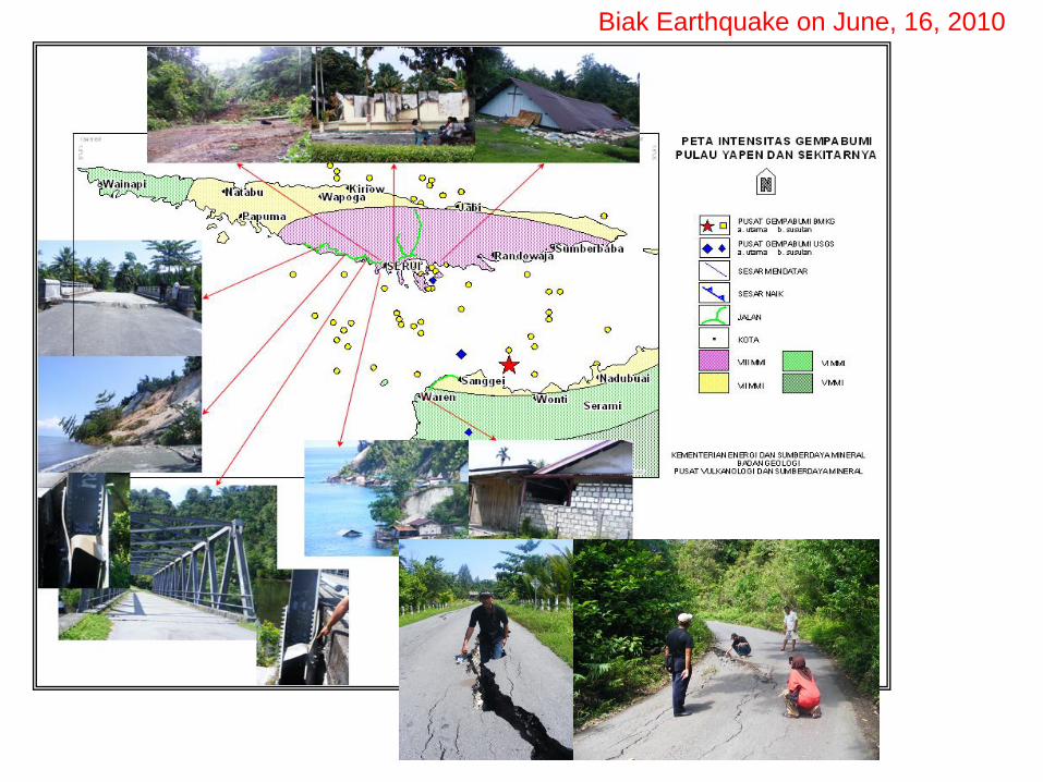
Biak Earthquake on June, 16, 2010

P. Pagai Utara
P. Pagai Selatan
-2°
29
' 3
2.1
5"
-3°
22
' 36
.65
"
99° 54' 24.06"
0 12.5
100° 39' 33.5"
25 Km
Betu Monga
Sikakap
Malakopak
Silaut
SindangTanjuang Sari
Tanjung Makmur
UPT Silaut IV
Makalo
HUTAN
Matobek
Nem-nem Leu
Bulasat
Sinaka
Taikako
Saumanganyak
Silabu
Bosua
Talang Kemuning
Dusun Baru Lempur
Semundam
Dusun Sibak
Padang Gading
Retak Mudik
Pasar Bantal
Air Berau
Ponndok Baru
Air DikitDusun Baru
Suka Maju
Sungai Jerinjing
Pondok Baru
Setia Budi
Ujung Pandang
Ds Baru Pelokan
Talang Petai
Pauh Terenja
Tsunami Mentawai
October 25, 2010
triggered by earthquake 7.7 Mw / 7.2 SR
quick response team
SUMMARY
• The government of Indonesia awares about the disaster and the
impact owing to volcanic eruption and earthquake. As a
consequence the Law No. 24/2007 concerning Disaster Management
is established. It has change the paradigm of hazard mitigation by
focusing on pre-disaster phase efforts such as: intensive volcano
monitoring, providing hazard maps on volcano and earthquake and
socialization.
• Region prone to volcanic eruption and earthquakes hazard does not
mean not worthy to live in, but in the spatial planning it should refer
to volcanic and earthquake hazard maps as well as risk analysis.