Embed Size (px)
Citation preview
Earthquake Hazard in the Heart of the HomelandEvidence that earthquakes threaten theMississippi, Ohio, and Wabash River valleys of the Central United Statesabounds. In fact, one of the largest histori-cal earthquakes to strike the continentalUnited States occurred in the winter of1811–1812 along the New Madrid seismiczone, which stretches from just west ofMemphis, Tennessee, into southernIllinois. Several times in the past century,moderate earthquakes have been widelyfelt in southernIllinois and south-western Indiana.Geologic evidencefor prehistoric earth-quakes throughoutthe region has beenmounting since thelate 1970s. But howsignificant is thethreat? How likelyare large earth-quakes and, moreimportantly, what isthe chance that theshaking they causewill be damaging?
Like many naturalphenomena, how anearthquake affectspeople depends onmany factors.Studying earth-quakes is especiallychallenging becausethey happen infre-quently and without
U.S. Department of the InteriorU.S. Geological Survey
U.S. Geological Survey Fact Sheet FS-131-02October 2002
“. . . researchduring the last 15 yearshas led to newunderstanding,particularlywith respect to earthquakes in the New Madridseismic zone.”
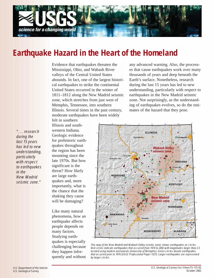
This map of the New Madrid and Wabash Valley seismic zones shows earthquakes as circles.Red circles indicate earthquakes that occurred from 1974 to 2002 with magnitudes larger than 2.5located using modern instruments (University of Memphis). Green circles denote earthquakesthat occurred prior to 1974 (USGS Professional Paper 1527). Larger earthquakes are representedby larger circles.
any advanced warning. Also, the process-es that cause earthquakes work over manythousands of years and deep beneath theEarth’s surface. Nonetheless, researchduring the last 15 years has led to newunderstanding, particularly with respect toearthquakes in the New Madrid seismiczone. Not surprisingly, as the understand-ing of earthquakes evolves, so do the esti-mates of the hazard that they pose.

The U.S. Geological Surveyshaking-hazard maps for
the United States are basedon current information
about the rate at whichearthquakes occur in differ-
ent areas and on how farstrong shaking extends
from earthquake sources.Colors on this particular
map show the levels of hor-izontal shaking that have a
1-in-50 chance of beingexceeded in a 50-year peri-od. Shaking is expressed as
a percentage of g (g is theacceleration of a falling
object due to gravity).
level of shaking being exceeded in 50years, while a home builder is more like-ly to use a map with a 10-percent chanceof being exceeded in 50 years.
Earthquake hazards in the CentralUnited States
One of the most prominent features onthe national seismic hazard maps is azone of high hazard surrounding the NewMadrid region in the Central UnitedStates. The hazard in this region is ashigh as for places in California, despite alower level of modern-day earthquakeactivity. Scientists have designated this asa high hazard region based on studies ofburied sand blow deposits within theMississippi River Valley. Sand blowdeposits are believed to be the byproductof strong ground shaking associated withlarge earthquakes (see box “Digging upthe past”). These deposits have been
dated at about A.D.900 and A.D. 1450and suggest that majorearthquakes (magni-tude 7 or greater)reoccur in the regionapproximately every500 years, with thelast sequence being in1811-1812.
A five hundred-yearinterval between mag-nitude 7 or greater
earthquakes is much more frequent thanexpected, given the current level of earth-quake activity in the New Madrid region.Elsewhere scientists use the frequency ofsmall and moderate earthquakes to esti-mate the likelihood of larger events, butin the New Madrid region, this rule ofthumb does not appear to apply. As any-one who lives in the New Madrid regionwould testify, earthquakes are felt in theNew Madrid region much less frequentlythan in California, despite the similar
Estimating earthquake hazards
Earthquake hazard refers to the conse-quences of an earthquake that may disruptthe normal activities of people or causethem loss. Most hazard arises fromground shaking caused by waves thatemanate from the abrupt fault movementduring an earthquake. Seismic hazardmaps depict the ground shaking that isexpected to be exceeded at a selectedprobability (or chance) over a specifictime period. Estimates of this “probabilis-tic” ground shaking, or hazard, at anygiven location must account for many fac-tors including the possible shaking fromall likely earthquakes and the types ofrocks and soil in the region.
The USGS produces earthquake (seismic)hazard maps on a national scale. Hazardmaps are also now produced in selecturban areas. At either scale there are a
suite of maps for different probabilitiesand time periods; the choice of which touse depends upon the needs of the user.Builders of a dam, for instance, mightwant to consider longer periods of timeand lower likelihood that shaking will beexceeded than a home builder. This isbecause a dam is built to have a longerlife, and damage to it would have agreater impact on society. The bridgedesigner would thus use a hazard mapwith, say, a 2-percent chance of a given
%g
64 +
48-64
32-4816-328-16
4-80-4
Highest hazard
Lowest hazard

To figure out the earthquake hazard of an area, scientists need toknow how often the largest earthquakes occur. Unfortunately (froma scientific perspective), the time between major earthquakes ismuch longer than the time period for which we have modern instru-mental measurements or even historical accounts of earthquakes.Fortunately, scientists have found a sufficiently long record of pastearthquakes that is preserved in the rock and soil beneath our feet.The unraveling of this record is the realm of a field called “paleo-seismology.” In the Central United States, abundant sand blows arestudied by paleoseismologists. These patches of sand erupt ontothe ground when waves from a large earthquake pass through wet,loose sand. The water pressure increases, forcing the sand grains
apart until the sand starts tobehave like a liquid (“liquefies”), and a slurry of sand and water isforced to the ground surface. If the age of material buried by theerupted sand can be determined (such as Native American artifactsor plant remains), then we know the earthquake must have occurredafter this date. If the sand blow is itself buried by something that canbe dated, then we know the earthquake happened before this date.We now know that series of large earthquakes, similar in size andlocation to those in 1811–1812, have occurred twice in the past 1,200years, once between A.D. 800 and 1000, and again between A.D.1300 and 1600, or about one every 500 years.
Digging up the past
Buried sand blow
Artifacts
Charcoal, sticks, etc.
Buried prehistoric sand blow
Modern sand blow
Liquefied sand
Earthquake Waves
Silt and clay layers
Filled fissure(sand dike)
(after Sims and Garvin, 1995)
level of hazard. Additionally, the largeearthquakes in the New Madrid regionseem to happen much more frequentlythan predicted from extremely accuratesatellite-based measurements of grounddeformation. These measurements showthat the Earth’s crust is being deformed,or strained, extremely slowly, if at all.This is in contrast to California, where therate of major earthquakes is predictablebased on measured deformation.
Far from a plate boundary
Why does the Central United States havemore large earthquakes than expected?Why is it so different from California?The answers to these questions are stillunknown, but scientists now questionwhether there might be fundamental dif-ferences between the geologic processesat, and away from, plate boundaries. TheNew Madrid region is far away from any
On this shaded topographic relief map, the New Madrid seismic zone is shown by a star,and the boundaries of the North American and surrounding plates are indicated by redlines. Mountainous regions tend to occur near plate boundaries, resulting from themotions between plates. The nearest plate boundary to the New Madrid seismic zone ismany thousands of kilometers away.
tectonic plate boundary, and thus applyingwhat has been learned from studies ofplaces like the San Andreas system inCalifornia to the New Madrid region maynot be appropriate.

For more information,contact:
Joan Gomberg Eugene SchweigU.S. Geological Survey3876 Central AvenueSuite 2Memphis, TN [email protected]
Graphic design and layout by Pamela Svendsen Detra
In much the same way as meteorologists forecast rain, earth scientistspresent forecasts of earthquakes as the chance or “probability” of anearthquake occurring in a specific time interval. Although we are stilllearning why the New Madrid region experiences large earthquakes,research during the last 15 years in the Central United States has led tonew discoveries that, not surprisingly, have led to new estimates of thelikelihood of damaging earthquakes. It is generally accepted that earth-quakes can be expected in the future as frequently as in the recent past.We determine how often earthquakes reoccur from historical and geo-logical studies (see box “Digging up the past”). Using these data, whichwere also used to produce the National Seismic Hazard Maps, the USGSand the Center for Earthquake Research and Information of theUniversity of Memphis now estimate that for a 50-year time period:
Earthquakes in the approximaterange of magnitude 7.5 to 8.0 arecapable of causing widespreaddamage over a large region.Magnitude 6.0 earthquakes cancause serious damage in areasclose to the earthquake’s location.It is important to remember thatearthquake damage mostly resultsfrom the shaking associated withthe waves emitted by the earth-quake. The probability of damag-ing shaking, or hazard, depends onmuch more than earthquake size.These other factors, such aswhere the earthquakes occur andlocal soil conditions, must also beconsidered when assessing thehazard posed by earthquakes.
Probability of a repeat of the 1811–1812 earthquakes(magnitude 7.5–8.0) = 7–10%
Probability of a magnitude 6.0 or larger = 25–40%
How likely is a New Madrid earthquake?
Factors controlling ground shaking
In addition to earthquake recurrence,hazard also depends on how amplitudesof earthquake waves die out as theymove away from the earthquake sourceto the affected site. It is well known thatwave energy decreases much more slow-ly in the Central and Eastern UnitedStates than in the West. For thesame size earthquake, thisleads to greater shaking overlarger areas, or higher hazard,in the Central and EasternUnited States. Earthquakeshaking also may be signifi-cantly amplified or damped bythe soils immediately beneatha site. This is particularly truefor thick sediments that under-lie most of the New Madridseismic zone. Recent researchhas highlighted the potentialamplification of ground shak-ing by these thick sedimentsand has begun to shed light onthe physical processes thatcause this. Because characteri-zation of this amplification
When waves of a small earthquake impinge on the boundary between hardrock and overlying sediments from below (lower seismogram), they becomeamplified as they travel through the sediments to the surface (upper seismo-gram). A seismogram records the wave motion over time. The amplifying effectsof thick sediments above the New Madrid seismic zone results in motions at thesurface that are many times larger than below. (Courtesy of C. Langston, TheUniversity of Memphis.)
beneath sediments
on top of sediments
SEDIMENT
ROCK
time
requires detailed mapping of the soils andtheir properties, amplification characteris-tics are not included in the NationalSeismic Hazard Maps. Efforts are under-way, however, to produce complementarymaps that do show these amplificationcharacteristics on scales appropriate foruse in urban planning, earthquake hazardmitigation, and response planning efforts.