Embed Size (px)
Citation preview
Earth Structures Inspection Report Trent & Mersey Canal Garden Wood Embankment Dutton Towpath Side Manchester & Pennine Waterway
TM-004-011-R
15 October 2012
ESPI/1213/9100/TM-004-011-R
Andrew Cawthorne Senior Earth Structures Inspector
2 ESPI/1213/9100/TM-004-011-R
PMO
Z2 12275592 ZX’s 12275594, 12275596, 12275597, 12275600, 12275603, 12275608, 12275610, 12275615, 12275616, 12275623
EARTH STRUCTURE INSPECTION REPORT SUMMARY
Structure Record Functional Location Code : TM-004-011-R Structure Name : Garden Wood Embankment Location : Dutton Nr Northwich Grid Reference (to centre) : SJ 588 776 Waterway Unit : Manchester & Pennine Structure Type : 9 Date of Previous Inspection : Listed in SAP as AI only Previous Condition Grade : - Previous Consequence of Failure : - Previous Serviceability Score : - Comments :
Inspection Data Date of Inspection : 15 & 18 October 2012 Inspector : Andy Cawthorne Design of Earth Structure : Sidelong Ground (generally) Main Construction Material : Sand Full Length of Structure: 560.000 m Maximum Height/Depth : 16.200 m at base of hillside Maximum Slope Angle : 38° Minimum Freeboard (effective) : 0.200 m Minimum Crest Width : 2.500 m Minimum navigation Width : 3.000 m at narrows Pound Length : 15.5 miles or 25 km Weather Conditions : Overcast after long periods of rainfall
Inspection Outputs Condition Grade : E – Due to Breach Consequence of Failure : 2 Serviceability : 2 Structure Type : 9 Next Principal Inspection due : 15 October 2022 as per AIP or after remedial works Synopsis of Main Defects : Areas of low effective freeboard. Dead trees and large mature trees on slope. Waterway wall in need of repair in several places. Disused/inactive outlying Badger setts on slope. Summary Of Estimated Costs Within a year : Over £50k – Bank repairs & stability Inv. Within 5 years : Over £50k – Bank repairs & crest works. Within 10 years : None. Vegetation Management : £5k to £10k – Tree management. Monitoring : Under £1k – Badger sett reviews.
Inspector : Andrew Cawthorne Signature………………………………Date………………
Report Status Revision Prepared By/date Checked By/date Authorised By/date Issue Date
Final 0 AC Nov 12 CC Dec 12 AH Jan 13
3 ESPI/1213/9100/TM-004-011-R
CANAL & RIVER TRUST EARTH STRUCTURE PRINCIPAL INSPECTION REPORT
Note
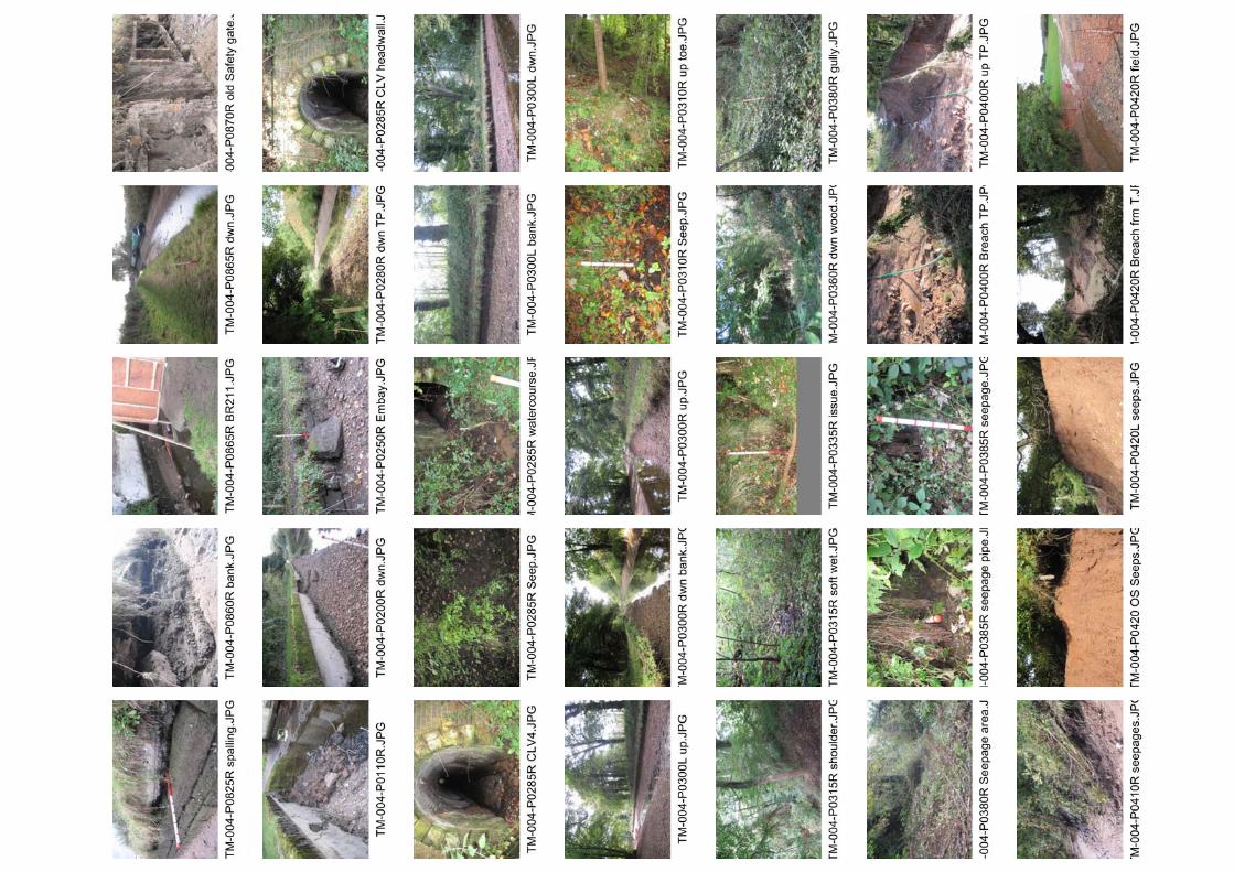
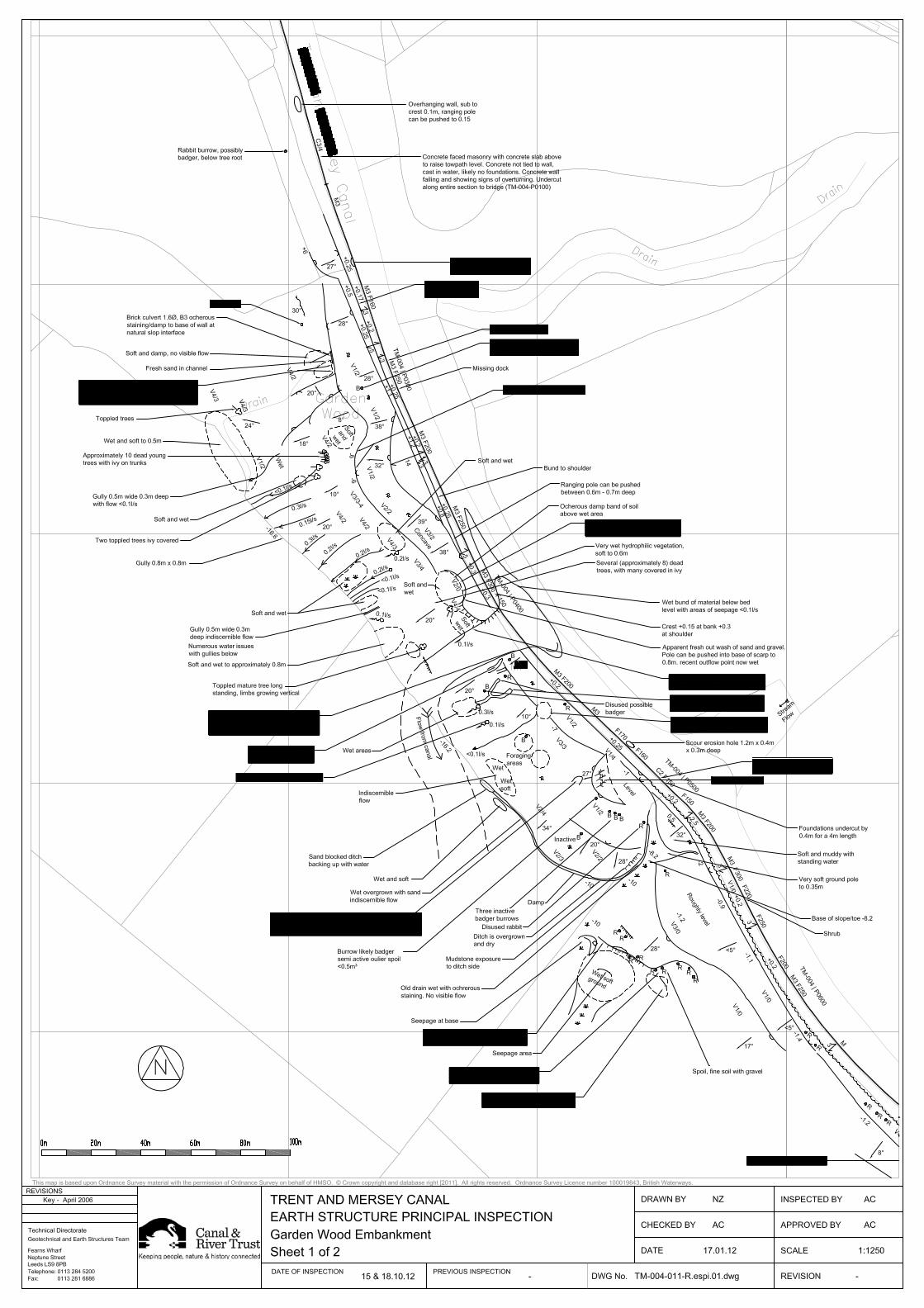
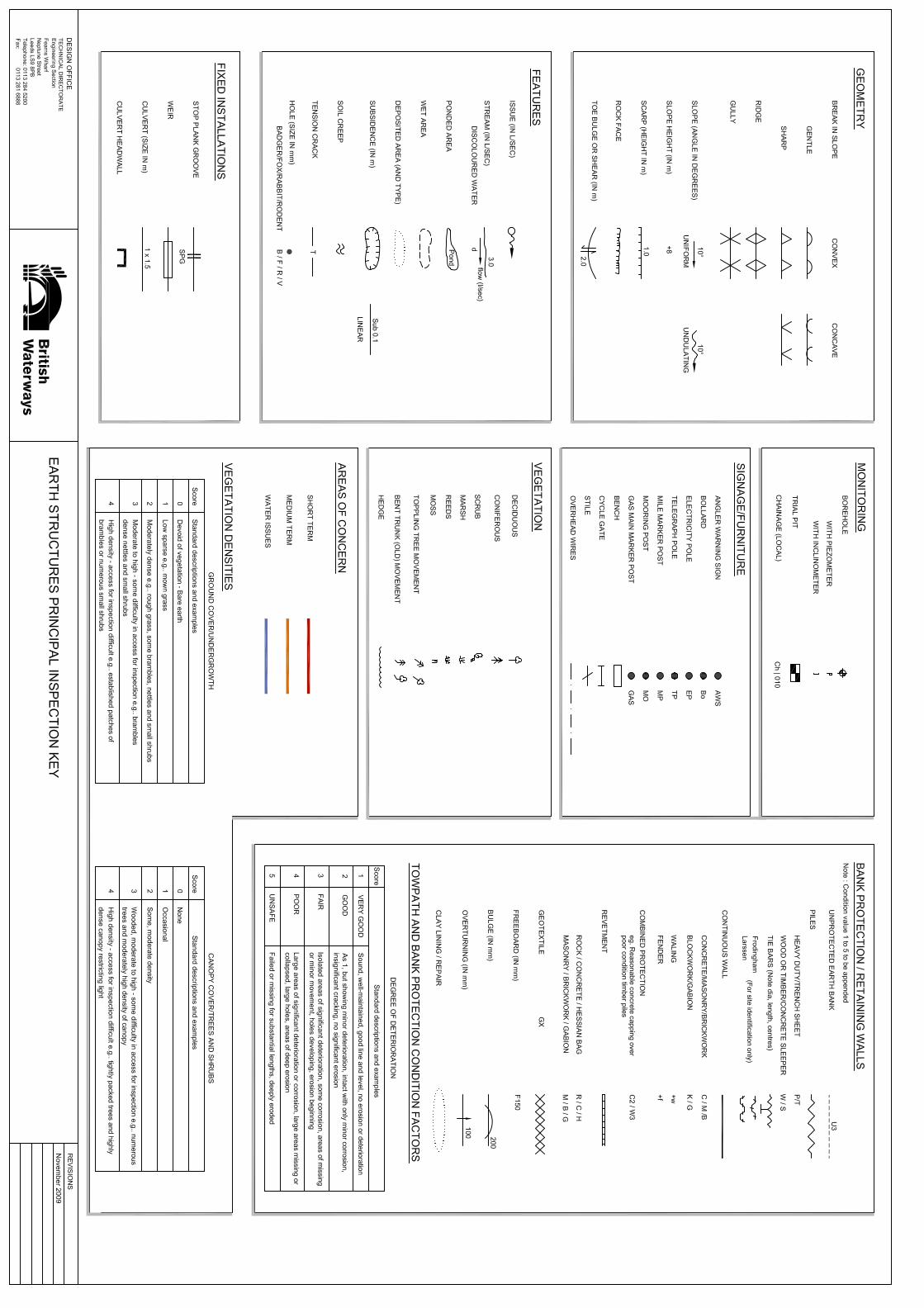
Please refer to the site plans for full details of this inspection. This report should comprise report text, photo summary sheet, annotated plans and associated key. Photographs taken during the inspection are stored against the asset in MOSS.
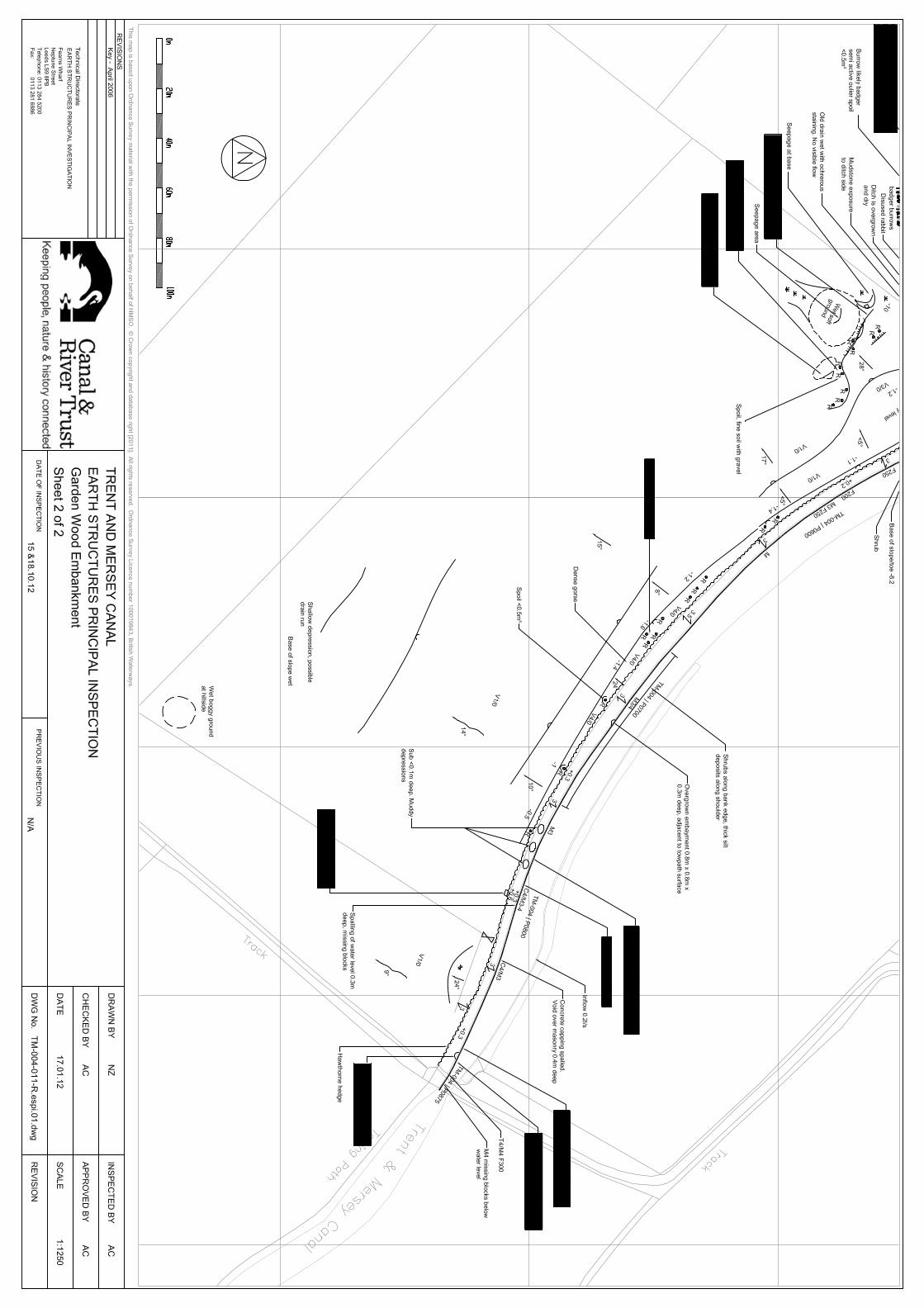
All chainages given in this report have been referenced to canal chainage as displayed on ArcGIS and rounded to the nearest 5 m. Garden Wood Embankment was assumed to run from TM-004-P0250R to TM-004-P0810R and was situated on the towpath side.
It is of note that this embankment (Garden Wood Embankment TM-004-011-R) suffered a slope failure which caused a canal breach on the 25 September 2012. This inspection was undertaken whilst the canal was dewatered as a result of the breach. Therefore leakage pathways on this embankment may not have been apparent.
In writing this report reference was made to the following document:-
Dutton Breach Draft Borehole data (October 2012)
1.0 Geology
1.1 The embankment is situated on Drift deposits shown to be Glaciofluvial Deposits described as Sand and Gravel with Alluvium shown to underlie the fields at the base of the hillside/toe. The underlying solid deposits were shown to comprise of mudstones from the New Red Sandstone Group from the Triassic Period.
1.2 Hyder were requested to undertake a ground investigation of this embankment with site works being undertaken on the 16 to 19 October 2012. Works comprised of a single cable percussive borehole at the toe of the hillside immediately below the breach and three window sample holes along the embankment crest. The window sample holes recorded fine sand with gravel to their terminus at 6 m below towpath. The borehole in the field below recorded sandy clay (assumed to be the alluvium) to a depth of 6.5 m over sand to a depth of 8 m with mudstone encountered to its terminus at 13 m below ground level.
2.0 Defects of Concern
2.1 The following defects of concern were located along the length inspected:
TM-004-P0110R to P0220R – The masonry waterway wall had at some point in the past been faced by concrete. This facing was cast in-situ whilst the canal was in water and wash erosion has subsequently removed bed material/silt from beneath the concrete. As a result the wall is overturning and the concrete facing is collapsing in places. This will require remedial work in the near future if left to deteriorate.
TM-004-P0250R to P0500R – The slope is vegetated with a mature wooded slope along this length with no signs of tree management evident.
TM-004-P0250R – The top courses of the waterway wall had collapsed at this point forming a slight embayment 1 m long. Further deterioration could lead to the development of a leakage pathway in the future.
TM-004-P0280R – The crest had an effective freeboard of 250 mm affecting the asset’s Serviceability. The presence of a shoulder bund between P0300R & P0380R prevented the low towpath heights also affecting the asset’s Serviceability.
TM-004-P0270R – A dead tree was noted on the natural hillside at this point.
TM-004-P0280R to P0290R – Seepage areas were noted both sides of Culvert 4. The northern seepage area had no discernible flow and covered an area of 7 m2.
4 ESPI/1213/9100/TM-004-011-R
The southern area was more extensive with the seepage increasing from soft and wet (where a pole could be pushed to a depth of 0.3 m), to a flow of 0.2 l/s as the seepage intersected the watercourse some 10 m from the toe.
TM-004-P0290R, P0320R, P0330R & P0350R – Missing blocks or areas of open joints were noted to the waterway wall at these points. Repairs should be considered to prevent further deterioration.
TM-004-P0300R – A disused badger burrow was noted mid slope below a holly tree. Spoil was noted to be sandy and 1.5 m3.
TM-004-P0300R to P0340R – A watercourse channel was noted to be overgrown and was becoming clogged by vegetation, silt and leaf litter. This has led to the development of a large area of boggy ground at the intersection of the wooded slope and the adjacent field.
TM-004-P0310R to P0330R – Areas of soft wet ground and seepage were noted at the toe of the embankment approximately 6 m below canal water level. Flows were noted to be indiscernible at the point of issue and drained into the hillside below.
TM-004-P0310R to P0400R – Approximately fourteen shallow gullies and three seepage areas were noted to run down the hillside from an area about the 10 m to 12 m below canal water level. The gullies were typically less than 0.4 m deep and 1 m wide these gullies/seepage areas carried water issues with flows varying from indiscernible to 0.3 l/s. The majority of these issues had flows of between 0.1 l/s to 0.3 l/s. Several are probably related to issues observed to drain into the slope higher up the hillside. Only two were traced from the base of the hillside to the toe of the embankment. The rest were either lost in dense vegetation or were not directly connected at the surface.
TM-004-P0320R to P0330R – Approximately ten dead trees and two toppled trees were noted mid slope approximately 10 m below canal water level. it is likely that these have died due to increased water within the slope.
TM-004-P0320R to P0400R – The toe drain at the base of the hillside was generally overgrown and silted up.
TM-004-P0355R to P0370R – A large seepage area was noted from the toe of the embankment at approximately 6 m below canal water level. it was possible to push a ranging pole to a depth of 0.7 m. Three flows were noted in the vicinity of this area all with flows of 0.2 l/s. two of these flows ran down the slope into the gullies noted above.
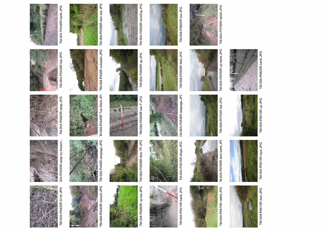
TM-004-P0355R to P0440R – Breach area. The canal bed has been lost within this area and the embankment slope has been removed between P0400R to P0420R where the breach occurred. The underlying rock was exposed in the breach area below the towpath some 5 m below normal canal water level. Four seepages were noted on the offside into the northern half of the breach area from below bed level with flows of up to 0.1 l/s.
TM-004-P0370R to P0400R – The ground below the toe at this point was noted to be soft and wet. It was possible to push a ranging pole to a depth of 0.6 m. This wet area was long standing and vegetation was hydrophilic in nature. A scarp had formed along the toe above this indicative of a regressive slip. The scarp was up to 2.5 m high. At TM-004-P0390R, a fresh area of outwash was noted from the base off the scarp which was considered to be a point of recent outflow. It was not possible to determine if the flow was from canal leakage or groundwater flows under the canal as the adjacent breach had scoured the slope out to rock some 4 m below normal canal water level and flows from either defect type have been interrupted.
TM-004-P0400R to P0450R – The breach material had completely covered the adjacent field and blocked the toe drain, with water overflowing the drain at P0450R.
5 ESPI/1213/9100/TM-004-011-R
TM-004-P0420R to P0460R – Six seepage areas were noted along the toe of the embankment at this point with associated soft ground to depths of between 0.3 m to 0.6 m. Flows were all indiscernible at the point of issue. Four of these flows continued to flow down slope to the base of the hillside and flows into these issues increased to between 0.1 l/s and 0.3 l/s, as between the toe and the base of the hillside further seepage areas were noted to daylight all with indiscernible flows. Only one of these was possibly the re-emergence of seepage from higher up the slope.
TM-004-P0430R & P0480R to P0500R – Disused or inactive badger burrows were noted on the slope with areas of foraging also noted at P0450R. These burrows were not considered to be a risk to the stability of the embankment at this time but will require monitoring by the Length and Ecology teams for any signs of increased activity.
TM-004-P0475R – Three dead trees were noted on the upper third of the slope. No signs of seepage were noted within the vicinity of the tree die back.
TM-004-P0475R to P0490R – Seepage with indiscernible flows were noted into the toe drain at this point.
TM-004-P0450R to P0520R – A drainage ditch has been formed along the base of the wooded slope. This drainage ditch was becoming overgrown but was generally overgrown and damp.
TM-004-P0495R – The concrete waterway wall at this point was noted to be cracked and was becoming undercut by up to 0.4 m over a 4 m length.
TM-004-P0430R to P0700R – The crest was noted to be low along this length with the effective freeboard considered to be between 0.2 m to 0.25 m.
TM-004-P0500R to P0535R – The embankment spans a shallow valley which is considered to have historically carried a watercourse now used as a feeder into an offside winding hole. The embankment increases from 1 m to 8.2 m in height and the lower half of this slope becomes progressively wet with the base of the hillside some 10 m below canal water level being soft wet and boggy.
TM-004-P0530R to P0580R – Rabbit activity and livestock erosion has led to the formation of a large 1 m to 2 m high scarp mid height along the natural hillside. This is not considered to be detrimental to the integrity of the canal.
TM-004-P0535R – An area of wet muddy ground was noted at the base of the hillside.
TM-004-P0650R to P0760R – Rabbit warren along embankment slope face. The embankment was only deemed to be a maximum of 1.6 m high along this length but the burrowing may lead to the development of subsidence on the towpath in the medium to long term.
TM-004-P0720R – An embayment 0.8 m long, 0.8 m wide and 0.3 m deep was noted in the masonry waterway wall adjacent to the towpath surface.
TM-004-P0780R to P0875R – The waterway wall was in a poor condition as concrete capping was badly spalled along this length and numerous blocks were noted to be missing from the waterway wall below the water line. The concrete appears to be historical crest raising works done whilst the canal was in water as the concrete is spalled/undercut to a depth of 0.4 m. At P0875R, overhanging missing masonry extended back 0.7 m under the towpath.
3.0 Geotechnical Assessment / Stability
3.1 Although it is not clear what the definitive cause of the breach on this embankment was it is considered likely that a combination of saturated ground as a result of a period of prolonged heavy rainfall and failure of mature trees may have triggered the slip that led

6 ESPI/1213/9100/TM-004-011-R
to the shortening of the flow pathway and subsequent breach of the canal. Topography and the underlying Geology may have concentrated water flows in the area of the breach but as there are numerous areas of ground water issues from immediately below the toe and on the hillside below, further large soil movements cannot be discounted. As a result of the breach this embankment is Considered to have a Condition Grade E but without further mitigation/investigation, it is unlikely that a Condition Grade above a D would be possible for this structure.
4.0 Sub Asset Summary Table
TM-004-011-R-02
TM-004-P0250R to TM-004-P0300R
Cond D – Groundwater issues at toe
COF 2 - Fields
Serv 2 – Effective freeboard 250 mm
TM-004-011-R-03
TM-004-P0300R to TM-004-P0400R
Cond E – Numerous ground water issues & breach
COF 2
Serv 1 – Effective freeboard 300 mm min
TM-004-011-R-04
TM-004-P0400R to TM-004-P0500R
Cond E – Numerous ground water issues & breach
COF 2
Serv 2 – Effective freeboard 200 mm
TM-004-011-R-05
TM-004-P0500R to TM-004-P0600R
Cond D – Low crest and groundwater issues to slope/toe
COF 2
Serv 2 – Effective Freeboard 200 mm
TM-004-011-R-06
TM-004-P0600R to TM-004-P0700R
Cond C – Rabbit activity to slope
COF 2
Serv 2 – Effective Freeboard 250 mm
TM-004-011-R-06
TM-004-P0700R to TM-004-P0810R
Cond C
COF 2
Serv 1
5.0 Recommendations
Short Term – Within a year
5.1 Slope Stability assessment to Garden Wood embankment outside proposed area of remedial works. Cost Between £1k to £5k. The numerous points of groundwater have led to the saturation of the toe in places with soft wet ground also present on the hillside below. Current plans for remedial works at the time of writing this report were for the lining of the canal between TM-004-P0340R to P0480R. It is considered that other areas of slope beyond this section of failed embankment may also be susceptible to similar failures. It is therefore recommended that the embankment beyond the areas of proposed lining be assessed for stability with elevated water levels to determine the risk and allow the works to be modified as necessary. Areas of specific interest/concern are TM-004-P0280R to P0340R and P0400R to P0430R where ground water issues are from the slope or the embankments toe as well as the hillside below. This assessment may require additional Ground Investigation data to model accurately.
5.2 Embayments TM-004-P0250R & P0720R. Cost Between £1k to £5k. The top courses of the masonry bank protection at these points had failed over short sections (less than 1 m in length), it is recommended that as part of the breach works that these embayments be repaired utilising the fallen masonry in the canal bed.
7 ESPI/1213/9100/TM-004-011-R
5.3 Missing blocks & open joints to Waterway Wall TM-004. Estimated cost £1k to £5k. Missing blocks and areas of large open jointing were noted to the waterway wall between TM-004-P0290R to P0350R. It is recommended that subject to the lining works extent of the breach, that these areas be repaired.
5.4 Undercut and cracked concrete waterway wall, TM-004-P0495R. Estimated Cost £1k to £5k. It is recommended that subject to results of stability assessments that this section of undercut and cracked concrete waterway wall be repaired to prevent further deterioration. Given its proximity to the works area, this should be included in the breach repair works.
5.5 Toe Drain and watercourse channel clearance. Cost between £10k to £20k. The toe drain which runs between TM-0300R to P0530R is becoming clogged with vegetation and silt. As is also the watercourse downstream of the culvert. It is recommended that to aid drainage of the base of the hillside that discussions be held with the relevant land owner to get these ditches cleared.
Medium Term – Within 5 Years
5.6 Crest raising works to TM-004. Cost over £50k. The crest of Garden wood Embankment was noted to be below the ideal freeboard level and it is recommended that this be raised as part of the remedial works to this breached embankment. This work will reduce the risk of overtopping and improve the assets Serviceability Score. Lengths which require raising are:- TM-004-P0280R & P0430R to P0700R.
5.7 Failing and overturning waterway wall TM-004-P0110R to P0220R. Cost Between £20k to £50k. The waterway wall to this section of cutting has been faced/capped with concrete and as a result of deterioration/lack of footings, this has caused the concrete to fail or has resulted in the masonry wall to become unstable and begin to overturn. It is recommended that this section of bank be replaced/rebuilt before failure blocks the reed narrowed channel.
5.8 Undercut/failing waterway wall TM-004-P0780R to P0875R. Cost between £20k to £50k. The waterway wall in this section was noted to have missing blocks in places below the water line with a large area extending 0.7 m into the bank or with loss of material under the capping. It is recommended that the waterway wall be repaired/re-built as necessary and the concrete capping present replaced. This will likely require de-watering to get to the poor bank. Consideration should be given to include this in the breach works if this section of canal is still de-watered.
Long Term – Within 10 years
5.9 None.
Vegetation Issues
5.10 Tree management TM-004 Garden Wood Emb Cost Between £5k to £10k. Dead trees were noted at TM-004-P0270R (1), P0320R to P0330R (10), TM-004-P0475R (3) and mature trees were present along the embankment which are also placing additional loading on the slope. It is recommended that the dead trees be felled and the mature trees on the slope pollarded to reduce loading on the slope which should help reduce the risk of further slope movements.
Monitoring
5.11 Badger activity monitoring. Cost under £1,000. Notification No. 12162027. Given the activity of badgers on this embankment and there distance from the canal, monitoring by the Length Inspection team with annual site visits by the Ecology team is all that is deemed necessary for this structure. Increased activity should be reported and further assessments made as deemed necessary.
Defects of note for Waterway to resolve
5.12 None.
8 ESPI/1213/9100/TM-004-011-R
Costing sections are:-
Cost Under £1,000
Cost Between £1k to £5k
Cost Between £5k to £10k
Cost Between £10k to £20k
Cost Between £20k to £50k
Cost Over £50k


![Tree Structures and Algorithms for Physical Designmath.ucsd.edu/~ronspubs/18_09_tree_structures.pdf · structures (e.g., twin binary trees [41, 42], O-trees [17], and B*-trees [5])](https://img.pdfslide.us/doc/110x75/605adee2ca271c16ff7feaa7/tree-structures-and-algorithms-for-physical-ronspubs1809treestructurespdf.jpg)