Embed Size (px)
Citation preview
I GEOLOGIC INTERPRETATION OF THE GEOTHERMAL POTENTIAL OF THE
NORTH BONNEVILLE AREA
b:i
D. L. Nie lson
M. R. Moran
I
- Prepared for
U S - Department of Energy * _
sion of Geothermal Energy - _
EARTH SCIENCE LABORATORY University of Utah Research Institute
Salt Lake City,, Utah
DISCLAIMER
This report was prepared as an account of work sponsored by an agency of the United States Government. Neither the United States Government nor any agency Thereof, nor any of their employees, makes any warranty, express or implied, or assumes any legal liability or responsibility for the accuracy, completeness, or usefulness of any information, apparatus, product, or process disclosed, or represents that its use would not infringe privately owned rights. Reference herein to any specific commercial product, process, or service by trade name, trademark, manufacturer, or otherwise does not necessarily constitute or imply its endorsement, recommendation, or favoring by the United States Government or any agency thereof. The views and opinions of authors expressed herein do not necessarily state or reflect those of the United States Government or any agency thereof.

DISCLAIMER Portions of this document may be illegible in electronic image products. Images are produced from the best available original document.
UNIVERSITY OF UTAH RESEARCH INSTITUTE
UURI 1 EARTH SCIENCE LABORATORY 420 CHIPETA WAY, SUITE 120 SALT LAKE CITY, UTAH 84108
TELEPHONE 801 -581 -5283
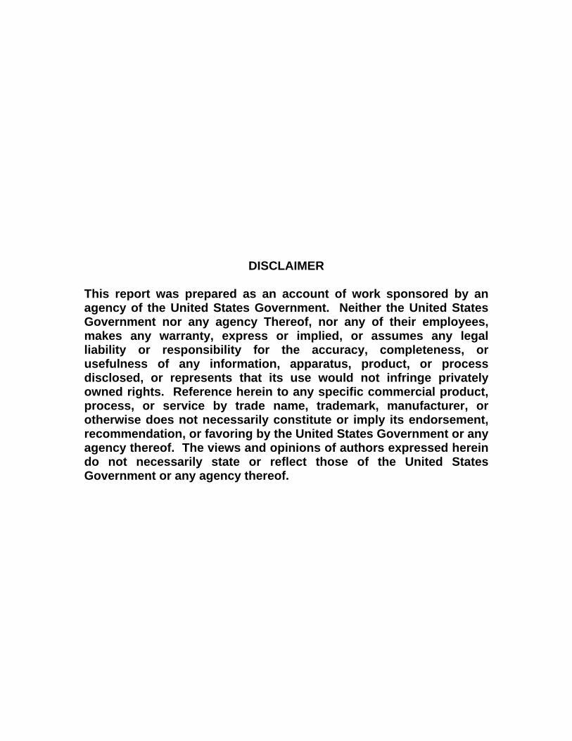
February 15, 1980
Mr. Pollard Dickson P1 a n n i ng Director City of North Bonnevi 11 e North Bonneville, WA 98639
J Dear Mr. Dickson:
J T h i s l e t t e r will serve as a f i n a l report for the geothermal evaluation of
the North Bonneville area which was funded by the Department of Energy's User
J Assistance Program. Included i s the report and geologic map completed by our
I consu l t an t Michael R. Moran. He has done a very good j o b o f defining the
geology of the area.
I
J As p a r t of t h i s study we have used Mike Moran's report and recommenda- 1 able water analyses and temperature gradients from t h ! t ions in l i g h t of avai
North Bonnevi l le area.
model of the geotherma
From t h i s in format ion w e have deve loped a conceptual
system, and will propose an exploration program based
on t h i s model. We view t h i s proposed program as the most eff ic ient procedure
fo r evaluating,-the geothermal potential of the N. Bonneville area. I t i s
common t o use electr ical geophysical surveys for t h i s type of exploration;
however, we have not recommended these surveys because the hydroelectric plant
and powerlines in the North Bonneville area will negate the i r usefulness. I Examination of Moffetts Hot S p r i n g permits the evaluation of the geologic
controls on the geothermal system.
east-trending l inear feature. Poor exposures-prevent actual examination of
Moffetts i s located along a s t rong north-
J
1
a
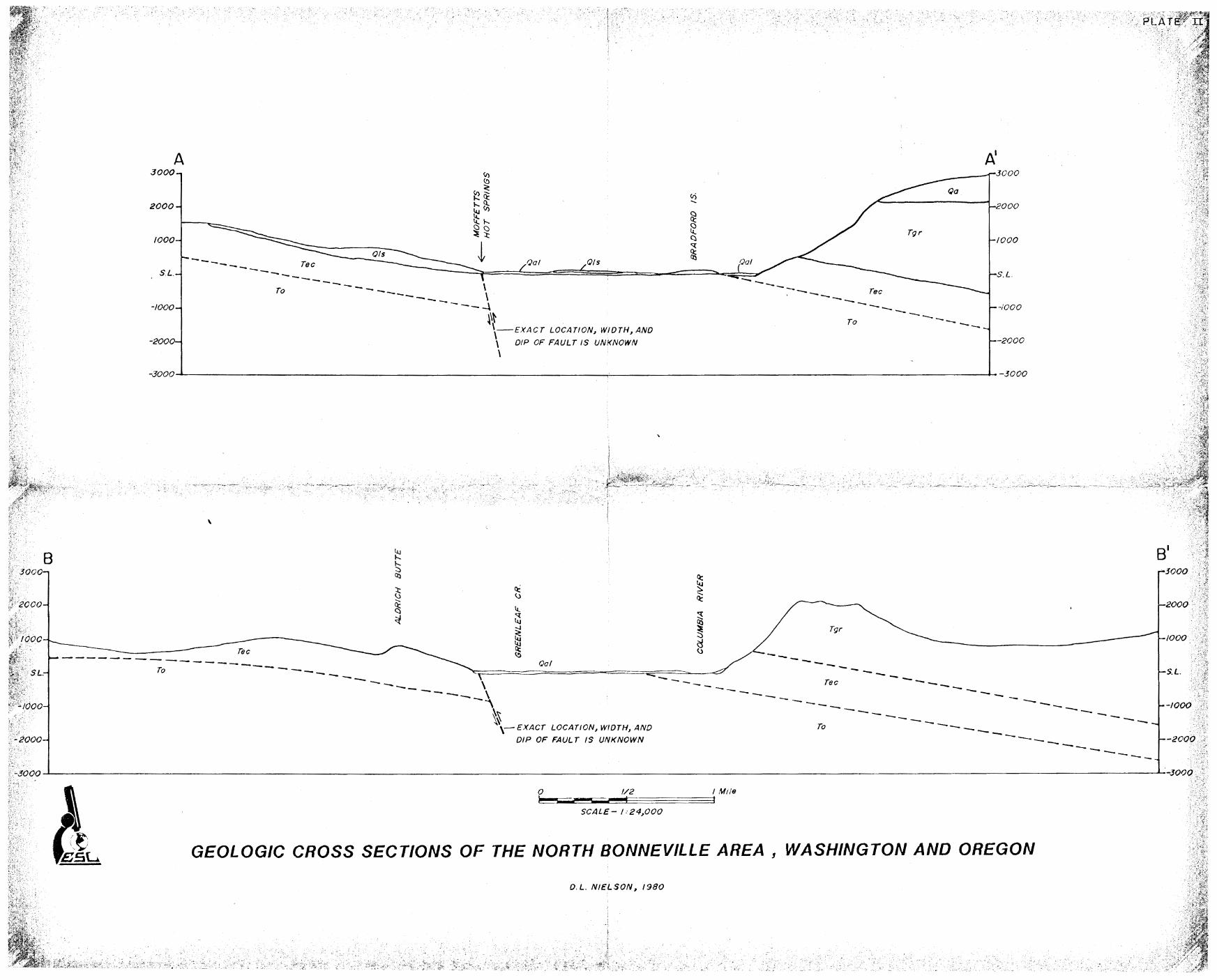
this feature, b u t geologic cross sections (Plate 11) w h i c h I have drawn on the
basis of Moran's mapping (Plate I ) require displacements of u p t o 2000 feet
along a reverse f a u l t o r zone of faul ts which I interpret as ly ing a l o n g the
nor th side of the Columbia River Gorge. Several northwest-trending l inear
features intersect the northeast l inear a t Moffetts and i t i s t h o u g h t t h a t
t h i s intersection increases permeability a long the structural zones so t h a t
thermal waters are able t o migrate t o the surface.
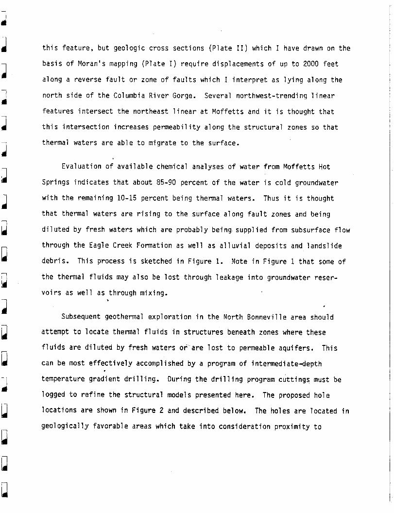
Evalua t ion of available chemical analyses of water from Moffetts Hot
Springs indicates t h a t a b o u t 85-90 percent o f the water i s cold groundwater
w i t h the remaining 10-15 percent being thermal waters.
t h a t thermal waters are r is ing t o the surface along f a u l t zones and being
Thus i t i s t h o u g h t
diluted by fresh waters which are probably being supplied from subsurface flow
t h r o u g h the Eagle Creek Formation as well as alluvial deposits and landslide
debris.
the thermal f luids may also be lost t h r o u g h leakage i n t o groundwater reser-
This process i s sketched i n Figure 1. Note i n Figure 1 t h a t some o f
voirs as well as through mixing. 1
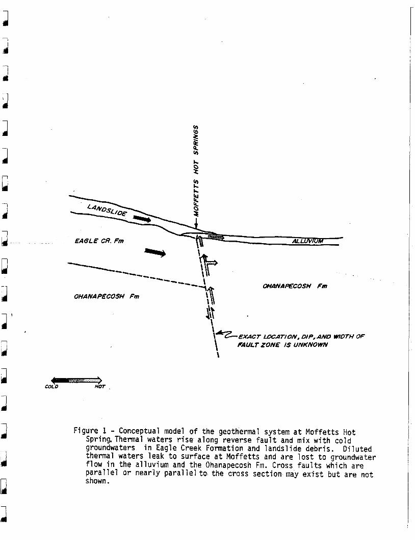
Subsequent geothermal exploration i n the North Bonneville area should
a t tempt t o locate thermal f lu ids i n structures beneath zones where these
f luids are diluted by fresh waters or'are lo s t t o permeable aquifers. This
can be most effectively accomplished by a program of intermediate-depth
temperature gradient dr i l l ing.
logged t o refine the structural models presented here.
locations are shown i n Figure 2 and described below. The holes are located in
geologically favorable areas which take into consideration proximity t o
During the d r i l l i ng program cuttings must be
The proposed hole
I
1 1
1 a
1‘ ,
h
B 2 k
EAGLE CR. Fin ALLUVIUM *
_ _
\ WHNAAFCOSH Fm
---- -- ---- OHANAPECOSH Fm
cui0 nor
\ \1’z-EXACT m A T / O N , DIP,AND WDTH OF \ FAULT ZONE IS UNKNOWN \
Figure 1 - Conceptual model of the geothermal system a t Moffetts Hot Spring.Therma1 waters r i s e along reverse f a u l t and mix w i t h cold groundwaters i n Eagle Creek Formation and landslide debris. Diluted thermal waters leak t o surface a t Moffetts and are lost t o groundwater flow i n the a l l u v i u m and the Ohanapecosh Fm. Cross fau l t s which are parallel or nearly parallel to- the cross section nay ex is t but are not shown .
J a
1
a I
1 1
proposed use. One of the principal purposes i s t o t e s t the favorabili ty o f
the main northeast-trending f a u l t and determine i t s location and d i p .
S i te 1: The purpose of t h i s hole i s t o t e s t the f a v o r a b i l i t y of the
northeast-trending reverse f au l t or zone of f a u l t s .
waters found in t h i s area could be used i n the western portion of
the c i t y as well as the central business d i s t r i c t . Proposed d e p t h :
500 feet .
Geothermal
S i te 2: Same purpose as hole #l. Proposed depth: 500 feet .
S i te 3: The purpose of t h i s hole i s t o t e s t the favorabili ty of the warm
water source which was reported t o exis t p r i o r t o bridge
reconstruction. This area i s very close t o the central business
d i s t r i c t which i s the principal area of proposed use. Proposed
depth: 500 feet .
S i te 4: The purpose of t h i s s i t e i s t o t e s t the geothermal potential along a
zone of intersection of the northeast-trendi ng reverse f au l t ( s ) and
the Tanner Creek linear. As discussed previously, this intersection
may be important in developing permeability along the fau l t zones
which i s required t o t r anspor t appreciable quantit ies of thermal
fluids.
desired.
f l o w of water a t the resort.
This hole may be located closer t o Moffetts Hot Springs i f
If this i s done the exploration d r i l l i ng may disrupt the
Proposed depth: 500 feet .
During t h i s d r i l l i ng program i t i s important t h a t cuttings be collected
a t a minimum of ten-foot intervals. Careful l o g g i n g of these cuttings will be
1 J
..... ... . . ~ . .... . ....... ............ .................. ... ......
l a a I 1 1 1 I 1
J
i mport a n
system.
i n u p d a t i n g the conceptual exploration model of the geothermal
I n a d d i t i o n t o temperature logs, i t would be advantageous t o acquire
SP, r e s i s t i v i ty , and gamma logs of the holes.
stratigraphy and structure as well as evaluating zones o f fresh water and
thermal water entr ies i n t o the d r i l l hole. In a d d i t i o n , f l u i d should be
collected from the holes are regular intervals.
These are important in defining
Data acquired d u r i n g this t e s t program should be synthesized and
evaluated prior t o the decision t o s i t e and d r i l l a production hole.
Please do not hesitate t o contact me i f you have any questions about t h i s
program or the geothermal resource a t North Bonneville.
2
DLN: srm
cc: R. Bendixson, DOE M. Korosec, WA-DHR D. Struhsacker, ESL
Best regards,
Dennis L. Nielson Geol ogi st/Project Manager
P
1 I
II
1 a 3 I J
3 I 1
l
a 1
I
ul
GEOLOGIC INTERPRETATION OF THE GEOTHERMAL
POTENTIAL OF THE NORTH BONNEVILLE AREA
REPORT TO:
Dennis L. Nielson University o f Utah Research Ins t i tu te Earth Science Laboratory 420 Chipeta Way, Suite 120 Sal t Lake City, U t a h 84108
COMPILED BY:
Michael R. Moran 4121 N. E. 29th Avenue Port1 and , Oregon 97211 (503) 287-7931
a
Q R
B B
u
n
CONCLUSIONS:
Possi b l e geothermal devel opment for the townshi p of North Bonnevil 1 e ,
Washington i s being investigated because of the proximity o f the town t o hot
springs i n a geologic province of good geothermal potential. Surface
expression of geothermal resources i s provided by conduits t h r o u g h an
impermeable reservoir cap and i s therefore generally s t ructural ly control led.
Near North Bonnevil l e the geologic formations t h a t under1 i e potential
d r i l l i ng s i t e s are the Eagle Creek Formation and the Ohanpecosh Formation.
The Lower Miocene Eagle Creek Formation i s composed of poorly consolidated
volcanic conglomerates, sandstones, tuffs , and includes a few minor
i nterbedded 1 ava f l ows.
in i t s nearest exposures t o North Bonneville i s composed of volcaniclastics
The Eocene-01 i g i ocene Ohanapecos h (Wei gl e ) Format i on
and lava flows. The Ohanapecosh has been altered t o zeol i tes and clays and i s
therefore well consolidated and impermeable. The lack of permeability
provides the necessary reservoir cap for any geothermal system tha t may be
,present a t depth.
drainage i s greater t h a n 19,000 f t . th ick (Wise, 1970).
This formation, t o the northeast, i n the Wind River
Circulation of
geothermally heated water from this th ick sequence of impermeable strata must
be associated w i t h penetrating fracture tones. s
Identifiable fractures and f au l t s are lacking in the vicini ty of in te res t
primarily because large areas are covered e i the r by landslides or alluvium.
However, projection o f l ineations into the region and the alignment of
geologic features provides some insight into the problem.
3
I I
d
I
a
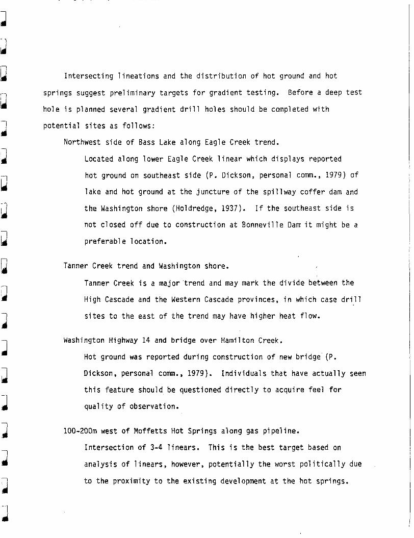
Intersecting l ineations and the distribution of hot ground and ho t
springs suggest preliminary targets f o r gradient testing.
hole i s planned several gradient d r i l l holes should be completed w i t h
potential s i tes as follows:
Before a deep t e s t
Northwest side of Bass Lake a long Eagle Creek trend.
Located a1 ong 1 ower Eagle Creek 1 i near which d i spl ays reported
hot ground on southeast side (P. Dickson, personal comm., 1979) of
lake and hot ground a t the juncture of the spillway coffer dam and
the Washington shore (Holdredge, 1937).
n o t closed off due t o construction a t Bonneville Darn i t might be a
preferabl e 1 ocation.
I f the southeast side i s
Tanner Creek trend and Washington shore.
Tanner Creek i s a major trend and may mark the divide between the
High Cascade and the Western Cascade provinces, i n w h i c h case d r i l l
s i t e s t o the east of the trend may have higher heat f l o w .
Washington Highway 14 and bridge over Hamilton Creek.
Hot ground was reported d u r i n g construction of new bridge (P.
Dickson, personal corn., 1979). Individuals t h a t have actual ly seen
t h i s feature should be questioned d i rec t ly t o acquire feel for
q u a l i t y of observation.
100-200m west o f Moffetts Hot Spr ings along gas pipeline.
Intersection of 3-4 l inears.
analysis of l inears , however, potentially the worst po l i t i ca l ly due
t o the proximity t o the existing development a t the h o t springs.
This i s the best target based on
3
INTRODUCTION:
The central pa r t o f the Columbia River Gorge near the new town of North
Bonneville i s i n the Cascade Range geologic province.
stratigraphy i s exposed and i s ent i re ly volcanic i n o r i g i n except f o r alluvium
and landslide deposits.
dikes are located nearby as well as a small Quaternary volcanic center and
associated deposits.
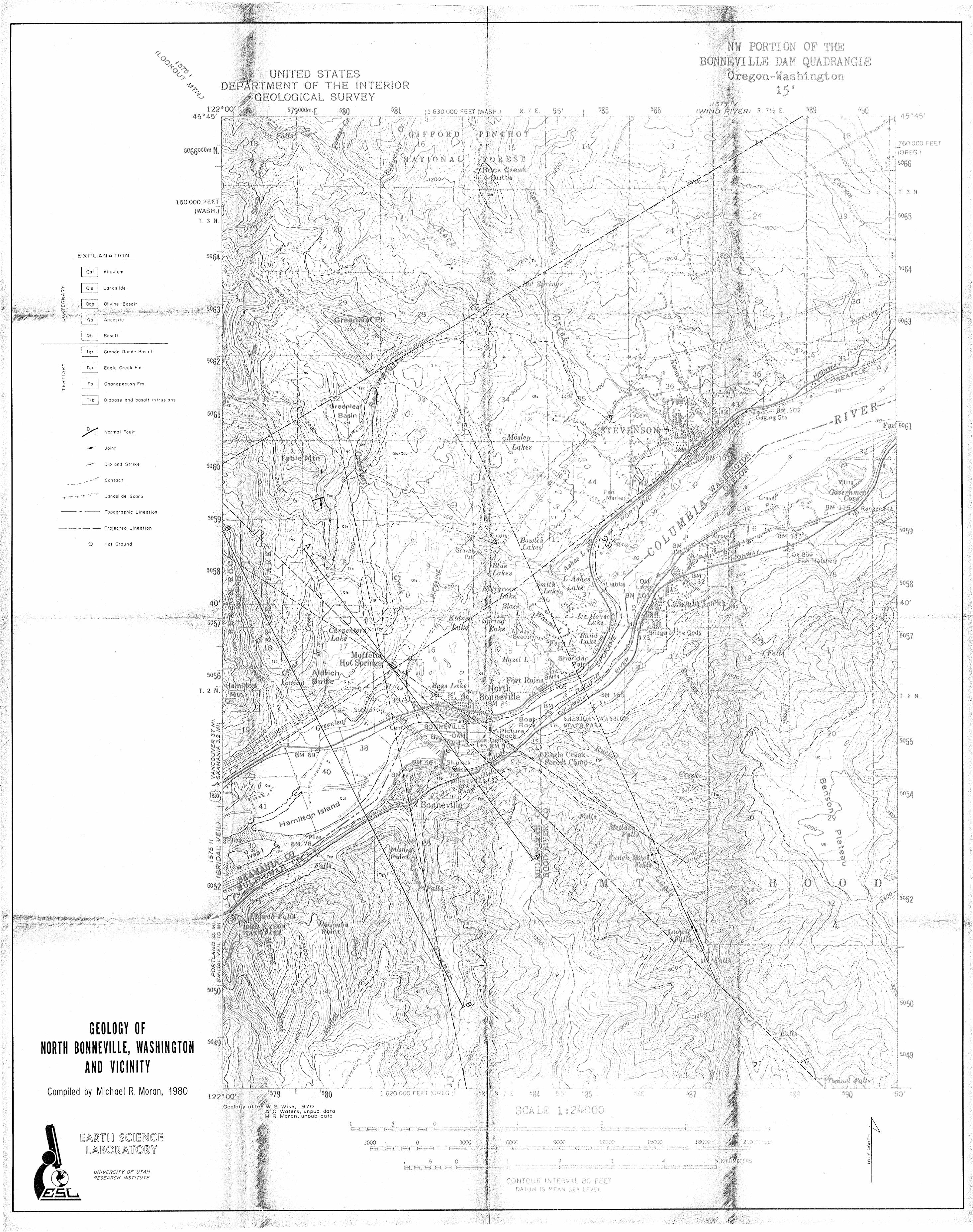
i s presented here as Plate I .
Only Cenozoic
Small intrusives in the form#of volcanic necks and
A geologic map was completed as a p a r t of the study and
Structure i n the area i s represented by gentle folds and limited
definable faulting.
and are presumed t o represent major tectonic jo in ts or f au l t s w i t h minimal
di spl acement.
Minor topographic l ineations, however, are f a i r l y common
Moffetts Hot S p r i n g s and S t . Martins Hot S p r i n g s t o the east near the
The hot t o w n of Carson have temperatures of 320 C and 490 C respectively.
springs are s t ructural ly controlled and are probably located a t the
intersection of more t h a n one fracture trend.
underlies the area and i s considered t o be an aquiclude due t o
postdepositional formation o f zeol i tes and clays.
The Ohanapecosh Formation
Potential geothermal
i s viewed as being dependent upon fracture zones fo r devel opment , therefore,
water c i rcul a t i on.
Z. F. Danes i s ana
and i t i s f e l t t h a t the
yzing and modeling a recent gravity survey in the area
result ing d a t a may subs tan t ia te the presence of
subsurface fracture zones.
d r i l l i ng s i t e until the gravity d a t a i s made available potential good s i t e s
Although i t i s somewhat premature t o suggest a
I 1
I 11
9 1
1
a
I J I 1 13
are 100-200m west of t h e development a t M o f f e t t s Hot Spr ings a long the gas
p i p e l i n e and an e q u a l l y access ib le b u t s t r u c t u r a l l y l e s s d e s i r a b l e l o c a t i o n i s
a t t h e i n t e r s e c t i o n o f t h e power l ine and road about 400m southeast o f M o f f e t t s
Hot Springs.
STRATIGRAPHY :
The bedrock s t r a t i g r a p h y o f t h e Cascade Range i n t h e Columbia R ive r Gorge
near t h e town o f Nor th Bonnev i l l e i s composed o f about 25,000 ft. o f Cenozoic
vo l can ic rocks.
e n t i r e s e c t i o n and i n c l u d e t h e Ohanapecosh Formation, t h e Eagle Creek For-
mation, and t h e Grande Ronde Basa l t w i t h i n t h e Yakima Basa l t Subgroup o f t h e
Columbia R i v e r Basa l t Group. The remainder o f t h e area i s u n d e r l a i n by small
Quaternary Basa l t occurrences and a few smal l i n t r u s i o n s . Much o f t h e bedrock
i n t h e area i s obscured by l a r g e l a n d s l i d e s and recent a l luv ium.
Three major s t r a t i g r a p h i c fo rmat ions account f o r n e a r l y t h e
Ohanapecosh Formation:
The o ldes t known fo rmat ion i n t h e v i c i n i t y o f Nor th Bonnev i l l e i s t h e
Eocene-Oligocene Ohanapecosh Format ion ( P l a t e I ) . Many o l d e r r e p o r t s r e f e r t o
t h i s u n i t as t h e Weigle Formation.
fo rmat ion is grea te r than 19,000 ft. t h i c k (Wise, 1970) and i s composed
predominate ly of conso l i d a t e d vo l cani c l a s t i cs and 1 esser amounts o f 1 ava
flows.
possesses p r o p o r t i ona te l y more 1 ava f l ows and 1 i ke t h e format i on e l sewhere i s
w e l l conso l i da ted due t o pos tdepos i t i ona l a l t e r a t i o n which has l e d t o t h e
fo rmat ion o f z e o l i t e s and c lays. Sur face exposures i n d i c a t e t h a t t h i s u n i t
I n t h e nearby Wind R i v e r dra inage t h i s
The upper p o r t i o n o f t h e s e c t i o n exposed neares t t o Nor th Bonnev i l l e
should behave as an aquic lude and thereby p rov ide some confinement o f any
geothermal resource present a t depth.
Eagl e Creek Format ion ;
Over ly ing t h e Ohanapecosh Format ion i s t h e Lower Miocene Eagle Creek
Format ion ( P l a t e I ) .
v o l c a n i c l a s t i c s i n t h e form o f conglomerates, sandstones, and t u f f s , and
occas iona l l y an in terbedded l a v a f low. U n l i k e t h e Ohanapecosh t h e Eagle Creek
i s p o o r l y conso l ida ted and because o f t h e na ture o f t h e abundant conglomerates
may prove some problems f o r d r i l l i n g .
Bonnev i l le , i s t h e sur face bedrock format ion and because o f i t s permeable
cha rac te r would tend t o d i s s i p a t e c i r c u l a t i n g f l u i d s . D r i l l ho le in format ion
from t h e USCE i n d i c a t e t h a t t h e base o f t h e Eagle Creek Format ion near
M o f f e t t s Hot Spr ings i s probably l e s s than 500 ft. f rom t h e surface.
Th is fo rmat ion i s composed almost e n t i r e l y o f
The Eagle Creek, i n t h e area of Nor th
Grande Ronde Basa l t ;
Unconformably o v e r l y i n g t h e Eagle Creek Format ion i s a Middle Miocene
sequence o f t h o l e i i t i c f l o o d b a s a l t s g r e a t e r than 1500 ft. t h i c k .
b a s a l t s a r e t h e c l i f f formers o f most o f t h e Columbia R i v e r Gorge b u t they a r e
t o p o g r a p h i c a l l y above any p o t e n t i a l d r i l l i n g s i t e f o r t h i s p r o j e c t and
These
t h e r e f o r e are s i g n i f i c
reg iona l s t ruc tu re .
INTRUSIONS AND YOUNGER
I n t r u d i n g t h e Eag
, n t o n l y i n p r o v i d i n g i n f o r m a t i o n concerning some o f t h e
BASALTS :
e Creek Format ion on t h e south f l a n k o f Table Mountain
a re a smal l d iabas ic neck and associated dike.
dated o n l y as younger than Eagle Creek i n age.
Th is rock has been r e l a t i v e l y
However, i t s o r i e n t a t i o n and
d
7 1
J
I
3
J3
il
I
association w i t h tectonic jo in t s indicate t h a t i t may be younger t h a n Grande
Ronde Basalt. A regional fracture zone projected i n t o the area from Tanner
Creek-Blazed Alder Creek south of the Columbia River may be the controlling
s t ructure , in which case i t may be Pliocene o r younger.
Another diabasic body i s exposed a t the south abutment of Bonneville Dam
Powerhouse. This rock i s known only t o be younger t h a n Eagle Creek and covers
a surface area of l e s s than 1/4 mi2.
intrusive i n USCE reports, however i t possesses some f low character is t ics near
i t s t o p and also displays locally abundan t vesiculation and i s therefore
considered t o be emplaced a t or very near t o the then existing surface.
T h i s u n i t has been described as
Red Bluffs Basalts;
Probably the most important of the younger volcanic features i n the area
fo r the development of geothermal resources i s the Red Bluffs olivine basalt
volcanic complex.
been displaced by the Bonneville Landslide, i t possesses a re la t ively intact
Covering an area of only about 2 m i 2 , most o f which has . >
cinder cone which i s indicative o f an age probably no older t h a n Pleistocene.
The south trending face of Red Bluffs i s a complex of basalt intermixed w i t h
cinder and i s probably the approximate location of the vent. A t the t o p of
the landslide scarp i s approximately 1/4 m i 2 of in situ basalt t h a t probably /-
represents nearly a l l of the basalt t h a t was deposited in Greenleaf Basin.
This volcanic f i e ld should be further studied by geophysical methods i n an
attempt t o identify the presence o f controlling structures. I t should be
accurately d a t e d , especially i f an associated structure can be located.
1 J 3 I
3 3
3 3 1
I 3 1
Sheridan P o i n t Lava F l o w ;
A 30 f t . thick flow i s exposed fo r about 1 /4 m i . i n road cuts a t Sheridan
P o i n t tha t i s of unknown extent and source.
Basalt ta lus and i s overlain by landslide deposits.
flow indicates t h a t i t probably was f a i r l y limited i n volume and extent upon
emplacement and because i t i s f e l t t h a t such a limited flow could not defeat
and cross the Columbia River the most l ike ly source for this basalt i s south
The flow re s t s on Columbia River
The known extent of th i s
of Wauna Lake which marks the approximate south shore of the pre-slide
Columbia River.
Oregon side of the Col umbia.
The source may be i n the present r iver channel or on the
Many other small volcanic centers are present on b o t h sides o f the
Columbia River b u t a re consi,dered t o be t o o dis tant from North Bonneville t o
have a direct bearing on potential geothermal resources fo r t h i s community.
Moreover, much of the area immediately surrounding North Bonneville i s covered
by the 700 year old Bonneville Landslide (Lawrence and Lawrence, 1958) and
modern Columbia River alluvium thus requiring some speculation regarding the
location o f potential d r i l l si tes.
STRUCTURE:
Bedrock exposures i n the region are somewhat limited by l a n d s l i d e s ,
a1 1 u v i urn, coll u v i u m , t a l us, and thick vegetation. T h i s amount o f cover
coupled w i t h formations tha t are d i f f i c u l t t o correlate s t ra t igraphical ly any
distance has limited the number o f ident i f iable structures, especially fau l t s
and tectonic joints . I n general the area i s represented by gentle folds w i t h
low structural r e l i e f and a regional southward dip averaging 10' north o f the
I
3
I
1 3 1 J
3 I I J I I
Columb a River and 50 south of the r iver . Due t o the general impermeab
of the underlying Ohanapecosh Formation tectonic f ractures , j o i n t s , and
are deemed one of the more important geologic aspects for successful
devel opment of nearby geothermal resources. .
F a u l t s ;
l i t y
f au l t s
The only definable fau l t mapped i n the study area i s located on the south
flank o f Table Mountain and displaces Grande Ronde Basalt about 50 f t . down t o
the north on a vertical fau l t plane (Plate I ) .
i s representative of structural trends mapped t o the east i n the Kl i cka ta t
The trend of the f au l t , N70E,
River (J . L. Anderson, personal comm., 1979) and from the Wind River t o the
Klickatat River ( P . E. Hammond, personal comm., 1980).
t h a t possess t h i s trend tend t o be i n echelon systems t h a t form regional zones
Faults t o the east
trending N60E. Potential regional structural trends t h a t define the N60E
trend are the Red Bluffs-Grays Hot Springs lineation and the Moffetts Hot
Spr ings-St . Martins Hot Springs trend.
from the alignment of the saddle i n Table Moun ta in , the 800 f t . scarp i n the
Eagle Creek Formation exposed in Red Bluffs, the position of Grays Hot
Springs, and a small saddle above Carson Creek t o the east . A parallel trend
can be observed by constructing a l i ne from Moffetts Hot Springs t h r o u g h S t .
Martins Hot Spr ings . This l ine defines the nor th shore of the pre-Bonneville
Landslide Columbia River and follows the r iver t o the southwest for more t h a n
20 miles. SLAR imagery indicates the same trend i n the Gorge walls on the
Oregon side of the river. T h i s persi t a n t trend has displacements o f over I
300m t o the east and may have a significant impact on the bedrock geology in
A strong 1 inear correlation exis ts
I
I E E
3
3
II 13
63
t h i s region, such as the unanticipated structural h i g h i n the Ohanapecosh
Fo'rmation beneath the Bonnevil l e Lands1 ide.
Eagle Creek i s the largest stream flowing north i n t o the Columbia River
The lower 6 between the Sandy-River t o the west and Hood River t o the east .
m i . of the creek i s divided into 3 equal s t r a igh t l i ne segments t h a t a re
believed t o be s t ructural ly controlled (Plate I ) .
mouth and the segment furthest from the mouth intersect near Moffetts Hot
S p r i n g s along trends of N55W and N45W, respectively.
The segment nearest the
Tectonic breaks were
of these trends. The middle trend possesses a p a i r of
cal fractures w i t h associated narrow breccia zones
found along ne
we1 1 devel oped
trending N25W.
ther
vert
The dominant northwest trend i n the immediate area i s the Tanner
Creek-Blazed Alder Creek trend.
Columbia River drainage side of t h i s trend, however, i n the B u l l Run River
drainage along Blazed Alder Creek t h i s trend i s observed t o have narrow
breccia zones and controls the emplacement o f a t least two small dikes. T h i s
trend i s considered t o be an area of extension along a diverging wrench zone
and i f i t continues t o Moffetts Hot Springs i t could provide substantia water
circulation through fractures.
HOT SPRINGS:
Observed tectonic features are lacking i n the
Moffetts Hot Spr ings i s located about 2 m i . northeast of North Bonneville
and has a surface temperature of 32O C w i t h a predicted reservoir temperature
of l ess t h a n 80' C (Schuster, and others, 1978).
northeast of North Bonneville i s S t . Martins Hot S p r i n g s w i t h a surface
Located about 11 miles
temperature of 490 C and a predicted reservoir temperature of less t h a n 800 C
(Schuster, and others , 1978).
Hot ground was encountered d u r i n g the construction of Bonneville Dam and
i s recorded t o be 600 F when the ambient temperature was 20° F. Three areas of
hot ground were observed, one near the upstream end of the n a v i g a t i o n locks,
the northeast abutment o f the powerhouse on Bradford Island, and a t the
Washington shore and the downstream end of the n o r t h spi l lway coffer-dam
(Holdredge, 1937).
Eagle Creek trend.
The northern most of the hot spots 1 i e s on the N55W 1 inear
The State of Oregon Department of Geology and Mineral Industries dr i l led
a 500 f t . geothermal gradient hole about 2 miles southwest o f North Bonneville
a t ' the m o u t h of McCord Creek on the south shore of the Columbia.
temperature was about l oo C and the calculated gradient about 50° C/Km i s
consistant w i t h t h a t of the region (J . Riccio, personal comm., 1980).
Bottom hole
d
3 a
I a
REFERENCES CITED
Holdredge, C. P . , 1937, Fumaroles a t Bonnevi l le : Geological SOC. o f the Oregon Country News Letter, v . 3 , n . 9 , p . 96-97.
Lawrence, D. B., and E . G . Lawrence, 1958, Bridge o f the Gods Legend, i t s o r i g i n , h i s t o r y , and d a t i n g : Mazama, v . 40, no. 13 , p. 33-41.
S c h u s t e r , J . Eric, D. 0. Blackwell , P. E. Hamond, and M. T. Hunt t ing , 1978 Heat f low s t u d i e s i n the Steamboat Mountain-Lemi Rock a r e a , Skamania County, Washington: Info. Cir. 62, 56p.
Washington Div is ion o f Geology and Earth Resources
Wise, W. S., 1970, Cenozoic volcanism i n the Cascade Mountains o f Southern Washington: Washington Div is ion o f Mines and Geology Bul l . 60, 45p.
t v
f i Norma l Fault
-v Joint
< Dip and S t r i k e
/ / / Contac t
+------
... /.,
...,, 3
,., ,.4 ;..:t,,,j . . ;,,';..:;..:' $ < ...~. : .... '
'>
Topographic L inea t ion ---
----- Pro jec ted L i n e a t i on
0 Hot Ground
--
NORTH A N D VICINITY
Compiled by Michael R. Moran,
a
1000.
s L..
-1000
-2000:
-3000
DIP OF FAULT IS UNKNOWN ---,
0 f/2 I Mlie 4
SCALE - I : 24,000
GEOLOGIC CROSS SECTIONS OF THE NORTH BONNEVILLE AREA WASHINGTON AND OREGON
O . L . NIELSON, 1980