Embed Size (px)
Citation preview
Earth Science Data and Information System (ESDIS) Project Update
Drew Kittel
NASA ESDIS Project Status
NSIDC UWG Meeting
September 3, 2014
0
100
200
300
400
500
600
700
800
900
FY00 FY01 FY02 FY03 FY04 FY05 FY06 FY07 FY08 FY09 FY10 FY11 FY12 FY13
EOSDIS Product Distribution Trend Millions
0.00
2.00
4.00
6.00
8.00
10.00
12.00
FY00 FY01 FY02 FY03 FY04 FY05 FY06 FY07 FY08 FY09 FY10 FY11 FY12 FY13
Vo
lum
e (
PB
s)
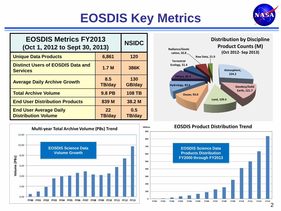
Multi-year Total Archive Volume (PBs) Trend
EOSDIS Key Metrics
2
EOSDIS Science Data
Products Distribution
FY2000 through FY2013
EOSDIS Science Data
Volume Growth
EOSDIS Metrics FY2013 (Oct 1, 2012 to Sept 30, 2013)
NSIDC
Unique Data Products 6,861 120
Distinct Users of EOSDIS Data and
Services 1.7 M 386K
Average Daily Archive Growth 8.5
TB/day
130
GB/day
Total Archive Volume 9.8 PB 108 TB
End User Distribution Products 839 M 38.2 M
End User Average Daily
Distribution Volume
22
TB/day
0.5
TB/day
Atmosphere, 224.2
Geodesy/Solid Earth, 121.7
Land, 109.4
Ocean, 93.0
Hydrology, 83.6
Others, 83.4
Terrestrial Ecology, 51.4
Radiance/Geolocation, 50.8
Raw Data, 21.9
Distribution by Discipline Product Counts (M)
(Oct 2012- Sep 2013)
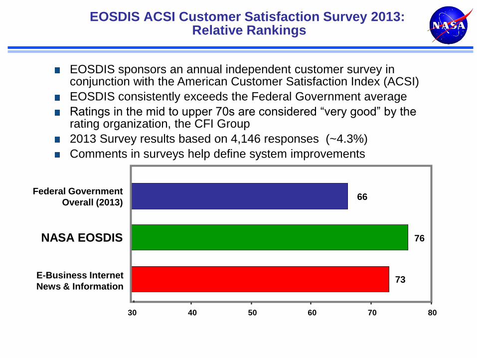
EOSDIS ACSI Customer Satisfaction Survey 2013: Relative Rankings
73
76
66
30 40 50 60 70 80
E-Business Internet
News & Information
NASA EOSDIS
Federal Government
Overall (2013)
EOSDIS sponsors an annual independent customer survey in conjunction with the American Customer Satisfaction Index (ACSI)
EOSDIS consistently exceeds the Federal Government average
Ratings in the mid to upper 70s are considered “very good” by the rating organization, the CFI Group
2013 Survey results based on 4,146 responses (~4.3%)
Comments in surveys help define system improvements
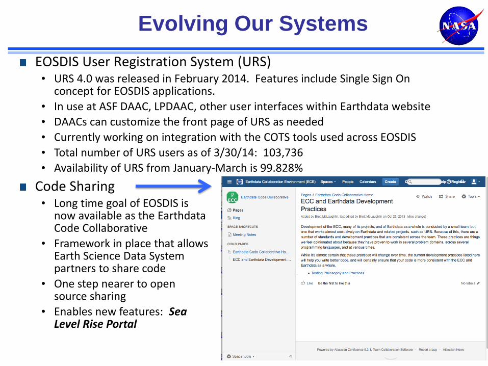
Evolving Our Systems
EOSDIS User Registration System (URS) • URS 4.0 was released in February 2014. Features include Single Sign On
concept for EOSDIS applications.
• In use at ASF DAAC, LPDAAC, other user interfaces within Earthdata website
• DAACs can customize the front page of URS as needed
• Currently working on integration with the COTS tools used across EOSDIS
• Total number of URS users as of 3/30/14: 103,736
• Availability of URS from January-March is 99.828%
4
Code Sharing • Long time goal of EOSDIS is
now available as the Earthdata Code Collaborative
• Framework in place that allows Earth Science Data System partners to share code
• One step nearer to open source sharing
• Enables new features: Sea Level Rise Portal
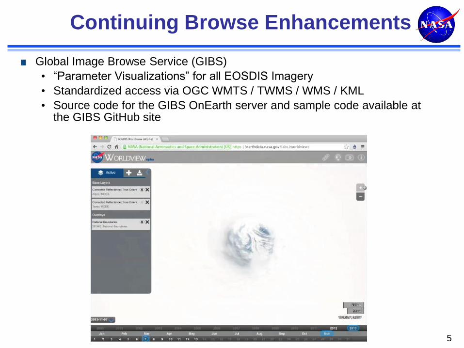
Continuing Browse Enhancements
Global Image Browse Service (GIBS)
• “Parameter Visualizations” for all EOSDIS Imagery
• Standardized access via OGC WMTS / TWMS / WMS / KML
• Source code for the GIBS OnEarth server and sample code available at the GIBS GitHub site
5
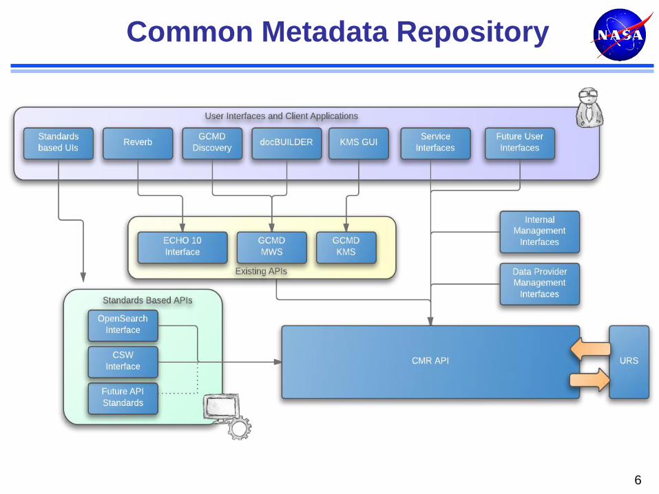
Common Metadata Repository
6
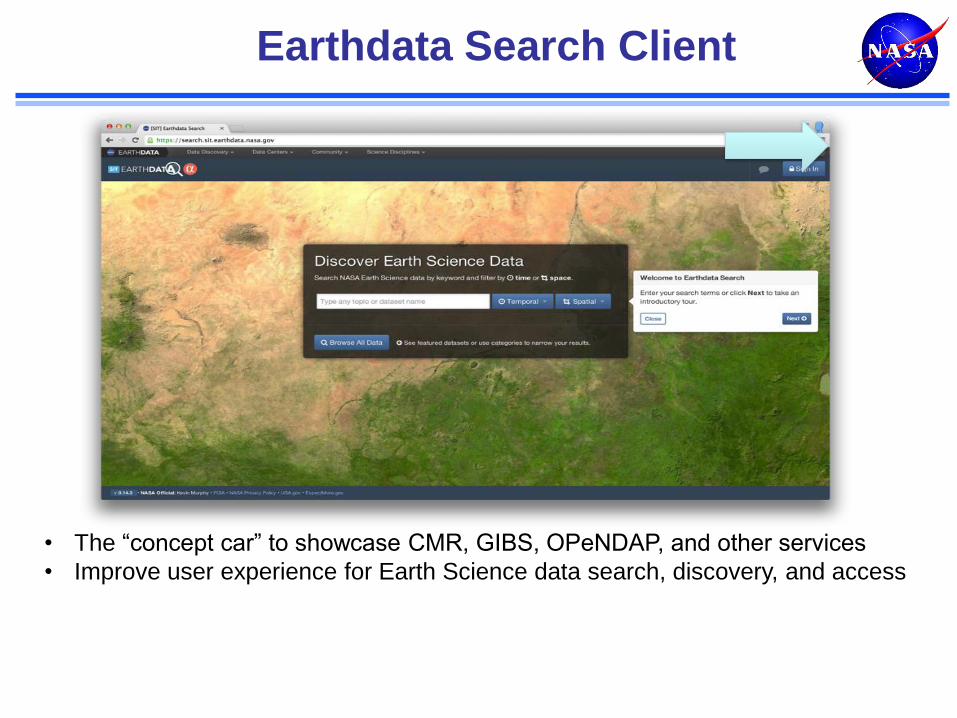
• The “concept car” to showcase CMR, GIBS, OPeNDAP, and other services
• Improve user experience for Earth Science data search, discovery, and access
Earthdata Search Client
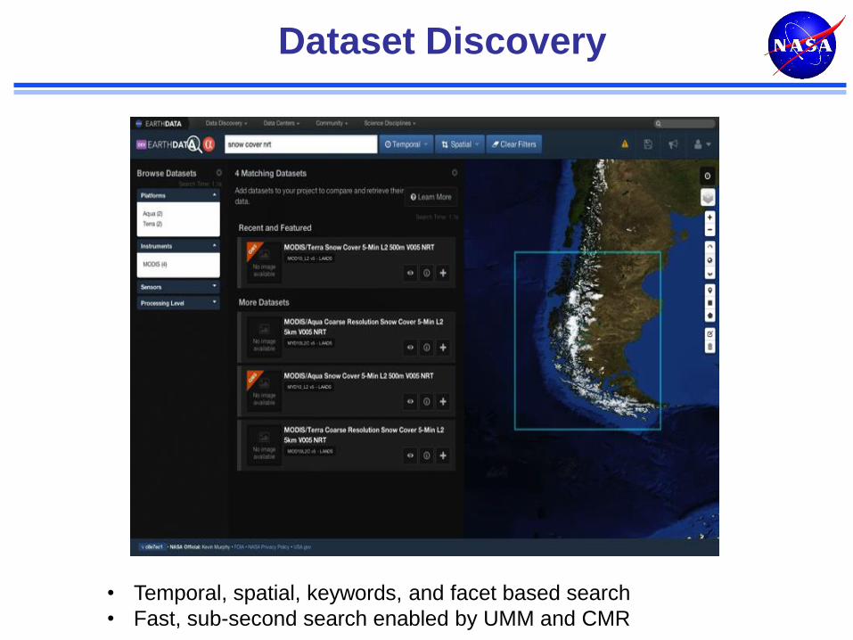
Dataset Discovery
• Temporal, spatial, keywords, and facet based search
• Fast, sub-second search enabled by UMM and CMR
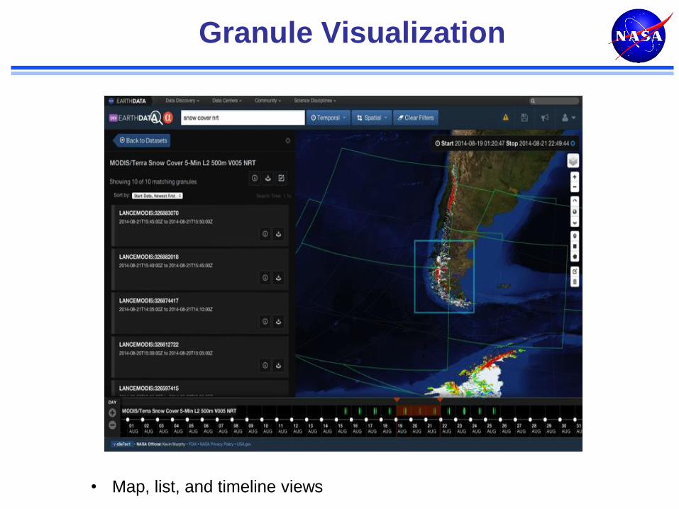
Granule Visualization
• Map, list, and timeline views
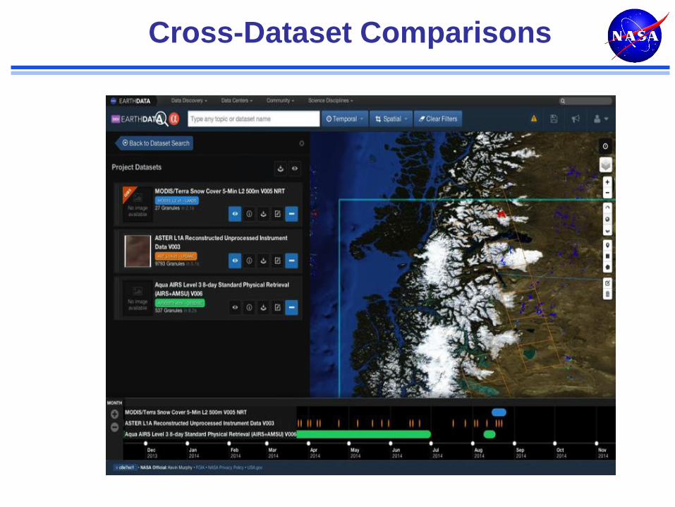
Cross-Dataset Comparisons
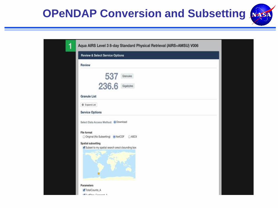
OPeNDAP Conversion and Subsetting
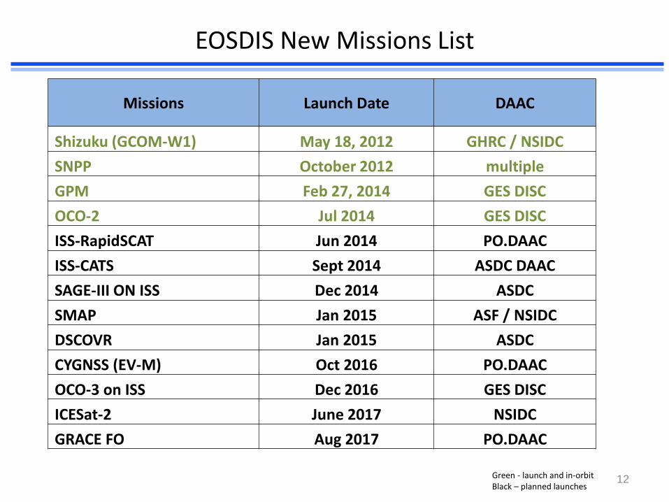
EOSDIS New Missions List
Missions Launch Date DAAC
Shizuku (GCOM-W1) May 18, 2012 GHRC / NSIDC
SNPP October 2012 multiple
GPM Feb 27, 2014 GES DISC
OCO-2 Jul 2014 GES DISC
ISS-RapidSCAT Jun 2014 PO.DAAC
ISS-CATS Sept 2014 ASDC DAAC
SAGE-III ON ISS Dec 2014 ASDC
SMAP Jan 2015 ASF / NSIDC
DSCOVR Jan 2015 ASDC
CYGNSS (EV-M) Oct 2016 PO.DAAC
OCO-3 on ISS Dec 2016 GES DISC
ICESat-2 June 2017 NSIDC
GRACE FO Aug 2017 PO.DAAC
12 Green - launch and in-orbit Black – planned launches
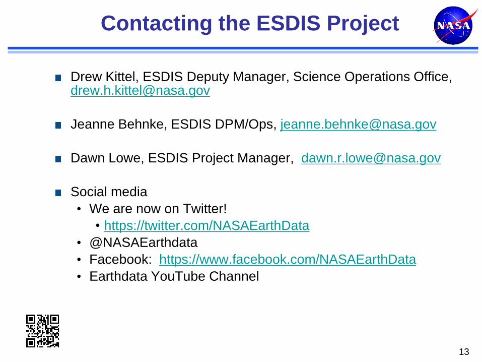
Contacting the ESDIS Project
13
Drew Kittel, ESDIS Deputy Manager, Science Operations Office, [email protected]
Jeanne Behnke, ESDIS DPM/Ops, [email protected]
Dawn Lowe, ESDIS Project Manager, [email protected]
Social media
• We are now on Twitter!
• https://twitter.com/NASAEarthData
• @NASAEarthdata
• Facebook: https://www.facebook.com/NASAEarthData
• Earthdata YouTube Channel
Backup
04/01/14 14
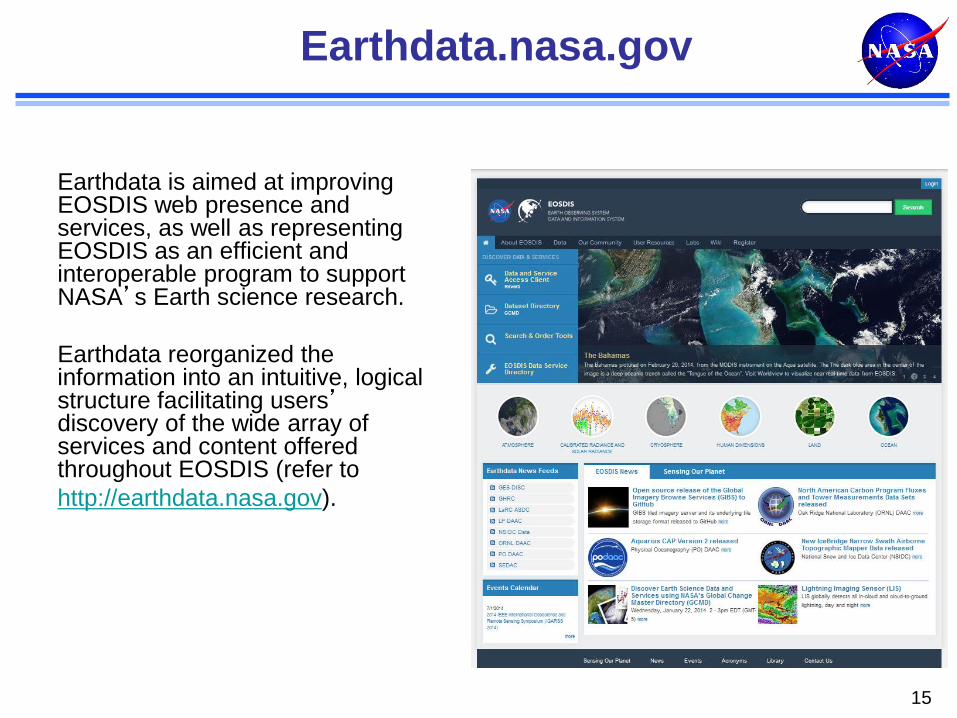
Coherent Web Presence Across the ES Data System Earthdata.nasa.gov
Earthdata is aimed at improving EOSDIS web presence and services, as well as representing EOSDIS as an efficient and interoperable program to support NASA’s Earth science research.
Earthdata reorganized the information into an intuitive, logical structure facilitating users’ discovery of the wide array of services and content offered throughout EOSDIS (refer to
http://earthdata.nasa.gov).
15
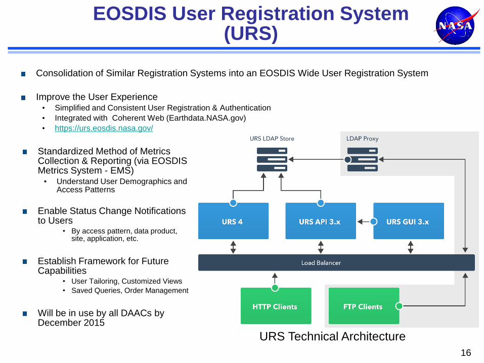
EOSDIS User Registration System (URS)
Consolidation of Similar Registration Systems into an EOSDIS Wide User Registration System
Improve the User Experience • Simplified and Consistent User Registration & Authentication
• Integrated with Coherent Web (Earthdata.NASA.gov)
• https://urs.eosdis.nasa.gov/
16
Standardized Method of Metrics Collection & Reporting (via EOSDIS Metrics System - EMS) • Understand User Demographics and
Access Patterns
Enable Status Change Notifications to Users
• By access pattern, data product, site, application, etc.
Establish Framework for Future Capabilities
• User Tailoring, Customized Views
• Saved Queries, Order Management
Will be in use by all DAACs by December 2015
URS Technical Architecture
Context backup
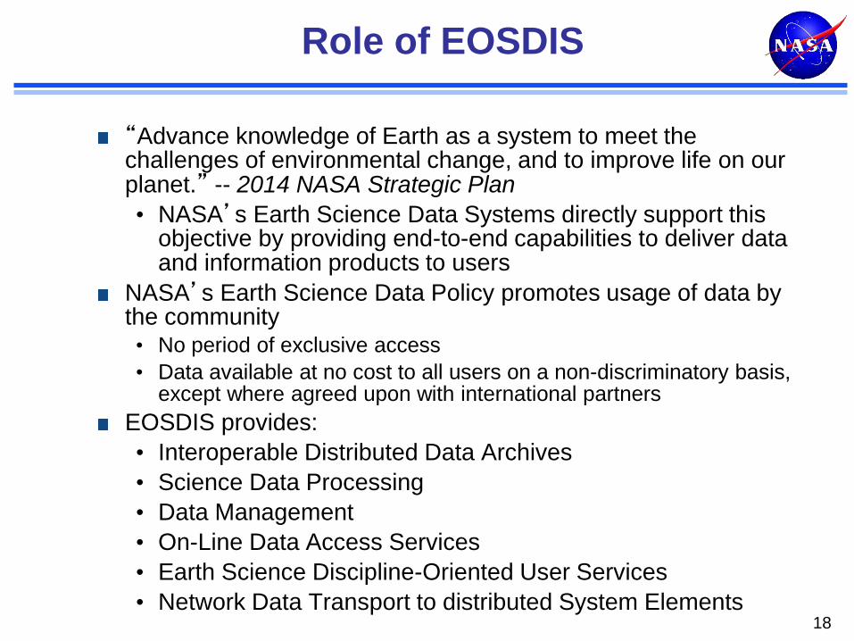
Role of EOSDIS
“Advance knowledge of Earth as a system to meet the challenges of environmental change, and to improve life on our planet.” -- 2014 NASA Strategic Plan
• NASA’s Earth Science Data Systems directly support this objective by providing end-to-end capabilities to deliver data and information products to users
NASA’s Earth Science Data Policy promotes usage of data by the community • No period of exclusive access
• Data available at no cost to all users on a non-discriminatory basis, except where agreed upon with international partners
EOSDIS provides:
• Interoperable Distributed Data Archives
• Science Data Processing
• Data Management
• On-Line Data Access Services
• Earth Science Discipline-Oriented User Services
• Network Data Transport to distributed System Elements 18
19 www.nasa.gov
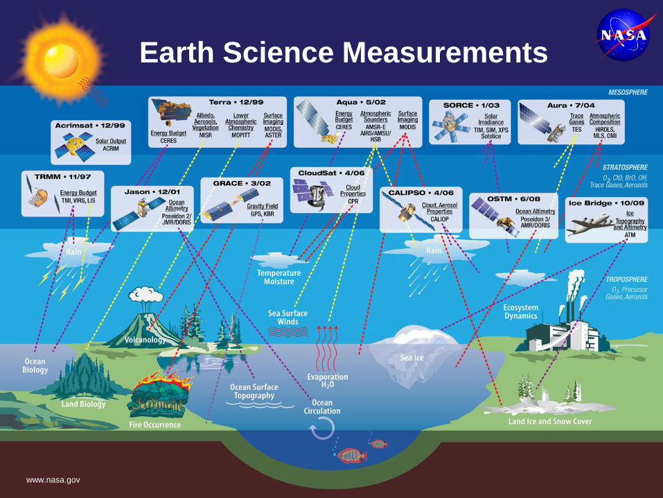
Earth Science Measurements
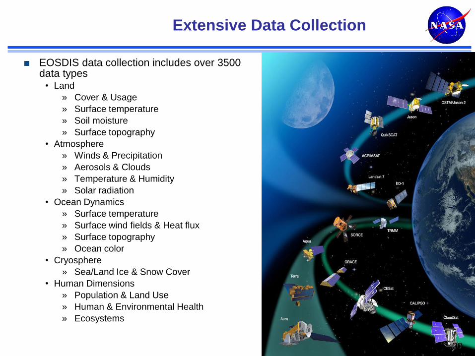
Extensive Data Collection
EOSDIS data collection includes over 3500 data types
• Land
» Cover & Usage
» Surface temperature
» Soil moisture
» Surface topography
• Atmosphere
» Winds & Precipitation
» Aerosols & Clouds
» Temperature & Humidity
» Solar radiation
• Ocean Dynamics
» Surface temperature
» Surface wind fields & Heat flux
» Surface topography
» Ocean color
• Cryosphere
» Sea/Land Ice & Snow Cover
• Human Dimensions
» Population & Land Use
» Human & Environmental Health
» Ecosystems
20
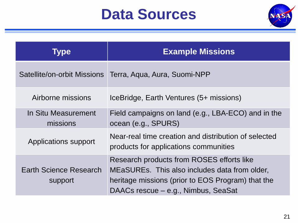
Data Sources
21
Type Example Missions
Satellite/on-orbit Missions Terra, Aqua, Aura, Suomi-NPP
Airborne missions IceBridge, Earth Ventures (5+ missions)
In Situ Measurement
missions
Field campaigns on land (e.g., LBA-ECO) and in the
ocean (e.g., SPURS)
Applications support Near-real time creation and distribution of selected
products for applications communities
Earth Science Research
support
Research products from ROSES efforts like
MEaSUREs. This also includes data from older,
heritage missions (prior to EOS Program) that the
DAACs rescue – e.g., Nimbus, SeaSat

Mission Operations Science Operations
Earth Science Data Operations
Data Acquisition
Flight Operations, Data Capture,
Initial Processing, Backup Archive
Data Transport to
Data Centers/ SIPSs
Science Data Processing, Data Management, Interoperable Data
Archive, and Distribution
Distribution and
Data Access
NASA Integrated Services Network (NISN)
Mission Services
Research
Education
Value-Added Providers
Earth System Models
International Partners
Decision Support Systems
Infra- structure
(Search, Order,
Distribution)
Tracking and Data Relay Satellite (TDRS)
Instrument Teams and Science
Investigator-led Processing Systems
(SIPSs)
White Sands Complex (WSC)
EOS Polar Ground Stations
Direct Broadcast (DB)
Direct Broadcast/ Direct Readout
Stations
EOSDIS Data Centers
EOS Data Operations System (EDOS) Data Processing
EOS Operations Center (EOC)
Mission Control
EOSSpacecraft
Interagency Data Centers
23
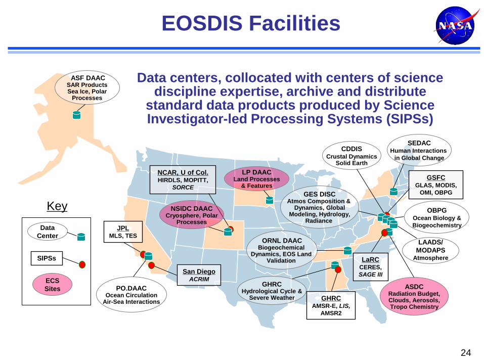
EOSDIS Facilities
24
Data centers, collocated with centers of science discipline expertise, archive and distribute
standard data products produced by Science Investigator-led Processing Systems (SIPSs)
ASF DAAC SAR Products Sea Ice, Polar
Processes
SEDAC Human Interactions
in Global Change
LP DAAC Land Processes
& Features
PO.DAAC Ocean Circulation
Air-Sea Interactions
ASDC Radiation Budget, Clouds, Aerosols, Tropo Chemistry
ORNL DAAC Biogeochemical
Dynamics, EOS Land Validation
GES DISC Atmos Composition &
Dynamics, Global Modeling, Hydrology,
Radiance
LAADS/
MODAPS Atmosphere
OBPG Ocean Biology &
Biogeochemistry
GHRC Hydrological Cycle &
Severe Weather
CDDIS Crustal Dynamics
Solid Earth
NCAR, U of Col. HIRDLS, MOPITT,
SORCE
GSFC GLAS, MODIS,
OMI, OBPG
LaRC CERES,
SAGE III
GHRC AMSR-E, LIS,
AMSR2
JPL MLS, TES
San Diego ACRIM
NSIDC DAAC Cryosphere, Polar
Processes
SIPSs
Key
Data
Center
ECS
Sites
Science Processing Systems for EOSDIS
Microwave Limb Sounder
(MLS) SIPS
Ozone Monitoring Instrument (OMI) SIPS
Atmospheric Infrared
Sounder (AIRS) at GES DISC
Ocean Data Processing System
(OCDPS) SIPS
Active Cavity Radiometer Irradiance Monitor
(ACRIM) SCF
Solar Radiation and Climate Experiment (SORCE) SCF
Lightning Imaging Sensor (LIS) SCF
Clouds and the Earth's Radiant Energy System
(CERES) at ASDC
EOSDIS science processing systems
(SIPSs, SCFs, and DAAC-based)
perform forward processing of standard
products, and reprocess data to
incorporate algorithm improvements.
Production
Data for ECS
DAACs
Tropospheric Emission
Spectrometer (TES) SIPS
Measurements of Pollution in the
Troposphere (MOPITT) SIPS
Advanced Spaceborne Thermal Emission
and Reflection Radiometer (ASTER)
at LP DAAC
MODIS Adaptive Processing System
(MODAPS) SIPS
Multi-angle Imaging Spectro-
Radiometer (MISR)
at ASDC
Advanced Microwave
Scanning Radiometer
for EOS (AMSR2) SIPS
Stratospheric Aerosol and Gas
Experiment (SAGE III) SCF

EOSDIS ACSI Customer Satisfaction Survey 2013: Relative Rankings
73
76
66
30 40 50 60 70 80
E-Business Internet
News & Information
NASA EOSDIS
Federal Government
Overall (2013)
EOSDIS sponsors an annual independent customer survey in conjunction with the American Customer Satisfaction Index (ACSI)
EOSDIS consistently exceeds the Federal Government average
Ratings in the mid to upper 70s are considered “very good” by the rating organization, the CFI Group
2013 Survey results based on 4,146 responses (~4.3%)
Comments in surveys help define system improvements
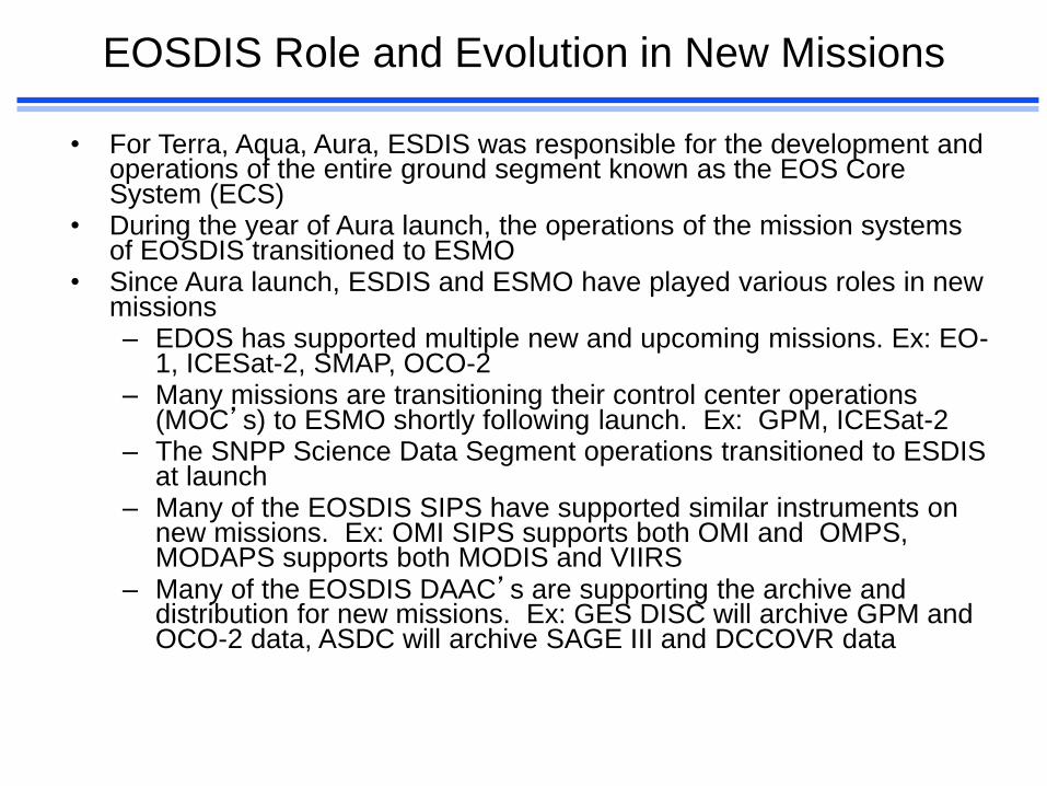
EOSDIS Role and Evolution in New Missions
• For Terra, Aqua, Aura, ESDIS was responsible for the development and operations of the entire ground segment known as the EOS Core System (ECS)
• During the year of Aura launch, the operations of the mission systems of EOSDIS transitioned to ESMO
• Since Aura launch, ESDIS and ESMO have played various roles in new missions – EDOS has supported multiple new and upcoming missions. Ex: EO-
1, ICESat-2, SMAP, OCO-2 – Many missions are transitioning their control center operations
(MOC’s) to ESMO shortly following launch. Ex: GPM, ICESat-2 – The SNPP Science Data Segment operations transitioned to ESDIS
at launch – Many of the EOSDIS SIPS have supported similar instruments on
new missions. Ex: OMI SIPS supports both OMI and OMPS, MODAPS supports both MODIS and VIIRS
– Many of the EOSDIS DAAC’s are supporting the archive and distribution for new missions. Ex: GES DISC will archive GPM and OCO-2 data, ASDC will archive SAGE III and DCCOVR data
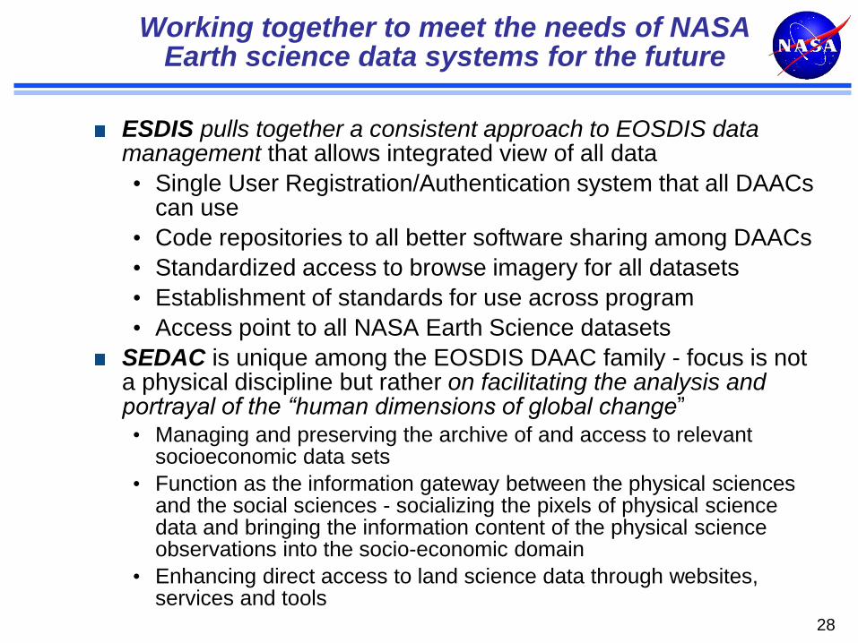
Working together to meet the needs of NASA Earth science data systems for the future
ESDIS pulls together a consistent approach to EOSDIS data management that allows integrated view of all data
• Single User Registration/Authentication system that all DAACs can use
• Code repositories to all better software sharing among DAACs
• Standardized access to browse imagery for all datasets
• Establishment of standards for use across program
• Access point to all NASA Earth Science datasets
SEDAC is unique among the EOSDIS DAAC family - focus is not a physical discipline but rather on facilitating the analysis and portrayal of the “human dimensions of global change” • Managing and preserving the archive of and access to relevant
socioeconomic data sets
• Function as the information gateway between the physical sciences and the social sciences - socializing the pixels of physical science data and bringing the information content of the physical science observations into the socio-economic domain
• Enhancing direct access to land science data through websites, services and tools
28
Webinars & Social Media
04/01/14 29
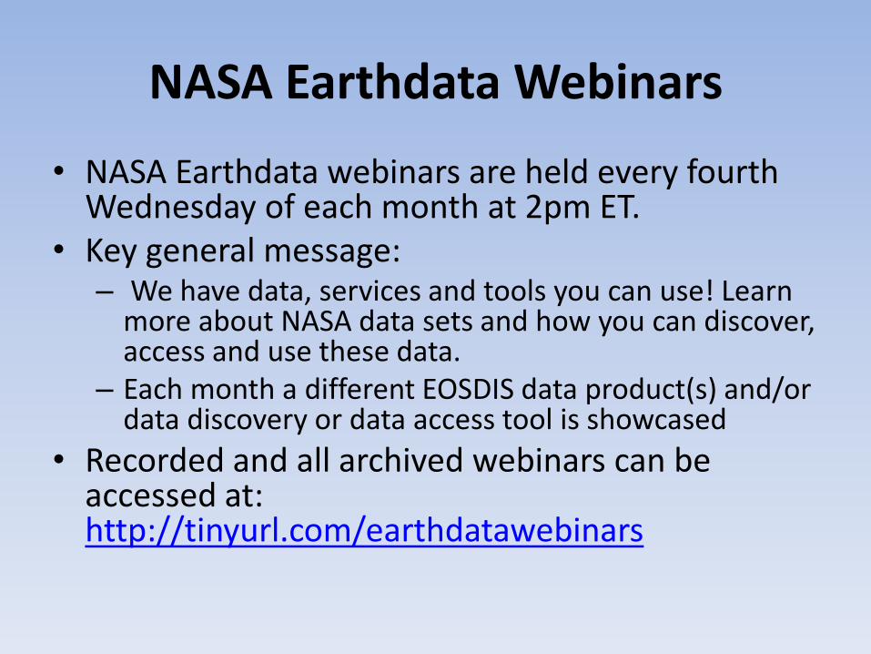
NASA Earthdata Webinars
• NASA Earthdata webinars are held every fourth Wednesday of each month at 2pm ET.
• Key general message: – We have data, services and tools you can use! Learn
more about NASA data sets and how you can discover, access and use these data.
– Each month a different EOSDIS data product(s) and/or data discovery or data access tool is showcased
• Recorded and all archived webinars can be accessed at: http://tinyurl.com/earthdatawebinars
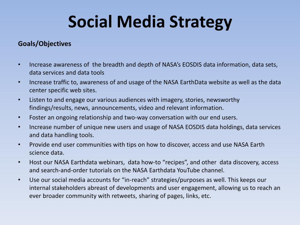
Social Media Strategy Goals/Objectives
• Increase awareness of the breadth and depth of NASA’s EOSDIS data information, data sets, data services and data tools
• Increase traffic to, awareness of and usage of the NASA EarthData website as well as the data center specific web sites.
• Listen to and engage our various audiences with imagery, stories, newsworthy findings/results, news, announcements, video and relevant information.
• Foster an ongoing relationship and two-way conversation with our end users.
• Increase number of unique new users and usage of NASA EOSDIS data holdings, data services and data handling tools.
• Provide end user communities with tips on how to discover, access and use NASA Earth science data.
• Host our NASA Earthdata webinars, data how-to “recipes”, and other data discovery, access and search-and-order tutorials on the NASA Earthdata YouTube channel.
• Use our social media accounts for “in-reach” strategies/purposes as well. This keeps our internal stakeholders abreast of developments and user engagement, allowing us to reach an ever broader community with retweets, sharing of pages, links, etc.
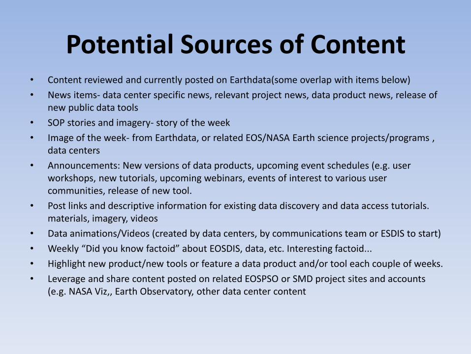
Potential Sources of Content • Content reviewed and currently posted on Earthdata(some overlap with items below)
• News items- data center specific news, relevant project news, data product news, release of new public data tools
• SOP stories and imagery- story of the week
• Image of the week- from Earthdata, or related EOS/NASA Earth science projects/programs , data centers
• Announcements: New versions of data products, upcoming event schedules (e.g. user workshops, new tutorials, upcoming webinars, events of interest to various user communities, release of new tool.
• Post links and descriptive information for existing data discovery and data access tutorials. materials, imagery, videos
• Data animations/Videos (created by data centers, by communications team or ESDIS to start)
• Weekly “Did you know factoid” about EOSDIS, data, etc. Interesting factoid...
• Highlight new product/new tools or feature a data product and/or tool each couple of weeks.
• Leverage and share content posted on related EOSPSO or SMD project sites and accounts (e.g. NASA Viz,, Earth Observatory, other data center content
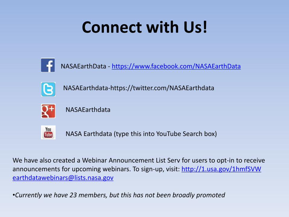
Connect with Us!
NASAEarthData - https://www.facebook.com/NASAEarthData
NASAEarthdata-https://twitter.com/NASAEarthdata
NASAEarthdata
NASA Earthdata (type this into YouTube Search box)
We have also created a Webinar Announcement List Serv for users to opt-in to receive announcements for upcoming webinars. To sign-up, visit: http://1.usa.gov/1hmfSVW [email protected] •Currently we have 23 members, but this has not been broadly promoted
UWGs
04/01/14 34
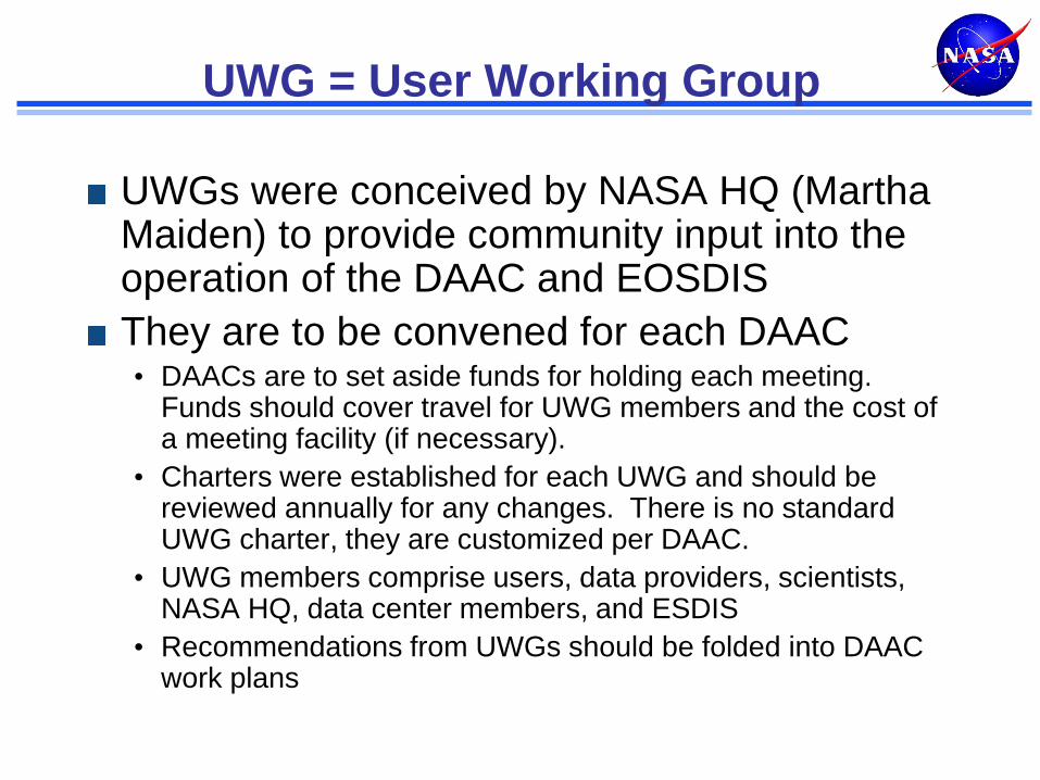
UWG = User Working Group
UWGs were conceived by NASA HQ (Martha Maiden) to provide community input into the operation of the DAAC and EOSDIS
They are to be convened for each DAAC • DAACs are to set aside funds for holding each meeting.
Funds should cover travel for UWG members and the cost of a meeting facility (if necessary).
• Charters were established for each UWG and should be reviewed annually for any changes. There is no standard UWG charter, they are customized per DAAC.
• UWG members comprise users, data providers, scientists, NASA HQ, data center members, and ESDIS
• Recommendations from UWGs should be folded into DAAC work plans
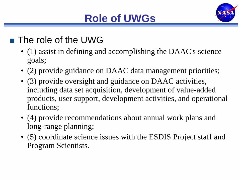
Role of UWGs
The role of the UWG • (1) assist in defining and accomplishing the DAAC's science
goals;
• (2) provide guidance on DAAC data management priorities;
• (3) provide oversight and guidance on DAAC activities, including data set acquisition, development of value-added products, user support, development activities, and operational functions;
• (4) provide recommendations about annual work plans and long-range planning;
• (5) coordinate science issues with the ESDIS Project staff and Program Scientists.
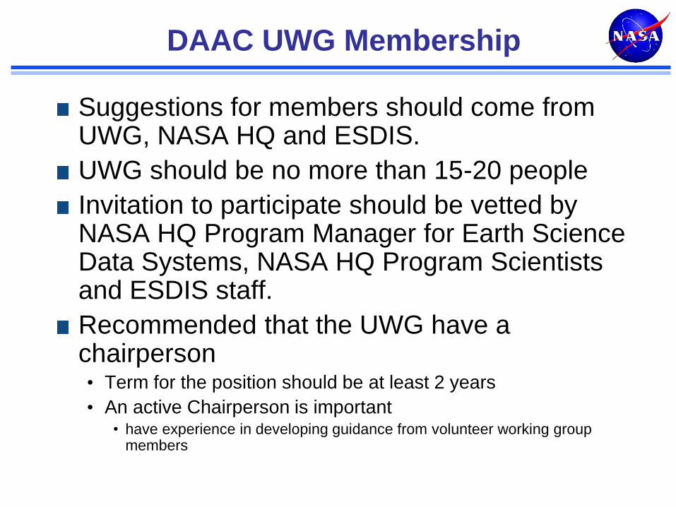
DAAC UWG Membership
Suggestions for members should come from UWG, NASA HQ and ESDIS.
UWG should be no more than 15-20 people
Invitation to participate should be vetted by NASA HQ Program Manager for Earth Science Data Systems, NASA HQ Program Scientists and ESDIS staff.
Recommended that the UWG have a chairperson • Term for the position should be at least 2 years
• An active Chairperson is important • have experience in developing guidance from volunteer working group
members
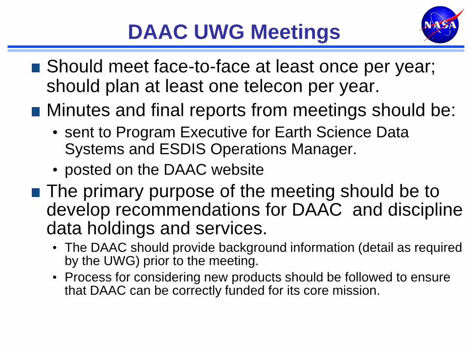
DAAC UWG Meetings
Should meet face-to-face at least once per year; should plan at least one telecon per year.
Minutes and final reports from meetings should be: • sent to Program Executive for Earth Science Data
Systems and ESDIS Operations Manager.
• posted on the DAAC website
The primary purpose of the meeting should be to develop recommendations for DAAC and discipline data holdings and services. • The DAAC should provide background information (detail as required
by the UWG) prior to the meeting.
• Process for considering new products should be followed to ensure that DAAC can be correctly funded for its core mission.
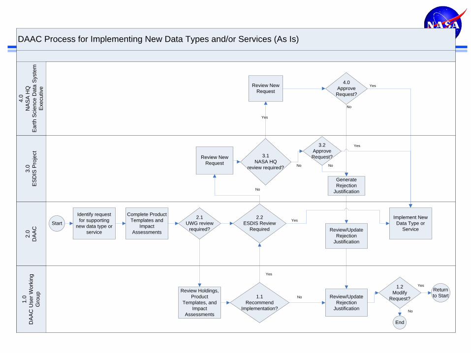
DAAC Process for Implementing New Data Types and/or Services (As Is)
3.0
ES
DIS
Pro
ject
2.0
DA
AC
1.0
DA
AC
Use
r W
ork
ing
Gro
up
4.0
NA
SA
HQ
Ea
rth
Scie
nce
Da
ta S
yste
m
Exe
cu
tive
Identify request
for supporting
new data type or
service
2.2
ESDIS Review
Required
Implement New
Data Type or
Service
Review Holdings,
Product
Templates, and
Impact
Assessments
Complete Product
Templates and
Impact
Assessments
Review New
Request
3.1
NASA HQ
review required?
Generate
Rejection
Justification
Review/Update
Rejection
Justification
3.2
Approve
Request?
Review New
Request
4.0
Approve
Request?
Review/Update
Rejection
Justification
1.2
Modify
Request?
Return
to Start
End
StartYes
No
Yes
No
Yes
No
No
Yes
Yes
No
2.1
UWG review
required?
1.1
Recommend
Implementation?
Yes
No
Data Center
Operations
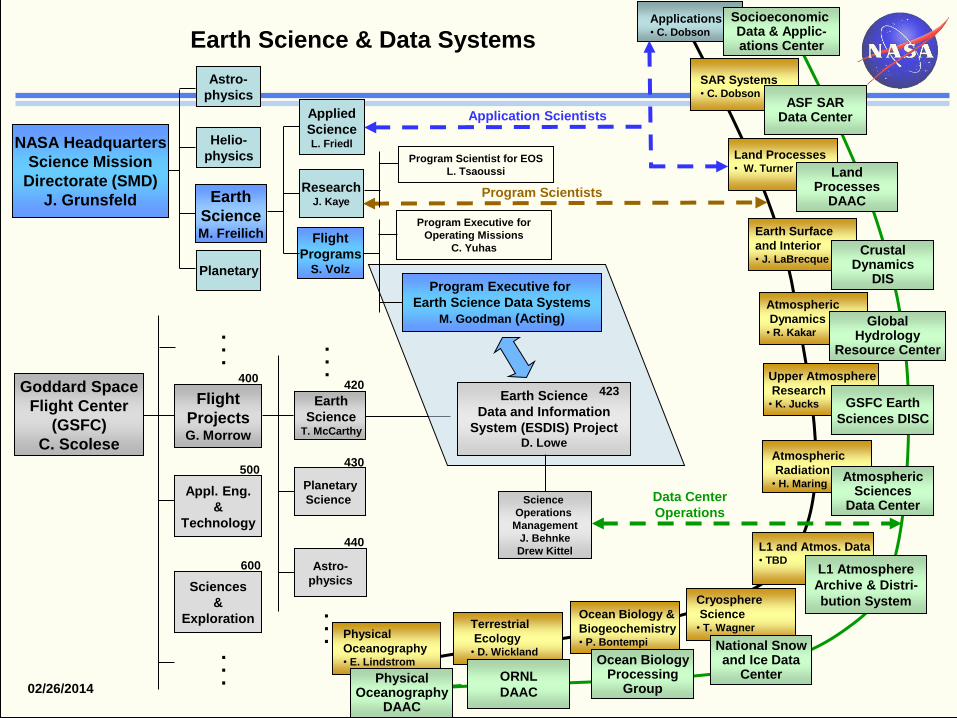
NASA Headquarters
Science Mission
Directorate (SMD)
J. Grunsfeld
Astro-
physics
Helio-
physics
Planetary
Research J. Kaye
Applied
Science L. Friedl
Flight
Programs S. Volz
Program Executive for
Earth Science Data Systems
M. Goodman (Acting)
Program Executive for
Operating Missions
C. Yuhas
Earth Science
Data and Information
System (ESDIS) Project D. Lowe
Science
Operations
Management
J. Behnke
Drew Kittel
Flight
Projects G. Morrow
Appl. Eng.
&
Technology
Sciences
&
Exploration
Planetary
Science
Astro-
physics
Earth
Science T. McCarthy
400
500
600
423
.
.
.
.
.
.
Terrestrial
Ecology • D. Wickland
ORNL
DAAC
Program Scientists
Physical
Oceanography • E. Lindstrom
Physical Oceanography
DAAC
Atmospheric
Dynamics • R. Kakar
GSFC Earth
Sciences DISC
Ocean Biology &
Biogeochemistry • P. Bontempi
Earth Surface
and Interior • J. LaBrecque
Crustal Dynamics
DIS
Cryosphere
Science • T. Wagner
National Snow and Ice Data
Center
420
430
440
.
.
.
.
.
.
Earth Science & Data Systems
Upper Atmosphere
Research • K. Jucks
Global Hydrology
Resource Center
Ocean Biology Processing
Group
SAR Systems • C. Dobson
ASF SAR Data Center
Socioeconomic Data & Applic- ations Center
Applications • C. Dobson
L1 and Atmos. Data • TBD
L1 Atmosphere
Archive & Distri-
bution System
Earth
Science M. Freilich
Application Scientists
Land Processes • W. Turner Land
Processes DAAC
Atmospheric
Radiation • H. Maring
Atmospheric Sciences
Data Center
02/26/2014
Program Scientist for EOS
L. Tsaoussi
Goddard Space
Flight Center
(GSFC)
C. Scolese
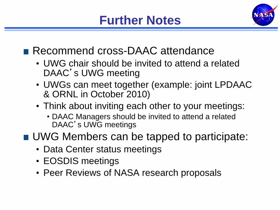
Further Notes
Recommend cross-DAAC attendance • UWG chair should be invited to attend a related
DAAC’s UWG meeting
• UWGs can meet together (example: joint LPDAAC & ORNL in October 2010)
• Think about inviting each other to your meetings: • DAAC Managers should be invited to attend a related
DAAC’s UWG meetings
UWG Members can be tapped to participate: • Data Center status meetings
• EOSDIS meetings
• Peer Reviews of NASA research proposals
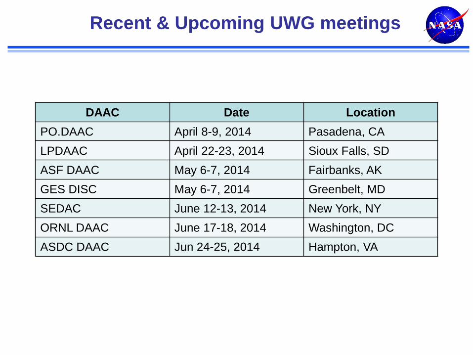
Recent & Upcoming UWG meetings
DAAC Date Location
PO.DAAC April 8-9, 2014 Pasadena, CA
LPDAAC April 22-23, 2014 Sioux Falls, SD
ASF DAAC May 6-7, 2014 Fairbanks, AK
GES DISC May 6-7, 2014 Greenbelt, MD
SEDAC June 12-13, 2014 New York, NY
ORNL DAAC June 17-18, 2014 Washington, DC
ASDC DAAC Jun 24-25, 2014 Hampton, VA