Embed Size (px)
Citation preview
ESA UNCLASSIFIED – Releasable to the Public
Prepared by EOP-PE CFI Team Reference PE-ID-ESA-GS-584 Issue 1 Revision 2 Date of Issue 15-06-2018 Status Final Document Type Format Specification
estec
European Space Research
and Technology Centre
Keplerlaan 1
2201 AZ Noordwijk
The Netherlands
T +31 (0)71 565 6565
F +31 (0)71 565 6040
www.esa.int
Earth Observation Mission Software File Format Specification
ESA UNCLASSIFIED – Releasable to the Public
Page 2/44 PE-ID-ESA-GS-584 - Earth Observation Mission Software File Format Specification Date: 15-06-2018, Issue: 1, Revision: 2
Title Earth Observation Mission Software File Format Specification Issue 1 Revision 2
Author EOP-PE CFI Team Date 15-06-2018
Approved by Michele Zundo Date 15-06-2018
Reason for change Issue Revision Date First Issue 1 0 16/2/2017
Updated Orbit Scenario File Format and Version; Clarification about File Format Version; Added Compliance to legacy File Format Standards; Minor changes in examples.
1 1 21/3/2017
Review corresponding to release of EO CFI 4.15 1 2 15-06-2018
Issue 1 Revision 0 Reason for change Date Pages Paragraph(s) First Issue 16/2/2017 All All
Issue 1 Revision 1 Reason for change Date Pages Paragraph(s) Updated Orbit Scenario File Format and Version;
Clarification about File Format Version; Added Compliance to legacy File Format Standards Minor changes in examples.
21/3/2017 - - - -
1, 3.2 1 2 3.11
Issue 1 Revision 2 Reason for change Date Pages Paragraph(s) Updated Orbit State Vector File Schema Name;
Updated Attitude Definition File Schema Version; Updated Orbit Scenario File Format and Version; Updated Swath Definition File Format and Version
19/6/2018 - 2 2 2, 3.2 2, 3.6
ESA UNCLASSIFIED – Releasable to the Public
Page 3/44 PE-ID-ESA-GS-584 - Earth Observation Mission Software File Format Specification Date: 15-06-2018, Issue: 1, Revision: 2
Table of contents:
1 INTRODUCTION................................................................................................................................... 42 COMPLIANCE WITH FILE FORMAT STANDARD ............................................................................... 53 FILE FORMAT SPECIFICATION .......................................................................................................... 83.1 Orbit State Vector File .......................................................................................................................... 83.1.1 Variable Header ................................................................................................................................. 83.1.2 Data Block ......................................................................................................................................... 83.1.3 Schema Reference .......................................................................................................................... 103.2 Orbit Scenario File ............................................................................................................................. 113.2.1 Variable Header ............................................................................................................................... 113.2.2 Data Block ....................................................................................................................................... 113.2.3 Schema Reference .......................................................................................................................... 133.3 Satellite Configuration File .................................................................................................................. 153.3.1 Variable Header ............................................................................................................................... 153.3.2 Data Block ....................................................................................................................................... 153.3.3 Schema Reference .......................................................................................................................... 163.4 Attitude Quaternion File ...................................................................................................................... 183.4.1 Variable Header ............................................................................................................................... 183.4.2 Data Block ....................................................................................................................................... 183.4.3 Schema Reference .......................................................................................................................... 193.5 Attitude Roll Pitch Yaw File ................................................................................................................ 213.5.1 Variable Header ............................................................................................................................... 213.5.2 Data Block ....................................................................................................................................... 213.5.3 Schema Reference .......................................................................................................................... 223.6 Swath Definition File .......................................................................................................................... 233.6.1 Variable Header ............................................................................................................................... 233.6.2 Data Block ....................................................................................................................................... 233.6.3 Schema Reference .......................................................................................................................... 283.7 Swath Template File .......................................................................................................................... 293.7.1 Variable Header ............................................................................................................................... 293.7.2 Data Block ....................................................................................................................................... 303.7.3 Schema Reference .......................................................................................................................... 323.8 Zone Database File ............................................................................................................................ 333.8.1 Variable Header ............................................................................................................................... 333.8.2 Data Block ....................................................................................................................................... 333.8.3 Schema Reference .......................................................................................................................... 343.9 Station Database File ......................................................................................................................... 353.9.1 Variable Header ............................................................................................................................... 353.9.2 Data Block ....................................................................................................................................... 353.9.3 Schema Reference .......................................................................................................................... 373.10Attitude Definition File ........................................................................................................................ 383.10.1Variable Header ............................................................................................................................... 383.10.2Data Block ....................................................................................................................................... 383.10.3Schema Reference .......................................................................................................................... 403.11Field of View Configuration File .......................................................................................................... 423.11.1Variable Header ............................................................................................................................... 423.11.2Data Block ....................................................................................................................................... 423.11.3Schema Reference .......................................................................................................................... 43
ESA UNCLASSIFIED – Releasable to the Public
Page 4/44 PE-ID-ESA-GS-584 - Earth Observation Ground Segment File Format Specification Date: 21/3/2017, Issue: 1, Revision: 1 2
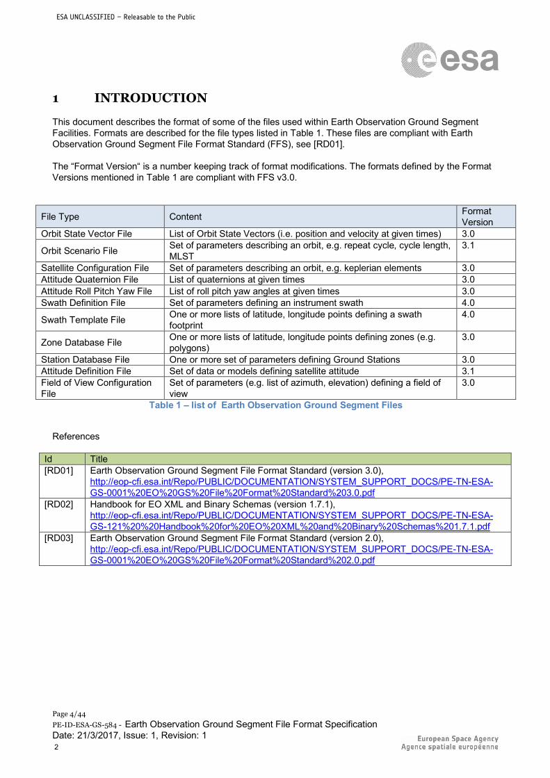
1 INTRODUCTION
This document describes the format of some of the files used within Earth Observation Ground Segment Facilities. Formats are described for the file types listed in Table 1. These files are compliant with Earth Observation Ground Segment File Format Standard (FFS), see [RD01]. The “Format Version“ is a number keeping track of format modifications. The formats defined by the Format Versions mentioned in Table 1 are compliant with FFS v3.0.
File Type Content Format Version
Orbit State Vector File List of Orbit State Vectors (i.e. position and velocity at given times) 3.0
Orbit Scenario File Set of parameters describing an orbit, e.g. repeat cycle, cycle length, MLST
3.1
Satellite Configuration File Set of parameters describing an orbit, e.g. keplerian elements 3.0 Attitude Quaternion File List of quaternions at given times 3.0 Attitude Roll Pitch Yaw File List of roll pitch yaw angles at given times 3.0 Swath Definition File Set of parameters defining an instrument swath 4.0
Swath Template File One or more lists of latitude, longitude points defining a swath footprint
4.0
Zone Database File One or more lists of latitude, longitude points defining zones (e.g. polygons)
3.0
Station Database File One or more set of parameters defining Ground Stations 3.0 Attitude Definition File Set of data or models defining satellite attitude 3.1 Field of View Configuration File
Set of parameters (e.g. list of azimuth, elevation) defining a field of view
3.0
Table 1 – list of Earth Observation Ground Segment Files
References
Id Title [RD01] Earth Observation Ground Segment File Format Standard (version 3.0),
http://eop-cfi.esa.int/Repo/PUBLIC/DOCUMENTATION/SYSTEM_SUPPORT_DOCS/PE-TN-ESA-GS-0001%20EO%20GS%20File%20Format%20Standard%203.0.pdf
[RD02] Handbook for EO XML and Binary Schemas (version 1.7.1), http://eop-cfi.esa.int/Repo/PUBLIC/DOCUMENTATION/SYSTEM_SUPPORT_DOCS/PE-TN-ESA-GS-121%20%20Handbook%20for%20EO%20XML%20and%20Binary%20Schemas%201.7.1.pdf
[RD03] Earth Observation Ground Segment File Format Standard (version 2.0), http://eop-cfi.esa.int/Repo/PUBLIC/DOCUMENTATION/SYSTEM_SUPPORT_DOCS/PE-TN-ESA-GS-0001%20EO%20GS%20File%20Format%20Standard%202.0.pdf
ESA UNCLASSIFIED – Releasable to the Public
Page 5/44 PE-ID-ESA-GS-584 - Earth Observation Mission Software File Format Specification Date: 15-06-2018, Issue: 1, Revision: 2
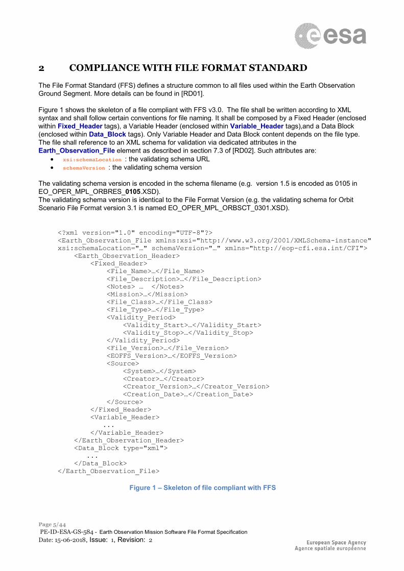
2 COMPLIANCE WITH FILE FORMAT STANDARD
The File Format Standard (FFS) defines a structure common to all files used within the Earth Observation Ground Segment. More details can be found in [RD01]. Figure 1 shows the skeleton of a file compliant with FFS v3.0. The file shall be written according to XML syntax and shall follow certain conventions for file naming. It shall be composed by a Fixed Header (enclosed within Fixed_Header tags), a Variable Header (enclosed within Variable_Header tags),and a Data Block (enclosed within Data_Block tags). Only Variable Header and Data Block content depends on the file type. The file shall reference to an XML schema for validation via dedicated attributes in the Earth_Observation_File element as described in section 7.3 of [RD02]. Such attributes are:
• xsi:schemaLocation : the validating schema URL • schemaVersion : the validating schema version
The validating schema version is encoded in the schema filename (e.g. version 1.5 is encoded as 0105 in EO_OPER_MPL_ORBRES_0105.XSD). The validating schema version is identical to the File Format Version (e.g. the validating schema for Orbit Scenario File Format version 3.1 is named EO_OPER_MPL_ORBSCT_0301.XSD).
<?xml version="1.0" encoding="UTF-8"?> <Earth_Observation_File xmlns:xsi="http://www.w3.org/2001/XMLSchema-instance" xsi:schemaLocation="…" schemaVersion="…" xmlns="http://eop-cfi.esa.int/CFI"> <Earth_Observation_Header> <Fixed_Header> <File_Name>…</File_Name> <File_Description>…</File_Description> <Notes> … </Notes> <Mission>…</Mission> <File_Class>…</File_Class> <File_Type>…</File_Type> <Validity_Period> <Validity_Start>…</Validity_Start> <Validity_Stop>…</Validity_Stop> </Validity_Period> <File_Version>…</File_Version> <EOFFS_Version>…</EOFFS_Version> <Source> <System>…</System> <Creator>…</Creator> <Creator_Version>…</Creator_Version> <Creation_Date>…</Creation_Date> </Source> </Fixed_Header> <Variable_Header> ... </Variable_Header> </Earth_Observation_Header> <Data_Block type="xml"> ... </Data_Block> </Earth_Observation_File>
Figure 1 – Skeleton of file compliant with FFS
ESA UNCLASSIFIED – Releasable to the Public
Page 6/44 PE-ID-ESA-GS-584 - Earth Observation Mission Software File Format Specification Date: 15-06-2018, Issue: 1, Revision: 2
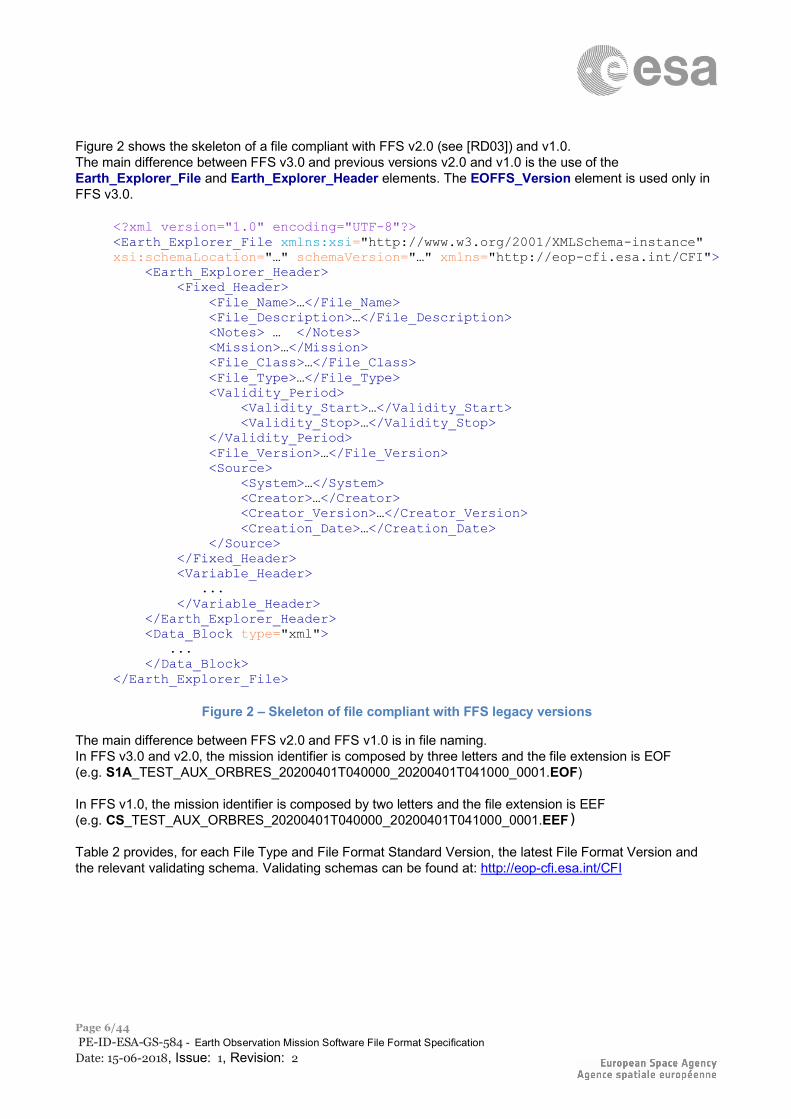
Figure 2 shows the skeleton of a file compliant with FFS v2.0 (see [RD03]) and v1.0. The main difference between FFS v3.0 and previous versions v2.0 and v1.0 is the use of the Earth_Explorer_File and Earth_Explorer_Header elements. The EOFFS_Version element is used only in FFS v3.0.
<?xml version="1.0" encoding="UTF-8"?> <Earth_Explorer_File xmlns:xsi="http://www.w3.org/2001/XMLSchema-instance" xsi:schemaLocation="…" schemaVersion="…" xmlns="http://eop-cfi.esa.int/CFI"> <Earth_Explorer_Header> <Fixed_Header> <File_Name>…</File_Name> <File_Description>…</File_Description> <Notes> … </Notes> <Mission>…</Mission> <File_Class>…</File_Class> <File_Type>…</File_Type> <Validity_Period> <Validity_Start>…</Validity_Start> <Validity_Stop>…</Validity_Stop> </Validity_Period> <File_Version>…</File_Version> <Source> <System>…</System> <Creator>…</Creator> <Creator_Version>…</Creator_Version> <Creation_Date>…</Creation_Date> </Source> </Fixed_Header> <Variable_Header> ... </Variable_Header> </Earth_Explorer_Header> <Data_Block type="xml"> ... </Data_Block> </Earth_Explorer_File>
Figure 2 – Skeleton of file compliant with FFS legacy versions
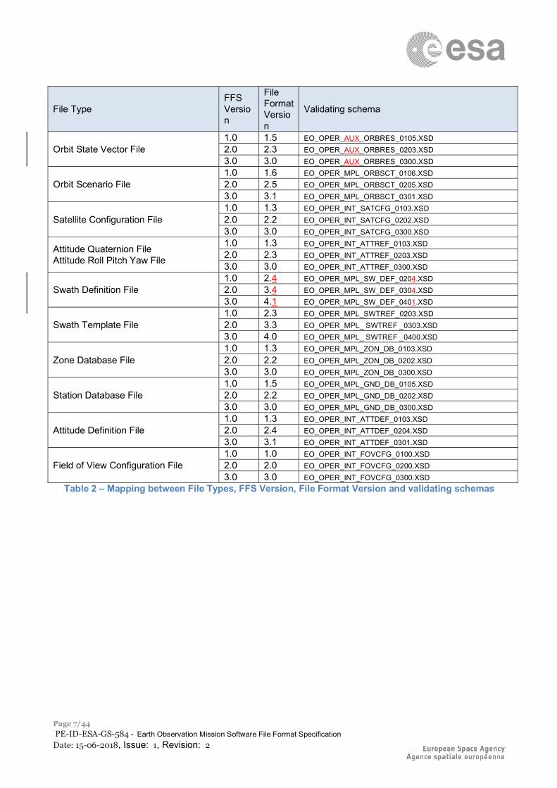
The main difference between FFS v2.0 and FFS v1.0 is in file naming. In FFS v3.0 and v2.0, the mission identifier is composed by three letters and the file extension is EOF (e.g. S1A_TEST_AUX_ORBRES_20200401T040000_20200401T041000_0001.EOF) In FFS v1.0, the mission identifier is composed by two letters and the file extension is EEF (e.g. CS_TEST_AUX_ORBRES_20200401T040000_20200401T041000_0001.EEF) Table 2 provides, for each File Type and File Format Standard Version, the latest File Format Version and the relevant validating schema. Validating schemas can be found at: http://eop-cfi.esa.int/CFI
ESA UNCLASSIFIED – Releasable to the Public
Page 7/44 PE-ID-ESA-GS-584 - Earth Observation Mission Software File Format Specification Date: 15-06-2018, Issue: 1, Revision: 2
File Type FFS Version
File Format Version
Validating schema
Orbit State Vector File 1.0 1.5 EO_OPER_AUX_ORBRES_0105.XSD 2.0 2.3 EO_OPER_AUX_ORBRES_0203.XSD 3.0 3.0 EO_OPER_AUX_ORBRES_0300.XSD
Orbit Scenario File 1.0 1.6 EO_OPER_MPL_ORBSCT_0106.XSD 2.0 2.5 EO_OPER_MPL_ORBSCT_0205.XSD 3.0 3.1 EO_OPER_MPL_ORBSCT_0301.XSD
Satellite Configuration File 1.0 1.3 EO_OPER_INT_SATCFG_0103.XSD 2.0 2.2 EO_OPER_INT_SATCFG_0202.XSD 3.0 3.0 EO_OPER_INT_SATCFG_0300.XSD
Attitude Quaternion File Attitude Roll Pitch Yaw File
1.0 1.3 EO_OPER_INT_ATTREF_0103.XSD 2.0 2.3 EO_OPER_INT_ATTREF_0203.XSD 3.0 3.0 EO_OPER_INT_ATTREF_0300.XSD
Swath Definition File 1.0 2.4 EO_OPER_MPL_SW_DEF_0204.XSD 2.0 3.4 EO_OPER_MPL_SW_DEF_0304.XSD 3.0 4.1 EO_OPER_MPL_SW_DEF_0401.XSD
Swath Template File 1.0 2.3 EO_OPER_MPL_SWTREF_0203.XSD 2.0 3.3 EO_OPER_MPL_ SWTREF _0303.XSD 3.0 4.0 EO_OPER_MPL_ SWTREF _0400.XSD
Zone Database File 1.0 1.3 EO_OPER_MPL_ZON_DB_0103.XSD 2.0 2.2 EO_OPER_MPL_ZON_DB_0202.XSD 3.0 3.0 EO_OPER_MPL_ZON_DB_0300.XSD
Station Database File 1.0 1.5 EO_OPER_MPL_GND_DB_0105.XSD 2.0 2.2 EO_OPER_MPL_GND_DB_0202.XSD 3.0 3.0 EO_OPER_MPL_GND_DB_0300.XSD
Attitude Definition File 1.0 1.3 EO_OPER_INT_ATTDEF_0103.XSD 2.0 2.4 EO_OPER_INT_ATTDEF_0204.XSD 3.0 3.1 EO_OPER_INT_ATTDEF_0301.XSD
Field of View Configuration File 1.0 1.0 EO_OPER_INT_FOVCFG_0100.XSD 2.0 2.0 EO_OPER_INT_FOVCFG_0200.XSD 3.0 3.0 EO_OPER_INT_FOVCFG_0300.XSD
Table 2 – Mapping between File Types, FFS Version, File Format Version and validating schemas
ESA UNCLASSIFIED – Releasable to the Public
Page 8/44 PE-ID-ESA-GS-584 - Earth Observation Mission Software File Format Specification Date: 15-06-2018, Issue: 1, Revision: 2
3 FILE FORMAT SPECIFICATION
The following sections describe, for each file type: • the content of the Variable Header; • the content of the Data Block; • the reference to the validating schema for FFS v3.0 (shortly named “Schema Reference“).
3.1 Orbit State Vector File
3.1.1 Variable Header The Variable Header content is a sequence of XML elements described in Table 3. XML Tag name Type Attributes C Format Description Ref_Frame string - %s Orbit State Vector (see Table 5) co-ordinate system
reference frame, it can be one of the following values: GEO_MEAN_2000 MEAN_DATE TRUE_DATE EARTH_FIXED
Time_Reference string - %s Time reference used when, due to an inconsistency with other time correlations, times associated to the state vector have to be recomputed. It can be one of the following values: TAI UTC UT1
Table 3 – Variable Header content
Example:
<Variable_Header> <Ref_Frame>EARTH_FIXED</Ref_Frame> <Time_Reference>UTC</Time_Reference> </Variable_Header>
3.1.2 Data Block The Data Block content is a sequence of XML elements described in Table 4. XML Tag name Type Attributes C Format Description List_of_OSVs
XML element
count=”N” where n is the number of elements in the list
- List of OSV elements (see Table 5).
Table 4 – Data Block content
ESA UNCLASSIFIED – Releasable to the Public
Page 9/44 PE-ID-ESA-GS-584 - Earth Observation Mission Software File Format Specification Date: 15-06-2018, Issue: 1, Revision: 2
XML Tag name
Type Attributes C Format Description
TAI string - - TAI date and time of OSV, in ASCII standard time format, including time reference and microseconds: TAI=yyyy-mm-ddThh:mm:ss.ssssss
UTC string - - UTC date and time of OSV, in ASCII standard time format, including time reference and microseconds: UTC=yyyy-mm-ddThh:mm:ss.ssssss
UT1 string - - UT1 date and time of OSV, in ASCII standard time format, including time reference and microseconds: UT1=yyyy-mm-ddThh:mm:ss.ssssss
Absolute_Orbit integer - %+06ld Absolute Orbit Number of the OSV X real unit=”m” %+012.3lf X component of the OSV position vector in m with a precision of
1e-3. Y real unit=”m” %+012.3lf Y component of the OSV position vector in m with a precision of
1e-3. Z real unit=”m” %+012.3lf Z component of the OSV position vector in m with a precision of
1e-3. VX real unit=”m/s” %+012.6lf X component of the OSV velocity vector in m/s with a precision
of 1e-6. VY real unit=”m/s” %+012.6lf Y component of the OSV velocity vector in m/s with a precision
of 1e-6. VZ real unit=”m/s” %+012.6lf Z component of the OSV velocity vector in m/s with a precision
of 1e-6. Quality string - %13s This parameter is added to keep format compatibility with legacy
formats. Default (“not used”) value is “0000000000000”
Table 5 – OSV element content
Example (only the first and last OSVs are shown):
<Data_Block type="xml"> <List_of_OSVs count="243"> <OSV> <TAI>TAI=2021-06-10T04:57:17.817060</TAI> <UTC>UTC=2021-06-10T04:57:52.817060</UTC> <UT1>UT1=2021-06-10T04:57:53.117059</UT1> <Absolute_Orbit>+00999</Absolute_Orbit> <X unit="m">-1606749.988</X> <Y unit="m">-5677008.966</Y> <Z unit="m">-4135675.595</Z> <VX unit="m/s">-2876.652288</VX> <VY unit="m/s">-3541.028256</VY> <VZ unit="m/s">+5985.303441</VZ> <Quality>0000000000000</Quality> </OSV> [...] <OSV> <TAI>TAI=2021-06-10T06:58:17.817060</TAI> <UTC>UTC=2021-06-10T06:58:52.817060</UTC> <UT1>UT1=2021-06-10T06:58:53.117059</UT1> <Absolute_Orbit>+01001</Absolute_Orbit> <X unit="m">-5075578.371</X> <Y unit="m">-3158584.535</Y> <Z unit="m">+4005164.344</Z> <VX unit="m/s">+2519.609604</VX> <VY unit="m/s">+3677.868542</VY>
ESA UNCLASSIFIED – Releasable to the Public
Page 10/44 PE-ID-ESA-GS-584 - Earth Observation Mission Software File Format Specification Date: 15-06-2018, Issue: 1, Revision: 2
<VZ unit="m/s">+6075.683811</VZ> <Quality>0000000000000</Quality> </OSV> </List_of_OSVs> </Data_Block>
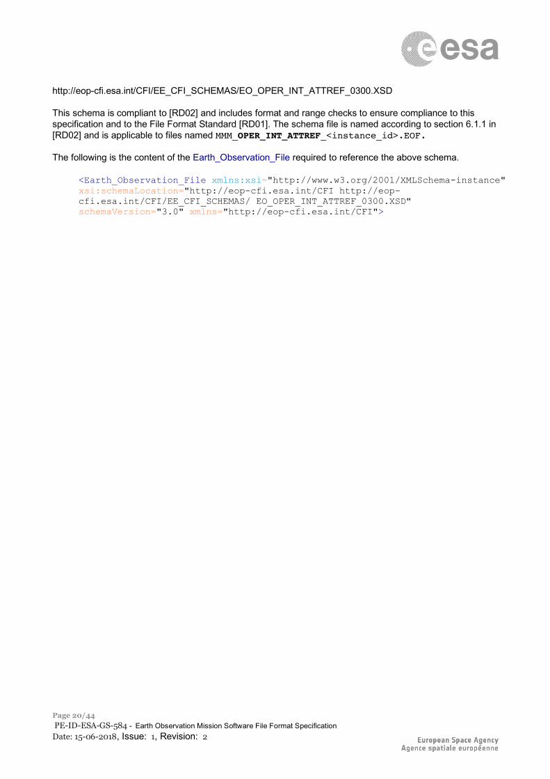
3.1.3 Schema Reference An example of validating XML schema for this file type is located at: http://eop-cfi.esa.int/CFI/EE_CFI_SCHEMAS/EO_OPER_AUX_ORBRES_0300.XSD This schema is compliant to [RD02] and includes format and range checks to ensure compliance to this specification and to the File Format Standard [RD01]. The schema file is named according to section 6.1.1 in [RD02] and is applicable to files named MMM_OPER_AUX_ORBRES_<instance_id>.EOF. The following is the content of the Earth_Observation_File required to reference the above schema.
<Earth_Observation_File xmlns:xsi="http://www.w3.org/2001/XMLSchema-instance" xsi:schemaLocation="http://eop-cfi.esa.int/CFI http://eop-cfi.esa.int/CFI/EE_CFI_SCHEMAS/EO_OPER_AUX_ORBRES_0300.XSD" schemaVersion="3.0" xmlns="http://eop-cfi.esa.int/CFI">
ESA UNCLASSIFIED – Releasable to the Public
Page 11/44 PE-ID-ESA-GS-584 - Earth Observation Mission Software File Format Specification Date: 15-06-2018, Issue: 1, Revision: 2
3.2 Orbit Scenario File
3.2.1 Variable Header The Variable Header content is a sequence of XML elements described in Table 6. XML Tag name Type Attributes C Format Description Time_Reference string - %s Time reference used when, due to an inconsistency with
other time correlations, times associated to the state vector have to be recomputed. It can be one of the following values: UT1
Table 6 – Variable Header content
Example:
<Variable_Header> <Time_Reference>UTC</Time_Reference> </Variable_Header>
3.2.2 Data Block The Data Block content is a sequence of XML elements described in Table 7. XML Tag name Type Attributes C Format Description List_of_Orbit_Changes XML
element count=”N” where n is the number of elements in the list
- List of Orbit_Change elements (see Table 8).
Table 7 – Data Block content
XML Tag name Type Attributes C Format Description Orbit XML
element - - Orbit information (see Table 9).
Cycle XML element
- - Cycle information (see Table 10).
Time_of_ANX XML element
- - Ascending node time (see Table 12).
Table 8 – Orbit_Change element content
XML Tag name Type Attributes C Format Description Absolute_Orbit integer - %ld absolute orbit number Relative_Orbit integer - %ld relative orbit number Cycle_Number integer - %ld cycle number Phase_Number integer - %ld phase number
Table 9 – Orbit element content
ESA UNCLASSIFIED – Releasable to the Public
Page 12/44 PE-ID-ESA-GS-584 - Earth Observation Mission Software File Format Specification Date: 15-06-2018, Issue: 1, Revision: 2
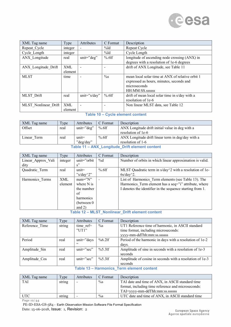
XML Tag name Type Attributes C Format Description Repeat_Cycle integer - %ld Repeat Cycle Cycle_Length integer %ld Cycle Length ANX_Longitude real unit=”deg” %.6lf longitude of ascending node crossing (ANX) in
degrees with a resolution of 1e-6 degrees ANX_Longitude_Drift XML
element - - drift of ANX Longitude, see Table 11
MLST time - %s mean local solar time at ANX of relative orbit 1 expressed as hours, minutes, seconds and microseconds HH:MM:SS.ssssss
MLST_Drift real unit=”s/day” %.6lf drift of mean local solar time in s/day with a resolution of 1e-6
MLST_Nonlinear_Drift XML element
- - Non linear MLST data, see Table 12
Table 10 – Cycle element content
XML Tag name Type Attributes C Format Description Offset real unit=”deg” %.6lf ANX Longitude drift initial value in deg with a
resolution of 1e-6 Linear_Term real unit=
”deg/day” %.6lf ANX Longitude drift linear term in deg/day with a
resolution of 1-6 Table 11 – ANX_Longitude_Drift element content
XML Tag name Type Attributes C Format Description Linear_Approx_Validity
integer unit=”orbits”
%d Number of orbits in which linear approximation is valid.
Quadratic_Term real unit= ”s/day^2”
%.6lf MLST Quadratic term in s/day^2 with a resolution of 1e-6s/day^2.
Harmonics_Terms XML element
num=”N” where N is the number of harmonics (between 0 and 2)
-
List of Harmonics_Term elements (see Table 13). The Harmonics_Term element has a seq=”i” attribute, where I denotes the identifier in the sequence starting from 1.
Table 12 – MLST_Nonlinear_Drift element content
XML Tag name Type Attributes C Format Description Reference_Time string time_ref=
”UT1” %s UT1 Reference time of harmonic, in ASCII standard
time format, including microseconds: yyyy-mm-ddThh:mm:ss.ssssss
Period real unit=”days”
%6.2lf Period of the harmonic in days with a resolution of 1e-2 days.
Amplitude_Sin real unit=”sec” %5.3lf Amplitude of sine in seconds with a resolution of 1e-3 seconds
Amplitude_Cos real unit=”sec” %5.3lf Amplitude of cosine in seconds with a resolution of 1e-3 seconds
Table 13 – Harmonics_Term element content
XML Tag name Type Attributes C Format Description TAI string - %s TAI date and time of ANX, in ASCII standard time
format, including time reference and microseconds: TAI=yyyy-mm-ddThh:mm:ss.ssssss
UTC string - %s UTC date and time of ANX, in ASCII standard time
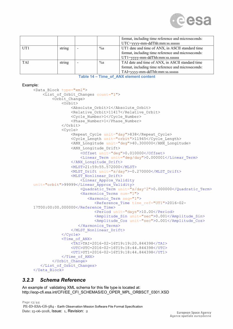
ESA UNCLASSIFIED – Releasable to the Public
Page 13/44 PE-ID-ESA-GS-584 - Earth Observation Mission Software File Format Specification Date: 15-06-2018, Issue: 1, Revision: 2
format, including time reference and microseconds: UTC=yyyy-mm-ddThh:mm:ss.ssssss
UT1 string - %s UT1 date and time of ANX, in ASCII standard time format, including time reference and microseconds: UT1=yyyy-mm-ddThh:mm:ss.ssssss
TAI string - %s TAI date and time of ANX, in ASCII standard time format, including time reference and microseconds: TAI=yyyy-mm-ddThh:mm:ss.ssssss
Table 14 – Time_of_ANX element content
Example: <Data_Block type="xml"> <List_of_Orbit_Changes count="1"> <Orbit_Change> <Orbit> <Absolute_Orbit>1</Absolute_Orbit> <Relative_Orbit>11417</Relative_Orbit> <Cycle_Number>1</Cycle_Number> <Phase_Number>1</Phase_Number> </Orbit> <Cycle> <Repeat_Cycle unit="day">838</Repeat_Cycle> <Cycle_Length unit="orbit">11945</Cycle_Length> <ANX_Longitude unit="deg">40.300000</ANX_Longitude> <ANX_Longitude_Drift> <Offset unit="deg">0.010000</Offset> <Linear_Term unit="deg/day">0.000001</Linear_Term> </ANX_Longitude_Drift> <MLST>21:59:55.572000</MLST> <MLST_Drift unit="s/day">-0.270000</MLST_Drift> <MLST_Nonlinear_Drift> <Linear_Approx_Validity unit="orbit">99999</Linear_Approx_Validity> <Quadratic_Term unit="s/day^2">0.000000</Quadratic_Term> <Harmonics_Terms num="1"> <Harmonic_Term seq="1"> <Reference_Time time_ref="UT1">2016-02-17T00:00:00.000000</Reference_Time> <Period unit="days">10.00</Period> <Amplitude_Sin unit="sec">0.001</Amplitude_Sin> <Amplitude_Cos unit="sec">0.001</Amplitude_Cos> </Harmonics_Terms> </MLST_Nonlinear_Drift> </Cycle> <Time_of_ANX> <TAI>TAI=2016-02-16T19:19:20.844398</TAI> <UTC>UTC=2016-02-16T19:18:44.844398</UTC> <UT1>UT1=2016-02-16T19:18:44.844398</UT1> </Time_of_ANX> </Orbit_Change> </List_of_Orbit_Changes> </Data_Block>
3.2.3 Schema Reference An example of validating XML schema for this file type is located at: http://eop-cfi.esa.int/CFI/EE_CFI_SCHEMAS/EO_OPER_MPL_ORBSCT_0301.XSD
ESA UNCLASSIFIED – Releasable to the Public
Page 14/44 PE-ID-ESA-GS-584 - Earth Observation Mission Software File Format Specification Date: 15-06-2018, Issue: 1, Revision: 2
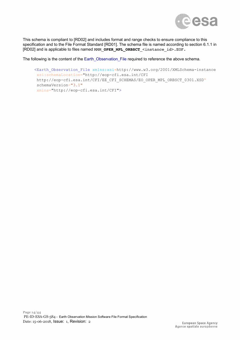
This schema is compliant to [RD02] and includes format and range checks to ensure compliance to this specification and to the File Format Standard [RD01]. The schema file is named according to section 6.1.1 in [RD02] and is applicable to files named MMM_OPER_MPL_ORBSCT_<instance_id>.EOF. The following is the content of the Earth_Observation_File required to reference the above schema.
<Earth_Observation_File xmlns:xsi=http://www.w3.org/2001/XMLSchema-instance xsi:schemaLocation="http://eop-cfi.esa.int/CFI http://eop-cfi.esa.int/CFI/EE_CFI_SCHEMAS/EO_OPER_MPL_ORBSCT_0301.XSD“ schemaVersion="3.1" xmlns="http://eop-cfi.esa.int/CFI">
ESA UNCLASSIFIED – Releasable to the Public
Page 15/44 PE-ID-ESA-GS-584 - Earth Observation Mission Software File Format Specification Date: 15-06-2018, Issue: 1, Revision: 2
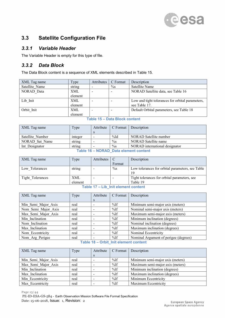
3.3 Satellite Configuration File
3.3.1 Variable Header The Variable Header is empty for this type of file.
3.3.2 Data Block The Data Block content is a sequence of XML elements described in Table 15. XML Tag name Type Attributes C Format Description Satellite_Name string - %s Satellite Name NORAD_Data XML
element - - NORAD Satellite data, see Table 16
Lib_Init XML element
- - Low and tight tolerances for orbital parameters, see Table 17.
Orbit_Init XML element
- - Default Orbital parameters, see Table 18
Table 15 – Data Block content
XML Tag name Type Attributes
C Format Description
Satellite_Number integer - %ld NORAD Satellite number NORAD_Sat_Name string - %s NORAD Satellite name Int_Designator string - %s NORAD international designator
Table 16 – NORAD_Data element content
XML Tag name Type Attributes C Format
Description
Low_Tolerances string - %s Low tolerances for orbital parameters, see Table 19
Tight_Tolerances XML element
- - Tight tolerances for orbital parameters, see Table 19
Table 17 – Lib_Init element content
XML Tag name Type Attributes
C Format Description
Min_Semi_Major_Axis real - %lf Minimum semi-major axis (meters) Nom_Semi_Major_Axis real - %lf Nominal semi-major axis (meters) Max_Semi_Major_Axis real - %lf Maximum semi-major axis (meters) Min_Inclination real - %lf Minimum inclination (degrees) Nom_Inclination real - %lf Nominal inclination (degrees) Max_Inclination real - %lf Maximum inclination (degrees) Nom_Eccentricity real - %lf Nominal Eccentricity Nom_Arg_Perigee real - %lf Nominal Argument of perigee (degrees)
Table 18 – Orbit_Init element content
XML Tag name Type Attributes
C Format Description
Min_Semi_Major_Axis real - %lf Minimum semi-major axis (meters) Max_Semi_Major_Axis real - %lf Maximum semi-major axis (meters) Min_Inclination real - %lf Minimum inclination (degrees) Max_Inclination real - %lf Maximum inclination (degrees) Min_Eccentricity real - %lf Minimum Eccentricity Max_Eccentricity real - %lf Maximum Eccentricity
ESA UNCLASSIFIED – Releasable to the Public
Page 16/44 PE-ID-ESA-GS-584 - Earth Observation Mission Software File Format Specification Date: 15-06-2018, Issue: 1, Revision: 2
Min_Semi_Major_Axis real - %lf Minimum semi-major axis (meters) Max_Semi_Major_Axis real - %lf Maximum semi-major axis (meters)
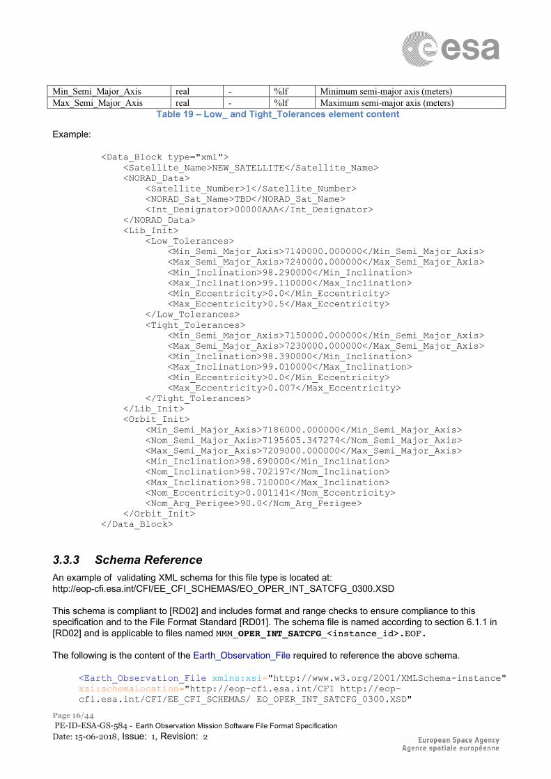
Table 19 – Low_ and Tight_Tolerances element content
Example:
<Data_Block type="xml"> <Satellite_Name>NEW_SATELLITE</Satellite_Name> <NORAD_Data> <Satellite_Number>1</Satellite_Number> <NORAD_Sat_Name>TBD</NORAD_Sat_Name> <Int_Designator>00000AAA</Int_Designator> </NORAD_Data> <Lib_Init> <Low_Tolerances> <Min_Semi_Major_Axis>7140000.000000</Min_Semi_Major_Axis> <Max_Semi_Major_Axis>7240000.000000</Max_Semi_Major_Axis> <Min_Inclination>98.290000</Min_Inclination> <Max_Inclination>99.110000</Max_Inclination> <Min_Eccentricity>0.0</Min_Eccentricity> <Max_Eccentricity>0.5</Max_Eccentricity> </Low_Tolerances> <Tight_Tolerances> <Min_Semi_Major_Axis>7150000.000000</Min_Semi_Major_Axis> <Max_Semi_Major_Axis>7230000.000000</Max_Semi_Major_Axis> <Min_Inclination>98.390000</Min_Inclination> <Max_Inclination>99.010000</Max_Inclination> <Min_Eccentricity>0.0</Min_Eccentricity> <Max_Eccentricity>0.007</Max_Eccentricity> </Tight_Tolerances> </Lib_Init> <Orbit_Init> <Min_Semi_Major_Axis>7186000.000000</Min_Semi_Major_Axis> <Nom_Semi_Major_Axis>7195605.347274</Nom_Semi_Major_Axis> <Max_Semi_Major_Axis>7209000.000000</Max_Semi_Major_Axis> <Min_Inclination>98.690000</Min_Inclination> <Nom_Inclination>98.702197</Nom_Inclination> <Max_Inclination>98.710000</Max_Inclination> <Nom_Eccentricity>0.001141</Nom_Eccentricity> <Nom_Arg_Perigee>90.0</Nom_Arg_Perigee> </Orbit_Init> </Data_Block>
3.3.3 Schema Reference An example of validating XML schema for this file type is located at: http://eop-cfi.esa.int/CFI/EE_CFI_SCHEMAS/EO_OPER_INT_SATCFG_0300.XSD This schema is compliant to [RD02] and includes format and range checks to ensure compliance to this specification and to the File Format Standard [RD01]. The schema file is named according to section 6.1.1 in [RD02] and is applicable to files named MMM_OPER_INT_SATCFG_<instance_id>.EOF. The following is the content of the Earth_Observation_File required to reference the above schema.
<Earth_Observation_File xmlns:xsi="http://www.w3.org/2001/XMLSchema-instance" xsi:schemaLocation="http://eop-cfi.esa.int/CFI http://eop-cfi.esa.int/CFI/EE_CFI_SCHEMAS/ EO_OPER_INT_SATCFG_0300.XSD"
ESA UNCLASSIFIED – Releasable to the Public
Page 17/44 PE-ID-ESA-GS-584 - Earth Observation Mission Software File Format Specification Date: 15-06-2018, Issue: 1, Revision: 2
schemaVersion="3.0" xmlns="http://eop-cfi.esa.int/CFI">
ESA UNCLASSIFIED – Releasable to the Public
Page 18/44 PE-ID-ESA-GS-584 - Earth Observation Mission Software File Format Specification Date: 15-06-2018, Issue: 1, Revision: 2
3.4 Attitude Quaternion File
3.4.1 Variable Header The Variable Header is empty for this type of file.
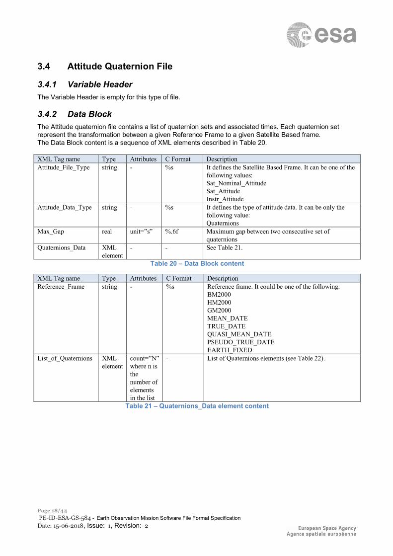
3.4.2 Data Block The Attitude quaternion file contains a list of quaternion sets and associated times. Each quaternion set represent the transformation between a given Reference Frame to a given Satellite Based frame. The Data Block content is a sequence of XML elements described in Table 20. XML Tag name Type Attributes C Format Description Attitude_File_Type string - %s It defines the Satellite Based Frame. It can be one of the
following values: Sat_Nominal_Attitude Sat_Attitude Instr_Attitude
Attitude_Data_Type string - %s It defines the type of attitude data. It can be only the following value: Quaternions
Max_Gap real unit=”s” %.6f Maximum gap between two consecutive set of quaternions
Quaternions_Data XML element
- - See Table 21.
Table 20 – Data Block content
XML Tag name Type Attributes C Format Description Reference_Frame string - %s Reference frame. It could be one of the following:
BM2000 HM2000 GM2000 MEAN_DATE TRUE_DATE QUASI_MEAN_DATE PSEUDO_TRUE_DATE EARTH_FIXED
List_of_Quaternions XML element
count=”N” where n is the number of elements in the list
- List of Quaternions elements (see Table 22).
Table 21 – Quaternions_Data element content
ESA UNCLASSIFIED – Releasable to the Public
Page 19/44 PE-ID-ESA-GS-584 - Earth Observation Mission Software File Format Specification Date: 15-06-2018, Issue: 1, Revision: 2
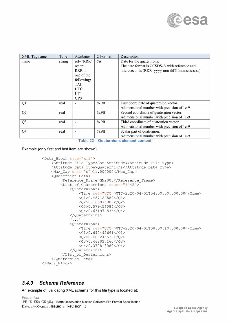
XML Tag name Type Attributes C Format Description Time string ref=”RRR”
where RRR is one of the following: TAI UTC UT1 GPS
%s Date for the quaternions. The date format is CCSDS-A with reference and microseconds (RRR=yyyy-mm-ddThh:nn:ss.ssssss)
Q1 real - %.9lf First coordinate of quaternion vector. Adimensional number with precision of 1e-9
Q2 real - %.9lf Second coordinate of quaternion vector. Adimensional number with precision of 1e-9
Q3 real - %.9lf Third coordinate of quaternion vector. Adimensional number with precision of 1e-9
Q4 real - %.9lf Scalar part of quaternion. Adimensional number with precision of 1e-9
Table 22 – Quaternions element content
Example (only first and last item are shown):
<Data_Block type="xml"> <Attitude_File_Type>Sat_Attitude</Attitude_File_Type> <Attitude_Data_Type>Quaternions</Attitude_Data_Type> <Max_Gap unit="s">11.000000</Max_Gap> <Quaternion_Data> <Reference_Frame>GM2000</Reference_Frame> <List_of_Quaternions count="1442"> <Quaternions> <Time ref="UTC">UTC=2020-04-01T04:00:00.000000</Time> <Q1>0.487124882</Q1> <Q2>0.165975309</Q2> <Q3>0.579456084</Q3> <Q4>0.631974836</Q4> </Quaternions> [...] <Quaternions> <Time ref="UTC">UTC=2020-04-01T08:00:10.000000</Time> <Q1>0.690492661</Q1> <Q2>0.408245532</Q2> <Q3>0.468027160</Q3> <Q4>0.370818080</Q4> </Quaternions> </List_of_Quaternions> </Quaternion_Data> </Data_Block>
3.4.3 Schema Reference An example of validating XML schema for this file type is located at:
ESA UNCLASSIFIED – Releasable to the Public
Page 20/44 PE-ID-ESA-GS-584 - Earth Observation Mission Software File Format Specification Date: 15-06-2018, Issue: 1, Revision: 2
http://eop-cfi.esa.int/CFI/EE_CFI_SCHEMAS/EO_OPER_INT_ATTREF_0300.XSD This schema is compliant to [RD02] and includes format and range checks to ensure compliance to this specification and to the File Format Standard [RD01]. The schema file is named according to section 6.1.1 in [RD02] and is applicable to files named MMM_OPER_INT_ATTREF_<instance_id>.EOF. The following is the content of the Earth_Observation_File required to reference the above schema.
<Earth_Observation_File xmlns:xsi="http://www.w3.org/2001/XMLSchema-instance" xsi:schemaLocation="http://eop-cfi.esa.int/CFI http://eop-cfi.esa.int/CFI/EE_CFI_SCHEMAS/ EO_OPER_INT_ATTREF_0300.XSD" schemaVersion="3.0" xmlns="http://eop-cfi.esa.int/CFI">
ESA UNCLASSIFIED – Releasable to the Public
Page 21/44 PE-ID-ESA-GS-584 - Earth Observation Mission Software File Format Specification Date: 15-06-2018, Issue: 1, Revision: 2
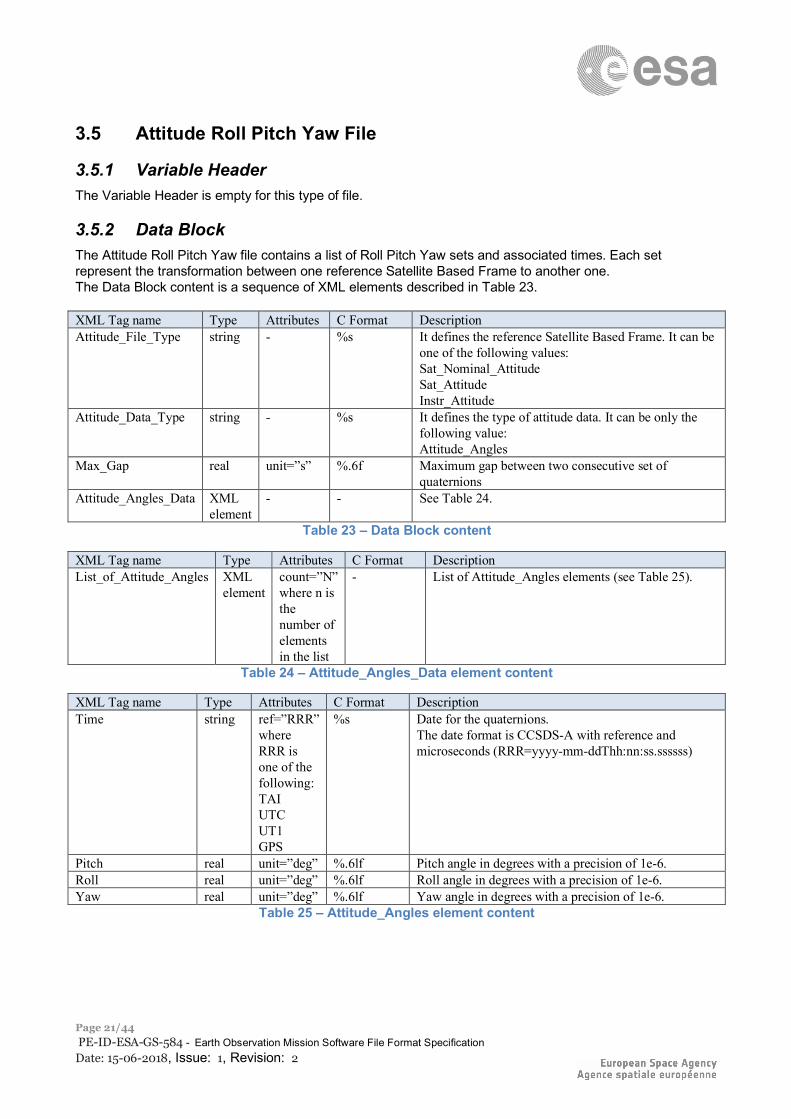
3.5 Attitude Roll Pitch Yaw File
3.5.1 Variable Header The Variable Header is empty for this type of file.
3.5.2 Data Block The Attitude Roll Pitch Yaw file contains a list of Roll Pitch Yaw sets and associated times. Each set represent the transformation between one reference Satellite Based Frame to another one. The Data Block content is a sequence of XML elements described in Table 23. XML Tag name Type Attributes C Format Description Attitude_File_Type string - %s It defines the reference Satellite Based Frame. It can be
one of the following values: Sat_Nominal_Attitude Sat_Attitude Instr_Attitude
Attitude_Data_Type string - %s It defines the type of attitude data. It can be only the following value: Attitude_Angles
Max_Gap real unit=”s” %.6f Maximum gap between two consecutive set of quaternions
Attitude_Angles_Data XML element
- - See Table 24.
Table 23 – Data Block content
XML Tag name Type Attributes C Format Description List_of_Attitude_Angles XML
element count=”N” where n is the number of elements in the list
- List of Attitude_Angles elements (see Table 25).
Table 24 – Attitude_Angles_Data element content
XML Tag name Type Attributes C Format Description Time string ref=”RRR”
where RRR is one of the following: TAI UTC UT1 GPS
%s Date for the quaternions. The date format is CCSDS-A with reference and microseconds (RRR=yyyy-mm-ddThh:nn:ss.ssssss)
Pitch real unit=”deg” %.6lf Pitch angle in degrees with a precision of 1e-6. Roll real unit=”deg” %.6lf Roll angle in degrees with a precision of 1e-6. Yaw real unit=”deg” %.6lf Yaw angle in degrees with a precision of 1e-6.
Table 25 – Attitude_Angles element content
ESA UNCLASSIFIED – Releasable to the Public
Page 22/44 PE-ID-ESA-GS-584 - Earth Observation Mission Software File Format Specification Date: 15-06-2018, Issue: 1, Revision: 2
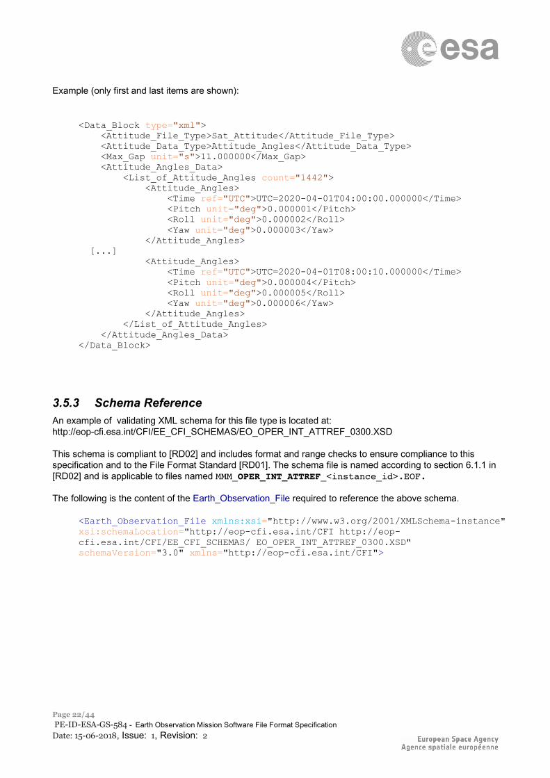
Example (only first and last items are shown):
<Data_Block type="xml"> <Attitude_File_Type>Sat_Attitude</Attitude_File_Type> <Attitude_Data_Type>Attitude_Angles</Attitude_Data_Type> <Max_Gap unit="s">11.000000</Max_Gap> <Attitude_Angles_Data> <List_of_Attitude_Angles count="1442"> <Attitude_Angles> <Time ref="UTC">UTC=2020-04-01T04:00:00.000000</Time> <Pitch unit="deg">0.000001</Pitch> <Roll unit="deg">0.000002</Roll> <Yaw unit="deg">0.000003</Yaw> </Attitude_Angles> [...] <Attitude_Angles> <Time ref="UTC">UTC=2020-04-01T08:00:10.000000</Time> <Pitch unit="deg">0.000004</Pitch> <Roll unit="deg">0.000005</Roll> <Yaw unit="deg">0.000006</Yaw> </Attitude_Angles> </List_of_Attitude_Angles> </Attitude_Angles_Data> </Data_Block>
3.5.3 Schema Reference An example of validating XML schema for this file type is located at: http://eop-cfi.esa.int/CFI/EE_CFI_SCHEMAS/EO_OPER_INT_ATTREF_0300.XSD This schema is compliant to [RD02] and includes format and range checks to ensure compliance to this specification and to the File Format Standard [RD01]. The schema file is named according to section 6.1.1 in [RD02] and is applicable to files named MMM_OPER_INT_ATTREF_<instance_id>.EOF. The following is the content of the Earth_Observation_File required to reference the above schema.
<Earth_Observation_File xmlns:xsi="http://www.w3.org/2001/XMLSchema-instance" xsi:schemaLocation="http://eop-cfi.esa.int/CFI http://eop-cfi.esa.int/CFI/EE_CFI_SCHEMAS/ EO_OPER_INT_ATTREF_0300.XSD" schemaVersion="3.0" xmlns="http://eop-cfi.esa.int/CFI">
ESA UNCLASSIFIED – Releasable to the Public
Page 23/44 PE-ID-ESA-GS-584 - Earth Observation Mission Software File Format Specification Date: 15-06-2018, Issue: 1, Revision: 2
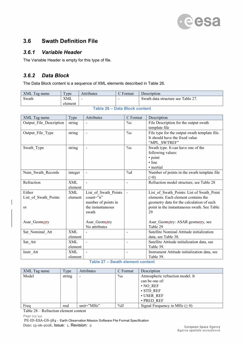
3.6 Swath Definition File
3.6.1 Variable Header The Variable Header is empty for this type of file.
3.6.2 Data Block The Data Block content is a sequence of XML elements described in Table 26. XML Tag name Type Attributes C Format Description Swath XML
element - - Swath data structure see Table 27.
Table 26 – Data Block content
XML Tag name Type Attributes C Format Description Output_File_Description string - %s File Description for the output swath
template file Output_File_Type string - %s File type for the output swath template file.
It should have the fixed value “MPL_SWTREF”
Swath_Type string - %s Swath type. It can have one of the following values: • point • line • inertial
Num_Swath_Records integer - %d Number of points in the swath template file (>0)
Refraction XML element
- - Refraction model structure, see Table 28
Either List_of_Swath_Points or Asar_Geometry
XML element
List_of_Swath_Points count=”n” number of points in the instantaneous swath Asar_Geometry No attributes
- List_of_Swath_Points: List of Swath_Point elements. Each element contains the geometry data for the calculation of each point in the instantaneous swath. See Table 29 Asar_Geometry: ASAR geometry, see Table 29
Sat_Nominal_Att XML element
- - Satellite Nominal Attitude initialization data, see Table 38.
Sat_Att XML element
- - Satellite Attitude initialization data, see Table 39.
Instr_Att XML element
- - Instrument Attitude initialization data, see Table 39.
Table 27 – Swath element content
XML Tag name Type Attributes C Format Description Model string - %s Atmospheric refraction model. It
can be one of: • NO_REF • STD_REF • USER_REF • PRED_REF
Freq real unit=”MHz” %lf Signal Frequency in MHz (≥ 0) Table 28 – Refraction element content
ESA UNCLASSIFIED – Releasable to the Public
Page 24/44 PE-ID-ESA-GS-584 - Earth Observation Mission Software File Format Specification Date: 15-06-2018, Issue: 1, Revision: 2
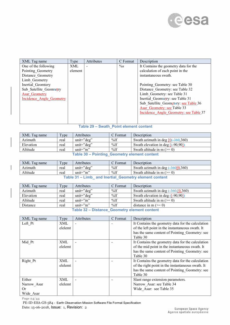
XML Tag name Type Attributes C Format Description One of the following Pointing_Geometry Distance_Geometry Limb_Geometry Inertial_Geomtery Sub_Satellite_Geomtetry Asar_Geometry Incidence_Angle_Geometry
XML element
- %s It Contains the geometry data for the calculation of each point in the instantaneous swath. Pointing_Geometry: see Table 30 Distance_Geometry: see Table 32 Limb_Geometry: see Table 31 Inertial_Geomtetry: see Table 31 Sub_Satellite_Geometery: see Table 36 Asar_Geometry: see Table 33 Incidence_Angle_Geometry: see Table 37
Table 29 – Swath_Point element content
XML Tag name Type Attributes C Format Description Azimuth real unit=”deg” %lf Swath azimuth in deg [0(-360,360) Elevation real unit=”deg” %lf Swath elevation in deg [(-90,90]) Altitude real unit=”m” %lf Swath altitude in m (>= 0)
Table 30 – Pointing_Geometry element content
XML Tag name Type Attributes C Format Description Azimuth real unit=”deg” %lf Swath azimuth in deg (-360[0,360) Altitude real unit=”m” %lf Swath altitude in m (>= 0)
Table 31 – Limb_ and Inertial_Geometry element content
XML Tag name Type Attributes C Format Description Azimuth real unit=”deg” %lf Swath azimuth in deg (-360,[0,360) Elevation real unit=”deg” %lf Swath elevation in deg ([-90,90]) Altitude real unit=”m” %lf Swath altitude in m (>= 0) Distance real unit=”m” %lf distance in m (>= 0)
Table 32 – Distance_Geometry element content
XML Tag name Type Attributes C Format Description Left_Pt XML
elelemt - - It Contains the geometry data for the calculation
of the left point in the instantaneous swath. It has the same content of Pointing_Geometry: see Table 30
Mid_Pt XML elelemt
- - It Contains the geometry data for the calculation of the mid point in the instantaneous swath. It has the same content of Pointing_Geometry: see Table 30
Right_Pt XML elelemt
- - It Contains the geometry data for the calculation of the right point in the instantaneous swath. It has the same content of Pointing_Geometry: see Table 30
Either Narrow_Asar Or Wide_Asar
XML elelemt
- - Slant range extension parameters. Narrow_Asar: see Table 34 Wide_Asar: see Table 35
ESA UNCLASSIFIED – Releasable to the Public
Page 25/44 PE-ID-ESA-GS-584 - Earth Observation Mission Software File Format Specification Date: 15-06-2018, Issue: 1, Revision: 2
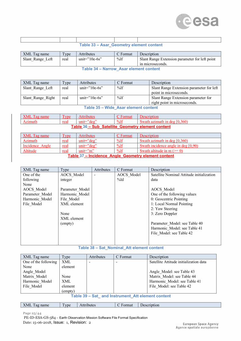
Table 33 – Asar_Geometry element content
XML Tag name Type Attributes C Format Description Slant_Range_Left real unit=”10e-6s” %lf Slant Range Extension parameter for left point
in microseconds. Table 34 – Narrow_Asar element content
XML Tag name Type Attributes C Format Description Slant_Range_Left real unit=”10e-6s” %lf Slant Range Extension parameter for left
point in microseconds. Slant_Range_Right real unit=”10e-6s” %lf Slant Range Extension parameter for
right point in microseconds. Table 35 – Wide_Asar element content
XML Tag name Type Attributes C Format Description Azimuth real unit=”deg” %lf Swath azimuth in deg [0,360)
Table 36 – Sub_Satellite_Geometry element content
XML Tag name Type Attributes C Format Description Azimuth real unit=”deg” %lf Swath azimuth in deg [0,360) Incidence_Angle real unit=”deg” %lf Swath incidence angle in deg [0,90) Altitude real unit=”m” %lf Swath altitude in m (>= 0)
Table 37 – Incidence_Angle_Geometry element content
XML Tag name Type Attributes C Format Description One of the following None AOCS_Model Parameter_Model Harmonic_Model File_Model
AOCS_Model integer Parameter_Model Harmonic_Model File_Model XML element None XML element (empty)
- AOCS_Model %ld
Satellite Nominal Attitude initialization data AOCS_Model One of the following values 0: Geocentric Pointing 1: Local Normal Pointing 2: Yaw Steering 3: Zero Doppler Parameter_Model: see Table 40 Harmonic_Model: see Table 41 File_Model: see Table 42
Table 38 – Sat_Nominal_Att element content
XML Tag name Type Attributes C Format Description One of the following None Angle_Model Matrix_Model Harmonic_Model File_Model
XML element None XML element (empty)
- -
Satellite Attitude initialization data Angle_Model: see Table 43 Matrix_Model: see Table 44 Harmonic_Model: see Table 41 File_Model: see Table 42
Table 39 – Sat_ and Instrument_Att element content
XML Tag name Type Attributes C Format Description
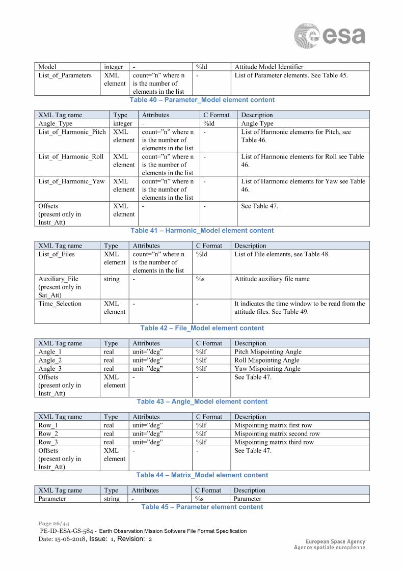
ESA UNCLASSIFIED – Releasable to the Public
Page 26/44 PE-ID-ESA-GS-584 - Earth Observation Mission Software File Format Specification Date: 15-06-2018, Issue: 1, Revision: 2
Model integer - %ld Attitude Model Identifier List_of_Parameters XML
element count=”n” where n is the number of elements in the list
- List of Parameter elements. See Table 45.
Table 40 – Parameter_Model element content
XML Tag name Type Attributes C Format Description Angle_Type integer - %ld Angle Type List_of_Harmonic_Pitch XML
element count=”n” where n is the number of elements in the list
- List of Harmonic elements for Pitch, see Table 46.
List_of_Harmonic_Roll XML element
count=”n” where n is the number of elements in the list
- List of Harmonic elements for Roll see Table 46.
List_of_Harmonic_Yaw XML element
count=”n” where n is the number of elements in the list
- List of Harmonic elements for Yaw see Table 46.
Offsets (present only in Instr_Att)
XML element
- - See Table 47.
Table 41 – Harmonic_Model element content
XML Tag name Type Attributes C Format Description List_of_Files XML
element count=”n” where n is the number of elements in the list
%ld List of File elements, see Table 48.
Auxiliary_File (present only in Sat_Att)
string - %s Attitude auxiliary file name
Time_Selection XML element
- - It indicates the time window to be read from the attitude files. See Table 49.
Table 42 – File_Model element content
XML Tag name Type Attributes C Format Description Angle_1 real unit=”deg” %lf Pitch Mispointing Angle Angle_2 real unit=”deg” %lf Roll Mispointing Angle Angle_3 real unit=”deg” %lf Yaw Mispointing Angle Offsets (present only in Instr_Att)
XML element
- - See Table 47.
Table 43 – Angle_Model element content
XML Tag name Type Attributes C Format Description Row_1 real unit=”deg” %lf Mispointing matrix first row Row_2 real unit=”deg” %lf Mispointing matrix second row Row_3 real unit=”deg” %lf Mispointing matrix third row Offsets (present only in Instr_Att)
XML element
- - See Table 47.
Table 44 – Matrix_Model element content
XML Tag name Type Attributes C Format Description Parameter string - %s Parameter
Table 45 – Parameter element content
ESA UNCLASSIFIED – Releasable to the Public
Page 27/44 PE-ID-ESA-GS-584 - Earth Observation Mission Software File Format Specification Date: 15-06-2018, Issue: 1, Revision: 2
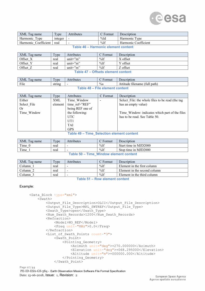
XML Tag name Type Attributes C Format Description Harmonic_Type integer - %ld Harmonic Type Harmonic_Coefficient real - %lf Harmonic Coefficient
Table 46 – Harmonic element content
XML Tag name Type Attributes C Format Description Offset_X real unit=”m” %lf X offset Offset_Y real unit=”m” %lf Y offset Offset_Z real unit=”m” %lf Z offset
Table 47 – Offsets element content
XML Tag name Type Attributes C Format Description File string - %s Attitude filename (full path)
Table 48 – File element content
XML Tag name Type Attributes C Format Description Either Select_File Or Time_Window
XML element
Time_Window time_ref=”REF” being REF one of the following: UTC UT1 TAI GPS
- Select_File: the whole files to be read (the tag has an empty value) Time_Window: indicates which part of the files has to be read. See Table 50.
Table 49 – Time_Selection element content
XML Tag name Type Attributes C Format Description Time_0 real - %lf Start time in MJD2000 Time_1 real - %lf Stop time in MJD2000
Table 50 – Time_Window element content
XML Tag name Type Attributes C Format Description Column_1 real - %lf Element in the first column Column_2 real - %lf Element in the second column Column_3 real - %lf Element in the third column
Table 51 – Row element content
Example:
<Data_Block type="xml"> <Swath> <Output_File_Description>OLCI</Output_File_Description> <Output_File_Type>MPL_SWTREF</Output_File_Type> <Swath_Type>open</Swath_Type> <Num_Swath_Records>1200</Num_Swath_Records> <Refraction> <Model>NO_REF</Model> <Freq unit="MHz">0.0</Freq> </Refraction> <List_of_Swath_Points count="3"> <Swath_Point> <Pointing_Geometry> <Azimuth unit="deg">+270.000000</Azimuth> <Elevation unit="deg">+068.295000</Elevation> <Altitude unit="m">+000000.000</Altitude> </Pointing_Geometry> </Swath_Point>

ESA UNCLASSIFIED – Releasable to the Public
Page 28/44 PE-ID-ESA-GS-584 - Earth Observation Mission Software File Format Specification Date: 15-06-2018, Issue: 1, Revision: 2
<Swath_Point> <Pointing_Geometry> <Azimuth unit="deg">+090.000000</Azimuth> <Elevation unit="deg">+090.000000</Elevation> <Altitude unit="m">+000000.000</Altitude> </Pointing_Geometry> </Swath_Point> <Swath_Point> <Pointing_Geometry> <Azimuth unit="deg">+090.000000</Azimuth> <Elevation unit="deg">+043.135000</Elevation> <Altitude unit="m">+000000.000</Altitude> </Pointing_Geometry> </Swath_Point> </List_of_Swath_Points> <Sat_Nominal_Att> <AOCS_Model>2</AOCS_Model> </Sat_Nominal_Att> <Sat_Att> <None></None> </Sat_Att> <Instr_Att> <None></None> </Instr_Att> </Swath> </Data_Block>
3.6.3 Schema Reference An example of validating XML schema for this file type is located at: http://eop-cfi.esa.int/CFI/EE_CFI_SCHEMAS/EO_OPER_MPL_SW_DEF_0400.XSD This schema is compliant to [RD02] and includes format and range checks to ensure compliance to this specification and to the File Format Standard [RD01]. The schema file is named according to section 6.1.1 in [RD02] and is applicable to files named MMM_OPER_MPL_SW_DEF_<instance_id>.EOF. The following is the content of the Earth_Observation_File required to reference the above schema.
<Earth_Observation_File xmlns:xsi="http://www.w3.org/2001/XMLSchema-instance" xsi:schemaLocation="http://eop-cfi.esa.int/CFI http://eop-cfi.esa.int/CFI/EE_CFI_SCHEMAS/EO_OPER_MPL_SW_DEF_04010.XSD" xmlns="http://eop-cfi.esa.int/CFI" schemaVersion="4.1">
ESA UNCLASSIFIED – Releasable to the Public
Page 29/44 PE-ID-ESA-GS-584 - Earth Observation Mission Software File Format Specification Date: 15-06-2018, Issue: 1, Revision: 2
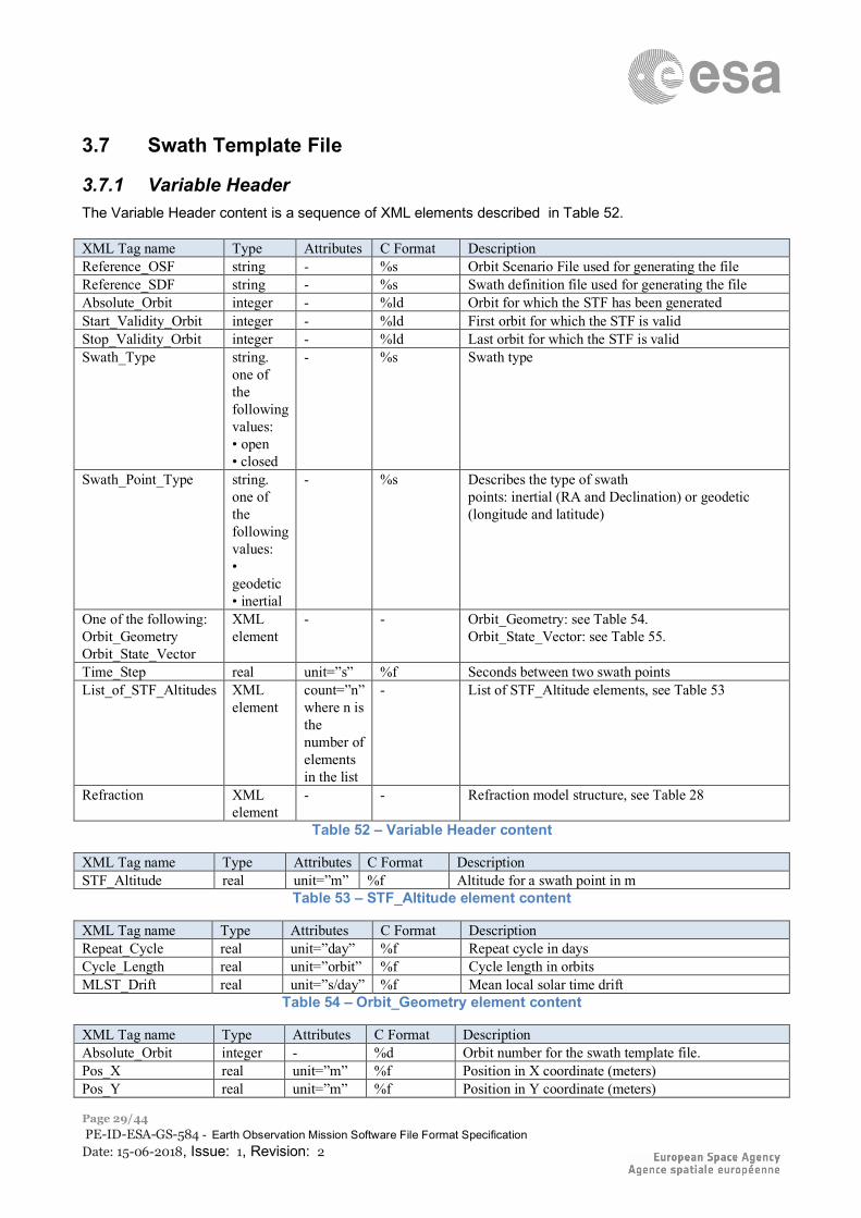
3.7 Swath Template File
3.7.1 Variable Header The Variable Header content is a sequence of XML elements described in Table 52. XML Tag name Type Attributes C Format Description Reference_OSF string - %s Orbit Scenario File used for generating the file Reference_SDF string - %s Swath definition file used for generating the file Absolute_Orbit integer - %ld Orbit for which the STF has been generated Start_Validity_Orbit integer - %ld First orbit for which the STF is valid Stop_Validity_Orbit integer - %ld Last orbit for which the STF is valid Swath_Type string.
one of the following values: • open • closed
- %s Swath type
Swath_Point_Type string. one of the following values: • geodetic • inertial
- %s Describes the type of swath points: inertial (RA and Declination) or geodetic (longitude and latitude)
One of the following: Orbit_Geometry Orbit_State_Vector
XML element
- - Orbit_Geometry: see Table 54. Orbit_State_Vector: see Table 55.
Time_Step real unit=”s” %f Seconds between two swath points List_of_STF_Altitudes XML
element count=”n” where n is the number of elements in the list
- List of STF_Altitude elements, see Table 53
Refraction XML element
- - Refraction model structure, see Table 28
Table 52 – Variable Header content
XML Tag name Type Attributes C Format Description STF_Altitude real unit=”m” %f Altitude for a swath point in m
Table 53 – STF_Altitude element content
XML Tag name Type Attributes C Format Description Repeat_Cycle real unit=”day” %f Repeat cycle in days Cycle_Length real unit=”orbit” %f Cycle length in orbits MLST_Drift real unit=”s/day” %f Mean local solar time drift
Table 54 – Orbit_Geometry element content
XML Tag name Type Attributes C Format Description Absolute_Orbit integer - %d Orbit number for the swath template file. Pos_X real unit=”m” %f Position in X coordinate (meters) Pos_Y real unit=”m” %f Position in Y coordinate (meters)
ESA UNCLASSIFIED – Releasable to the Public
Page 30/44 PE-ID-ESA-GS-584 - Earth Observation Mission Software File Format Specification Date: 15-06-2018, Issue: 1, Revision: 2
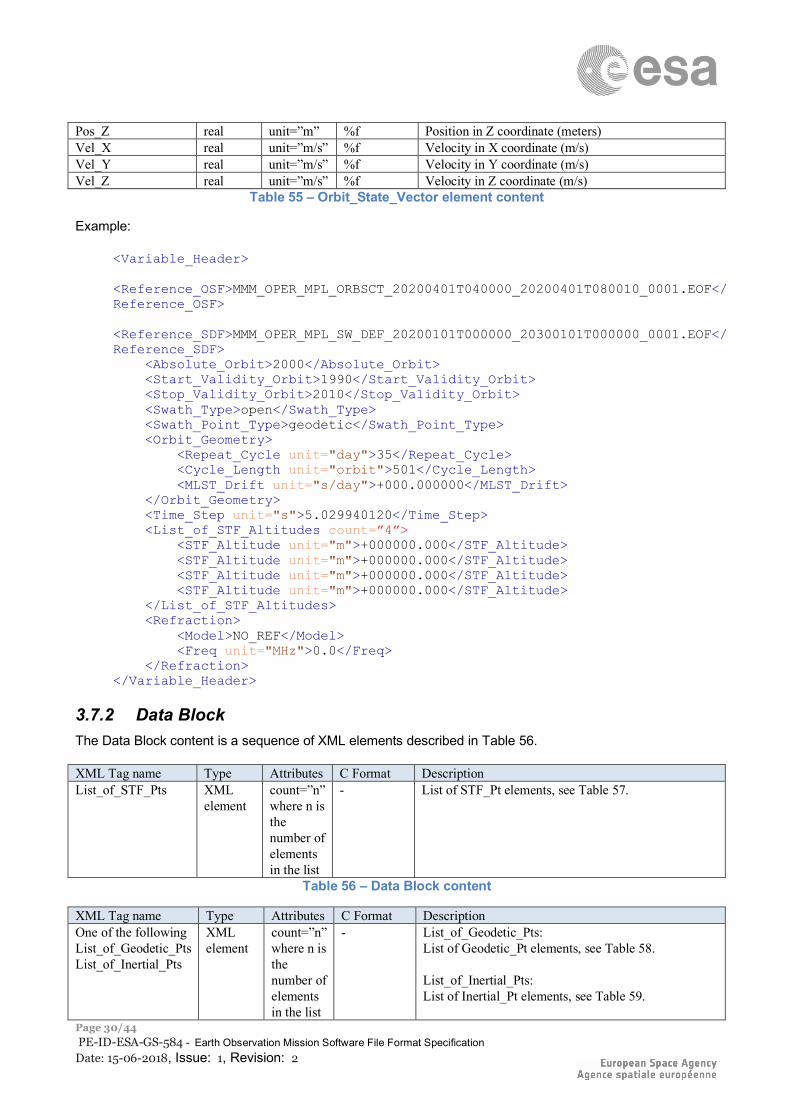
Pos_Z real unit=”m” %f Position in Z coordinate (meters) Vel_X real unit=”m/s” %f Velocity in X coordinate (m/s) Vel_Y real unit=”m/s” %f Velocity in Y coordinate (m/s) Vel_Z real unit=”m/s” %f Velocity in Z coordinate (m/s)
Table 55 – Orbit_State_Vector element content
Example:
<Variable_Header> <Reference_OSF>MMM_OPER_MPL_ORBSCT_20200401T040000_20200401T080010_0001.EOF</Reference_OSF> <Reference_SDF>MMM_OPER_MPL_SW_DEF_20200101T000000_20300101T000000_0001.EOF</Reference_SDF> <Absolute_Orbit>2000</Absolute_Orbit> <Start_Validity_Orbit>1990</Start_Validity_Orbit> <Stop_Validity_Orbit>2010</Stop_Validity_Orbit> <Swath_Type>open</Swath_Type> <Swath_Point_Type>geodetic</Swath_Point_Type> <Orbit_Geometry> <Repeat_Cycle unit="day">35</Repeat_Cycle> <Cycle_Length unit="orbit">501</Cycle_Length> <MLST_Drift unit="s/day">+000.000000</MLST_Drift> </Orbit_Geometry> <Time_Step unit="s">5.029940120</Time_Step> <List_of_STF_Altitudes count=”4”> <STF_Altitude unit="m">+000000.000</STF_Altitude> <STF_Altitude unit="m">+000000.000</STF_Altitude> <STF_Altitude unit="m">+000000.000</STF_Altitude> <STF_Altitude unit="m">+000000.000</STF_Altitude> </List_of_STF_Altitudes> <Refraction> <Model>NO_REF</Model> <Freq unit="MHz">0.0</Freq> </Refraction> </Variable_Header>
3.7.2 Data Block The Data Block content is a sequence of XML elements described in Table 56. XML Tag name Type Attributes C Format Description List_of_STF_Pts XML
element count=”n” where n is the number of elements in the list
- List of STF_Pt elements, see Table 57.
Table 56 – Data Block content
XML Tag name Type Attributes C Format Description One of the following List_of_Geodetic_Pts List_of_Inertial_Pts
XML element
count=”n” where n is the number of elements in the list
- List_of_Geodetic_Pts: List of Geodetic_Pt elements, see Table 58. List_of_Inertial_Pts: List of Inertial_Pt elements, see Table 59.
ESA UNCLASSIFIED – Releasable to the Public
Page 31/44 PE-ID-ESA-GS-584 - Earth Observation Mission Software File Format Specification Date: 15-06-2018, Issue: 1, Revision: 2
Table 57 – STF_Pt element content
XML Tag name Type Attributes C Format Description Long real unit=”deg” %f Longitude of the point in deg Lat real unit=”deg” %f Latitude of the point in deg
Table 58 – Geodetic_Pt element content
XML Tag name Type Attributes C Format Description Ra real unit=”deg” %f Right Ascension in deg Dec real unit=”deg” %f Declination in deg
Table 59 – Inertial_Pt element content
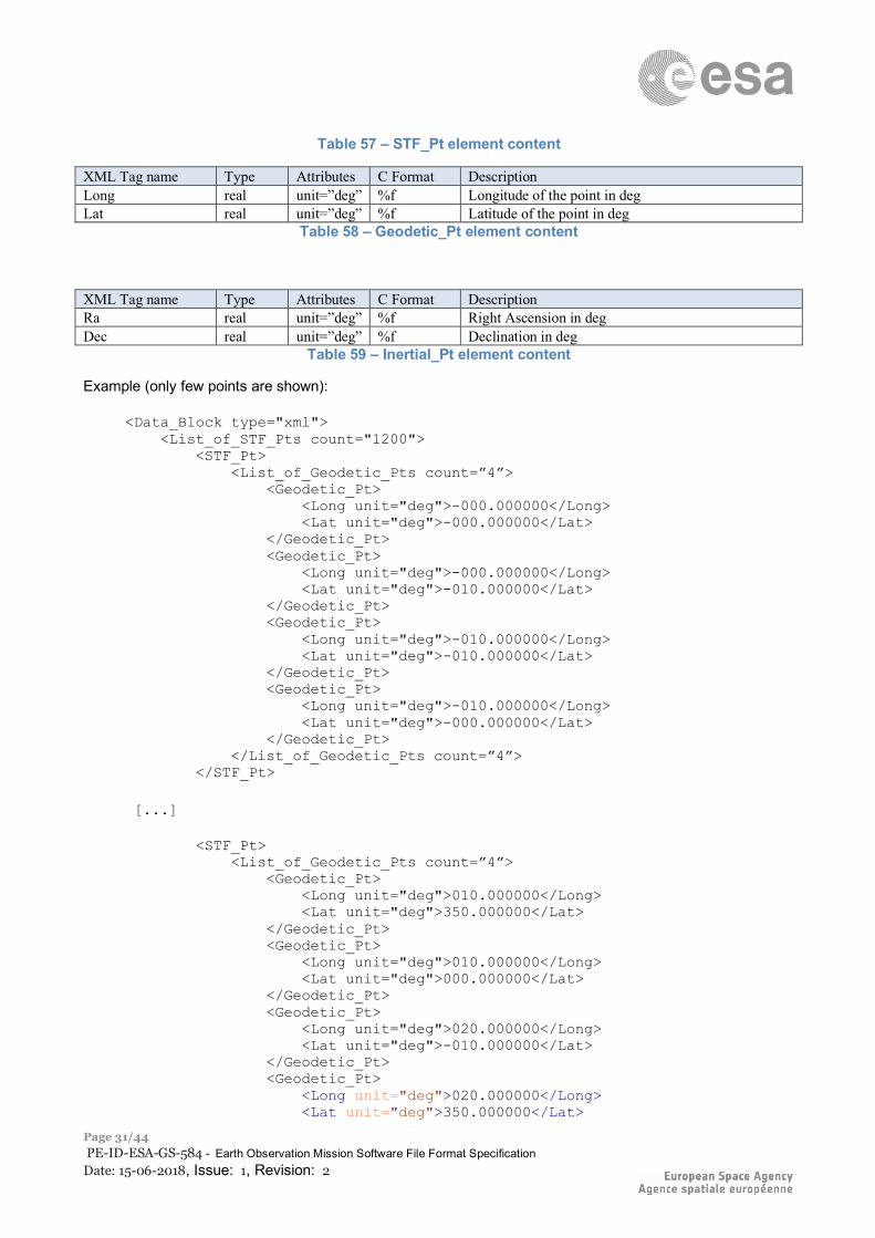
Example (only few points are shown):
<Data_Block type="xml"> <List_of_STF_Pts count="1200"> <STF_Pt> <List_of_Geodetic_Pts count=”4”> <Geodetic_Pt> <Long unit="deg">-000.000000</Long> <Lat unit="deg">-000.000000</Lat> </Geodetic_Pt> <Geodetic_Pt> <Long unit="deg">-000.000000</Long> <Lat unit="deg">-010.000000</Lat> </Geodetic_Pt> <Geodetic_Pt> <Long unit="deg">-010.000000</Long> <Lat unit="deg">-010.000000</Lat> </Geodetic_Pt> <Geodetic_Pt> <Long unit="deg">-010.000000</Long> <Lat unit="deg">-000.000000</Lat> </Geodetic_Pt> </List_of_Geodetic_Pts count=”4”> </STF_Pt> [...] <STF_Pt> <List_of_Geodetic_Pts count=”4”> <Geodetic_Pt> <Long unit="deg">010.000000</Long> <Lat unit="deg">350.000000</Lat> </Geodetic_Pt> <Geodetic_Pt> <Long unit="deg">010.000000</Long> <Lat unit="deg">000.000000</Lat> </Geodetic_Pt> <Geodetic_Pt> <Long unit="deg">020.000000</Long> <Lat unit="deg">-010.000000</Lat> </Geodetic_Pt> <Geodetic_Pt> <Long unit="deg">020.000000</Long> <Lat unit="deg">350.000000</Lat>
ESA UNCLASSIFIED – Releasable to the Public
Page 32/44 PE-ID-ESA-GS-584 - Earth Observation Mission Software File Format Specification Date: 15-06-2018, Issue: 1, Revision: 2
</Geodetic_Pt> </List_of_Geodetic_Pts> </STF_Pt> </List_of_STF_Pts> </Data_Block>
3.7.3 Schema Reference An example of validating XML schema for this file type is located at: http://eop-cfi.esa.int/CFI/EE_CFI_SCHEMAS/EO_OPER_MPL_SWTREF_0400.XSD This schema is compliant to [RD02] and includes format and range checks to ensure compliance to this specification and to the File Format Standard [RD01]. The schema file is named according to section 6.1.1 in [RD02] and is applicable to files named MMM_OPER_MPL_SWTREF_<instance_id>.EOF. The following is the content of the Earth_Observation_File required to reference the above schema.
<Earth_Observation_File xmlns:xsi="http://www.w3.org/2001/XMLSchema-instance" xsi:schemaLocation="http://eop-cfi.esa.int/CFI http://eop-cfi.esa.int/CFI/EE_CFI_SCHEMAS/EO_OPER_MPL_SWTREF_0400.XSD" xmlns="http://eop-cfi.esa.int/CFI" schemaVersion="4.0">
ESA UNCLASSIFIED – Releasable to the Public
Page 33/44 PE-ID-ESA-GS-584 - Earth Observation Mission Software File Format Specification Date: 15-06-2018, Issue: 1, Revision: 2
3.8 Zone Database File
3.8.1 Variable Header The Variable Header is empty for this type of file.
3.8.2 Data Block The Data Block content is a sequence of XML elements described in Table 60. XML Tag name Type Attributes C Format Description List_of_Zones XML
element
count=”n” where n is the number of elements in the list
- List of Zone elements. See Table 61
Table 60 – Data Block content
XML Tag name Type Attributes C Format Description Zone_Id string - %s Zone name Zone_Description string - %s Zone description Surface string - %s Type of surface Projection string - %s Projection Creator string - %s Cretator name List_of_Polygon_Pts XML
element
count=”n” where n is the number of ele- ments in the list
- List of Polygon_Pt elements, points defining the zone. See Table 62.
Diameter real unit=”m” %f Diameter of the zone if the list of polygon points is empty.
Table 61 – Zone element content
XML Tag name Type Attributes C Format Description Long real unit=”deg” %f longitude of the point in deg (-360, 360) Lat real unit=”deg” %f latitude of the point in deg (-90, 90)
Table 62 – Polygon_Pt element content
ESA UNCLASSIFIED – Releasable to the Public
Page 34/44 PE-ID-ESA-GS-584 - Earth Observation Mission Software File Format Specification Date: 15-06-2018, Issue: 1, Revision: 2
Example:
<Data_Block type="xml"> <List_of_Zones count="1"> <Zone> <Zone_Id>RECT_ZONE</Zone_Id> <Zone_Description></Zone_Description> <Surface></Surface> <Projection>RECTANGULAR</Projection> <Creator>TEST DATA</Creator> <List_of_Polygon_Pts count="4"> <Polygon_Pt> <Long unit="deg">-030.000000</Long> <Lat unit="deg">-020.000000</Lat> </Polygon_Pt> <Polygon_Pt> <Long unit="deg">-030.000000</Long> <Lat unit="deg">-010.000000</Lat> </Polygon_Pt> <Polygon_Pt> <Long unit="deg">-011.000000</Long> <Lat unit="deg">-010.000000</Lat> </Polygon_Pt> <Polygon_Pt> <Long unit="deg">-011.000000</Long> <Lat unit="deg">-020.000000</Lat> </Polygon_Pt> </List_of_Polygon_Pts> <Diameter unit="m">+000.000000</Diameter> </Zone> </List_of_Zones> </Data_Block>
3.8.3 Schema Reference An example of validating XML schema for this file type is located at: http://eop-cfi.esa.int/CFI/EE_CFI_SCHEMAS/EO_OPER_MPL_ZON_DB_0300.XSD This schema is compliant to [RD02] and includes format and range checks to ensure compliance to this specification and to the File Format Standard [RD01]. The schema file is named according to section 6.1.1 in [RD02] and is applicable to files named MMM_OPER_MPL_ZON_DB_<instance_id>.EOF. The following is the content of the Earth_Observation_File required to reference the above schema.
<Earth_Observation_File xmlns:xsi="http://www.w3.org/2001/XMLSchema-instance" xsi:schemaLocation="http://eop-cfi.esa.int/CFI http://eop-cfi.esa.int/CFI/EE_CFI_SCHEMAS/EO_OPER_MPL_ZON_DB_0300.XSD" xmlns="http://eop-cfi.esa.int/CFI" schemaVersion="3.0">
ESA UNCLASSIFIED – Releasable to the Public
Page 35/44 PE-ID-ESA-GS-584 - Earth Observation Mission Software File Format Specification Date: 15-06-2018, Issue: 1, Revision: 2
3.9 Station Database File
3.9.1 Variable Header The Variable Header is empty for this type of file.
3.9.2 Data Block The Data Block content is a sequence of XML elements described in Table 63. XML Tag name Type Attributes C Format Description List_of_Ground_Stations
XML element
count=”n” where n is the number of elements in the list
- List of Ground_Station elements. See Table 61
Table 63 – Data Block content
XML Tag name Type Attributes C Format Description Station_Id string - %s Station name Descriptor string - %s Station description Antenna string - %s Antenna band Frequency (optional) real unit=”Hz” %f Frequency in Hz Purpose string - %s Purpose Type string - %s Station Type Location XML
element - - Station location. See Location element, Table
65.
List_of_Spacecrafts XML element
count=”n” where n is the number of elements in the list
Spacecraft dependant mask type parameters. List of Spacecraft elements, see Table 66.
Default_El real unit=”deg” %f Default elevation in deg. List_of_Mask_Points XML
element count=”n” where n is the number of elements in the list
- List of Mask_Point elements, see Table 67.
Table 64 – Ground_Station element content
XML Tag name Type Attributes C Format Description Long real unit=”deg” %f Longitude in deg Lat real unit=”deg” %f Latitude in deg Alt real unit=”deg” %f Altitude in deg
Table 65 – Location element content
XML Tag name Type Attributes C Format Description Name string - %s Spacecraft name Aos_El real unit=”deg” %f Acquisition of signal elevation Los_El real unit=”deg” %f Loss of signal elevation Mask string - %s Mask type. Possible values:
AOS_LOS_WITH_MASK AOS_LOS MASK_ONLY
Table 66 – Spacecraft element content
XML Tag name Type Attributes C Format Description
ESA UNCLASSIFIED – Releasable to the Public
Page 36/44 PE-ID-ESA-GS-584 - Earth Observation Mission Software File Format Specification Date: 15-06-2018, Issue: 1, Revision: 2
Az real unit=”deg” %f Azimuth El real unit=”deg” %f Elevation
Table 67 – Mask_Point element content
Example (only few Mask Points are shown):
<Data_Block type="xml"> <List_of_Ground_Stations count="1"> <Ground_Station> <Station_id>GSVLBRHX</Station_id> <Descriptor>Svalbard (PLATABERGET)</Descriptor> <Antenna>X-BAND </Antenna> <Purpose>GLOBAL + REGIONAL </Purpose> <Type> </Type> <Location> <Long unit="deg">+015.400000</Long> <Lat unit="deg">+078.130000</Lat> <Alt unit="m">+0470.000</Alt> </Location> <List_of_Spacecrafts count="1"> <Spacecraft> <Name>SMOS</Name> <Aos_El unit="deg">+005.000000</Aos_El> <Los_El unit="deg">+005.000000</Los_El> <Mask>AOS_LOS_WITH_MASK</Mask> </Spacecraft> </List_of_Spacecrafts> <Default_El unit="deg">+0000.000</Default_El> <List_of_Mask_Points count="22"> <Mask_Point> <Az unit="deg">+000.000000</Az> <El unit="deg">+000.400000</El> </Mask_Point> <Mask_Point> <Az unit="deg">+032.000000</Az> <El unit="deg">+000.400000</El> </Mask_Point> [...] <Mask_Point> <Az unit="deg">+272.000000</Az> <El unit="deg">+000.400000</El> </Mask_Point> <Mask_Point> <Az unit="deg">+360.000000</Az> <El unit="deg">+000.400000</El> </Mask_Point> </List_of_Mask_Points> </Ground_Station> > </List_of_Ground_Stations> </Data_Block>
ESA UNCLASSIFIED – Releasable to the Public
Page 37/44 PE-ID-ESA-GS-584 - Earth Observation Mission Software File Format Specification Date: 15-06-2018, Issue: 1, Revision: 2
3.9.3 Schema Reference An example of validating XML schema for this file type is located at: http://eop-cfi.esa.int/CFI/EE_CFI_SCHEMAS/EO_OPER_MPL_GND_DB_0300.XSD This schema is compliant to [RD02] and includes format and range checks to ensure compliance to this specification and to the File Format Standard [RD01]. The schema file is named according to section 6.1.1 in [RD02] and is applicable to files named MMM_OPER_MPL_GND_DB_<instance_id>.EOF. The following is the content of the Earth_Observation_File required to reference the above schema.
<Earth_Observation_File xmlns:xsi="http://www.w3.org/2001/XMLSchema-instance" xsi:schemaLocation="http://eop-cfi.esa.int/CFI http://eop-cfi.esa.int/CFI/EE_CFI_SCHEMAS/EO_OPER_MPL_GND_DB_0300.XSD" xmlns="http://eop-cfi.esa.int/CFI" schemaVersion="3.0">
ESA UNCLASSIFIED – Releasable to the Public
Page 38/44 PE-ID-ESA-GS-584 - Earth Observation Mission Software File Format Specification Date: 15-06-2018, Issue: 1, Revision: 2
3.10 Attitude Definition File
3.10.1 Variable Header The Variable Header is empty for this type of file.
3.10.2 Data Block The Data Block content is a sequence of XML elements described in Table 68. XML Tag name Type Attributes C Format Description Attitude_Definition XML
element
- - Attitude_Definition data structure see
Table 68 – Data Block content
XML Tag name Type Attributes C Format Description Sat_Nominal_Att XML
element - - Satellite Nominal Attitude initialization data, see
Table 70 Sat_Att XML
element - - Satellite Attitude initialization data, see Table 71.
Instr_Att XML
element - - Instrument Attitude initialization data, see Table
71. Table 69 – Swath element content
XML Tag name Type Attributes
C Format Description
One of the following: None AOCS_Model Parameter_Model Harmonic_Model File_Model
AOCS_Model integer Parameter_Model Harmonic_Model File_Model XML element None XML element (empty)
- AOCS_Model %ld
Satellite Nominal Attitude initialization data AOCS_Model AOCS model. It can contain the name of the AOCS model or the corresponding number, both are allowed. The allowed values are the following (the equivalent number is shown between parenthesis): GEOCENTRIC_POINTING (0) LOCAL_NORMAL_POINTING (1) YAW_STEERING_MODE (2) ZERO_DOPPLER_YSM (3) Parameter_Model: see Table 40 Harmonic_Model: see Table 41 File_Model: see Table 42
Table 70 – Sat_Nominal_Att element content
XML Tag name Type Attributes C Format Description One of the following None Angle_Model Matrix_Model Harmonic_Model File_Model
XML element None XML element
- -
Satellite Attitude initialization data Angle_Model: see Table 43 Matrix_Model: see Table 44 Harmonic_Model: see Table 41 File_Model: see Table 42
ESA UNCLASSIFIED – Releasable to the Public
Page 39/44 PE-ID-ESA-GS-584 - Earth Observation Mission Software File Format Specification Date: 15-06-2018, Issue: 1, Revision: 2
Only in Sat_Att Quaternion_Plus_Angle Quaternion_Plus_Matrix
(empty)
Quaternion_Plus_Angle Quaternion_Plus_Matrix
Table 71 – Sat_ and Instrument_Att element content
XML Tag name Type Attributes C Format Description Model integer - %ld Attitude Model Identifier
It can contain the name of the model or the corresponding number, both are allowed. The allowed values are the following (the equivalent number is shown between parenthesis): GENERIC (0) ENVISAT (1) CRYOSAT (2) ADM (3) SENTINEL1 (4) SENTINEL2 (5) GEO (6) METOPSG (7)
List_of_Parameters XML element
count=”n” where n is the number of elements in the list
- List of Parameter elements. See Table 45.
Table 72 – Parameter_Model element content
XML Tag name Type Attributes C Format Description Angle_Type integer - %ld It can contain the name of the angle type or
the corresponding number, both are allowed. The allowed values are the following (the equivalent number is shown between parenthesis): TRUE_LAT_TOD (0) MEAN_LAT_TOD (1)
List_of_Harmonic_Pitch XML element
count=”n” where n is the number of elements in the list
- List of Harmonic elements for Pitch see Table 46.
List_of_Harmonic_Roll XML element
count=”n” where n is the number of elements in the list
- List of Harmonic elements for Roll see Table 46.
List_of_Harmonic_Yaw XML element
count=”n” where n is the number of elements in the list
- List of Harmonic elements for Yaw see Table 46.
Offsets (present only in Instr_Att)
XML element
- - See Table 47.
Table 73 – Harmonic_Model element content
XML Tag name Type Attributes C Format Description Angle_Model Structure
(see Table 249)
- - Angles see Table 43
Quaternion_File string - %s Name of the file containing the list of quaternions.
Table 74 – Quaternion_Plus_Angle element content
ESA UNCLASSIFIED – Releasable to the Public
Page 40/44 PE-ID-ESA-GS-584 - Earth Observation Mission Software File Format Specification Date: 15-06-2018, Issue: 1, Revision: 2
XML Tag name Type Attributes C Format Description Matrix_Model Structure (see
Table 250) - - Matrix see Table 44
Quaternion_File string - %s Name of file containing the list of quaternions.
Table 75 – Quaternion_Plus_Matrix element content
Example:
<Data_Block type="xml"> <Attitude_Definition> <Sat_Nominal_Att> <AOCS_Model>YAW_STEERING_MODE</AOCS_Model> </Sat_Nominal_Att> <Sat_Att> <File_Model> <List_of_Files count="1"> <File>MA1_TEST_AUX_ATTRES_20210408T050853_20210408T101753_0001.EOF</File> </List_of_Files> <Auxiliary_File/> <Time_Selection> <Select_File/> </Time_Selection> </File_Model> </Sat_Att> <Instr_Att> <Angle_Model> <Angle_1 unit="deg">0.0</Angle_1> <Angle_2 unit="deg">0.0</Angle_2> <Angle_3 unit="deg">0.0</Angle_3> <Offset_X unit="m">0.0</Offset_X> <Offset_Y unit="m">0.0</Offset_Y> <Offset_Z unit="m">0.0</Offset_Z> </Angle_Model> </Instr_Att> </Attitude_Definition> </Data_Block>
3.10.3 Schema Reference An example of validating XML schema for this file type is located at: http://eop-cfi.esa.int/CFI/EE_CFI_SCHEMAS/EO_OPER_INT_ATTDEF_0300.XSD This schema is compliant to [RD02] and includes format and range checks to ensure compliance to this specification and to the File Format Standard [RD01]. The schema file is named according to section 6.1.1 in [RD02] and is applicable to files named MMM_OPER_INT_ATTDEF_<instance_id>.EOF. The following is the content of the Earth_Observation_File required to reference the above schema.
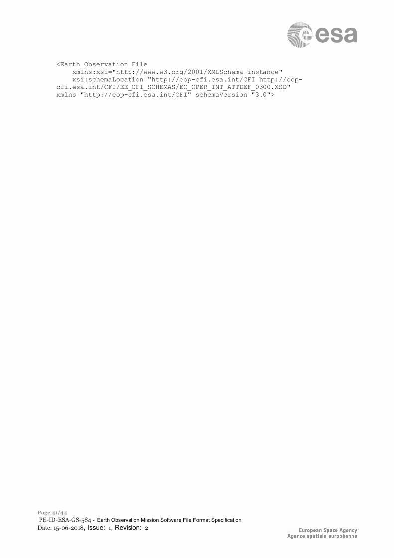
ESA UNCLASSIFIED – Releasable to the Public
Page 41/44 PE-ID-ESA-GS-584 - Earth Observation Mission Software File Format Specification Date: 15-06-2018, Issue: 1, Revision: 2
<Earth_Observation_File xmlns:xsi="http://www.w3.org/2001/XMLSchema-instance" xsi:schemaLocation="http://eop-cfi.esa.int/CFI http://eop-cfi.esa.int/CFI/EE_CFI_SCHEMAS/EO_OPER_INT_ATTDEF_0300.XSD" xmlns="http://eop-cfi.esa.int/CFI" schemaVersion="3.0">
ESA UNCLASSIFIED – Releasable to the Public
Page 42/44 PE-ID-ESA-GS-584 - Earth Observation Mission Software File Format Specification Date: 15-06-2018, Issue: 1, Revision: 2
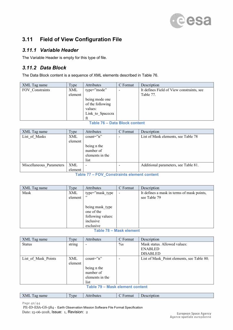
3.11 Field of View Configuration File
3.11.1 Variable Header The Variable Header is empty for this type of file.
3.11.2 Data Block The Data Block content is a sequence of XML elements described in Table 76. XML Tag name Type Attributes C Format Description FOV_Constraints XML
element type=”mode” being mode one of the following values: Link_to_Spacecraft
- It defines Field of View constraints, see Table 77.
Table 76 – Data Block content
XML Tag name Type Attributes C Format Description List_of_Masks XML
element count=”n” being n the number of elements in the list
- List of Mask elements, see Table 78
Miscellaneous_Parameters XML element
- - Additional parameters, see Table 81.
Table 77 – FOV_Constraints element content
XML Tag name Type Attributes C Format Description Mask XML
element type=”mask_type” being mask_type one of the following values: inclusive exclusive
- It defines a mask in terms of mask points, see Table 79
Table 78 – Mask element
XML Tag name Type Attributes C Format Description Status string - %s Mask status. Allowed values:
ENABLED DISABLED
List_of_Mask_Points XML element
count=”n” being n the number of elements in the list
- List of Mask_Point elements, see Table 80.
Table 79 – Mask element content
XML Tag name Type Attributes C Format Description
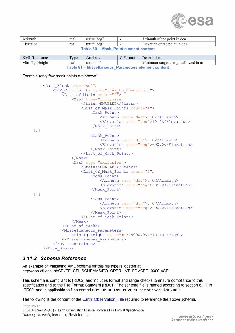
ESA UNCLASSIFIED – Releasable to the Public
Page 43/44 PE-ID-ESA-GS-584 - Earth Observation Mission Software File Format Specification Date: 15-06-2018, Issue: 1, Revision: 2
Azimuth real unit=”deg” - Azimuth of the point in deg Elevation real unit=”deg” - Elevation of the point in deg
Table 80 – Mask_Point element content
XML Tag name Type Attributes C Format Description Min_Tg_Height real unit=”m” - Minimum tangent height allowed in m
Table 81 – Miscellaneous_Parameters element content
Example (only few mask points are shown):
<Data_Block type="xml"> <FOV_Constraints type="Link_to_Spacecraft"> <List_of_Masks count="2"> <Mask type="inclusive"> <Status>ENABLED</Status> <List_of_Mask_Points count="4"> <Mask_Point> <Azimuth unit="deg">0.0</Azimuth> <Elevation unit="deg">10.0</Elevation> </Mask_Point> […] <Mask_Point> <Azimuth unit="deg">0.0</Azimuth> <Elevation unit="deg">-90.0</Elevation> </Mask_Point> </List_of_Mask_Points> </Mask> <Mask type="exclusive"> <Status>ENABLED</Status> <List_of_Mask_Points count="8"> <Mask_Point> <Azimuth unit="deg">0.0</Azimuth> <Elevation unit="deg">-85.0</Elevation> </Mask_Point> […] <Mask_Point> <Azimuth unit="deg">0.0</Azimuth> <Elevation unit="deg">-90.0</Elevation> </Mask_Point> </List_of_Mask_Points> </Mask> </List_of_Masks> <Miscellaneous_Parameters> <Min_Tg_Height unit="m">19000.0</Min_Tg_Height> </Miscellaneous_Parameters> </FOV_Constraints> </Data_Block>
3.11.3 Schema Reference An example of validating XML schema for this file type is located at: http://eop-cfi.esa.int/CFI/EE_CFI_SCHEMAS/EO_OPER_INT_FOVCFG_0300.XSD This schema is compliant to [RD02] and includes format and range checks to ensure compliance to this specification and to the File Format Standard [RD01]. The schema file is named according to section 6.1.1 in [RD02] and is applicable to files named MMM_OPER_INT_FOVCFG_<instance_id>.EOF. The following is the content of the Earth_Observation_File required to reference the above schema.

ESA UNCLASSIFIED – Releasable to the Public
Page 44/44 PE-ID-ESA-GS-584 - Earth Observation Mission Software File Format Specification Date: 15-06-2018, Issue: 1, Revision: 2
<Earth_Observation_File xmlns:xsi="http://www.w3.org/2001/XMLSchema-instance" xsi:schemaLocation="http://eop-cfi.esa.int/CFI http://eop-cfi.esa.int/CFI/EE_CFI_SCHEMAS/EO_OPER_INT_FOVCFG_0300.XSD" xmlns="http://eop-cfi.esa.int/CFI" schemaVersion="3.0">

![[MS-PROPSTORE]: Property Store Binary File Format · 2017-09-06 · This document specifies the Microsoft Property Store Binary File Format. This file format is a persistence format](https://img.pdfslide.us/doc/110x75/5f7ccbe3f4ebc4690b1ce56b/ms-propstore-property-store-binary-file-format-2017-09-06-this-document-specifies.jpg)
![[MS-CSDLBI-Diff]: Conceptual Schema Definition File Format ...MS... · Conceptual Schema Definition File Format with Business ... Conceptual Schema Definition File Format with Business](https://img.pdfslide.us/doc/110x75/5cd72bdf88c993dc268c1c36/ms-csdlbi-diff-conceptual-schema-definition-file-format-ms-conceptual.jpg)