Embed Size (px)
Citation preview

Earth Explorer Missions
EE7 and EE8
Portugal Bilateral| 11 June 2012 |V1 | Pag. 1
Stephen Briggs
Head of Programme Planning and Coordination Service
Directorate of ESA Earth Observation Programmes
Lisbon, Portugal
11 June 2012

The EE mission candidates
EE-7: Biomass, CoReH2O, PREMIER
Portugal Bilateral| 11 June 2012 |V1 | Pag. 2
EE-8: CarbonSat, FLEX

Portugal Bilateral| 11 June 2012 |V1 | Pag. 3
Status of the BIOMASS missionAN ESA EARTH EXPLORER CANDIDATE TO MEASURE THE BIOMASS OF THE EARTH’S FORESTS

Mission overview: scope and objectives of the mission
– BIOMASS will be the first satellite to observe the Earth from space with a P-
band SAR
– This will allow exploiting the sensitivity of P-band signal to forest biomasses.
The figure indicates areas of interest
– The primary scientific objectives are to determine the distribution of
aboveground biomass in the world forest and to measure changes in this stock
over the 5 year period of the mission
Portugal Bilateral| 11 June 2012 |V1 | Pag. 4
over the 5 year period of the mission

BIOMASS observation concept
Calibration, Ionospheric correctionCalibration, Ionospheric correction
Polarimetric
Interferometric
Orbit cycle n
Orbit cycle n+1
Portugal Bilateral| 11 June 2012 |V1 | Pag. 5
Retrieval algorithmRetrieval algorithm
• Forest biomass
• Forest height
• Forest biomass temporal change
• Forest disturbance
• Forest biomass
• Forest height
• Forest biomass temporal change
• Forest disturbance
Polarimetric radar
intensity
Interferometric
PhaseHH
HVVV Phase

Satellite Mass: ~ 1080 kgSatellite Power: ~ 700 W
Quad-pol P-band SAR payload based on 12 m diameter
Overview of implementation concept (3/3) Payload
Portugal Bilateral| 11 June 2012 |V1 | Pag. 6
P-band SAR operates in interleaved stripmap mode
based on 12 m diameter unfurlable mesh reflector
P-band feed array (example, after Thales Alenia)

Portugal Bilateral| 11 June 2012 |V1 | Pag. 7
ESA UNCLASSIFIED – For Official Use
Status of the CoReH20 missionAN ESA EARTH EXPLORER CANDIDATE TO OBSERVE SNOW AND ICE
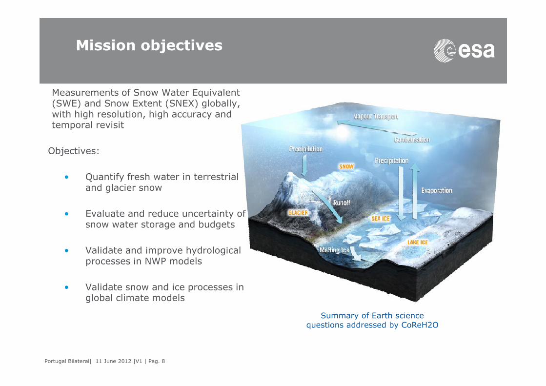
Mission objectives
Measurements of Snow Water Equivalent (SWE) and Snow Extent (SNEX) globally, with high resolution, high accuracy and temporal revisit
Objectives:
• Quantify fresh water in terrestrial and glacier snow
Portugal Bilateral| 11 June 2012 |V1 | Pag. 8
• Evaluate and reduce uncertainty of snow water storage and budgets
• Validate and improve hydrological processes in NWP models
• Validate snow and ice processes in global climate models
Summary of Earth science questions addressed by CoReH2O

Observation concept
– Observation concept
– X/Ku-band simultaneous SAR observations at VV-VH
polarisations
– Snow & Sea Ice areas coverage with wide swath (100 km)
– Mission profile: highly repeatable and automated mission
– Phase 1 (year 1 & 2): 3 days revisit (~666 km altitude)
– Phase 2 (year 3+): 15 days revisit (~645 km altitude)
Portugal Bilateral| 11 June 2012 |V1 | Pag. 9
– Phase 2 (year 3+): 15 days revisit (~645 km altitude)
Backscatter contributions:Volume, surface, and interaction terms

Overview of implementation concept Satellite and launcher
Mass 1300 kg
Powe
r
~2.5 kW
orbit average
Size 4.3 m x 1.8 m
reflector
Satellite concept #1 Main parameters
Portugal Bilateral| 11 June 2012 |V1 | Pag. 10
Satellite concept #2 Launchers & interfaces

Portugal Bilateral| 11 June 2012 |V1 | Pag. 11
Status of the PREMIER missionAN ESA EARTH EXPLORER CANDIDATE TO OBSERVE ATMOSPHERIC COMPOSITION
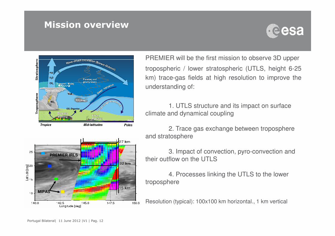
Mission overview
PREMIER will be the first mission to observe 3D upper
tropospheric / lower stratospheric (UTLS, height 6-25
km) trace-gas fields at high resolution to improve the
understanding of:
1. UTLS structure and its impact on surface
climate and dynamical coupling
Portugal Bilateral| 11 June 2012 |V1 | Pag. 12
2. Trace gas exchange between troposphere
and stratosphere
3. Impact of convection, pyro-convection and
their outflow on the UTLS
4. Processes linking the UTLS to the lower
troposphere
Resolution (typical): 100x100 km horizontal., 1 km vertical
PREMIER IRLS
MIPAS

PREMIER observation concept
MetOp Swath
IRLS Sampling
(illustration)
STEAMR sampling
(illustration
)
V
MetOp
PREMIER
• PREMIER will observe 3D atmospheric composition fields
through the use of Infra-Red limb imaging spectrometry.
Millimetre-wave limb sounding will provide 2D data in
presence of cirrus clouds and complementary chemical
species
• PREMIER data will be extended to the surface through
the synergy with nadir observations from MetOp
Portugal Bilateral| 11 June 2012 |V1 | Pag. 13
METOPPREMIER
V
V • Infra-Red (IRLS) and mm-wave (STEAMR) limb
sounding (latter sensor provided in-kind by Sweden)
• Loose formation with MetOp to ensure synergy with
MetOp nadir-looking observations
• Co-registered measurements of IRLS, STEAMR and
MetOp
Vinstruments, improving estimates of biogenic, pyrogenic
and anthropogenic emissions

Overview implementation concepts: Instruments
Fourier transform spectrometer in the infrared (710 – 1650
cm-1) Two operational modes (Chemistry and Dynamics)1167
1713
mm
1749
mm
IRLS STEAMR
Portugal Bilateral| 11 June 2012 |V1 | Pag. 14
cm-1) Two operational modes (Chemistry and Dynamics)
Vertical Spatial Sampling: 600 - 700 m
Across/along Track Spatial Sampling: 15 - 16 km / 50 km
FoV : 350 - 360 km across track, ~50 km vertical
Cooled (240 K) and room temperature (290 K) instrument
concepts
Cryo-cooled focal plane array at 50 K
Mass: ~200 kg
Power: ~450 W
1167
mm
– Mass: ~120 kg
– Power EOL: ~450 W
– Stringent reflector illumination conditions.

EE-7 : Overall status of activities
• Phase A includes the end-to-end preparation of the complete system, including
space and ground segments. The challenges are in the space segment
(satellite, especially payload). For the ground segment, no special requirements
exist, except for PREMIER, which has a near-real time (3 to 5 hours)
requirement for the delivery of Level 1b products.
• Phase A system studies completed with Preliminary Requirements Reviews
• System and science support activities also completed. Technology activities
Portugal Bilateral| 11 June 2012 |V1 | Pag. 15
• System and science support activities also completed. Technology activities
completed or generally with very good progress to ensure that Technology
Readiness Level (TRL) 5 is reached either at mission selection or latest at the
end of Phase B1 – differently from past, no implementation phase shall start
until TRL 5 is secured
• End-to-end (E2E) mission performance simulators (one per mission) developed
for assessing the quality of retrieved products at Level 1 and Level 2
• Phase A Extension activities, covering all aspects (system, science, E2E
simulations, technologies,..) initiated, to last until ~ October 2012 – results in delta reports and presentations to the User Consultation Meeting in Q1 2013

Earth Explorer 8 (EE8): CarbonSat
Portugal Bilateral| 11 June 2012 |V1 | Pag. 16
CarbonSat: to quantify and monitor the distribution of carbon dioxide and methane
=> better understanding of the sources and sinks of these two gases and how they
are linked to climate change.

CarbonSat (1)
Scientific and societally-relevant objectives:
• to quantify magnitudes and spatial and temporal distributions of CO2 and CH4 sources and sinks from regional to sub-urban scales;
• to identify the CO2 uptake mechanisms of the terrestrial biosphere and oceans;
• to determine the response of CO2 and CH4 sources and sinks to a changing
Portugal Bilateral| 11 June 2012 |V1 | Pag. 17
• to determine the response of CO2 and CH4 sources and sinks to a changing climate;
• to contribute to treaty verification of UNFCCC and post-Copenhagen agreements.
Flux inversion using models in conjunction with measurements of CO2 and CH4 fields will allow scientists to quantify anthropogenic and natural localized sources of CH4 and CO2 (hot spot emissions) from space for the first time.
Additionally, the larger scale biogenetic sinks for CO2 over land and ocean and the atmospheric destruction of CH4 will be accurately determined.
CarbonSat (2)
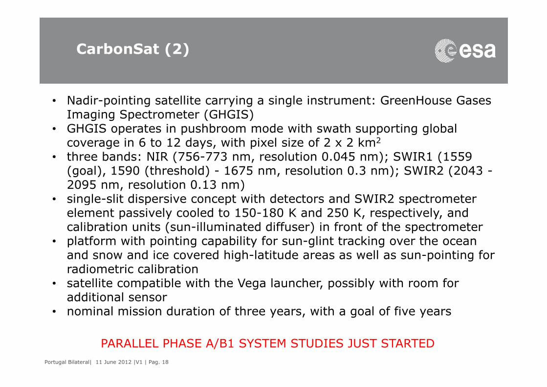
• Nadir-pointing satellite carrying a single instrument: GreenHouse Gases Imaging Spectrometer (GHGIS)
• GHGIS operates in pushbroom mode with swath supporting global coverage in 6 to 12 days, with pixel size of 2 x 2 km2
• three bands: NIR (756-773 nm, resolution 0.045 nm); SWIR1 (1559 (goal), 1590 (threshold) - 1675 nm, resolution 0.3 nm); SWIR2 (2043 -2095 nm, resolution 0.13 nm)
• single-slit dispersive concept with detectors and SWIR2 spectrometer
Portugal Bilateral| 11 June 2012 |V1 | Pag. 18
• single-slit dispersive concept with detectors and SWIR2 spectrometer element passively cooled to 150-180 K and 250 K, respectively, and calibration units (sun-illuminated diffuser) in front of the spectrometer
• platform with pointing capability for sun-glint tracking over the ocean and snow and ice covered high-latitude areas as well as sun-pointing for radiometric calibration
• satellite compatible with the Vega launcher, possibly with room for additional sensor
• nominal mission duration of three years, with a goal of five years
PARALLEL PHASE A/B1 SYSTEM STUDIES JUST STARTED

Earth Explorer 8 (EE8): FLEX
Portugal Bilateral| 11 June 2012 |V1 | Pag. 19
FLEX: to provide global maps of vegetation fluorescence, which can be converted
into an indicator of photosynthetic activity => better understanding of how much
carbon is stored in plants and their role in the carbon and water cycles
FLEX (1)
Two main scientific objectives:
1. to provide, for the first time, space-based maps of vegetation fluorescence, which can be converted into a quantitative indicator of photosynthetic efficiency rates of terrestrial ecosystems
2. on the strength of evidence that canopy fluorescence is closely correlated with ecosystem carbon uptake, to provide measurements
Portugal Bilateral| 11 June 2012 |V1 | Pag. 20
correlated with ecosystem carbon uptake, to provide measurements that can be used to improve models of vegetation gross primary production
FLEX will take advantage of additional measurements provided by the Ocean and Land Colour Instrument (OLCI) and the Sea and Land Surface Temperature radiometer (SLST) onboard Sentinel-3
The combined information is critical to resolve the disagreements between different land models that attempt to simulate future atmospheric CO2 concentrations through interactive terrestrial carbon balances

FLEX (2)
• satellite flying in tandem with Sentinel-3 - observations of FLEX and S-3 acquired within 6 to 15 s from each other
• payload: FLuORescence Imaging Spectrometer (FLORIS) measuring fluorescence in O2-A and O2-B bands plus reflectance over red-edge and Photochemical Reflectance Index (PRI) spectral ranges
• OLCI and the SLSTR on S-3 provide complementary information to measure fluorescence signal
FLORIS operates in pushbroom mode with a swath of 100 to 150 km (contained within one of
Portugal Bilateral| 11 June 2012 |V1 | Pag. 21
• FLORIS operates in pushbroom mode with a swath of 100 to 150 km (contained within one of the S-3 OLCI camera swath) and a pixel size of 0.3 x 0.3 km2
• data in four spectral bands: O2-A (750-777 nm); O2-B (660-714 nm); red edge (714-750 nm); PRI (520-660 nm) with sampling of 0.1 nm in oxygen bands and 0.5 to 2 nm in red edge and PRI bands
• calibration relies on both cross-calibration with the equivalent bands of OLCI and dedicated devices
• FLEX and S-3 images co-registered by on-ground processing through correlation algorithms.
• Vega launcher as baseline and mission duration of nominally 3.5 y (to cover at least 3 full vegetation growth cycles) with goal of 5 y
PARALLEL PHASE A/B1 SYSTEM STUDIES KICKED OFF IN Q1 OF 2012