Embed Size (px)
Citation preview
Ž .Earth and Planetary Science Letters 152 1997 267–274
Express Letter
Early Tertiary gravity field reconstructions of the SouthwestPacific
K.M. Marks a,), J.M. Stock b
a NOAA Laboratory for Satellite Altimetry, ErOC2, SilÕer Spring, MD 20910, USAb Caltech 252-21, Pasadena, CA 91125, USA
Received 10 June 1997; accepted 12 August 1997
Abstract
The aim of our study is to chronicle the development of plate boundaries in the Southwest Pacific Ocean during the earlyTertiary. This region has been the subject of numerous and often conflicting studies that have attempted to construct thehistory of plate motion and plate boundary evolution as the Australia and Pacific plates separated from Antarctica. Our novelapproach entails reconstructing gravity fields from satellite altimeter gravity by first removing anomalies overlying seaflooryounger than a selected age, and then rotating the remaining anomalies through appropriate finite rotations. Our
Ž . Ž .reconstructions reveal: 1 an extensional plate boundary the Iselin rift existed between West and East Antarctica prior toŽ . Ž . Ž .A24 time; 2 the arrival of the Southeast Indian ridge SEIR at the Tasman ridge prior to A24 led to the extinction of the
ŽIselin rift as well as the conversion of the easternmost portion of the Tasman plate boundary between the SEIR and the. Ž . Ž .Iselin rift into a transform fault on the Pacific–Antarctic ridge; and 3 an early A24 or younger inception of the
Australia–Pacific plate boundary. Our scenario for the opening of the Southwest Pacific Ocean can explain the present-daygravity anomalies and magnetic isochrons observed in the northwest Ross Sea. We find that the East Antarctic seafloornortheast of the Iselin Bank was generated by spreading on the Tasman ridge prior to A24 time. q 1997 Elsevier ScienceB.V.
Keywords: Southwest Pacific; lower Tertiary; gravity anomalies; Geosat; plate tectonics; reconstruction
1. Introduction
w xHigh resolution gravity fields 1,2 covering theworld’s oceans between 728N and 728S have beenused to study the fine-scale tectonic features of the
Ž w x.seafloor e.g., 3–6 . Recent advances in extractinggravity information from ERS-1 altimeter ice returnsw x7,8 has extended this coverage of the oceans to818N and 798S. In this study, we combine McAdoo
w xand Laxon’s 8 ERS-1 gravity field over the usually
) Corresponding author. Tel.: q1 301 713 2860, ext. 124. Fax:q1 301 713 4598. E-mail: [email protected]
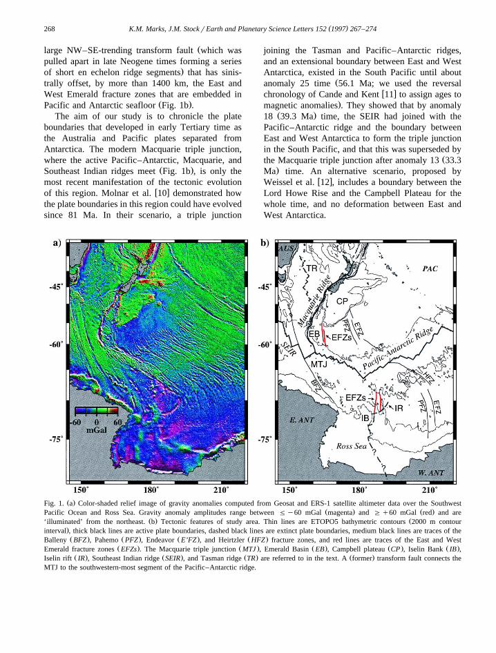
ice-covered southern Ross Sea with Geosat gravityw x1 over the northern Ross Sea and Southwest Pacific
Ž .Ocean Fig. 1a . In this extended gravity field, con-jugate sections of tectonic features such as the Pa-
w xhemo and Endeavor fracture zones 9 are clearlyvisible near the margins of the Campbell plateau and
w xAntarctica; and the Iselin rift 8 , as well as itspossible southward extension into the Ross Embay-
Ž .ment Fig. 1b , is visualized. A complex history ofmotion between the Australia, Pacific, and Antarcticplates is inferred from the twisted and truncatedfracture zones in the Emerald Basin and the conju-gate region of the South Tasman Sea, and from the
0012-821Xr97r$17.00 q 1997 Elsevier Science B.V. All rights reserved.Ž .PII S0012-821X 97 00139-8
( )K.M. Marks, J.M. StockrEarth and Planetary Science Letters 152 1997 267–274268
Žlarge NW–SE-trending transform fault which waspulled apart in late Neogene times forming a series
.of short en echelon ridge segments that has sinis-trally offset, by more than 1400 km, the East andWest Emerald fracture zones that are embedded in
Ž .Pacific and Antarctic seafloor Fig. 1b .The aim of our study is to chronicle the plate
boundaries that developed in early Tertiary time asthe Australia and Pacific plates separated fromAntarctica. The modern Macquarie triple junction,where the active Pacific–Antarctic, Macquarie, and
Ž .Southeast Indian ridges meet Fig. 1b , is only themost recent manifestation of the tectonic evolution
w xof this region. Molnar et al. 10 demonstrated howthe plate boundaries in this region could have evolvedsince 81 Ma. In their scenario, a triple junction
joining the Tasman and Pacific–Antarctic ridges,and an extensional boundary between East and WestAntarctica, existed in the South Pacific until about
Žanomaly 25 time 56.1 Ma; we used the reversalw xchronology of Cande and Kent 11 to assign ages to
.magnetic anomalies . They showed that by anomalyŽ .18 39.3 Ma time, the SEIR had joined with the
Pacific–Antarctic ridge and the boundary betweenEast and West Antarctica to form the triple junctionin the South Pacific, and that this was superseded by
Žthe Macquarie triple junction after anomaly 13 33.3.Ma time. An alternative scenario, proposed by
w xWeissel et al. 12 , includes a boundary between theLord Howe Rise and the Campbell Plateau for thewhole time, and no deformation between East andWest Antarctica.
Ž .Fig. 1. a Color-shaded relief image of gravity anomalies computed from Geosat and ERS-1 satellite altimeter data over the SouthwestŽ . Ž .Pacific Ocean and Ross Sea. Gravity anomaly amplitudes range between Fy60 mGal magenta and Gq60 mGal red and are
Ž . Ž‘illuminated’ from the northeast. b Tectonic features of study area. Thin lines are ETOPO5 bathymetric contours 2000 m contour.interval , thick black lines are active plate boundaries, dashed black lines are extinct plate boundaries, medium black lines are traces of theŽ . Ž . Ž . Ž .Balleny BFZ , Pahemo PFZ , Endeavor E’FZ , and Heirtzler HFZ fracture zones, and red lines are traces of the East and West
Ž . Ž . Ž . Ž . Ž .Emerald fracture zones EFZs . The Macquarie triple junction MTJ , Emerald Basin EB , Campbell plateau CP , Iselin Bank IB ,Ž . Ž . Ž . Ž .Iselin rift IR , Southeast Indian ridge SEIR , and Tasman ridge TR are referred to in the text. A former transform fault connects the
MTJ to the southwestern-most segment of the Pacific–Antarctic ridge.
( )K.M. Marks, J.M. StockrEarth and Planetary Science Letters 152 1997 267–274 269
While some of our results are in agreement withw xthe scenario of Molnar et al. 10 , an important
difference is that we determined that the SEIRŽreached the Tasman ridge prior to anomaly 24 53.35
.Ma , and that its juncture westward of the triplejunction joining the Tasman and Pacific–Antarcticridges with the boundary between East and WestAntarctica led to the cessation of extension within
w xpart of Antarctica, along the Iselin rift 8 , as well asthe conversion of the easternmost portion of the
ŽTasman plate boundary between the Iselin rift and.the SEIR into a large transform fault on the
ŽPacific–Antarctic ridge. We suggest an earlier A24.or younger inception of the Australia–Pacific diver-
Ž .gent plate boundary i.e. the Macquarie ridge thanw x w xMolnar et al. 10 , Weissel et al. 12 , Sutherland
w x w x13 , Wood et al. 14 , and others. Our reconstruc-tions do not require the co-existence of two triple
w xjunctions 15 or the complex plate boundary junc-Ž w x.tures proposed by some researchers e.g., 16 , or a
triple junction that joins the SEIR with the Pacific–Ž w x.Antarctic ridge and the Iselin rift e.g., 10 . A
discussion of how we reconstructed our gravity fields,and interpreted them as highlighted above, follows.
2. Method and results
( )2.1. Chron 27 61.1 Ma
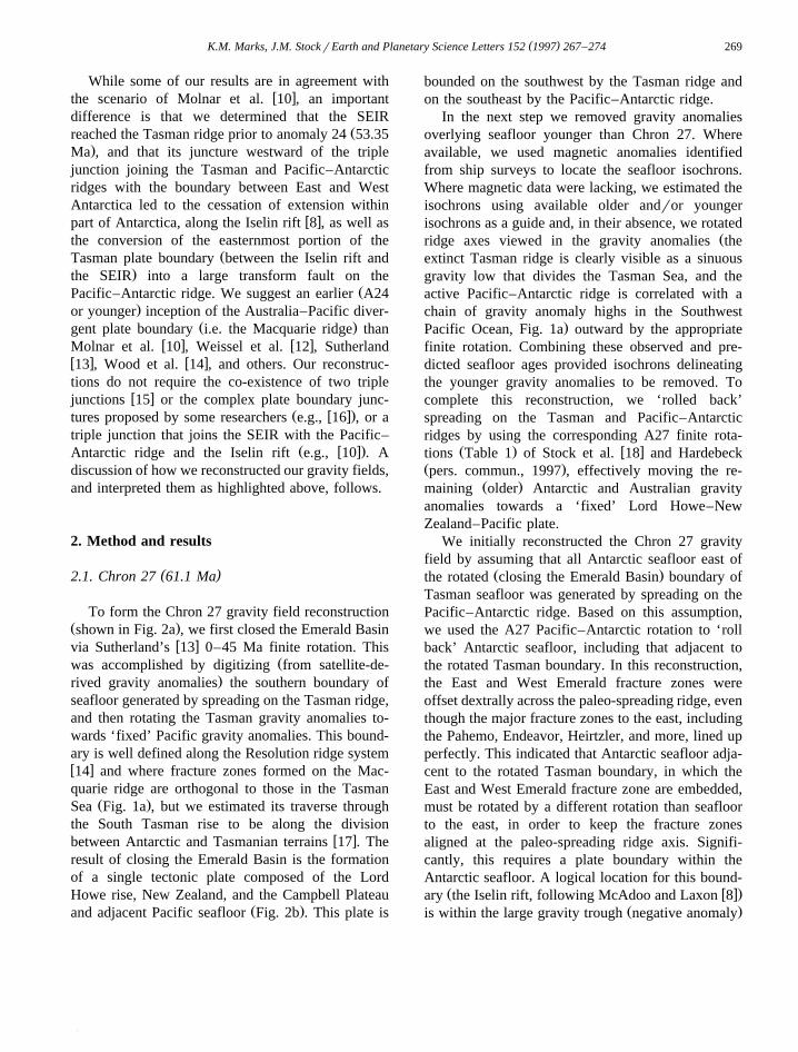
To form the Chron 27 gravity field reconstructionŽ .shown in Fig. 2a , we first closed the Emerald Basin
w xvia Sutherland’s 13 0–45 Ma finite rotation. ThisŽwas accomplished by digitizing from satellite-de-
.rived gravity anomalies the southern boundary ofseafloor generated by spreading on the Tasman ridge,and then rotating the Tasman gravity anomalies to-wards ‘fixed’ Pacific gravity anomalies. This bound-ary is well defined along the Resolution ridge systemw x14 and where fracture zones formed on the Mac-quarie ridge are orthogonal to those in the Tasman
Ž .Sea Fig. 1a , but we estimated its traverse throughthe South Tasman rise to be along the division
w xbetween Antarctic and Tasmanian terrains 17 . Theresult of closing the Emerald Basin is the formationof a single tectonic plate composed of the LordHowe rise, New Zealand, and the Campbell Plateau
Ž .and adjacent Pacific seafloor Fig. 2b . This plate is
bounded on the southwest by the Tasman ridge andon the southeast by the Pacific–Antarctic ridge.
In the next step we removed gravity anomaliesoverlying seafloor younger than Chron 27. Whereavailable, we used magnetic anomalies identifiedfrom ship surveys to locate the seafloor isochrons.Where magnetic data were lacking, we estimated theisochrons using available older andror youngerisochrons as a guide and, in their absence, we rotated
Žridge axes viewed in the gravity anomalies theextinct Tasman ridge is clearly visible as a sinuousgravity low that divides the Tasman Sea, and theactive Pacific–Antarctic ridge is correlated with achain of gravity anomaly highs in the Southwest
.Pacific Ocean, Fig. 1a outward by the appropriatefinite rotation. Combining these observed and pre-dicted seafloor ages provided isochrons delineatingthe younger gravity anomalies to be removed. Tocomplete this reconstruction, we ‘rolled back’spreading on the Tasman and Pacific–Antarcticridges by using the corresponding A27 finite rota-
Ž . w xtions Table 1 of Stock et al. 18 and HardebeckŽ .pers. commun., 1997 , effectively moving the re-
Ž .maining older Antarctic and Australian gravityanomalies towards a ‘fixed’ Lord Howe–NewZealand–Pacific plate.
We initially reconstructed the Chron 27 gravityfield by assuming that all Antarctic seafloor east of
Ž .the rotated closing the Emerald Basin boundary ofTasman seafloor was generated by spreading on thePacific–Antarctic ridge. Based on this assumption,we used the A27 Pacific–Antarctic rotation to ‘rollback’ Antarctic seafloor, including that adjacent tothe rotated Tasman boundary. In this reconstruction,the East and West Emerald fracture zones wereoffset dextrally across the paleo-spreading ridge, eventhough the major fracture zones to the east, includingthe Pahemo, Endeavor, Heirtzler, and more, lined upperfectly. This indicated that Antarctic seafloor adja-cent to the rotated Tasman boundary, in which theEast and West Emerald fracture zone are embedded,must be rotated by a different rotation than seafloorto the east, in order to keep the fracture zonesaligned at the paleo-spreading ridge axis. Signifi-cantly, this requires a plate boundary within theAntarctic seafloor. A logical location for this bound-
Ž w x.ary the Iselin rift, following McAdoo and Laxon 8Ž .is within the large gravity trough negative anomaly
( )K.M. Marks, J.M. StockrEarth and Planetary Science Letters 152 1997 267–274270
( )K.M. Marks, J.M. StockrEarth and Planetary Science Letters 152 1997 267–274 271
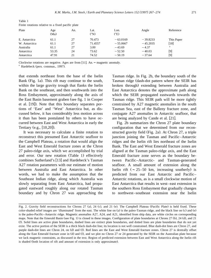
Table 1Finite rotations relative to a fixed pacific plate
Plate Age An. Lat. Lon. Angle ReferenceŽ . Ž . Ž .Ma 8N 8E
E. Antarctica 61.1 27 70.473 y63.0169 y39.8233 This Paperw xW. Antarctica 61.1 27 71.4557 y55.0667 y45.2035 18aAustralia 61.1 27 3.00 y43.69 y4.37w xAntarctica 53.35 24 73.62 y52.50 y40.03 9w xAntarctica 47.91 21 74.52 y50.19 y37.64 9
w xClockwise rotations are negative. Ages are from 11 . An.smagnetic anomaly.a Ž .Hardebeck pers. commun., 1997 .
that extends northeast from the base of the IselinŽ .Bank Fig. 1a . This rift may continue to the south,
within the large gravity trough that flanks the IselinBank on the southeast, and then southwards into theRoss Embayment, approximately along the axis of
Žthe East Basin basement graben see fig. 1 in Cooperw x.et al. 19 . Note that this boundary separates por-
tions of ‘East’ and ‘West’ Antarctica but, as dis-cussed below, it has considerably less motion acrossit than has been postulated by others to have oc-curred between East and West Antarctica in early the
Ž w x.Tertiary e.g., 10,20 .It was necessary to calculate a finite rotation to
reconstruct this presumed East Antarctic seafloor tothe Campbell Plateau, a rotation that would align theEast and West Emerald fracture zones at the Chron27 paleo-ridge axis, which we accomplished by trial
Ž .and error. Our new rotation Table 1 effectivelyw xcombines Sutherland’s 13 and Hardebeck’s Tasman
A27 rotation parameters with our estimate of motionbetween Australia and East Antarctica. In otherwords, we had to make the assumption that theSoutheast Indian ridge, along which Australia wasslowly separating from East Antarctica, had propa-gated eastward roughly along our rotated Tasmanboundary and by Chron 27 was approaching the
Tasman ridge. In Fig. 2b, the boundary south of theŽTasman ridge dash-dot pattern where the SEIR has.broken through extending between Australia and
East Antarctica denotes the approximate path alongwhich the SEIR propagated eastwards towards theTasman ridge. This SEIR path will be more tightlyconstrained by A27 magnetic anomalies in the southTasman Sea, east of the Balleny fracture zone, andconjugate A27 anomalies in Antarctic seafloor, that
w xare being analyzed by Cande et al. 21 .Fig. 2b summarizes the Chron 27 plate boundary
configuration that we determined from our recon-Ž .structed gravity field Fig. 2a . At Chron 27, a triple
junction joining the Tasman and Pacific–Antarcticridges and the Iselin rift lies northeast of the IselinBank. The East and West Emerald fracture zones arealigned at the Tasman paleo-ridge axis, and the EastEmerald fracture zone serves as the boundary be-tween Pacific–Antarctic- and Tasman-generatedseafloor. A small amount of extension along the
Ž .Iselin rift ;25–50 km, increasing southerly ispredicted from our East Antarctic and Pacific–Antarctic rotations, as is a small clockwise motion ofEast Antarctica that results in west–east extension inthe southern Ross Embayment that gradually changesto northwest–southeast extension near the Iselin
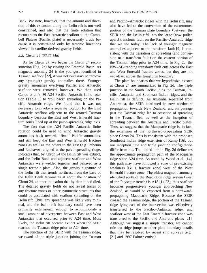
Ž . Ž . Ž . Ž .Fig. 2. Gravity field reconstructions for Chrons 27 a , 24 c , and 21 e . The Campbell Plateau Pacific Plate is held fixed. TheseŽ . Ž . Ž .color-shaded relief images are ‘illuminated’ from the east. The white line on a is the paleo-Tasman ridge, and the black line on c and e
is the paleo-Pacific–Antarctic ridge. Magnetic anomalies A27, A24, and A21, identified from ship data, are white circles on correspondingŽ . Ž . Ž .maps. Note that the Emerald Basin see Fig. 1 is closed in these images. Configuration of plate boundaries at Chrons 27 b , 24 d , and 21
Ž .f . Solid lines are active plate boundaries, dashed lines are extinct plate boundaries, and dotted lines are plate boundaries that do not yetexist. The active portion of the SEIR is a thick black dash-dot line; its location is not well constrained. Blue dash-dot lines are Chron 27, and
Ž . Ž .purple dash-dot lines are Chron 24, on d and f . Red lines are the East and West Emerald fracture zones. Chron 27 is dextrally offsetŽ . Ž .along the East Emerald fracture zone in d and f , and we plot no Chron 27 or 24 generated by the SEIR on the Australian plate because
we lack magnetic constraints, as discussed in the text. Region of predicted extension between East and West Antarctica along the Iselin riftŽ .is shaded both location of rift and amount of extension is only approximate .
( )K.M. Marks, J.M. StockrEarth and Planetary Science Letters 152 1997 267–274272
Bank. We note, however, that the amount and direc-tion of this extension along the Iselin rift is not wellconstrained, and also that the finite rotation thatreconstructs the East Antarctic seafloor to the Camp-
Ž .bell Plateau Pacific plate is necessarily crude be-cause it is constrained only by tectonic lineationsviewed in satellite-derived gravity fields.
( )2.2. Chron 24 53.35 Ma
As for Chron 27, we began the Chron 24 recon-Ž .struction Fig. 2c by closing the Emerald Basin. As
magnetic anomaly 24 is the youngest identified inw xTasman seafloor 22 , it was not necessary to remove
Ž .any younger gravity anomalies there. Youngergravity anomalies overlying Pacific and Antarcticseafloor were removed, however. We then used
w xCande et al.’s 9 A24 Pacific–Antarctic finite rota-Ž .tion Table 1 to ‘roll back’ spreading on the Pa-
cific–Antarctic ridge. We found that it was notnecessary to invoke a separate rotation for the EastAntarctic seafloor adjacent to the rotated Tasmanboundary because the East and West Emerald frac-ture zones lined up at the paleo-spreading ridge axis.
The fact that the A24 Pacific–Antarctic finiterotation could be used to wind Antarctic gravityanomalies back towards ‘fixed’ Pacific anomalies,and still keep the East and West Emerald fracture
Žzones as well as the others to the east e.g. Pahemo.and Endeavor aligned at the paleo-spreading ridge,
indicates that, by Chron 24 the Iselin rift was extinct,and the Iselin Bank and adjacent seafloor and WestAntarctica were welded together and behaved as asingle tectonic plate. Also, the gravity signature ofthe Iselin rift that trends northeast from the base ofthe Iselin Bank terminates at about the position ofChron 24, another indication that by then it had died.The detailed gravity fields do not reveal traces ofany fracture zones or other symmetric structures thatcould be associated with seafloor spreading on theIselin rift. Thus, any spreading was likely very mini-mal, and the Iselin rift boundary could have beenprimarily extensional, enough to accommodate asmall amount of divergence between East and WestAntarctica that occurred prior to A24 time. Mostlikely, the Iselin rift became extinct when the SEIRreached the Tasman ridge prior to A24 time.
The juncture of the SEIR with the Tasman ridge,westward of the triple junction joining the Tasman
and Pacific–Antarctic ridges with the Iselin rift, mayalso have led to the conversion of the easternmost
Žportion of the Tasman plate boundary between the. ŽSEIR and the Iselin rift into the large now pulled
.apart transform fault on the Pacific–Antarctic ridgethat we see today. The lack of younger magnetic
w xanomalies adjacent to the transform fault 9 is con-Žsistent with the cessation of spreading and conver-
.sion to a transform fault on the eastern portion ofthe Tasman ridge prior to A24 time. In Fig. 2c, theNW–SE-trending transform fault cuts across the Eastand West Emerald fracture zones, but they are notyet offset across the transform boundary.
The plate boundaries that we hypothesize existedat Chron 24 are summarized in Fig. 2d. The triplejunction in the South Pacific joins the Tasman, Pa-cific–Antarctic, and Southeast Indian ridges, and theIselin rift is defunct. As Australia separated fromAntarctica, the SEIR continued its now northwardpropagation towards New Zealand, and its passagepast the Tasman ridge led to cessation of spreadingin the Tasman Sea, as well as the inception ofspreading between the Australia and Pacific plates.Thus, we suggest that the Macquarie ridge is, in fact,the extension of the northward-propagating SEIRsince Chron 24. This is consistent with the proposed
w xSoutheast Indian ridge extension of Kamp 16 , butour inception time and triple junction configurationdiffer from his. The dotted line in Fig. 2d delineatesthe approximate propagation path of the Macquarie
w xridge since A24 time. As noted by Wood et al. 14 ,this path may have followed a zone of pre-existing
Ž .weakness i.e. a fracture zone west of the WestEmerald fracture zone. The oldest magnetic anomaly
Židentified south of the Resolution ridge system west. w xof the Puysegur trench is A18 14,23 ; thus seafloor
becomes progressively younger approaching NewZealand, as would be expected from a northward-propagating Macquarie Ridge. Because the SEIRcrossed the Tasman ridge, the portion of the Tasmanridge lying east of the intersection was effectivelytransferred to the Pacific–Antarctic ridge, andseafloor west of the East Emerald fracture zone was
w xtransferred to the Pacific and Antarctic plates 21 .Although we suggest a simple transfer, we cannotrule out ridge jumps or other plate boundary details
Žthat may be resolved by recent ship surveys e.g.,w x .21 and 1997 Palmer cruise .

( )K.M. Marks, J.M. StockrEarth and Planetary Science Letters 152 1997 267–274 273
( )2.3. Chron 21 47.91 Ma
Our youngest gravity reconstruction is that forŽ .Chron 21 47.91 Ma , which is shown in Fig. 2e. For
simplicity, we left the Emerald Basin closed, al-though a small amount of spreading from the north-ward-propagating Macquarie ridge is predicted. We
w xused Cande et al.’s 9 A21 Pacific–Antarctic finiteŽ .rotation Table 1 to close up spreading on the
Pacific–Antarctic ridge. The resulting Chron 21gravity field reconstruction shows that fracture zonesalong the Pacific–Antarctic ridge match up at thepaleo-spreading ridge axis, except for the East andWest Emerald fracture zones, which are sinistrallyoffset across the transform fault between the SEIRand the defunct Iselin rift. Continued spreading be-tween the Pacific and Antarctic plates was in adirection counterclockwise of the spreading directionat A24 time, and produced a sinistral offset in thetraces of the Emerald FZs across the Pacific–Antarctic plate boundary. Fig. 2f shows the plateboundary configuration for Chron 21. Here, the Pa-cific–Antarctic and Macquarie ridges join the SEIR,to form the Macquarie triple junction in the South-west Pacific.
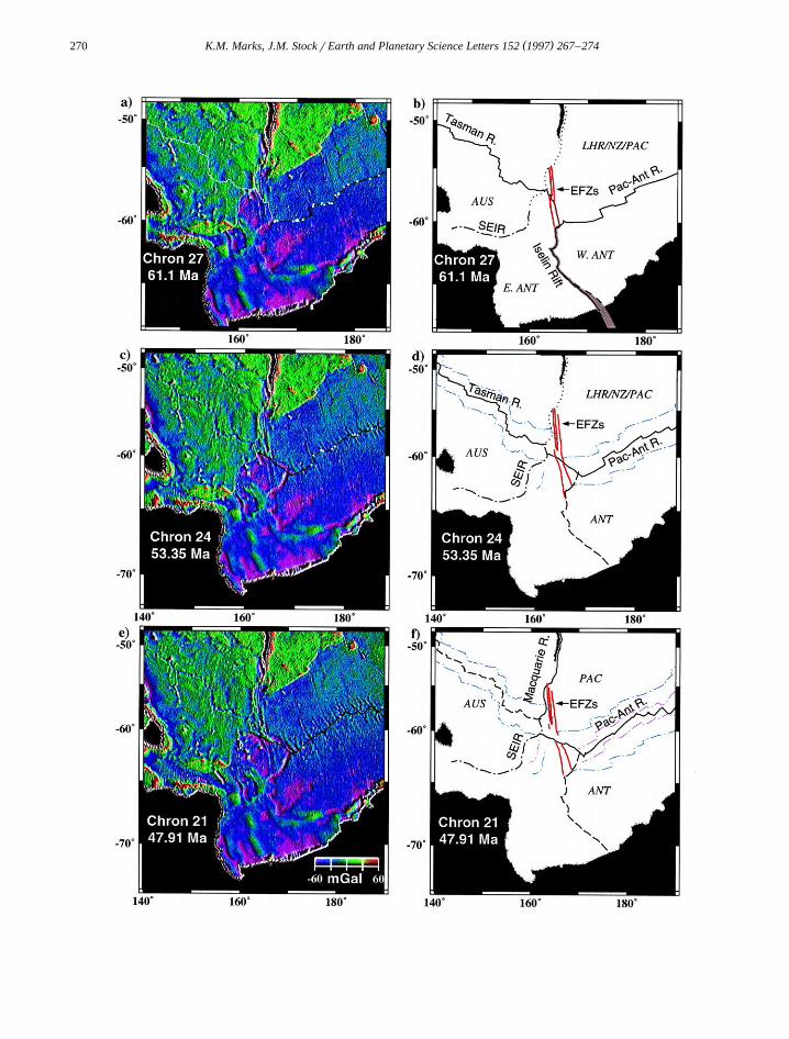
Our scenario for the opening of the Southwest
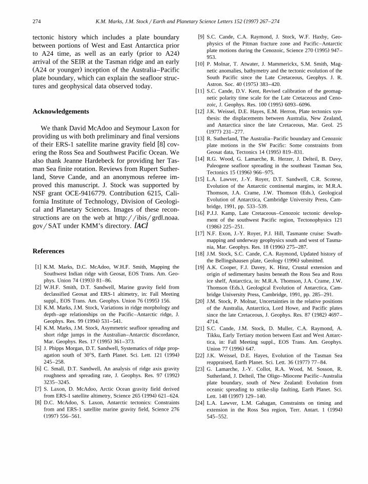
Ž .Fig. 3. Isochrons solid lines and present-day gravity anomaliesin the northwest Ross Sea. Chrons 20 and 24 are from Lawver and
w x w xGahagan 24 , and 27 and 30 are from Stock et al. 18 . Inside thedashed region lies East Antarctic seafloor from spreading on theTasman ridge prior to Chron 24.
Pacific in the early Tertiary can explain the present-day gravity anomalies and isochrons observed in the
Ž .northwest Ross Sea Fig. 3 . Chrons 20 and 24northwest of the Iselin Bank lie in seafloor formed
w xby early spreading on the SEIR. Cande et al. 21have tentatively identified anomalies as old as A27in this SEIR seafloor, which is consistent with ourconclusion that the SEIR reached the Tasman ridgeprior to Chron 24. We estimate that the transitionbetween SEIR and Tasman seafloor lies along thedashed boundary with question marks shown in Fig.3. Inside the dashed region lies East Antarcticseafloor generated on the Tasman ridge prior to A24w x21 . Traces of the East and West Emerald fracture
Ž .zones EFZs in Fig. 3 are embedded in this EastAntarctic seafloor. If our reconstructions are correct,then magnetic anomalies on East Antarctic seafloorŽ .inside the dashed region should have an east–westorientation, roughly parallel to the paleo-Tasman
Ž .ridge Fig. 2a . This is consistent with the strike ofw xmagnetic anomalies observed by Cande et al. 21 in
this area. Also, our reconstructions predict that mag-netic anomalies west of the East Emerald fracture
Žzone are older than C27, while on the east inside the. Ždashed region of Fig. 3 they are younger between
.C27 and C24 in age . Seafloor from spreading on thePacific–Antarctic ridge since at least Chron 30 lieseast of the dashed region.
3. Concluding remarks
We have used state-of-the-art marine gravity fieldsderived from ERS-1 and Geosat satellite altimeterdata in combination with magnetic anomalies identi-fied from ship surveys to reconstruct early Tertiarygravity fields over the Southwest Pacific. ThisSouthwest Pacific region has been the subject ofnumerous and often conflicting studies that haveattempted to construct the history of plate motionand plate boundary evolution as the Australia andPacific plates separated from Antarctica. These ma-rine gravity field reconstructions reveal much aboutconfiguration of the plate boundaries and the evolv-ing plate tectonics that existed in the SouthwestPacific during the early Tertiary, even though theexact details of how the boundaries around the triplejunctions have propagated and died out remains to besolved by ship surveys. Our reconstructions reveal a
( )K.M. Marks, J.M. StockrEarth and Planetary Science Letters 152 1997 267–274274
tectonic history which includes a plate boundarybetween portions of West and East Antarctica prior
Ž .to A24 time, as well as an early prior to A24arrival of the SEIR at the Tasman ridge and an earlyŽ .A24 or younger inception of the Australia–Pacificplate boundary, which can explain the seafloor struc-tures and geophysical data observed today.
Acknowledgements
We thank David McAdoo and Seymour Laxon forproviding us with both preliminary and final versions
w xof their ERS-1 satellite marine gravity field 8 cov-ering the Ross Sea and Southwest Pacific Ocean. Wealso thank Jeanne Hardebeck for providing her Tas-man Sea finite rotation. Reviews from Rupert Suther-land, Steve Cande, and an anonymous referee im-proved this manuscript. J. Stock was supported byNSF grant OCE-9416779. Contribution 6215, Cali-fornia Institute of Technology, Division of Geologi-cal and Planetary Sciences. Images of these recon-structions are on the web at http:rribisrgrdl.noaa.
[ ]govrSAT under KMM’s directory. AC
References
w x1 K.M. Marks, D.C. McAdoo, W.H.F. Smith, Mapping theSouthwest Indian ridge with Geosat, EOS Trans. Am. Geo-
Ž .phys. Union 74 1993 81–86.w x2 W.H.F. Smith, D.T. Sandwell, Marine gravity field from
declassified Geosat and ERS-1 altimetry, in: Fall MeetingŽ .suppl., EOS Trans. Am. Geophys. Union 76 1995 156.
w x3 K.M. Marks, J.M. Stock, Variations in ridge morphology anddepth–age relationships on the Pacific–Antarctic ridge, J.
Ž .Geophys. Res. 99 1994 531–541.w x4 K.M. Marks, J.M. Stock, Asymmetric seafloor spreading and
short ridge jumps in the Australian–Antarctic discordance,Ž .Mar. Geophys. Res. 17 1995 361–373.
w x5 J. Phipps Morgan, D.T. Sandwell, Systematics of ridge prop-Ž .agation south of 308S, Earth Planet. Sci. Lett. 121 1994
245–258.w x6 C. Small, D.T. Sandwell, An analysis of ridge axis gravity
Ž .roughness and spreading rate, J. Geophys. Res. 97 19923235–3245.
w x7 S. Laxon, D. McAdoo, Arctic Ocean gravity field derivedŽ .from ERS-1 satellite altimetry, Science 265 1994 621–624.
w x8 D.C. McAdoo, S. Laxon, Antarctic tectonics: Constraintsfrom and ERS-1 satellite marine gravity field, Science 276Ž .1997 556–561.
w x9 S.C. Cande, C.A. Raymond, J. Stock, W.F. Haxby, Geo-physics of the Pitman fracture zone and Pacific–Antarctic
Ž .plate motions during the Cenozoic, Science 270 1995 947–953.
w x10 P. Molnar, T. Atwater, J. Mammerickx, S.M. Smith, Mag-netic anomalies, bathymetry and the tectonic evolution of theSouth Pacific since the Late Cretaceous, Geophys. J. R.
Ž .Astron. Soc. 40 1975 383–420.w x11 S.C. Cande, D.V. Kent, Revised calibration of the geomag-
netic polarity time scale for the Late Cretaceous and Ceno-Ž .zoic, J. Geophys. Res. 100 1995 6093–6096.
w x12 J.K. Weissel, D.E. Hayes, E.M. Herron, Plate tectonics syn-thesis: the displacements between Australia, New Zealand,and Antarctica since the late Cretaceous, Mar. Geol. 25Ž .1977 231–277.
w x13 R. Sutherland, The Australia–Pacific boundary and Cenozoicplate motions in the SW Pacific: Some constraints from
Ž .Geosat data, Tectonics 14 1995 819–831.w x14 R.G. Wood, G. Lamarche, R. Herzer, J. Delteil, B. Davy,
Paleogene seafloor spreading in the southeast Tasman Sea,Ž .Tectonics 15 1996 966–975.
w x15 L.A. Lawver, J.-Y. Royer, D.T. Sandwell, C.R. Scotese,Evolution of the Antarctic continental margins, in: M.R.A.
Ž .Thomson, J.A. Crame, J.W. Thomson Eds. , GeologicalEvolution of Antarctica, Cambridge University Press, Cam-bridge, 1991, pp. 533–539.
w x16 P.J.J. Kamp, Late Cretaceous–Cenozoic tectonic develop-ment of the southwest Pacific region, Tectonophysics 121Ž .1986 225–251.
w x17 N.F. Exon, J.-Y. Royer, P.J. Hill, Tasmante cruise: Swath-mapping and underway geophysics south and west of Tasma-
Ž .nia, Mar. Geophys. Res. 18 1996 275–287.w x18 J.M. Stock, S.C. Cande, C.A. Raymond, Updated history of
Ž .the Bellingshausen plate, Geology 1996 submitted.w x19 A.K. Cooper, F.J. Davey, K. Hinz, Crustal extension and
origin of sedimentary basins beneath the Ross Sea and Rossice shelf, Antarctica, in: M.R.A. Thomson, J.A. Crame, J.W.
Ž .Thomson Eds. , Geological Evolution of Antarctica, Cam-bridge University Press, Cambridge, 1991, pp. 285–291.
w x20 J.M. Stock, P. Molnar, Uncertainties in the relative positionsof the Australia, Antarctica, Lord Howe, and Pacific plates
Ž .since the late Cretaceous, J. Geophys. Res. 87 1982 4697–4714.
w x21 S.C. Cande, J.M. Stock, D. Muller, C.A. Raymond, A.Tikku, Early Tertiary motion between East and West Antarc-tica, in: Fall Meeting suppl., EOS Trans. Am. Geophys.
Ž .Union 77 1996 647.w x22 J.K. Weissel, D.E. Hayes, Evolution of the Tasman Sea
Ž .reappraised, Earth Planet. Sci. Lett. 36 1977 77–84.w x23 G. Lamarche, J.-Y. Collot, R.A. Wood, M. Sosson, R.
Sutherland, J. Delteil, The Oligo–Miocene Pacific–Australiaplate boundary, south of New Zealand: Evolution fromoceanic spreading to strike-slip faulting, Earth Planet. Sci.
Ž .Lett. 148 1997 129–140.w x24 L.A. Lawver, L.M. Gahagan, Constraints on timing and
Ž .extension in the Ross Sea region, Terr. Antart. 1 1994545–552.