Embed Size (px)
Citation preview
Early basin insights and AVO supported leads from new long offset 2D seismic data,
Labrador Sea, Canada Richard Wright*, James Carter, and Deric Cameron, Nalcor Energy Oil and Gas
Tom Neugebauer, TGS
Jerry Witney, PGS
Daniel Hughes, Astrium Services
Summary
The first regionally extensive long offset 2D seismic
program has been acquired in the slope and deepwater
regions of the Labrador Sea, offshore Canada. The survey
was planned integrating well ties from the shelf, regional
gravity data, and newly acquired satellite slick data that
suggested the potential for oil prone hydrocarbon systems
in the previously unexplored deepwater areas. The early
data results from this initial 2011-2012 program (22,000
line km) are encouraging and have resulted in the
identification and delineation of new basins, play types, and
AVO supported leads.
Introduction
The Labrador shelf region of offshore Eastern Canada saw
significant exploration activity in the 1970’s and 1980’s.
During that period, over 20 wells were drilled on the
Labrador shelf resulting in 5 gas discoveries in the
Hopedale Basin totaling over 4 TCF of gas resources.
While there was significant exploration activity on the shelf
during this time, the exploration of the slope and deepwater
areas was very limited and no wells were drilled beyond the
shelf edge. As a result of the gas discoveries on the shelf,
the broader area was largely thought to be gas prone and
exploration became dormant after the 1980’s. To better
understand the potential for oil prone source rock presence
throughout the offshore area, Nalcor and Astrium Services
undertook a regional satellite oil slick mapping survey
covering all of Newfoundland and Labrador’s offshore area
(approximately 1.5 million square kilometers). This
satellite mapping survey located slick anomalies in areas of
known discoveries (Jeanne d’Arc Basin, Grand Banks) and
also imaged slicks in frontier areas of the offshore
including numerous anomalies in the Labrador Sea slope
and deepwater areas out beyond legacy seismic coverage.
The presence and location of the satellite slicks in the
Labrador Sea raised new questions. If the slick anomalies
were resulting from insitu migration, this suggested the
potential for the presence of a liquids prone source rock in
the slope and deepwater. Additionally, the location of
some of the seaward slicks further suggested the potential
for basins extending significantly further offshore than
previously understood.
To address these fundamental questions and delineate the
potential of the largely unexplored slope and deepwater
areas of the Labrador Sea, Nalcor Energy invested and
partnered with TGS and PGS in a new 2D long offset
GeoStreamer® seismic survey spanning the Canadian
Labrador Sea from the shelf edge to the Canada-Greenland
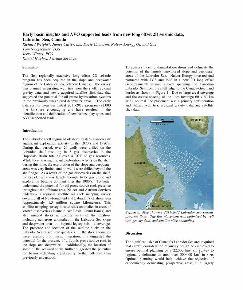
border as shown in Figure 1. Due to large areal coverage
and the coarse spacing of the lines (average 60 x 60 km
grid), optimal line placement was a primary consideration
and utilized well ties, regional gravity data, and satellite
slick data.
Figure 1. Map showing 2011-2012 Labrador Sea seismic
program lines. The line placement was optimized by well
ties, gravity data, and satellite slick anomalies.
Discussion
The significant size of Canada’s Labrador Sea area required
that careful consideration of survey design be employed to
ensure optimal planning of a 22,000 line km survey to
regionally delineate an area over 300,000 km2 in size.
Optimal planning would help achieve the objective of
economically delineating prospective areas in a largely
DOI http://dx.doi.org/10.1190/segam2013-1128.1© 2013 SEGSEG Houston 2013 Annual Meeting Page 4558
Dow
nloa
ded
09/0
3/13
to 2
10.8
7.52
.22.
Red
istr
ibut
ion
subj
ect t
o SE
G li
cens
e or
cop
yrig
ht; s
ee T
erm
s of
Use
at h
ttp://
libra
ry.s
eg.o
rg/
Early basin insights and AVO supported leads from new long offset 2D seismic data, Labrador
Sea, Canada
unexplored slope/deepwater region. The key
considerations for survey design were: (1) tying wells on
the shelf to extend the stratigraphic interpretation from the
known shelf to the unknown deepwater; (2) gravity
anomalies that could indicate the presence of sedimentary
basins; and (3) tying satellite identified oil slicks in the
slope/deepwater. The satellite slick data was screened and
processed for wind, wave, vessel traffic, natural film, and
ice conditions that existed during scene acquisition to
ensure that identified anomalies were consistent with
conditions that could yield insitu related oil expressions on
the sea surface. In offshore eastern Canada, the vast
majority of satellite data is disqualified for slick detection
through this process - largely based on unsuitable wind and
wave conditions. While this results in the removal of the
majority of anomalies from consideration, the remaining
slick anomalies that can not be disqualified for these and
other factors could be related to insitu oil migration to the
ocean surface. While this process enhances confidence in
the results, we additionally calibrated the slick data to areas
of known oil discoveries in the Jeanne d’Arc basin to the
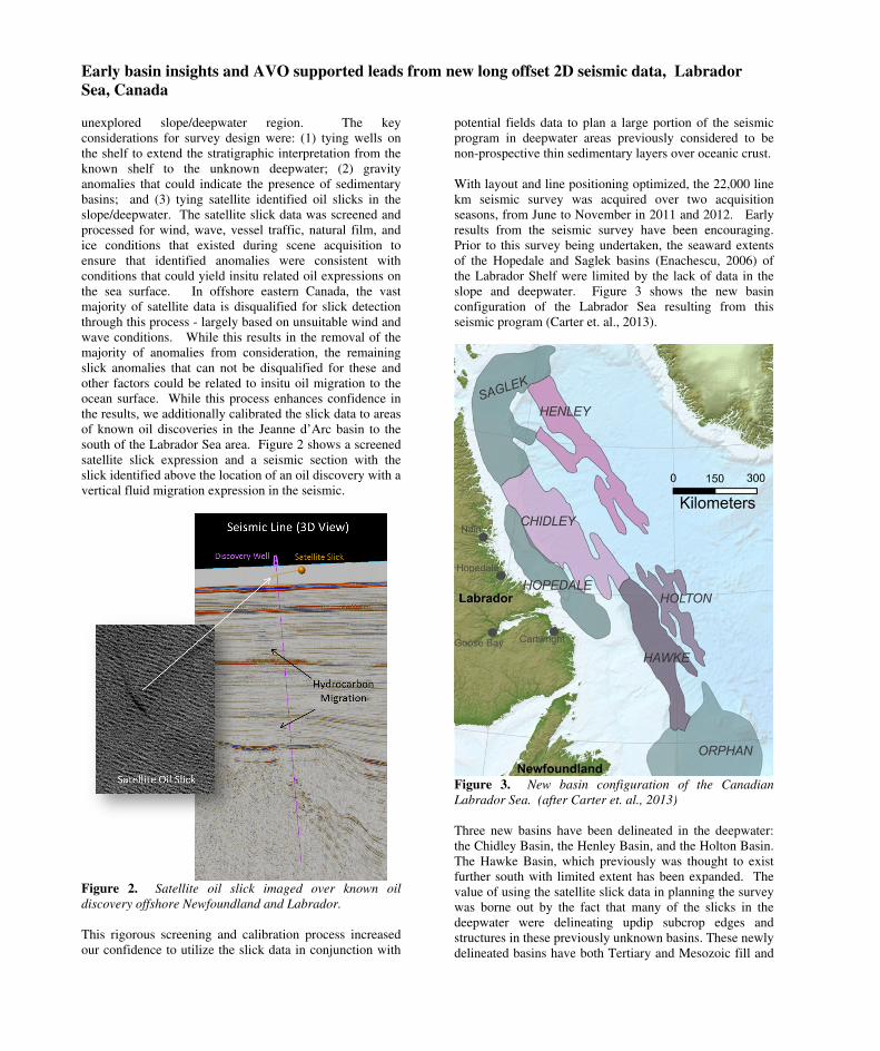
south of the Labrador Sea area. Figure 2 shows a screened
satellite slick expression and a seismic section with the
slick identified above the location of an oil discovery with a
vertical fluid migration expression in the seismic.
Figure 2. Satellite oil slick imaged over known oil
discovery offshore Newfoundland and Labrador.
This rigorous screening and calibration process increased
our confidence to utilize the slick data in conjunction with
potential fields data to plan a large portion of the seismic
program in deepwater areas previously considered to be
non-prospective thin sedimentary layers over oceanic crust.
With layout and line positioning optimized, the 22,000 line
km seismic survey was acquired over two acquisition
seasons, from June to November in 2011 and 2012. Early
results from the seismic survey have been encouraging.
Prior to this survey being undertaken, the seaward extents
of the Hopedale and Saglek basins (Enachescu, 2006) of
the Labrador Shelf were limited by the lack of data in the
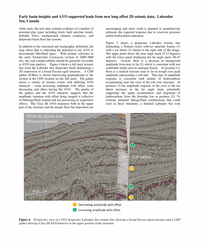
slope and deepwater. Figure 3 shows the new basin
configuration of the Labrador Sea resulting from this
seismic program (Carter et. al., 2013).
Figure 3. New basin configuration of the Canadian
Labrador Sea. (after Carter et. al., 2013)
Three new basins have been delineated in the deepwater:
the Chidley Basin, the Henley Basin, and the Holton Basin.
The Hawke Basin, which previously was thought to exist
further south with limited extent has been expanded. The
value of using the satellite slick data in planning the survey
was borne out by the fact that many of the slicks in the
deepwater were delineating updip subcrop edges and
structures in these previously unknown basins. These newly
delineated basins have both Tertiary and Mesozoic fill and
DOI http://dx.doi.org/10.1190/segam2013-1128.1© 2013 SEGSEG Houston 2013 Annual Meeting Page 4559
Dow
nloa
ded
09/0
3/13
to 2
10.8
7.52
.22.
Red
istr
ibut
ion
subj
ect t
o SE
G li
cens
e or
cop
yrig
ht; s
ee T
erm
s of
Use
at h
ttp://
libra
ry.s
eg.o
rg/
Early basin insights and AVO supported leads from new long offset 2D seismic data, Labrador
Sea, Canada
while early, the new data contains evidence of a number of
potential play types including listric fault anticline trends,
turbidite flows, amalgamated channel complexes, and
deepwater basin floor fan systems.
In addition to the structural and stratigraphic definition, the
long offset data is indicating the potential to use AVO to
discriminate litho/fluid types. With seismic velocities in
the early Tertiary/late Cretaceous section of 2000-3000
m/s, the rock compressibility should be generally favorable
to AVO type analysis . Figure 4 shows a full stack seismic
line from the Labrador Sea deepwater basin delineating a
2D expression of a broad Eocene aged structure. A CDP
gather (0-8km) is shown intersecting perpendicular to the
section at the CDP location on the full stack. The gather
shows a variety of seismic events with differing AVO
character – some increasing amplitude with offset, some
decreasing, and others having flat AVO. The quality of
the gathers and the AVO character suggests that the
amplitude variation with offset being imaged is reflective
of lithology/fluid content and not processing or acquisition
effects. The Class III AVO responses both in the upper
part of the structure and the deeper floor fan deposition are
encouraging and more work is planned to quantitatively
delineate the expected response due to reservoir presence
and/or hydrocarbon saturation.
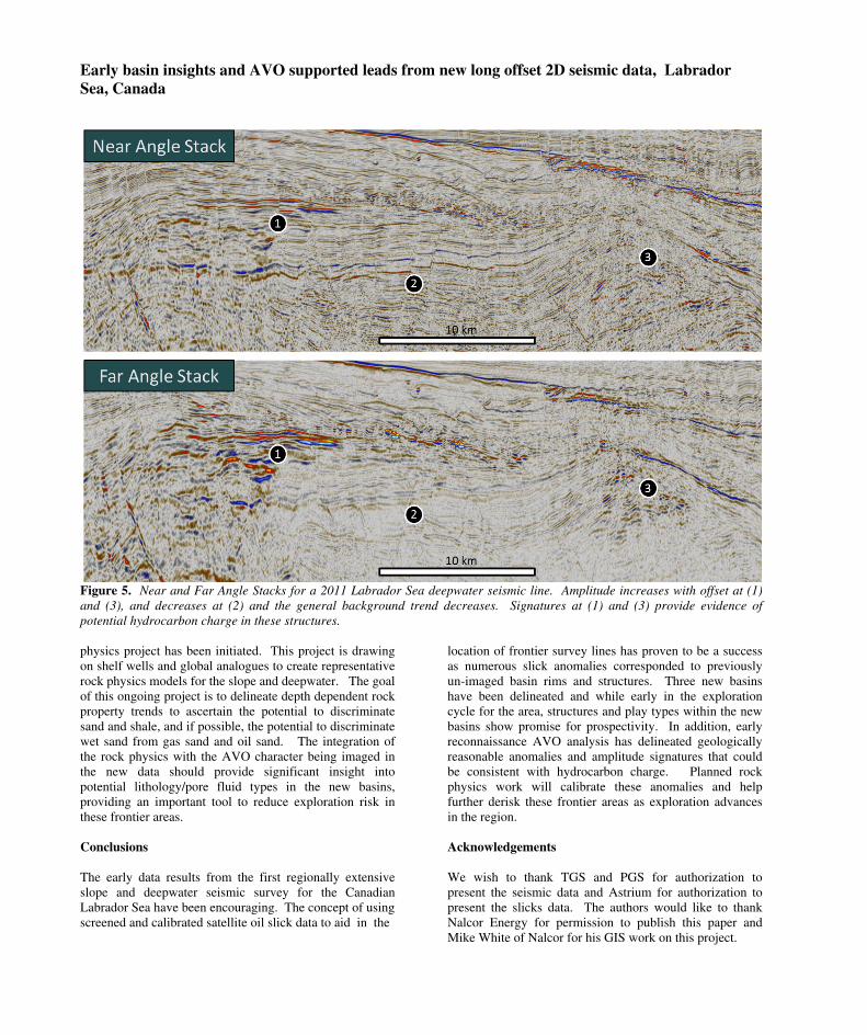
Figure 5 shows a deepwater Labrador seismic line
delineating a Tertiary listric rollover anticline feature (1)
with a toe thrust (3) shown to the right side of the image.
The upper panel shows the near angle stack (5-12 degrees)
with the lower panel displaying the far angle stack (40-47
degrees). Overall, there is a decrease in background
amplitude from near to far (2) which is consistent with wet
sand/shale trends seen in analogue basins. At position (1),
there is a marked increase near to far in trough over peak
amplitude representing a soft unit. This type of amplitude
response is consistent with models of hydrocarbons
accumulating near the crest of the roll over structure. At
position (3) the amplitude response of the crest of the toe
thrust increases in the far angle stack, potentially
suggesting the updip accumulation and migration of
hydrocarbons from the downdip low at position (2). To
estimate potential lithogy/fluid combinations that could
exist in these structures, a detailed Labrador Sea rock
Figure 4. Perspective view of a 2012 deepwater Labrador Sea seismic line showing a broad Eocene aged structure and a CDP
gather showing Class III AVO behavior in the upper portion of the structure.
DOI http://dx.doi.org/10.1190/segam2013-1128.1© 2013 SEGSEG Houston 2013 Annual Meeting Page 4560
Dow
nloa
ded
09/0
3/13
to 2
10.8
7.52
.22.
Red
istr
ibut
ion
subj
ect t
o SE
G li
cens
e or
cop
yrig
ht; s
ee T
erm
s of
Use
at h
ttp://
libra
ry.s
eg.o
rg/
Early basin insights and AVO supported leads from new long offset 2D seismic data, Labrador
Sea, Canada
Figure 5. Near and Far Angle Stacks for a 2011 Labrador Sea deepwater seismic line. Amplitude increases with offset at (1)
and (3), and decreases at (2) and the general background trend decreases. Signatures at (1) and (3) provide evidence of
potential hydrocarbon charge in these structures.
physics project has been initiated. This project is drawing
on shelf wells and global analogues to create representative
rock physics models for the slope and deepwater. The goal
of this ongoing project is to delineate depth dependent rock
property trends to ascertain the potential to discriminate
sand and shale, and if possible, the potential to discriminate
wet sand from gas sand and oil sand. The integration of
the rock physics with the AVO character being imaged in
the new data should provide significant insight into
potential lithology/pore fluid types in the new basins,
providing an important tool to reduce exploration risk in
these frontier areas.
Conclusions
The early data results from the first regionally extensive
slope and deepwater seismic survey for the Canadian
Labrador Sea have been encouraging. The concept of using
screened and calibrated satellite oil slick data to aid in the
location of frontier survey lines has proven to be a success
as numerous slick anomalies corresponded to previously
un-imaged basin rims and structures. Three new basins
have been delineated and while early in the exploration
cycle for the area, structures and play types within the new
basins show promise for prospectivity. In addition, early
reconnaissance AVO analysis has delineated geologically
reasonable anomalies and amplitude signatures that could
be consistent with hydrocarbon charge. Planned rock
physics work will calibrate these anomalies and help
further derisk these frontier areas as exploration advances
in the region.
Acknowledgements
We wish to thank TGS and PGS for authorization to
present the seismic data and Astrium for authorization to
present the slicks data. The authors would like to thank
Nalcor Energy for permission to publish this paper and
Mike White of Nalcor for his GIS work on this project.
DOI http://dx.doi.org/10.1190/segam2013-1128.1© 2013 SEGSEG Houston 2013 Annual Meeting Page 4561
Dow
nloa
ded
09/0
3/13
to 2
10.8
7.52
.22.
Red
istr
ibut
ion
subj
ect t
o SE
G li
cens
e or
cop
yrig
ht; s
ee T
erm
s of
Use
at h
ttp://
libra
ry.s
eg.o
rg/
http://dx.doi.org/10.1190/segam2013-1128.1 EDITED REFERENCES Note: This reference list is a copy-edited version of the reference list submitted by the author. Reference lists for the 2013 SEG Technical Program Expanded Abstracts have been copy edited so that references provided with the online metadata for each paper will achieve a high degree of linking to cited sources that appear on the Web. REFERENCES
Carter, J. E., D. E. Cameron, R. Wright, and E. Gillis , 2013, New insights on the slope and deep water region of the Labrador Sea, Canada: Presented at the 75th Annual International Conference and Exhibition, EAGE.
Clark, V. A., 1992, The effect of oil under in-situ conditions on the seismic properties of rocks: Geophysics, 57, 894–901.
Enachescu, M., 2006, Hopedale Basin-1, Atlantic off Labrador poised for modern exploration round: Oil & Gas Journal, 104, no. 23, 29–34.
Wang, Z., 2001, Fundamentals of seismic rock physics: Geophysics, 66, 398–412.
DOI http://dx.doi.org/10.1190/segam2013-1128.1© 2013 SEGSEG Houston 2013 Annual Meeting Page 4562
Dow
nloa
ded
09/0
3/13
to 2
10.8
7.52
.22.
Red
istr
ibut
ion
subj
ect t
o SE
G li
cens
e or
cop
yrig
ht; s
ee T
erm
s of
Use
at h
ttp://
libra
ry.s
eg.o
rg/


![[Castagna J.P.] AVO Course Notes, Part 3. Poor AVO](https://img.pdfslide.us/doc/110x75/563db964550346aa9a9ce6c7/castagna-jp-avo-course-notes-part-3-poor-avo.jpg)