Embed Size (px)
Citation preview
COMMONWEALTH OF AUSTRALIA
DEPARTMENT OF NATIONAL DEVELOPMENT
BUREAU OF MINERAL RESOURCES,GEOLOGY AND GEOPHYSICS
RECORDS:
1964/128
REPORT ON GEOCHEMICAL PROSPECTING PROGRAMME AT MOUNT ISA 1963.
'by
D.O. Zimmerman
The information contained in this report has been obtained by theDepartment of National Development, as part of the policy of the Common-wealth Government, to assist in the exploration and development of mineralresources. It may not be published in any form or used in a companyprospectus without the permission in writing of the Director, Bureau ofMineral Resources, Geology and Geophysics.
REPORT ON GEOCHEMICAL PROSPECTING PROGRAMME AT MOUNT-'ISA .1·96:3.
by
D.O. Zimmerman.
RECORDS 1964/128
SUMMARY
INTRODUCTION situ,;.tlon ~neral Geology Detailed Geology Mineralization
CONTENTS
Theories of Ore Genesis and their Relation to the Geochemical Programme
AIMS OF THE INVESTIGATION SAlVIPLING METHODS
Orientation Sampling Auger Sampling Diamond Drill Core Sampling
SAMPLING PROGRAMME Detailed Samples
!al Northern Leases b Mine Area c Dawn Area
General Sampling Diamond Drill Holes Progress in Sampling
RESULTS OF ORIENTATION WORK . ANALYTICAL METHODS SUGGESTED TREATMENT OF RESULTS
Halo Study Stratigraphic ,~tudy
," ACKNOWLEDGEMENTS
Page
1
2
2 2 2 3
4 5 6
6 6 6
7 7 7 7 7 8 8 9 9
10
10 10 12 13
The information contained in this report has been obtained by the Department of National Development, as part of tbe policy of the Commonwealth Government, to assist in the exploration and development of mineral resources.: It may not be published in any form or used in a company prospectus without the permission in writing of the Director, Bureau of Mineral Resources, Geology and Geophysios. \
--"
(11)
TABLES
1. Summary of Drill Hole Sampling Mount Isa GeochemiQ.&ll.Programme.
2. Suggested layout of computer ratio-readout for visual inspection and comparison.
FIGURES
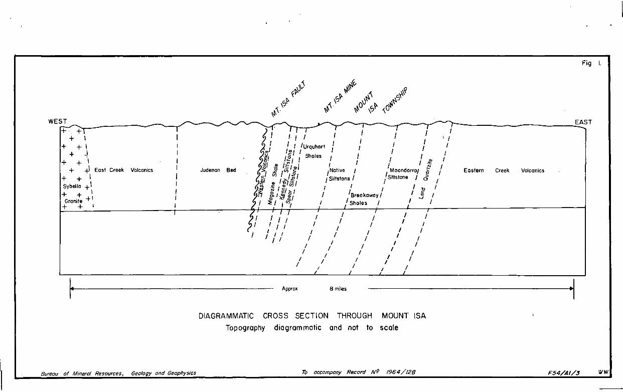
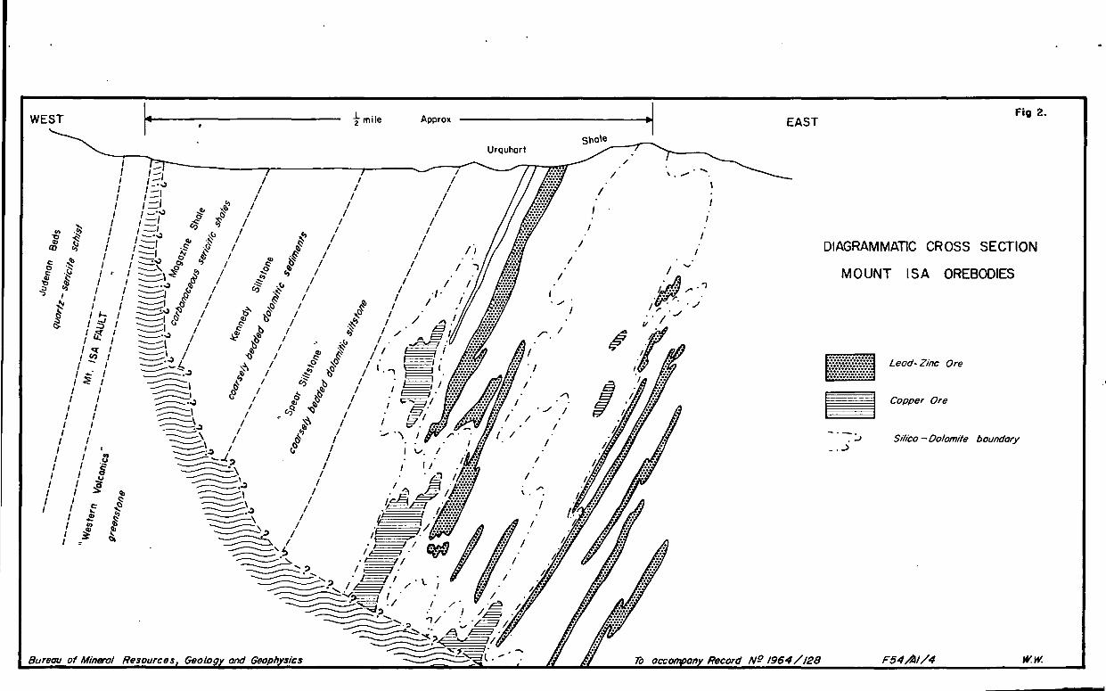
1. Diagrammatic cross section through Mount Isa.
2. Diagrarcmatic cross section showing Mount Isa ore bedies and underlying greenstone.
PLATES
1. Geological Map, Mount Isa Mines Lease, showing covered by geochemical sampling.
2. Sketch Map, Northern Leases Area, Mount Isa, showing Geochemical Grid.
3. Map of Dawn and Bernborough areas, Mount Isa, showing Geochemical Grid.
4. Map sao'A'ing rolationsaips botwoon U/G dPill aore samplea and oro minorali~atiQn.
REPORT ON GEOCHmUCAL PROSPECTING PROGRAMME AT MOUNT ISA 1963
by
D.O. Zimmerman
SUMMARY
In 1963 the Bureau of rUneral Resources in cooperation with MOUnt:lsa Mines Ltd commenced ~ progr~e of geochemical prospecting studies, in:.the vicinity of :p1ineralization at Mount Isa. In this report the geology ~nd mineralization of the Mount Isa district is discussed, ,th~ aims of the geochemice..l investigation are" set out, and, geological factors relating to the geochemical study are considered. The areas sampled aFd the sampling methods" employed {3.t Mount Isa ~.re described) the results 'of ·the,orie,ntati9~ sampling anq. implica tions are given. ' . I
During the 1963 field season 2338 samples of soil, rock, diamond drill core' and auger, drill cutttngs were ' collected, f'rom the vicinity ot the Moun.t Tsa lead-zinc and copper -ore bodiesi The resul,ts,:of the. orie~tation sampling show that 36, ,elements. ,are detectable by.spec,trographic analysis in samples of Urquhart Shale.in, .th~"Upm..e(liate -' vicinity of mineralization.
The results also showed that there is no significant enrichment in·tr'ace-element content for 20 ft ,below weathered bedrock surface. Consequently it is not- nec,es'sary to sample deeper than four feet· into weathered rO,ck, i._e~, sufficiently deep to .avoid surfac'e .contamination. ; Analy~es.of the ~ount Isa weathered rock (auger)· and ',drill core sampl~s has not yet begun but a suggested, ,·treatment :Qf thereBul ts is outlined.
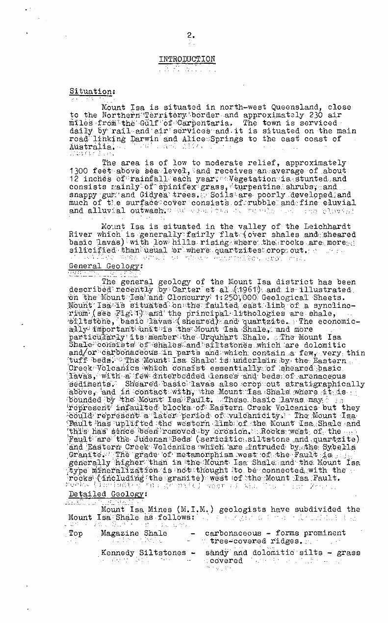
2.
INTRODUCTION
Situation: ...
Mount Isa is situated in north-west Queensland, close 1;0 the Northern·'l,Terri t0r-y ',border ,andapproximatoly 230 air ID:i:les ·frdm·t,the' . Gulf ,'of, :Carpehtaria. Th\3 town is serviced· da~ly by' railarid'airi'services"and,it is situated on the main road: ;Lihking Darwin' and Alice :;Springs to the eastl coast of 1i.ustraiia~ " ,',,; ,\:< ".:.;.', . , . . .. ~ :; I :.' :: .:.
The area is of low to moderate relief, approximately 1300 :r:e·~t'·abdve sea'. level, i.: and receives 'an,.: average of .abou~ 12 'incnes oI(:raiilfall,'each y.ear~·'·(:Vegetation··is,cs,tunte.d.-,and consists J1.~.a:lnly··: of" spini·fex gr'ass, \'·tgrpeilt·ine: shruhs·,·.: an9. ... snappy gut:" and Gidyea: trees. ;: .... Soils~· ar~· pbbrly,:d·e:ve19P.ed~ and much of tJ.e surface'.'cov'er· consists. of::rubble:and~'firte; eluvial a'nd alluv~~al ou. twa,:sh~ ,~). ':.1' ',' ,} • ':' :, .-i" :.~ •. ::.:' : ':::, C' l.·, :'~l";','}
rv:o~Lnt Isa is situated in the valley of the Leichhardt River which' is:generalily: fa:irly flat\':~bver .shales .andr:::shea):'ed basic ':lava':s):, with ·l'ow·~ hills.:r'ising,. where~ .. the~ !rbc.ksare:·. m0re~; t~ s~ B:c~l~ed:' ;than;:usua:l :crr·l
. Wher'€!: . qrGI:art'zi:t'e s;~ :crop::;out .: '.' . I ~ .' ~'l'~'.::_'~!': ',J;":.L".: ., I ,' .... , ';'~" ~\; ", . ;'() ....... ~) 't I.,
General Geologx: ' .. l:.',:_:~'_·.:~~·'. : ... __ ._:": .. ~' :' :" '--:.~' .'
The general geology of the Mount Isa district has been ciescribeci': r:ec'entiy ,'by: ·Car.~ter' et ::al·::~',1:96t)".and .. i·s' illustrat.ed. '0'.n· ~~he"'lVlbunt-Jlsa) :and,' C}on8urry~" 1': 25bV000) Ge.01ogicalSheets. ~1YIouh,t" :rsa,<Ts s'ituat-ecf:bnJ:-the:fault'ed, :.east.:,liinQ 'c'fa synclino~r.i'UiIi; ,Cs'ee ~;Flg~~,1')'··::.ahdi the prinfcipa-l:o :1tthoQ..ogd:es 'are' shale,. '. 'sl:,ltstohe, .'.basiC ;];"8.V8.'8« shea:re-d,Y<aridi ~quarrl:;z1.t'eo, " The economic-;a~.ly'.:.i i:iIiportan·ti. (und:'t J;i's ;the"~;Mounit 7Isa ·.Shal·e:,·~'and more . par.ti'c\:{::tarly! its !m'ember::~the·,· Ur'q'uh~~t :Shalle..:,The: 'Mount I sa Sha'le':'coii"s:i:stsL 'bf~;'::shales::':and),!siJlts,t'ortes<which :aredolonii tic and/or·:'car:b'bnac·eous.fri ·.par.tsand:twhich' con:tain.ia' few,very: thin I-tuff· ~bE(as·~; 'G ~ThEf(MbUrt.t·: ]sa: ;ShaJre~ ts, )ur1:derlaJin. :by, the'.' Eastern ... 'Creek"Vo}cariI-cs :'whichdons:l!st:- eSlsent·ialTy:·.~of :E?,he:ax.ed· :,pa;sic .. (Tav:i:l;s, ,,,lith' ·'a~ :few: ~irite:rbed:de~a ~lense~si :'an'<t be:ds··,:of.:·arenac.e:ous :sediinent·Ef.:;Sh!ear~d;:basic>lava::s ~also .':crop·out :s,trat.igraph:Lcally ::abb-ve, .. '!and .i-rl.·.cdhtact.viftth{"'theMount.·'Tsa (Shale'.':wher~: .:;i:i;-::i:s, : .. ;bourided~·"by ·'-the: lMo'u.:n;t~ Isa!;'Fault.'. ,."The~se:: .:bastc ~lavas.may~. ::: .; :'; . i.rcpreserlAi ,i~ri!au.lted'b:locks .. ;O:f;;.Ea~itern: C~e.ek V,olcani:G~' but they ::,co1ild);represen?t:'a:;~ater:·per·i:od'·of!:.~vu16an~ic:i t·Y·,.l ' The:'~Jlbu,nt ·Js_a· ':])au1:t .lhas'upl:i;ft·ed<the we'st:ern dimb.':'o.f."the' 'Mount'I:sa . .:Sha::le: ,and I,'t~lls: . 1:1a's-' ~~:ric e-- tl:5"9B rr~ r'embVe a ',by:e:r.'cYs i o'h. '.:'~ :,R o'ck s-; "WEi:s:t Qt\·· t.he .. :' :' ··Fa1;l:1 t' "arc'; the- Jude nan i;]3e''ds: (.ser.ic,i.tic·! ,sirt-s-tone, .. and .. q,ua:r·t:zi te) "and~Eas'ter'nJ Gr,eek' Volcani'cs ,'whiich ~are ~intruded· by}(.!tne;Syq~}l.a; . Gr~,~te~ .. l·.'~he· grad'e"of'nie-ta.mor.phism ~west :·of~·.~the!:'Fa1J:l:t ::~·S) ,'.,J ;.~ . g'en'era:~lylh'igher~"~hari' i'n 1the::'M6unt, I.sa- ·.Shale;>and"tnG. M.ount Isa
·[;type ni·j!·rie:t'8;lyza't±0'n.'is i116tt :tnought Ito. be··.c.onnecte.d\,wi th -the: "r'6~ksl,{iri'qlud,f~ng :"~h~ :.gran·,f teJ,·: we;stl.of >the,:·Mount. ~-Isa :Fault. j·~_\I·li·.'.:; (\ J ::"! :1(~·!.;' '.' ~'r;; ::;r' "~'». i (~) 'J·/:":~=.T i .. ; "f, { ' •• ~ . ',' •. ' ./, ••
Detailed Geology: .... ' ~. ,., ,. \.: ,.-'. ~ : .'.' ... .. . ---"-....... Mounf"Isa Mines (M. LM.) geologists have subdivided the' Mount tsa . "Shale as ·foli6ws:" .':. <; " .. .', . " ....
. , .:... -- . ~ .
Top Magazine Shale carbonaceous - forms prominent .. :. '.;-" ' .. tree,;,;;cov,e,r,ea r·idges.:·.
,Kennedy . Siltstones - ~and.Y· and' dolo'mi tic . silts - grass : .'~' ': <.co'.vered
'.I,. ;".
WEST +- +
+ , + +1
+ ,I + + I
+ ~ East Creek
+ + I
I Sybelia +1 + + \
Granite + \ + + I
r
Volcanics
I I I I I I I I
Bureau of Mineral Resources, Geology and Geophysics
Fig I.
~ ____ -,--~ ________________ --________ ~E~AST
I I I } I I I I I I I I I , I 1!I1 I I I I :f:: /
,Native i Moondarral -g I I Siltstone I / Siltstone I & I
I I I ''tJ I I 'Breakaway / I ~ I
, I -J / Sholes /
Judenan Bed Eastern Creek Volcanics
fl I I / I I / ,
/ ! , I I I
I I I I I I I
I I I I
I '/1 / /
I I 1 I I I I / I I I
I I / I I I I
/ / I I I
I / /
Approx 8 miles ·1 DIAGRAMMATIC CROSS SECTION THROUGH MOUNT ISA
Topography diagrammatic and not to scale
To accompany Record Ng 1954/12B F54/AI/3 I.VW

Spear Siltstones
Urquhart Shale
Native Bee Siltstone
3.
- dolomitic siltstone - gra~e covered
- thin bedded pyritic and/or dolomitic shales and siltstones including some potash-rich tuff beds.
Breakaway Shale Moondarra Siltstone -
partly dolomitic silts essentially carbonaceous dolomitic and non-dolomitic silts.
The detailed geology of the Mount Isa Shale is illustrated in Plate I. It consists essentially of northsouth striking sediments, through which blocks of Eastern Creek Volcanics have been upfaulted. Mapping has not yet disclosed the Urquhart Shales south of the Crystallena Fault. Strike fati.l ting is fairly co.m.mon and such faults are commonly represent(;d by prominent quartz veins or ridges of silicified and/or iron-rich rocks. These features are well represented in the !viount Novi t area. Prominent ridges occur at r[ount Isa and Northern Leases because of the presence of silica-rich gossans and, in the former locality, jasper breccias. The jasper breccias may represent the sUrface expression of the "silica-dolomite" bodies which contain the copper mineralization at Mount Isa.
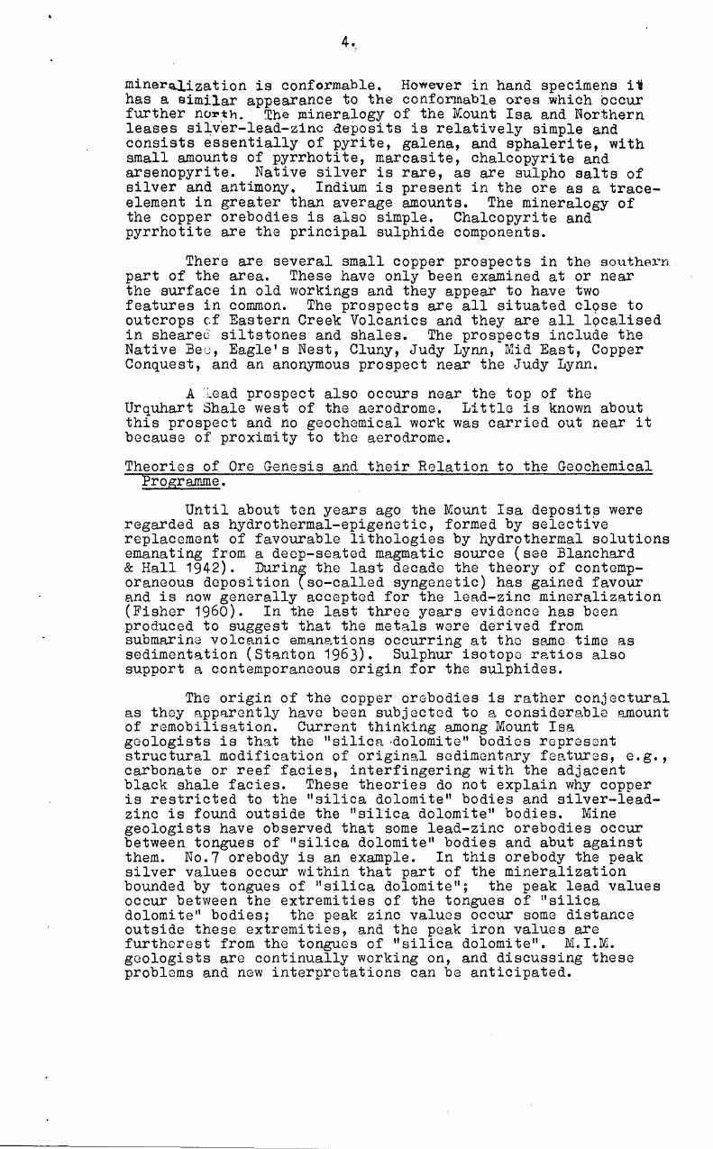
The subsurface geology at Mount Isa Mine is illustrated in Fig.2. The most significant features are the irregularly shaped "silica-dolomite" bodies and the underlying greenstones (basic lavas - possible equivalent to, or a part of, the Eastern Creek Volcanics). "Silica-dolomite" bodies are deformed areas of a particular type which provide the host for copper mineralization at Mount Isa. The term is purely an exploration concept. There are four fundamental lithologies, which make up "silica-dolomite" bodies; these are fractured, silicified fine-grained shale t dolomitised sh.ale (recrystallised dolomite along bedding planes), crystalline dolomite, and a type called "irreg. lI which is an irregular mixture of fractured silicified shale and dolomitised shale. Gradations between all four lithologies have been observed. The tlsilica-dolomite" bodies are generally slightly transgressive across the shales although conformable relationships are sometimes observed. In some localities coarsely crystalline dolomite is "intruded" between bedding planes of shales and it has forced the shales apart, in some instances for distances of more than 10 feet. Fragments of shale have been found in the intrusive coarsely crystalline dolomite. Recent work by M.l.M. geologists shows that "silica-dolomite" bodies generally become wider in depth and they commonly have a basal contact with greonstone. Mineralization:
As mentioned above, copper mineralization is intimately associated with silica-dolomite bodies, which are known to outcrop only in a few places in the Mine area.
The silver-lead-zinc mineralization occurs in conformable bodies in the Urquhart Shale at IvIount Isa (including the Bernborough and Leichhardt King prospects), Northern Leases, and at the Copalot Mine in the Mount Novit area. In the Mount Novit area the sediments are intensoly sheared and it is difficult to see whether or not the
tmile Fig 2. ~I WEST Approx
sno1e - ......... ~ ...... Urquhort
EAST
/
/
I
I DIAGRAMMATIC CROSS SECTION I
I MOUNT I S A OREBODIES
0./
r / tfJ Lead· Zinc Ore
a /\ B I
0/ I f1 !.
Copper Ore
I
/ S,Wca - Dolomite boundary
I
I o ""
\ 0 0
/
Bureau of Mineral Resources Geology and Geoph 'SIcs To ace any Record N9 1964/ 12B F54/A1/4 w.w.
4 •..
mineraJ.ization is conformable. However in hand specimens i~ has a similar appearance to the conformab~e ores which occur further noxoth. The mineralogy of the M:ount Isa and Northern leases si~v'er-Iead-z1ncde:posits is relatively simple and consists essentially of pyrite, galena, and sphalerite, with small amounts of pyrrhotite, marcasite, chalcopyrite and arsenopyrite. Native silver is rare, as are sulpho salts of silver and antimony. Indium is present in the ore as a traceelement in greater than average amounts. The mineralogy of the copper orebodies is also simple. Chalcopyrite and pyrrhotite are the principal sulphide components.
There are several small copper prospects in the southeX"rl part of the area. These have only been examined at or near the surface in old workings and they appear to have two features in common. The prospects are all situated cl9se to outcrops cf Eastern Creek Volcanics and they are all localised in sheareJ siltstones and shales. The prospects include the Native Be,,;, Eagle I s Nest, Cluny, Judy Lynn, Mid East, Copper Conquest, and an anonymous prospect near the Judy Lynn.
A :;.ead prospect also occurs near the top of the Urquhart Shale west of the aerodrome. Little is known about this prospect and no geochemical work was carried out near it because of proximity to the aerodrome.
Theories of Ore Genesis and their Relation to the Geochemical Programme.
Until about ten years ago the Mount Isa deposits were regarded as hydrothermal-epigenetic, formed by selective replacement of favourable lithologies by hydrothermal solutions emanating from a deep-seated magmatic source (see Blanchard & Hall 1942). Durin~ the last decade the theory of contemporaneous deposition tso-called syngenetic) has gained favour and is now generally accepted for the lead-zinc mineralization (Fisher 1960). In the last three years evidence has been produced to suggest that the metals were derived from submarine volcanic emane.tions occurring at tho sema time as sedimentation (Stanton 1963). Sulphur isotope ratios also support a contemporaneous origin for the sulphides.
The origin of the copper orobodies is rathor conjectural as they apparently have been subjected to a considerable amount of remobilisation. Current thinking among Mount Isa geologists is that the "silica ·dolomite" bodies represent structural modification of original sedimentary features, e.g., carbonate or reef facies, interfingering with the adjacent black shale facies. These theories do not explain why copper is restricted to the "silica dolomite" bodies and silver-Ieadzinc is found outside the "silica dolomite" bodies. Mine geologists have observed that some lead-zinc orebodies occur between tongues of "silica dolomite" bodies and abut against them. No.7 orebody is an example. In this orebody the peak silver values occur within that part of the mineralization bounded by tongues of IIsilica dolomite"; the peak lead values occur between the extremities of the tongues of II s ilica dolomite" bodies; the peak zinc values occur some distance outside these extremities, and the peak iron values are furtherest from the tongues of II silica dolomi te". M. LM. geologists are continually working on, and discussing these problems and new interpretations can be antiCipated.
The close association,0f copper mineralization with shQlU'ed basic rocks in the Mri')nt T9f1 area, and in fact in the whole l;,l.-,nr.l1x·i-y-Mount Isa. field, suggests that the copper ores may be derived by a. process of "sweating-out" from the basic rocks.
If the sulphides at Mount Isa were deposited contemporaneously with the sediments, one might expect very little geochemical disperson (primary dispersion) in the wall rocks of the orebodies. However there is abundant evidence that the sulphides at Mount Isa have 'i?een "remobilized" in some way; this evidence includes recrystallised sulphides, metamorphic ore textures, replacement textures, sulphide veining, and intrusive relationships of "silica dolomite" bodies containing chalcopyrite and pyrrhotite. It is to be hoped that, during the metamorphism of the sulphide-bearing rocks, some dispersion of trace elements will have occurred, probably by a process of solid dif~~·usion. This could give rise to primary dispersion haloes ar l ·und orebodies.
The greatest evidence of reconstitution occurs in the "silica dDlomite" bodies. In these it is common to find increasing amounts of pyrrhotite as one approaches an ore zone; consequently trace-element haloes may also be expected. In contrast visible evidence of proximity to bedded lead-zinc mineralization is much less apparent, and trace-element haloes around these bodies may be much narrower and more subtle. However, as the lead-zinc orebodies are generally conformable, it is reasonable to expect that abnormal trace-clement concentrations may occur in the mineralized stratigraphic horizons at some distance from the orebodies, and possibly beyond visible evidence of mineralization. This would tend to make trace-element haloes narrow, and a close sampling interval may be necessary to detect them in unweathered rocks.
In the near surface weathered rocks haloes around mineralization should be widespread because of the action of groundwater (secondary dispersion).
This discussion does not take into account the fact that many of the Mount Isa orebodies appear to be arranged en echelon along north-west south-east axes.
AIMS OF THE INVESTIGATION
The principal aim of the geochemical programme at Mount Isa is to determine whether or not significant trace element haloes exist around the copper, and silver-Iead-zinc orebodies at, or near, Mount Isa. The search for geochemical haloes will be conducted in the near-surface oxidised rocks and in diamond drill cores in the primary zone in the ratio of 2:1.
Several subsidiary projects arise out of the investigation. Firstly the trace-clement assemblages of the various stratigraphic units within the Mount Isa Shale will be studied to determine whether or not they show any diagnostic relationship to the mineralization. Secondly an attempt will be made to recognise the Urquhart Shale in the southern portion of the area on the basis of trace-element content. As yet surface mapping has failed to define this unit in the southern part of the area. Thirdly, the effect of cross-faulting on the trace-element content of the sediments will be studied.
~. (
In areas where mineralization is known, the analytical data will be examined for patterns which can be related to the mineralization~ E1sewhere the results will be examined for patterns and these wi~l '\)0 evaluated on the bEtsis of known information and comparison with datr.. over lrnown mincrnlizat1on.
SAMPLING METHODS
Orientation Sampling
Twenty orientation samples were collected from six localities in the Urquhart Shale in the Mine area. At each locality it was possible to sample a particular bed, or group of thin beds, down dip for at least 12 feet below surface. At least two inches of rock were removed from the face of eRch exposure in order to avoid contamination before the samples were collEcted. The results of analyses of these samples showed thc;,t there was no marked enrichment or impoverishment in the overall trace-element content of the shales for 20 feet below bedrock surfe.ce. Consequently it was decided that auger sampling in the area could be carried out at less than five feet below bedrock surface. Surface contamination is also avoided by sampling within the weathered bedrock. Surface cont~ination is also avoided by sampling within the weathered bedrock. Sampling at more than 20 feet into bedrock was not considered because it would have greatly retarded the sampling rate and increased the overall costs of the programme.
Auger Sampling:
All surface sampling was carried out by means of a Gemco power auger. At each sampling point a hole was drilled through the alluvium an~or scree cover for about four feet below the weathered bedrock surface. The sample was collected from the lower foot of the auger rods and represents uncontaminated weathered rock. Most samples are taken from a depth of about 5 feet below surface although in some areas it was necessary to drill to about 15 feet. Some "soil" samples were collected at Northern Leases in addition to weathered rock samples for purposes of comparison. Orientation work indicated that samples from five feet below bedrock surface are equally as reliable as those from 20 feet below this surface. The figure of 4 feet below weathered rock surface was dictated largely by the length of the drilling rods, e.g., if one started drilling on bedrock it was possible to drill to 4 feet without adding another drilling rod, and this meant a considerable saving in time. Furthermore the figure of 4 foet below surface is considered ample to avoid surface contamination.
Diamond drill core sampling:
Drill core was made available by Mount Isa Mines in two forms, viz., solid core including sections which had been split for assay, and assay pulps from exploratory holes in which the whole core section had been split, crushed to minus 80 mesh, and quartered for assay. In the solid cores, samples were taken at intervals of from 10 to 50 feet, and the sampling interval was increased gradually within this range as the distance away from known mineralization increased. The solid cores were broken down using a hammer on a steel plate; fragments having freshly exposed surfaces were selected for the final sample. This should eliminate contamination on the outer surface of tho cores caused by the drilling bit and by dust and oxidation. Assay pulp samples were bulked proportionally so that each geochemical sample represents 10 to 15 feet of drill core.
7,.
SAMPLING PROGRk~
Detailed Samples:
(a) Northern Leases: Silver-lead-zinc mineralization is known to outcrop at Northern Leases, approximately 1) miles north of Mount Isa, within, and towards the top of, the Urquhart Sh~le. Accordingly a grid was laid out straddling the known mineralized portion of the Urquhart Shales. Traverses 1 and 7 were extended west to the outcrop of greensto~e adjacent to the ~ount Isa Fault, and east to the upper part of the rr.oondarra Siltstone. The grid pattern is shown in Plate 1; it consists essentially of twelve traverses at right angles to the strike, and spaced approximately 400 fee~ apart between Tombstone Hill and Handlebar Hill. The spacing of traverses is reduced to about 200 feet over the northern h~lf of Handlebar Hill, along the traverses. Samples were collected at 50 feet intervals over the upper two thirds of the Urquhhrt Shale, and at 100 feet intervals outside this zone. Th,. sampling intervals was reduced to 10 feet in a mineraliz,.~d section of traverse 1. The spacing of traversps is somewh::.l.t irregular because of the need to avoid mine dumps, costeans·and channels which had carried mine waters when development was in progress. Soil samples were also collected at Northern Leases from 6" below surface at some of the weathered rock sample localities. These are intended for comparison with results obtained by Debram (1953) during earlier work in the area.
(b) Mine Area: It was not possible to layout a grid over known mineralization in the JY.:ine are9. because of buildings, mine workings, mine waste fill, and the fact that much of the area is watered regularly with mine water which presumably is rich in trace elements. One traverse was sampled at 50 foot intervals across the strike approximately 300 feet south of the position of the south wall of the Black Rock Open Cut in August, 1963. This traverse commenced in barren shales, noar the top of the Urquhart Shales, and ended against the steep ridge of jasper breccia and gossan outcrops which forms the eastern wall of the Black Rock Open Cut. The eastern portion of this traverse encountered copper mineralization although it is doubtful whether the traverse actually reached the footwall of the copper orebody. It is possible that samples on this traverse may have been contaminated in situ and this should be borne in mind when interpreting the results. The central portion of the traverse is particularly suspect because it represents an area which has been filled and levelled before buildings were erected. Despite the d~nger of contamination, this traverse was considered essential because it represents the only traverse over known near-surface copper mineralization at Mount Isa mine.
(c) Dawn Area: The Dawn area is situated in the lower section of the Urquhart Shales approximately one and a half miles SSE of the Black Rock Open Cut. An outcrop containing chrysocolla and tenorite was recently found in this area; moreover it is a relatively undisturbed area of known copper mineralization suitable for detailed geochemical study, and it is the nearest such area to Mount Isa Mine. The exposed copper mineralization occurs within a mile of known silicadolomite type copper mineralization in the south end of the Mine area and it seems likely that the mineralization at the Dawn area is of the same type. Mount Isa Mines Ltd, are currently (October 1963) drilling a deep hole under the Dawn Area to supplement information already obtained from shallow Churn-drill holes.
8.
The 8tunp,llng grid in the Dawn Area is based on mine grid making Use of pegs put in for ge.opbysical work in the area. The basic pattern consists of 10 east-west traverses 200 feet apart; the sampling interval on each traverse is 50 feet and the limits are fixed by a steep ridge on the western side and a railway line to the east. Traverses 21 and 22 were extended west to cross the upper half of the Urquhart Shales and the lower portion of the Spear Siltstone. Traverse 22 is programmed to be sampled west to the Mount Isa Fault. Thus traverses 21 and 22 will test the strike extension of the Bernborough Pb-Zn mineralization and the Cu-Pb-Zn mineralizetion in Mount Isa Mine in addition to the Dawn area. The most southerly traverse in the Dawn area, viz., the Gravity Traverse-Dawn Area, is also programmed to be sampled east to the Eastern Creek Volcanics and west to the Western Greenstone near the Mount Isa Fault. General Sampling:
In addition to the detailed sampling, it is neoessa1:y to sample the whole section of the ~ount lsa Shale from the Northern Leases south to the lV:ount Novit area. Thirty nine traverses have been marked across the valley from Eastern Creek Volcanics west to a fault boundary where the Mount Isa Shale is faulted against Ju~enan Beds or Eastern Creek Volcanics. A sampling interval of 100 feet has been recommended on these traverses.
North of Mount Isa the traverses are approximately 2500 feet apart, but there is a broad gap in the vicinity of the aerodrome. The irregular spacing and direction of the traverses results from a policy of keeping the traverses on fairly smooth terrain which can be readily serviced by the truck-mounted Gemco power auger. In addition most of these northern traverses have been stopped in the upper part of the Moondarra Siltstone because this unit crops out over a very broad area around Lake Moondarra. The unusually broad exposure of Moondarra Siltstone is due to gentle folding. Traverses were not extended across this area because they would have been parallel to the strike over much of their length, apart from gaps in the section across Lake Moondarra.
South of Mount Isa the traverse distribution is more irregular because of the topography and the more complex geology there. In addition traverse 36 and the Dawn Area Gravity Line had already been pegged at 100 foot intervals for a gravity survey.
Diamond Drill Holes:
Altogether 14 diamond drill holes were sampled; of these 10 were in core form and the remaining four had already been crushed and quartered for assay purposes. The details of the various holes are summarised in Table 1. The greatest proportion of the holes sampled intersect orebodies within the ~l:ount Isa Mine. Emphasis has also been placed on the copper orebodies here, because of the lack of known nearsurface copper bodies which could be tested by surface sampling. In addition, drill holes underlying surface sampling traverses at Worthern Leases, Quartzite area, Biotite (Native Bee) area, and Copalot area have been sampled in order to allow correlation between samples from weathered and unweathered rocks.
TABLE 1
SU1IJll'lARY OF DRILL HOLE S;ill~PLING - MOUNT ISli. GEOCHE::IC~;'L PR ~/Jv:1m
H< LE NO.
14
LOCATION
Northern Leases
21A Northern) 21 Leases) 21L.
MINERALIZATION FOOTAGE
!ig.Pb.Zn. (~r.Cu)
11.g. Pb. Zn. (Tr.Cu)
S..:J.):FLED
185-284 284- 343 343-521 521-136C
830-880 893-1325
1312-2200
TOTll.L FOOTAGE
1175
1470 -----------------------------------------i~'lartzi te 6m. N. of ~0.1 Mt Isa
Nil (Tr. Zn)
300-800 800-2612 2312
SArfPLE NO'
02-936-943 -1394-1399
-910-935 -1340-1393
02-1400-14C
-944 - 99 -1405-1485
02-1576-1601 -1486-1575
----------------------------------------------- -..... _----W.23C (10.1?)
3jotite ~;c • 2
South end of Mine area
Native Bee area
Copalot I"cvi t area Ie c • 1
Cu (Tr.Pb)
Cu
Nil
130-2570 2440 02-1602-1775
235-2110 1875 02-2050-2164
200-996 796 02-2004-204-9
TOTAL NO. S.:'u'lPLES
94
137
116
174
115
46
----------~--,.-,-,-----
F.26 W.Horiz.
V.26 3. Declo ~;;o. 2
Cli. 38 Z • .Lecl. l~o. 4
R.E E. Ieel. ~; o. 1
-H. 29 'If. Horiz.
G.27 VI. Horiz.
j':- • 38 B.Deel. 1; o. 1
F.38 E. Deel. 1\0.2
14
U/G.I£ine South end
U/G.lvline South end
U/G.Mine
u/G.
u/G. Mine
u/G. Mine
u/G. Th:ine
u/G. ~:ine
Nil
Cu
Cu (Tr.Pb)
Cu (Tr.Pb)
Pb
Pb
Pb.Cu
Pb.Cu
0-945
0-1600
610-1919
0-74.5 74·.5-81.5 81.5-245
145-815 815-1445
0-1080
0-350 350-980
0-804
0-748
94·5
1600
1309
1445
1080
980
804
748
18,979
02-995-1052
02-1053-1182
02-1183-1297
02-1919-1926 02-1298
1927-1943 1299-1339 2165-2212
02-1776-1882
02-1883-1918 1944-2003
02-2213-2280
02-2281-2338
58
130
115
115
107
96
68
58
1429
RElY.:ARKS
drill core
drill core
drill core
drill core
drill core
drill core
drill core
drill core-10'uer 700' greenstone samples 1142-1182
assay pulps
assay pulps
drill eore
drill core
assay pulp
assay pulp
TOT.AL
9.
Progress in Sampling:
On 7th November 1963, when I,aeft Mount Isa, sampling of diamond drill cores, assay pulps; and detailed surface areas had been completed. A total of 2338 se~ples had been collocted, comprising 909 rock and soil auger samples, and 1429 dril.l core and assay pulp samples, Traverses had'been marked ready for the resumption of the surface sampling progre~e whon the Gemco auger returned to Mount Isa in midNovember. Arrangements wero made for Mount Iso. Mines personnel to supervise the remaining surface sampling, and it was estimated that this would take about twelve weeks to complete. The remaining work involves about 13,000 feot of auger drilling and collection of about 1900 weathered rock samples.
It should be noted that some duplication of traverse numbers has occurred and numbers 16 and 22 apply to the Northern }!eases and the Dawn area. These can bG distinguished on the ba::ds of srunple numbers although confusion may arise over the ',!Qstern end of traverse 22, Dawn Area. This is marked on plans as 1122 Dawn Area - West Extension".
RESULTS OF ORIENTATION WORK
Twenty samples were collected from six localities in tho vicinity of l~ount Isa Mine in order to see what variation occurred in the trace element content of weathered shales from the surface to a depth of 20 feet. The samples were analyzed on a Hilger quartz prism optical emission spectrograph at Mount Isa by ·courtesy of Mount Isa Mines Ltd, (MIM), and the resulting plates were inspected by MIM's spectrographer to determine the elements present, and their concentrations relative to other s~nples from different depths at the same locality.
The following elements were detected, viz., Ag, AI, As, B, Ba, Be, Bi, Ca, Cd, Co, Cr, Cu, Fe, Ga, Ge, Tn, K, Li, Mg, Mn, Mo, Na, Ni, P, Pb, Sb, Sc, Si, Sn, Sr, Ti, TI, V, yt, Zn, Zr. Moreover it was found that samples taken from within 5 feet of the weathered rock surface generally contain trace elements in quantities equal to, and in some instances, greater than those from deeper levels. This means that it is pointless to sample deeper than four to five feet into the weathered rock, unless of course one was prepared to sample very much deeper than 20 feet in order to obtain a sample more highly enriched in trace-clements.
All of the elements detected, excepting As; Cd, Sb, Si, and yt, can be determined on the direct-reading spectrograph. Silica is presumably of no interest and can be excluded. However, it will probably be necessary to determine As, Cd, Sb, and yt by some other method such as atomic absorption or X-ray fluorescence spectroscopy. Mercury is another trace element which should be investigated, and it can probably be checked on the Lemaire mercury detector.
In addition to the samples analysed in Mount Isa, 52 samples have beGn sent to thG Australian Mineral Development Laboratories in Adelaide for complete semiquantitative analysis. This group of samples have been collected from three traverses in detailed areas, viz., the Black Rock Open Cut Traverse (sample numbers 02-592-608 inclusivo), traverse 2 at Northern Leases (samples numbers 02-076,78, 80 etc. to 112), and traverse 19 at the Dawn Area (sample numbers
1,O~
02-709-725 inclusive). Each traverse in itself represents a section from barren rock into, or through, mineralization, and a thorough study of thG results of these analysos may help greatly in nlanning the major analytica~ work in the Bureau laboratories.
ANALYTICAL METHODS
It is planned that the greater part of the s8mples collected at Mount Isa should be analysed on the direct-reading spectrograph currently being installed by the Bureau. However, as pointed out in the previous section, it will be necessary to use other analytical techniques to determine elements such as As, Cd, Sb, yt, and Hg.
It may not be necessary to analyze all of the samples collected for all trace elements present. Patterns should become apparent after a small number of analyses, especially in the deo;:ailed areas. Once significant trace elements have been selected, the analytical work can probably be greatly streamlim.,d.
SUGGESTED TREATMENT OF RESULTS
Halo Study: Analytical results should first be examined in separate groups, each group representing a field sampling traverse or a drill hole. Distinct rises or falls in clement concentrations should be noted and related to known geology if possible. In p2xticular the complimentary behaviour of groups of elements should be noted. In addition the inter-element ratios should be studied for at least one traverse in each detailed sampling area. The calculations involved can be programmed to a computer and set out as follows:
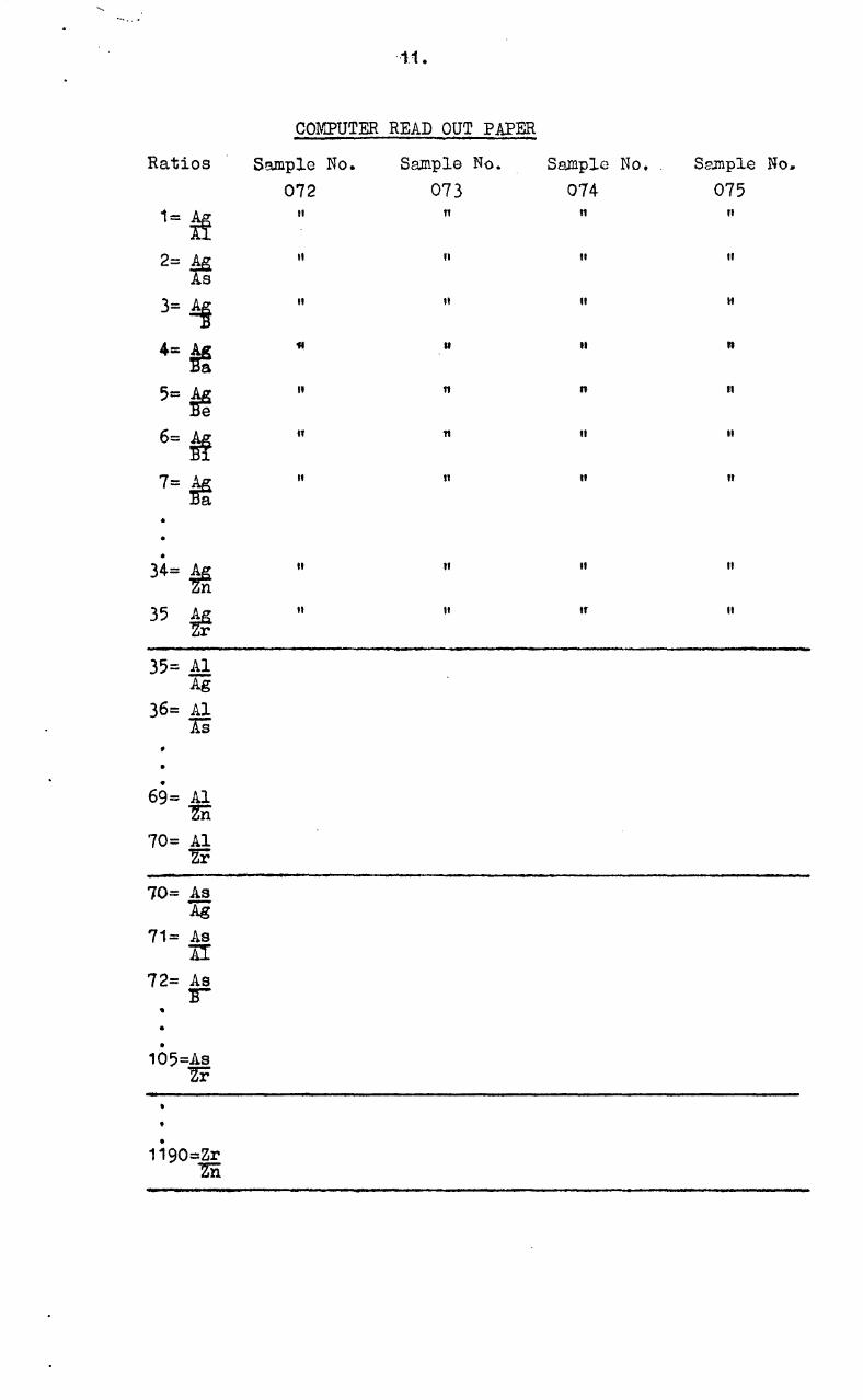
0 •••••
Ratios
1= ~
2= * 3= hi 4= ~
5= * 6= ~
7= * • • •
34= ¥n 35 ¥r 35= .AI
Ag 36= Al
AS • • •
69= Al rn 70= Al
Zr
10= As Ag
71= As AI
72= As 1r
• • •
105=As Zr
• •
1190=Zr rn
--1.1.
COMPUTER READ OUT P!PER
Sample No. Sample No. Sample No. S~JIlple No ..
072 073 074 075
" 11 11 "
" II " "
" " " " U It n
" 11 n II
If " II
" 11 " II
11 " " 11
" " If II
. i
12.
i. e. t.here are ··1--190 possible ratios for each sample point; traverses in detailed areas nverage about 17 sample points making a total of 20,230 possible ratios per traverse.
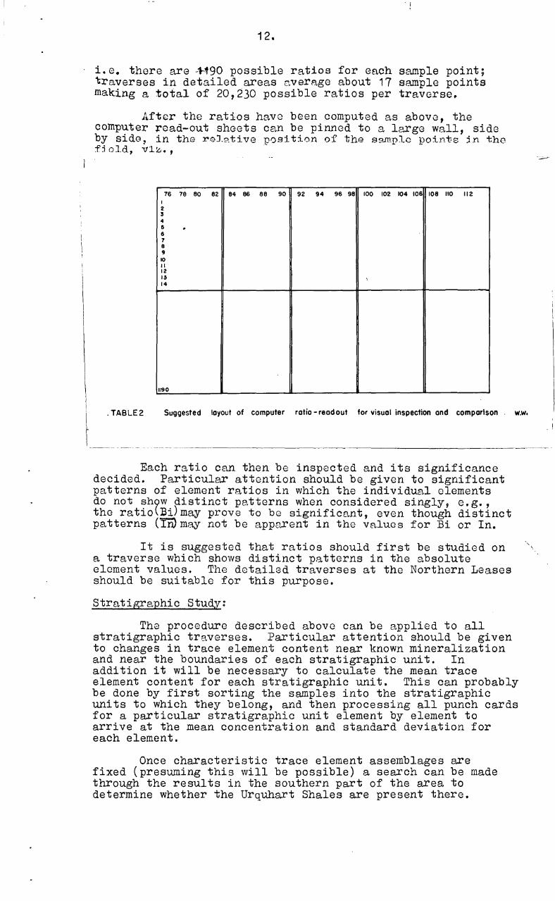
After the ratios have been computed as abovG, the computer ~ead-out sheets can be pinned to a large wall, side by sido 1 in thG roJ.?tive position of thG s9.ffiplc points jn tho f:i oJ.d, V 1:<:. • ,
76 78 80 82 84 86 88 90 92 94 96 98 100 102 104 106 108 110 112 I 2 5 4 6 . 6 7 8 9 10 II 12 15 , 14
1190
. TABLE2 Suggested layout of computer ratio - read out for visual inspection and comparison w.w •
Each ratio can then be inspected and its significance decided. Particular attention should be given to significant patterns of element ratios in which the individual elements do not sh9w distinct patterns when considered singly, e.g., the ratio~Ei)may prove to be significant, even though distinct patterns (TIVmay not be app9rent in the values for Bi or In.
It is suggested that ratios should first be studied on a traverse which shows distinct patterns in the absolute element values. The detailed traverses at the Northern Leases should be suitable for this purpose.
Stratigraphic Study:
The procedure described above can be applied to all stratigraphic traverses. Particular attention should be given to changes in trace element content near known mineralization and near the boundaries of each stratigraphic unit. In addition it will be necessary to calculate the mean trace element content for each stratigraphic unit. This can probably be done by first sorting the samples into the stratigraphic units to which they belong, and then processing all punch cards for a particular stratigraphic unit element by element to arrive at the mean concentration and standard deviation for each element.
Once characteristic trace element assemblages are fixed (presuming this will be possible) a search can be made through the results in the southern part of the area to determine whether the Urquhart Shales are present there.
-~.
13.
During initial examination of results along stratigraphic tra"V<ll'se, .the possibility of trace element patterns related to faulting should be kept in mind. This applies particularly to traversee 28, the east end of Dawn Area Gravity Traverse (Lagoon Creek Fault), 56 (Crystallena Fault), 53 (east extension of ~at.ive Bee Fault), and 51, in addition changes in trace element con"t(::l'lt may occur as one approaches the numerous strike faults (transverse fault~) in the area. These are particularly apparent south of Mount lsa where sev0ral blocks of Eastern Creek Volcanics have been upfaulted through the Mount lsa Shale succession.
Acknowledgements
The writer would like to thank most sincerely the management and staff of Mount lsa Mines Ltd for their cooperation and friendliness which allowed the work to be carried out smoothly and efficiently in a most cordial atmosphere. Particular thanks are due to W~ E.~. Bennet~, Chief Gcologistt Mr N. McHugh, Works Chemist, and Messrs R. Hewitt, D. Tester and. G. Battey, Senior Geologists. Appreciation is also due to Dr B. Po. Ws,lpole of the Bureau of rlineral Resources who conceiv0d and promoted the project with his enthusiasm.
48
16,OOOE
U)
8 t
47
I I
Eagle'a! _ ..... : ... -,.. : ~Cluny Judy ~
I Mid Eaa' , , 49
, · • • • • · , ~o
44 43
, 0'
I • ~I
41 MtNorif 40 W
1-""1 'jtCopalot • I • I I Copper o 1t i Conqu •• t : 40E
~2 •
39
Bureou of Minerol Resources, Geology ond Geophysics Au!JU$1 1965 To occompony Record 1964/128
, , • ,
36 • , • • • :
LOCALITY
54
~Biotite No.2 • ~37 •
• I ~south.l Naltve
Bee
I • , , ,
I
~Native 8 .. 53
MAP OF MOUNT ISA MINES LEASE SHOWING AREA COVERED BY GEOCHEMICAL SAMPLING
S5 * 0 WIIlt. I BI_ •
56
I I I I , I • •
22 ~
Hidden Valley
'" '" Hidden Treasure
Leichordt King '"
z o o o. '"
l.elcllardl
32 • I I I I I I
• I
Quorlzil" No'/O
31 30
29 I • • I I , I I I
28 I
z o o o. '" <J"
27 I
26
25W 25: .
\ 22 I
• •
17 • • '16 o •
z o o
i
• • , , , I I
•
PLATE 1
I , " •
o
'. 16,000 E ' . • '----- ,
\
• I I
• • • • , , , , , ,
F54/AI/5
Plate 2
MAP OF THE NORTHERN LEASES AREA, MT. ISA
SHOWING GEOCHEMICAL GRID
BASE
LINE
FAUL T
?
WE ST
5 ::....;69A. A R---------ZV117:9E: ------C TENS:114:. C.AES:7yi... .S....1 77S T 01:51U- - - - - - - - E N T I A T E 0
•^
?----..■--?--
No----;......ER.
....„.......:::::::zz--,...:...z....^......,^-- --.
.---' •--.1/'‘^' 13.N)ti: 7 ?IA**
\^I. ... ...^
V^
/
% No 5^'..^I %
1^■ I- - , -
P b •
I^
''. Pb
1^
"..::\ \ i‘ \^i-- ' V
/r-^%.^I".^...^.i...........1 .
k^\ ‘^r•
\ \^.^...^k \\ I
\ 1^..^C.:.^\ \i \ ‘
S14:11L.E$.***^-;----1\^
?
.......1
IIEs
.5.----14AL
.. Sill\\srErRAASTVEERX:EXTENSION
‘r.::e-----NAT/ vE
AK 014W AY
\TRAVERSE 3"-EAST EXTENSION
800^400^0^
800^1600^
2400 Feet
ReferenceNo 3 Shaft
••• *********^Path of mine water discharge
P b^Position of lead occurrences at surface
Outcrop boundary
xxxxxxxxxxx Gossanous and silicified outcrops
Mop reproduced with permission 'of Mt. Is° Mines Ltd.
Bureau of Mineral Resources, Geology and Geophysics.^July 1965 To accompany Record 1964/128^F54/A1/6 JK
""'"
MAP OF DAWN AND BERNBOROUGH AREA I M T. ISA SHOWING GEOCHEMICAL GRID t~CONTOTO+:::INGCONTOTO
I .. · ...
Plale 3
~r-.---------------------.------------------~~~---r--------~------~'~OOO~.--------~------~r-~.",oooloooE II
Reference
C·",· .",
~,
~
G.~II.mietlll'tlr.,..
II".,
Mtlp ,.p'tldllt:.d /#tIll p.,ml",."
tlf MI.I'tI M", •• LId.
uoo~t.~-------------------=~~~~~-------------=~-----u~--__________ ~~ ______________ __ .. OOE 2000.
t::::=:::s.iiiII ... ====::iO""' ... ""';;;;;""'ii:,'==-==::ii .......... ~I800.'UT
F 54/A1I7
,