Embed Size (px)
Citation preview

E2E Spatial InfrastructuresThe South Esk Hydrological Sensor Web
Andrew Terhorst
Project Lead: Real-Time Water Information Systems
6 December 2010
Water for a Healthy Country Flagship

The Problem
E2E Spatial Infrastructures Workshop 6 December 2010
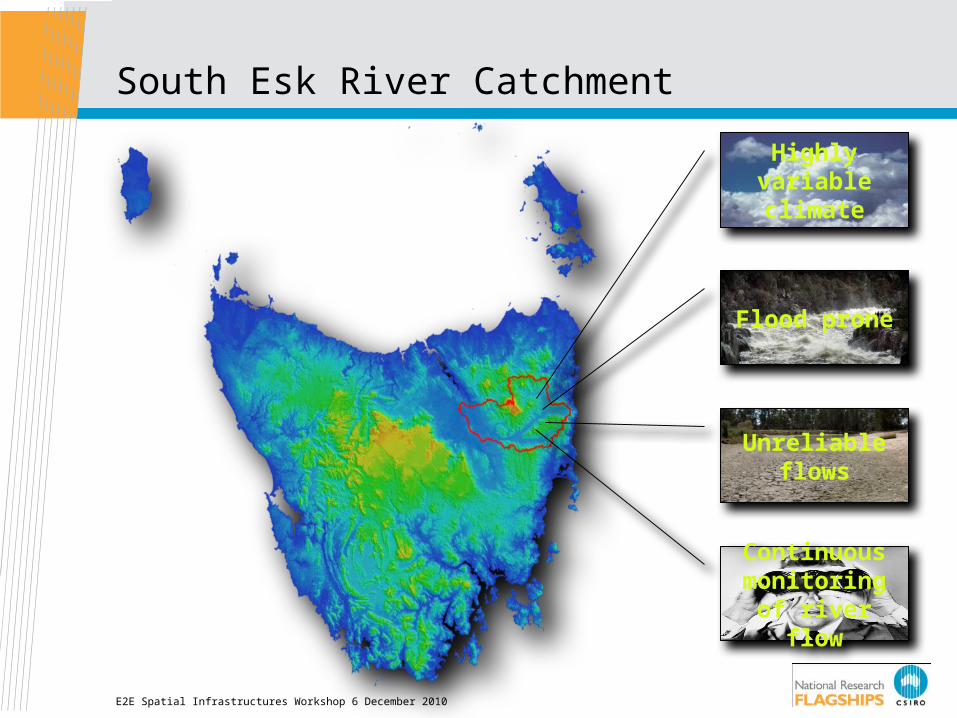
South Esk River Catchment
E2E Spatial Infrastructures Workshop 6 December 2010
Highly variable climate
Flood prone
Unreliable flows
Continuous monitoring of
river flow

Theoretical Model of Situation Awareness
E2E Spatial Infrastructures Workshop 6 December 2010
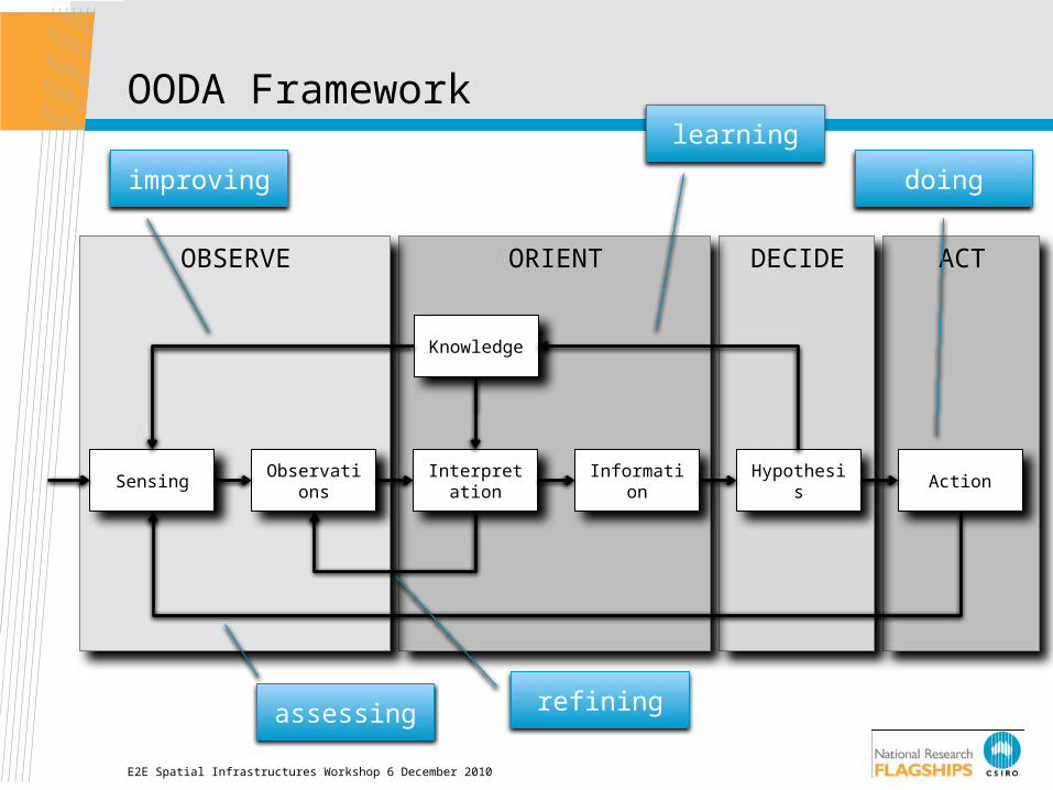
OODA Framework
E2E Spatial Infrastructures Workshop 6 December 2010
ACTDECIDEORIENTOBSERVE
Sensing ObservationsInterpretatio
nInformation Hypothesis Action
Knowledge
learning
doingimproving
refiningassessing

E2E Spatial Infrastructures Workshop 6 December 2010
Physical Sensors, Observation Archives
Numerical Models
Decision Support
Tools
Sensor Layer
Application Layer
Current Approach

E2E Spatial Infrastructures Workshop 6 December 2010
Physical Sensors, Observation Archives
Sensor Web
Numerical Models
Semantic Broker
Decision Support
Tools
Sensor Layer
Services Layer
Application Layer
Future Approach
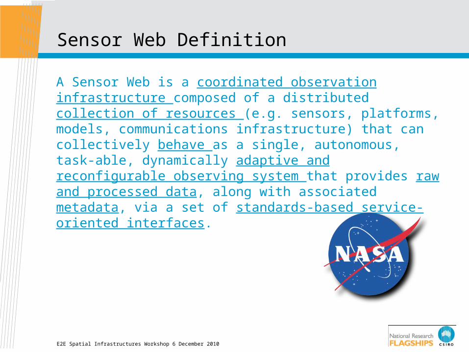
Sensor Web Definition
A Sensor Web is a coordinated observation infrastructure composed of a distributed collection of resources (e.g. sensors, platforms, models, communications infrastructure) that can collectively behave as a single, autonomous, task-able, dynamically adaptive and reconfigurable observing system that provides raw and processed data, along with associated metadata, via a set of standards-based service-oriented interfaces.
E2E Spatial Infrastructures Workshop 6 December 2010
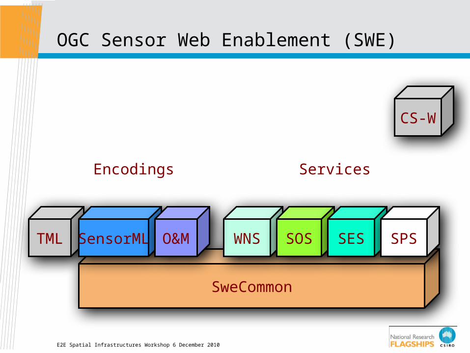
SweCommon
OGC Sensor Web Enablement (SWE)
WNS SOS SES
CS-W
TML SensorML O&M
Encodings Services
SPS
E2E Spatial Infrastructures Workshop 6 December 2010
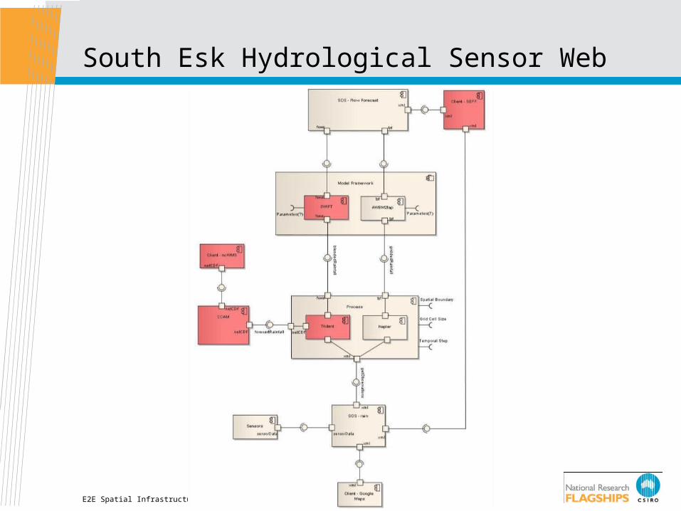
South Esk Hydrological Sensor Web
E2E Spatial Infrastructures Workshop 6 December 2010
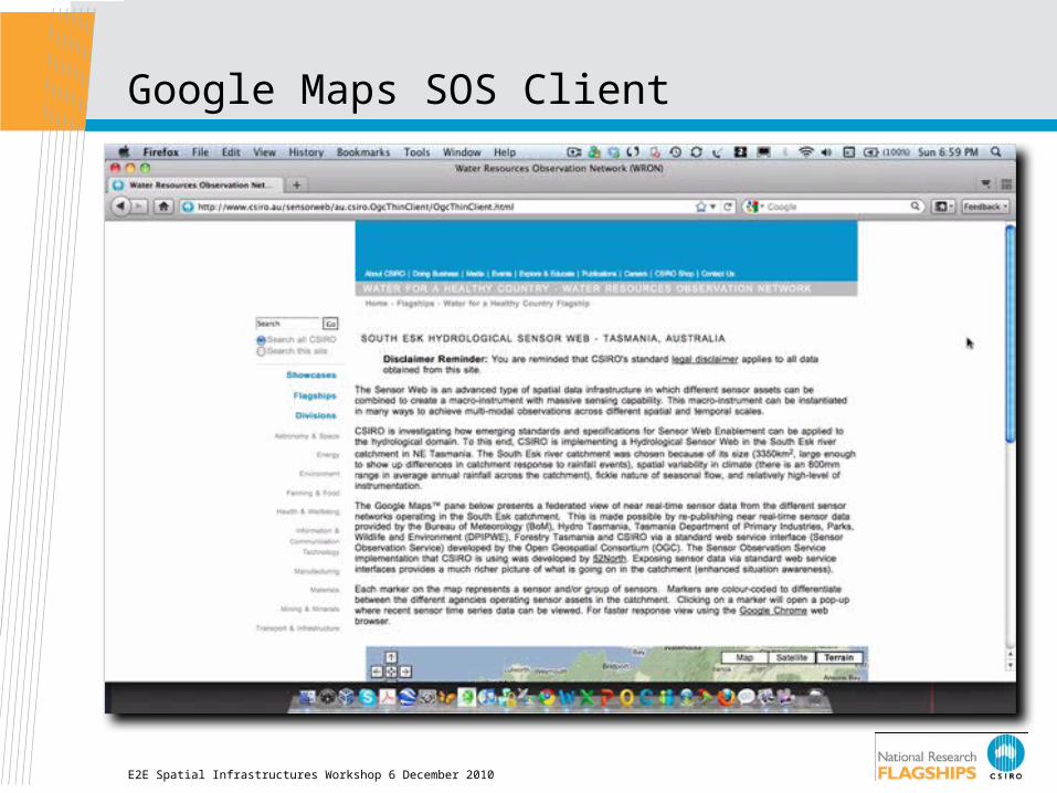
Google Maps SOS Client
E2E Spatial Infrastructures Workshop 6 December 2010
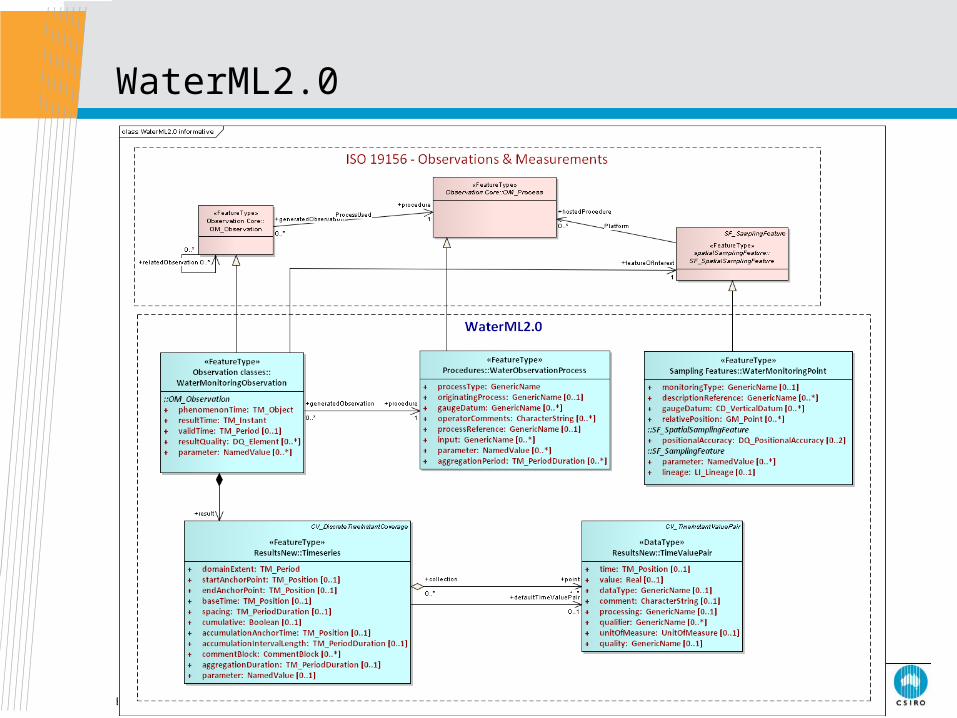
WaterML2.0
E2E Spatial Infrastructures Workshop 6 December 2010
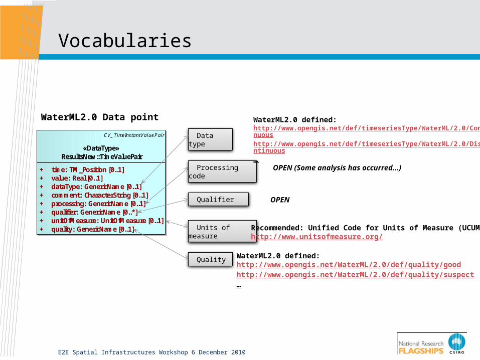
Vocabularies
E2E Spatial Infrastructures Workshop 6 December 2010
Quality
Data type
class WaterML2.0 informativ e
CV_TimeInstantValuePair
«DataType»ResultsNew::TimeValuePair
+ time: TM_Position [0..1]+ value: Real [0..1]+ dataType: GenericName [0..1]+ comment: CharacterString [0..1]+ processing: GenericName [0..1]+ qualifier: GenericName [0..*]+ unitOfMeasure: UnitOfMeasure [0..1]+ quality: GenericName [0..1] Units of measure
Processing code
Qualifier
WaterML2.0 defined:http://www.opengis.net/WaterML/2.0/def/quality/goodhttp://www.opengis.net/WaterML/2.0/def/quality/suspect…
Recommended: Unified Code for Units of Measure (UCUM):http://www.unitsofmeasure.org/
OPEN
OPEN (Some analysis has occurred…)
WaterML2.0 defined:http://www.opengis.net/def/timeseriesType/WaterML/2.0/Continuoushttp://www.opengis.net/def/timeseriesType/WaterML/2.0/Discontinuous…
WaterML2.0 Data point

Fle
xib
ilit
y
Levels of Interoperability
E2E Spatial Infrastructures Workshop 6 December 2010
Observation & Measurements
I know that an observation was made using this process on a phenomenon, with a result
Observation & Measurements + a vocabulary agreement
I understand the phenomenon you measured
WaterML2.0 sans vocabulary agreement
I know that an observation was made at a measuring station, using a sensor, and a time series was produced
I know that an observation was made using a measuring station, a sensor, and a time series is produced
WaterML2.0 + partial vocabulary agreement
I can understand the observations and import into my system directly, allowing full mapping to internal representation
WaterML2.0 + full vocabulary agreement
Sp
ecificity

Provenance Definition
Provenance of a resource is a record that describes entities and processes involved in producing and delivering or otherwise influencing that resource. Provenance provides a critical foundation for assessing authenticity, enabling trust, and allowing reproducibility. Provenance assertions are a form of contextual metadata and can themselves become important records with their own provenance.
E2E Spatial Infrastructures Workshop 6 December 2010

Provenance Information Model
E2E Spatial Infrastructures Workshop 6 December 2010
W3C Sensor Ontology
WaterML 2.0
Proof Mark-Up Language
Proof Mark-Up Language
Lineage Process
Domain
E2E Spatial Infrastructures Workshop 6 December 2010
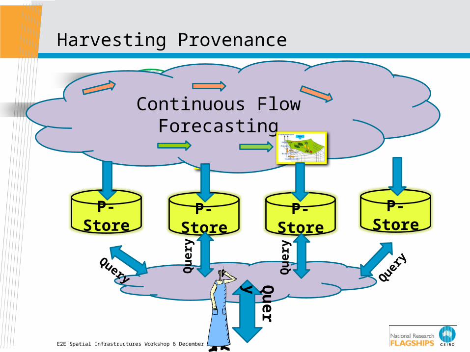
Harvesting Provenance
Continuous Flow Forecasting
P-Store P-Store P-Store P-Store
Query
Qu
ery
Qu
ery
Que
ry
Qu
ery

Provenance Information
E2E Spatial Infrastructures Workshop 6 December 2010
Conclusions
• Need well-documented use cases at appropriate level of granularity i.e. use design by contract methodology
• Architectural design should:• Promote re-use/re-purposing of data and infrastructure• Facilitate knowledge management• Enable discovery and exploration of web-based resource
• SWE standards are a moving target and complexity is an issue• Provenance enables/promotes data re-use/re-purposing• Linked open data approaches require serious consideration
E2E Spatial Infrastructures Workshop 6 December 2010
Thank you
Tasmanian ICT CentreAndrew TerhorstSenior Research Scientist
Phone: +61 3 6232 5541Email: [email protected]: www.csiro.au/ict
Contact UsPhone: 1300 363 400 or +61 3 9545 2176Email: [email protected] Web: www.csiro.au