Embed Size (px)
Citation preview
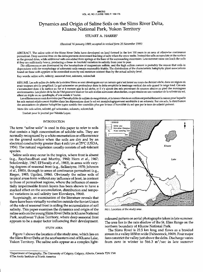
VOL. 43, NO. 2 (JUNE 1990) P. 159-175 ARCTIC
Dynamics and Origin of Saline Soils on the Slims River Delta, Kluane National Park, Yukon Territory
STUART A. HARRIS'
(Received 16 January 1989; accepted in revisedform 20 November 1989)
ABSTRACT. The saline soils of the Slims River Delta have developed on land formed in the last 100 years in an area of otherwise continuous permafrost. Deep seasonal frost on the delta prevents downward leaching of salts when the snow melts. Instead the salts accumulate at the surface as the ground dries, while additional salts are added from springs at the base of the surrounding mountains. Late summer rains can leach the soils if they are sufficiently heavy, producing a three- to fourfold variation in salinity from year to year.
The efflorescences are dominated by the hexahydrate of magnesium sulfate, and the high sulfate content is probably the reason that soils in depressions with the morphology of solonetzic soils remain reasonably friable. The distribution of the characteristic halophytic plant associations found on these soils appears to be controlled more by soil moisture content than by the actual salinity level. Key words: saline soils, salinity, seasonal frost, solonetz, solonchak
RÉSUMÉ. Les sols salins du delta de la riviere Slims se sont développés sur un terrain qui s'est formé au cours du dernier siècle, dans un région OÙ avait toujours sévi le pergélisol. Le gel saisonnier en profondeur dans le delta empêche le lessivage vertical des sels quand la neige fond. Ces sels s'accumulent donc à la surface au fur et à mesure que le sol skhe, et il s'y ajoute des sels provenant de sources situées au pied des montagnes environnantes. Les pluies de la fin de l'été peuvent lessiver les sols si elles sont assez abondantes, ce qui résulte en une variation de la salinité du sol, allant au triple ou au quadruple, d'une année à l'autre.
Les efflorescences sont dominées par l'hexahydrite de sulfate de magnésium, et la teneur élevée en sulfate est probablement la raison pour laquelle les sols restent relativement friables dans les dépressions dont le sol est morphologiquement semblable à un solonetz. Sur ces sols, la distribution des associations de plantes halophiles types semble être contrôlée plus par le taux d'humidité du sol que par le taux de salinité présent. Mots clés: sols salins, salinité, gel saisonnier, solonetz, solontchak
Traduit pour le journal par Nésida Loyer.
INTRODUCTION
The term "saline soils" is used in this paper to refer to soils that contain a high concentration of soluble salts. They are normally recognized by a white encrustation or efflorescence on the ground surface when the soils are dry and by an electrical conductivity greater than 4 mS/cm at 25°C (USDA, 1954). The natural vegetation usually consists of salt-tolerant species.
Saline soils may occur in the tropics, where frost is absent (e.g., Raychaudhuri and Murthy, 1960; Horn et al., 1967; Sokolovskiy, 1967; El'Swaify et al., 1983), in areas with vary- ing degrees of seasonal frost ( eg , Ballantyne, 1978; Johnson et al., 1985), through to areas of continuous permafrost (e.g., Reger, 1983; Ugolini, 1986). Obviously the saline soils of tropical areas form without any influence of frost, in contrast to those of permafrost regions, where the influence of essen- tially impermeable frozen layers has been shown to have a marked effect on the accumulation, distribution and tempo- ral variations in soil salinity (see Elovskaya, 1964).
Surprisingly, an examination of the literature reveals that there have been virtually no studies outside the Soviet Union of the role of seasonal frost in aiding the accumulation of soil salinity. This paper examines the dynamics and origin of the saline soils on the young Slims River Delta in Kluane National Park, southwest Yukon Territory, where deep seasonal frost appears to be a major factor influencing their development.
STUDY AREA
Figure 1 shows the location of the study area, which lies on the Slims River Delta at the southeastern end of Kluane Lake, Yukon Territory. The saline soils appear as a complex light-
Lake
FIG 1. Location of the study area.
coloured pattern on aerial photographs taken in late summer. The area lies in the rain shadow of the St. Elias Range on the northern boundary of Kluane National Park.
The Slims River is 22.5 km long and flows as a braided stream in a valley 1830 m wide (Fahnestock, 1969). Four major fans constrict the valley just above the delta. Discharge varies from zero in winter to 566.3 m3/sec in late summer
'Department of Geography, The University of Calgary, Calgary, Alberta, Canada T2N 1N4 @The Arctic Institute of North America
160 / S.A. HARRIS
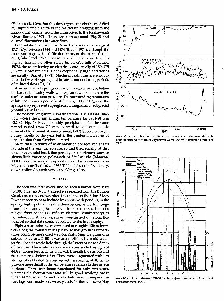
(Fahnestock, 1969), but this flow regime can also be modified by unpredictable shifts in the meltwater draining from the Kaskawulsh Glacier from the Slims River to the Kaskawulsh River (Barnett, 1971). There are both seasonal (Fig. 2) and diurnal fluctuations in water flow.
Progradation of the Slims River Delta was an average of 17.7 m/yr between 1944 and 1974 (Bryan, 19741, although the exact rate of growth is difficult to measure due to the fluctu- ating lake levels. Water conductivity in the Slims River is higher than in the other rivers tested (Foothills Pipelines, 1976), the water having an electrical conductivity of 180-425 pS/cm. However, this is not exceptionally high and varies seasonally (Barnett, 1971). Maximum salinities are encoun- tered in the early spring and in late summer during periods of reduced flow (Fig. 2).
A series of small springs occurs on the delta surface below the base of the valley walls where groundwater comes to the surface under artesian pressure. The surrounding mountains exhibit continuous permafrost (Harris, 1983, 1987), and the springs may represent superglacial, intraglacial or subglacial groundwater flow.
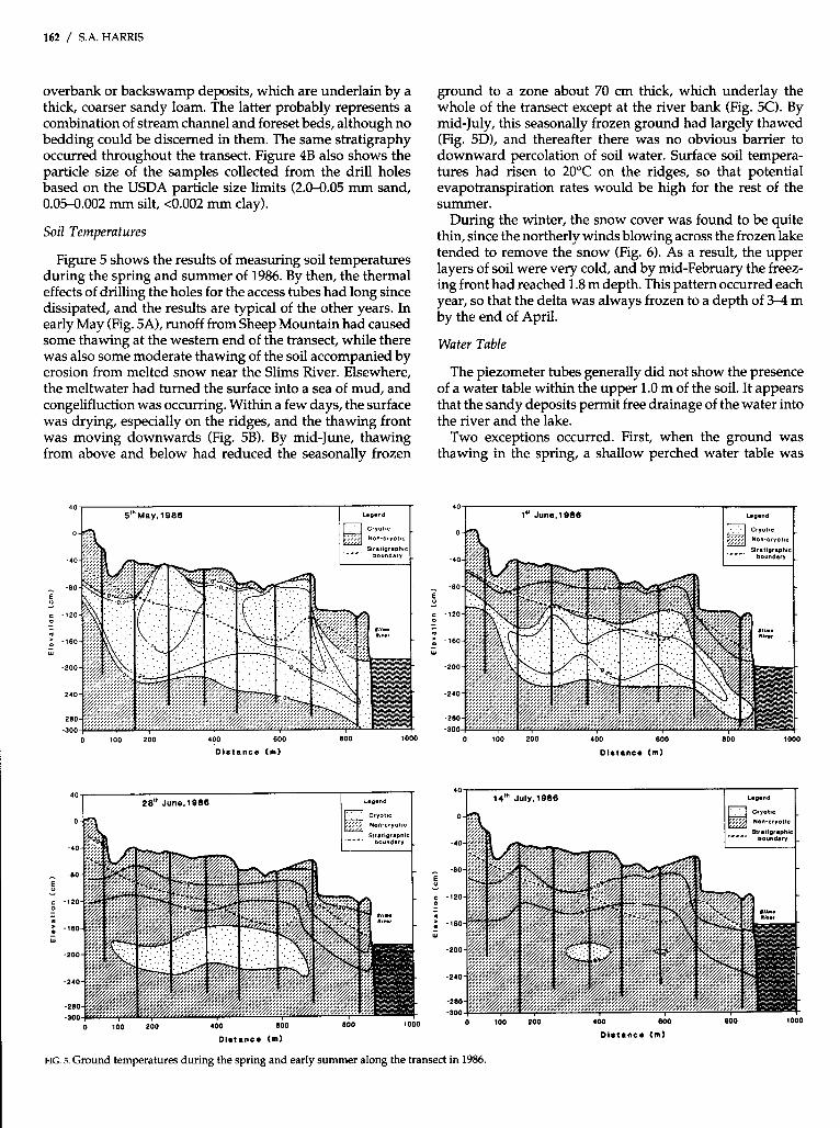
The nearest long-term climatic station is at Haines Junc- tion, where the mean annual temperature for 1951-80 was -3.2"C (Fig. 3). Mean monthly precipitation for the same period varied from 7.9 mm in April to 36.3 mm in July (Canada Department of Environment, 1982). Snow may occur in any month of the year but is the predominant form of precipitation from October to April.
More than 18 hours of solar radiation are received at this latitude at the summer solstice, so that theoretically, at that time of year, total insolation per day on a horizontal surface shows little variation polewards of 55" latitude (Johnston, 1981). Potential evapotranspiration can be considerable in May and June (Wahl et al., 1987Table 11.61, aided by the dry, down-valley Chinook winds (Nickling, 1976).
METHODS
The area was intensively studied each summer from 1985 to 1988. First, an 870 m transect was selected from the Bullion Creek access road eastwards to the channel of the Slims River. It was chosen so as to include low spots with ponding in the spring, high spots with salt efflorescences, and a full range from maximum vegetation cover to barren areas. The soils ranged from saline (>4 mS/cm electrical conductivity) to nonsaline soil. A leveling survey was carried out along this transect so that data could be related to the topography.
Eight access tubes were emplaced at roughly 100 m inter- vals along the transect in May 1985, so that ground tempera- tures could be monitored without disturbing the ground in subsequent years. Drilling was accomplished by a cold-water jet drill that thawed a hole through the layers of ice to a depth of 2-3.5 m. Thermistor cables were constructed using YSI 44033 thermistors at 25 cm intervals beneath the surface and 50 cm intervals below 1.5 m. These were augmented with 1 m strings of calibrated transistors with a spacing of 10 cm to provide more detail of the temperature changes in the surface horizons. These transistors functioned for only two years, whereas the thermistors were still in good working order when removed at the end of the field work. Temperature readings were made on a weekly basis for the summers (May
1 I I
4 CONDUCTIVITY
May ' June ' July I August 1987
FIG. 2. Variation in level of the Slims River in relation to the mean daily air temperature and to conductivity of river water (pSS/cm) during the summer of 1987.
J F M A M J J A S O N O
FLG.3. Mean climatic data for 1951-80 for Haines Junction (Canada Department of Environment, 1982).

SLIMS RIVER DELTA SALINE SOILS / 161
to August inclusive) from June 1985 until 20 August 1987. Where possible, winter readings were also obtained.
Groundwater levels were monitored using capped PVC piezometer tubes installed by drilling to between 85 cm and 2 mat each site. The bottom of the piezometer tube was sealed and saw cuts were made in the lower 45 cm to permit inflow of any groundwater. Later, shallower piezometer tubes were added to monitor perched water tables. Again, weekly meas- urements were obtained of the water level, if any, in each tube.
Twenty-five soil sampling sites were designated along the transect so that repeated soil sampling could be carried out to assess the level of salinity and its seasonal variations with topographic position, soil moisture and the position of any seasonal frost. Soil samples were collected once a week using a hand auger, sampling the soil at 5,30,60 and 90 cm, or to the frost table, whichever was shallower. This allowed confirma- tion of the results of the ground temperature data. At Kluane Lake Research Station (of the Arctic Institute of North Amer- ica), they were air dried and then salinity was measured in a 1:4, soi1:water solution using a Hach Model 16300 portable conductivity meter and solutions of standard concentration (USDA, 1954; Rhoades, 1976).
Samples were also collected of the salt efflorescence on the soil surface for X-ray diffraction in the Geology Department, University of Calgary. Following problems with change in hydration during storage, all the later samples were sprayed with a clear plastic coating (Krylon) to prevent transforma- tion.
Typical soil profiles were examined and described in pits dug approximately 10 m ENE of the temperature monitoring sites. These included the main variations in the soils on the delta, and samples were collected for particle size and con- ductivity analysis. The particle analysis was carried out in the laboratories of the Geography Department, University of Calgary, using the pipette method of Elmer and Alexander (1949). Calgon was used as the dispersant after treatment with hydrogen peroxide.
Water samples were collected from the groundwater in the piezometer tubes from springs at the foot of Sheep Mountain, from Kluane Lake, and from the Slims River. These were submitted to the Environment Canada water analysis labora- tory in Vancouver for analysis (see Appendix A for methods used), and additional samples were analyzed by Dr. A.A. Levinson at the Geology Department, University of Calgary.
In July 1986 and 1987, the distribution of salinity in the surface soils was mapped on the west side of the river using a 100 m grid, with soil samples being collected at 10 and 20 cm depths at each grid point. This allowed a study to be carried out of the variability of the salinity over a large area of the west side of the delta in these two summers.
The plant communities present were identified by repeated visual inspections along the transect in 1985. A detailed description was made of the variations in vegetation, includ- ing species composition, abundance and percentage cover. Where these changed markedly, a community boundary was identified. Plots 2 X 2 m in size and spaced 15 m apart along the transect were utilized, together with additional plots drawn from a table of random numbers. The majority of the species were in the herbaceous layer, exceptions including Populus balsamifera and Salix spp. Each community was given
a floristic name describing the dominant or Co-dominant species, the dominant species being defined as the one that occupied the most space based on the cover-abundance esti- mate. Specimens of the plants were collected, pressed and dried, and the species determined in the herbarium of the Department of Biology, University of Calgary. The species of Salix were identified by Dr. G.W. Argus, National Museums of Canada, Ottawa. The grasses were identified by Mrs. K.H. Wilkinson, and for a selection of critical examples the identi- fications were confirmed by the Department of Agriculture, Ottawa.
Finally, samples were taken of the soil in the rooting zone of the various plant species on the delta so as to determine the salinity tolerances of each species. The salinity of these soil samples was determined in the same manner as that of the weekly samples from the soil sampling sites, while the mois- ture content at the time of sampling was determined gravimetrically.
RESULTS FROM THE TRANSECT
Topography and Stratigraphy
The cross-section (Fig. 4A) shows that the delta has a gently undulating surface with a general slope towards the river. The depressions originated partly as old distributary chan- nels and partly by wind erosion (see Nickling, 1976, 1978). They are undergoing further modification by wind action, congelifluction as the snow cover thaws in the spring and slope wash as the meltwater drains to the river channel. All these processes are operating on the upper silty layer of
A 40 SLIMS RIVER DELTA- STRATIGRAPHY E
O
-40
- -80
5 c -120 z
-160 - Y
-200
-280
-300 O 100
l! 200 400 600 800 1000
Dnslance [ml
- B
FIG. 4. A) Topography and stratigraphy along the transect across the west side of the Slims River Delta. B) Grain size of the sediments.
162 / S.A. HARRIS
overbank or backswamp deposits, which are underlain by a thick, coarser sandy loam. The latter probably represents a combination of stream channel and foreset beds, although no bedding could be discerned in them. The same stratigraphy occurred throughout the transect. Figure 4B also shows the particle size of the samples collected from the drill holes based on the USDA particle size limits (2.0-0.05 mm sand, 0.05-0.002 mm silt, <0.002 mm clay).
Soil Temperatures
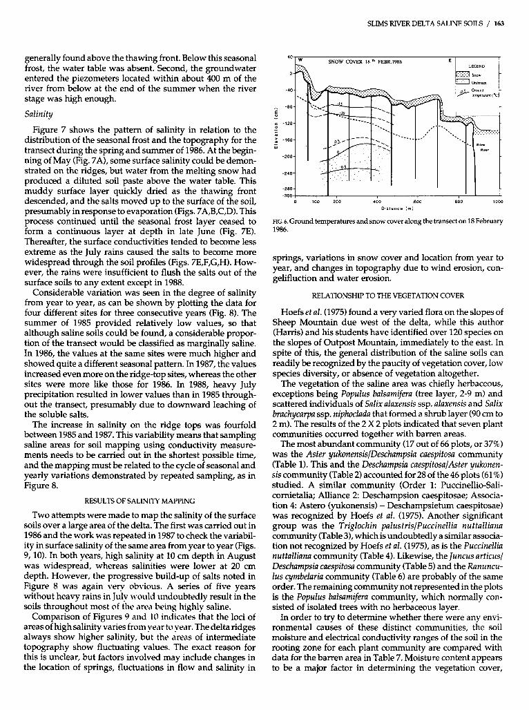
Figure 5 shows the results of measuring soil temperatures during the spring and summer of 1986. By then, the thermal effects of drilling the holes for the access tubes had long since dissipated, and the results are typical of the other years. In early May (Fig. 5A), runoff from Sheep Mountain had caused some thawing at the western end of the transect, while there was also some moderate thawing of the soil accompanied by erosion from melted snow near the Slims River. Elsewhere, the meltwater had turned the surface into a sea of mud, and congelifluction was occurring. Within a few days, the surface was drying, especially on the ridges, and the thawing front was moving downwards (Fig. 5B). By mid-June, thawing from above and below had reduced the seasonally frozen
0 100 200 400 600 800 1000
D l a i a n c e ( m )
ground to a zone about 70 cm thick, which underlay the whole of the transect except at the river bank (Fig. 5 0 . By mid-July, this seasonally frozen ground had largely thawed (Fig. 5D), and thereafter there was no obvious barrier to downward percolation of soil water. Surface soil tempera- tures had risen to 20°C on the ridges, so that potential evapotranspiration rates would be high for the rest of the summer.
During the winter, the snow cover was found to be quite thin, since the northerly winds blowing across the frozen lake tended to remove the snow (Fig. 6). As a result, the upper layers of soil were very cold, and by mid-February the freez- ing front had reached 1.8 m depth. This pattern occurred each year, so that the delta was always frozen to a depth of 3-4 m by the end of April.
Water Table
The piezometer tubes generally did not show the presence of a water table within the upper 1.0 m of the soil. It appears that the sandy deposits permit free drainage of the water into the river and the lake.
Two exceptions occurred. First, when the ground was thawing in the spring, a shallow perched water table was
40 1" June.1088
0 100 200 400 600 800 1000
Dfeianca (m)
100 200 400 800
Dla tance (m)
800 1000
FIG. 5. Ground temperatures during the spring and early summer along the transect in 1986.
SLIMS RIVER DELTA SALINE SOILS / 163
generally found above the thawing front. Below this seasonal frost, the water table was absent. Second, the groundwater entered the piezometers located within about 400 m of the river from below at the end of the summer when the river stage was high enough.
Salinity
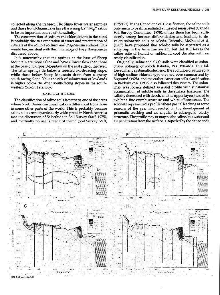
Figure 7 shows the pattern of salinity in relation to the distribution of the seasonal frost and the topography for the transect during the spring and summer of 1986. At the begin- ning of May (Fig. 7A), some surface salinity could be demon- strated on the ridges, but water from the melting snow had produced a diluted soil paste above the water table. This muddy surface layer quickly dried as the thawing front descended, and the salts moved up to the surface of the soil, presumably in response to evaporation (Figs. 7A,B,C,D). This process continued until the seasonal frost layer ceased to form a continuous layer at depth in late June (Fig. 7E). Thereafter, the surface conductivities tended to become less extreme as the July rains caused the salts to become more widespread through the soil profiles (Figs. 7E,F,G,H). How- ever, the rains were insufficient to flush the salts out of the surface soils to any extent except in 1988.
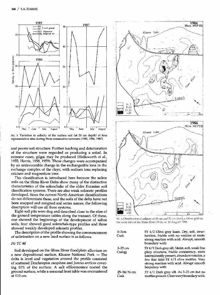
Considerable variation was seen in the degree of salinity from year to year, as can be shown by plotting the data for four different sites for three consecutive years (Fig. 8). The summer of 1985 provided relatively low values, so that although saline soils could be found, a considerable propor- tion of the transect would be classified as marginally saline. In 1986, the values at the same sites were much higher and showed quite a different seasonal pattern. In 1987, the values increased even more on the ridge-top sites, whereas the other sites were more like those for 1986. In 1988, heavy July precipitation resulted in lower values than in 1985 through- out the transect, presumably due to downward leaching of the soluble salts.
The increase in salinity on the ridge tops was fourfold between 1985 and 1987. This variability means that sampling saline areas for soil mapping using conductivity measure- ments needs to be carried out in the shortest possible time, and the mapping must be related to the cycle of seasonal and yearly variations demonstrated by repeated sampling, as in Figure 8.
RESULTS OF SALINITY MAPPING
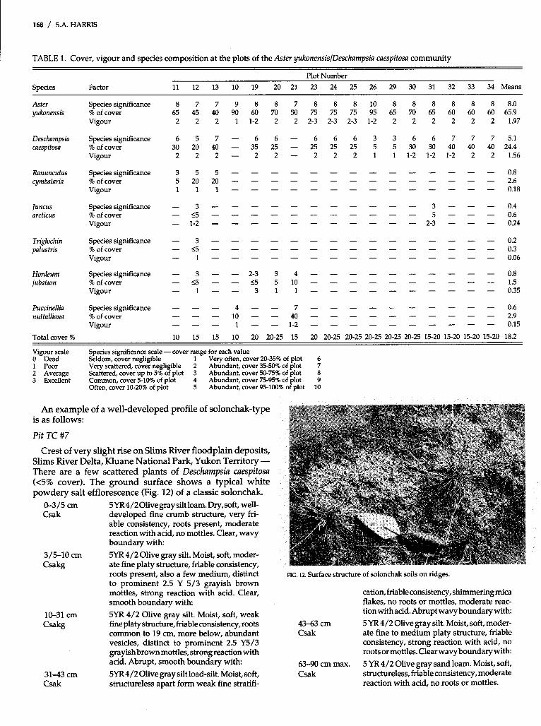
Two attempts were made to map the salinity of the surface soils over a large area of the delta. The first was carried out in 1986 and the work was repeated in 1987 to check the variabil- ity in surface salinity of the same area from year to year (Figs. 9,lO). In both years, high salinity at 10 cm depth in August was widespread, whereas salinities were lower at 20 cm depth. However, the progressive build-up of salts noted in Figure 8 was again very obvious. A series of five years without heavy rains in July ~ v o u l d undoubtedly result in the soils throughout most of the area being highly saline.
Comparison of Figures 9 and 1 0 indicates that the loci of areas of high salinity varies from year to year. The delta ridges always show higher salinity, but the areas of intermediate topography show fluctuating values. The exact reason for this is unclear, but factors involved may include changes in the location of springs, fluctuations in flow and salinity in
40 I w E l
-80
E, c -120 0
-160 - w
-200
-240
-280
SNOW COVER I8 th FEBR 1986
0 100 200 400 600 800 1
DlSIance lrnl 000
FIG. 6. Ground temperatures and snow cover along the transect on 18 February 1986.
springs, variations in snow cover and location from year to year, and changes in topography due to wind erosion, con- gelifluction and water erosion.
RELATIONSHIP TO THE VEGETATION COVER
Hoefs et al. (1975) found a very varied flora on the slopes of Sheep Mountain due west of the delta, while this author (Harris) and his students have identified over 120 species on the slopes of Outpost Mountain, immediately to the east. In spite of this, the general distribution of the saline soils can readily be recognized by the paucity of vegetation cover, low species diversity, or absence of vegetation altogether.
The vegetation of the saline area was chiefly herbaceous, exceptions being Populus balsamifera (tree layer, 2-9 m) and scattered individuals of Salix alaxensis ssp. alaxensis and Salix bruchycarpa ssp. niphoclada that formed a shrub layer (90 cm to 2 m). The results of the 2 X 2 plots indicated that seven plant communities occurred together with barren areas.
The most abundant community (17 out of 66 plots, or 37%) was the Aster yukonensis/Deschampsia caespitosa community (Table 1). This and the Deschampsia cuespitosa/Aster yukonen- sis community (Table 2) accounted for 28 of the 46 plots (61 %) studied. A similar community (Order 1: Puccinellio-Sali- cornietalia; Alliance 2: Deschampsion caespitosae; Associa- tion 4: Astero (yukonensis) - Deschampsietum caespitosae) was recognized by Hoefs et al. (1975). Another significant group was the Triglochin palustris/Puccinellia nuttalliana community (Table 31, which is undoubtedly a similar associa- tion not recognized by Hoefs et al. (19751, as is the Puccinellia nuttalliana community (Table 4). Likewise, the Juncus articusl Deschampsia cuespitosa community (Table 5) and the Rununcu- lus cymbelaria community (Table 6) are probably of the same order. The remaining community not represented in the plots is the Populus balsamifera community, which normally con- sisted of isolated trees with no herbaceous layer.
In order to try to determine whether there were any envi- ronmental causes of these distinct communities, the soil moisture and electrical conductivity ranges of the soil in the rooting zone for each plant community are compared with data for the barren area in Table 7. Moisture content appears to be a major factor in determining the vegetation cover,

162 / S.A. HARRIS
overbank or backswamp deposits, which are underlain by a thick, coarser sandy loam. The latter probably represents a combination of stream channel and foreset beds, although no bedding could be discerned in them. The same stratigraphy occurred throughout the transect. Figure 4B also shows the particle size of the samples collected from the drill holes based on the USDA particle size limits (2.0-0.05 mm sand, 0.05-0.002 mm silt, <0.002 mm clay).
Soil Temperatures
Figure 5 shows the results of measuring soil temperatures during the spring and summer of 1986. By then, the thermal effects of drilling the holes for the access tubes had long since dissipated, and the results are typical of the other years. In early May (Fig. 5A), runoff from Sheep Mountain had caused some thawing at the western end of the transect, while there was also some moderate thawing of the soil accompanied by erosion from melted snow near the Slims River. Elsewhere, the meltwater had turned the surface into a sea of mud, and congelifluction was occurring. Within a few days, the surface was drying, especially on the ridges, and the thawing front was moving downwards (Fig. 5B). By mid-June, thawing from above and below had reduced the seasonally frozen
ground to a zone about 70 cm thick, which underlay the whole of the transect except at the river bank (Fig. 5C). By mid-July, this seasonally frozen ground had largely thawed (Fig. 5D), and thereafter there was no obvious barrier to downward percolation of soil water. Surface soil tempera- tures had risen to 20°C on the ridges, so that potential evapotranspiration rates would be high for the rest of the summer.
During the winter, the snow cover was found to be quite thin, since the northerly winds blowing across the frozen lake tended to remove the snow (Fig. 6). As a result, the upper layers of soil were very cold, and by mid-February the freez- ing front had reached 1.8 m depth. This pattern occurred each year, so that the delta was always frozen to a depth of 3-4 m by the end of April.
Water Table
The piezometer tubes generally did not show the presence of a water table within the upper 1.0 m of the soil. It appears that the sandy deposits permit free drainage of the water into the river and the lake.
Two exceptions occurred. First, when the ground was thawing in the spring, a shallow perched water table was
5Ih May, 1088
O 100 200 400 600 800 1000
D i a t a n c e ( m ) 6 100 260 400 600 800 1000
D l r tanca (nt)
"_ , O 100 200 400 800 800 1000
OIatanco ( m l
FIG. 5. Ground temperatures during the spring and early summer along the transect
O
in 1986.
100 200 SO0 1000
SLIMS RIVER DELTA SALINE SOILS / 165
collected along the transect. The Slims River water samples and those from Kluane Lake have the wrong Ca++: Mg++ ratios to be an important source of the salinity.
The concentration of sodium and chloride ions in the pond is probably due to evaporation of water and precipitation of crystals of the soluble sodium and magnesium sulfates. This would be consistent with the mineralogy of the efflorescences discussed above.
It is noteworthy that the springs at the base of Sheep Mountain are more saline and have a lower flow than those at the base of Outpost Mountain on the east side of the river. The latter springs lie below a forested north-facing slope, while those below Sheep Mountain drain from a grassy south-facing slope. Thus the risk of salinization of lowlands is higher below the drier south-facing slopes in the south- western Yukon Territory.
NATURE OF THE SOILS
The classification of saline soils is perhaps one of the areas where North American classifications differ most from those in some other parts of the world. This is probably because saline soils are not particularly widespread in North America (see the discussion of Salorthids in Soil Survey Staff, 19751, and “virtually no use is made of them” (Soil Survey Staff,
1975:177). In the Canadian Soil Classification, the saline soils only seem to be differentiated at the soil series level (Canada Soil Survey Committee, 1978), unless there has been suffi- ciently strong horizon differentiation and leaching to de- velop solonetzic soils or solods. Recently, McQuaid et al. (1987) have proposed that solodic soils be separated as a subgroup in the American system, but this still leaves the saline soils of humid or subhumid cool climates with no ready classification.
Originally, saline and alkali soils were classified as solon- chaks, solonetz or solods (Glinka, 1931:428-465). This fol- lowed many systematic studies of the evolution of saline soils of high sodium chloride type that had been summarized by Sigmund (1928), and the earlier American soils classification in Baldwin et al. (1938) also followed this system. The solon- chak was loosely defined as a soil profile with substantial accumulation of soluble salts in the surface horizons. The salinity decreased with depth, and the upper layers tended to exhibit a fine crumb structure and white efflorescence. The solonetz represented a profile where partial leaching at some seasons of the year had resulted in the development of prismatic cracking and an angular to subangular blocky structure. The profile may or may not be saline, but water and air penetration from the surface is impeded by the dense peds
166 / S.A. HARRIS
1986
I May ' June ' July 'August
O
1987
May ' June ' July ' Augus
FIG. 8. Variation in salinity of the surface soil (at 20 cm depth) at four representative sites during three consecutive summers (1985,1986,1987).
and poorer soil structure. Further leaching and deterioration of the structure were regarded as producing a solod. In extreme cases, gilgai may be produced (Hallsworth et al., 1955; Harris, 1958,1959). These changes were accompanied by an unfavourable change in the exchangeable ions in the exchange complex of the clays, with sodium ions replacing calcium and magnesium ions.
This classification is introduced here because the saline soils on the Slims River Delta show many of the distinctive characteristics of the solonchaks of the older Eurasian soil classification systems. There are also weak solonetz profiles developed. Since the current North American classifications do not differentiate these, and the soils of the delta have not been mapped and assigned soil series names, the following description will use all three systems.
Eight soil pits were dug and described close to the sites of the ground temperature cables along the transect. Of these, one showed the beginnings of the development of saline soils, four showed good solonchak-type profiles and three showed weakly developed solonetz profiles.
The description of the profile showing the commencement of salinization on a new land surface is as follows:
Pit TC #8
Soil developed on the Slims River floodplain alluvium on a new depositional surface, Kluane National Park - The delta is level and vegetation around the profile consisted of scattered Deschampsia caespitosa and ]uncus arcticus cover- ing 10% of the surface. A salt efflorescence coated the ground surface, while a seasonal frost table was encountered at 110 cm.
FIG. 9 Distribution of salinity at 10 cm and 20 cm along a 100 m grid on the west side of the Slims River Delta on 16 August 1986.
0-3cm 5Y 4/2 Olive gray loam. Dry, soft, struc- Csak tureless, friable with no vesicles or roots;
strong reaction with acid. Abrupt, smooth boundary with
3-25 cm 5Y 4/1 Dark gray silt. Moist, soft, weak fine Csakgj platy structure, friable consistency, roots
intermittently present, abundant vesicles, a few fine faint 5Y 4/3 olive mottles. Very strong reaction with acid. Abrupt smooth boundary with
25-34/36 cm 5Y 4/1 Dark gray silt. As 3-25 cm but no Csak mottles present. Clear wavy boundary with

SLIMS RIVER DELTA SALINE SOILS / 167
HG. IO. Distribution of salinity at 10 c m and 20 cm along a 100 m grid on the west side of the Slims River Delta on 12 August 1987. The sampling sites are the same as in Figure 9.
3 4 / 3 6 5Y 4/1 Dark gray silt. Very moist, soft, 44/45 cm weak fine platy structure, friable consis-
Ck tency, fine bedding present, no vesicles or roots present, shimmering mica flakes, a strong reaction with acid. Clear wavy boundary with
68/69 cm Ck
moist, soft, structureless, friable consistency, saturated bands present, strong reaction with acid, no vesicles, no roots. Clear wavy boundary with
44/45 5Y 4/2 Olive gray silty clay loam. Very
Pit TC #8 are given in Tabie 9. This is a young soil fArmed on the overbank deposits adjacent to a distributary channel of the Slims River. Note that salinization is slowly developing and mottling of the surface horizons has just begun. This surface-water gleying must be occurring immediately after snow melt, since this is the only time of the year when the surface horizons are sufficiently wet.
The general, if erratic, decrease in pH with depth is charac- teristic of all the profiles on the transect, as is the fine-medium platy structure in the lower horizons of the silty surface material. The platy structure often shows more sandy layers along the horizontal partings, suggesting that the structure may be the result of alluvial deposition of the parent material. Alternatively this structure may develop as the result of freezing and thawing with the development of thin ice lenses (Tedrow, 1977; van Vliet-Lanoë, 1988).
168 / S.A. HARRIS
TABLE 1. Cover, vigour and species composition at the plots of the Aster yukonensis/Deschampsiu caespifosa community
Species Factor Plot Number
11 12 13 10 19 20 21 23 24 25 26 29 30 31 32 33 34 Means
Aster yukonensis
Deschnmpsia caespitosa
Ranunculus cymbalaria
Juncus arcticus
Triglochin palustris
Hordeum jubatum
Puccinellia nuttalliana
Total cover %
Species significance % of cover Vigour
Species significance % of cover Vigour
Species sigruficance % of cover Vigour
Species significance % of cover Vigour
Species significance % of cover Vigour
Species significance % of cover Vigour
Species significance % of cover Vigour
Vigour scale Species significance scale - cover range for each value O Dead 1 Poor
Seldom, cover negligible 1 Very often, cover 2045% of plot 6
2 Average Scattered, cover up to 5% of plot 3 Abundant, cover 50-75% of plot 8 Very scattered, cover negligible 2 Abundant, cover 35-50% of plot 7
3 Excellent Common, cover 5-10% of plot 4 Abundant, cover 75-95% of plot 9 Often, cover 1020% of plot 5 Abundant, cover 95-100% of plot 10
An example of a well-developed profile of solonchak-type is as follows:
Pit TC #7
Crest of very slight rise on Slims River floodplain deposits, Slims River Delta, Kluane National Park, Yukon Territory - There are a few scattered plants of Deschampsiu cuespitosu (<5% cover). The ground surface shows a typical white powdery salt efflorescence (Fig. 12) of a classic solonchak.
0-3/5 cm 5YR4/2Olivegraysiltloam.Dry,soft, well- Csak developed fine crumb structure, very fri-
able consistency, roots present, moderate reaction with acid, no mottles. Clear, wavy boundary with
3/5-10 cm 5YR4/2 Olive gray silt. Moist, soft, moder- Csakg ate fine platy structure, friable consistency,
roots present, also a few medium, distinct to prominent 2.5 Y 5/3 grayish brown mottles, strong reaction with acid. Clear, smooth boundary with
10-31 cm 5YR 4/2 Olive gray silt. Moist, soft, weak Csakg fine platy structure, friableconsistency, roots
common to 19 cm, more below, abundant vesicles, distinct to prominent 2.5 Y5/3 grayishbrownmottles, strong reactionwith acid. Abrupt, smooth boundary with
31-43 cm 5YR4/201ive gray silt load-silt. Moist, soft, Csak structureless apart form weak fine stratifi-
FIG. 12. Surface structure of solonchak soils on ridges.
cation, friableconsistency, shimmering mica flakes, no roots or mottles, moderate reac- tion with acid. Abrupt wavy boundary with
43-63 cm 5 YR 4/2 Olive gray silt. Moist, soft, moder- Csak ate fine to medium platy structure, friable
consistency, strong reaction with acid, no rootsor mottles. Clearwavyboundarywith:
63-90 cm max. 5 Mi 4/2 Olive gray sand loam. Moist, soft, Csak structureless, friable consistency, moderate
reaction with acid, no roots or mottles.
SLIMS RIVER DELTA SALINE SOILS / 169
TABLE 2. Cover, vigour and species composition at the plots of the Deschampsis caespitosalAster yukonensis community (for scales, see Table 1)
Swcies Factor
Plot Number
14 16 17 18 27 28 39 41 42 44 45 Means
Deschampsin caespitosa
Aster yukonensis
Ranunculus cymbalaria
Hordeum jubatum
Triglochin palustris
Puccinellia nuttalliana
luncus arcticus
Total cover %
Species significance % of cover Vigour
Species significance % of cover Vigour
Species significance % of cover Vigour
Species significance % of cover Vigour
Species significance % of cover Vigour
Species Significance % of cover Vigour
Species significance % of cover Vigour
25 25-30 15 15-20 15 15 10-15 10 15 10-15 10 15.9
TABLE 3. Cover, vigour and species composition of the plots of the Triglochin palustris/Puccinellia nuttalliana community (for scales, see Table 1)
Plot Number
Species Factor 1 2 3 4 5 6 Mean
Triglochin Species significance 6 10 6 6 - 6 5.7 ~ palustris % of cover 35 90 35 25 - 25 35.0
Vigour 3 3 3 3 - 1 2.17
Puccinellia Species significance 6 - 8 8 6 6 5.7 nuttalliana % of cover 25 - 60 70 35 25 35.8
Vigour 2 - 2 3 1-2 1 1.58
Aster Species significance 6 - - - 6 7 3.2 yukonensis % of cover 30 - - - 35 40 17.50
Vigour 3 " - 2 1 1.00
Hordeum Species significance 4 - 3 3 3 - 2.17 jabatum % of cover 10 - 5 5 5 - 4.2
Vigour 2 - 2 2 2 - 1.33
]uncus Species significance - 4 " " 0.7 arcticus % of cover - 10"" 1.7
Vigour - 3 " " 0.50
Ranunculus Species sigmficance - - - - 6 3 1.5 cymbalaria % of cover "" 25 5 5.0
Vigour "" 2 3 0.83
Total cover (%) 10-15 10 15 25 15-20 10 15.00
Table 10 shows the results of laboratory analysis of soil samples from the Pit TC #7 profile. This is fairly typical of the well-developed solonchak soils of Asia. At the surface is a layer with a well-developed fine crumb structure, overlying horizons with a fine platy structure and containing abundant small vesicles.
An example of the weak solonetz profile is as follows:
Pit TC #3
Soil developed at a lower site on the Slims River Delta, Kluane National Park, Yukon Territory - The surface shows marked polygonal cracking with salt accumulations along the margins of the cracks. Deschampsia caespitosa and Aster yukonensis occur on the surface, forming a 10% cover. Frozen ground at 174 cm.
0-9/15 cm 5Y 4/1 dark gray silt loam. Just moist, fairly Csakgj soft,moderately well-developed finesuban-
gular blocky, with very coarse prismatic structure, friable consistency, abundant vesicles, white streaks of salts, a few fine, faint 5Y 4/4 olive mottles present, strong reaction to acid, roots present. Gradual ir- regular boundary with:
9/15-20 cm 5Y 4.5/1 Dark gray silt. As 0-9/15 cm but Csakgj weak fine platy and coarse prismatic shuc-
ture and no white streaks of salts. Clear wavy boundary with
170 / S.A. HARRIS I
TABLE 4. Cover, vigor and species composition of the plots of the TABLE 6. Cover, vigour and species composition of the plots of the Puccinellia nuttalliana community (for scales, see Table 1) Ranunculus cymbalaria community (for scales, see Table 1)
Plot Number Plot Number
~n wer 100 95 90-95 95 95.6
".I
- 5 5 - 2 5 - .I
Species Factor I 2 3 4 5 6 Mean Species Factor 6A 68 7 8 Mean
Puccinellia Species significance 7 6 10 10 10 7.8 8.4 hnunculus species significance 10 10 10 10 i n n I nuttalliana % of cover 45 35 100 100 100 50 71.7 cymbalaria % ofco
Aster Species significance 7 6 - - - 7 3.3 Plantago Species significance - 2 2 - 1 I yukonensis % of cover 4 0 2 5 " - 45 1.8 maritima % of cover
Vigour 1-2 1-2 1 1 1 1-2 1.25 Vigour 1-2 1 2 2 1.63
Vigour 1-2 2 - - - 1 0.75 Vigour - 2 2 - 1.00
Ranunculus Species significance 4 - - - - - 0.7 Aster Species significance - - 2 - 0.5 cymbalaria % of cover 1 0 " " - 1.6 yukonensis % of cover - 5 - 1.3
Vigour 2 " " - 0.33 Vigour - 1 - 0.25
Hordeum Species significance 3 5 - - - 3 1.8 Puccinellia Species significance - - 2 2 1.0 jabatum % of cover 5 1 5 " - 5 4.2 nuttalliana % of cover - 5 5 2.5
Vigour 1-2 1 - - - 1 0.58 Vigour - 1 1 0.50
Deschampsia Species significance - 6 " " - Total cover (%) 10 10 10 10 10.0 caespitosa % of cover - 25"" 4.2
Vigour - 2"" 0.33
Total cover (%) TABLE 7. Soil mois
10 20 15-20 15 15 25 17.1 community ba . _. ._ ture and electrical conductivity range for each (sed on 1985 data compared with the electrical
conauctnmy range for 1985-87 TABLE 5. Cover, vigour and species composition of the plots of the Juncus arcticus/Deschumpsia caespitosa community (for scales, see Table 1)
1985-87 1985 soil 1985 electrical electrical
(70 uy welgnv (mS/cm) (mS/cm) ":"L." -7nductivity conductivity
'riolnrhin nnl r~s t rk l " " A AA A A" nn< ~ ~~
I,., . . 1 ., lll"lJLUlF CI
Plot Number - Species Factor 15 40 43 Mean ?..a .".....
Species significance Juncus 6 9 8 7.7 arcticus % of cover 25 80 65 56.7 Juncusarcticusl
Vigour 2 2-3 2 2.17 Deschampsia caespitosa 27-30 1.60-2.87 0.10-12.50
Deschampsia Species significance 5 5 6 5.3 Populus balsamifera 25-27 0.02-2.75 0.00-15.20 caespitosa % of cover
r--" - 8
Puccinellia nuttalliana LY-33 *.UUY.Y/ ~.uJ-18.50
15 20 35 23.3 Vigour 2 2 1-2 lB3 Aster yukonensisl
Deschampsia caespitosa 24-28 1.19-4.48 0.10-15.50 Salix Species significance 7 2.3 brachycarpa ssp. % of cover 40 - 13.3 Deschampsia caespitosal niphoclada Vigour 1 0.33 Aster yukonensis 24-28 1.03-4.07 0.10-15.50
Plantago Species significance 2 0.7 Puccinellia nuttalliana 20-23 4.61-6.71 2.00-45.00 maritima % of cover 5 1.7
Vigour I 0.33 Ranunculus cymbalaria 13-20 4.08-4.97 0.10-18.00
Ranunculus Species significance 2 0.7 Barren area 10-14 4.08-4.07 n.d. cymbalaria % of cover 5 1.7
Vigour 1 0.33 I 45-61 cm 5Y 5/2 Olive gray silt loan
Hordeum Species significance 2 0.7 jabatum % of cover 5 1.7
Csak weak to moderate fine platy
reaction with acid. -______ ..-.I - - 1 1 1 ~ 1 - ary with
61-174 cm max. 5Y 5/2 Olive gray can& Inam Mnisf . "A
Csak structureless, friab
I Vigour 1 0.33
Total cover (%) 40 15 15 23.3 I 20-26/29 cm 5Y 4.5/1 Dark gray silt. Moist, soft, weak Csak fine platy and coarse prismatic structure,
friable consistency, roots present, no mottles m " L 1 - I 1 -1- "." LL.. " ".. 1" ,$ l~l., .%.~C,.-, ?"l.,E;f -#? "1' I or white streaks of salts, strong reaction tc acid. Clear wavy boundary with samples from l'lt I
26/29-45 cm 5Y 4/2 Olive gray silt loam. Moist, soft, lower parts of the c
Csak moderate to strong fine platy structure, no by the marked 'Oi
reaction with acid. NO routs present.
prismatic cracking, friable consistency, no (Fig. 13). The tops Of tne prisms Iena Io
roots present, strong reaction with acid. relatively impervious crust, and the limited vtrgetatmn USU- I Clean smooth boundary with: ally grows along the sides of the crac' ' ' * * .
n. Moist, soft, structure. fri-
".._I ""_.. J U I L ,
le consistency, moderate * 1 - ~ ~ " L _
3 laple 1 1 >lluw3 L ~ K IIZDLULJ VI lauulawly as la lyma 0 1 SO11
. r -.. TC #3. This type of profile is found on the ielta surface and can be readily recognized trse polygonal cracking of the soil surface
a ' ' ~ -how a smooth, r .. -. - - - L - L: -
kS, probably due to more

SLIMS RIVER DELTA SALINE SOILS / 171
TABLE 8. Salinity tolerances of the species found growing on soils with a salinity greater than 4 mS/cm on the Slims River Delta
ELECTRICAL CONDUCTIVITY ( m S / Cm )
Hordeum jubatum Aster pygmaeus Carex maritima Salix alaxensis ssp. alaxensis Triglochin palustris Aster yukonensis Ranunculus cymbalaria Deschampsia caespitosa Populus balsamifera ssp. balsamifera Plantago maritima ssp. juncoides Salix brachycarpa ssp. niphoclada Juncus articus ssp. arcticus Carex panyi Juncus balticus var. littoralis Eurotia lanata Equisetum variegatum Taraxacum ceratophorurn
I l l I O 4 8 15
CONDUCTIVITY ( m S / cm )
.................. A * " *
" * A * .............................. 4mS /cm ~1 4 8mS /cm .............................. A"" ..................................
8 -1 5mS /cm w A 15mS /cm
leaching and better drainage and aeration. The cracks may be up to 50 cm deep, and the prisms have an angular to suban- gular blocky structure, indicating higher density.
The lower electrical conductivity is obvious in the analyses, but the horizons remain somewhat friable, probably due to the high sulfate content. Thus these soils have the external structure found where chlorides are the dominant salts. These soils continue to the edges of small residual ponds in depressions without any greater leaching or the develop- ment of solods.
DISCUSSION
Origin of the Salts
Salinization is one of the major soil-forming processes that must be taken into account in agriculture and in the study of soils. North America is fortunate that it has few areas of true desert (see White, 196O:Fig. l), so that under natural condi- tions, saline soils are relatively rare and occupy small areas of the landscape (Soil Survey Staff, 1975177). On other conti- nents, saline silts are found throughout substantial areas, particularly in Eastern Europe, North Africa and Asia. The classic work of Kovda indicated that groundwater is com- monly the source of the salts and that there is a definite sequence of stages in the salt accumulation from weathering
of silicate and carbonate minerals, which are characterized by the changes in cations and anions present in the groundwater and soil (Kovda, 1947). In more humid areas, sodium carbon- ate is dominant, which grades via sulfate-dominated soils and groundwaters to sodium chloride-dominated ground- waters in the low-lying desert areas around the lower reaches of the river systems east of the Caspian Sea. These have been
FIG. 13. Polygonal cracking in solonetzic soils in depressions. Note the way the vegetation tends to grow along the margins of the polygonal cracks.
172 / S.A. HARRIS
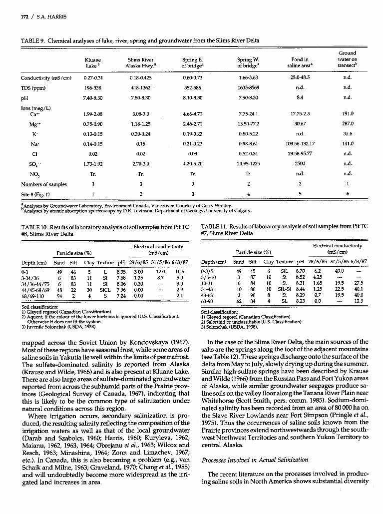
TABLE 9. Chemical analyses of lake, river, spring and groundwater from the Slims River Delta
Ground Kluane Slims River Spring E. Spring W. Pond in water on Lake a Alaska Hwy? of bridgea of bridgea saline areaa transectb
Conductivity (mS/cm) 0.27-0.31 0.18-0.425 0.60-0.73 1.66-3.63 25.0-48.5 n.d.
TDS (ppm) 196-338 418-1362 552-586 1635-8569 n.d. n.d.
PH 7.40-8.30 7.80-8.30 8.10-8.30 7.90-8.30 8.4 n.d.
Ions (meg/L) Cat+ 1.99-2.08 3.08-3.0 4.66-4.71 7.75-24.1 17.75-2.3 191.0
Mg" 0.75-0.90 1.18-1.25 2.46-2.71 13.50-77.2 30.67 287.0
K' 0.13-0.15 0.20-0.24 0.19-0.22 0.80-5.22 n.d. 35.6
Na' 0.14-0.15 0.16 0.21-0.23 0.98-8.61 109.56-132.17 141.0
c1- 0.02 0.02 0.03 0.52-0.31 29.58-95.77 n.d.
so," 1.73-1.92 2.70-3.0 4.20-5.20 24.95-1225 2500 n.d.
NO; Tr . Tr. Tr. Tr . n.d. n.d.
Numbers of samples 3 3 3 2 2 1
Site # (Fig. 1) 1 2 3 4 5 6
:Analyses by Groundwater Laboratory, Environment Canada, Vancouver. Courtesy of Gerry Whitley. Analyses by atomic absorption spectroscopy by D.R. Levinson, Department of Geology, University of Calgary.
TABLE 10. Results of laboratory analysis of soil samples from Pit TC #8, Slims River Delta
Electrical conductivity Particle size (%) (mS/cm)
Depth (cm) Sand Silt Clay Texture pH 29/6/85 31/5/86 6/8/87
0-3 49 46 5 L 8.35 3.00 12.0 10.5 3-34/36 6 83 11 Si 7.68 1.25 8.7 5.0 34/36-44/75 6 83 11 Si 8.06 0.20 - 3.0 44/45-68/69 48 22 30 SiCL 7.96 0.00 - 2.9 68/69-110 94 2 4 S 724 0.00 - 2.1
Soil classification:
2) Aquent, if the colour of the lower horizons is ignored (U.S. Classification). 1) Gleyed regosol (Canadian Classification).
3) Juvenile Solonchak (USDA, 1938). Otherwise it does not fit the system.
mapped across the Soviet Union by Kondovskaya (1967). Most of these regions have seasonal frost, while some areas of saline soils in Yakutia lie well within the limits of permafrost. The sulfate-dominated salinity is reported from Alaska (Krause and Wilde, 1966) and is also present at Kluane Lake. There are also large areas of sulfate-dominated groundwater reported from across the subhumid parts of the Prairie prov- inces (Geolo@cal Survey of Canada, 1967), indicating that this is likely to be the common type of salinization under natural conditions across this region.
Where irrigation occurs, secondary salinization is pro- duced, the resulting salinity reflecting the composition of the irrigation waters as well as that of the local groundwater (Darab and Szabolcs, 1960; Harris, 1960; Kuryleva, 1962; Maianu, 1962, 1963, 1964; Obrejanu et al., 1963; Wilcox and Resch, 1963; Minashina, 1964; Zonn and Limachev, 1967; etc.). In Canada, this is also becoming a problem (e.g., van Schaik and Milne, 1963; Graveland, 1970; Chang et al., 1985) and will undoubtedly become more widespread as the irri- gated land increases in area.
TABLE 11. Results of laboratory analysis of soil samples from Pit Tc #7, Slims River Delta
Electrical conductivity Particle size (%) (mS/cm)
Depth (cm) Sand Silt Clay Texture pH 28/6/85 31/5/86 6/8/87
0-3/5 49 45 6 SiL 8.70 6.2 49.0 - 3/5-10 3 87 10 Si 8.52 4.25 - 10-31 6 84 10 Si 8.31 1.65 19.5 27.5 31-43 10 80 10 SiL-Si 8.44 1.25 22.5 40.1 43-63 2 90 8 Si 8.29 0.7 19.5 40.0 63-90 62 34 4 SL 8.23 0.0 - 12.3
-
Soil classification:
2) Salorthid or unclassifiable (U.S. Classification). 1) Gleyed regosol (Canadian Classification).
3) Solonchak (USDA, 1938).
In the case of the Slims River Delta, the main sources of the salts are the springs along the foot of the adjacent mountains (see Table 12). These springs discharge onto the surface of the delta from May to July, slowly drying up during the summer. Similar high-sulfate springs have been described by Krause and Wilde (1966) from the Russian Pass and Fort Yukon areas of Alaska, while similar groundwater seepages produce sa- line soils on the valley floor along the Tanana River Plain near Whitehorse (Scott Smith, pers. comm. 1985). Sodium-domi- nated salinity has been recorded from an area of 80 000 ha on the Slave River Lowlands near Fort Simpson (Pringle et al., 1975). Thus the occurrences of saline soils known from the Prairie provinces extend northwestwards through the south- west Northwest Territories and southern Yukon Territory to central Alaska.
Processes Involved in Actual Salinization
The recent literature on the processes involved in produc- ing saline soils in North America shows substantial diversity
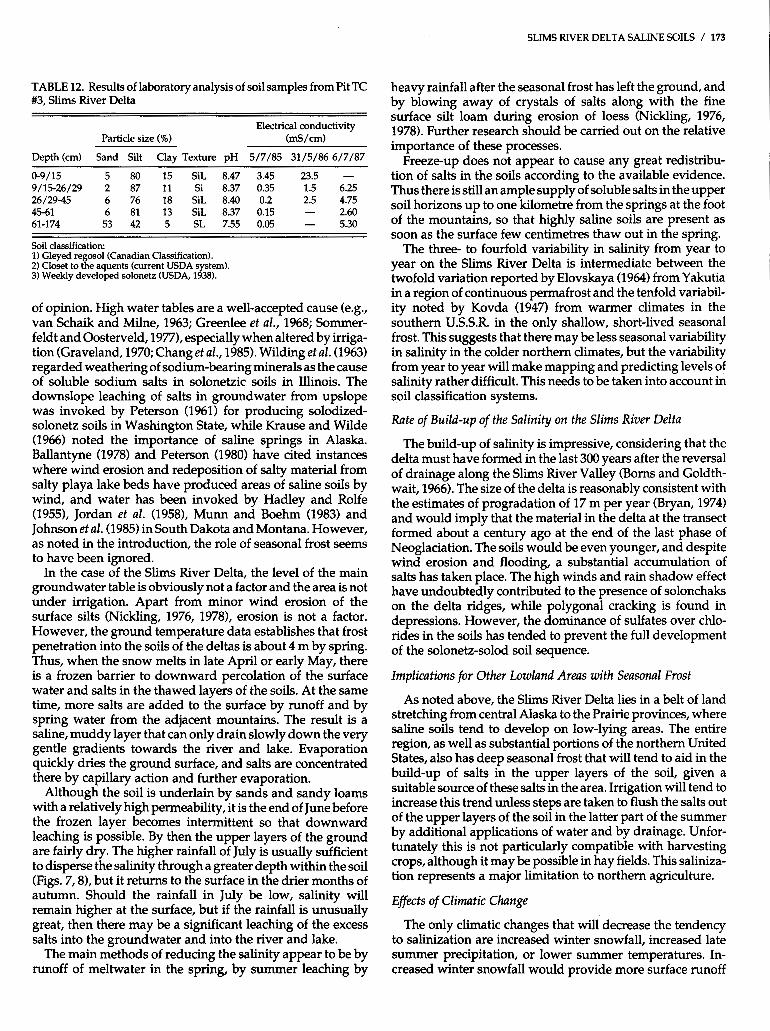
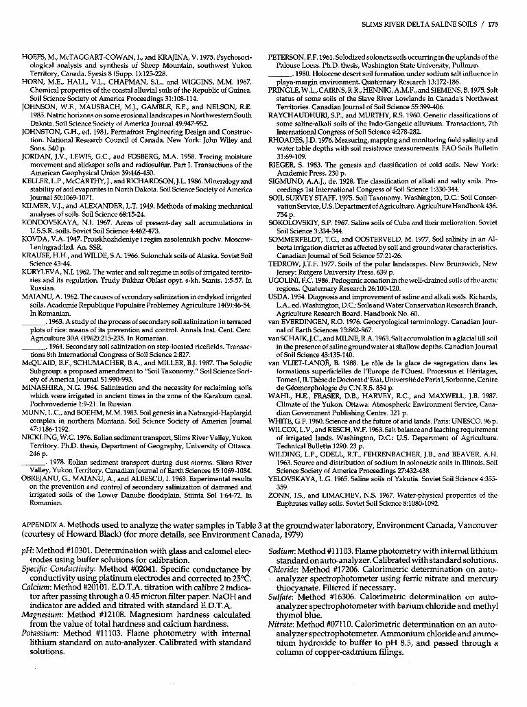
TABLE 12. Results of laboratory analysis of soil samples from Pit TC #3, Slims River Delta
Electrical conductivity Particle size (%) (mS/cm)
Depth (cm) Sand Silt Clay Texture pH 5/7/85 31/5/86 6/7/87
0-9/15 5 80 15 SiL 8.47 3.45 23.5 - 9/15-26/29 2 87 11 Si 8.37 0.35 1.5 6.25 26/29-45 6 76 18 SiL 8.40 0.2 2.5 4.75 45-61 6 81 13 SiL 8.37 0.15 - 2.60 61-174 53 42 5 SL 7.55 0.05 - 5.30
Soil classification: 1) Gleyed regosol (Canadian Classification). 2) Closet to the aquents (current USDA system). 3) Weekly developed solonetz (USDA, 1938).
of opinion. High water tables are a well-accepted cause (e.g., van Schaik and Milne, 1963; Greenlee et al., 1968; Sommer- feldt and Oosterveld, 1977), especially when altered by irriga- tion (Graveland, 1970; Chang et al., 1985). Wilding et al. (1963) regarded weathering of sodium-bearing minerals as the cause of soluble sodium salts in solonetzic soils in Illinois. The downslope leaching of salts in groundwater from upslope was invoked by Peterson (1961) for producing solodized- solonetz soils in Washington State, while Krause and Wilde (1966) noted the importance of saline springs in Alaska. Ballantyne (1978) and Peterson (1980) have cited instances where wind erosion and redeposition of salty material from salty playa lake beds have produced areas of saline soils by wind, and water has been invoked by Hadley and Rolfe (19551, Jordan et al. (19581, Munn and Boehm (1983) and Johnson et al. (1985) in South Dakota and Montana. However, as noted in the introduction, the role of seasonal frost seems to have been ignored.
In the case of the Slims River Delta, the level of the main groundwater table is obviously not a factor and the area is not under irrigation. Apart from minor wind erosion of the surface silts (Nickling, 1976, 19781, erosion is not a factor. However, the ground temperature data establishes that frost penetration into the soils of the deltas is about 4 m by spring. Thus, when the snow melts in late April or early May, there is a frozen barrier to downward percolation of the surface water and salts in the thawed layers of the soils. At the same time, more salts are added to the surface by runoff and by spring water from the adjacent mountains. The result is a saline, muddy layer that can only drain slowly down the very gentle gradients towards the river and lake. Evaporation quickly dries the ground surface, and salts are concentrated there by capillary action and further evaporation.
Although the soil is underlain by sands and sandy loams with a relatively high permeability, it is the end of June before the frozen layer becomes intermittent so that downward leaching is possible. By then the upper layers of the ground are fairly dry. The higher rainfall of July is usually sufficient to disperse the salinity through a greater depth within the soil (Figs. 7,8), but it returns to the surface in the drier months of autumn. Should the rainfall in July be low, salinity will remain higher at the surface, but if the rainfall is unusually great, then there may be a significant leaching of the excess salts into the groundwater and into the river and lake.
The main methods of reducing the salinity appear to be by runoff of meltwater in the spring, by summer leaching by
SLIMS RIVER DELTA SALINE SOILS / 173
heavy rainfall after the seasonal frost has left the ground, and by blowing away of crystals of salts along with the fine surface silt loam during erosion of loess (Nickling, 1976, 1978). Further research should be carried out on the relative importance of these processes.
Freeze-up does not appear to cause any great redistribu- tion of salts in the soils according to the available evidence. Thus there is still an ample supply of soluble salts in the upper soil horizons up to one kilometre from the springs at the foot of the mountains, so that highly saline soils are present as soon as the surface few centimetres thaw out in the spring.
The three- to fourfold variability in salinity from year to year on the Slims River Delta is intermediate between the twofold variation reported by Elovskaya (1964) from Yakutia in a region of continuous permafrost and the tenfold variabil- ity noted by Kovda (1947) from warmer climates in the southern U.S.S.R. in the only shallow, short-lived seasonal frost. This suggests that there may be less seasonal variability in salinity in the colder northern climates, but the variability from year to year will make mapping and predicting levels of salinity rather difficult. This needs to be taken into account in soil classification systems.
Rate of Build-up of the Salinity on the Slims River Delta
The build-up of salinity is impressive, considering that the delta must have formed in the last 300 years after the reversal of drainage along the Slims River Valley (Borns and Goldth- wait, 1966). The size of the delta is reasonably consistent with the estimates of progradation of 17 m per year (Bryan, 1974) and would imply that the material in the delta at the transect formed about a century ago at the end of the last phase of Neoglaciation. The soils would be even younger, and despite wind erosion and flooding, a substantial accumulation of salts has taken place. The high winds and rain shadow effect have undoubtedly contributed to the presence of solonchaks on the delta ridges, while polygonal cracking is found in depressions. However, the dominance of sulfates over chlo- rides in the soils has tended to prevent the full development of the solonetz-solod soil sequence.
Implications for Other Lowland Areas with Seasonal Frost
As noted above, the Slims River Delta lies in a belt of land stretching from central Alaska to the Prairie provinces, where saline soils tend to develop on low-lying areas. The entire region, as well as substantial portions of the northern United States, also has deep seasonal frost that will tend to aid in the build-up of salts in the upper layers of the soil, given a suitable source of these salts in the area. Irrigation will tend to increase this trend unless steps are taken to flush the salts out of the upper layers of the soil in the latter part of the summer by additional applications of water and by drainage. Unfor- tunately this is not particularly compatible with harvesting crops, although it may be possible in hay fields. This saliniza- tion represents a major limitation to northern agriculture.
Effects of Climatic Change
The only climatic changes that will decrease the tendency to salinization are increased winter snowfall, increased late summer precipitation, or lower summer temperatures. In- creased winter snowfall would provide more surface runoff

174 / S.A. HARRIS
and less winter frost penetration, while increased late sum- mer precipitation would aid in leaching out the salts. Lower summer temperatures would decrease the tendency to build up salts in the surface of the soil, but this regime is the opposite of what is predicted by the proponents of the C0,- induced climatic changes. Salinization of the type studied here will become a serious problem, making it difficult to successfully move the agricultural belt in Canada north- wards if this climatic warming occurs. Any available source of salts, e.g., springs (Krause and Wilde, 1966; this study) or irrigation waters (van Schaik and Milne, 1963; Graveland, 1970; Chang et al., 19851, will cause problems because the widespread deep seasonal frost will prevent leaching by melting snow in the spring. Similar problems will be encoun- tered in the areas of saline soils in the regions of deep seasonal frost and permafrost in China and the Soviet Union (e.g., Yelovskaya, 1965). This will mean that it will be difficult to successfully move the agricultural belt northwards in Can- ada, China and the Soviet Union if this climatic warming occurs.
CONCLUSIONS
The saline soils of the Slims River Delta are an interesting case study of their formation on a new land surface since the end of the last Neoglacial event. The source of the salts appears to be the springs and seepage sites at the foot of the mountain slopes. The deep seasonal frost prevents leaching of the salts through the soil into the relatively permeable subsoil so that they tend to be concentrated at the surface in early summer as the soils dry out. Unless heavy late-summer rains occur, the salts remain in the surface soil and a signifi- cant build-up can be demonstrated with time. A three- to fourfold variation in salinity may occur from year to year, which is intermediate between the range found in areas of continuous permafrost and the saline soils of warmer cli- mates.
The efflorescences are dominated by the hexahydrate of magnesium sulfate, while the associated clay mineral is se- piolite. The high sulfate content of the salts is probably the reason that the soils in the depressions have the morphology of solonetzic soils, yet the horizons remain reasonably friable. Solonchaks are widespread on the low ridges.
Vegetation distribution clearly indicates the approximate area of the saline soils, but the plant associations appear to be controlled more by soil moisture than salinity (see Table 7). There is considerable variation in the distribution and amount of salinity from year to year, and this is the probable reason for the species distribution of perennials merely indicating the approximate salinity distribution being reached in a given area in years of extreme salinity rather than actual values in a given year.
ACKNOWLEDGEMENTS
The field work was carried out with the financial help of NSERC Grant A-7483 and of Northern Training Grants to Denise Cook, Peter Hettstedt, Lynette Kirkham and Katherine OBrian. Parks Canada suggested the study and provided logistical help. Dr. A.A. Levinson (Department of Geology, University of Calgary) analyzed the samples of efflorescence as well as one water sample, while Gerry Whitley (Water Resources, Department of Indian and Northern Affairs, Whitehorse) arranged for the water analyses of spring, river and lake waters of mutual interest. They were carried out in the Vancouver
laboratories of Environment Canada. He also provided the equipment for measuring the water level of the Slims River. Dr. G.W. Argus, of the National Museums of Canada, Ottawa, identified the samples of Salix spp. from the delta, while Mrs. K. Wilkinson identified the grasses. The determinations of several species were confirmed by the Herbarium at the Biosystematics Research Institute, Department of Agriculture, Ottawa.
REFERENCES
BALDWW, M., KELLOGG, C.E., and THORP, J. 1938. Soil Classification. In: Soils and Man. 1938 Yearbook of Agriculture. Washington, D.C.: U.S. Gov- ernment Printing Office. 999-1001.
BALLANTYNE, A.K. 1978. Saline soils in Saskatchewan due to wind deposi- tion. Canadian Journal of Soil Science 58:107-108.
BARNETT, A.P. 1971. Hydrological Studies of the Slims River, Yukon Terri- tory, Canada, JuneAugust 1970. M.A. thesis, Department of Geography, University of Michigan.
BORNS,H.W.,andGOLDTHWAIT,R.P.1966.LatePleistocenefluctuationsof theKaskawulshGlacier,southwesternYukonTerritory,Canada. American Journal of Science 264600-619.
BRYAN, M.C. 1974. Sublacustrine morphology and deposition, Kluane Lake.
CANADA DEPARTMENT OF THE ENVIRONMENT. 1982. Monthly Record Icefield Ranges Research Publications, Scientific Results 4171-187.
- Meteorological Observations in Canada. Vol. 67, Nos. 1-12, Part 2. Downsview, Ontario: Atmospheric Environment Service.
CANADA SOIL SURVEY COMMITTEE. 1978. The Canadian System of Soil Classification. Canada Department of Agriculture, Publication 1646.164 p.
CHANG, C., KOZUB, G.C., and MacKAY, D.C. 1985. Soil salinity status and its relation tosomeof the soiland land properties of threeirrigation districts in southern Alberta. Canadian Journal of Soil Science 65:187-193.
DARAB, K., and SZABOLCS, I. 1960. Types of secondary salinization of soils in the irrigated zones of the region of the great Hungarian plains. Transac- tions of the 7th International Congress of Soil Science 1:535-542
ELOVSKAYA, L.G. 1964. Saline soils of Yakutia. Transactions, 8th Interna- tional Congress of Soil Science 2819-825.
EL'SWAIM, S.A., ARUNIA, S.S., and ABROL, I.P. 1983. Soil salinization: development of salt-affected soils. In: Carpenter, R.A., ed. Natural Systems
ENVIRONMENT CANADA. 1979. Analytical Methods Manual. Ottawa: for Development. London: Macmillan. 162-228.
Water Quality Branch, Environment Canada. FAHNESTOCK, R.K. 1969. Morphology of the Slims River. Icefield Ranges
Research Publications, Scientific Results 1:161-172. FOOTHILLS PIPELINES (YUKON) LTD. 1976. Environmental Statement.
Vol. 5,51, Table 19. GEOLOGICAL SURVEY OF CANADA. 1967. Groundwater in Canada. Geo-
IogicalSurvey of Canada, EconomicGeology Report24. Brown, LC., ed. 228 P.
GLINKA, K.D. 1931. Treatise on Soil Science. Moskva-Leningrad: Gosu- darstrennoe sel' skokhozyaistrennoe izadtel'stro. 4th ed. 612 p.
GRAVELAND, D.N. 1970. Migration of soluble salts in an irrigated field in relation to rainfall and irrigation. Canadian Journal of Soil Science 5043-46.
GREENLEE, G.M., PAWLUK, S., and BOWSER, W.E. 1968. Occurrence of soil salinity in the dry lands of south-western Alberta. Canadian Journal of Soil Science, 4865-75.
HADLEY, R.F., and ROLFE, B.N. 1955. Development and significance of seepage steps in slope erosion. Transactions of the American Geophysical Union 36:792-804.
HALLSWORTH, E.G., ROBERTSON, G.K., and GIBBONS, F.R. 1955. Studies in pedogenesis in New South Wales. VII. The 'gilgai' soils. Journal of Soil Science 9169-185.
HARRIS, S.A. 1958. The gilgaied and bad-structured soils of Central Iraq. Journal of Soil Science 8:l-34.
,1959. The classification of gilgaied soils: some evidence from North- ern Iraq. Journal of Soil Science 1027-33.
. 1960. Saline soils in the Kirkuk Plain. Journal of Soil Science, 2116- 130.
. 1983. Comparison of the climatic and geomorphic methods of pre- dicting permafrost distribution in western Yukon Territory. In: Permafrost: 4thInternationalConference Proceedings. Washington: National Academy Press. 450-455.
. 1987. Altitude trends in permafrost active layer thickness, Kluane Lake, Yukon Territory. Arctic 40:179-183.
SLIMS RIVER DELTA SALINE SOILS / 175
HOEFS, M., McTAGGART-COWAN, I., and KRAJINA, V. 1975. Psychosoci- ological analysis and synthesis of Sheep Mountain, southwest Yukon Territory, Canada. Syesis 8 (Supp. 1):125-228.
HORN, M.E., HALL, V.L., CHAPMAN, S.L., and WIGGINS, M.M. 1967. Chemical properties of the coastal alluvial soils of the Republic of Guinea. Soil Science Society of America Proceedings 31:108-114.
JOHNSON, W.F., MAUSBACH, M.J., GAMBLE, E.E., and NELSON, R.E. 1985. Natric horizons on some erosional landscapes in Northwestern South Dakota. Soil Science Society of America Journal 49:947-952.
JOHNSTON, G.H., ed. 1981. Permafrost Engineering Design and Construc- tion. National Research Council of Canada. New York John Wiley and Sons. 540 p.
JORDAN, J.V., LEWIS, G.C., and FOSBERG, M.A. 1958. Tracing moisture movement and slickspot soils and radiosulfur. Part I. Transactions of the American Geophysical Union 39446-450.
KELLER, L.P., McCARTHY, J., and RICHARDSON, J.L. 1986. Mineralogy and stability of soil evaporites in North Dakota. Soil Science Society of America Journal 501069-1071.
KILMER, V.J., and ALEXANDER, L.T. 1949. Methods of making mechanical analyses of soils. Soil Science 6815-24.
KONDOVSKAYA, N.I. 1967. Areas of present-day salt accumulations in U.S.S.R. soils. Soviet Soil Science 4462-473.
KOVDA, V.A. 1947. Proiskhozhdeniye i regim zasolennikh pochv. Moscow- LeningradIzd. An. SSR.
KRAUSE, H.H., and WILDE, S.A. 1966. Solonchak soils of Alaska. Soviet Soil Science 43-44.
KURYLEVA, N.I. 1962. The water and salt regime in soils of irrigated territo- ries and its regulation. Trudy Bukhar Oblast opyt. s-kh. Stants. 1:5-57. In Russian.
MAIANU, A. 1962. The causes of secondary salinization in endyked irrigated soils. Academie Republique Populaire Problemey Agriculture 14(9):46-54. In Romanian.
,1963. A study of the process of secondary soil salinization in terraced plots of rice: means of its prevention and control. Annals Inst. Cent. Cerc. Agriculture 30A (1962):215-235. In Romanian.
.1964. Secondary soil salinization on step-located ricefields. Transac- tions 8th International Congress of Soil Science 2827.
McQUAID, B.F., SCHUMACHER, B.A., and MILLER, B.J. 1987. The Solodic Subgroup: a proposed amendment to "Soil Taxonomy." Soil Science Soci- ety of America Journal 51:990-993.
MINASHIRA, N.G. 1964. Salinization and the necessity for reclaiming soils which were irrigated in ancient times in the zone of the Karakum canal. Pochvovedenie 1:9-21. In Russian.
MUNN, L.C., and BOEHM, M.M. 1983. Soil genesis in a Natrargid-Haplargid complex in northern Montana. Soil Science Society of America Journal 471186-1192.
NICKLING, W.G. 1976. Eolian sediment transport, Slims River Valley, Yukon Territory. Ph.D. thesis, Department of Geography, University of Ottawa.
. 1978. Eolian sediment transport during dust storms. Slims River Valley, Yukon Territory. Canadian Journal of Earth Sciences 15:1069-1084.
OBREJANU, G., MAIANU, A,, and ALBESCU, I. 1963. Experimental results on the prevention and control of secondary salinization of dammed and irrigated soils of the Lower Danube floodplain. Stiinta Sol 1:64-72. In Romanian.
246 p.
PETERSON, F.F. 1961. Solodized solonetz soils occurring in the uplands of the Palouse Loess. Ph.D. thesis, Washington State University, Pullman.
.1980. Holocene desert soil formation under sodium salt influence in playa-margin environment. Quaternary Research 13:172-186.
PRINGLE, W.L.,CAIRNS,R.R.,HENNIG, A.M.F., andSIEMENS, B. 1975. Salt status of some soils of the Slave River Lowlands in Canada's Northwest Territories. Canadian Journal of Soil Science 55:399-406.
RAYCHAUDHURI, S.P., and MURTHY, R.S. 1960. Genetic classifications of some saline-alkali soils of the Indo-Gangetic alluvium. Transactions, 7th International Congress of Soil Science 4278-282.
RHOADES, J.D. 1976. Measuring, mapping and monitoring field salinity and water table depths with soil resistance measurements. FA0 Soils Bulletin
RIEGER, S. 1983. The genesis and classification of cold soils. New York Academic Press. 230 p.
SIGMUND, A.A.J., de. 1928. The classification of alkali and salty soils. Pro- ceedings 1st International Congress of Soil Science 1:330-344.
SOIL SURVEY STAFF. 1975. Soil Taxonomy. Washington, D.C.: Soil Conser- vation Service, US. Department of Agriculture. Agriculture Handbook436.
SOKOLOVSKIY, S.P. 1967. Saline soils of Cuba and their melioration. Soviet Soil Science 3:334-344.
SOMMERFELDT, T.G., and OOSTERVELD, M. 1977. Soil salinity in an Al- berta irrigation district as affected by soil and groundwater characteristics. Canadian Journal of Soil Science 5721-26.
TEDROW, J.T.F. 1977. Soils of the polar landscapes. New Brunswick, New Jersey: Rutgers University Press. 639 p.
UGOLWI, F.C. 1986. Pedogenic zonation in the well-drained soils of the arctic regions. Quaternary Research 26100-120.
USDA. 1954. Diagnosis and improvement of saline and alkali soils. Richards, L.A.,ed. Washington, D.C.: Soilsand Water Conservation Research Branch, Agriculture Research Board. Handbook No. 60.
van EVERDINGEN, R.O. 1976. Geocryological terminology. Canadian Jour- nal of Earth Sciences 13:862-867.
van SCHAIK, J.C., and MILNE, R.A. 1963. Salt accumulation ina glacial till soil in the presence of saline groundwater at shallow depths. Canadian Journal of Soil Science 43:135-140.
van VLIET-LANOE, 8. 1988. Le rBle de la glace de segregation dans les formations superficielles de l'Europe de I'Ouest. Processus et Heritages, TomesI,II.Th~.sedeDoctoratd'Etat,UniversitedeParisI,Sorbonne,Centre de Gbmorphologie du C.N.R.S. 854 p.
WAHL, H.E., FRASER, D.B., HARVEY, R.C., and MAXWELL, J.B. 1987. Climate of the Yukon. Ottawa: Atmospheric Environment Service, Cana- dian Government Publishing Centre. 321 p.
WHITE, G.F. 1960. Science and the future of arid lands. Pans: UNESCO. 96 p. WILCOX, L.V., and RESCH, W.F. 1963. Salt balance and leaching requirement
of irrigated lands. Washington, D.C.: U.S. Department of Agriculture. Technical Bulletin 1290.23 p.
WILDING, L.P., ODELL, R.T., FEHRENBACHER, J.B., and BEAVER, A.H. 1963. Source and distribution of sodium in solonetzic soils in Illinois. Soil Science Society of America Proceedings 27432-438.
YELOVSKAYA, L.G. 1965. Saline soils of Yakutia. Soviet Soil Science 4355- 359.
ZONN, IS., and LIMACHEV, N.S. 1967. Water-physical properties of the Euphrates valley soils. Soviet Soil Science 8:1080-1092.
31:69-109.
754 p.
APPENDIX A. Methods used to analyze the water samples in Table 3 at the groundwater laboratory, Environment Canada, Vancouver (courtesy of Howard Black) (for more details, see Environment Canada, 1979)
pH. Method #10301. Determination with glass and calomel elec- Sodium: Method #11103. Flame photometry with internal lithium trodes using buffer solutions for calibration. standard on auto-analyzer. Calibrated with standard solutions.
Specific Conductivity: Method #02041. Specific conductance by Chloride: Method #17206. Calorimetric determination on auto- conductivity using platinum electrodes and corrected to 25°C. analyzer spectrophotometer using ferric nitrate and mercury
Calcium: Method #20101. E.D.T.A. titration with calibre 2 indica- thiocyanate. Filtered if necessary. tor after passing through a 0.45 micron filter paper. NaOH and Sulfate: Method #16306. Calorimetric determination on auto- indicator are added and titrated with standard E.D.T.A. analyzer spectrophotometer with barium chloride and methyl
Magnesium: Method #12108. Magnesium hardness calculated thymol blue. from the value of total hardness and calcium hardness. Nitrate: Method #07110. Calorimetric determination on an auto-
Potassium: Method #11103. Flame photometry with internal analyzer spectrophotometer. Ammoniumchloride and ammo- lithium standard on auto-analyzer. Calibrated with standard nium hydroxide to buffer to pH 8.5, and passed through a solutions. column of copper-cadmium filings.